Embed Size (px)
Citation preview

GISDATA
DICTIONARY
REGIONAL ENTERPRISE TOWER425 Sixth Avenue, Suite 2500Pittsburgh, PA 15219-1819
Tel (412) 391-5590Fax (412) 391-9160
GISDATA
DICTIONARY

SPC’s GIS covers the counties of Allegheny, Armstrong, Beaver, Butler, Fayette, Greene, Indiana, Washington andWestmoreland. SPC uses PC ARC/INFO and ArcView GIS software. SPC uses the PA Stateplane South projection, NAD1927, and the units are in feet.
GIS Coverage CoverageCoverage Type Description
AGSEC - (polygon) Agricultural Security AreasAIRPT - (polygon) AirportsAPARK - (polygon) Amusement ParksATTRC - (point) AttractionsBIKEPED - (line) SPC Bicycle/Pedestrian NetworkBLKPTS - (point) US Census Block PointsCAMPG - (polygon) CampgroundsCEMET - (polygon) CemeteriesCOUNTY - (polygon) County BoundaryOVER - (polygon) Satellite Land Cover - ALCOVERN, *S, & *E for Allegheny CountyFLOOD - (polygon) Flood Prone AreasENVIQ - (polygon) Environmental Bio-Diversity AreasGLAND - (polygon) PA State Game LandsGOLFC - (polygon) Golf CoursesGROUP - (polygon) Census Block Group BoundariesHISTO - (point) Historic AreasHOSPI - (polygon) HospitalsINDUS - (polygon) Industrial ParksMAJEM - (polygon) Major EmployersMILIT - (polygon) Military SitesMUNIC - (polygon) Municipal BoundariesNETW - (line) SPC’s Transportation Network / Major RoadsOPENS - (polygon) Other Open SpacesPAHOUSE - (polygon) PA State Legislative/Congressional DistrictsPASENATE - (polygon) PA State Senatorial DistrictsPARKS - (polygon) Parks (State, County, & Local)PNRLOTS - (point) Park & Ride LotsPONDS - (polygon) Lakes, Ponds, and Stream AreasPORTS - (point) River TerminalsPRIMEAG1 - (polygon) Prime Agricultural Soils - *1, *2, *3QUADS - (polygon) USGS quadrangle boundariesRALRD - (line) Railroad LinesRESER - (polygon) Forest / Environmental Reserves, State ForestsRIVER - (polygon) RiversROADS - (line) Streets & Roads - ROADSN, *S, & *E for Allegheny CountyRRCROSS - (point) Railroad Crossing LocationsSCHDIST - (polygon) School DistrictsSCHOOL - (point) SchoolsSEWER - (polygon) Sewer Service AreasSHOPC - (polygon) Shopping CentersSIGNAL - (point) Traffic SignalsSITES - (point) Historic SitesSLOPE - (polygon) 25% or Greater SlopeSRBRIDGE - (point) State owned/maintained BridgesSRCOUNT - (point) Traffic Counts along State Roads from PennDOT’s GISSTRDS - (line) State Roads from PennDOT’s GISSTREAMS - (line) Hydrology - Streams, Rivers, Lakes, & Pond BoundariesTRACT - (polygon) US Census TractsTRANSIT - (line) Transit RoutesTZONE - (polygon) Traffic Analysis ZonesUNIVS - (polygon) Colleges & UniversitiesUSCONGRS - (polygon) US Legislative/Congressional DistrictsUSPTS - (point) USGS Place NamesWAREH - (point) Public WarehousesWATER - (polygon) Water Service AreasWLAND - (polygon) WetlandsWSHED - (polygon) WatershedsZIPCD - (polygon) ZIPCodesZONING - (polygon) Zoning Districts - Allegheny County only
SPC’S GIS COVERAGES JANUARY 2000

ARC/INFO has default fields at the beginning of every coverage that must not be edited.
For polygon and point coverages these fields are:
AREA - Area of a polygon in square feet - zero for points
PERIMETER - Perimeter of the polygon in feet - zero for points
(cover)_ - ARC/INFO’s internal ID number
(cover)_ID - ARC/INFO’s User ID number
For line coverages these fields are:
FNODE_ - Internal ID number of the starting node - “from node”
TNODE_ - Internal ID number of the ending node - “to node”
LPOLY_ - Left polygon number
RPOLY_ - Right polygon number
LENGTH - Length in feet
(cover)_ - ARC/INFO’s internal ID number
(cover)_ID - ARC/INFO’s User ID number
SPC has standard attributes for several polygon coverages that were developed by SPC.Alpha-numeric codes in three fields (LAYER, CATEGORY, & SUBCAT) help to identify betweenspecific types of features and are outlined under SPC’s GIS Layer Listing. These coverages are:AGSEC, AIRPT, APARK, ATTRC, CAMPG, CEMET, ENVIQ, FLOOD, GLAND, GOLFC, HISTO,HOSPI, INDUS, MAJEM, MILIT, OPENS, PARKS, PRAG1, RESER, SEWER, SHOPC, SITES,SLOPE, UNIVS, WAREH, WATER, WLAND, & WSHED.
The fields are:
LAYER - SPC Layer Code
CATEGORY - SPC Category Code
SUBCAT - SPC Sub-Category Code
SEQUEN - SPC Sequence Number
COUNTY - Census County Code
DESCR - Description / Feature Name / Facility Name
MAPSYM - SPC Mapping symbol
PSEQUEN - SPC Sequence Number (LAYER + CATEGORY + SUBCAT + SEQUEN)
LABEL - SPC Mapping label - using USGS conventions
STANDARD ARC/INFO ATTRIBUTES
SPC ’S STANDARD ATTRIBUTES

AGSEC Attribute descriptions
Layer = T Category = 0 = Agricultural Security Area Subcat = 0 = No Sub-Category 1 = PA Farm Protection Program
END OF AGSEC FILE
AIRPT Attribute descriptions
Layer = I Category = 6 = Airport / Airifeld Subcat = 1 = Commercial 2 = Reliever 3 = General Avaiation - Public 4 = General Avaiation - Private 5 = Heliport
END OF AIRPT FILE
APARK Attribute descriptions
Layer = P Category = 5 = Amusement Park Subcat = 0 = No Sub-Category
END OF APARK FILE
ATTRC Attribute descriptions
Layer = H Category = 1 = Cultural Subcat = 0 = No Sub-Category 1 = Museum 2 = Art Gallery 3 = Zoological 4 = Library 5 = Botanical 6 = Astrological
2 = Support Facilities 1 = College/University 2 = Shopping Ctr-Regional 3 = Shopping Ctr-Other 4 = Airports-Commercial 5 = Airports-Other 6 = Hospital
3 = Recreational 1 = State Park 2 = Gameland 3 = County/Pgh Park 4 = Golf Course 5 = Private Park 6 = Sport Facility 7 = Water Orientated 8 = Caverns 9 = Trails
4 = Historic Significance 1 = Domestic/Social 2 = Govt/Education/Health 3 = Commerce/Trade 4 = Religious/Funeral 5 = Recreation/Cultural 6 = Agriculture/Subsistence 7 = Industrial 8 = Defense/Military 9 = Transportation
ATTRIBUTE DESCRIPTIONS FOR SPC’S COVERAGES

Category = 5 = Entertainment Subcat = 1 = Theater 2 = Amphitheater 3 = Social/Resorts 4 = Cruise 5 = Overlooks 6 = Winery 7 = Arts & Crafts 8 = Race Track
9 = Amusement Park
6 = Government 1 = Court House/Jail 2 = State Police 3 = Fire (not available) 4 = EMS (not available) 5 = Driver’s Testing Center 6 = Federal (misc.) 7 = State (misc.) 8 = County (misc.)
(Standard SPC Attributes)ATTYPE - Type of Attraction - Museum, Theater, Church, Building, etc.
END OF ATTRC FILE
BIKEPED Attribute descriptions
Layer = K Category = 1 = Right of Way- ROW Acquired, status unsure, may be under construction
2 = Roadway- Existing Road used as a Bicycle/Pedestrian Facility (Link)
3 = Existing Trail- Trail that currently exists
4 = Proposed Facility- Possible facility in the future, seen as conceptual
SAVID - SPC Internal ID NumberLAYCATSUB - Old Layer, Category, & SubCatIDNUM - Railroad Segment ID NumberLAYER - SPC Layer CodeCATEGORY - SPC Category CodeSUBCAT - SPC Sub-category CodeSEQUEN - SPC Sequence NumberCOUNTY - Census County CodeFACILITY - Name of Bike/Ped FeatureSEC_NAM - Rail-to-Trail SectionSR - State Route Number
END OF BIKEPED FILE
ATTRC Attribute descriptions ( continued )
Subcat = 0 = No Sub-Category 1 = Hiking/Pedestrian Only 2 = Multi-Use Facility 3 = Existing Roadway 4 = Road w/Shoulder Improvements 5 = Bike Lanes

BLKPTS Attribute descriptions - Point represents the centroid of a 1990 Census Block.
COUNTY - Census County CodeMCD - Census Municipality CodeTRACT - Census Tract NumberGROUP - Census Block Group NumberBLOCK - Census Block NumberTOTHU - Total Number of Housing UnitsSGLFAMUN - Number of Single Family UnitsOTHRUN - Number of “Other” UnitsVACUN - Number of Vacant UnitsOWNROCC - Number of Owner Occupied UnitsRENTOCC - Number of Renter Occupied UnitsMKTVAL - Average Market ValueRENT - Average RentTOTPOP - Total PopulationWHITEPOP - White PopulationBLACKPOP - Black PopulationOTHERPOP - Other PopulationGRPQTRPOP - Group Quarter PopulationHSLDPOP - Household PopulationTOTHSLD - Total Number of HouseholdsPERS_HSLD - Persons per HouseholdLANDAREA - Land Area of the Census BlockHU_ACRE - Housing Units per AcrePOP_ACRE - Population per AcreURCODE - Urban Area CodeURBNAME - Urban Area NameZONE - Traffic Analysis Zone Number
END OF BLKPTS FILE
CAMPG Attribute descriptions
Layer = P Category = 8 = Camp / Campground Subcat = 0 = No Sub-Category 1 = Federal 2 = State 3 = County 4 = Municipal 5 = Private-Non Profit 6 = Private-Other 7 = Public 8 = Membership 9 = Semi-Private
END OF CAMPG FILE
CEMET Attribute descriptions
Layer = P Category = 6 = Cemetery Subcat = 0 = No Sub-Category 1 = Federal 2 = State 3 = County 4 = Municipal 5 = Private-Non Profit 6 = Private-Other 7 = Public 8 = Membership 9 = Semi-Private
END OF CEMET FILE

COUNTY Attribute descriptions
COUNTY - Census County CodeNAME - County NameLAYER_ID - SPC Layer, Category, & Sub-category codeSQMILES - Area in square miles (Census)ACRES - Area in acres (Census)
END OF COUNTY FILE
COVER Attribute descriptions
* For additional information, refer to SPC’s “Satellite Land Cover” tables.
GRID_CODE - Land cover coding numberDESCR - Type of land coverACRES - Acreage of polygonGEN_CODE - Generalized land cover codeGEN_DESCR - Generalized land cover description
END OF COVER FILE
ENVIQ Attribute descriptions
Layer = M Category = 0 = Enviro Bio-Diversity Areas Subcat = 0 = No Sub-Category END OF ENVIQ FILE
FLOOD Attribute descriptions
Layer = G Category = 0 = No Category Subcat = 0 = No Sub-Category 1 = USGS Source 2 = HUD Source 3 = Army Corps of Engineers
END OF FLOOD FILE
GLAND Attribute descriptions
Layer = P Category = 2 = Gamelands Subcat = 0 = No Sub-Category 1 = Federal 2 = State 3 = County 4 = Municipal 5 = Private-Non Profit 6 = Private-Other 7 = Public 8 = Membership 9 = Semi-Private
END OF GLAND FILE
GOLFC Attribute descriptions
Layer = P Category = 4 = Golf Courses Subcat = 0 = No Sub-Category 1 = Federal 2 = State 3 = County 4 = Municipal 5 = Private-Non Profit 6 = Private-Other

GOLFC Attribute descriptions ( continued )
Layer = P Category = 4 = Golf Courses Subcat = 7 = Public 8 = Membership 9 = Semi-Private
NUMOFHOLES - Number of playing holes for the golf courseTELEPHONE - Golf Course’s Telephone Number
END OF GOLFC FILE
GROUP Attribute descriptions
The Current Block Group coverage was developed to identify distressed communities in the SPC Region for the KeystoneOpportunity Zones program.
COUNTY - Census County CodeTRACT - Census Tract NumberGROUP - Census Block NumberID - ID = County + Tract + GroupTOTPOP90 - Total Population - 1990 CensusUNEMPLYRAT - Unemployment RateUNEMPLY_FG - Unemployment Flag (Y/N) if more than 150% of US rate of 6.3%PCTBELPOV - Percent of Population Below Poverty LevelPOVERTY_FG - Poverty Flag (Y/N) if more than 20%PCTDSTHSNG - Percent distressed housingDSTHSNG_FG - Distressed housing flag (Y/N) if > 20% lack complete plumbing or > 1 person /roomMEDINC_URB - Median family income (MFI) for Urban areaMFI_FG_US - Flag (Y/N) if MFI is 80% or below US MFI of $35,225MFI_FG_MET - Flag (Y/N) if MFI is 80% or below US Metropolitan MFI of $37,896MEDINC_RUR - MFI for rural areaMFI_FG_PA - Flag (Y/N) if MFI is 80% or below PA MFI of $34,856MFI_RUR_PA - Flag (Y/N) if MFI is 80% or below PA Rural MFI of $16,717LIMIT_FLAG - Flag (Y/N) if any of the above flags = “Y” identifies a distressed communityURB_OR_RUR - Urban (U) or Rural (R) areaFILLER - Blank filler fieldHH90 - Number of Households from 1990 CensusPOP90 - Population 1990DUMMY - SPC Dummy flag
END OF GROUP FILE
HOSPI Attribute descriptions
Layer = I Category = 3 = Hospital Subcat = 0 = No Sub-Category 1 = General Care 2 = Special Care
END OF HOSPI FILE
INDUS Attribute descriptions
Layer = I Category = 2 = Industrial/Business Parks Subcat = 0 = No Sub-Category 1 = Industrial 2 = Office / Business 3 = Mixed
END OF INDUS FILE

MAJEM Attribute descriptions - 200 + emplyees, and NOT in an industrial park
Layer = I Category = 7 = Major Employers Subcat = 0 = No Sub-Category 1 = Durable Manufacturing 2 = Non-Durable Manufacturing 3 = Research & Development 4 = Other Non-Manufacturing 5 = Vacant Manufacturing 6 = Vacant Non-Manufacturing
END OF MAJEM FILE
MILIT Attribute descriptions
Layer = I Category = 5 = Military Site Subcat = 0 = No Sub-Category END OF MILIT FILE
MUNIC Attribute descriptions
COUNTY - Census County CodeMCD - Census Municipality CodeNAME - Municipality NameLAND - Census Land Area in Sq KmWATER - Census Water Area in Sq KmHH90 - Number of Households - 1990 CensusPOP90 - Total Population - 1990 CensusCNTL_ID - Census Control ID (County + MCD)LAYER_ID - SPC Layer IDMAPSYM - SPC Mapping SymbolLABEL - SPC Mapping Label - using USGS conventions
END OF MUNIC FILE
NETW Attribute descriptions
FDPRE - Prefix to Street NameFNAME - Street NameFTYPE - Street TypeFDSUF - Street SuffixLEFTADD1 - Segment + Offset / Street # for Geocoding, 1st on Left SideLEFTADD2 - Segment + Offset / Street # for Geocoding, Last on Left SideRGTADD1 - Segment + Offset / Street # for Geocoding, 1st on Right SideRGTADD2 - Segment + Offset / Street # for Geocoding, Last on Right SideOWNER - Owner ( 1 = state, 2 = county, 3 = local)NHS_FG - National Highway System Flag ( 0 = No, 1 = Yes)DIV_HWY_FG - Divided Highway Flag ( 0 = No, 1 = Yes)TRANSIT_G - Transit Flag ( 0 = No, 1 = Yes)COUNTY - CountyDIRECTION - Direction (1 = One way, 2 = Two way)LANE_TOTAL - Total # of lanesLGTH_MI - Length of Road Segment in MilesURB_RUL - Urban, Rural, or Small Urban AreaALTNAM - Alternative Street NameARANGE - Segment/Offset “Address” RangeTRAFF_VOL - Current Traffic VolumeZIPCODE - ZIPCodeSR - State Route #SEG - SegmentFUNC_CLASS - Functional ClassTNAME - Township Route #
END OF NETW FILE

OPENS Attribute descriptions
Layer = P Category = 9 = Other Open Spaces Subcat = 0 = No Sub-Category 1 = Federal 2 = State 3 = County 4 = Municipal 5 = Private-Non Profit 6 = Private-Other 7 = Public 8 = Membership 9 = Semi-Private
END OF OPENS FILE
PAHOUSE Attribute descriptions
Layer = C Category = 2 = PA State Congress Subcat = 0 = No Sub-Category
DISTNUM - PA Legislative District NumberREP_NAME - PA Representative’s NamePARTY - Political Party Affiliation
END OF PAHOUSE FILE
PARKS Attribute descriptions
Layer = P Category = 1 = Park / Fairgrounds Subcat = 0 = No Sub-Category 1 = Federal 2 = State 3 = County 4 = Municipal 5 = Private-Non Profit 6 = Private-Other 7 = Public 8 = Membership 9 = Semi-Private
END OF PARKS FILE
PASENATE Attribute descriptions
Layer = C Category = 1 = PA State Senate Subcat = 0 = No Sub-Category
DISTNUM - PA Senatorial District NumberREP_NAME - PA Senator’s NamePARTY - Political Party Affiliation
END OF PASENATE FILE
PNRLOTS Attribute descriptions
Layer = U Category = 8 = Park & Ride Lots Subcat = 0 = No Sub-category 1 = PennDOT 2 = Municipal 3 = PATransit 4 = Other Transit 5 = Private-Contract 6 = Private-Other 7 = Other
IDNUM - SPC ID NumberCOUNTY - Census County CodeMCD - Census Municipal Code

LAYER - SPC Layer CodeCATEGORY - SPC Category CodeSUBCAT - SPC Sub-category CodeSEQUEN - SPC Sequence NumberPSEQUEN - SPC Unique ID (Layer + Catgeory + Sub-Category + Sequence Number)SR - State Route Number, if Lot on State HighwayNAME - Name of Park & Ride LotROAD - Road on which Lot is LocatedINTERS - Intersecting Streets at Lot LocationOWNER - Owner of Lot - PennDOT, PAT, BCTA, Public, Private, County, or MunicipalLIGHTS - Is Lot Lighted - Y/NSURF_TYPE - Surface Type of Lot - Slag, Dirt, Asphalt, Gravel, Treated, or PavedSURF_COND - Condition of Lot - E = Excellent, G = Good, F = Fair, P = PoorTOT_SPACES - Total Number of Parking Spaces on the LotPNR_SPACES - Number of Spaces for Park & Ride UseDESIGN_PNR - Was Lot Designed as a Park & Ride Lot? - Y/NUSEAGE - F = Free Parking, P = Pay to ParkTRANS_SERV - Is Transit Service Available at the Lot - Y/NDIST_CBD - Distance to Pittsburgh CBD (miles)DIST_HWY - Distance to Nearest State Highway (miles)GIS_ID - SPC’s Internal GIS ID NumberSIGNED - Is the Lot Signed as a Park & Ride Lot - Y/NSHELTER - Is there a Shelter on the Lot? - Y/NPAVED - Is the Lot Paved? - Y/NPHONE - Is there a Telephone at the Lot? - Y/NFENCE - Is there a Fence around the Lot? - Y/NCORR_NAM - SPC Highway Corridor NameCORR_CODE - SPC Highway Corridor CodeXPROJ_NO - Project NumberSTATUS - Lot Status - E = Existing, P = Planned, C = Under ConstructionMAPSYM - SPC Mapping SymbolMAPLABEL - SPC’s Lot Map LabelSAVID - SPC’s ID Number
END OF PNRLOTS FILE
PONDS Attribute descriptions
Layer = L Category = 7 = Hydrology Subcat = 0 = No Sub-category 1 = River 2 = Lake 3 = Pond / Reservoir 4 = Stream - polygon 5 = Stream - line
6 = Island 7 = Dam
STRM_CODE - SPC named stream coding numberSTRM_NAME - Name of stream / pond / hydrologic featureSHED_SEQ - SPC Watershed sequence numberSHED_NAME - Watershed nameQUALITY - Water quality code - from PA DEP Title 25 Report - see table below*ORDER - PA DEP Stream orderDER_DRAIN - PA DEP drainage basin codeLAYER - SPC Layer CodeCATEGORY - SPC Category CodeSUBCAT - SPC Sub-category CodeCOUNTY - Census County codeMAPSYM - SPC Mapping Symbol
PNRLOTS Attribute descriptions ( continued )

*WATER QUALITY CODES - for Hydrology coverages
WWF - Warm Water FisheryHQWWF - High Quality Warm Water FisheryCWF - Cold Water FisheryHQCWF - High Quality Cold Water FisheryTSF - Trout Stocked FisheryHQTSF - High Quality Trout Stocked FisheryEV - Exceptional Value
END OF PONDS FILE
PORTS Attribute descriptions
Layer = E Category = 3 = River Terminals Subcat = 0 = No Sub-category 1 = River Terminal 2 = Private Facility 3 = Barge & Tow Company 4 = Terminal & Barge/Tow Company
COUNTY - Census County CodeLAYER - SPC Layer CodeCATEGORY - SPC Category CodeSUBCAT - SPC Sub-category CodeID - Terminal ID - Example: M-23.60-L (from Port of Pittsburgh)
- M represents River - A=Allegheny, M=Monongahela, O=Ohio - 23.60 is Milepost from Point State Park, Pittsburgh - L is Bank of River when Traveling Downstream - L=Left, R=Right
DESCR - River Terminal Name, Description or Company NameLABEL - SPC Mapping label - using USGS conventionsUSE - Designation of Terminal - TERMINAL, PRIVATE, BARGE/TOW, or TERM/BARGEUSENUM - Terminal Code - 1 = TERMINAL, 2 = PRIVATE, 3 = BARGE/TOW, 4 = TERM/BARGERAL_BRG - Direct Rail to Barge Transfer Code (Y=Yes, Else Blank)TRK_BRG - Direct Truck to Barge Transfer Code (Y=Yes, Else Blank)BRG_RAL - Direct Barge to Rail Transfer Code (Y=Yes, Else Blank)BRG_TRK - Direct Barge to Truck Transfer Code (Y=Yes, Else Blank)OPEN_STORE - Open Area Storage Capacity in AcresCOVR_STORE - Covered Storage Capacity in Square FeetTANK_STORE - Tank Storage Capacity in BarrelsRAL_SIDING - Rail Siding Flag (Y=Yes, Else Blank)RALSIDING1 - Rail Siding Railroad Company 1RALSIDING2 - Rail Siding Railroad Company 2RALSIDING3 - Rail Siding Railroad Company 3RALSIDING4 - Rail Siding Railroad Company 4
END OF PORTS FILE
PRIMEAG1 (*1, *2, *3) Attribute descriptions
Layer = S Category = 0 = Prime Agricultural Soils Subcat = 0 = No Sub-category END OF PRIMEAG1 FILE
QUADS Attribute descriptions
Layer = F Category = 6 = USGS 7 ½’ Quadrangle Subcat = 0 = No Sub-category
COUNTY - Census County code assigned by USGSQUAD - Name of the USGS quadrangle
END OF QUADS FILE
PONDS Attribute descriptions ( continued )

RALRD Attribute descriptions
UNIQUEID - Railroad Feature ID NumberCNTY_NAM - County NameSEG_NO - RR Segment NumberREGION - PennDOT RegionRR_NAM - RR NameFROM - Origin of RR SegmentTO - Destination of RR SegmentLIN_NAME - RR Line NameSTATUS - RR Line StatusLENGTH_GIS - Internal LengthMILEAGE - Mileage of RR SegmentLST_YROP - Last year Segment was in OperationYR_ABAN_AP - Year Abandonment AppliedDOKET_NO - Docket NumberYR_ABN_APP - Year Abandonment ApprovedYR_TK_REM - Year Track RemovedRE_OWNER - Real Estate OwnerCONDITN - Track ConditionRTT_PROJ - Rails-to-Trails ProjectRTT_STATUS - Rails-to-Trails StatusMAPSYM - SPC Mapping Symbol
END OF RALRD FILE
RESER Attribute descriptions
Layer = P Category = 3 = Forest Reserves Subcat = 0 = No Sub-category 1 = Federal
2 = State 3 = County 4 = Municipal 5 = Private-Non Profit 6 = Private-Other 7 = Public 8 = Membership 9 = Semi-Private
END OF RESER FILE
RIVER Attribute descriptions
MAPSYM - SPC Mapping NumberCOUNTY - Census County CodeRIVER - River Feature DescriptionLABEL - SPC Mapping LabelALCO - Allegheny County FlagARCO - Armstrong County FlagBECO - Beaver County FlagBUCO - Butler County FlagFACO - Fayette County FlagGRCO - Greene County FlagINCO - Indiana County FlagWACO - Washington County FlagWECO - Westmoreland County Flag
END OF RIVER FILE
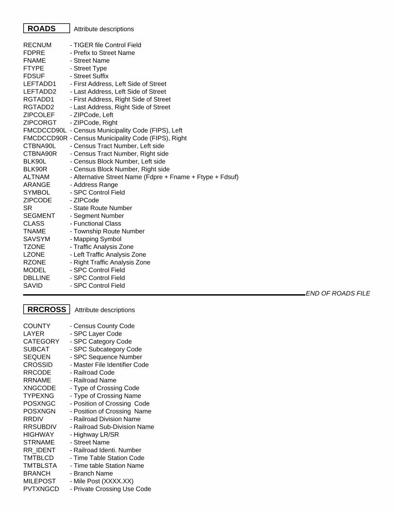
ROADS Attribute descriptions
RECNUM - TIGER file Control FieldFDPRE - Prefix to Street NameFNAME - Street NameFTYPE - Street TypeFDSUF - Street SuffixLEFTADD1 - First Address, Left Side of StreetLEFTADD2 - Last Address, Left Side of StreetRGTADD1 - First Address, Right Side of StreetRGTADD2 - Last Address, Right Side of StreetZIPCOLEF - ZIPCode, LeftZIPCORGT - ZIPCode, RightFMCDCCD90L - Census Municipality Code (FIPS), LeftFMCDCCD90R - Census Municipality Code (FIPS), RightCTBNA90L - Census Tract Number, Left sideCTBNA90R - Census Tract Number, Right sideBLK90L - Census Block Number, Left sideBLK90R - Census Block Number, Right sideALTNAM - Alternative Street Name (Fdpre + Fname + Ftype + Fdsuf)ARANGE - Address RangeSYMBOL - SPC Control FieldZIPCODE - ZIPCodeSR - State Route NumberSEGMENT - Segment NumberCLASS - Functional ClassTNAME - Township Route NumberSAVSYM - Mapping SymbolTZONE - Traffic Analysis ZoneLZONE - Left Traffic Analysis ZoneRZONE - Right Traffic Analysis ZoneMODEL - SPC Control FieldDBLLINE - SPC Control FieldSAVID - SPC Control Field
END OF ROADS FILE
RRCROSS Attribute descriptions
COUNTY - Census County CodeLAYER - SPC Layer CodeCATEGORY - SPC Category CodeSUBCAT - SPC Subcategory CodeSEQUEN - SPC Sequence NumberCROSSID - Master File Identifier CodeRRCODE - Railroad CodeRRNAME - Railroad NameXNGCODE - Type of Crossing CodeTYPEXNG - Type of Crossing NamePOSXNGC - Position of Crossing CodePOSXNGN - Position of Crossing NameRRDIV - Railroad Division NameRRSUBDIV - Railroad Sub-Division NameHIGHWAY - Highway LR/SRSTRNAME - Street NameRR_IDENT - Railroad Identi. NumberTMTBLCD - Time Table Station CodeTMTBLSTA - Time table Station NameBRANCH - Branch NameMILEPOST - Mile Post (XXXX.XX)PVTXNGCD - Private Crossing Use Code
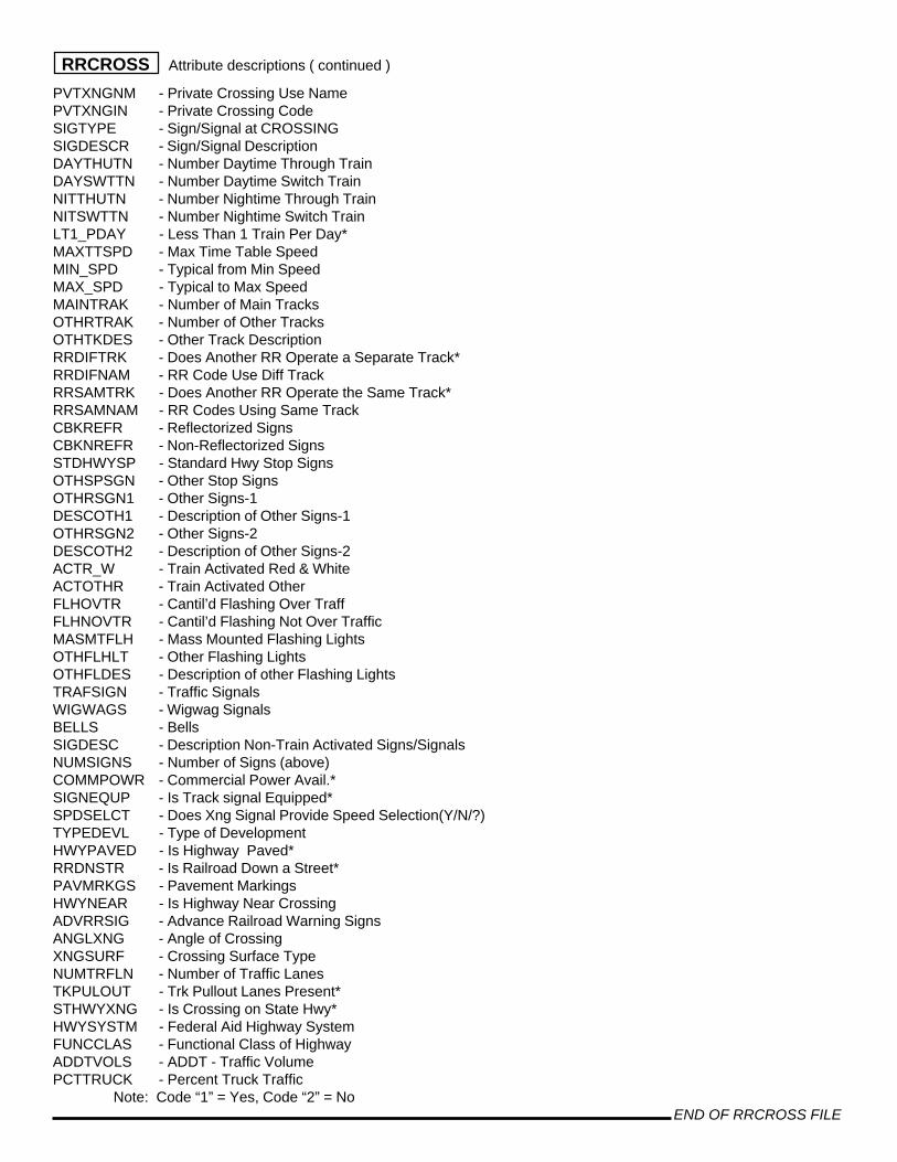
PVTXNGNM - Private Crossing Use NamePVTXNGIN - Private Crossing CodeSIGTYPE - Sign/Signal at CROSSINGSIGDESCR - Sign/Signal DescriptionDAYTHUTN - Number Daytime Through TrainDAYSWTTN - Number Daytime Switch TrainNITTHUTN - Number Nightime Through TrainNITSWTTN - Number Nightime Switch TrainLT1_PDAY - Less Than 1 Train Per Day*MAXTTSPD - Max Time Table SpeedMIN_SPD - Typical from Min SpeedMAX_SPD - Typical to Max SpeedMAINTRAK - Number of Main TracksOTHRTRAK - Number of Other TracksOTHTKDES - Other Track DescriptionRRDIFTRK - Does Another RR Operate a Separate Track*RRDIFNAM - RR Code Use Diff TrackRRSAMTRK - Does Another RR Operate the Same Track*RRSAMNAM - RR Codes Using Same TrackCBKREFR - Reflectorized SignsCBKNREFR - Non-Reflectorized SignsSTDHWYSP - Standard Hwy Stop SignsOTHSPSGN - Other Stop SignsOTHRSGN1 - Other Signs-1DESCOTH1 - Description of Other Signs-1OTHRSGN2 - Other Signs-2DESCOTH2 - Description of Other Signs-2ACTR_W - Train Activated Red & WhiteACTOTHR - Train Activated OtherFLHOVTR - Cantil’d Flashing Over TraffFLHNOVTR - Cantil’d Flashing Not Over TrafficMASMTFLH - Mass Mounted Flashing LightsOTHFLHLT - Other Flashing LightsOTHFLDES - Description of other Flashing LightsTRAFSIGN - Traffic SignalsWIGWAGS - Wigwag SignalsBELLS - BellsSIGDESC - Description Non-Train Activated Signs/SignalsNUMSIGNS - Number of Signs (above)COMMPOWR - Commercial Power Avail.*SIGNEQUP - Is Track signal Equipped*SPDSELCT - Does Xng Signal Provide Speed Selection(Y/N/?)TYPEDEVL - Type of DevelopmentHWYPAVED - Is Highway Paved*RRDNSTR - Is Railroad Down a Street*PAVMRKGS - Pavement MarkingsHWYNEAR - Is Highway Near CrossingADVRRSIG - Advance Railroad Warning SignsANGLXNG - Angle of CrossingXNGSURF - Crossing Surface TypeNUMTRFLN - Number of Traffic LanesTKPULOUT - Trk Pullout Lanes Present*STHWYXNG - Is Crossing on State Hwy*HWYSYSTM - Federal Aid Highway SystemFUNCCLAS - Functional Class of HighwayADDTVOLS - ADDT - Traffic VolumePCTTRUCK - Percent Truck Traffic
Note: Code “1” = Yes, Code “2” = No END OF RRCROSS FILE
RRCROSS Attribute descriptions ( continued )

SCHDIST Attribute descriptions
LAYER - SPC Layer CodeCATEGORY - SPC Category CodeSUBCAT - SPC Sub-category CodeSEQUEN - SPC Sequence NumberCOUNTY - Census County CodePSEQUEN - SPC Sequence Number (LAYER + CATEGORY + SUBCAT + SEQUEN)MAPSYM - SPC Mapping symbolDISTNUM - School District NumberDISTNAM - School District Name
END OF SCHDIST FILE
SCHOOL Attribute descriptions
Layer = U Category = 6 = School or School Facility Subcat = 0 = No Sub-category 1 = High School 2 = Middle School 3 = Grade School 4 = K - 12 School 5 = K - Jr High School 6 = Jr/Sr High School 7 = Vocational School 8 = District Administration 9 = Other Support Facility
DESCR - Description (Facility Name)MAPSYM - SPC Mapping symbolPSEQUEN - SPC Sequence Number (LAYER + CATEGORY + SUBCAT + SEQUEN)DISTNUM - School District NumberDISTNAM - School District NameSTUDENT_93 - Number of Students 1993-1994 school yearEMPLOY_93 - Number of Employees 1993-1994 school yearSTUDENT_95 - Number of Students 1995-1996 school yearEMPLOY_95 - Number of Employees 1995-1996 school year
END OF SCHOOL FILE
SEWER Attribute descriptions
Layer = D Category = 3 = Existing Sewer Service Subcat = 0 = No Sub-category 4 = Planned Sewer Service 1 = Authority
2 = Municipal 3 = Private
END OF SEWER FILE
SHOPC Attribute descriptions
Layer = I Category = 1 = Shopping Centers Subcat = 0 = No Sub-category 1 = Super-Regional
2 = Regional 3 = Community 4 = Neighborhood
END OF SHOPC FILE
SIGNAL Attribute descriptions
Layer = U Category = 2 = Traffic Signals Subcat = 2 = Traffic Signal
SEQ_NUM - SPC ID NumberCOUNTY - Census County Code

LAYER - SPC Layer CodeCATEGORY - SPC Category CodeSUBCAT - SPC Sub-category CodeSEQUEN - SPC Sequence NumberPSEQUEN - SPC Unique ID (Layer + Catgeory + Sub-Category + Sequence Number)PADT_ID - PENNDOT ID NumberSTATUS - Status of SignalOPERATION - Type of Signal OperationPERMIT - PENNDOT Permit NumberISSUE_DATE - Date Permit was IssuedPERM_DATE - Date Permit was receivedUPGD_DATE - Date Signal was upgradedTIMG_DATE - Date Signal was last TimedMCD - Municipality NameMAIN_ST - “Main” Street of Signal LocationMAIN_SR - “Main” State Route of Signal LocationMAIN_SEG - “Main” Segment of Signal LocationMAIN_OFST - “Main” Offset of Signal LocationINTS_ST - Intersecting Street NameINTS_SR - Intersecting Street State Route NumberINTS_SEG - Intersecting Street SegmentINTS_OFST - Intersecting Street OffsetSIG_CONN - Interconnected signal number / identifier
END OF SIGNAL FILE
SITES Attribute descriptions
Layer = U Category = 5 = Historic Site Subcat = 0 = No Sub-category 1 = Domestic/Social 2 = Govt/Education/Health 3 = Commerce/Trade 4 = Religious/Funerary 5 = Recreation/Cultural
6 = Agriculture/Subsistence 7 = Industrial 8 = Defense/Military 9 = Transportation
END OF SITES FILE
SLOPE Attribute descriptions
Layer = R Category = 0 = 25% Slope Subcat = 0 = No Sub-category
END OF SLOPE FILE
SRBRIDGE Attribute descriptions
COUNTY - Census County CodeMCD - Census Municipality CodeSR - State Route NumberSEG - State Route SegmentOFSET - State Route OffsetREC_NO - SPC Database Record NumberPD_DESCR - PennDOT Description of BridgeLOCATION - Bridge Location Description
END OF SRBRIDGE FILE
SIGNAL Attribute descriptions ( continued )

SRCOUNT Attribute descriptions
ADDRESS - SR, Segment, & Offset “Address” of Count LocationREC_NO - SPC Record NumberLAYER - SPC Layer Code = ‘U’CATEGORY - SPC Category Code = 3SUBCAT - SPC Sub-Category Code - 1 = on State Road, 2 = on County or Local RoadSEQUEN - SPC Sequence NumberPSEQUEN - SPC Unique ID (Layer + Catgeory + Sub-Category + Sequence #)COUNTY - Census County CodeMAP - HPMS & Project Map NumberF_CLS - Functional ClassHPMS_ID - HPMS ID NumberSUBD - HPMS Subdivision NumberSR_NO - State Route NumberSEG - Segment #OFSET - OffsetRTE - State Route NumberYR - Year of the Traffic CountDATE - Date of the Traffic Count - MM/DD/YYSURV_TP - Survey Abbreviation (HPMS, PDOT, etc...)LANES - Number of LanesOWNER - Owner of Road segment (1=PA, 2=MCD, 3=County)LOC_DESC - Location DescriptionSTR_NAME - Street NameLGTH - Length of Street Segment - Miles (HPMS)A24HR_CNT - Number of Vehicles in a 24 Hour PeriodDIR - Direction of Travel on Street Segment (1=One Way, 2=Two Way)A8HR_FG - Flag for an Eight Hour Count (10AM - 6PM)DAY_WK - Day of The Week (1=Mon,...7=Sun)AM_PK_HR - Beginning Hour Peak Traffic - AMAM_PK_VOL - Peak Traffic Volume - AMPM_PK_HR - beginning Hour Peak Traffic - PMPM_PK_VOL - Peak Traffic Volume - PMFED_ID - Federal Traffic Count ID - HPMS - Locals OnlyFED_SEC - Federal Road Segment - HPMS - Locals OnlyARSRCLN_ - ArcInfo Control FieldARSRCLN_ID - ArcInfo Control FieldARSRCLN_SI - ArcInfo Control Field
END OF SRCOUNT FILE
STRDS Attribute descriptions
FDPRE - Road PrefixFNAME - Road name (all are SR #)FTYPE - Road type (all are “Hwy”)COUNTY - County codeLEFTADD1 - 1st address, left side (segment + offset)LEFTADD2 - Last address, left side (segment + offset)SR - State Route NumberSEGMENT - Segment #OFFSET_BGN - Beginning Offset of Segment (feet)OFFSET_END - Ending Offset of Segment (feet)SIDE_IND - Side Indicator for “split” HighwaysYR_BUILT - Year Road BuiltYR_SURFACE - Year Road was Last ResurfacedFAC_TYPE - Facility TypeTOTAL_WDTH - Pavement WidthSURF_TYPE - Surface TypeLANE_CNT - Number of Lanes
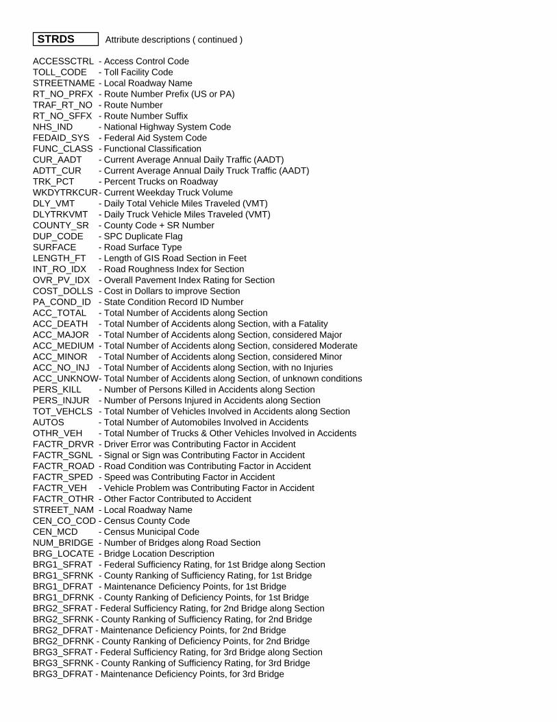
ACCESSCTRL - Access Control CodeTOLL_CODE - Toll Facility CodeSTREETNAME - Local Roadway NameRT_NO_PRFX - Route Number Prefix (US or PA)TRAF_RT_NO - Route NumberRT_NO_SFFX - Route Number SuffixNHS_IND - National Highway System CodeFEDAID_SYS - Federal Aid System CodeFUNC_CLASS - Functional ClassificationCUR_AADT - Current Average Annual Daily Traffic (AADT)ADTT_CUR - Current Average Annual Daily Truck Traffic (AADT)TRK_PCT - Percent Trucks on RoadwayWKDYTRKCUR- Current Weekday Truck VolumeDLY_VMT - Daily Total Vehicle Miles Traveled (VMT)DLYTRKVMT - Daily Truck Vehicle Miles Traveled (VMT)COUNTY_SR - County Code + SR NumberDUP_CODE - SPC Duplicate FlagSURFACE - Road Surface TypeLENGTH_FT - Length of GIS Road Section in FeetINT_RO_IDX - Road Roughness Index for SectionOVR_PV_IDX - Overall Pavement Index Rating for SectionCOST_DOLLS - Cost in Dollars to improve SectionPA_COND_ID - State Condition Record ID NumberACC_TOTAL - Total Number of Accidents along SectionACC_DEATH - Total Number of Accidents along Section, with a FatalityACC_MAJOR - Total Number of Accidents along Section, considered MajorACC_MEDIUM - Total Number of Accidents along Section, considered ModerateACC_MINOR - Total Number of Accidents along Section, considered MinorACC_NO_INJ - Total Number of Accidents along Section, with no InjuriesACC_UNKNOW- Total Number of Accidents along Section, of unknown conditionsPERS_KILL - Number of Persons Killed in Accidents along SectionPERS_INJUR - Number of Persons Injured in Accidents along SectionTOT_VEHCLS - Total Number of Vehicles Involved in Accidents along SectionAUTOS - Total Number of Automobiles Involved in AccidentsOTHR_VEH - Total Number of Trucks & Other Vehicles Involved in AccidentsFACTR_DRVR - Driver Error was Contributing Factor in AccidentFACTR_SGNL - Signal or Sign was Contributing Factor in AccidentFACTR_ROAD - Road Condition was Contributing Factor in AccidentFACTR_SPED - Speed was Contributing Factor in AccidentFACTR_VEH - Vehicle Problem was Contributing Factor in AccidentFACTR_OTHR - Other Factor Contributed to AccidentSTREET_NAM - Local Roadway NameCEN_CO_COD - Census County CodeCEN_MCD - Census Municipal CodeNUM_BRIDGE - Number of Bridges along Road SectionBRG_LOCATE - Bridge Location DescriptionBRG1_SFRAT - Federal Sufficiency Rating, for 1st Bridge along SectionBRG1_SFRNK - County Ranking of Sufficiency Rating, for 1st BridgeBRG1_DFRAT - Maintenance Deficiency Points, for 1st BridgeBRG1_DFRNK - County Ranking of Deficiency Points, for 1st BridgeBRG2_SFRAT - Federal Sufficiency Rating, for 2nd Bridge along SectionBRG2_SFRNK - County Ranking of Sufficiency Rating, for 2nd BridgeBRG2_DFRAT - Maintenance Deficiency Points, for 2nd BridgeBRG2_DFRNK - County Ranking of Deficiency Points, for 2nd BridgeBRG3_SFRAT - Federal Sufficiency Rating, for 3rd Bridge along SectionBRG3_SFRNK - County Ranking of Sufficiency Rating, for 3rd BridgeBRG3_DFRAT - Maintenance Deficiency Points, for 3rd Bridge
STRDS Attribute descriptions ( continued )

BRG3_DFRNK - County Ranking of Deficiency Points, for 3rd BridgeBRG4_SFRAT - Federal Sufficiency Rating, for 4th Bridge along SectionBRG4_SFRNK - County Ranking of Sufficiency Rating, for 4th BridgeBRG4_DFRAT - Maintenance Deficiency Points, for 4th BridgeBRG4_DFRNK - County Ranking of Deficiency Points, for 4th BridgeFLAG - SPC Coding Flag
END OF STRDS FILE
STREAMS Attribute descriptions
Layer = L Category = 7 = Hydrology Subcat = 0 = No Sub-category 1 = River 2 = Lake 3 = Pond / Reservoir 4 = Stream - polygon 5 = Stream - line 6 = Island 7 = Dam
STRM_CODE - SPC named stream coding numberSTRM_NAME - Name of stream / pond / hydrologic featureSHED_SEQ - SPC Watershed sequence numberSHED_NAME - Watershed nameQUALITY - Water quality code - from PA DEP Title 25 Report - see table below*ORDER - PA DEP Stream orderDER_DRAIN - PA DEP drainage basin codeLAYER - SPC Layer CodeCATEGORY - SPC Category CodeSUBCAT - SPC Sub-category CodeCOUNTY - Census County code
*WATER QUALITY CODES - for Hydrology coverages
WWF - Warm Water FisheryHQWWF - High Quality Warm Water FisheryCWF - Cold Water FisheryHQCWF - High Quality Cold Water FisheryTSF - Trout Stocked FisheryHQTSF - High Quality Trout Stocked FisheryEV - Exceptional Value
END OF STREAMS FILE
TRACT Attribute descriptions
COUNTY - County NumberTRACT - Census Tract NumberLAND - Acres of Land in TractWATER - Acres of Water in TractHH90 - Number of Households in Tract (1990)POP90 - Population of Tract (1990)CNTL_ID - SPC Control ID (County + Tract)LAYER_ID - Census Control FieldTOTPOP - Total 1990 Census PopulationABOVEPOV - Population Above the Poverty LevelBELOWPOV - Population Below the Poverty LevelPOVCLASS - SPC Classification FieldCLS8_I - SPC Classification Field
STRDS Attribute descriptions ( continued )

CLS8_1 - SPC Classification FieldCLS9_15 - SPC Classification FieldAVCLS - SPC Classification FieldCLS9_4 - SPC Classification FieldHSLDINC - 1990 Census Household IncomePERCAP - 1990 Census Per Capita IncomePCTBELPV - Percent of 1990 Census Population Below the Poverty LevelPOPEMP - 1990 Census Population of Employed PersonsPOPUNEMP - 1990 Census Population of Un-Employed PersonsLABFORCE - 1990 Census Population of Total Labor Force (POPEMP + POPUNEMP)PCTUNEMP - Percent of Un-Employed Persons, 1990 CensusMFIRATIO - Ratio: Median Family Income (MFI) divided by PA MFI, based on Urban or RuralURB_RURL - Tract Designation - U = Urban, R = RuralBELPOVFG - Flag (*) to Denote if 20%+ Population Below Poverty LevelUNEMPFG - Flag (*) to Denote if % Un-Employed Exceeds PA Rate of 6% x 1.25MFIRATFG - Flag (*) to Denote if Ratio of Tract MFI to PA MFI is .80 or LessKEYOPZN - Flag (Y/N) to Denote if Tract can be Part of a Keystone Opportunity Zone
END OF TRACT FILE
TRANSIT Attribute descriptions
SAVID - SPC Unique ID NumberALTNAM - Street NameFRNODE - Map Plot “From” NodeTONODE - Map Plot “To” NodeKEY_TO_FM - SPC key matching field (FRNODE + TONODE)COUNTY - Census County CodeSR - State Route #FUNC_CLASS - Functional ClassNHS_FG - National Highway System Flag ( 0 = No, 1 = Yes)CMS_COR - SPC Congestion Management System Corridor CodeDIRECTION - Direction (1 = One way, 2 = Two way)LANE_TOTAL - Total # of lanesLGTH_MI - Length of Road Segment in MilesURB_RUL - Urban, Rural, or Small Urban AreaROUTES - Route Numbers Using the Current Street Segment (delimited by |)PAT - Port Authority of Allegheny County flagBCTA - Beaver County Transit Authority flagBTA - Butler County Transit Authority flagGGC - GG & C Bus Company, Inc. (Washington County) flagLIMO - Airport Limousine Co., flagLINCLN - Lincoln Coach (Butler County) flagMCTA - Mid County Transit Authority flagMMVTA - Mid Mon-Valley Transit Authority flagWCTA - Westmoreland County Transit Authority flagLAYER - SPC Layer CodeCATEGORY - SPC Category CodeSUBCAT - SPC Sub-Category CodeSAVSYM - SPC Mapping SymbolNUM_COS - Number of Transit Companies Using Segment
END OF TRANSIT FILE
TZONE Attribute descriptions
ZONE - SPC Traffic Analysis Zone NumberCOUNTY - Census County Code (Census, 000 = Pittsburgh)MCD_CODE - Municipal Code (Census)MCD_NAME - Municipality Name or, if Pittsburgh, Neighborhood
TRACT Attribute descriptions ( continued )
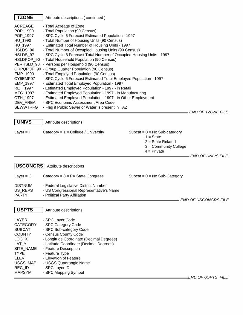
ACREAGE - Total Acreage of ZonePOP_1990 - Total Population (90 Census)POP_1997 - SPC Cycle 6 Forecast Estimated Population - 1997HU_1990 - Total Number of Housing Units (90 Census)HU_1997 - Estimated Total Number of Housing Units - 1997HSLDS_90 - Total Number of Occupied Housing Units (90 Census)HSLDS_97 - SPC Cycle 6 Forecast Total Number of Occupied Housing Units - 1997HSLDPOP_90 - Total Household Population (90 Census)PERHSLD_90 - Persons per Household (90 Census)GRPQPOP_90 - Group Quarter Population (90 Census)EMP_1990 - Total Employed Population (90 Census)CY6EMP97 - SPC Cycle 6 Forecast Estimated Total Employed Population - 1997EMP_1997 - Estimated Total Employed Population - 1997RET_1997 - Estimated Employed Population - 1997 - in RetailMFG_1997 - Estimated Employed Population - 1997 - in ManufacturingOTH_1997 - Estimated Employed Population - 1997 - in Other EmploymentDEV_AREA - SPC Economic Assessment Area CodeSEWWTRFG - Flag if Public Sewer or Water is present in TAZ
END OF TZONE FILE
UNIVS Attribute descriptions
Layer = I Category = 1 = College / University Subcat = 0 = No Sub-category 1 = State 2 = State Related 3 = Community College
4 = Private END OF UNIVS FILE
USCONGRS Attribute descriptions
Layer = C Category = 3 = PA State Congress Subcat = 0 = No Sub-Category
DISTNUM - Federal Legislative District NumberUS_REPS - US Congressional Representative’s NamePARTY - Political Party Affiliation
END OF USCONGRS FILE
USPTS Attribute descriptions
LAYER - SPC Layer CodeCATEGORY - SPC Category CodeSUBCAT - SPC Sub-category CodeCOUNTY - Census County CodeLOG_X - Longitude Coordinate (Decimal Degrees)LAT_Y - Latitude Coordinate (Decimal Degrees)SITE_NAME - Feature DescriptionTYPE - Feature TypeELEV - Elevation of FeatureUSGS_MAP - USGS Quadrangle NameREC_ID - SPC Layer IDMAPSYM - SPC Mapping Symbol
END OF USPTS FILE
TZONE Attribute descriptions ( continued )
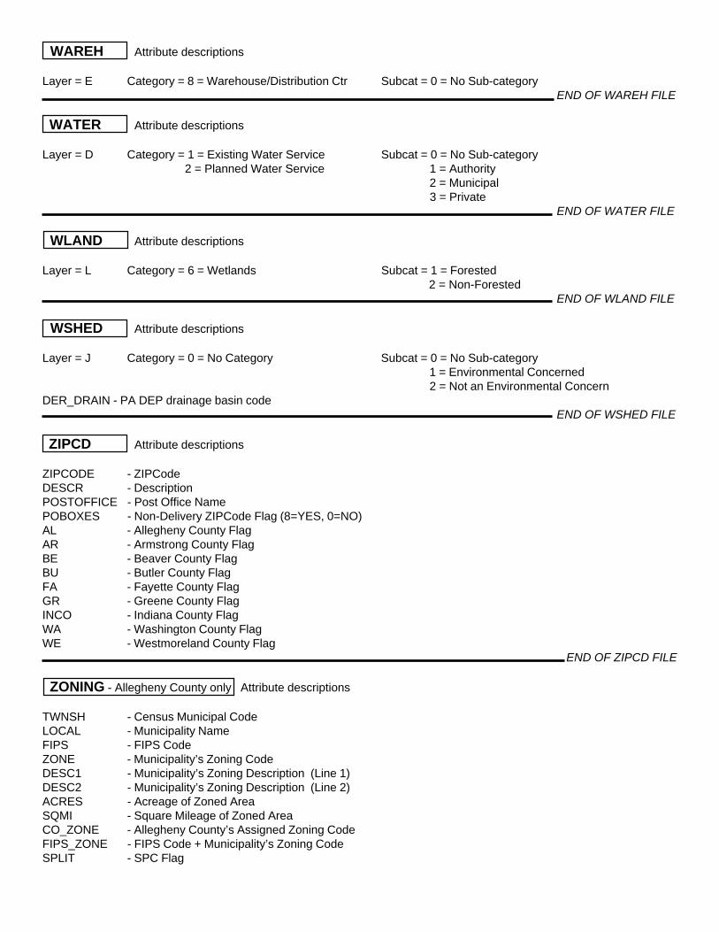
WAREH Attribute descriptions
Layer = E Category = 8 = Warehouse/Distribution Ctr Subcat = 0 = No Sub-category END OF WAREH FILE
WATER Attribute descriptions
Layer = D Category = 1 = Existing Water Service Subcat = 0 = No Sub-category 2 = Planned Water Service 1 = Authority
2 = Municipal 3 = Private
END OF WATER FILE
WLAND Attribute descriptions
Layer = L Category = 6 = Wetlands Subcat = 1 = Forested 2 = Non-Forested
END OF WLAND FILE
WSHED Attribute descriptions
Layer = J Category = 0 = No Category Subcat = 0 = No Sub-category 1 = Environmental Concerned 2 = Not an Environmental Concern
DER_DRAIN - PA DEP drainage basin code END OF WSHED FILE
ZIPCD Attribute descriptions
ZIPCODE - ZIPCodeDESCR - DescriptionPOSTOFFICE - Post Office NamePOBOXES - Non-Delivery ZIPCode Flag (8=YES, 0=NO)AL - Allegheny County FlagAR - Armstrong County FlagBE - Beaver County FlagBU - Butler County FlagFA - Fayette County FlagGR - Greene County FlagINCO - Indiana County FlagWA - Washington County FlagWE - Westmoreland County Flag
END OF ZIPCD FILE
ZONING - Allegheny County only Attribute descriptions
TWNSH - Census Municipal CodeLOCAL - Municipality NameFIPS - FIPS CodeZONE - Municipality’s Zoning CodeDESC1 - Municipality’s Zoning Description (Line 1)DESC2 - Municipality’s Zoning Description (Line 2)ACRES - Acreage of Zoned AreaSQMI - Square Mileage of Zoned AreaCO_ZONE - Allegheny County’s Assigned Zoning CodeFIPS_ZONE - FIPS Code + Municipality’s Zoning CodeSPLIT - SPC Flag

ZONING - Allegheny County only Attribute descriptions ( continued )
NEW_ZNCD - SPC Generalized Zoning Code: AG - Agriculture C-1 - Regional, Office, and Business Commercial C-2 - Neighborhood and Rural Commercial C-R - Mixed Use, Commercial and Residential CBD - Central Business District I - Industrial OSR - Open Space / Reserve PI - Public / Institutional R-1 - Low Density / Estate / Rural Residential R-2 - Medium Density Residential R-3 - Multi-family / High Density Residential RD - Riverfront District RIV - Rivers
END OF ZONING FILE