Embed Size (px)
Citation preview
Elevon Solut ions, LLC
PO Box 1218 Hood River, OR 97031
503-385-5230
www.elevonsolutions.com
+ + + + + + GIS Implementation Model For Small Jurisdictions A Case Study at the City of Hood River, OR
October 18, 2016
GIS Implementation Model for Smaller Jurisdictions: A Case Study at the City of Hood River
TABLE OF CONTENTS
I. EXECUTIVE SUMMARY .............................................................................. 1
II. BACKGROUND ........................................................................................... 2
III. GIS FOUNDATION ..................................................................................... 4 3.1 GEOGRAPHIC INFORMATION SYSTEMS ................................................................................... 4 3.2 GIS PLANNING & IMPLEMENTATION: INDUSTRY STANDARDS OF PRACTICE ....................... 4
3.2.1 Strategic Planning Process .................................................................................................... 4 3.2.2 Funding and Cost Preparation ............................................................................................... 5 3.2.3 Governance, Leadership, Executive Support ........................................................................ 6
IV. PROCESS ................................................................................................... 8 4.1 GOVERNANCE, PARTNERSHIPS AND EXECUTIVE SUPPORT .................................................. 9
4.1.1 Governance and Stakeholder Support .................................................................................. 9 4.1.2 Partner Collaboration and Agreements ................................................................................ 10
4.2 FUNDING MODEL ...................................................................................................................... 11 4.3 EXECUTIVE LEADERSHIP AND PROJECT MANAGEMENT ...................................................... 11 4.4 STRATEGIC ROADMAP ............................................................................................................. 12 4.5 STRATEGIC PLANNING ............................................................................................................. 13 4.6 STAFFING ................................................................................................................................... 15 4.7 DESIGN & CONFIGURATION PROCESS ................................................................................... 17
4.7.1 Data ...................................................................................................................................... 18 4.7.2 Hardware/Software .............................................................................................................. 19 4.7.3 Mobile Hardware/Software .................................................................................................. 21 4.7.4 Workflows and Data Management Processes (Sustainability) ............................................. 22
V. CONCLUSION & NEXT STEPS ................................................................ 24
APPENDIX A ................................................................................................. 25
| 1
GIS Implementation Model for Smaller Jurisdictions: A Case Study at the City of Hood River
I. EXECUTIVE SUMMARY Successful planning and initial implementation of GIS at the City of Hood River flowed from a solid foundation of strategic planning. The planning process and plans resulted from a logical progression of stakeholder and consultant activities and reflections over a six-month period. The most significant activities and plans were:
• Developing a roadmap to guide and communicate the strategic planning
process;
• Conducting in-depth interviews with staff and partners about the current GIS
situation, immediate needs, and future potential uses;
• Conducting a goal-setting and prioritization session with City stakeholders;
• Developing a strategic plan addressing the identified goals and priorities; and
• Developing a draft GIS implementation plan to be expanded on, and adopted. This report describes the planning process and documents the most important results. Best practices, smart ideas, and lessons learned along the way are listed below and highlighted in inset boxes near the relevant text.
• Governance must be led by a decision-making body
• Increase GIS capacity and capabilities through collaborative partnerships
• Take advantage of grants to support initial needs assessment
• Allow sufficient time for stakeholders to participate in the strategic planning
process
• Let shared business needs drive the strategic plan
• Establish metrics to measure progress
• Augment GIS capacity by sharing services and staff
• Use internships to quickly boost staffing
• Seek out existing information regardless of format
• Developing a business case can increase participation and buy-in
| 2
GIS Implementation Model for Smaller Jurisdictions: A Case Study at the City of Hood River
II. BACKGROUND THE CITY OF HOOD RIVER is the county seat of Hood River County. At the heart of the Columbia River Gorge, Hood River is located approximately 60 miles east of Portland Oregon at the confluence of the Hood River and the Columbia River. The City is the northern gateway to the Hood River Valley, and a historically known fruit orchard agricultural center. It is about 30 miles north of Mount Hood, the tallest mountain peak in the state offering year round snow sports, and is just across the Columbia River from White Salmon, Washington, home to progressive industrial development. The City of Hood River Public Works Department, leading this effort, maintains nearly 40 linear miles of City infrastructure to support the growing Hood River community, while promoting public health and safety. The Public Works Department’s responsibilities include the management of streets, parking meters, parks, the sanitary sewer and stormwater collection systems, and the water system. The Public Works staff also operates and maintains City-owned facilities and equipment and supports other City departments. The City’s Public Works program is also the primary source for maintaining the spatial information about the City’s infrastructure. Requests for paper maps to accompany the maintenance of all infrastructure site planning, field work, new development and to support executive-level decision making are satisfied by the Director of Public Works, the single point of contact capable of producing such maps and information. As with many small jurisdictions, the investment in new technologies is a difficult commitment. Investing in unfamiliar technology, which will demand increased staff time to learn and adopt, often forestalls commitments to implementation. The City recognized that having its own GIS technology would improve its efficiency, effectiveness and transparency. Historically, the City developed and maintained the Public Works infrastructure in CAD (Computer Aided Design). A City partner, Hood River County’s GIS department, has been supplying GIS services to the City for many years. That exposure to results from GIS technology contributed to the City’s decision to commit to a more robust geospatial information management system involving migration from CAD to a GIS platform. Following a series of strategic planning activities spanning six months, the City and its stakeholders identified a common vision and a suite of goals. These goals are incorporated into a three-year GIS Strategic Plan that the City’s Public Works Department has adopted and has committed to. Full implementation of GIS as outlined in the plan is now a critical part of their business operations. Dedicated resources, established to implement GIS at the City Public Works Department, enabled the initial

| 3
GIS Implementation Model for Smaller Jurisdictions: A Case Study at the City of Hood River
GIS data development, advanced field data editing capabilities, and enhanced internal and external interoperability--all of which were made possible within one year of adopting the GIS Strategic Plan. This would not have been possible without a strong governance structure and executive-level support.
| 4
GIS Implementation Model for Smaller Jurisdictions: A Case Study at the City of Hood River
III. GIS FOUNDATION
3.1 GEOGRAPHIC INFORMATION SYSTEMS A Geographic Information System (GIS) is a technical tool for organizing geographic data, permitting better understanding of geography and spatial relationships, which ultimately better inform decision making. A GIS allows organizations to better manage their assets, communicate and collaborate, identify patterns, and combine a variety of geographic data in myriad ways. A solid GIS program consists of trained staff and a set of information technology tools that capture, store, manipulate, analyze, manage and present geographically referenced data. Over the past 50 years, GIS has evolved to become a prolific tool for managing and analyzing information, with capabilities to transform the way government agencies conduct business. Wide arrays of professionals rely on GIS technology to improve efficiencies, reduce redundancies, prioritize and plan, and communicate to the public. GIS can enhance the performance of and integrate multiple business systems within organizations, helping meet the demand for greater transparency and faster turnaround.
3.2 GIS PLANNING & IMPLEMENTATION: INDUSTRY STANDARDS OF PRACTICE Often within a public works department, the only sources of information available are construction drawings produced in a Computer Aided Drafting (CAD) system. Shifting from this legacy source to GIS often requires an extensive effort. A well-planned approach can provide significant returns to an organization. This report focuses on the following aspects of planning to implementation of GIS at the City of Hood River: governance, partnerships, executive support, funding, project management, leadership, strategic planning, staffing, and system design and configuration. Three of these components are discussed below.
3.2.1 Strategic Planning Process Strategic planning is a disciplined process, based on an organization’s mission and business needs, for articulating a shared vision, establishing goals, and setting out strategies for achieving those goals. An effective strategic planning process builds organization-wide support needed for investments and adoption, along with moving collaborative programs forward. An implementation plan is key to putting the plan into action, thereby achieving the goals and reaping the benefits.
| 5
GIS Implementation Model for Smaller Jurisdictions: A Case Study at the City of Hood River
The Strategic Plan Guidelines of the Fifty States Initiative (as adopted by the Federal Geographic Data Committee (FGDC) for the NSDI1, sets out three elements for a successful strategic planning process: a roadmap, a strategic plan and an implementation plan. The roadmap helps everyone navigate through the entire strategic planning process. The roadmap divides the process into steps (or phases) that involve specific activities, tasks, and accomplishments. The roadmap helps ensure high-quality and effective strategic and business plans. A strategic plan provides the overall, long-term direction through a common vision, prioritized goals and strategies for meeting the goals. The strategic plan generates a path from the current situation to the envisioned future. The implementation plan furthers the planning process by setting out specific actions and investments to achieve the goals identified in the strategic plan. It typically includes projects and a schedule covering the entire planning period.
3.2.2 Funding and Cost Preparation Adequate funding for the planning, initial implementation, and operating expenses is essential but often elusive. The strategic planning process lays the foundation for budgeting and planning. One of the most compelling actions is conducting a business case. The Geospatial Information & Technology Association (GITA) workbook2, a product of several years of research, presents a straightforward methodology for developing GIS benefit estimates, conducting financial analysis, and preparing a credible return on investment analysis for GIS implementation. Developing start-up and ongoing cost estimates requires care, and the GITA workbook outlines the types of costs to assess in developing a budget.
1 Federal Geographic Data Committee (FGDC). Strategic Plan Guidelines, Produced to Support the Cooperative Agreements Program (CAP), Category 3: Fifty States Initiative. https://www.fgdc.gov/policyandplanning/newspbp/StrategicPlanGuidelines_v2_052809_Fina lVersion.pdf FGDC May 2009. 2 GITA and AWWA. Building a Business Case for Geospatial Information Technology: A Practitioners Guide to Financial and Strategic Analysis. GITA and AWWA, 2007
| 6
GIS Implementation Model for Smaller Jurisdictions: A Case Study at the City of Hood River
One-time costs, such as new hardware, software, data acquisition or conversion, and consulting services, may be capitalized over time. Ongoing costs, such as employee salaries, maintenance fees, training, support services, and data license fees, are funded out of operating budgets. Excluded costs are historical (costs which have already been incurred), such as a prior investment in data development or infrastructure. Internal labor, a significant cost in a GIS program, needs to be considered at the fully burdened rate on an hourly basis. Further financial equations and analysis methodology can be referenced in the GITA workbook. Funding sources include internal streams, joint funding with other partners or programs, and external resources, such as grants. Regardless of the funding source, hardware, software, applications, staffing and maintenance all need to be a part of the annual budget.
Communicating to executives the advantage of investing in GIS is a critical step in the process and often the most difficult to achieve. Citing references, such as the Return On Investment (ROI) analysis from GIS at King County3, can help win their support.
3.2.3 Governance, Leadership, Executive Support
3 Richard Zerbe & Associates. An Analysis of Benefits From the Use of Geographic Information Systems by King County Washington. http://www.kingcounty.gov/operations/%7E/media/operations/it/news_releases/King_County_GIS_3_1_12_Final. Ashx Richard Zerbe & Associates, March 2012.
“Government agency leaders recognize that pre-recession business models are not sustainable, and are willing to pursue radical service changes by making targeted IT investments.
– Gartner, Top 10 Strategic Technology Trends for Smart Government, 2013
“Geospatial information technology (GIT) is a complicated investment. The initial costs can be high, and the tangible benefits can take several years to materialize. Because the early costs of the system are typically high, officials are understandably sensitive to the benefit estimates. They want to be sure the financial analysis is sound.”
– Geospatial Information & Technology Association (GITA), Building a Business Case for Geospatial Information Technology: A Practitioners Guide to Financial and Strategic Analysis, 2007
| 7
GIS Implementation Model for Smaller Jurisdictions: A Case Study at the City of Hood River
Municipalities are finding that relying on outdated business models which were developed twenty--or even ten--years ago are no longer viable. Executives are looking for new technologies to address the increased demand for transparency, accountability and efficiency. GIS is one of these technologies. A fully realized strategic planning process ensures that all shared business needs for GIS are identified. The process of working with executives, stakeholders and partners to create a strategic plan may be more valuable than the actual plans. The intention is to make the process a valuable learning experience that leads to trust and new or renewed partnerships for collaborative action. GIS is an integrative technology and benefits greatly from a genuine collaborative environment. A sustainable municipal GIS, capable of growing and serving an entire City, requires an enterprise approach where the various stakeholders and partners share responsibilities and benefits equitably. GIS is uniquely able to connect interrelated government business and processes in ways that promote more efficient, effective management of public services and infrastructure. For example, when a waterline must be excavated under a street, the GIS clearly indicates other infrastructure in the same location that can be maintained or replaced at the same time. Successful geospatial programs have robust governance structures, diverse partnerships, and sustained executive support. Within this context, organizations expected to coordinate activities, share costs and derive benefits from the GIS program are better engaged in the program’s administration and work better together to achieve results.
| 8
GIS Implementation Model for Smaller Jurisdictions: A Case Study at the City of Hood River
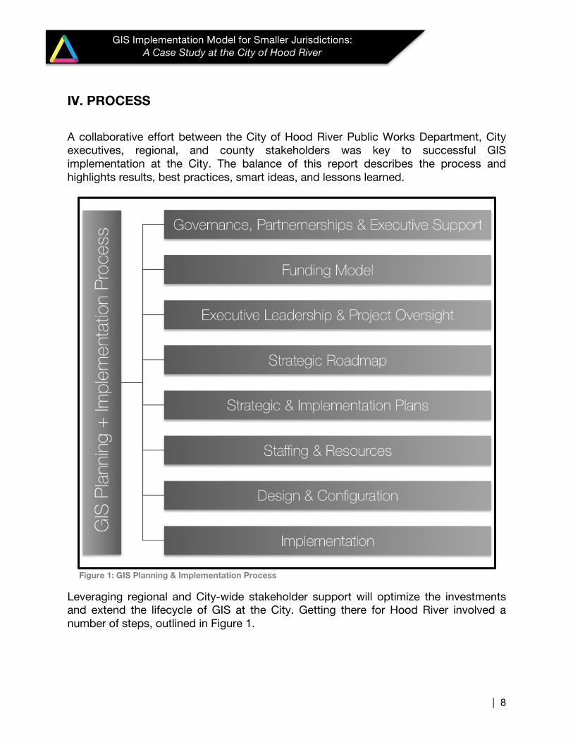
IV. PROCESS A collaborative effort between the City of Hood River Public Works Department, City executives, regional, and county stakeholders was key to successful GIS implementation at the City. The balance of this report describes the process and highlights results, best practices, smart ideas, and lessons learned.
Figure 1: GIS Planning & Implementation Process
Leveraging regional and City-wide stakeholder support will optimize the investments and extend the lifecycle of GIS at the City. Getting there for Hood River involved a number of steps, outlined in Figure 1.
| 9
GIS Implementation Model for Smaller Jurisdictions: A Case Study at the City of Hood River
4.1 GOVERNANCE, PARTNERSHIPS AND EXECUTIVE SUPPORT
4.1.1 Governance and Stakeholder Support The decision to embark on a GIS strategic planning effort at the City of Hood River was initially endorsed by the Director of Public Works. Knowing GIS could provide improved efficiencies and effectiveness and reduce burdens on staff, the Public Works Director was able to convince the City Manager, Planning Director, Fire Chief, and the Hood River County GIS Coordinator to engage in the GIS strategic planning effort and to form a GIS Stakeholder Group. The GIS Stakeholder Group was designed to focus on and integrate the expertise and needs of operational, administrative and technical personnel. The GIS Stakeholder Group at the City of Hood River is a decision-making body because:
• Representatives have authority to make decisions on behalf of their department or locality;
• Representatives are responsible for the management and funding of GIS and thus have sole authority to make decisions about GIS implementation;
• Representatives are responsible for coordination and administrative duties as they relate to information management, which relates directly to the development and implementation of a GIS.
The Stakeholder Group members were selected by the Director of Public Works. The group created its own charter to include the following responsibilities:
• Act as champions for GIS in the organization • Agree on a GIS vision and strategic planning roadmap
“Executive sponsorship and support—Enlightened mayors, County commissioners, City administrators, and tribal leaders don’t leave this important function to chance—they use legislation, ordinances, or Executive orders to establish geospatial programs.”
– National Geospatial Advisory Committee, US Dept. of the Interior
Best Practice A governance body must have decision-making authority
| 10
GIS Implementation Model for Smaller Jurisdictions: A Case Study at the City of Hood River
• Endorse and adopt a GIS strategic plan which includes the following established goals:
o Increase the value of the City’s geospatial data o Be proactive users of GIS technology o Promote effective partnerships and collaboration o Help prioritize and make recommendations for the implementation of GIS o Collaborate, endorse and contribute to the GIS Implementation funding
model o Collaborate on GIS implementation and data development activities
4.1.2 Partner Collaboration and Agreements Demand for geospatial information at the City has steadily increased over time. Without the internal capacity available, it has become difficult for the City to respond to increasingly higher demand for services. Demands on the City have required a proactive approach in developing an open and interactive information-driven environment. As both a provider and a consumer of data and services, the City has needed to expand its GIS capacity for two reasons:
• To establish internal geospatial capabilities for better response to information needs and requests, and;
• To collaborate with the encompassing County of Hood River and other external partners in exchanging and managing geospatial information.
In an environment where resources are minimal and demand for services is high, partnering and collaboration is an ideal solution. For nearly a decade, the City’s GIS needs were supplied by the County’s GIS department. This approach helped the City gradually progress toward their own GIS, while maintaining shared resources and information. Formal agreements are beneficial, and at times required, when sharing resources between jurisdictions and agencies. The City and the County primarily rely on informal agreements for GIS resources. An outdated memorandum of understanding (MOU) was discovered prior to the City’s commitment to GIS Implementation during the preliminary needs assessment and identified as a weakness in the formation of the City-County partnership.
Smart Ideas Increase GIS capacity and capabilities through collaborative partnerships.
Documenting partnerships helps assure continuity.
| 11
GIS Implementation Model for Smaller Jurisdictions: A Case Study at the City of Hood River
Other regional partners include private, public, tribal and nonprofit organizations, such as the Columbia Gorge Community College, Columbia Gorge Commission, Friends of the Columbia Gorge, Warm Springs Tribe, various utility and wind energy corporations, commercial developers, recreation companies (such as Mount Hood Meadows ski resort), and neighboring counties such as Wasco, Multnomah, and Skamania (WA). It will become increasingly important to share information across programs and organizations. Formalized agreements and interoperable GIS technologies can serve as supportive vehicles to sustain the partnership model and enhance the quality of data sharing among them.
4.2 FUNDING MODEL Grant funding came from the State of Oregon’s Geospatial Enterprise Office and the Oregon Department of Transportation. Internal funding was provided by the Public Works Department. These flows supported the planning process and initial implementation. Following adoption of the GIS Strategic Plan, the Public Works Department funded the first phases of implementation, including the purchase of software and hardware, data development, field and desktop viewer configuration, automated workflows and staff training. Funding opportunities were identified early on and resulted in shared GIS resources and services between Hood River County and the City’s Public Works Department. This sharing made implementation viable for a City the size of Hood River.
4.3 EXECUTIVE LEADERSHIP AND PROJECT MANAGEMENT Leadership from the Director of Public Works, along with support from the City Manager and the City Planner, forged a collaborative approach. Establishing a vision and common goals, along with needs-based prioritizations with stakeholders were paramount for gaining leadership support and commitment in seeing through the GIS
Getting Started Grant funding can support an initial GIS needs assessment to determine next steps. Identifying grant opportunities early on allowed the City to understand the technology needs and investments required to fully commit to implementing a GIS.
| 12
GIS Implementation Model for Smaller Jurisdictions: A Case Study at the City of Hood River
efforts from planning to implementation. The Director of Public Works continues to serve as the champion of GIS at the City. Project Management is provided by a contractor and spans the planning process and initial and ongoing implementation projects. The project management role was essential to coordinating stakeholder participation and ensuring timely delivery of services from contractors and City partners.
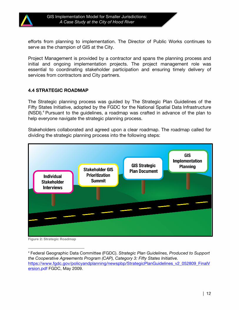
4.4 STRATEGIC ROADMAP The Strategic planning process was guided by The Strategic Plan Guidelines of the Fifty States Initiative, adopted by the FGDC for the National Spatial Data Infrastructure (NSDI).4 Pursuant to the guidelines, a roadmap was crafted in advance of the plan to help everyone navigate the strategic planning process. Stakeholders collaborated and agreed upon a clear roadmap. The roadmap called for dividing the strategic planning process into the following steps:
Figure 2: Strategic Roadmap
4 Federal Geographic Data Committee (FGDC). Strategic Plan Guidelines, Produced to Support the Cooperative Agreements Program (CAP), Category 3: Fifty States Initiative. https://www.fgdc.gov/policyandplanning/newspbp/StrategicPlanGuidelines_v2_052809_FinalVersion.pdf FGDC, May 2009.
| 13
GIS Implementation Model for Smaller Jurisdictions: A Case Study at the City of Hood River
The typical timeframe to complete the strategic planning process, excluding the actual GIS implementation, is four to eight months5. At the City of Hood River, the Strategic planning Process spanned approximately six months.
4.5 STRATEGIC PLANNING The key to effective strategic planning is to identify the business needs of multiple stakeholder groups that can be supported by shared geospatial data and services. The strategic planning process ensured identification of all shared business needs for GIS at the City and its Stakeholders. The first step was to understand the organizational fabric--the business connections between departments and their business partners--and then to understand how the application of GIS technology could benefit those connections. With visibility into these connections, the City was able to plan the GIS implementation to meet short-term and longer-term goals. As a result, GIS at the City will be more resilient to changes in staffing, leadership and resources. The next step was assessing the current state of GIS at the City to provide the baseline for planning. To gather the necessary information, the consultant conducted a series of individual interviews with City and county stakeholders. The interviews not only provided information about the current situation and a description of the individual department or organization business processes, but also ensured that GIS objectives were linked to multi-organizational GIS needs. The major themes resulting from the interviews fell into three categories:
• Data • Technology • Organization
5 Tomlinson, Roger F . Thinking about GIS: Geographic Information System Planning for Managers ESRI Press, 2007.
Lesson Learned Plan for sufficient time and commitment to participate in the strategic planning process. To reduce the time burden, while still providing the opportunity for participation, the City chose to engage stakeholders at three points during the strategic planning process: kickoff meeting, goals and initiatives prioritization session, and final implementation demonstration.
| 14
GIS Implementation Model for Smaller Jurisdictions: A Case Study at the City of Hood River
The outcomes derived from the interviews, defined as strengths, weaknesses, opportunities and threats, were reviewed and prioritized among the stakeholder group during a GIS strategic planning summit session. The summit was held at the City of Hood River City Hall and provided an opportunity for GIS stakeholders to participate in a series of focused discussions concerning the current status and envisioned future of GIS at the City of Hood River. The desired outcomes of the summit were a set of goals focusing on strengthening the weaknesses and leveraging the opportunities, while eliminating or at least minimizing the threats. Facilitators at the summit recorded the prevalent Stakeholder perspectives about GIS strengths, weaknesses, opportunities, and threats and gathered feedback about the City’s GIS needs. Votes were cast for the perspectives and then prioritized in the categories of organizational, technical and data-related issues. The highest concerns were clearly evident. The highest priorities were:
• Data Sharing (inter-departmental, cross-jurisdiction, cross-utility/line of business)
• Data Quality (redundancy, format, location) • Data Access (uniform platform, web-browser, desktop, mobile devices) • Information system integration (County – City/Public Works – Public Safety) • GIS Training and Education (Citywide) • Staffing
The themes garnering the most votes led to establishing the following goals:
• GOAL 1: Increase the value of the City’s Geospatial Data
• GOAL 2: Be Proactive Users of GIS Technology
• GOAL 3: Promote Effective Partnerships and Collaboration
In the next phase of the strategic planning process, implementation planning, the City
Best Practice Shared business needs should drive the strategic plan. Understanding the organizational fabric and interdepartmental business needs was essential to plan for a scalable, interoperable GIS.
Best Practice Establish metrics to measure success. The City uses the Implementation plan to track and measure progress. The metrics can be used to compare with other GIS implementations.
| 15
GIS Implementation Model for Smaller Jurisdictions: A Case Study at the City of Hood River
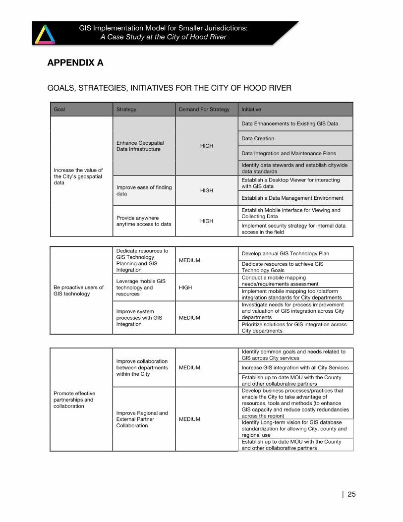
prioritized and determined which initiatives to target for completion and identified specific measures for evaluating progress on the selected initiatives – including timelines and reporting processes. The table in Appendix A summarizes a set of supportive initiatives for each strategy and goal, expanded upon from the Strategic Plan.
4.6 STAFFING
Although the City’s Public Works department successfully manages and maintains the City’s infrastructure with just a few staff, the program is understaffed and under-resourced in the face of increasing demands. Budgeting for staff had not included GIS until the outcomes of the strategic planning process identified the need. The City has relied on Hood River County’s GIS program to provide GIS products and services over the past decade. Demand has outgrown this external support and the County GIS Coordinator can no longer meet the demand. Notwithstanding earnest effort, the County has not been able to respond to the City’s requests in a timely manner, which has been taxing on both organizations. Not surprisingly, a thread—and identified weakness--running through many of the City’s strategic planning discussions related to the lack of GIS capacity. As a result, the strategic plan recommends establishing a shared GIS staffing resource or sharing the cost of services by the County and the City. If implemented, the strategy will reduce costly data redundancies and increase data sharing and use, which in turn will increase the value and benefit of the GIS investments.
“The key element in a successful GIS implementation is the continuing availability of trained staff. This point cannot be overemphasized. The best choices of hardware and software will yield little if the staff is inadequate or untrained. Investments in staff are as crucial as those in any other part of the system.”
- Roger Tomlinson, 2007
Smart Idea Shared services and staffing are cost-efficient ways to augment GIS capacity. ‘Shared services’ is when two or more organizations agree to share resources, which could be staff, hardware and/or software, in order to create benefit for participants.
| 16
GIS Implementation Model for Smaller Jurisdictions: A Case Study at the City of Hood River
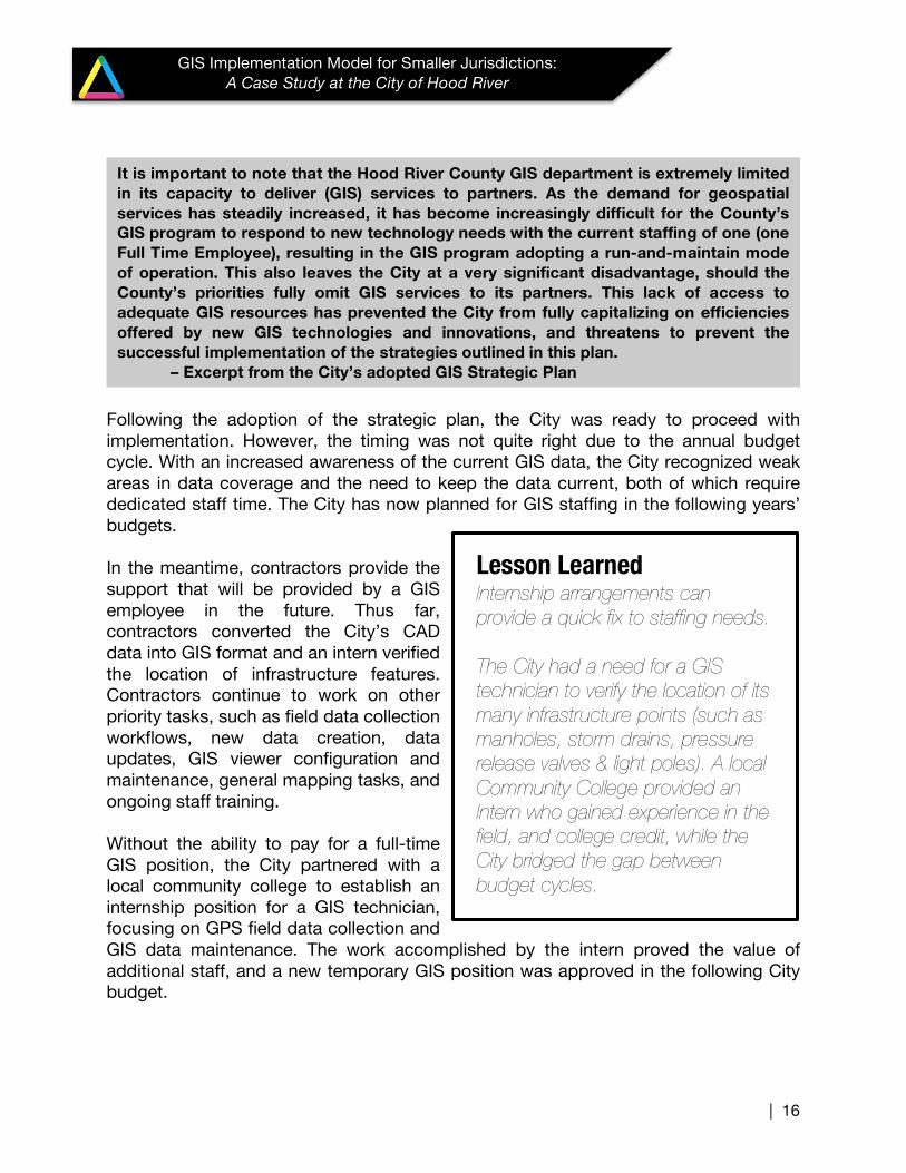
Following the adoption of the strategic plan, the City was ready to proceed with implementation. However, the timing was not quite right due to the annual budget cycle. With an increased awareness of the current GIS data, the City recognized weak areas in data coverage and the need to keep the data current, both of which require dedicated staff time. The City has now planned for GIS staffing in the following years’ budgets. In the meantime, contractors provide the support that will be provided by a GIS employee in the future. Thus far, contractors converted the City’s CAD data into GIS format and an intern verified the location of infrastructure features. Contractors continue to work on other priority tasks, such as field data collection workflows, new data creation, data updates, GIS viewer configuration and maintenance, general mapping tasks, and ongoing staff training. Without the ability to pay for a full-time GIS position, the City partnered with a local community college to establish an internship position for a GIS technician, focusing on GPS field data collection and GIS data maintenance. The work accomplished by the intern proved the value of additional staff, and a new temporary GIS position was approved in the following City budget.
Lesson Learned Internship arrangements can provide a quick fix to staffing needs. The City had a need for a GIS technician to verify the location of its many infrastructure points (such as manholes, storm drains, pressure release valves & light poles). A local Community College provided an Intern who gained experience in the field, and college credit, while the City bridged the gap between budget cycles.
It is important to note that the Hood River County GIS department is extremely limited in its capacity to deliver (GIS) services to partners. As the demand for geospatial services has steadily increased, it has become increasingly difficult for the County’s GIS program to respond to new technology needs with the current staffing of one (one Full Time Employee), resulting in the GIS program adopting a run-and-maintain mode of operation. This also leaves the City at a very significant disadvantage, should the County’s priorities fully omit GIS services to its partners. This lack of access to adequate GIS resources has prevented the City from fully capitalizing on efficiencies offered by new GIS technologies and innovations, and threatens to prevent the successful implementation of the strategies outlined in this plan.
– Excerpt from the City’s adopted GIS Strategic Plan
| 17
GIS Implementation Model for Smaller Jurisdictions: A Case Study at the City of Hood River
4.7 DESIGN & CONFIGURATION PROCESS Outcomes of the planning process defined and prioritized the City’s business needs. These priorities informed the scheduling and implementation of the following elements that support these needs:
• Data • Hardware & software
o Desktop data viewer o Mobile and field-based capabilities
• Workflows & data management • Training
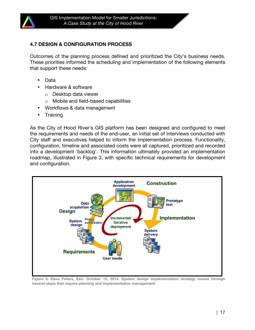
As the City of Hood River’s GIS platform has been designed and configured to meet the requirements and needs of the end-user, an initial set of interviews conducted with City staff and executives helped to inform the implementation process. Functionality, configuration, timeline and associated costs were all captured, prioritized and recorded into a development ‘backlog’. This information ultimately provided an implementation roadmap, illustrated in Figure 3, with specific technical requirements for development and configuration.
Figure 3: Dave Peters, Esri. October 15, 2014. System design implementation strategy moves through several steps that require planning and implementation management
| 18
GIS Implementation Model for Smaller Jurisdictions: A Case Study at the City of Hood River
The following information describes a few of the elements involved in the City’s GIS implementation, all which have helped to build a strong, sustainable foundation to build upon from here forward.
4.7.1 Data The first goal is to increase the value of the City’s geospatial data. The first strategy to achieve this goal is to enhance the existing geospatial data infrastructure.
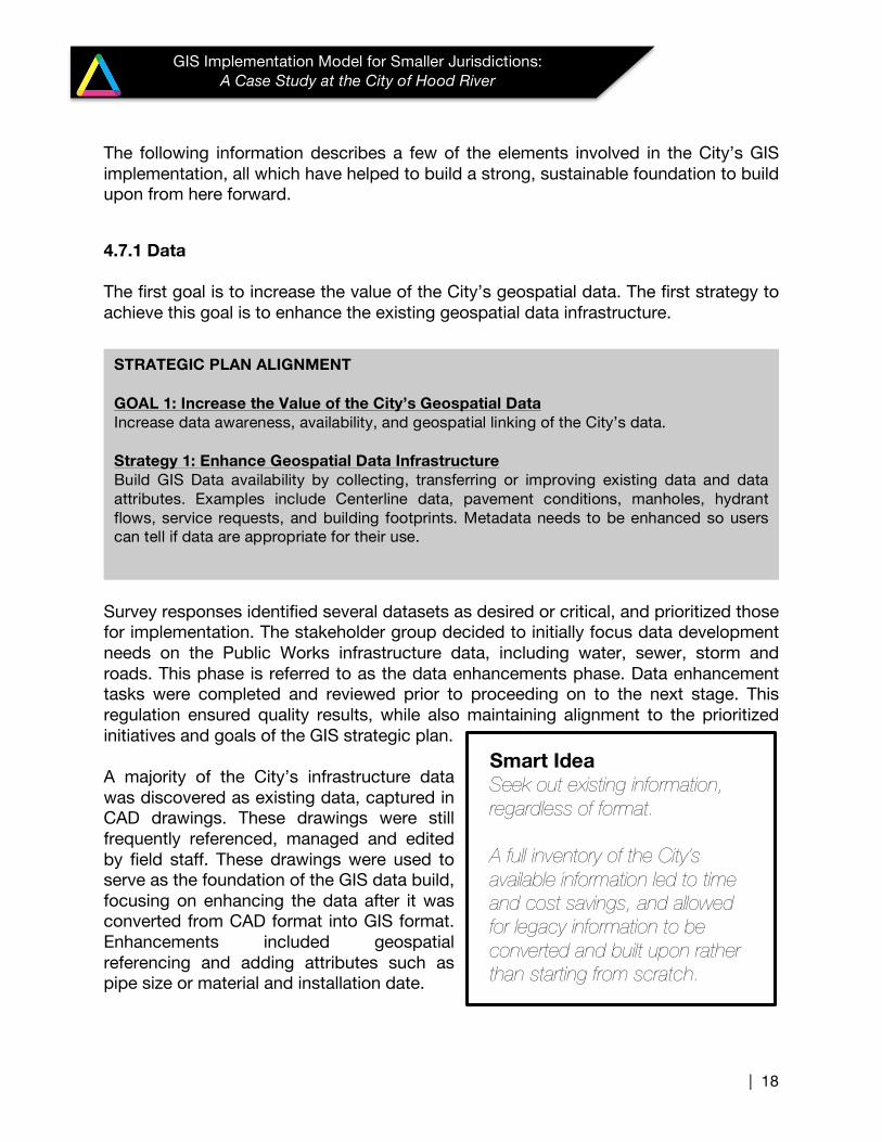
Survey responses identified several datasets as desired or critical, and prioritized those for implementation. The stakeholder group decided to initially focus data development needs on the Public Works infrastructure data, including water, sewer, storm and roads. This phase is referred to as the data enhancements phase. Data enhancement tasks were completed and reviewed prior to proceeding on to the next stage. This regulation ensured quality results, while also maintaining alignment to the prioritized initiatives and goals of the GIS strategic plan. A majority of the City’s infrastructure data was discovered as existing data, captured in CAD drawings. These drawings were still frequently referenced, managed and edited by field staff. These drawings were used to serve as the foundation of the GIS data build, focusing on enhancing the data after it was converted from CAD format into GIS format. Enhancements included geospatial referencing and adding attributes such as pipe size or material and installation date.
STRATEGIC PLAN ALIGNMENT GOAL 1: Increase the Value of the City’s Geospatial Data Increase data awareness, availability, and geospatial linking of the City’s data. Strategy 1: Enhance Geospatial Data Infrastructure Build GIS Data availability by collecting, transferring or improving existing data and data attributes. Examples include Centerline data, pavement conditions, manholes, hydrant flows, service requests, and building footprints. Metadata needs to be enhanced so users can tell if data are appropriate for their use.
Smart Idea Seek out existing information, regardless of format. A full inventory of the City’s available information led to time and cost savings, and allowed for legacy information to be converted and built upon rather than starting from scratch.
| 19
GIS Implementation Model for Smaller Jurisdictions: A Case Study at the City of Hood River
Data development continues within the City’s Public Works department as staff and a new Intern collect data in the field using a GPS unit. Automated processes now relieve the burden on staff to manually update the master GIS database. A logical extension of this work is to bring in other departmental data, such as permits or historical buildings, which will increase efficiencies and interoperability among lines of business.
4.7.2 Hardware/Software Continuing to support Goal number one, the following strategies and tasks focus on availability and access to Data, specifically in establishing the Information Technology (IT) infrastructure necessary to support GIS.
Establishing the server, workstation and Internet connection allowed for data sharing between the City, its contractors and the County. This was a critical piece of the IT architecture, as the City and the County currently share the resources necessary to manage, store, update, share and publish GIS data. Design, procurement, installation and configuration of the hardware and software demand a range of financial and resource commitment. The City relied on external GIS consulting for the recommended hardware architecture6, as well as the software and connectivity7. 6 http://www.geo-ceg.org 7 http://www.elevonsolutions.com
STRATEGIC PLAN ALIGNMENT Goal 1, Strategy 2: Improve ease of finding data The inability to locate data quickly and easily results in overburdened resources to respond to data requests, as well as duplications of effort and lost opportunities. The Public Works department needs to develop simple yet robust search tools so that users can quickly determine if the data they need exist, execute simple queries about the data and simply print maps for field use and reporting. Goal 1, Strategy 3: Provide anywhere anytime access to data The ability to access data when needed is important to improving efficiencies within the City as well as communicating with and supporting data use by the public. City GIS data should be available to City workers as well as the public and partners through all City supported devices and networks while maintaining appropriate security as required.
| 20
GIS Implementation Model for Smaller Jurisdictions: A Case Study at the City of Hood River
Esri software was adopted as the City’s GIS platform standard for the following reasons:
• Compliance with State GIS standards • Easy to use, with support available • Lower total cost of ownership8
The following components were also selected in the architecture of the City’s IT infrastructure:
• Workstation/PC Esri ArcGIS for desktop license, plus a new PC with Windows interface for maintaining software licensing and managing data
• Desktop Data Display, Management and Analysis
Esri ArcGIS Desktop Standard platform
• Web-based Data Display/Mapping Interface Latitude Geographics Geocortex solution
• Network
The City and the County had invested in a fiber optic connection to be installed years ago. Not until now has the connection been activated and put into use. This is a simple return on investment that will bring endless efficiencies in data sharing and networking capabilities.
The establishment of a sustainable and simplified, cost-efficient single-server IT architecture is currently ideal for the City because of the limited amount of demand on the system. As time progresses and users become more familiar with GIS, demands will increase for faster, more efficient performance and further improvements to the IT architecture.
8 Northwest Alliance for Computational Science and Engineering, Evaluation of ESRI and Open Source GIS Tools for the Oregon Explorer Framework, June 14, 2010
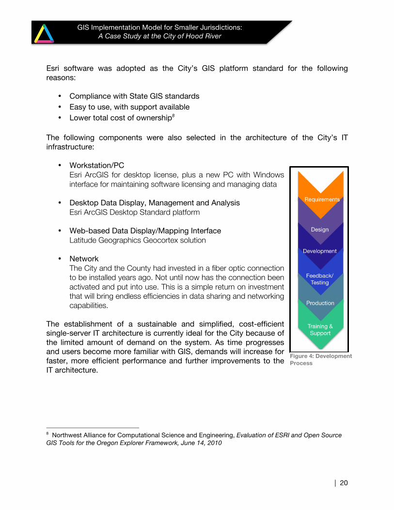
Figure 4: Development Process
| 21
GIS Implementation Model for Smaller Jurisdictions: A Case Study at the City of Hood River
4.7.3 Mobile Hardware/Software Supporting more than one Goal and Strategy, mobile technology development is critical in providing GIS data access in the field, allowing for location verification, data collection and more informed spatial analysis and communication in a mobile environment.
A potentially costly and technically sophisticated component of GIS architecture, the City committed to mobile technology as a short and long-term investment, and adopted a phased approach to implementation. Consulting with subject matter experts (SMEs), recommendations for mobile devices, supportive software and workflows provided the City with the information necessary to make the decision to procure the tools to begin building the infrastructure. The highest priority of the mobile architecture was establishing field data collection and verification tools. The City had a few tablets, a Trimble GPS unit, and mobile phones. Consultants provided the expertise to establish the working connection between the hardware, software and mobile devices, and supporting documentation necessary to train staff on how to use the tools. The first phase focuses on field-based verification of information with the GPS and updating the master GIS dataset. The graphic below, Figure 5, demonstrates one particular field-based verification system that was implemented to improve water meter data.
STRATEGIC PLAN ALIGNMENT GOAL 1: Increase the Value of the City’s Geospatial Data
Strategy 3: Provide anywhere anytime access to data
Goal 2: Be Proactive Users of GIS Technology
Strategy 1: Leverage Mobile GIS Technology and Resources

| 22
GIS Implementation Model for Smaller Jurisdictions: A Case Study at the City of Hood River
Figure 5: Field data collection process
Future phases of mobile technology development include the use of the City’s new web-based GIS application for field use and data updating.
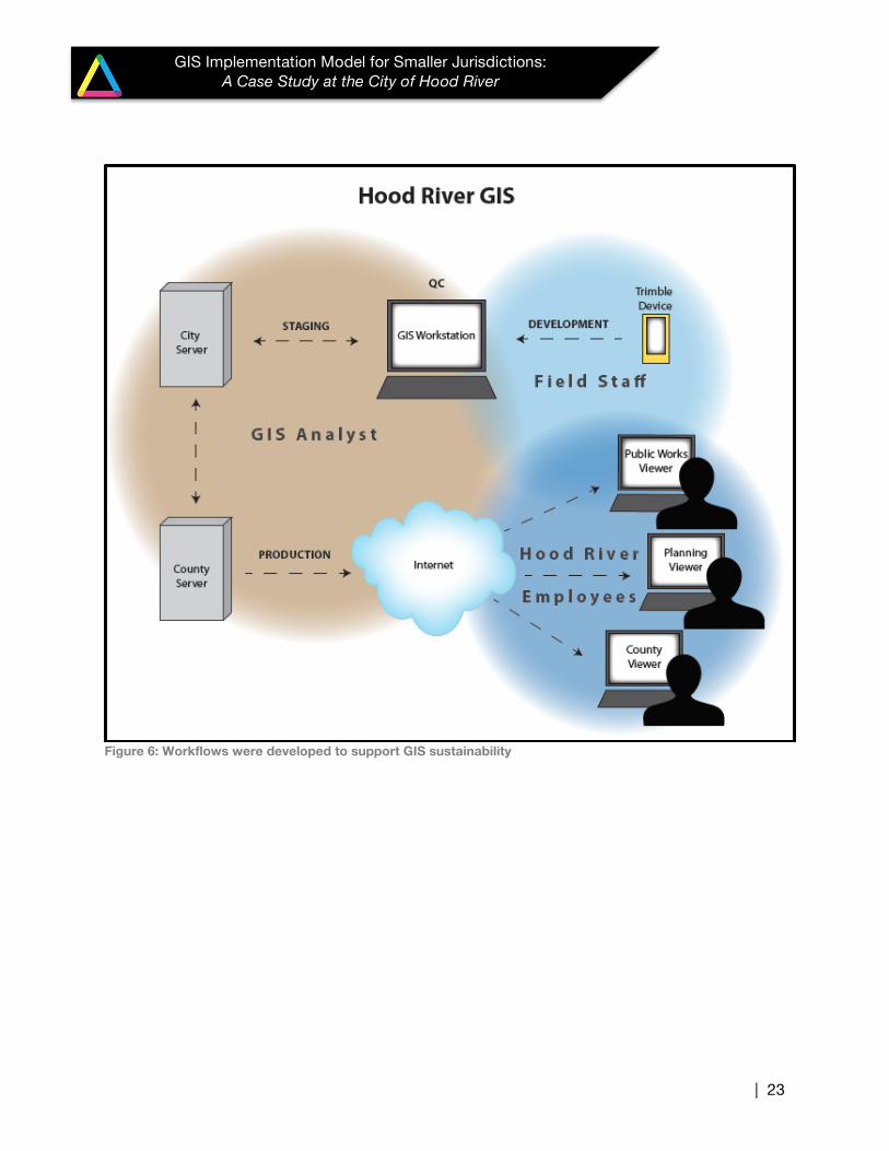
4.7.4 Workflows and Data Management Processes (Sustainability) Supporting Goal 1 in the strategic plan, sustainable data management practices are essential for maintaining the City’s GIS and avoiding the potential loss of value in this substantial investment. To assist in maintaining and better managing the data, workflows and scripted routines were developed for the City. This eliminated the excess burden on staff and also streamlined the data management processes between lines of business. One new workflow, illustrated in Figure 6, allowed for an intern to collect hydrant locations in the field with a GPS unit, update the existing database in the office by reconciling the database after hours (to eliminate potential disruption during working hours), and publishing into the GIS viewer so that staff has access to the latest data the next business day.
| 23
GIS Implementation Model for Smaller Jurisdictions: A Case Study at the City of Hood River
Figure 6: Workflows were developed to support GIS sustainability
| 24
GIS Implementation Model for Smaller Jurisdictions: A Case Study at the City of Hood River
V. CONCLUSION & NEXT STEPS Despite significant challenges, some of which remain, the City of Hood River has made significant progress toward implementing and sustaining GIS capacity in order to facilitate its business and better serve its citizens and partners, while keeping costs relatively modest. The conduct of the planning process and the plans resulting from it have ensured well-rounded participation, orderly implementation, and a method to assess progress. The next logical steps for the City to consider prioritizing in the GIS implementation process are as follows (some of the steps listed below should have preceded the work already completed):
• Development of a Business Case
• Development of a final Implementation Plan
• Identify an internal Technical Lead to serve as the GIS contact and SME
• Align City and County Software and other technical approaches
| 25
GIS Implementation Model for Smaller Jurisdictions: A Case Study at the City of Hood River
APPENDIX A GOALS, STRATEGIES, INITIATIVES FOR THE CITY OF HOOD RIVER
Goal Strategy Demand For Strategy Initiative
Increase the value of the City’s geospatial data
Enhance Geospatial Data Infrastructure HIGH
Data Enhancements to Existing GIS Data
Data Creation
Data Integration and Maintenance Plans
Identify data stewards and establish citywide data standards
Improve ease of finding data HIGH
Establish a Desktop Viewer for interacting with GIS data
Establish a Data Management Environment
Provide anywhere anytime access to data HIGH
Establish Mobile Interface for Viewing and Collecting Data
Implement security strategy for internal data access in the field
Be proactive users of GIS technology
Dedicate resources to GIS Technology Planning and GIS Integration
MEDIUM Develop annual GIS Technology Plan
Dedicate resources to achieve GIS Technology Goals
Leverage mobile GIS technology and resources
HIGH
Conduct a mobile mapping needs/requirements assessment Implement mobile mapping tool/platform integration standards for City departments
Improve system processes with GIS Integration
MEDIUM
Investigate needs for process improvement and valuation of GIS integration across City departments Prioritize solutions for GIS integration across City departments
Promote effective partnerships and collaboration
Improve collaboration between departments within the City
MEDIUM
Identify common goals and needs related to GIS across City services
Increase GIS integration with all City Services
Establish up to date MOU with the County and other collaborative partners
Improve Regional and External Partner Collaboration
MEDIUM
Develop business processes/practices that enable the City to take advantage of resources, tools and methods (to enhance GIS capacity and reduce costly redundancies across the region) Identify Long-term vision for GIS database standardization for allowing City, county and regional use Establish up to date MOU with the County and other collaborative partners