Embed Size (px)
Citation preview

GIS Modeling
Class 12: Spatial Data Quality and
Uncertainty
Geography 4203 / 5203

Some Updates - Progress
Reports• Progress reports: 11 & 14 April (instead of
14 & 16 April)
• Class on 16 April: Jeremy
• Class on 18 April: Babs comes for guestlecture
• One-to-One meetings with project leaders:21 & 23 April (instead of 18 & 21 April)
• Final presentations : 23, 25, 28 & 30 April(as planned)

Last Lecture
• We finished with the very last part of spatialestimation
• We had a look at sampling issues and core areamethods
• You understand why core area delineation is soimportant in different fields for extraction, modelingand evaluation
• You realize how to implement the ideas oftransforming lower-order objects into higher-orderobjects
• You can explain how Kernel methods, convex hulland mean center approaches work

Today‘s Outline
• Coming to aspects of spatial data quality
• Uncertainty and spatial data quality - why are they
important
• See some examples of consequences of
uncertainty in Spatial Data
• Learning more about the terminology used and what
these terms mean
• How to describe quality of spatial data and why
standards have been evolved for transfer standard

Learning Objectives
• Understanding of uncertainty and
spatial data quality as well as some of
the consequences
• Terms and terminology such as
accuracy, error, precision,…
• What the SDTS is and what stands
behind the famous five points

Where to Start…?
• Maybe by asking: What is quality?
- Reaching the best result possible…
- Reaching the requirements defined bystandards or customers…
- Reaching the requirements for a specificapplication -- “Fitness for use”
• In summary this seems to be aboutuncertainty, how it arises and propagatesthroughout the process the spatial data areapplied to

Quality <> Uncertainty???
• Uncertainty is considered to embrace the unknown
domain how good our data are (too many types and
subtypes to be listed here)
• However uncertainty influences our spatial data
quality (question how this quality is specified)
• Uncertainty can be introduced at any stage of GIS-
based map production and analysis (Reality
observation, conceptual modeling, measurement,
analysis steps, and … are we missing one here?)

Any Differences?
• Remember our readings discussion about
uncertainty and SDQ
• Both fields are dedicated to related issues but
went into different directions with regard to
research foci…
• However we will explore the role of
uncertainty and how it influences SDQ during
this class set

Some examples…
• Let’s look at some examples how
important uncertainty can be
• What are the potential (or real)
consequences of decisions based on
uncertain data sources?
• Keep in mind how SDQ can be
specified
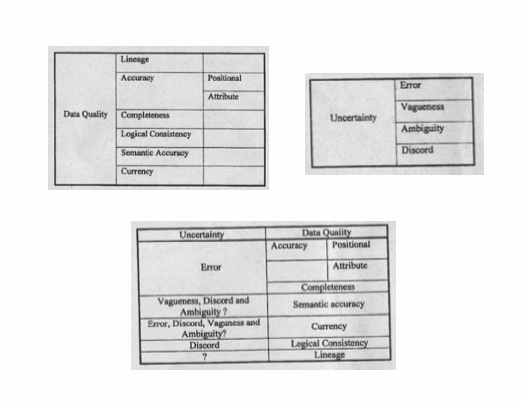
How reliable is catchment
delineation from topographic maps?
• What could be the consequences of
unreliability in these boundaries??
from http://www.ncgia.ucsb.edu/conf/SANTA_FE_CD-ROM/sf_papers/miller1_david/miller_paper1.html

How reliable are estimations
of land cover changes?• Example
Switzerland: “During
the last 100 years
the forest cover
increased by ca.
30%!!!”
• Wow! But here’s the
truth: We don’t know.

How reliable are estimations
of land cover changes?
• Forest definitions in different time periods
• Drivers of forest mapping and political interests
as well as conflicts (serious ones…)
• Practice of mapping in the 19th century
• What are the materials available to get evidence?

How to Approach & Apply
Historical Spatial Data?
• … if you want to use them for GIS
based change analysis…

Representing “on-the-
ground” information
• How often is a value wrong (classifiedfor categorical data)?
• Numbers (average error…) or errordistributions…
• How do we “conceptualize” features?
• What is the collection method?
• What do we misunderstand?
• How much up-to-date are the data?

So where Comes
Uncertainty from?• Limitation in the data (raster
cell’s resolution)
• Mixed categories andhomogenuous value of araster cell (“loosing smallfractions”):inclusion/generalization
• Gradual changes withintransition zones
• Collection, mapproduction, processing
• Non-tracked changes inland cover/ vegetation

Just Using Certain Data?
• There is no perfect data
• We have to be aware of uncertainty associated with
the data, the underlying meaning, the processing
steps to be carried out and the planned application
(fit for use?)
• For this reason it is so fundamental to know more
about uncertainty and its influence to SDQ
• Find some direction within the term clouds, first! We’ll
start with uncertainty and come to SDQ then
• Time for some definitions…

Definitions -- Uncertainty
• … doubt about the information which isrecorded at a location (Fisher 2003)
• … a measure of the difference between thedata and the meaning attached to the databy the current user Zhang and Goodchild(2002)
• … the result of error, ambiguity, vaguenessor lack of information (Fisher 1999,Atkinson and Foody 2002) --> an umbrellaterm for these concepts

Uncertainty
• Fisher 1999
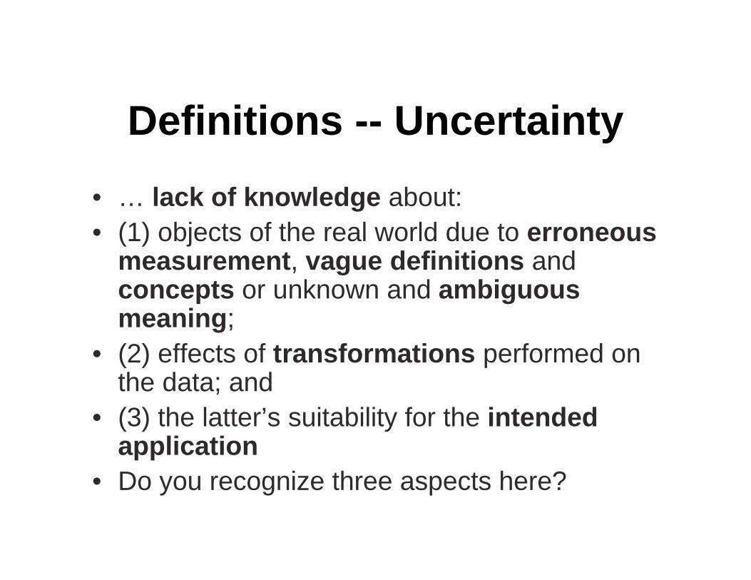
Definitions -- Uncertainty
• … lack of knowledge about:
• (1) objects of the real world due to erroneousmeasurement, vague definitions andconcepts or unknown and ambiguousmeaning;
• (2) effects of transformations performed onthe data; and
• (3) the latter’s suitability for the intendedapplication
• Do you recognize three aspects here?

Definitions -- Error
• Error:
• Difference between a computed, observed ormeasured value or condition and the true, specifiedor theoretically correct value or condition (OxfordReference Online 1996)
• describes the deviation of a value from truth (Jones1997)
• Inaccuracy in cases of systematic error andImprecision in cases of random errors
• Describing cases of measurable deviation from thetrue state where no problems of definition occur.

Definitions --
Accuracy & PrecisionAccuracy:
Difference between arecorded value and itstrue value (often dividedinto spatial, topologicaland attribute accuracy). Inpractice truth is areference value, which isassumed to be moreaccurate
Systematic error
Precision:
Detail with which a
measurement is reported -
there is no point reporting a
measurement to a higher
precision than that with
which it is measured
How repeatable is a
process or measurement?
Random error

Precision & Accuracy

Vagueness
• Indeterminacy due to a lack ofdistinctness between ill-defined or fuzzyclasses of objects or individual objects.
• In GIS vagueness in definition causesdoubt over the membership of aconsidered location to one class orseveral classes
• Sorites paradox (Williamson 1994) °ree of truth
• (a) property of objects, (b) purelylinguistic, (c) epistemic in nature or (d)purely semantic

Vagueness
from hioline.osu.edu/b915/part_one.html
from www.nwhi.org/index/habdescriptions
from http://www.iit.nrc.ca/IR_public/fuzzy/fuzzyJDocs/overview.html\

(from Fisher et al., 2004)

Ambiguity
• Confusion among concepts which have thesame name, but more than one definition(Fisher 2000)
• Discord: lack of agreement if one object isclearly defined but is shown to be a memberof different classes under differingclassification schemes or interpretations
• Non-specificity: Occurrence of ambiguity ifthe assignment of an object to a class isunsettled at all (it is then a matter ofinterpretation and prone to subjectivity)

from http://www.cartoonstock.com/lowres/jfa0432l.jpg

A “Bringing-Together”
• Error is not due to problems of definition butdue to measurable deviations from “truth”
• Vagueness arises due to overlappingdefinitions and is thus only considerable inthe context of an environment with otherobjects or classes of objects
• Ambiguity is caused by definitions withdifferent meaning under varying classificationschemes (discord) or weak definitions (non-specificity) without consideration of itsenvironment

Reporting Data Quality
• Data are passed around and manipulated bymany people, within and betweenorganizations, intentionally andunintentionally
• By reporting on data quality andunderstanding these concepts, we canminimize uncertainty or choose moreappropriate products
• Burrough and McDonnell list factors affectingdata quality...

Where we started…?
• … by asking: What is quality?
- Reaching the best result possible…
- Reaching the requirements defined by standardsor customers…
- Reaching the requirements for a specificapplication -- “Fitness for use”
• In summary this seems to be about uncertainty, howit arises and propagates throughout the process thespatial data are applied to

SDTS
• Developed in the US to allow transfer ofdata between organizations using a definedand agreed standard
• Spatial Data Transfer Standard (SDTS1992) is obligatory for US FederalOrganisations to use the SDTS
• Included compulsory data quality fields(note these are only a small part of Burroughand McDonnell’s list of factors affecting dataquality)

The SDTS famous Five
• Positional accuracy: e.g. the accuracy with which thepositions of depth soundings were reported
• Attribute accuracy: e.g. the accuracy of the actual depthsoundings; the classification of a pixel which is bog asurban area
• Logical consistency: e.g. are values valid (is there aclass called “bag”, are there topological problems (e.g.overlapping polygons with different classes)
• Completeness: e.g. Has a polygon not been digitized,what was the minimum size of object included, what wasthe density of observation?
• Lineage: Who produced the data, what methods did theyuse, why were the data produced, when?


The Famous Five???
• Things change… from SDTS (1992) to…
• Guptill S C and C Morrison J L (eds) 1995 Elementsof Spatial Data Quality.
• So, how to bring them (SDQ, Uncertainty types,Uncertainty domains,…) together now?

Remember…
• Uncertainty is considered toembrace the unknown domainhow good our data are
• However uncertainty influencesour spatial data quality (is ourdata good enough in relationto standards?)
• Uncertainty can be introducedat any stage of GIS-based mapproduction and analysis(Reality observation, conceptualmodeling, measurement,analysis steps, and … use ofthe data)

… where Uncertainty Comes
from…
• The case of historical spatial data:

Metadata…

Summary• Uncertainty and Spatial Data Quality have much in
common, they consider similar topics and have relatedcategories or domains
• Uncertainty embraces the unknown domain to give thebasis for judgments, how good the data are
• SDQ rather allows to ask if our data are good enoughwith regard to standards or expectations
• Uncertainty in Spatial information is still an open researchenvironment due to the many unresolved questionsexisting
• New concepts and methods such as from fuzzy logichave been introduced into uncertainty research
• As you can expect, fitness for use and use error are avery important part for industrial developments of spatialdata technology

References• Burrough, P.A. and McDonnell, R.A. (1998):Principles of Geographical
Information Systems. Second Edition. Oxford University Press.
• Jones, C.B. (1997): Geographical Information Systems and ComputerCartography. Longman.
• Longley et al. 2001. Geographic Information Systems and Science. Wiley.
• Fisher P 1999 Models of uncertainty in spatial data. In Longley P, GoodchildM F, Maguire D J, and Rhind D W (eds) Geographical Information Systems:Principles, Techniques, Management and Applications (Volume 1). NewYork, John Wiley and Sons: 191–205
• Fisher P 2003 Data quality and uncertainty: Ships passing in the night! In ShiW, Goodchild M F, and Fisher P (eds) Proceedings of the SecondInternational Symposium on Spatial Data Quality. Hong Kong, Hong KongPolytechnic University: 17–22
• Guptill S C and C Morrison J L (eds) 1995 Elements of Spatial Data Quality.Oxford, Pergamon
• … if you like endless reference lists: Leyk et al., 2005 in TGIS