Embed Size (px)
Citation preview

1
)GIS (
.
.
-
.
.
-
.
Key Words: Geographical Information Systems, Hot Spots, Crime, Crime Map, Software, Urban
:
2
.
.
.
.
.}2{
}3{
-
.
.}25{
.
}12{.
.
.
}19{.
}26{
3
...}8{
GIS
GIS
}20{
. 1 .
GIS
. 1969
.60
.301 )2
(197521981341980
}22{51989
10
}5{.
1980
.
1Brantingham 2Crow 3Abeyie 4Harries 5Sherman
4
GIS
}32{.
.
.
1
""
.GIS
}33{
.
*
GIS2
.
.GIS
.
GIS3
) (}27{.
GIS
1 Geographic Information Systems 2 Coordinate Systems 3 Digital
5
.
GIS
.
.
GIS
.
GIS19801990
.
GIS}17{
.3
.
1
.
}29{ .
.
}5{ .
.
}24{
1Hot Spots

6
}5{
:
(
(
(
.
.
.
.
}12{
...
.
.
""
.
7
1
1990
1995
GIS
. -
Crime Analyst ArcGIS
}31{ 4
.
:
Crime Stat :-
)5.( 2Stac :.
Crime Solve :
.
Hotspots DetectiveCrime Maps .
.
:
*
:
}25{.
1Softwares 2Spatial & Temporal Analysis of Crime
8
* :
.
" -" .
*
:
}10{.
}11{
.
}10{ .
.6
.
...
}11{ .
.
}27{

9
}8{
1 .
.
.
}14{
}19{
}17{ .
.
}25{
}4{.
:
*
.
}13{
)7.(
1Geodatabase
10
*
.
}11{.
)8 .(
*
.
.
}25{
.
*
.
*
}9{.
.
)910(
:
*
.
*
11
.
)
... (
.
*
.
.
.
*
.
.
}10{ .
)11 .(
:
1-
.
2 -
....
3 -
4-)Link (
5-
}19{.
12
GIS
GIS12 3
.
GIS}14{ .
.GIS
}19{ .GIS
:
4
.
}18{ .
1 Descriptive 2 Analytical 3 Interactive 4 Call Services

13
.
1
.
...}6{.
2 3}9{
.
}23{ .4 5:
*
:
.
* :
.
* :
-
}6{.
1 Thematic Maps 2 Processed 3 Database 4Community-Oriented Policing 5Problem-Oriented Policing
14
.
:
*
.
}12{.
}22{ .
GISGPS1
.
*
.
}14{.
...
.
}10{.
.
1 Global Positioning System
15
.
*
1
.
.
}22{.
.
.
*
.
.
.
GIS
.
1 call for service
16
1
.
."2"
GPS
.
GPS}10{.
Compstat3 GIS
.
.
}22{ .
.4
.Compstat
}10{.
1 Command & Control 2 Gazetteer 3Computer & Comparative Statistics 4Intelligent
17
.
}25{ .
.
.
}21{.
)(
.
x
y
.
}25{ .
.
.
.
GIS
}6{.
.
18
.
.
}16{.
.
)GPS(
-
}6{.
.
.
.
.
.
.
19
.GIS
.
GIS
GPS1 )RS(
.
.
¬
)GIS (
.
1 Remote Sensing
20
:
1- )1388(
)GIS (
:
2- )1388(4
5196-185
3- )1383(
30-15
4-
)1387(
:
31-5
5- )1386(
100-75
6- )2006(
:)1386(
7-
Anselin, L., (2003), an Introduction to Point Pattern Analysis using CrimeStat, University of Illinois
8-
C.P. Johnson (2000), Crime Mapping and Analysis Using GIS, Conference on Geomatics in Electronic Governance, pune
9-
Casady, T.,(2008), Automating briefings for police officers IN: Chainey, S., & Tompson, L., (Eds.), Crime Mapping Case Studies: Practice and Research, John Wiley & Sons, 27-35
10-
Chainey, S., & Ratcliffe, J., (2005), GIS and Crime Mapping (Mastering GIS: Technol, Applications & Management series), John Wiley & Sons
21
11-
Chainey, S., Dando, J., (2006), Mapping Crime: Understanding Hot SpotsSpecial Report, U.S. department of justice, office of justice program
12-
Clarke R. V., & Eck, J. E., (2007), Crime Analysis for Problem Solvers in 60 Small Steps, U.S. Department of Justice, and Office of Community Oriented Policing Services (COPS)
13-
Eck, J. E., (2006), Mapping Crime: Understanding Hot Spots, Special Report, U.S. department of justice, office of justice program
14-
ESRI, (2005), Crime Analysis GIS Solutions for Intelligence-Led Policing, IN: www.esri.com/publicsafety
15-
Fazal, S., (2008), GIS Basics, New Age International
16-
Getis, A., & et al (2000), Geographic Information Science and Crime Analysis, URISA Journal, Vol. 12, No. 2, p.7-12
17-
Groff, E., (2008), Simulating crime to inform theory and practice; IN: Chainey, S., & Tompson, L., (Eds.), Crime Mapping Case Studies: Practice and Research Publisher: John Wiley & Sons, 133-143
18-
Hirschfield, A. (2001), Decision support in crime prevention Data analysis, policy evaluation and GIS; IN: Hirschfield A. & Bowers K.(Eds.), Mapping and Analysing Crime Data Lessons from research and practice, Taylor & Francis, 237-268
19-
James L. LeBeau, (2001), Mapping out hazardous space for police work, IN: Hirschfield, A., & Bowers, K., (Eds.), Mapping and Analysing Crime Data Lessons from research and practice, Taylor & Francis, 139-155
20-
Krish, K., (2003), Application of GIS in Crime Analysis and Geographic Profiling, Map India Defence& Internal Security Conference
21-
Lu, Y., (2005), Identifying Hot Link Between Crime and Crime-Related Locations, IN: Wang, F., (Eds.), Geographic information systems and crime analysis, Idea Group, 253-270
22-
Manning, P.K., (2008), The technology of policing: crime mapping, information technology, and the rationality of crime control, New York University Press
23-
Mashford, T., (2008), Methods for implementing crime mapping within a large law enforcement agency: experiences from Victoria, Australia, IN: Chainey, S., & Tompson, L., (Eds.), Crime Mapping Case Studies: Practice and Research, John Wiley & Sons, 19-27
22
24-
McLafferty, S., McGuire, P., Ross, T., Mollenkopf, J., Goldsmith, V., & Quinn, S., (2001), Tools in the spatial analysis of crime Doug Williamson, IN: Hirschfield A. & Bowers, K.,(Eds.), Mapping and Analysing Crime Data Lessons from research and practice, Taylor & Francis:187-202
25-
Oberwittler D., & Wikstr¨om P.H., (2009), Why Small Is Better: Advancing the Study of the Role of Behavioral Contexts in Crime Causation; IN: Weisburd, D., Bernasco, W., & Bruinsma G. J.N, (Eds.), Putting Crime in its Place, Units of Analysis in Geographic Criminology published by springer: 33-61
26-
Overall, C., & Day G., (2008), The Hammer Gang: an exercise in the spatial analysis of an armed robbery series using the probability grid method; IN: Chainey, S., & Tompson, L., (Eds.), Crime Mapping Case Studies: Practice and Research Publisher: John Wiley & Sons, 55-63
27-
Paula Mendes de M., A. & Ferreira, M. (2008), An analytical technique for addressing geographical referencing difficulties and monitoring crimes in Rio de Janeiro, Brazil; IN: Chainey, S. & Tompson L.(Eds.), Crime Mapping Case Studies: Practice and Research, John Wiley & Sons, 9-19
28-
Peed, C., & Wilson, R. E., (2008), Making Smarter Decisions: Connecting Crime Analysis with City Officials, Police Chief, Vol. LXXV, No. 9
29-
Ratcliff, J., & McCullagh, M.,(2001), Crime, repeat victimisation and GIS, IN: Hirschfield, A., & Bowers, K., (Eds.), Mapping and Analysing Crime Data Lessons from research and practice, Taylor & Francis, 61-93
30-
Rose, S.,(2008), Community Safety Mapping Online System: mapping reassurance using survey data, IN: Chainey, S., and Tompson, L.,(Eds.), Crime Mapping Case Studies: Practice and Research, John Wiley & Sons, 93- 103
31-
Scott, L., & Warmerdam, N., (2005), Extend Crime Analysis with ArcGIS Spatial Statistics Tools,IN: http://www.ESRI.com
32-
Spencer, C., & Ratcliffe, J., (2005), GIS and Crime Mapping, John Wiley & Sons
33-
Szakas, J., Trefftz, C., Ramirez, R. & Jefferis, E., (2008), Development of an Intelligent Patrol Routing System Using GIS and Computer Simulations, IN: Liu, L., & Eck, J., (Eds.), Artificial Crime Analysis Systems: Using Computer Simulations and Geographic Information Systems, Information Science, Hershey, New York,339-351
34-
Wang, X., Liu, L., Eck, J., (2008), Crime Simulation Using GIS and Artificial Intelligent Agents, IN: Liu, L., & Eck, J., (Eds.), Artificial Crime Analysis Systems: Using Computer Simulations and Geographic Information Systems, Information Science, Hershey New York, 209-225
23
35-
Weisburd, D., Bernasco, W., & Bruinsma G. J.N., (2009), Units of Analysis in Geographic Criminology: Historical Development, Critical Issues, and Open Questions; IN: Weisburd, D., Bernasco, W., & Bruinsma G. J.N (Eds.), Putting Crime in its Place, Units of Analysis in Geographic Criminology,springer, 3-33
36-
Wilpen L. Gorr, Kristen S. Kurland (2011), GIS Tutorial for Crime Analysis, ESRI Press
:
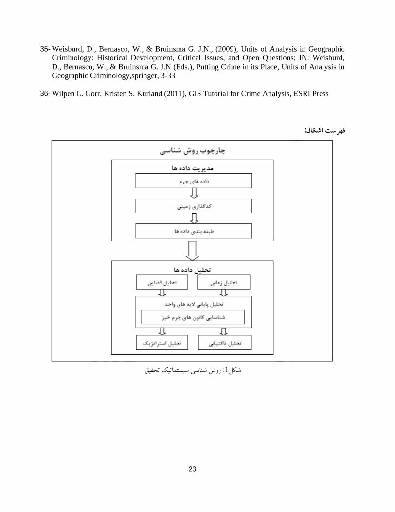
1 :
24
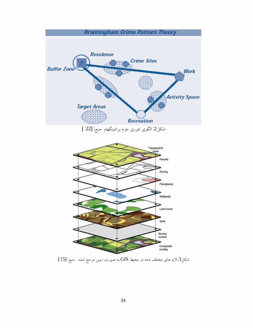
2 ::}22 {
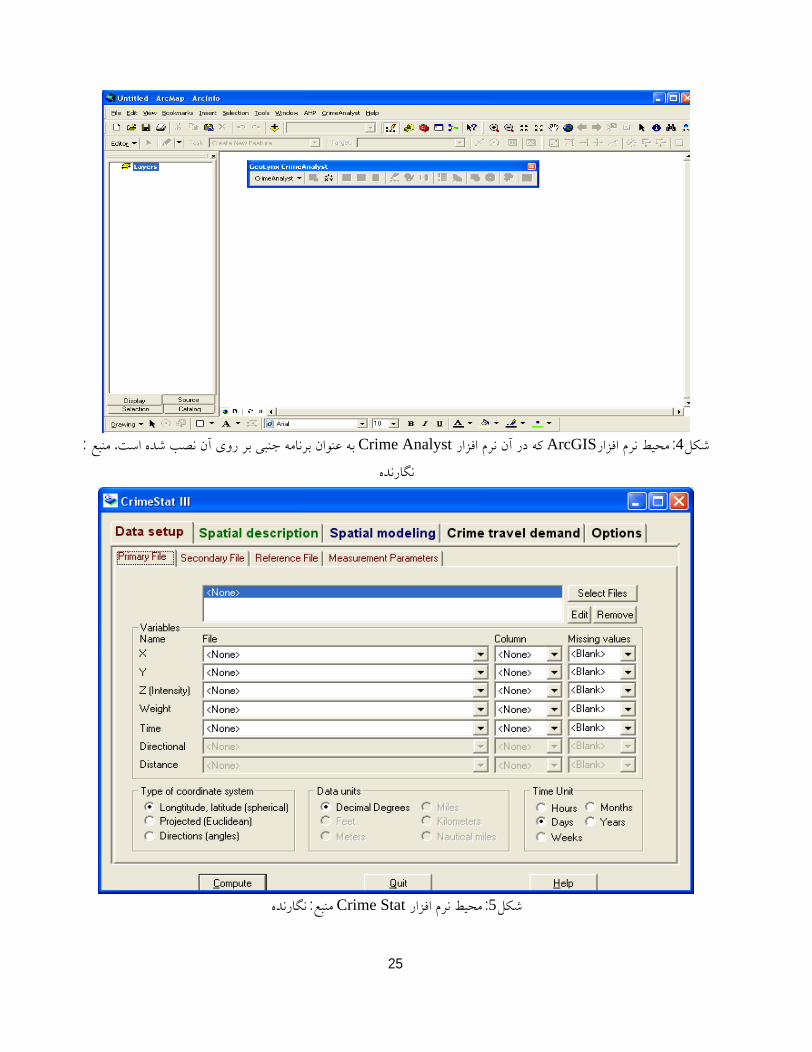
3 :GIS:}15{
25
4 :ArcGIS Crime Analyst. :
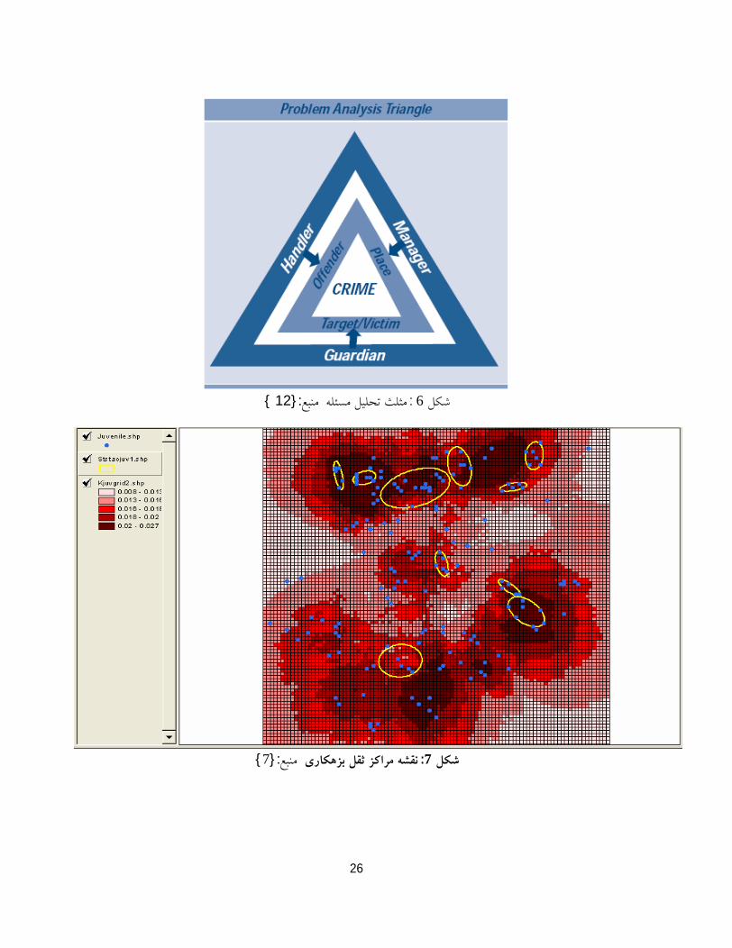
5 :Crime Stat :
26
6 ::}12 {
7 :
:}7{
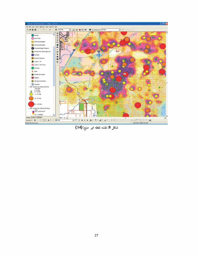
27
8 :
:}14{
28
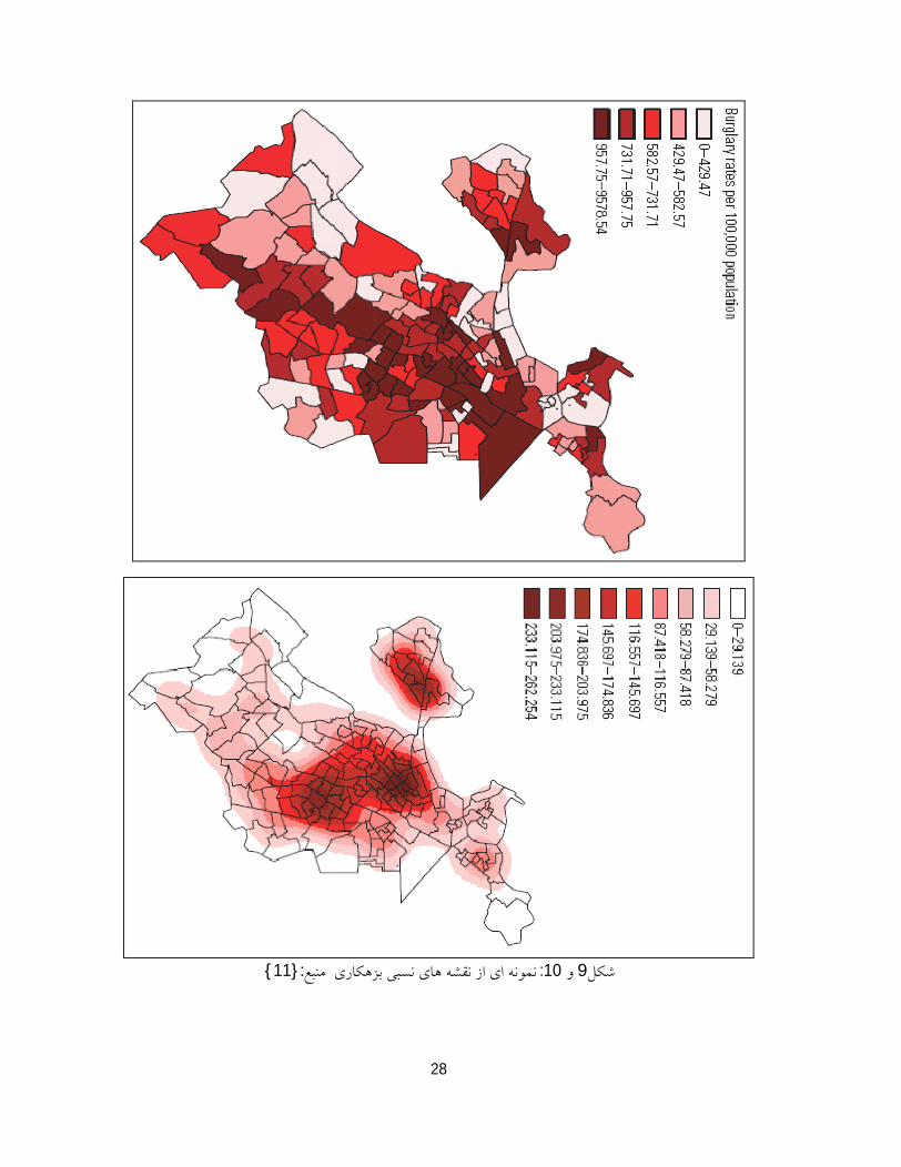
910 :
:}11{
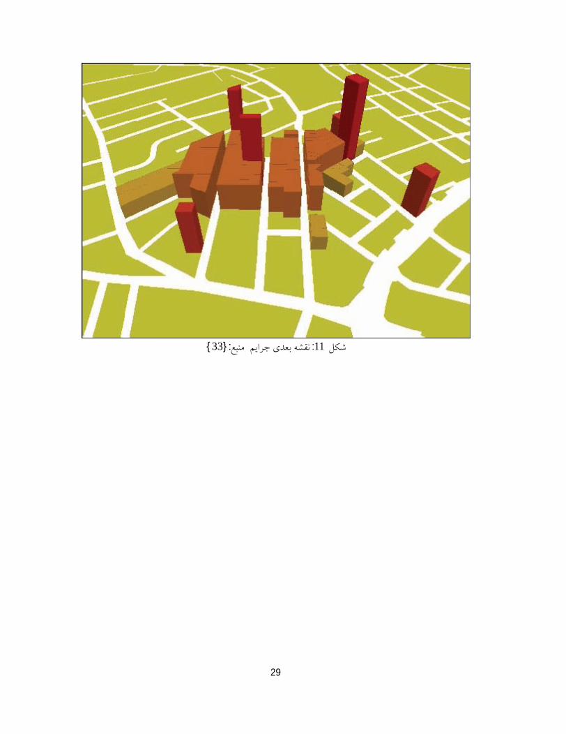
29
11 ::}33{

This document was created with Win2PDF available at http://www.daneprairie.com.The unregistered version of Win2PDF is for evaluation or non-commercial use only.