Embed Size (px)
Citation preview

GIS on Cloud Computing
Ken Leung Assistant GIS Solution Manager

Individual System Server Specific Purpose
Data Management
Planning & Analysis
Field Mobility
Visualization Constituent Engagement
Transform Data Into Actionable
Information
Collect, Organize, & Exchange Data
Get Information Into and Out of
the Field
Disseminate Information Where
and When it is Needed
Get Feedback and Make Informed
Decisions
Existing Market / Situation
• less time to spin up servers and capacity• Easy to set up and administer• Extremely fast release of web maps• Non constraining for innovation• Lowering Cost• Simplicity• Scalability

The Cloud is a Deployment Option
What part of IT is core to your mission critical workflows?
…is GIS part of it?
OnOn--PremisePremise
HostedHosted
Rich Rich ClientsClients
MobileMobile
DesktopDesktop

Elasticity: ”…the tendency of a body to return to its
original shape after it has been stretched or compressed…”
Source: wordnetweb.princeton.edu, and Andy Hendrickson

Elasticity
• Can adjust for peaks and troughs in demand for…• Data Management
• High Availability w/ Web Map Server + EGDB
• Enhanced & Dynamic Processing -- Batch Data Processing, Large Scale Analysis
• Cache cooking / Cache deployment • Geocoding
Data Management
Analysis

Elasticity
• Visualization & Mobile enablement• Grow out capacity as needed• Expand capabilities in near real time• High Availability
Operational Awareness
Mobile
Constituent Engagement

Deployed How You WantAligning with the Maturity Of Your Organization
Complimenting Existing Desktops & Servers
Cloud
Hybrid
On Premises
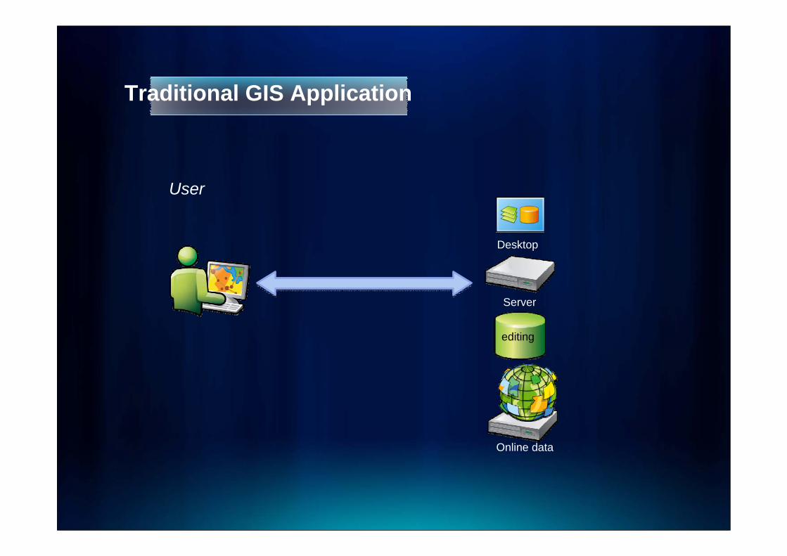
Traditional GIS Application
editing
Server
Desktop
User
Online data

Data Management deployment to Cloud
editing
Server
Desktop
UserPublic
OrPrivate
Online Data

Hybrid Deployment with Redundancy
Server 1
Server n
Server 2
Server 3
editing
Server
Desktop
On-PremiseData Management& Analysis
VisualizationIn Cloud
PublicOr
Private
Online Data

Deployment with redundancy
Server 1
Server n
Server 2
Server 3
On-PremiseUser
Data ManagementData Publication & AnalysisIn Cloud
editing
Server
Desktop
Publication & VisualizationIn Cloud
PublicOr
Private
Online Data

Hybrid Deployment with Redundancy
Server 1
Server n
Server 2
Server 3
editing
Server
Desktop
2-way replication
active active
Server
On-PremiseData Management& Analysis
Publication & VisualizationIn Cloud
Data PublicationIn Cloud
PublicOr
Private
Online Data

Hybrid Deployment with Redundancy
ArcGIS Server 1
ArcGIS Server n
ArcGIS Server 2
ArcGIS Server 3
editing
ArcGIS Server
ArcGIS Desktop
1-way replication
passive active
ArcGIS Server
On-PremiseData Management& Analysis
Publication & VisualizationIn Cloud
Data PublicationIn Cloud
PublicOr
Private
ArcGIS Online

Deployment with Test
Server 1
Server n
Server 2
Server 3
editing
ArcGIS Server
ArcGIS Desktop
2-way replication
active active
ArcGIS Server
On-PremiseData Management& Analysis Test
Server
Online Data
Limit Risk
• Performance & Scalability• The Cloud may not be reliable enough - you need to
evaluate - SLA• Is the the cloud secure enough?• Real Utilization of owned equipment vs. rented

Windows
Apps
Profile
Hardware DynamicallyDelivered Desktop
Delivery• Fewest possible desktop images• Desktop image simplicity• Fewer conflicts, minimized testing• Low-touch, self-serve re-imaging
Profiles
Apps
OS
Virtualized & Isolated
Application Delivery Optimization

Application Delivery Optimization
Compression History
Compression History

Public Map Sharing

Share Map in Different Topics Open data platform for maps and geographic information
• Easily create and share maps • Delivered as intelligent maps• Access on virtually any
device – anyone, anywhere• Compliments and extends the
value of your GIS• Use within an organization or
share with larger communities and/or public
Extend the value and reach of your GIS
GIS for EveryoneEasy / Open / Accessible
IntelligentWeb Maps

Intelligent Maps
Supporting
• Visualization
• Editing
• Popups
• Analysis
• Time
Intelligent Maps
ServicesAnd Data

Upload, Connect and Share
• Open and standards-based• Use and store geospatial info
- GIS datasets and services- OGC web services - WMS- KML & GPX- Spreadsheet data (CSV’s)
• You decide how it is shared- Public/private- Embed in web page or blog- Links & social networks

Interact with Intelligent Maps Anywhere
One Map Desktop
Tablets
Smart Phones
Online Map
Any Device Apps
Browsers

Use Webmaps in Applications
• Custom web pages• Web applications• Stand-alone applications• Client libraries for building
rich GIS applications- Javascript - Flex- Silverlight- REST
• Mobile API’s
Rich ClientRich Client
Web APIWeb API
Web ContentWeb ContentServicesServices
Build rich, interactive apps with mapping and geographic functionality

ExampleArcGIS Explorer Online


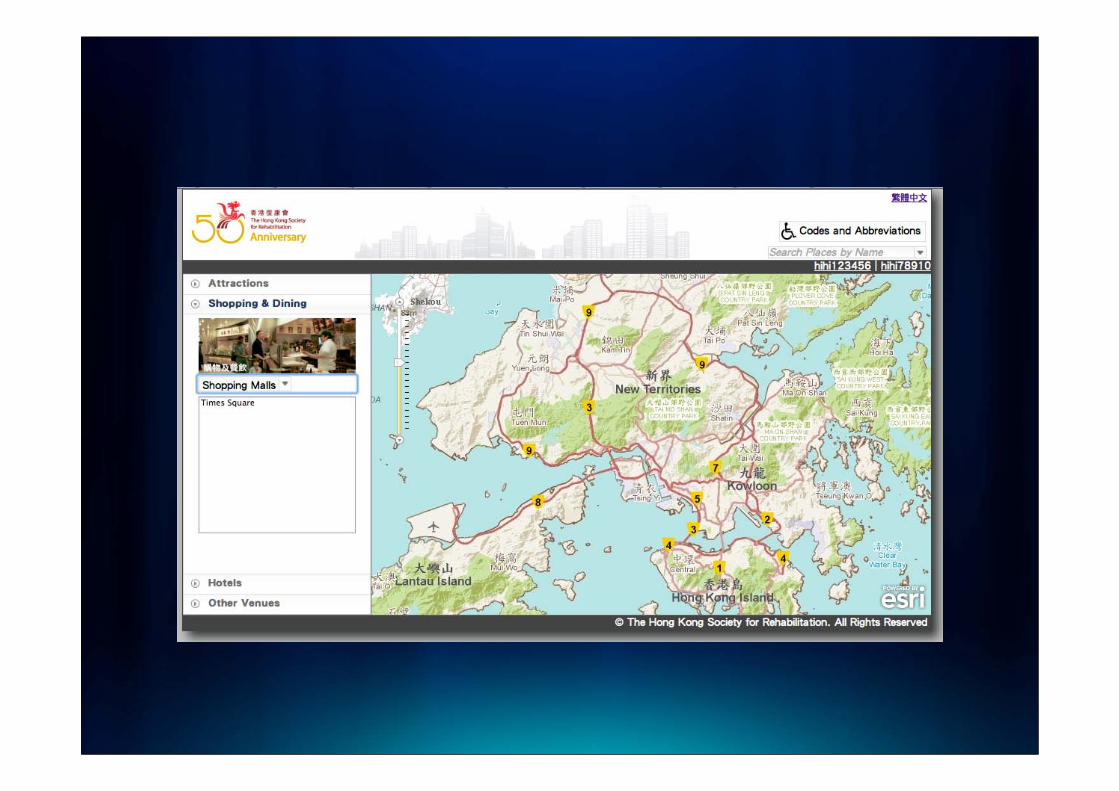
The Hong Kong Society for Rehabilitation Hong Kong Access Guide

Traditional Access Guide Website

List of the Facilities


Q&A