Embed Size (px)
Citation preview

GIS TRAINING
USE OF GIS AND REMOTE SENSING IN PLANNING
PROSPER GASS KEKETSYOR-ILGS

Objective1 Basic concepts Functionalities of GIS Available software (Open
source and closed) Various Tools and Applications Overview of Spatial Information Data Manipulation practice

Overview1 Definition- GIS for lanning Parts of GIS in Planning Functions of GIS in Planning Elements of GIS Spatial Information Systems-
Types Applications of GIS in Planning Users of GIS in Planning Questions GIS can answer

What is GIS?Peter Burrough 1996- “GIS is
a powerful set of tools for storing and retrieving at will, transforming and displaying spatial data from the real world for a particular set of purposes

What is GIS?Clarke 1995- “GIS are
automated systems for the capture, storage, retrieval, analysis and display of spatial data”

What is GIS?Jack Estes and Jeffery Star
1990-“GIS is an information system designed to work with data referenced by spatial or geographic coordinates. In other words, a GIS is both a database system with specific capabilities for spatially-referenced data, as well as a set of operations for working with the data”

What is GIS?Duecker 1979-“A geographic
information system is a special case of information systems where the database consists of observations on spatially distributed features, activities or events, which are definable in space as points, lines, areas. A geographic information system manipulates data about these points, lines and areas to retrieve data for ad hoc queries and analyses”

What is GIS?ESRI (Environmental
Systems Research Institute) 1995- “GIS is a computer system capable of holding and using data describing places on the earth’s surface”

GIS basically has three components namely:
The DatabaseThe spatial or map
informationSomeway to link the two

5 MAIN FUNCTIONS OF A GIS
1. Data Acquisition Data acquisition is the process of identifying and gathering data required for your application.
- Topographic maps- Aerial photography- Satellite images- Field observation- Statistical information- Survey information

5 MAIN FUNCTIONS OF A GIS
2. Data input (processing) Data input involves manipulating the data in several ways so that it may be entered into the GIS.
- Use of GPS-data (input through x, y coordinates)- Digitizing (Vector)- Scanning (raster)- Vectorizing- Aerial photographs (raster)- Satellite data (raster)
The process of extracting information from these data sets and recording the information in a computer database also is a very time consuming effort.

5 MAIN FUNCTIONS OF A GIS
3. Data management- Management of geographic
data sets (vector data, raster data and images e.g. TIFF Files or graphics)
- Storage of data (database), update, deletion and retrieval of data (very important are issues of security-e.g only specific users have access to the system and its databases)
- Project management (overall objectives of project, quality control, database structure, organisation of thematic layers)

5 MAIN FUNCTIONS OF A GIS
4. Data analysis- Tabular analysis using logical
operators- Measurement of area or
perimeter and length- Polygon overlay- Interpolation e.g generation of
DEM’s (calculation of slope, aspect etc)
Generalization of objects

5 MAIN FUNCTIONS OF A GIS
5. Data output Data display is the phase where final
outputs from the GIS are created. These output products might include:- statistical reports (e.g average
population densities for specific areas)
- maps of various kinds (hardcopies)
Data conversion (DXF, ASCII, DEM, EOO, Illustrator, EPS)
- Screen demostrations (ARC/VIEW)
- Graphs and charts displaying data analysis

Spatial Information Systems
Types Three types of spatial information systems can be distinguished.
1. Computer Aided Design (CAD) Graphic systems used by industrial designers, architects
and landscape architects to support and display their work.
2. Land Use Information Systems (LIS) Functions as an administrative system for the
management of geographic data on land use. The central focus is the development of a very detailed database. LIS provides powerful tools for local planning authorities and public infrastructure agencies operating at a very detailed micro scale.
3. Geographic Information System (GIS) GIS tend to support analysis, planning and evaluation at
a more macro scale. They are used to assist the research required to formulate and evaluate central and local government policy with respect to different aspects of physical and environmental planning on the one hand, and economic or strategic planning on the other. The distinguishing feature of GIS in comparison with LIS and CAD is the availability of spatial analytical tools.

Spatial Information Systems
Other Information Systems
1. Space Information Systems A space information system is an instrument for
decision making for planning and development in regional areas. The database contains data of the population, economy and settlement development as well a infrastructure, land use and resource management.
2. Meta Information Systems (LIS) A meta-information system is an information system
about informations. It describes aspects of information processing and availability (which information one can get and where).
3. Environmental Information System (GIS) An expanded geographic information system for
recording, storing, processing and presenting spatial, temporal and subject-related data in order to describe the state of the environment with regard to burdens and hazards and which forms the basis for environmental protection measures.
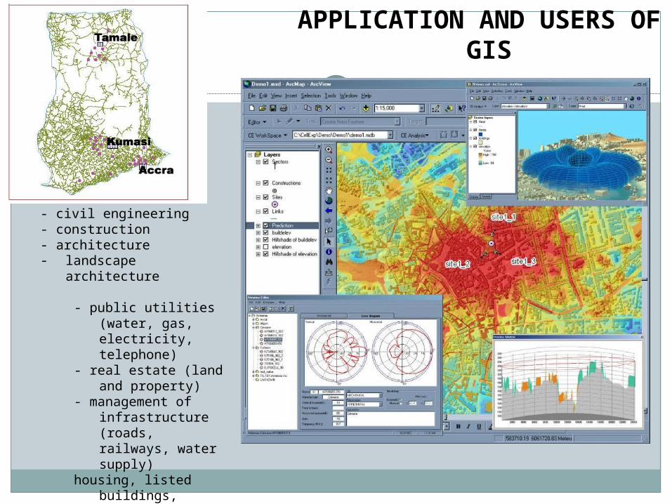
APPLICATION AND USERS OF GIS
- civil engineering- construction- architecture- landscape architecture
- public utilities (water, gas, electricity, telephone)
- real estate (land and property)
- management of infrastructure (roads, railways, water supply)
housing, listed buildings, industry

APPLICATION AND USERS OF GIS
- traffic and transport planning
- agriculture planning- environmental and
natural - - resource management
- recreation planning- location decisions- spatial planning (land
use)- service planning
(education, social services etc..)
- marketing- regional and town
planning- thematic cartography

Questions GIS can answer
A GIS can be distinguished by listing the types of questions it can (or should be able to) answer. A sophisticated GIS should be able to answer five questions:
Location (what is at?) What exists at a particular location? For
example: place name post code geographic references such as
longitude and latitude
Condition (Where is it?)
This question requires spatial analysis. Instead of just finding a specific location, you want to find a location where certain conditions are satisfied.
For example: an unforested section of land at
least 2000 square meters in size within 100 meters of a road

Questions GIS can answer
Trends (What has
changed since?) This question seeks to find
differences within an area over time. Using different information sources (topographic maps, aerial photographs and satellite images from different time periods) you could find out:
- Changes in Land use during the past 10 years Flooded areas during the
past 10 years Spread of land degradation

Questions GIS can answer
Patterns (What spatial
patterns exist?) - Relationship between ground water
levels and vitality of vegetation Is cancer a major cause of death among
residents near a nuclear power station
. Modeling (What if?)These kind of question require both
geographic and other information What happens if a new road is
added to a network (traffic congestion, air pollution)
What happens if a toxic substance seeps into the local groundwater supply
REMOTE SENSING
What is Remote Sensing ?
“Remote Sensing is defined as the science and technology by
which characteristics of objects of interest can be identified
without direct contact”

Earth observation from space and air
(Satellite Observation Systems)
Remote Sensing is a technology to observe objects' size, shape and character without direct contact with them.
The reflected or radiatedelectromagnetic (EM)
waves are received by sensors aboard
platform.

Advantages of Satellite Observation
Enables to observe a broad area at a time
Enables to observe the area for a long period
– Repeat pass observation (Time series data, Change
detection)
Enables to know the condition without visiting the area
Enables to know invisible information
– Sensors for various electromagnetic spectrum
(Infrared, microwave)

INSTRUMENTS
The instruments used for this special technology are known as remote sensors and include photographic cameras, mechanical scanners, and imaging radar systems. Regardless of type, they are designed to both collect and record specific types of energy that impinges upon them. Remote sensing devices can be differentiated in terms of whether they are active or passive.

To complete the remote sensing process, the data captured and recorded by remote sensing systems must be analyzed by interpretive and measurement techniques in order to provide useful information about the subjects of investigation. These techniques are diverse, ranging from traditional methods of visual interpretation to methods using sophisticated computer processing. It cannot be emphasized too strongly that data is not information. Accordingly, the two major components of remote sensing are data capture and data analysis.
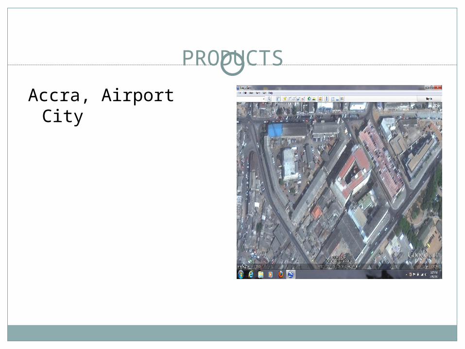
PRODUCTS
Accra, Airport City