Embed Size (px)
Citation preview

The University of MaineDigitalCommons@UMaine
Earth Science Faculty Scholarship Earth Sciences
7-1975
Glacial Geologic Investigation of Upper RennickGlacier Region, Northern Victoria LandPaul Andrew MayewskiUniversity of Maine, [email protected]
Follow this and additional works at: https://digitalcommons.library.umaine.edu/ers_facpub
Part of the Glaciology Commons, and the Hydrology Commons
This Article is brought to you for free and open access by DigitalCommons@UMaine. It has been accepted for inclusion in Earth Science FacultyScholarship by an authorized administrator of DigitalCommons@UMaine. For more information, please [email protected].
Repository CitationMayewski, Paul Andrew, "Glacial Geologic Investigation of Upper Rennick Glacier Region, Northern Victoria Land" (1975). EarthScience Faculty Scholarship. 210.https://digitalcommons.library.umaine.edu/ers_facpub/210

Denton, G. H., and R 1. Armstrong. 1968. Glacial geology and chronology of the McMurdo Sound region. Antarctic
Journal of the U.S., III(4): 99-101. Denton, G. H., R. 1. Armstrong, and M. Stuiver. 1970. Late
Cenozoic glaciation in Antarctica : the record in the McMurdo Sound region. Antarctic Journal of the U.S., V(I): 15-21.
Denton, G. H. , R 1. Armstrong, and' M. Stuiver. 1971. Late Cenozoic glacial history of Antarctica. In: Late Cenozoic GlacialAges (K. K. Turekian, editor). New Haven, Yale University Press. 267-306.
Hollin, J. T. 1962. On the glacial history of Antarctica. J ournal of Glaciology, 4: 173-195.
Katz, H. R , and B. C. Waterhouse. 1970. Geologic situation at O'Brien Peak, Queen Maud Range, Antarctica. N.Z. Journal
. of Geology and Geophysics, 13: 1038-1049. Mayewski, P. A. 1973. Glacial geology and late Cenozoic his
tory of the Transantarctic Mountains, Antarctica. Ph.D. dissertation. Columbus, The Ohio State University. 216p.
Mercer, J. H. 1968. Glacial geology of the Reedy Glacier area, Antarctica. Bulletin of the Geological Society of America, 79: 471-485.
Mercer, J. H. 1972. Some observations on the glacial geology of the Beardmore Glacier area. In: Antarctic Geology and Geophysics (RJ. Adie, editor). Oslo, Universitetsforlaget. 427-433.
Skinner, D. N. B., and J. Ricker. 1968. The geology of the region between the Mawson and Priestley glaciers, north Victoria Land, Antarctica: part II , Upper Paleozoic to Quaternary geology. N.Z. Journal of Geology and Geophysics, 11: 1041 -1075.
Glacial geologic investigation of upper Rennick Glacier region,
northern Victoria Land
P. A. MAYEWSKI*
Department of Geological Sciences Institute for Quaternary Studies
University of Maine Orono, Maine 04473
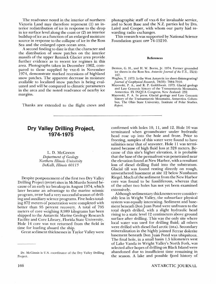
The 1974-1975 field season was spent investigating the upper Rennick Glacier area (figure) for (1) the relationship between the glacial history of the study area and the glacial histories already defined for more southerly sectors of the Transantarctic Mountains, (2) the history and dimensions of former fluctuations of the east antarctic ice sheet, Rennick Glacier, and its tributaries, as recorded in glacial deposits, and (3) the significance ofthis area in paleoclimatic reconstructions of Antarctica and the world.
*Present affiliation: Department of Earth Sciences, University of New H ampshire , Durham, New Hampshire 03824.
164
The Rennick Glacier region was chosen because ' (1) air photo inspection and flight reconnaissance indicated that the area provides the best inland ex- ' posure of glacial deposits in northern Victoria Land, (2) Rennick Glacier is the largest outlet glacier in northern Victoria Land and as such could record the glacial history of several interconnected ice masses, namely the east antarctic ice sheet, the Evans Neve, Gressitt Glacier, and Canham Glacier, and (3) unlike outlet glaciers farther south along the Transantarctic Mountains it drains into the open ocean and not into the Ross Sea. Drainage into the lopen ocean allows Rennick Glacier to ,respond directly to east antarctic ice thickness changes and to sea level changes. Rennick Glacier also provides a potentially wide avenue for the inland transport of moisture at times when the ocean is ice-free.
Fieldwork was done over 59 days (from Novem~ ber 10, 1974;·toJanuary7, 1975) by a four-person motor toboggan party operating from two main tent camps (figure). The party consisted of Sergei Aleksandrovich Abakumov, Arctic Geological Research Institute (Soviet Union), who conducted . bedrock investigations, John W. Attig, Jr., and Robert D. Slocum, University of Maine, who assisted in the glacial geology, and myself. Snowmobile traverses of 2 to 14 days were made from the main camps, with duration depending on surface conditions en route (figure). Although the Alpine 440 ER Ski Doo snowmobiles proved efficient field vehicles, their gas mileage varies with snow surface changes. This variation, combined with a limitation as to quantity of fuel carried, largely dictated routes and traverse times. Field flights were made, courtesy of the U.S. Navy's Antarctic Development Squadron Six (vxE-6), using Lc-130 Hercules airplanes, and were shared with N.Z. geological parties led by Malcolm Laird and Roger Cooper.
Detailed glacial histories were determined for several areas (figure) in the upper Rennick Glacier area. Preliminary interpretation of results reveals a history punctuated by four glacial episodes, with all but the oldest two being separated by identifiable periods of glacier recession. The glacial episodes, defined by moraines, drift sheets, and erratics, were differentiated in the field by (1) elevation, continuity, and distribution of glacial deposits, (2) lithologic and mineralogic components of the deposits, (3) weathering of surficial clasts capping the deposits, and (4) directional indicators recording different flow paths of the ice masses responsible for the deposition of the glacial materials.
Laboratory analyses are being made to differentiate between soils developed on the various glacial deposits. Once the glacial episodes are spatially refined, ice surface reconstructions will be made. The glacial events and ice surface reconstructions then
ANT ARCTIC JOURNAL

G r t S $ 1 tt
~-'-SC""A-LE,------'I.5 K rn .
6 , Hain tent ClIIDpS .
6: Secondary tent C8.ll>pS . Hotor toboggan routea (with au dace conditions) -
i
.I ./
Eva n s
Neve
____ Good aurface (sastrug! , in genera! , < 10 Cll! . high) . _ ._ . _. Hed!u>;ll surface {saatrugi, in general, < )0 Clll. high}. . .... .. ..... Poor surface (sastrugi , ingene ral,' )OC>;II . high) . .,~
'--"s 6"'. LC;;E~I 5 K m,
Motor toboggan routes and surface conditions.
.. _ .. _ .. Poor s urface (crevasses ).
... _ ... _ Poo r surface (crevasses SlId icefalls) . *: Designate general a r eas in which detailed studiea
were undertaken .
will be compared to those made farther south using methods and results as summarized by Mayewski and Goldthwait (1973) and Mayewski (in press).
Two findings to date relate to the youngest glacial episode (which by definition continues to the present). First, observations of lateral and terminal glacier margins point to recent readvance of these margins. Observation of the read vance is confined to interior northern Victoria Land and most likely represents an advance of less than several tens of meters. Evidence for the read vance includes steeply cliffed ice margins, locally advancing over previously developed ice-cored moraines. An apparent incongruity exists between the noted readvance of inland ice and the recent collapse of a formerly ex-
July/August 1975
panded ice sheet in the Ross Sea (Hughes, 1973; Denton and Borns, 1974).
Substantiating the suggestion of recent collapse, during reconnaissance flights along the northern Victoria Land coast, we saw, in places, intensely crevassed ice draped over highlands above the present glacier network. The topographic anomaly of these crevasses may be the result of response to a recent drop in ice level and consequent change in ice flow around coastal peaks. This event occurred recently enough to prevent disintegration of remnant crevassed ice on these high coastal peaks. The former higher ice level may have been maintained by the grounded ice sheet suggested by Denton and Borns (1974).
165
The readvance noted in the interior of n0rthern · Victoria Land may therefore represent (1 ) an interior redistribution of ice in response to the drop in ice surface level along the coast or (2) an interior buildup o( ice as a function of an enlarged moisture source in response to the collapse of ice in the Ross Sea and the enlarged open ocean area.
A second finding to date is that the character and the distribution of snow patches on the interior massifs of the upper Rennick Glacier area provide further evidence as to recent ice regimes in this area. Photographs taken in December 1962, compared to those supplied by VXE-6 in November 1974, demonstrate marked recessions of highland snow patches. The apparent decrease in moisture available to localized snow patches is being evaluated and will be compared to climatic parameters in th~ area and the noted readvance of nearby ice margms.
Thanks are extended to the flight crews and
Dry Valley Drilling Project, 1974-1975
L. D. MCGINNIS Department of Geology
Northern Illinois University DeKalb, Illinois 60115
Despite postponement of the first two Dry Valley Drilling Project (DVDP) sites in McMurdo Sound because of an early ice breakup in August 1974, which later became an advantage to the marine seismic program, DVDP had a very successful season of drilling and auxiliary science programs. Five holes totaling 872 meters of penetration were completed with better than 95 percent recovery. A total of 795 meters of core weighing 8,989 kilograms has been shipped to the Antarctic Marine Geology Research Facility and Core Library, Florida State University. Hole 14 core was not returned from the field in time for loading aboard the ship.
Great sediment thicknesses in Taylor Valley were
Dr. McGinnis is U.S. coordinator of the Dry Valley Drilling Project.
166
photographic staff of VXE-6 for invaluable service, and to Scott Base and the N .Z. parties led by Drs. Laird and Cooper, with whom our party had rewarding radio exchanges.
This research was supported by National Science Foundation grant OPP 74-15210.
References
Denton, G. H., and H . W. Borns, Jr. 1974. Former grounded ice sheets in the Ross Sea. Antarctic J ournal of the U.S., IX(4): 167.
Hughes, T. 1973. Is the West Antarctic ice sheet disintegrating? J ournal of Geophysical R esearch, 78(33): 7884-7910.
Mayewski, P. A., and R P. Goldthwait. 1973. Glacial geology and Late Cenozoic history of the Transantarctic Mountains, Antarctica. IX INQUA Congress, New Zealand: 232.
Mayewski, P. A. In press. Glacial geology and Late Cenozoic history of the Transantarctic Mountains, Antarctica. Columbus, The Ohio State University, Institute of Polar Studies. Report.
confirmed with holes 10, 11, and 12. Hole 10 was terminated when groundwater under hydraulic head rose up into the hole and froze. Prior to freezing, samples of this water were found to have salinities near that of seawater. Hole 11 was terminated because of high fluid loss at 328 meters. Because of this site's higher elevation, it is probable that the base of the permafrost was penetrated near the elevation found at New Harbor, with a resultant loss of diesel drilling fluid into the substratum. Glacial till was found resting directly on rough, unweathered basement at site 12 below Nussbaum Riegel. Much of the sediment from the New Harbor core was found to be fossiliferous, whereas that of the other two holes has not yet been examined extensively.
Although sedimentary thicknesses were considerably less in Wright Valley, the subsurface physical system was equally interesting. Sediment and basement beneath Don Juan Pond were unfrozen to the total depth drilled, with a slight hydraulic head rising to a static level 12 centimeters above ground surface after drilling. This was the only site where local water was used for drilling fluid; all others were drilled with diesel fuel arctic (DFA) . Secondary mineralization in the highly jointed Ferrar dolerite basement beneath Don Juan Pond was ubiquitous . . The final hole, in a small basin 1.5 kilometers west of Lake Vanda in Wright Valley'S North Fork, was selected after hopes of drilling on Black Island were abandoned due to insufficient time remaining in the season. A lake and possible fjord history of
ANTARCTIC JOURNAL


![Seasonal Dynamics of a Temperate Tibetan Glacier Revealed ... · Remote Sens. 2020, 12, 2389 2 of 16 predicting glacier-related disasters, such as glacial lake outburst floods [3,4],](https://img.pdfslide.net/doc/110x75/5f91e6fd7c03842f18777603/seasonal-dynamics-of-a-temperate-tibetan-glacier-revealed-remote-sens-2020.jpg)