Embed Size (px)
Citation preview

All three curves thin out between 1100 and1700 metres above sea level. This indicatesthat the height of the Inland ice and thejulianehäb ice cap must have been ratherconstant through most of the holocene period, It is in aceordanee with the theoreticalconsiderations of the plasticity of an ieeeap, as given by ]. Orowan and ]. Nye.
It must be noticed, thar the trim line thinsout ca. 1200 metres above sea level. Onefactor eould be that the Inland Ice and thejulianehäb ice eap, expressed as a functionof the altitude, than have an ablation less
than the loeal glaciers (after H. Ahlmann).
Another and more possible eause for the fastthinning out of the lowermost eurve eouldbe a new wave of iee indicating a futureadvance. Push moraines in high er altitudesof thc Qoroq and Kiagtut sermia glaeierseould be so interpreted. Considering thismechanism, we should have a melting andretreating system in the lowermost parts ofthe lobes From the iee eap, but an expanding system of ice in the areas near the firnlimit.
Glacial Geology of Northern Greenland *William E. Davies, Washington ,:-,:-)
Abstract. From 1950 through 1900 studies on theglacial geology of northern Greenland havebeen made in co operation with the U. S. AirForce Cambrf.dge Research Laboratories. As aresult of these studies foul' distinct phases ofthe latest glaciation have been recogrrizcd. Thelast glaciation extended over most of the landand removed traces of previous anes. Retreatof the ice mass began some time previous to0000 years ago. This was followed by a rtse insea level which deposited elay-silt sueeeeded bykarne gravels around stagnant ice lobes in thelarge valleys. Marine terraees, up to 129 metersabove present sea level, developed as readjustment occurred in the land free of ice. About3700 years ago an advance of glaciers downmajor fjords took place followed by retreat toapproximately the present position of the Ice.Till in Peary Land, north of Frederick E. HydeFjord, contains only Iocally derived matertalsindicating that the central Greenland ice capdid not cover the area.
Zusammenfassung: Glazialgeologie von Nordgrönland. Von 1955 bis 1900 wurden in Zusammenarbeit mit den U.S. Air Force Cambridge ResearcllLaboratories Studien über die Glaziaigeologie vonNordgrönland gemacht. Als ein Ergebnis dieserUntersuchungen wurden vier getrennte Phasender letzten Vereisung erkannt. Die letzte Vereisung dehnte sich über den größten Teil desLandes aus und beseitigte Spuren von vorhergegangenen. Der Rückzug des Eises begann vorgut 6000 Jahren. Dieses wurde aus dem Anstiegdes Meeresspiegels festgestellt, wobei Ton undSchluff gefolgt von Kame Schottern rund umdie stagnierenden Gletscherzungen in den großen Tälern abgelagert wurden. lVlarine Terassen - bis zu 129 m über dem jetzigen Meeresspiegel - zeigen, wie der Rückzug in dem eisfreien Land eintrat. Vor etwa 3700 .Jahren fandein Vorrücken der Gletscher durch die I-Iauptfjorde statt, gefolgt von einem Rückzug aufetwa den gegenwätttgen Eisstand. Grundmoränen in Peary-Land, nördlich des Frederick E.Hyde-Fjordes, enthalten nur örtliches Material,was beweist, daß das zentrale grönländische Inlandeis dieses Gebiet nicht bedeckte.
Sinee 1956 the D.S. Air Force CambridgeResearch Laboratories has condueted studiesof landforms and enginering properties ofsoils in northern Greenland. Members ofthe U. S. Geologieal Survey participated inthe geological aspcet of this research, andinvestigated the glacial geology of PearyLand, Kronprins Christian Land, and adjacent areas.
Northern Greenland consists of three majorphysiographie divisions:
1) an area of low alpine mountains inPcary Land, north of Frederick E. HydeFjord,
2) similar mountains along the northeastcoast south of Independence Fjord, and
3) a dissected plateau formed of non-Iolded late Preeambrian and early Paleozioc rocks inland from the mountainouseoastal areas.
The glacial geology of northern Greenlandhas been given scant attcntion. Lauge Kochoutlined the basie concepts of former glaciation, which wcre based on observationsmade while on the Danish Bicentenary ]ubilee Expedition in 1921 (Koch, 1927,1928a, b). Troelson (1949, 1952), while onehe Dansk Pearyland-Ekspcdition 1947-50,filled in details around Brerilund Fjord.
*) Publication authorized by Di rector', U. S. Geological Survey**) William E. Davies, U.S Geological Survey, Washington 25, D.C., USA
94

Eigil Knuth, on his traverse of DanmarkFjord in 1955 (Knuth, 1958), collected inforrnation concerning marine terraces. Fieldwork for the present paper was done duringrhe summers of 1956,1957,1958, and 1960.
Features o} GlaciationFoul' major types of deposits, rnoraines,clay-silt, kames, and marine terraces, reflectmore extensive glaciation in the past, TheseFeatures occur throughout all of northernGreenland but they are best developedalong, and south of, Independence Fjord.
e 1 a y - s i 1 t D e pos i t S - Deposits ofclay-silt occur along may of the fjords andriver valleys of northern Greenland, as weIlas on portions of the narrow coastal plainbordering the mouritains on the north sideof Peary Land (figure 1). These depositshave two origins, lacustrine and marine;and along the lower part of river valleys incoastal areas they grade from one type toanother in short distances,
The marine clay-silt occurs throughout mostof northern Greenland and is uniformly
gray, poorly-bedded, and generally containslarge quantities of pelecypod shells, Themaximum height of the deposits is 105 meters on Polaris Promontory in northwestGreenland, whereas elsewhere in northernGreenland the height varies greatly. AlongDanmark Fjord the maximum height risesfrom 24 meters at the head of the fjord to41 meters midway along the fjord in a distance of 90 km. This gradient, 0,45 meterper kilometer, is 10 times as great as thatof the tilt of the younger raised marine terraces that have been formed on the claysilt. Along the coastal areas of Peary Landthe gradient appears to be reversed. AtBronlund Fjord the maximum height of themarine clay-silt is 68.6 meters. Eastwardand northward along the coast of PearyLand it declines in altitud- until along thecoast west of Kaffeklubben 0 and onKaffeklubben 0 it is only 2 meters abovepresent sea level. In most of this area theclay-silt is covered by later terrace gravel.
The pelecypod fauna in the marine clay-siltbeds is uniform throughout North Green-
/'
",:,,;"
c E
40
KAP MOIlR:l$ Jf$UP~V'-'"",k
'00,
20
82
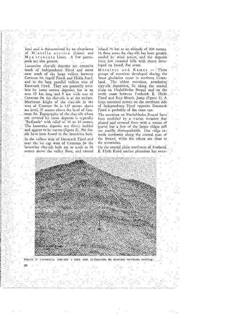
Figure 1: North Greenland, clay-silt deposits. Marine deposits shown by vertical !ines, lacustrinedeposits by horizontal lines, aeo!ian deposits by dots.
95
land and is characterized by an abundanceof H i a tell aar c t i c a (Linne) andM y a t run c a t a Linnc. A few gastropods are also present.Lacustrine clay-silt deposits are extensivesouth of Independence Fjord and occurover much of the large valleys betweenCentrum So, Ingolf Fjord, and Hekla Sund,and in the long parallel valleys west ofDanmark Fjord. They are generally overhin hy kame terrace deposits; but in anarea 15 km long and 5 km wide east ofCentrum So, the clay-silt is at the surface.Maximum height of the clay-silt in tbearea of Centrum So is 137. meters abovesea level, 37 meters above the level of Centrum 50. Topography of the clay-silt wherenot covered by kame deposits is typically"Badlands" with relief of 10 to 30 meters,The lacustrinedeposits are thinly beddedand appear to be varves (figure 2). No fossils have been found inthe lacustrine bcds.
In the valleys west of Danmark Fjordandnear the .icc cap west of Centrum So rheIacustrine clay-silt beds are as much as 36meters above the valley floor, and extend
inland 70 km to an altitude of 200 meters.In these areas the clay-silt has been greatlyeroded by wind action, and the depositsform low rounded hills 'wirh dunes developed on broad, flat areas.M 0 r a i n e san d Kam e s Threegroups of moraines developed during thelatest glaciation occur in northern Greenland. The oldest moraines, antedatingclay-silr deposition, liealong the coastalplain on Herlufsholm Strand and on thenorth coast between Frederick E. HydeFjord and Kap Morris Jesup (figure 3). Alarge morainal system on the northeast sideof Independence Fjord opposite DanmarkFjord is probably of the same age.The moraines on Herlufsholm Strand luvebeen modified by a marine invasion thatplaned and covered them with aveneer ofgravel but a few of the larger ridges stillare readily distinguishable: One ridge extends northwest along the central part ofthe Strand, while the others are close tothe mountains.On the coastal plain northwcst of FrcderickE. Hyde Fjord marine planation has remo-
Figure 2: Lacustrlne ctay-süt 1 mile east of Centrum 80 showlng varveIike beddrng.
96

- MAJOR: MORAl NE
Figure 3: North Greenland, major moratnes
ved most of the old moraine. In this areathe plain above 110 meters is formed ofbedrock with little or no moraine exeept atthe mouth ofFrederiek E. Hyde.. Fjordwhere later moraines oeeur. Below 110 meters the plain is formed of strands of beachgravel. Old moraines from a glaeier Formerly extending into Bliss Bugt, southeastof Kaffeklubben 0, form irregular gravelridges as weIl as 3 parallel groups of islandsalong the eoast 40 km northwesr of Frederiek E. Hyde Fjord.
On the coastal plain south of Kaffeklubben ° old moraines are larger .and morenumerous than elsewhere along the Areeiecoast of Peary Land. Three large morainesare parallel to the eoast and mountain front;a fourth moraine forms a seriesof low islands and shoals several kilometers offshore.Kaffeklubben '" is the most prominent partof these moraines. West of this area noprominent moraines exist and the rock platformalong the coast rises rapidly in altitude, At Kap Morris Jesup the platformis formed of frost-rived bedrock with very
few erratics, and old moraines are eonfinedto the side of the river valley,
The largestand most extensive system ofold moraines in Peary Land is on the northside of Independenee Fjord opposite Danmark Fjord. Thisarea, 600 square km, ismade up of a complex of morainal ridgesand intervening outwash plains. The rnajormoraines on the north side trend east-west;in the rest of thearea they trend northsouth. The highest moraine is the northernmost one; at its eastern end, 6 km north ofIndependenee Fjord, it reaehes an altitudeof 150 meters (figure 4). The top of thismoraine consists of a seriesof peaks separatcd by narrow saddles, Up to 106 metersaltitude the moraine eonsists of gray boulder day; above this it is mainly bouldercobble moraine with sand. North of the moraine is a broad area of outwash, The smaller moraines to the southform irregular;lowrounded ridges and are mainly cobblegrave1 with . clay and boulders. Marineshells oceur in these moraines within 4 kmof the eoast indieating the moraine was
97

Figure 4: Major moraine, 6 km north of Independence Fjord opposite Danmark Fjord. Lowerpart (light color) is cobbly ciay; upper part is gravel.
probably deposited in shallow coastal seas.Moraines younger than the clay-silt depositsare not eommon in North Greenland. In thearea between Centrum S0 and the ice eap6 morainal ridges are developed on theupland surface. These moraines end inmarginal ehanne1s and terraces in the valleys. Similar upland moraines oeeur on theplateau north of the lake.
Along Hekla Sund moraines lie above theclay-silt beds at the mouths of large rivervalleys. Along the northern part of thesound these moraines are only a few metersabove sea level while to the south they areas mueh as 118 meters above present sealevel. They are probably related to an '1dvance of a tongue of the Nioghalvfjerdsfjorden north along Hekla Sund.
Other moraines of similar age are in thetributary valleys of the rivers draining toHekla Sund and on the eastern side ofJ. C. Christensen Land.
Reeent moraines have been built up at thefront of many valley glaeiers. The mostprominent are along Ingolf Fjord and the
98
large valleys extending north and southfrom the fjord.
Kame areas coineide closely with the distribution of laeustrine clay-silt (figure 5). Inrhe large interconneeting valleys south ofIngolf Fjord, west of Danmark Fjord, eastof Midsommer S0er, and at the head ofDanmark Fjord kame terraces with largelakes cover most of the valley floors. Thesurfaees of the terraees are smooih withlittle discernible slope, They are formed ofrounded pebbles and cobbles a meter to over30 meters thick, generally lying on clay-silt,The lakes are in steep-sided kettles extending into the clay-silt.
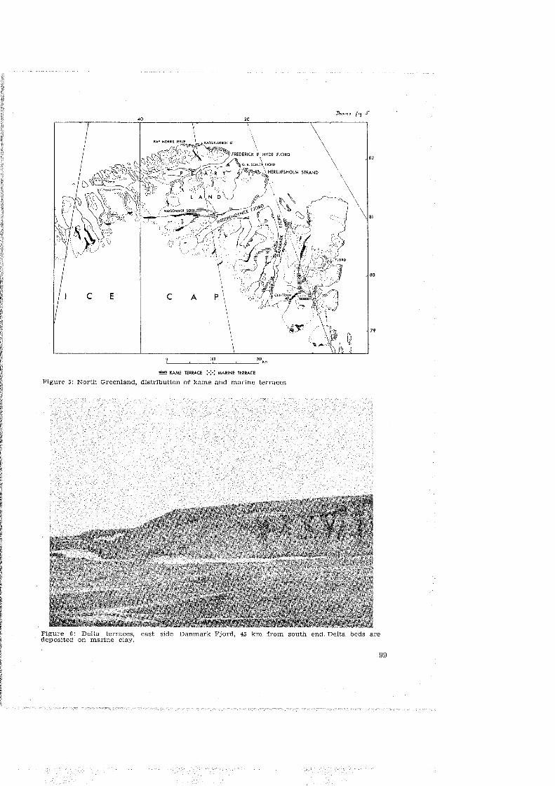
M a r i n e T e r r a e e s Throughoutnorthern Greenland raised marine terraeesarc eommon (figure 5). The best developedterraces are at the mouths of major strearnswhere delta terraces oeeur. Here, deltaiematerial is planed and reworked as the sealevel is lowered relative to former positionsof land (figure 6). The terraees are welldeveloped but are limited to the small areasof the delta. This type of development istypical on rivers entering Hekla Sund, Independenee Fjord, and Danmark Fjord.
c E
40
c A\
p \
\\
100,
20
82
80
79
- KAME TERRACE :.:.: MARINE TERRACE
Figure 5: North Greenland, distribution of kame and marine terraces
Figure 6: Delta terraces, east side Danmark Fjord, 45 km from south end. Delta beds aredeposited on marine clay.
99

Marine terraces also occur along the broadcoastal lowlands on the north coast ofPeary Land and along Independence Fjord.In contrast to the delta terraces, thesebeaches are developed by reworking of ma-
terials along a rising coast; and they extendfor greater distances, but are less developed,than the delta terraces.Most of the marine terraces contain depositsof gravel with a matrix of fine to coarse
IVe ".
o0e
0>o s
:;: ;;; ?:» z »x
0 (;~ :oe :oeC~ :;:. ~» »~
:oe :oe
::! Z Z.... m mC0 .... ....m m m
'" '"Q:oe :oe» »(;l (;l
n);-<VI
~
'"m0VI
m}>Ul-i
()
o}>Ul-i
.."
<5;;0
o
zom."mZomZ()m
zo~:I:
()
o}>Ul-i
."m}>;;0
-<,..}>Zo
I 1 L-__-'-- I I,
I ~I,,,,
-~-~'''--_.-, , : :", , , .: : i .
, ,"
, ,-----~rr-, , ' , , ,,
1 ' , , ,1 , ' , , , : ,
. I:/111 11 1 : I
1,'1"" 1,1I I:: I: : ,··· .,
1
,,,, ,
'Dr~"
,'I ," ,
I " .11:
1III I I ~~l_II I,
I',
I,"
I ,, , , ,,"
I, --rI
111"
Iill "'I' "",I1
,iTI_U1~______., ,
1,
111 11
iI.
III I' :"I
": .
I', I , : rD 1=I' I I ,
"I I , 1
I; I1." I
I,
1
:u I I.11 J.11 , 1, ,
JIII
,I I
" 1,
I 1" 1 1
11:::::::11:::: I
'l'Ii" ,: IIi" 1 ·I, ,,," 1 ·,,," ·
RIVIERADAL
SAEFAXI ELV
HEKLA SUND
INGOLF FJORD
SOUTH BRANCH
HEAD OFDANMARK FJOR{)
KAP VIBORG
KAP RENAISSANCE
NORD
HEAD OFBR(2lNLUND FJORD
MOUTH OFBRi2lNLUND FJORD
K0LEN
NEAR FALKEFJELDTROElSEN 1952
KAP PETER HENRIK
KAP RASMUSSEN
KAP WYCKOFF
10 KM ·SOUTH
OF SKAGAN
SKAGEN
DEPOT BUGT
KAP OLE CHIEWITZ
KAFfEKLUBBEN i2l
DOBBELTS0
KAP MORRIS JESUP
POLARIS PROMONiORYNORTHWEST GREENlAND
Figure 7: Major te rraces, North Greenland. 25-37, 45-57 terrace accentuated by heavy line.
100
sand. Subroundet to rounded pebbles andcobbles as much as 10 cm in size are common, The deposits are derived mainly fromreworked morainal material and, exceptalong the north coast of Peary Land, arecomposed of many different rocks.
Tertace development is not uniform at a11points and the number of terraee levels present varies from point to point. However,throughout northern Greenland one groupof terraces is persistent. South of Independenc- Fjord ir is from 25 to 37 rnetersabove present sea level and north of thefjord, 45 to 57 rneter (figure 7).
The higest distincr beach is 127 to 129 meters above sea level, and is along the middlepart of Independence Fjord and near themouth of Frederick E. Hyde Fjord. Belowthis level at least 16 terraces are recognizahle although a11 are not present at onelocality,
In addition to marine terraces, weli-developed storm ridges along raised strand linesoccur below an altitude of 17 meters. OnHerlufsholm Strand 11 we11-defined storrnridges ean bedistinguished; near G.B. SchleyFjord 14 to 19 are reeognizable; and at thehead and the mouth of Danmark Fjord, 18.
The overall tilt of the terraces is towardsthe south, However, a secondary tilt is superimposed, and 10ea11y the terraces alongDanmark and Independence Fjords are tilred toward the junction of these fjords. Thetilt in the southern part of Danmark Fjordis to the south at 0.05 meter/km; in the northern part it is to the northeast of 0.015meter/km.
Some radiocarbon dating of shells fromwirhin the main terraces have been made,and more are being made. From the dataon hand, the beaches above an altitude of24 to 50 meters are between 3700 and 6100years old, Those below this level are 500to 3700 years old. This subdivision is basedon dating of the prominent terraces in the24- to 50-metet zone 'c) as 3780±300 years,and the lowest strand above present hightide as 500 years. The maximum date of6100±300 )'ears is from the marine day.Whete day is present, marine terraces are
cut into the clay and are clearly youngerthan it,
Com position of Glacial Till
Independence Fjord and the southern partof Peary Land demarcate the boundary between two distinct types of glacial till. Southof a line 33 km north of IndependenceFjord (Troelsen, 1952) and extending eastward to a point opposite Danmark Fjord,the till contains a heterogeneous assemblageof metamorphic, igneous, and sedimentaryrocks of late Precambrian and early Paleozoic age (table 1). Included in this type arelarge quantities of unique pink granite withprominent angular quartz particles, and onlysma11 quantities of dark minerals. The granite is similar to that which craps out onthe north side of Parker Snow Bugt southof Thule, Northwest Greenland. This heterogeneous .till, characterized by the pinkgranite pebbles, is eommon From Thujenorth through Nyeboe Land and extendswest into eastern Ellesmere Island nearAlert (R. L. Christie, oral communicarion)and east throughout the area south of Independenee Fjord.
North of the line 33 km north of Independence Fjord, ti11 components vary Frompoint to point, but at a11 points the till isformed of locally derivcd material. Thecharacteristic pink granite pebble is lackingin the northern till.
Glacial History
In northern Greenland only one glaciationis recognizable. This glaciation, much ofwhich still exists, erased evidence of formerglaciation. During niaxi111U111 developmentof this glaciation the central ice cap ofGreenland transported rill charaeterized bypink granite pebbles. This glaciation extended 33 km north of Independenee Fjordwhere it was buffered by loeal ice eapsFrom rhe high mountain areas along thesouth side of Frederiek E. Hyde Fjord. Tilllaeking the distinctive pink granite pebblesand with only locally-derived materials iseharaeteristies of the glaeial depositsof themountain iee caps. Move111ent of the iceeap along the north side of the eentral iee
*) Radiocarbon dating by Meyer Rubin, U, S. Geological Survey
101

Tcble I COMPOSITION OF TILLNORTH GREENLANDLOCALITY (percent present)
IiI ~ ,;:
Q)
'ö '" '0:: oI '" .:: .:: .::i
0 Q) Q) C<l'ö ii.' P:: öP:: Ul
'"Ul
i 0 'ö '" ~~ 'eilI ii.' .:: .Ei .::I :::J Q) 000> Q)
'I-f "2 P< sP< P::"0bJl Q 0. ;,:~ 0.
'" C<l C<l.:: rQ ~ g~ ~H
I~I~Rock Type
Thule red I I140
I3 I
1sandstone & quartzite
130 130 5 15 15 15 50 I 5 40
Thule withe I '
1
20!
sandstone & quartzite I 20 I 50 5 15 40 40 20 15 40 40
Red Carboniferous i I Isandstone
I I I 25
Gray sandstoneI I
I
20 5 20
White coarse sandstone
I I5
IBrown sandstone I
I
5 P
Black sandstone I 20
Black slaty shale
I5 P
Limestone 5 15' I 30 30 15 90 25 5 ' 50 5
Basalt I 10
Amphibolite IIFelsite
I
5 5
Andesite-black 40
Red porphyriticandesite
I50
Pink granite P I 10 P 5 P 10 10 P P
iabase30 I 20 30 15 20 20 15 1 5 4 P 30
Red granite gneiss 2
Gray gneiss 20 I P 5 5 P 20 2 10 5 30
Chlorite schist I ,P 40 2 P 20 10 70 20I
White quartzite!
5 85I
P 20
rown-gray Iuartzite
I
75
uff, columnar Iuartzite 5 30I
Dark purpIeuartzite P 15 10 P
arble 10 P10
Gray phyllite5
late 5 10
reenstone 5 PI
uartz pebbles1
20 5I I, I
D
q
M
S
G
Q
Bq
Bq
102

cap was eastward and northeastward downthe troughs of Independence and DanmarkFjords and other major fjords; movementalong Frederick E. Hyde Fjord was eastward. North of Frederick E. Hyde Fjordand along Herlufsholm Strand glaciationwas of an alpine type with valley glaciersextending onto and across the flat coastalplain, South of Kaffeklubben 0 valley glaciers formed a piedmont ice sheet coveringthe coastal plain. 'I'his piedmont glacierwas probably similar in form to the shelfice on the north side of Ellesmere Island.
Abour 6000 years ago an abrupt change occurred, and a relatively rapid retreat of theiee took pIace. The ice caps shrunk to abouttheir present size and the major fjords andvalleys were occupied by stagnating remnants of the former ice sheet. Contemporaneously with the melting, large quantitiesof silt were deposited in the open portionsof fjords and along valley floors, Increasedmelting culminated in the resorting and depositing of kame terrace materials overlyingthe silt. Isolated remnants of buried iceblocks eventually melted and formed lakesalong the major valleys.
North of Frederick E. Hyde Fjord the valley glaciers and piedmont ice melted back,with most of the outwash material carriedoff to sea.
At the point of maximum rctreat the mainice cap and outlet glaciers were as much as60 km inland from their present position.
Afterdeposition of silt and kame materialsthe lag in isostatic readjustment resulted inan inundation of the land which was equivalent to a rise in sea level of as much as129 meters along the Arctic coast of PearyLand. With readjustment, as the landemerged, distinet marine terraces developedin coastal areas,
An advance of ice, primarily by glaciersafloat in major fjords, occurred about 3700years ago. This advance was about 30 to60 km down Fjord, and disrupted the tcrrace forming stage just prior to the Formation of terraces in the zone 24 to 50 metersabove present sea level. Since that time retreat occurred until 500 years ago, afterwhich only minor readjustments in the position of the glacier fronts have occured.
ReferencesK 0 c h , Lauge, 1927, Report on the Danish Bi
centenary Jubilee Expedition, north of Greenland 1920-23: Medd , om Grünland, bd. 70, nr. 1,p. 50-148.
-, 1928, The physiography of North Greenland;in Greenland: Comm. for the Direction Geol.and Geog1'. Investigations in Greenland, v. 1,p. 514-518.
-, 1928, Contributions to glaciology of NorthGreenland: Medd. om Grünland, bd. 65-II, p.302-322, 376-382.
K n u t h , Eigil, 1958, Det mystiske X i Danmark Fjord: Ejnar Munksgaards Forlag, Kübenhavn, 40 p.
TI' 0 e l s c n , J. C., 1949, Contributions to thegeology of the area round .rorgen BronlundsFjord, Peary Land, North Greenland: Medd.om Grünland, bd. 149, nr. 2, p. 19-22.
-, 1952, Notes on the Pleistocene geologyofpeary Land, North Greenland: Medd. fraDansk Geol. Forening, bd. 12, p. 211-220.
Die Polarlichtzone der Südhalbkugel *Von Otto Schneider, Buenos Aires ,:.,:.
Zusammenfassung: Nach einer kurzen Einleitung über die Schwierigkeit der Bestimmung derLage der Polarlichtzone auf der Südhalbkugelbehandelt der Verfasser methodische Fragenüber die Möglichkeit der Definition der Polarlichtzone sowie Über die zeitliche Veränderlichkeit, Inhomogenitäten der Beobachtungen undüber die F'orrn der Zone. Bei den Lösungsversuchen werden zunächst die älteren Vorschläge,sodann die Isochasmen nach Hultqvist, fernerandere theoretisch abgeleitete Südlichtzonen sow ie die neuesten Versuche von Bond und Jackadargelegt, die Zone mit Hilfe von wirklichenSüdlicht-Beobachtungen festzu legen. Danach folgen einige zusätzliche Ergebnisse~ die sich aufGrund der japanischen, britischen und argenti-
nlschcn Beobachtungen ergaben. Mit der abschließenden Bemerkung, daß die Sücllichtzonenur Über die I-Iälfte ihres Umfanges einigerm aßen sicher festgelegt ist, beendet der Verfasser seine Darlegungen, denen er e lrie TabelleÜber d ie I<:oorclinaten der crwähnten Stationenund ein ausführliches Literatur-Verzeichnis anf'üg t.
Abstractr The Polar Light Zone of the SouthernHemisphere. After a short introduction dealingwtth the difficulties of the determination of theposition of the polar light zone on the SouthernHemisphere the author treats methodical quest.ions of the possibility of the definition of thepolar light zone as weH as of the temporal
0) Contribuci6n deI Instituto Antiirtico Argentino NI'. 55.
**) Dr. otto Schneider, Instituto Antiirtico Argentino, Buenos Aires, Cerrito 1248.
103