Embed Size (px)
Citation preview
Send Orders for Reprints to [email protected]
The Open Geology Journal, 2015, 9, 1-10 1
1874-2629/15 2015 Bentham Open
Open Access Glacial Karst Aspects About the DeKalb Mounds in Illinois, USA Michael Iannicelli*
7109 21 Avenue, Brooklyn, New York 11204, USA
Abstract: The glacial dead-ice origin of the DeKalb mounds in DeKalb County, Illinois, USA, is advanced in this study by discussing it within the context of late Wisconsinan glacial karst. Glacial karst is glacial dead-ice topography that resembles carbonate bedrock karst topography. The only difference here is that thermo-erosion or melting of ice by groundwater causes glacial karst, while dissolution of carbonates by groundwater causes bedrock karst. For example, bedrock karst such as haystack hills, dolines and entranceless caves analogously match up to stagnant glacial ice blocks with supraglacial ice pits and entranceless glacial caves. Entranceless bedrock caves are caves with no opening (entranceway) that is big enough for a human, yet contain water and/or accumulations of silt and clay. Although stagnant glacial ice blocks and supraglacial ice pits have been discussed in the literature, entranceless glacial caves is an undeveloped concept which is expounded in this study. An entranceless glacial cave is actually a subglacial/englacial, water-filled cavity formed by thermo-erosion due to active-layer groundwater/talik piping laterally seeping out of the adjoining terrain and into a body of glacial ice, as seen in modern glaciers of Antarctica. This type of water-filled cavity can also be classified as a subglacial or englacial lake. The study also discusses relationships to embryonic DeKalb mounds such as: why a localized part of the continental ice sheet degenerated into stagnant ice blocks; and the Wisconsinan creation of one or more steep depressions in the till plain underlying a DeKalb mound.
Keywords: DeKalb mounds, entranceless glacial caves, glacial dead ice, glacial karst, ice pits, stagnant glacial ice blocks.
1. INTRODUCTION
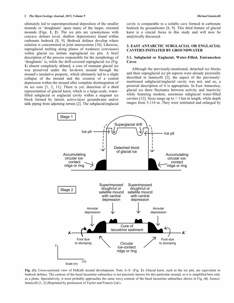
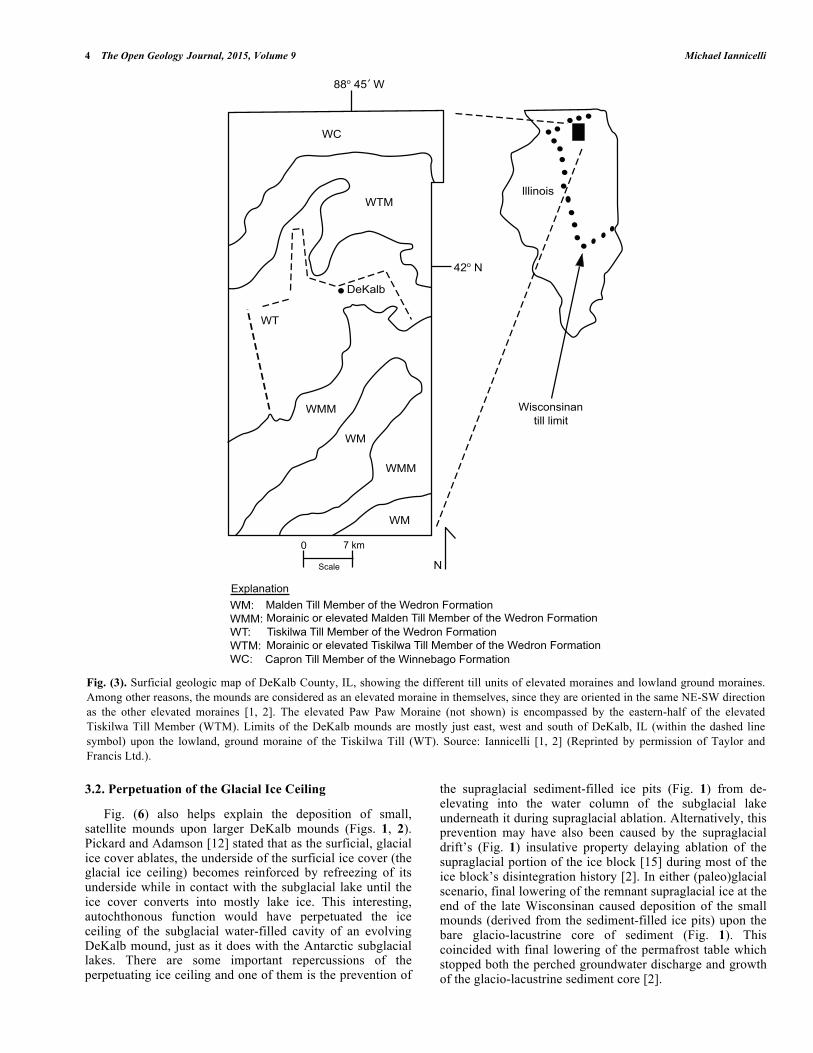
The glacial dead-ice origin of the DeKalb mounds in DeKalb County, Illinois, USA [1, 2] now permits us to link them to a spectrum of Quaternary glacial karst processes. The DeKalb mounds are relict, late Wisconsinan (ca. 25k-13.5k YBP), NW-SE oriented hillocks that had been formerly interpreted as either pingos [3] or glacial ice-walled lake plains [4, 5], but were proven to be a glacial dead-ice moraine produced by glacial dead-ice processes [1, 2]. Sizes range from 400 m to over 1 km in length, while their heights range up to 5 m. The particular landform term ‘crater-kettles’ [6] is designated for all the oriented mounds composed of gigantic, circular ice-contact ridges or rims containing a core of glacio-lacustrine sediment overlying a NE-SW trending intermorainal lowland, while the adjacent elevated moraines trend in the same direction [1, 2] (Figs. 1-3). An additional feature is the superimpositional attachment of smaller non-oriented, (satellite) mounds or ‘doughnuts’ upon many of the gigantic, oriented mounds [1-3]. The sedimentological composition of a gigantic, oriented mound is shown in Fig. (4). Kettles such as the DeKalb mounds both sedimentologi-cally and morphologically match up accurately with other kettles in Saskatchewan, Canada [1, 2, 7] and New York, USA [2]. Glacial karst is an established concept [8, 9], while the definition of glacial karst is glacial dead-ice topography that resembles carbonate bedrock karst topography. Glacial dead ice is stationary glacial ice without the capability of ever
*Address correspondence to this author at 7109 21 Avenue, Brooklyn, New York 11204, USA; Tel: 718-259-5574; Fax: 1-718-259-5574; E-mail: [email protected]
remobilizing, while melting in place. Even though certain facets of glacial karst are developed in the literature, other important aspects are not. Hence, the aim of this study is to both impart and expand recognition of specific glacial karst processes and forms that were never reported before. Accomplishment of this is by using a simple, familiar method which is “the present is the key to the past”. This is facilitated in this study by using modern-day examples as analogues that reflect the evolution of the relict DeKalb mound landforms.
2. GLACIAL KARST RELATIVE TO THE DEKALB MOUNDS
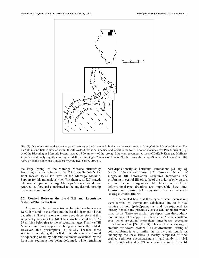
This study characterizes individual elements of a continuum of glacial karst forms revolving around the glacial dead-ice framework of the DeKalb mounds. Even though glacial karst and carbonate bedrock karst are closely entwined subjects, it should be noted that groundwater is a thermo-erosive and dissolution agent that ultimately forms glacial karst and bedrock karst, respectively. The bare beginnings of the DeKalb mounds’ development started out as an assemblage of detached (paleo)glacial ice blocks [2] (Fig. 5), while these are equivalent to haystack hills or hums composed of carbonate bedrock [8, 9]. Haystacks are isolated, erosional remnant hills that remain from an old age karst cycle. Clayton [8] also noted that detached ice blocks later formed kettles. A possible origin for the breakup of a localized area within the ice sheet, which led to the pre-existence of the individual, stagnant ice blocks will be discussed later in this study. A second glacial karst aspect is supraglacial, sediment-filled ice pits occurring upon many of the (paleo)ice blocks which
2 The Open Geology Journal, 2015, Volume 9 Michael Iannicelli
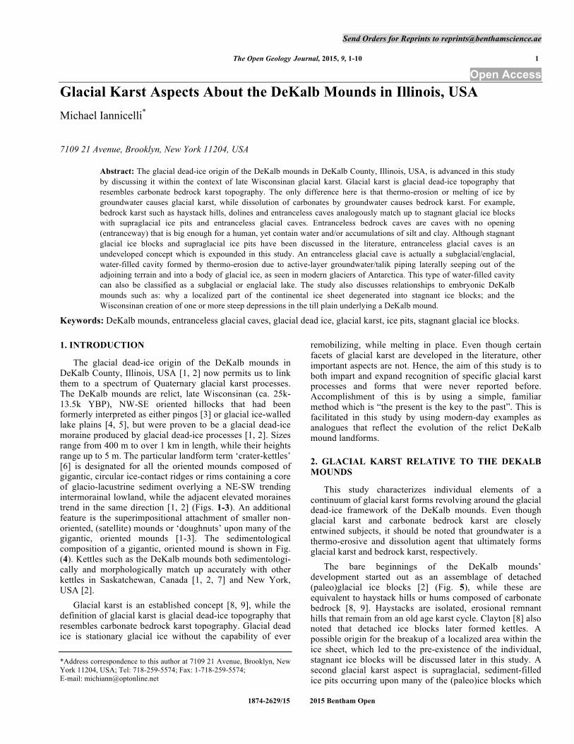
ultimately led to superimpositional deposition of the smaller mounds or ‘doughnuts’ upon many of the larger, oriented mounds (Figs. 1, 2). The ice pits are synonymous with concave dolines (oval, shallow depressions) found within carbonate bedrock [8, 9]. Bedrock dolines develop where solution is concentrated at joint intersections [10]. Likewise, supraglacial melting along planes of weakness (crevasses) within glacial ice initiate supraglacial ice pits. A brief description of the process responsible for the morphology of ‘doughnuts’ is, while the drift-covered supraglacial ice (Fig. 1) almost completely ablated, a core of remnant glacial ice was preserved under the let-down mound through the mound’s insulative property, which ultimately led to a slight collapse of the mound and the creation of a central depression within the mound after complete disintegration of its ice core [1, 2, 11]. There is yet, detection of a third representation of glacial karst, which is a large-scale, water-filled subglacial or englacial cavity within a stagnant ice block formed by lateral, active-layer groundwater and/or talik piping from adjoining terrain [2]. The subglacial/englacial
cavity is comparable to a soluble cave formed in carbonate bedrock by groundwater [8, 9]. This third feature of glacial karst is a crucial focus in this study and will now be analytically discussed.
3. EAST ANTARCTIC SUBGLACIAL OR ENGLACIAL CAVITIES INITIATED BY GROUNDWATER
3.1. Subglacial or Englacial, Water-Filled, Entranceless Caves
Although the previously-mentioned, detached ice blocks and their supraglacial ice pit aspects were already pictorially described in Iannicelli [2], the aspect of the previously-mentioned subglacial/englacial cavity was not, and so, a pictorial description of it is appropriate. In East Antarctica, glacial ice there fluctuates between activity and inactivity while featuring modern, enormous subglacial water-filled cavities [12]. Sizes range up to > 1 km in length, while depth ranges from 3-114 m. They were inititiated and enlarged by
Fig. (1). Cross-sectional view of DeKalb mound development. Note A-A’ (Fig. 2). Glacial karst, such as the ice pits, are equivalent to bedrock dolines. The contour of the basal lacustrine subsurface is not precisely known for this particular mound, so it is simplified here only as a plane. Speculatively, it most probably approaches the same wavy contour of the basal lacustrine subsurface shown in Fig. (4). Source: Iannicelli [1, 2] (Reprinted by permission of Taylor and Francis Ltd.).
!"#$%&'
()%&*+"
,))-.-/#"+0$)+1)-/#1&+)%2
)30"#)"1+4$%&31&1+0$
!-*%1$/#)+#/&41+5"
()%&*+"
6%"#)7%4&8/3)935&$/#)+#/&+)%
,))-.-/#"+0$)+1)-/#1&+)%2
)30"#)"1+4$%&31&1+0$
!"#$%&:!-*%1+.*3;%443-$70-"&31
;#"%//+"%&.3-04<+"7&)%0"1#/4%*1%;;+30
!-*%1+.*3;%443-$70-"&31
;#"%//+"%&.3-04<+"7&)%0"1#/4%*1%;;+30
4%*1%;;+30,00-/#1
4%*1%;;+30,00-/#1
=33"&4-%"3&;/-.*+0$
=33"&4-%"3&;/-.*+0$
>31%&35/#)-;"1+0%&;%4+.%0"
+)%2)30"#)"1+4$%&31&1+0$
>+1)-/#1
!)#/%&?.@'AB
:
! !!
Glacial Karst Aspects About the DeKalb Mounds in Illinois, USA The Open Geology Journal, 2015, Volume 9 3
thermo-erosion from active-layer groundwater and/or talik piping laterally seeping into the glacial ice from the adjoining till and scree slope of a nunatak [12] (Fig. 6). The same mechanism is applicable to a DeKalb mound’s development because the (paleo)glacial ice block was surrounded by a till slope belonging to a circular ice-contact ridge (Figs. 1, 2), while lateral, active-layer groundwater melted some glacial ice to create a subglacial water-filled cavity or ‘repository’ [2]. The repository is interchangeably termed here as an entranceless water-filled glacial cave. Entranceless, water-filled and silt/clay-filled bedrock caves reported by Davis [13] and White [14] would be akin to the entranceless, water-filled glacial caves. There was also a delivery of suspended, groundwater-derived fine grains
(silt/clay) into the subglacial lake (repository) during sufficiently warm summers which settled out within it during winter, while sporadic, thin beds of sand were laid down during sufficiently warm summers, resulting in varve-like deposition (non-annual rhythmites) that comprised the DeKalb mound’s lacustrine facies [2, 3] (Figs. 1, 4). The volume of fine grains and sporadic sand beds within the glacio-lacustrine sediment core was subtracted from the circumference of the circular, ice-contact ridge, since this ridge was built up from two sources: slurries of supraglacial drift sliding over the ice block's edges (Figs. 1, 5) during wet climatic times; plus episodic loess deposition upon the ridge due to episodic glacial dust storms during dry climatic times.
Fig. (2). Plan view of the DeKalb mounds located immediately east of DeKalb, IL. Note A-A’ (Fig. 1). Also, note their NE-SW orientation, which is the same trend of the moraines shown in Fig. (3). Scale only applies to the mounds and not to the topographical highs and low of the till units. Diagram based on U.S.D.A. aerial photograph #3EE-127. Source: Iannicelli [1, 2] (Reprinted by permission of Taylor and Francis Ltd.).
!"#"$%&#'()*'($'"+*!(,-(./&*!(..*01231%
4)&.1
567*-2
8!"#"$%&#'()*."/*"+*!(,-(./&*!(..*012
31%
!"#"$%&#'()*'($'"+*0&.91:*!(..*01231%
;<#.&:&=(":
>(&:=*)(%)?.&%*()1@)":=&)=*%(9$1*"%*%(:$
A%1&)'19*)@,',&=1..(=1*2"?:9
4&=1..(=1*2"?:9*/(=')1:=%&.*91#%1,,(":"%*BB9"?$':?=CC
!
!!
4 The Open Geology Journal, 2015, Volume 9 Michael Iannicelli
3.2. Perpetuation of the Glacial Ice Ceiling
Fig. (6) also helps explain the deposition of small, satellite mounds upon larger DeKalb mounds (Figs. 1, 2). Pickard and Adamson [12] stated that as the surficial, glacial ice cover ablates, the underside of the surficial ice cover (the glacial ice ceiling) becomes reinforced by refreezing of its underside while in contact with the subglacial lake until the ice cover converts into mostly lake ice. This interesting, autochthonous function would have perpetuated the ice ceiling of the subglacial water-filled cavity of an evolving DeKalb mound, just as it does with the Antarctic subglacial lakes. There are some important repercussions of the perpetuating ice ceiling and one of them is the prevention of
the supraglacial sediment-filled ice pits (Fig. 1) from de-elevating into the water column of the subglacial lake underneath it during supraglacial ablation. Alternatively, this prevention may have also been caused by the supraglacial drift’s (Fig. 1) insulative property delaying ablation of the supraglacial portion of the ice block [15] during most of the ice block’s disintegration history [2]. In either (paleo)glacial scenario, final lowering of the remnant supraglacial ice at the end of the late Wisconsinan caused deposition of the small mounds (derived from the sediment-filled ice pits) upon the bare glacio-lacustrine core of sediment (Fig. 1). This coincided with final lowering of the permafrost table which stopped both the perched groundwater discharge and growth of the glacio-lacustrine sediment core [2].
Fig. (3). Surficial geologic map of DeKalb County, IL, showing the different till units of elevated moraines and lowland ground moraines. Among other reasons, the mounds are considered as an elevated moraine in themselves, since they are oriented in the same NE-SW direction as the other elevated moraines [1, 2]. The elevated Paw Paw Moraine (not shown) is encompassed by the eastern-half of the elevated Tiskilwa Till Member (WTM). Limits of the DeKalb mounds are mostly just east, west and south of DeKalb, IL (within the dashed line symbol) upon the lowland, ground moraine of the Tiskilwa Till (WT). Source: Iannicelli [1, 2] (Reprinted by permission of Taylor and Francis Ltd.).
!!"#$%##&!
&'
&()
&(
*+,-./
$0"#1
...23"24
&245"3423-362..#.2726
&))
&)
&))
&)
8 9#:7
;5-.+ 1
<=>.-3-62"3&)? )-.@+3#(2..#)+7/+A#"B#6C+#&+@A"3#D"A7-62"3
)"A-2325#"A#+.+E-6+@#)-.@+3#(2..#)+7/+A#"B#6C+#&+@A"3#D"A7-62"3(24:2.F-#(2..#)+7/+A#"B#6C+#&+@A"3#D"A7-62"3)"A-2325#"A#+.+E-6+@#(24:2.F-#(2..#)+7/+A#"B#6C+#&+@A"3#D"A7-62"3'->A"3#(2..#)+7/+A#"B#6C+#&233+/-G"#D"A7-62"3
&))?&(?&()?&'?
Glacial Karst Aspects About the DeKalb Mounds in Illinois, USA The Open Geology Journal, 2015, Volume 9 5
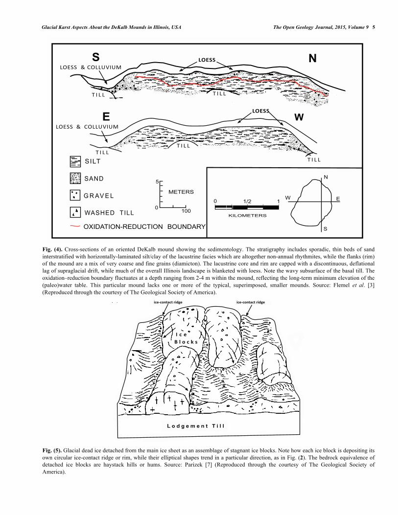
Fig. (4). Cross-sections of an oriented DeKalb mound showing the sedimentology. The stratigraphy includes sporadic, thin beds of sand interstratified with horizontally-laminated silt/clay of the lacustrine facies which are altogether non-annual rhythmites, while the flanks (rim) of the mound are a mix of very coarse and fine grains (diamicton). The lacustrine core and rim are capped with a discontinuous, deflational lag of supraglacial drift, while much of the overall Illinois landscape is blanketed with loess. Note the wavy subsurface of the basal till. The oxidation–reduction boundary fluctuates at a depth ranging from 2-4 m within the mound, reflecting the long-term minimum elevation of the (paleo)water table. This particular mound lacks one or more of the typical, superimposed, smaller mounds. Source: Flemel et al. [3] (Reproduced through the courtesy of The Geological Society of America).
Fig. (5). Glacial dead ice detached from the main ice sheet as an assemblage of stagnant ice blocks. Note how each ice block is depositing its own circular ice-contact ridge or rim, while their elliptical shapes trend in a particular direction, as in Fig. (2). The bedrock equivalence of detached ice blocks are haystack hills or hums. Source: Parizek [7] (Reproduced through the courtesy of The Geological Society of America).
!
"
#
$
!"#$$%%&%'"!!()*(+
!"#$$%%&%%'"!!()*(+
, * ! !
, * ! !, * ! !
!"#$$
, * ! !
!"#$$
, * ! !
!"#$
!%&'
( ) %* + #
,%!-+'..$"##
/0"'%$"/&1)+'23$"/&..4/2&'%)5
6777
8
9+$+)!
:"#/9+$+)!
7 6;<,
6
&
+
!
- - - - -
!"#$"%&'("')*!+,# !"#$"%&'("')*!+,#
- " #. / % " 0 1
! " # $ % & % ' ( ) * + , ,

6 The Open Geology Journal, 2015, Volume 9 Michael Iannicelli
Another effect of the perpetuating ice cover of an evolving DeKalb mound also accounts for why only late Wisconsinan, nanoparticle-sized, groundwater-derived, pollen was discovered in a glacial kettle, such as within a DeKalb mound [2] and even in other glacial kettles such as Chatsworth Bog in Livingston County, IL [2, 16]. This is because the perpetuating ice cover would have prevented wind-blown (eolian) macro-sized objects, such as small leaves and twigs, from being deposited within its subglacial lakes. The perpetuating ice cover also prevented wind-driven currents, since it allowed for the fall-out and settlement of the fine silt-sized and clay-sized grains within the subglacial lake, originally deposited by the active-layer, groundwater discharge [2]. These accumulating grains within the subglacial lake resulted in the varve-like, non-annual rhythmites of the glacio-lacustrine sediment core that were already previously discussed in this study.
4. RELATED GLACIAL CAVITIES AND UNRELATED ICE CAVES
Pickard and Adamson [12] noted the drainage of some water from out of one specific subglacial cavity that subsequently caused a collapse of its ice roof. This would be equivalent to large-scale sinkhole subsidence within carbonate bedrock, since the base of a doline collapses into a subterranean cave underneath it. A more familiar bedrock example of this is when either a well is overpumped or even drought that dramatically lowers the water table leading to subsequent cave-roof collapse and the creation of a sinkhole. It should be remembered that this is the difference between a doline and sinkhole, since both terms seem to be sometimes carelessly interchangeable in the literature. Modern glaciers with a subglacial cavity or chamber-like glacial cave containing a pond, such as the Nigardsbreen Glacier of Norway [17], may be potentially vulnerable to future ice-roof collapse, since its ice cavity is not completely
water-filled. This subglacial cavity is only different from the previously-mentioned Antarctic and DeKalb mound examples, since there is a ground-level entranceway. It is not known to this writer how its entranceway was formed. A minor contrast does exist here since the Nigardsbreen Glacier is situated in an alpine setting while the DeKalb mounds are situated in a lowland, prairie setting. It should also be noted that glacial caves are a different species from ice caves. One type of ice cave is formed by meltwater streams cutting through a frozen mass of mountainside snow avalanches which created entranceways within it such as ‘The Big Four Ice Caves’ in Washington State [18]. Another type of ice cave is a natural bedrock cave which houses a massive amount of perennial ice formed by the combination of trapped cold air and percolative surface water dripping through karstic bedrock and into the bedrock cave below it, while freezing into a very thick and extensive ice mass [19].
5. OTHER NOTABLE RELATIONSHIPS
5.1. Detachment of the (Paleo)Ice Blocks
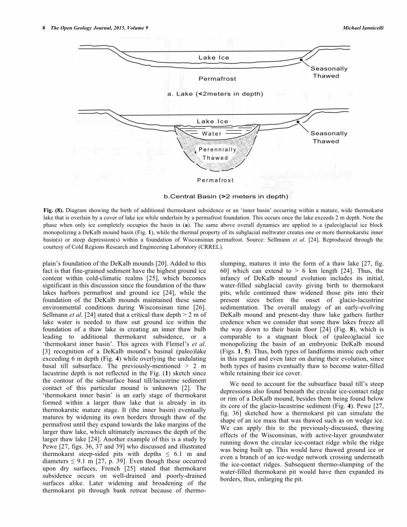
It would be intriguing to figure out why a localized part of the Wisconsinan continental ice sheet initially broke up into separate ice blocks in DeKalb County, IL. The cause of this may be correlated to a collision or intersection between the advancing ice front of the Princeton Sublobe and a very long, 5 km-wide, south-trending, elevated, linear moraine of the Marengo Moraine [20] (Fig. 7). The Marengo Moraine is located in Kane County, IL, and it was hardened into a rock-like mass due to (paleo)permafrost during the Wisconsinan. The DeKalb mounds were concluded by Iannicelli [1, 2] to be an elevated moraine in themselves, located 15-20 km west of the Marengo Moraine, while the DeKalb mounds and the sublobe’s end moraines are considered part of the Bloomington Morainic System. Hence, a possible reason for the assemblage of the (paleo)ice blocks may be ascribed to
Fig. (6). Longitudinal profile showing the formation mechanisms of an East Antarctic, modern subglacial lake which is actually a water-filled, entranceless glacial cave. It is initiated and enlarged by the thermo-erosion of active-layer groundwater discharging from within an adjoining till/scree slope of a nunatak (diagonal line pattern). Note the autocthonous function of the water-filled subglacial cavity as it reinforces its own ice ceiling by refreezing of an upper layer of the subglacial lake which adheres to the ice ceiling. This perpetuates its own ice cover, while the surficial glacial ice ablates. See text for roles of the perpetuating ice cover during the DeKalb mounds’ evolution. Source: Pickard and Adamson [12] (Reproduced through the courtesy of Cambridge University Press).
Glacial Karst Aspects About the DeKalb Mounds in Illinois, USA The Open Geology Journal, 2015, Volume 9 7
the large ‘prong’ of the Marengo Moraine structurally fracturing a weak point near the Princeton Sublobe’s ice front located 15-20 km west of the Marengo Moraine. Support for this rationale is when Wickham et al. [20] stated: “the southern part of the large Marengo Moraine would have retarded ice flow and contributed to the angular relationship between the moraines".
5.2. Contact Between the Basal Till and Lacustrine Sediment/Diamicton Rim
A questionable feature exists at the interface between a DeKalb mound’s subsurface and the basal lodgement till that underlies it. There are one or more steep depressions at this subjacent junction in Fig. (4). The subsurface basal till is 15-30 m thick belonging to the Wisconsinan-aged Tiskilwa Till Member and may appear to be glacitectonically folded. However, this presumption is unlikely because these structures underlying the DeKalb mounds were not formed by squeezing of till by adjacent ice blocks evidenced by the lacustrine sediment not being deformed, while remaining
post-depositionally as horizontal laminations [21, fig. 8]. Besides, Johnson and Hansel [22] illustrated the size of subglacial till deformation structures (antiforms and synforms) in central Illinois to be of the order of only up to a a few meters. Large-scale till landforms such as deformational-type drumlins are improbable here since Johnson and Hansel [23] suggested they are generally lacking in central Illinois. It is calculated here that these type of steep depressions were formed by thermokarst subsidence due to in situ, thawing of both (paleo)permafrost and (paleo)ground ice directly beneath the previously-discussed, subglacial water-filled basins. There are similar type depressions that underlie modern thaw lakes capped with lake ice at Alaska’s northern coast which are called ‘thermokarst inner basins’ according to Sellmann et al. [24] (Fig. 8). This applicable analogy is credible for several reasons. The environmental setting of both landforms is very similar: the marine plain foundation underlying the thaw lakes is mostly composed of fine-grained sediment encompassing silt and sandy silt [24], while 39.4% silt and 33.9% sand comprise most of the till
Fig. (7). Diagram showing the advance (small arrows) of the Princeton Sublobe into the south-trending ‘prong’ of the Marengo Moraine. The DeKalb mound field is situated within the till lowland that is both behind and lateral to the No. 3 elevated moraine (Paw Paw Moraine) (Fig. 3) of the Bloomington Morainic System, located 15-20 km west of the ‘prong’. Map view encompasses most of DeKalb, Kane and McHenry Counties while only slightly covering Kendall, Lee and Ogle Counties of Illinois. North is towards the top (Source: Wickham et al. [20]. Used by permission of the Illinois State Geological Survey (ISGS)).
! "! #! $%
"
#
&
'()
*
8 The Open Geology Journal, 2015, Volume 9 Michael Iannicelli
plain’s foundation of the DeKalb mounds [20]. Added to this fact is that fine-grained sediment have the highest ground ice content within cold-climatic realms [25], which becomes significant in this discussion since the foundation of the thaw lakes harbors permafrost and ground ice [24], while the foundation of the DeKalb mounds maintained these same environmental conditions during Wisconsinan time [26]. Sellmann et al. [24] stated that a critical thaw depth > 2 m of lake water is needed to thaw out ground ice within the foundation of a thaw lake in creating an inner thaw bulb leading to additional thermokarst subsidence, or a ‘thermokarst inner basin’. This agrees with Flemel’s et al. [3] recognition of a DeKalb mound’s basinal (paleo)lake exceeding 6 m depth (Fig. 4) while overlying the undulating basal till subsurface. The previously-mentioned > 2 m lacustrine depth is not reflected in the Fig. (1) sketch since the contour of the subsurface basal till/lacustrine sediment contact of this particular mound is unknown [2]. The ‘thermokarst inner basin’ is an early stage of thermokarst formed within a larger thaw lake that is already in its thermokarstic mature stage. It (the inner basin) eventually matures by widening its own borders through thaw of the permafrost until they expand towards the lake margins of the larger thaw lake, which ultimately increases the depth of the larger thaw lake [24]. Another example of this is a study by Pewe [27, figs. 36, 37 and 39] who discussed and illustrated thermokarst steep-sided pits with depths ≤ 6.1 m and diameters ≤ 9.1 m [27, p. 39]. Even though these occurred upon dry surfaces, French [25] stated that thermokarst subsidence occurs on well-drained and poorly-drained surfaces alike. Later widening and broadening of the thermokarst pit through bank retreat because of thermo-
slumping, matures it into the form of a thaw lake [27, fig. 60] which can extend to > 6 km length [24]. Thus, the infancy of DeKalb mound evolution includes its initial, water-filled subglacial cavity giving birth to thermokarst pits, while continued thaw widened those pits into their present sizes before the onset of glacio-lacustrine sedimentation. The overall analogy of an early-evolving DeKalb mound and present-day thaw lake gathers further credence when we consider that some thaw lakes freeze all the way down to their basin floor [24] (Fig. 8), which is comparable to a stagnant block of (paleo)glacial ice monopolizing the basin of an embryonic DeKalb mound (Figs. 1, 5). Thus, both types of landforms mimic each other in this regard and even later on during their evolution, since both types of basins eventually thaw to become water-filled while retaining their ice cover. We need to account for the subsurface basal till’s steep depressions also found beneath the circular ice-contact ridge or rim of a DeKalb mound, besides them being found below its core of the glacio-lacustrine sediment (Fig. 4). Pewe [27, fig. 36] sketched how a thermokarst pit can simulate the shape of an ice mass that was thawed such as on wedge ice. We can apply this to the previously-discussed, thawing effects of the Wisconsinan, with active-layer groundwater running down the circular ice-contact ridge while the ridge was being built up. This would have thawed ground ice or even a branch of an ice-wedge network crossing underneath the ice-contact ridges. Subsequent thermo-slumping of the water-filled thermokarst pit would have then expanded its borders, thus, enlarging the pit.
Fig. (8). Diagram showing the birth of additional thermokarst subsidence or an ‘inner basin’ occurring within a mature, wide thermokarst lake that is overlain by a cover of lake ice while underlain by a permafrost foundation. This occurs once the lake exceeds 2 m depth. Note the phase when only ice completely occupies the basin in (a). The same above overall dynamics are applied to a (paleo)glacial ice block monopolizing a DeKalb mound basin (Fig. 1), while the thermal property of its subglacial meltwater creates one or more thermokarstic inner basin(s) or steep depression(s) within a foundation of Wisconsinan permafrost. Source: Sellmann et al. [24]. Reproduced through the courtesy of Cold Regions Research and Engineering Laboratory (CRREL).
!"#$%&#'()
%*+,%-"+.!/$")"#(+01+2"3)45
6 % ) " #
! " # " 1 1 0 % 7 7 89 4 % : " 2
! " # $ % & #' ( )
;*<"1)#%7+=%(01+."/+$")"#(+01+2"3)45
,%-"+>?"
,%-"+>?"
@"%('1%77894%:"2
@"%('1%77894%:"2
Glacial Karst Aspects About the DeKalb Mounds in Illinois, USA The Open Geology Journal, 2015, Volume 9 9
Lastly, a ubiquitous landform called a Wisconsinan ‘ice-walled lake plain (plateau)’ in Illinois incurred steep depressions beneath its fine-grained lacustrine core [5, fig. 4] and its coarse-grained rim [5, fig. 4]. An ice-walled lake plain (plateau) is a very thick mass of glacio-lacustrine sediment that accumulated in a (paleo)lake completely contained by (paleo)glacial ice, and now presently stands perched above the surrounding topography [28]. This is pertinent to the above discussion, because Clayton [8] embraced ice-walled lake plains as a particular type of glacial karst. Similarites in specified geomorphic dynamics of ice-walled lake plains to the DeKalb mounds were discussed in Iannicelli [2] and this will be reviewed here. We can now discuss correlation of all three landform types (the ice-walled lake plains, the DeKalb mounds and the modern thaw lakes) relative to the steep depressions subjacent to these landforms. The setting is virtually the same between the DeKalb mounds and the ice-walled lake plains in north-eastern Illinois since the basal Tiskilwa Till Member (Wedron Formation) underlies both sets of landforms, while it was previously remarked how this foundation’s sediment is almost the same for the thaw lakes on Alaska’s northern coast [24]. As previously mentioned, this fine-grained sediment would have been conducive to ground ice within the (paleo)permafrost underneath both types of Wisconsinan landforms and the modern-day, cold-climate, thaw lake landforms. Developmental processes among the three landform types are similar, beginning with: the previously-discussed, detached (paleo)ice block monopolizing a DeKalb mound basin (Figs. 1, 5) and some thaw lakes completely freezing down to their floors (Fig. 8), while an ice-walled lake’s system completely freezes for an interval of time [29, p. 90]. The latter landform then later thaws out to become an ice-walled lake with a capping of lake ice [29, fig. 4.1] which is comparable to the previously-discussed, ice-capped, subglacial lake of an evolving DeKalb mound and to an evolving, ice-capped, thaw lake. Both types of Wisconsinan landforms incurred active-layer, groundwater discharging with suspended fine grains into their basins while water-filled which accumulated varve-like, lacustrine sediment (non-annual rhythmites) [2]. The accumulation of the non-annual rhythmitic lacustrine sediment was also influenced by both Wisconsinan landforms’ ice-cover cap of their (paleo)water-filled basins, because it prevented wind-driven currents which allowed for the fallout of suspended fine grains [2]. Hence, the bare beginnings of a water-filled, ice-walled lake first saw the initiation of the steep depressions beneath it through early stage thermokarst subsidence, followed by the expansion of the depressions’ walls due to thermo-slumping before the commencement of non-annual rhythmitic lacustrine sedimentation. Likewise, the active-layer (paleo)groundwater running along the drainage basin of a (paleo)ice-walled lake [5, p. 86] would have intersected and thawed out any ground ice or a branch of an ice-wedge network underneath the rim of the lake followed by thermo-slumping and expansion of the space previously occupied by the vacated ground ice.
CONCLUSION
The framework of glacial dead ice in relation to the DeKalb mounds is categorized as a hierarchy/continuum of
glacial karst forms. Bedrock karst composed of haystack hills (hums), dolines and soluble entranceless caves are equivalent to detached glacial ice-blocks, supraglacial ice pits and ‘entranceless glacial caves’, respectively, belonging to the evolving DeKalb mounds. The entranceless water-filled glacial cave is a term that finds its way into the nomenclature and is equivalent to the term ‘subglacial water-filled repository’ in Iannicelli [2]. Groundwater is the common denominator of both glacial caves and bedrock caves, while it is the responsible thermo-erosive and dissolution agent, respectively. The groundwater seeped into the body of glacial ice to initiate an entranceless glacial cavity, followed by enlargement of the cavity due to the thermo-erosional property of water. The present-day East Antarctic subglacial (or englacial) lakes with their laterally influential groundwater discharging from the adjoining terrain, provide us with an excellent analogue to the subglacial lakes that existed within the evolving DeKalb mounds. The glacial ice cover that capped the basin of an evolving DeKalb mound was perpetuated by its autocthonous function of the top layer of the subglacial lake freezing to the underside of the ice cover (or ice ceiling) while the surficial glacial ice ablated. Alternatively, the cover of supraglacial drift delayed the ablation of supraglacial ice during most of the whole ice-block’s disintegration history. Either of these last two (paleo)scenarios account for the sediment in supraglacial ice pits remaining intact without falling into the subglacial lake underneath it, which ultimately led to the superimpositional deposition of the small satellite mounds upon the large, oriented mounds. The embryonic stage of the DeKalb mounds may reveal insight about why a localized part of the continental ice sheet fragmented into an assemblage of stagnant ice blocks. (Paleo)ice blocks probably detached from the main ice sheet when the ice sheet structurally fractured due to a ‘prong’ of the Marengo Moraine colliding and intersecting with the advancing Princeton Glacial Sublobe. The aspect of the steep depressions within the basal till foundation underlying both the glacio-lacustrine sediment core and diamicton rim belonging to a DeKalb mound resulted from thermokarst subsidence due to the thermal property of (paleo)subglacial water and (paleo)groundwater, respectively. Till foundations that underlie other glacial karst landforms in Illinois, such as ice-walled lake plains (plateaus), incurred similar steep depressions underneath their lacustrine cores and rims. This is attributed to the thermal property of (paleo)lake water and (paleo)ground water that created thermokarst subsidence underneath the lacustrine cores and rims, respectively.
CONFLICT OF INTEREST
The author confirms that this article content has no conflict of interest.
ACKNOWLEDGEMENTS
Correspondences with Alan Gillespie were beneficial and useful. Suggestions made by two anonymous reviewers improved the manuscript. Thanks are given to the publishers of the figures for allowing reproduction, they include: Taylor
10 The Open Geology Journal, 2015, Volume 9 Michael Iannicelli
and Francis Ltd; The Geological Society of America; Cambridge University Press; Illinois State Geological Survey; and Cold Regions Research and Engineering Laboratory.
REFERENCES
[1] Iannicelli M. Reinterpretation of the original DeKalb mounds in Illinois. Phys Geogr 2003; 24: 170-82.
[2] Iannicelli M. Misconceivement about the formation of true DeKalb mounds in DeKalb County, Illinois. J Geogr Geol 2013; 5(2): 31-42.
[3] Flemel RC, Hinkley KC, Hesler JL. DeKalb mounds: a possible Pleistocene (Woodfordian) pingo field in north-central Illinois. In: Black RF, Goldthwait RP, Willman HB, Eds. The wisconsinan stage. Geological Society of America. Memoir 136, 1973; pp. 229-50.
[4] Curry BB, Konen ME, Larson TH. Stop 7: DeKalb mounds. In: Curry BB, Ed. Deglacial history and paleoenvironments of northeastern Illinois; 54th Midwest Friends of Pleistocene Field Conference; Illinois State Geological Survey. Open File 2008-1; 2008; pp. 138-51.
[5] Curry BB, Konen ME, LarsonTH, et al. The DeKalb mounds of northeastern Illinois as archives of deglacial history and postglacial environments. Quaternary Res 2010; 74: 82-90.
[6] Maizels JK. Boulder ring structures produced during jokulhlaup flows - origin and hydraulic significance. Geogr Ann A 1992; 74: 21-33.
[7] Parizek RR. Glacial ice-contact ridges and rings. Geological Society of America, Special Paper 1969; 123: 49-102.
[8] Clayton L. Karst topography on stagnant glaciers. J Glaciol 1964; 5: 107-12.
[9] Mavlyudov BR. Glacial karst, why it’s important to research. Acta Carsologica 2006; 35 (1): 55-67.
[10] Huggett RJ. Fundamentals of Geomorphology. 2nd ed. London and NY: Routledge 2007.
[11] Clayton L. Stagnant glacial features of the Missouri Coteau in North Dakota. In: Clayton L, Freers TF, Eds. Glacial geology of the Missouri Coteau and adjacent areas. North Dakota Geological Survey. Miscellaneous Series 30, 1967; pp. 1-19.
[12] Pickard J, Adamson DA. Perennially frozen lakes at glacier/rock margins, East Antarctica. In: Oliver RL, James PR, Jago JB, Eds. Antarctic Earth Science. UK and NY: Cambridge University Press; 1983; pp. 470-2.
[13] Davis NW. Discovery of entranceless caves. In: Culver DC, White WB, Eds. Encyclopedia of caves. 1st ed. USA and UK: Elsevier, The Netherlands 2005; pp. 208-10.
[14] White WB. Geophysics of entranceless caves. In: Culver DC, White WB, Eds. Encyclopedia of caves, 1st ed. USA and UK: Elsevier. The Netherlands 2005; pp. 210-5.
[15] Benn DI, Evans DJA. Glaciers and glaciations. 1st ed. London: Arnold Publications 1998.
[16] King JE. Stop 10: Chatsworth Bog: a Woodfordian kettle. In: Follmer LR, McKenna DP, King JE, Eds. Quaternary records of central and northern Illinois. American Quaternary Association, 9th Biennial Meeting. Guidebook 20; 1990; pp. 71-5.
[17] Atlas obscura [homepage on the Internet]. Luster, Norway: Nigardsbreen Ice Cave; c2009-2015 [cited: 07 March 2015]. Available from: http://www.atlasobscura.com/places/nigardsbreen-ice-cave
[18] Halliday WR. Caves of Washington. Washington State Department of Natural Resources. Information Circular 40; 1963.
[19] Persoiu A, Pazdur A. Ice genesis and its long-term mass balance and dynamics in Scarisoara Ice Cave, Romania. Cryosphere 2011; 5: 45-53.
[20] Wickham SS, Johnson WH, Glass HD. Regional geology of the Tiskilwa Till member, Wedron Formation, northeastern Illinois. Illinois State Geological Survey (ISGS), Circular 543, 1988.
[21] Boone SJ, Eyles N. Geotechnical model for Great Plains hummocky moraine formed by till deformation below stagnant ice. Geomorphology 2001; 38: 109-24.
[22] Johnson WH, Hansel AK. Wisconsin episode glacial landscape of central Illinois: a product of subglacial deformation processes? In: Mickelson DM, Attig JW, Eds. Glacial processes past and present. Geological Society of America, Special Paper 337, 1999; 121-35.
[23] Johnson WH, Hansel AK. Multiple Wisconsinan glacigenic sequences at Wedron, Illinois. J Sediment Petrol 1990; 60: 26-41.
[24] Sellmann PV, Brown J, Lewellen RI, McKim H, Merry C. The classification and geomorphic implications of thaw lakes on the Arctic Coastal Plain, Alaska. Cold Regions Research and Engineering Laboratory (CRREL). Hanover, New Hampshire; Research Report 344, 1975.
[25] French H. The periglacial environment. 3rd ed. Chichester, UK: Wiley & Sons 2007.
[26] Johnson WH. Ice-wedge casts and relict patterned ground in central Illinois and their environmental significance. Quaternary Res 1990; 33(1): 51-72.
[27] Pewe TL. Geologic hazards of the Fairbanks area, Alaska. Alaska Geological and Geophysical Surveys. Special Report 15, 1982.
[28] Clayton L, Attig JW, Ham NR, Johnson MD, Jennings CE, Syverson KM. Ice-walled-lake plains: implications for the origin of hummocky glacial topography in middle North America. Geomorphology 2008; 97: 237-48.
[29] Petras J. Genesis and sedimentation of an ice-walled lake plain in northeastern Illinois. MS thesis. University of Illinois at Urbana-Champaign 2010.
Received: February 19, 2015 Revised: March 31, 2015 Accepted: April 3, 2015 © Michael Iannicelli; Licensee Bentham Open.
This is an open access article licensed under the terms of the Creative Commons Attribution Non−Commercial License (http://creativecommons.org/licenses/by-nc/3.0/) which permits unrestricted, non−commercial use, distribution and reproduction in any medium, provided the work is properly cited.