Embed Size (px)
Citation preview
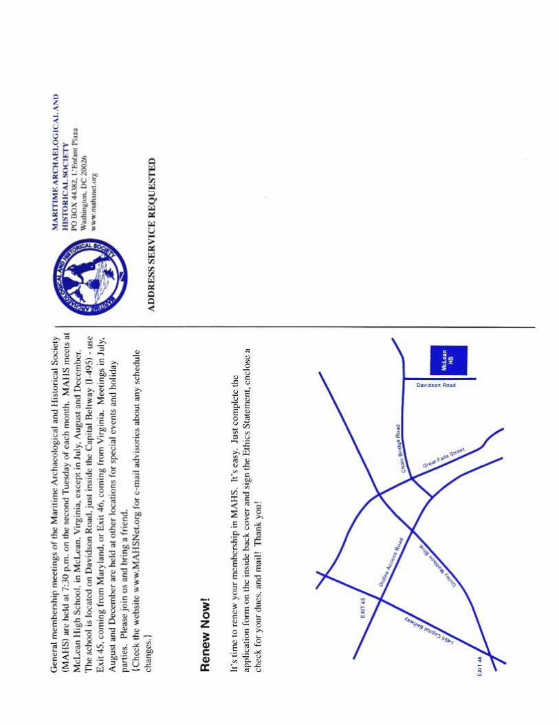
MAHSNEWS Spring 2007 1
Glimpsing Beneath the Waters: A Survey of Jamestown Island’s Submerged Resources By Jodi Carpenter
n December 20, 1606, three ships, the Susan Constant, the Discovery, and the Godspeed, set sail
from London, England for the New World. The voyage was launched by the Virginia Company of London under a charter established by the English Crown as a largely commercial enterprise. Five months later, on May 13, 1607, the colonists disembarked on Jamestown Island, Virginia, and established the first permanent English settlement in the New World. Four hundred years later, in 2007, Jamestown Island observes the quadrennial anniversary of the founding of “James Cittie.”
When the colonists arrived on Jamestown Island there were no native inhabitants living there. However, the surrounding countryside was occupied by Native Americans including the Chicahominy and the Powhatan Confederacy. The Jamestown settlers chose the island because it could easily be defended from attacks by natives as well as from competing European countries. Through much trial
establish a foothold in the New World. For the first one hundred years Jamestown Island served as Virginia’s capital and was an important center of commercial activity. But after the capital moved to Williamsburg in 1699, James Cittie literally faded into the ground and the island became plantation land.
Throughout the following two centuries, numerous contemporary reports spoke of brick foundations eroding into the James River. In 1882, the Association for the Preservation of Virginia Antiquities, the APVA, was founded, and efforts to preserve the first English settlement in the New World began. The church tower was the last vestige of the old town that remained visible above ground and erosion threatened
to destroy it. The APVA acquired over twenty acres surrounding the church tower and the site of the colonist’s original settlement area.
continued on page 3
O
INSIDE THIS ISSUE:
Jamestown Island Survey............................... 1 MAAC Summary............................................ 12 Pensacola Area Shipwrecks ........................... 6 SHA Conference Summary .......................... 14 MAHS Endorses UNESCO Treaty................... 9 ACUA in Williamsburg ................................. 15 Upper Wicomico River................................... 10 Spring Pool Session..................................... 16
MASTHEAD
VOLUME 18, NO.1 SPRING 2007
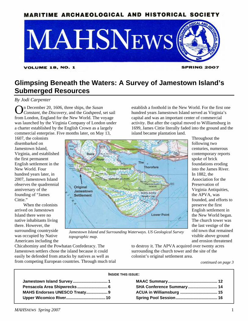
Jamestown Island and Surrounding Waterways. US Geological Survey topographic map.
MAHSNEWS Spring 2007 2
Notes from the Prez – Steven Anthony
It’s a sure sign of spring when the birds start
twittering and the local dive shops report hydro and VIP sales on the rise. This year Old Man Winter treated the East Coast to some of the worst weather in history, but that didn’t deter MAHS members who stayed busier than ever during the “off” season. Here is a synopsis of some of our recent activities and events.
Last December, MAHS learned that Del Tech College, in Delaware, was the recipient of a collection of treasure salvaged from the Atocha shipwreck in the 1980’s. The artifacts had been donated to the College for tax purposes. Instead of keeping the collection intact for public display, the Board of Trustees voted to sell the artifacts at public auction. MAHS joined with academicians around the state in objection to the sale and wrote letters in opposition, but to no avail. The collection was sold in early January with Governor Minner’s support, setting a disgraceful example for the students of the college and the public at large of the crass commercialization of historic artifacts.
Also as part of our advocacy role, MAHS learned that in January the Puerto Rico legislature submitted a bill to their Governor authorizing the issuance of treasure salvage permits to the general public. Juan Vera, the archaeologist for Puerto Rico, called for assistance in opposing this bill. MAHS joined in opposition and submitted a petition denouncing the bill which was, in the end, vetoed by the Governor
Also, in January, I had the honor of representing MAHS at the annual Board of Directors Meeting of the Advisory Council on Underwater Archaeology (ACUA). The meeting was convened contemporaneously with the annual conference of the Society for Historical Archaeology (SHA). ACUA serves as an international advisory body on issues relating to underwater archaeology, conservation, and submerged cultural resources management, and MAHS was recently appointed to serve as an Institutional Associate Member. At the SHA conference, I further represented MAHS as chair of a session entitled Current Perspectives in Maritime Archaeology: Methods and Research, during which I presented a report on the Pamunkey River Project. The report was written by Tom Berkey and Dennis Knepper, and from everything that I heard it was well received by the audience.
On a bitter cold weekend in February, an intrepid team of MAHS volunteers including Tom Berkey, Dennis Knepper, and me met Dr. Susan Langley and Steve Bilicki to examine several wreck sites in the frozen Wicomico River just south of Salisbury,
continued on page 18
MAHSNEWS Spring 2007 3
continued from page 1 and error the English colonists managed to A protective wall was placed along the APVA property to stop erosion from claming the site. The National Park Service, which owns the remaining 1,500 acres of the island, placed rip rap almost entirely around the property to prevent additional loss of shoreline. Erosion, however, continues to be a problem. Historic ceramic sherds can be seen eroding out of one embankment on the Jamestown side of the Back River, and to date there is no protection along the mainland side.
ver the years, the bulk of the archaeological investigations on Jamestown Island have focused
on the island’s terrestrial resources to the neglect of its waterways, which is ironic considering that the human use of Jamestown’s waterways both pre- and postdate seventeenth-century James Cittie. Two underwater
investigations have been conducted: one in 1955 by John Cotter using a clam bucket, screening the dredged material for artifacts; and one by the Virginia Institute of Marine Science using side-scan sonar. Both investigations
concentrated their efforts in the area in front of the APVA property in search of the colonist’s first fort. It was once popular belief that the fort lay off the modern shoreline as a result of sea level rise and erosion. There has been an estimated one meter of sea level rise in the area and one hundred twenty meters or around four hundred feet of shoreline loss in front of the APVA property. Due to the efforts of William Kelso, Director of Archaeology for the APVA since 1993, it is now known that the remnants of the first fort remain largely on the island itself.
n July 2006, underwater archaeologists Steve Bilicki (BRS Research and Survey),
and Jodi Carpenter (East Carolina University [ECU]) designed and conducted a Phase I pre-disturbance side-scan sonar survey in the waters surrounding Jamestown Island. This was the first comprehensive underwater survey encompassing the island’s entire 7.8-mile shoreline. The project was conducted in conjunction with
the National Park Service and Colonial National Historical Park archaeologist Andrew Veech. Undergraduate Steve Brock (Indiana University of Pennsylvania) rounded out the four-person survey team.
While the 2006 survey reexamined the previously surveyed area in front of the APVA, the study concentrated on the previously unexplored Back River, Thorofare, and southern portion of Jamestown Island. Certain shipwrecks had been identified in these areas prior to the 2006 survey. They included several barges in the Back River and the appearance of four wreck symbols on standard navigation charts of the area, one in the Back River, one in the Thorofare, and two south of the island. Although the survey team intended to investigate these wrecks, the ultimate goal was to locate any colonial sites that may have been submerged.
The bulk of the field work was conducted in ten days during July 2006 . The entire island was circum-navigated with the side-scan sonar. Ten survey boxes were set up to encompass the island, each box consisting of twelve lanes from the shoreline out using twenty-five meter spacing. The only exception was the Back River which required only three lanes for complete coverage. The sonar survey, along with a visual search of the shoreline, yielded over 70 potential sites. Several targets were ground-truthed during the survey, while subsequent return trips to the island have provided additional information.
he most immediate and surprising result of the survey was the number of shipwrecks surrounding
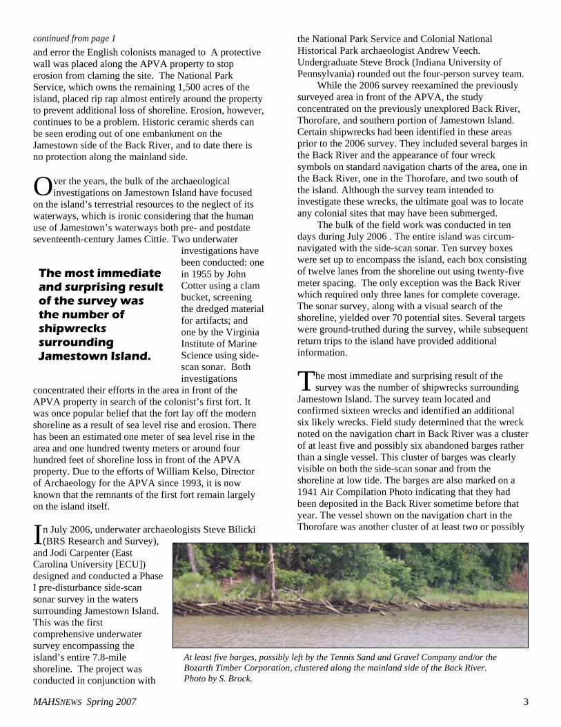
Jamestown Island. The survey team located and confirmed sixteen wrecks and identified an additional six likely wrecks. Field study determined that the wreck noted on the navigation chart in Back River was a cluster of at least five and possibly six abandoned barges rather than a single vessel. This cluster of barges was clearly visible on both the side-scan sonar and from the shoreline at low tide. The barges are also marked on a 1941 Air Compilation Photo indicating that they had been deposited in the Back River sometime before that year. The vessel shown on the navigation chart in the Thorofare was another cluster of at least two or possibly
O
I
T
The most immediate and surprising result of the survey was the number of shipwrecks surrounding Jamestown Island.
At least five barges, possibly left by the Tennis Sand and Gravel Company and/or the Bozarth Timber Corporation, clustered along the mainland side of the Back River. Photo by S. Brock.
MAHSNEWS Spring 2007 4
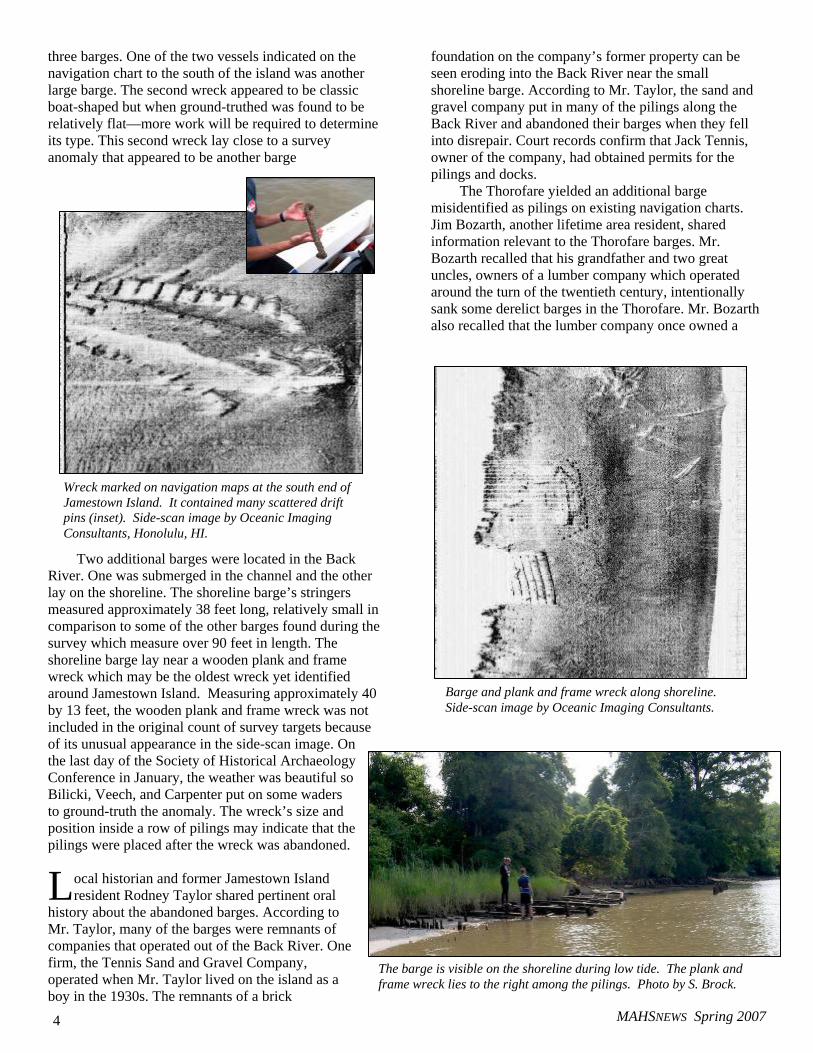
three barges. One of the two vessels indicated on the navigation chart to the south of the island was another large barge. The second wreck appeared to be classic boat-shaped but when ground-truthed was found to be relatively flat—more work will be required to determine its type. This second wreck lay close to a survey anomaly that appeared to be another barge
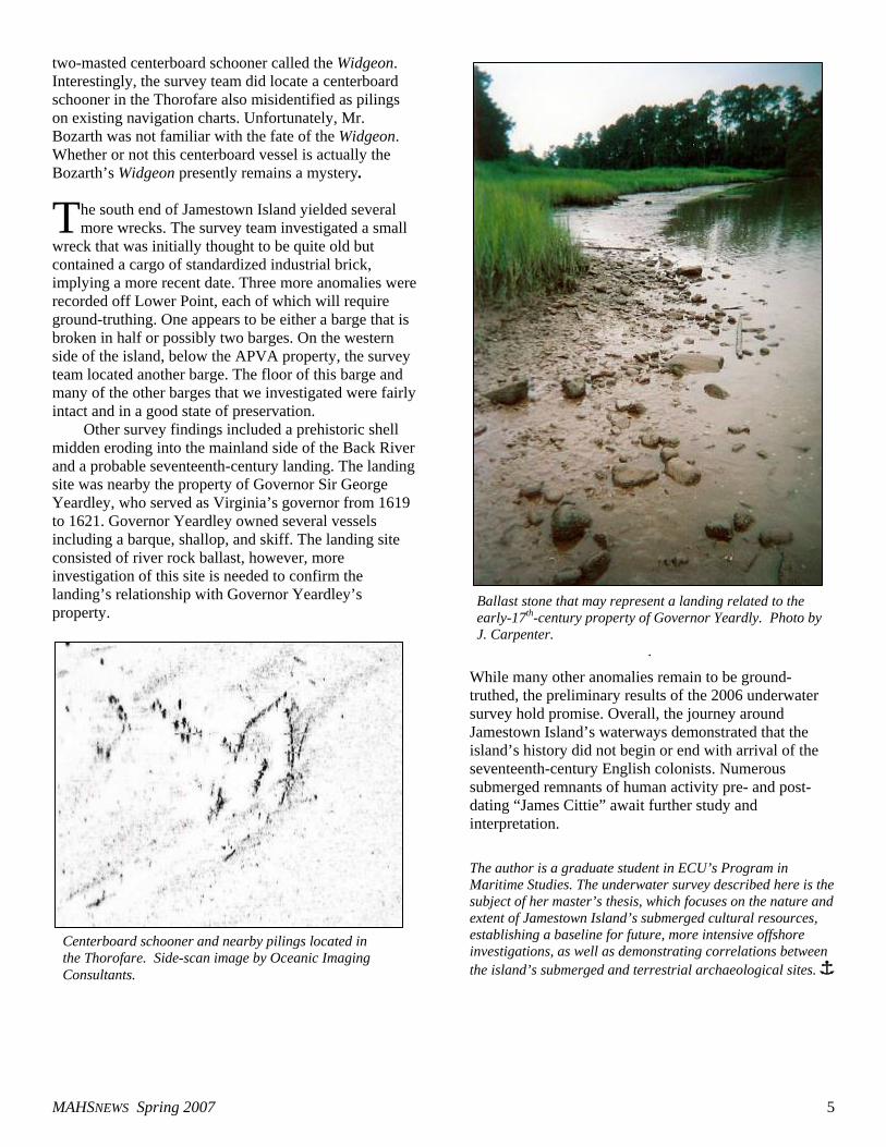
Two additional barges were located in the Back River. One was submerged in the channel and the other lay on the shoreline. The shoreline barge’s stringers measured approximately 38 feet long, relatively small in comparison to some of the other barges found during the survey which measure over 90 feet in length. The shoreline barge lay near a wooden plank and frame wreck which may be the oldest wreck yet identified around Jamestown Island. Measuring approximately 40 by 13 feet, the wooden plank and frame wreck was not included in the original count of survey targets because of its unusual appearance in the side-scan image. On the last day of the Society of Historical Archaeology Conference in January, the weather was beautiful so Bilicki, Veech, and Carpenter put on some waders to ground-truth the anomaly. The wreck’s size and position inside a row of pilings may indicate that the pilings were placed after the wreck was abandoned.
ocal historian and former Jamestown Island resident Rodney Taylor shared pertinent oral
history about the abandoned barges. According to Mr. Taylor, many of the barges were remnants of companies that operated out of the Back River. One firm, the Tennis Sand and Gravel Company, operated when Mr. Taylor lived on the island as a boy in the 1930s. The remnants of a brick
foundation on the company’s former property can be seen eroding into the Back River near the small shoreline barge. According to Mr. Taylor, the sand and gravel company put in many of the pilings along the Back River and abandoned their barges when they fell into disrepair. Court records confirm that Jack Tennis, owner of the company, had obtained permits for the pilings and docks.
The Thorofare yielded an additional barge misidentified as pilings on existing navigation charts. Jim Bozarth, another lifetime area resident, shared information relevant to the Thorofare barges. Mr. Bozarth recalled that his grandfather and two great uncles, owners of a lumber company which operated around the turn of the twentieth century, intentionally sank some derelict barges in the Thorofare. Mr. Bozarth also recalled that the lumber company once owned a
L
Wreck marked on navigation maps at the south end of Jamestown Island. It contained many scattered drift pins (inset). Side-scan image by Oceanic Imaging Consultants, Honolulu, HI.
Barge and plank and frame wreck along shoreline. Side-scan image by Oceanic Imaging Consultants.
The barge is visible on the shoreline during low tide. The plank and frame wreck lies to the right among the pilings. Photo by S. Brock.
MAHSNEWS Spring 2007 5
two-masted centerboard schooner called the Widgeon. Interestingly, the survey team did locate a centerboard schooner in the Thorofare also misidentified as pilings on existing navigation charts. Unfortunately, Mr. Bozarth was not familiar with the fate of the Widgeon. Whether or not this centerboard vessel is actually the Bozarth’s Widgeon presently remains a mystery.
he south end of Jamestown Island yielded several more wrecks. The survey team investigated a small
wreck that was initially thought to be quite old but contained a cargo of standardized industrial brick, implying a more recent date. Three more anomalies were recorded off Lower Point, each of which will require ground-truthing. One appears to be either a barge that is broken in half or possibly two barges. On the western side of the island, below the APVA property, the survey team located another barge. The floor of this barge and many of the other barges that we investigated were fairly intact and in a good state of preservation.
Other survey findings included a prehistoric shell midden eroding into the mainland side of the Back River and a probable seventeenth-century landing. The landing site was nearby the property of Governor Sir George Yeardley, who served as Virginia’s governor from 1619 to 1621. Governor Yeardley owned several vessels including a barque, shallop, and skiff. The landing site consisted of river rock ballast, however, more investigation of this site is needed to confirm the landing’s relationship with Governor Yeardley’s property.
While many other anomalies remain to be ground-truthed, the preliminary results of the 2006 underwater survey hold promise. Overall, the journey around Jamestown Island’s waterways demonstrated that the island’s history did not begin or end with arrival of the seventeenth-century English colonists. Numerous submerged remnants of human activity pre- and post-dating “James Cittie” await further study and interpretation.
The author is a graduate student in ECU’s Program in Maritime Studies. The underwater survey described here is the subject of her master’s thesis, which focuses on the nature and extent of Jamestown Island’s submerged cultural resources, establishing a baseline for future, more intensive offshore investigations, as well as demonstrating correlations between the island’s submerged and terrestrial archaeological sites. Î
T
Centerboard schooner and nearby pilings located in the Thorofare. Side-scan image by Oceanic Imaging Consultants.
Ballast stone that may represent a landing related to the early-17th-century property of Governor Yeardly. Photo by J. Carpenter.
.
MAHSNEWS Spring 2007 6
Shipwrecks and Submerged Cultural Resources In and Around Pensacola, Florida By Douglas Campbell
he Gulf Coast states of Florida, Alabama, Mississippi, Louisiana and Texas have kept their 2,028 miles of beaches a pretty good secret all
these years. From Key West to Brownsville, Texas, this “Redneck Riviera” has been surrounded, for the most part, by sleepy towns intent on living life in the slow lane. Recently though, many of these communities, such as Gulfport with its casinos and all the places affected by recent hurricanes began waking up to the sounds of ringing cash registers and major construction projects. Articles on Gulf Coast diving continue to depict the Pensacola area as a place you would want to pass up for more favored diving spots. This article is about shipwrecks and submerged cultural resources off of oil-rig-free Pensacola. For an underwater archaeologist, some of these fairly shallow wrecks hold enough history to them to make them worthwhile investigations. From tugboats to an aircraft carrier, the bottom of the Gulf of Mexico around Pensacola contains a rich field of wrecks.
Located about as far west as you can go in Florida (it's even in the Central Time Zone), Pensacola lays claim to the whitest and cleanest beaches anywhere along the Gulf Coast and, unknown to many divers, some of the finest diving that the Gulf Coast offers.
The Gulf Coast area is loaded with legends and shipwrecks, from the pirate Jean LaFitte to the Civil War to the World Wars to the most recent hurricanes, natural and man-made catastrophes have created enough interesting dive sites to keep five dive shops in business in Pensacola.
lorida's earliest shipwreck site was discovered in 1992 by a team from the Florida Bureau of Archaeological Research during a survey of
Pensacola Bay. Preliminary excavations at the site, also known as the Emanuel Point Shipwreck, were conducted in conjunction with the Historic Pensacola Preservation Board and the University of West Florida. The
investigations determined the remains to be the lower hull of a Colonial Spanish ship, along with its contents, in a surprising state of preservation. Thus far, over 3,000 artifacts, as well as the remains of plants and animals, have been studied—yet only 20 percent of the site has been explored.
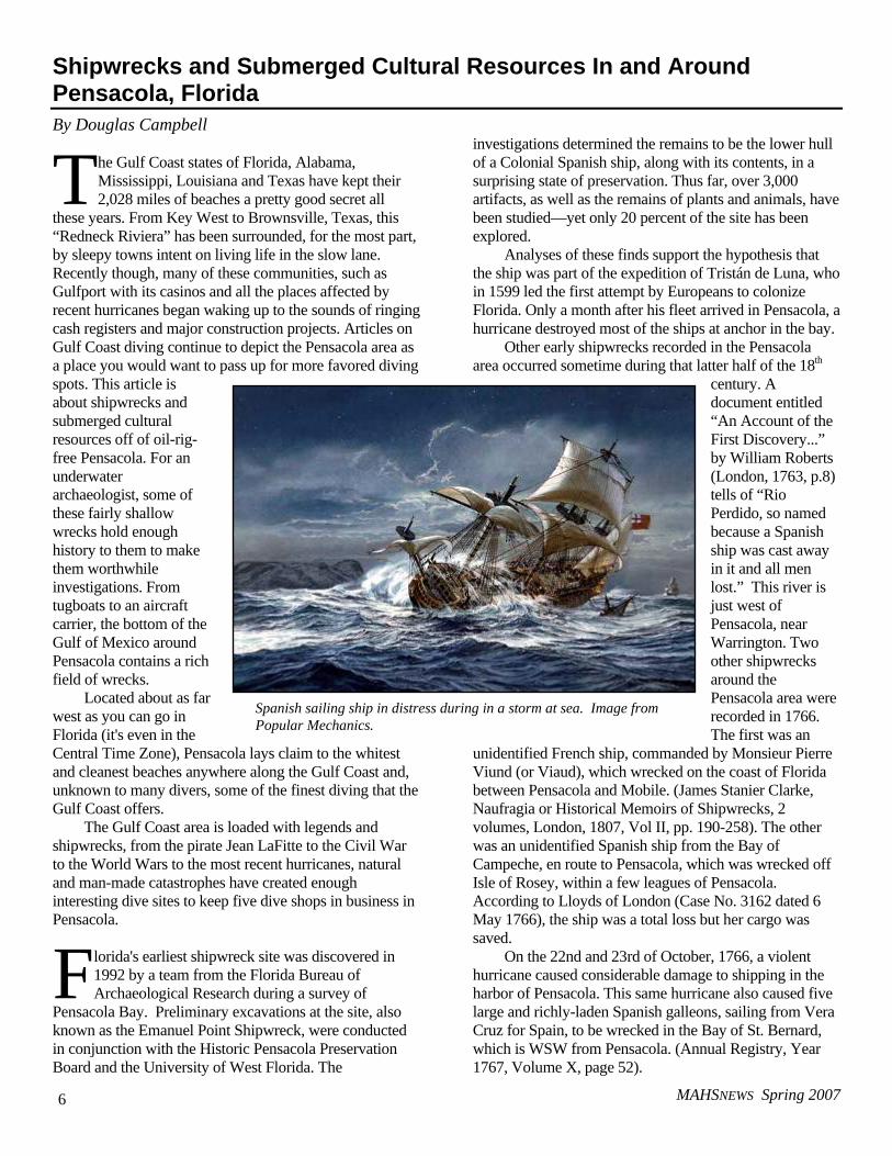
Analyses of these finds support the hypothesis that the ship was part of the expedition of Tristán de Luna, who in 1599 led the first attempt by Europeans to colonize Florida. Only a month after his fleet arrived in Pensacola, a hurricane destroyed most of the ships at anchor in the bay.
Other early shipwrecks recorded in the Pensacola area occurred sometime during that latter half of the 18th
century. A document entitled “An Account of the First Discovery...” by William Roberts (London, 1763, p.8) tells of “Rio Perdido, so named because a Spanish ship was cast away in it and all men lost.” This river is just west of Pensacola, near Warrington. Two other shipwrecks around the Pensacola area were recorded in 1766. The first was an
unidentified French ship, commanded by Monsieur Pierre Viund (or Viaud), which wrecked on the coast of Florida between Pensacola and Mobile. (James Stanier Clarke, Naufragia or Historical Memoirs of Shipwrecks, 2 volumes, London, 1807, Vol II, pp. 190-258). The other was an unidentified Spanish ship from the Bay of Campeche, en route to Pensacola, which was wrecked off Isle of Rosey, within a few leagues of Pensacola. According to Lloyds of London (Case No. 3162 dated 6 May 1766), the ship was a total loss but her cargo was saved.
On the 22nd and 23rd of October, 1766, a violent hurricane caused considerable damage to shipping in the harbor of Pensacola. This same hurricane also caused five large and richly-laden Spanish galleons, sailing from Vera Cruz for Spain, to be wrecked in the Bay of St. Bernard, which is WSW from Pensacola. (Annual Registry, Year 1767, Volume X, page 52).
T
F
Spanish sailing ship in distress during in a storm at sea. Image from Popular Mechanics.
MAHSNEWS Spring 2007 7
Another incident reportedly occurred two years later, on October 9, 1778. In total, 14 ships of various tonnage were lost. Among them were the Sarah (or Sara) & Elizabeth, commanded by Captain Tovet and laden with lumber for Jamaica, and the Mary commanded by Captain Blackwell, both of British registry. (Lloyds of London Case No. 1039 dated 9 March 1779).
Three years later, on April 19, 1781, the Spanish frigate Francesca, commanded by Captain Andromaca and carrying a large cargo of war materials, ran aground on a shoal just inside Pensacola Bay. The exact location of this shipwreck is shown on a chart in the Naval Museum of Madrid. (Museo Naval, Madrid, Seccion de Mapas, Grupo VI, Carpeta B, No. 8, entitled Plano de la Bahia de Panzacola, c. 1781).
Also in 1781, the 20-gun British warship HMS Mentor, commanded by Captain Robert Deans, was burned at Pensacola (William L. Clowes, The Royal Navy, Vol IV - 1897-1903, page 111).
he 19th century saw additional wrecks in Pensacola Bay. In 1814, the Spanish ship Intrepido, commanded by Alferez de Navio Marques (or
Margues) del Moral, was wrecked on Pensacola Beach during a storm. (Fernandez Casareo de Duro, La Armada Espanol 1895-1903, Volume IX, page 407). The vessel as a class of ship identified as a “falacho” or “falucho”. In either an interesting coincidence or an historical mistake, another falacho, also named Intrepido but commanded by Jose Usel de Guimbarda, was lost in Pensacola Bay in 1823. (ibid, page 410).
On March 25, 1815, the Spanish “goleta” Volador, commanded by Captain Joaquin Veal and boasting 10 cannon, entered Pensacola Bay carrying a large cargo of goods and rifles. That night a strong wind came up causing the ship to lurch into the shore and become stranded. It soon went to pieces and two of the crew and all its cargo were lost. (Cesareo Fernandez Duro, Naufragios de la Armada Espanola, Madrid, 1904, page 219).
In 1821, a hurricane on September 15th caused several ships of unknown tonnage to sink in Pensacola Bay. (Ludlum, 1963, page 140). During a hurricane on July 7th, 1822, the sloop Lady Washington ran aground on Ship Island near Pensacola (Ludlum, 1963, page 140).
The American Civil War accounted for several wrecks in the Pensacola area. Continuing research by the author shows that many were sunk in the Pensacola Bay area but were later raised to continue their sailing adventures. One ship that has been located is a 100-ton Confederate schooner named Aid. This ship was captured on June 5, 1861, while salvaging a recently-wrecked vessel just inside the bar off Mobile, Alabama. The USS Niagara, captained by William W. McKean, came alongside, sent a three-boat expedition over to the Aid and captured her. The
ship was taken to the pass at the east end of Santa Rosa Island and scuttled as an obstruction on August 23, 1861.
Later wrecks identified near Pensacola include the sailing ship Bride of Lorne, which went down on April 8, 1887. What is left of the 1,324-ton ship is now located in 25 feet of water just outside the entrance to Pensacola Bay. This ship and others that follow are shown as 'shipwrecks' or 'obstructions to navigation' on National Oceanic and Atmospheric Administration (NOAA) charts.
The next oldest named shipwreck site in the Pensacola area is the sailing ship Eastern Light. Of unknown tonnage, she wrecked on Caucus Shoal while trying to enter Pensacola Bay on December 23, 1890. Little remains of her as she grounded onto the beach into what is now 4-to-8 feet of water. It is unknown whether any ballast or remains of her hull exist.
Less than two months after the Eastern Light grounded while entering the Bay, the barkentine Hattie G. McFarland was wrecked nearby. The remains of this 546-ton vessel now lie in about 50 feet of water.
On July 19, 1896, the 620-ton barkentine Anna Peppina wrecked attempting entry through the Pensacola Bay pass. Her remains lie in 8 feet of water on the Middle Ground at the entry to the pass. An unidentified wreck lies just to the north-northeast of her, closer to Santa Rosa Island and also in 8 feet of water.
Several years later, on February 1, 1899, the 391-ton four-masted schooner James Baird was blown onto Santa Rosa Island and wrecked. Her crew was rescued by a U.S. Coast Guard breeches buoy. The first photograph of a Pensacola-area shipwreck was taken of the James Baird by the Coast Guard. Presently, the site is accessible from the beach, but heavy surf tends to keep visibility to a minimum.
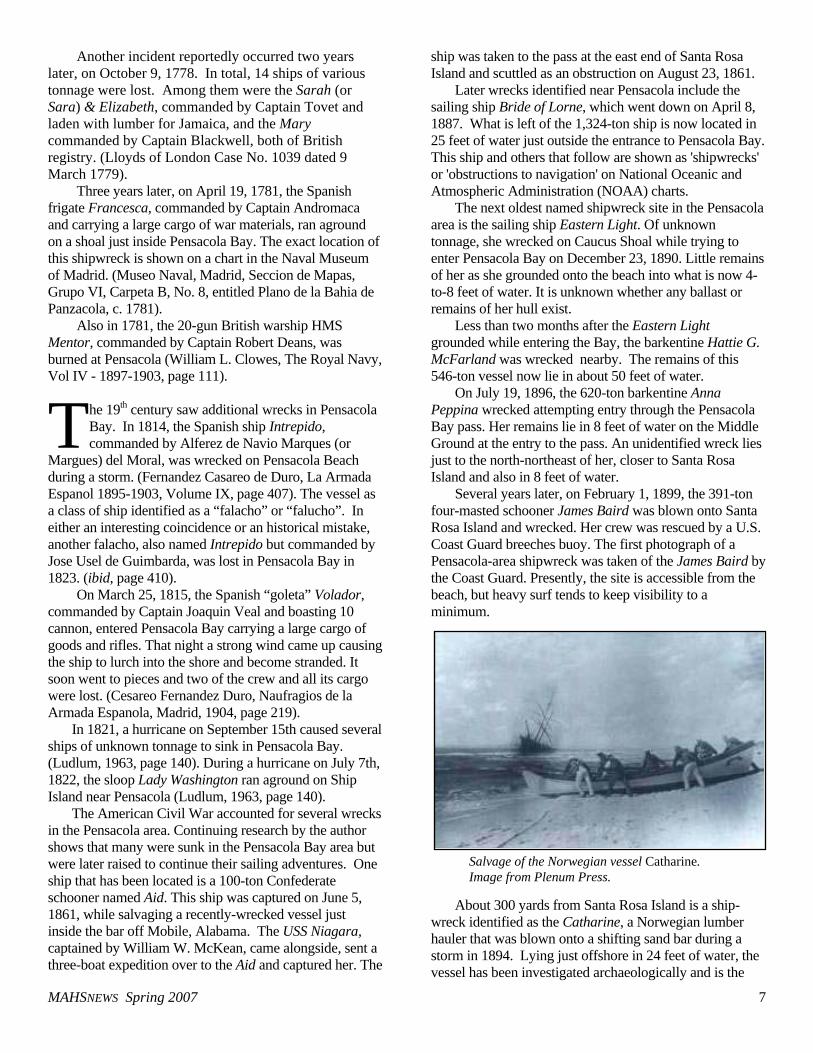
About 300 yards from Santa Rosa Island is a ship-wreck identified as the Catharine, a Norwegian lumber hauler that was blown onto a shifting sand bar during a storm in 1894. Lying just offshore in 24 feet of water, the vessel has been investigated archaeologically and is the
T
Salvage of the Norwegian vessel Catharine. Image from Plenum Press.
MAHSNEWS Spring 2007 8
subject of a book by Jason Burns entitled The Life and Times of a Merchant Sailor: The Archaeology and History of the Norwegian Ship "Catharine" (Plenum Press, reviewed in MAHSNEWS 17[1], Spring 2006). The wreck lies outside the surf line, but all that remains of her are badly deteriorated beams and her ballast rock.
Two other ships known to have sunk during a hurricane in 1906 are unnamed, but local divers have come to call them the Side Wheeler Wreck and the Whiskey Wreck or Mail Wreck. The Side Wheeler Wreck originally sank about 100 yards offshore. The position is now just under one-half mile offshore due to the receding shore line along Perdido Key. Parts of the boiler and unidentified pieces of the rest of the ship remain under 24 feet of water. The remains of the Whiskey Wreck lie further to the west, in nearby Gulf Shores, Alabama. Lying in 15 to 20 feet of water, the wreck is a popular shore dive, home to a wide range of marine life and a favorite location for shell collectors.
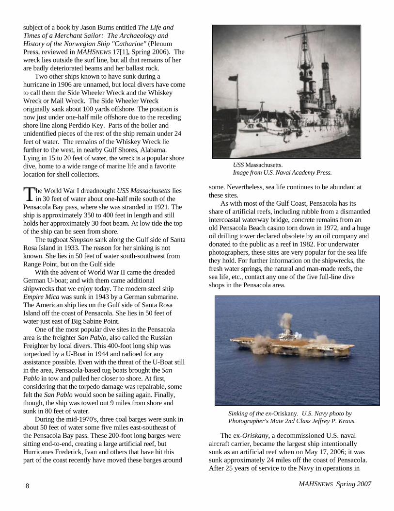
he World War I dreadnought USS Massachusetts lies in 30 feet of water about one-half mile south of the
Pensacola Bay pass, where she was stranded in 1921. The ship is approximately 350 to 400 feet in length and still holds her approximately 30 foot beam. At low tide the top of the ship can be seen from shore.
The tugboat Simpson sank along the Gulf side of Santa Rosa Island in 1933. The reason for her sinking is not known. She lies in 50 feet of water south-southwest from Range Point, but on the Gulf side
With the advent of World War II came the dreaded German U-boat; and with them came additional shipwrecks that we enjoy today. The modern steel ship Empire Mica was sunk in 1943 by a German submarine. The American ship lies on the Gulf side of Santa Rosa Island off the coast of Pensacola. She lies in 50 feet of water just east of Big Sabine Point.
One of the most popular dive sites in the Pensacola area is the freighter San Pablo, also called the Russian Freighter by local divers. This 400-foot long ship was torpedoed by a U-Boat in 1944 and radioed for any assistance possible. Even with the threat of the U-Boat still in the area, Pensacola-based tug boats brought the San Pablo in tow and pulled her closer to shore. At first, considering that the torpedo damage was repairable, some felt the San Pablo would soon be sailing again. Finally, though, the ship was towed out 9 miles from shore and sunk in 80 feet of water.
During the mid-1970's, three coal barges were sunk in about 50 feet of water some five miles east-southeast of the Pensacola Bay pass. These 200-foot long barges were sitting end-to-end, creating a large artificial reef, but Hurricanes Frederick, Ivan and others that have hit this part of the coast recently have moved these barges around
some. Nevertheless, sea life continues to be abundant at these sites.
As with most of the Gulf Coast, Pensacola has its share of artificial reefs, including rubble from a dismantled intercoastal waterway bridge, concrete remains from an old Pensacola Beach casino torn down in 1972, and a huge oil drilling tower declared obsolete by an oil company and donated to the public as a reef in 1982. For underwater photographers, these sites are very popular for the sea life they hold. For further information on the shipwrecks, the fresh water springs, the natural and man-made reefs, the sea life, etc., contact any one of the five full-line dive shops in the Pensacola area.
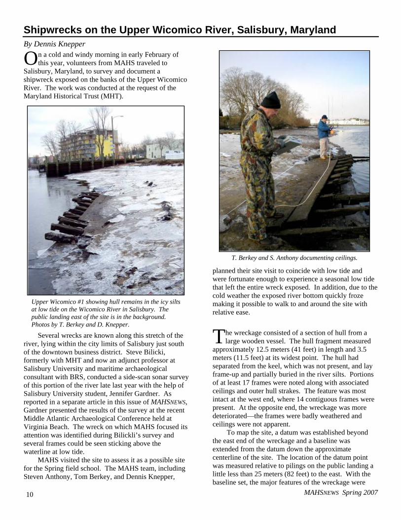
The ex-Oriskany, a decommissioned U.S. naval aircraft carrier, became the largest ship intentionally sunk as an artificial reef when on May 17, 2006; it was sunk approximately 24 miles off the coast of Pensacola. After 25 years of service to the Navy in operations in
T
USS Massachusetts. Image from U.S. Naval Academy Press.
Sinking of the ex-Oriskany. U.S. Navy photo by Photographer's Mate 2nd Class Jeffrey P. Kraus.

MAHSNEWS Spring 2007 9
Korea, Vietnam and the Mediterranean, ex-Oriskany is now benefiting marine life, sport fishing and some hard-core SCUBA divers.
The 888-foot ship took about 37 minutes to sink after strategically placed explosives were detonated. The Navy sank the 32,000 ton aircraft carrier upright on the ocean floor in a north-south orientation at an existing artificial reef site at a depth of approximately 212
feet. The flight deck lies at a depth of approximately 100 feet.
Special thanks for information in this article are due to the
Pensacola Chamber of Commerce; Scuba Shack, Pensacola, Florida; and John Campbell, also of Pensacola. More information on the Tristan de Luna expedition is available at http://www.de-luna.com/pal.html Î
MAHS Endorses the ICOMOS Charter and Rules Annexed to the UNESCO Convention
n February of this year, the Board of directors of the Maritime Archaeological and Historical Society voted
to formally endorse the ICOMOS Charter and rules annexed to the UNESCO Convention on the Protection of the Underwater Cultural Heritage.
As background, the 11th General Assembly of ICOMOS, the International Council on Monuments and Sites, meeting in Sofia, Bulgaria, in October 1996, ratified a document know as the Charter on the Protection and Management of Underwater Cultural Heritage. The charter was an outgrowth of the 1990 ICOMOS Charter for the Protection and Management of the Archaeo-logical Heritage, which provided a set of standards for the investigation, maintenance, and preservation of terrestrial archaeological heritage sites. The underwater document ex-tends the same formal standards to, in the words of the Charter’s preface, “submerged sites and structures, wreck-sites and wreckage and their archaeological and natural context.” The Charter contains 15 articles with subjects ranging from fundamental principles to project design, funding, qualifications of personnel, conser-vation, health and safety, and reporting and dissemination.
The more recent UNESCO Convention was adopted in Paris on November 2, 2001, by the Plenary session of the 31st General Conference of the United Nations Educational, Scientific and Cultural Organization (UNESCO). Its provisions call for similar protections and standards for treatment of underwater cultural heritage sites. As stated in a public release, “the Convention on the Protection of the Underwater Cultural Heritage is an international legal instrument for general
application that provides a high level of protection for the underwater cultural heritage. By ratifying the Convention, the States Parties undertake to adopt the necessary measures (while benefiting themselves from measures taken by the other States Parties) to safeguard the underwater cultural heritage for the good of humanity using the most appropriate means at their disposal and to the best of their abilities.”
he U.S. State Department, the National Oceanic and Atmospheric Administration, the National Park
Service, and several states such as Maryland have all expressed support for the ICOMOS Charter. Unlike certain articles of the Convention, the Charter does not involve political or legal issues, but rather represents a codification of international scientific standards, requirements and principles that professional archaeologists and historians have agreed to follow when conducting research and recovery of underwater cultural heritage.
By endorsing the ICOMOS Charter and rules annexed to the
Convention, MAHS supports and promotes minimum internationally accepted and adhered to international professional scientific standards for the treatment and scientific investigation of our global underwater cultural heritage.
The full text of the Convention can be found at http://www. unesco.org/culture/legalprotection/water/html_eng/ convention.shtml Text of the ICOMONS Charter is available at http://www. international.icomos.org/charters/underwater_e.htm Î
I
T
MAHSNEWS Spring 2007 10
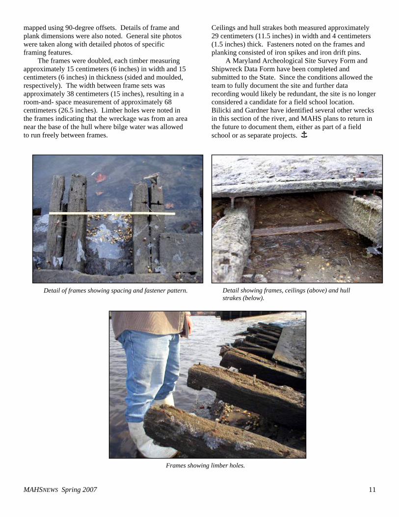
Shipwrecks on the Upper Wicomico River, Salisbury, Maryland By Dennis Knepper
n a cold and windy morning in early February of this year, volunteers from MAHS traveled to
Salisbury, Maryland, to survey and document a shipwreck exposed on the banks of the Upper Wicomico River. The work was conducted at the request of the Maryland Historical Trust (MHT).
Several wrecks are known along this stretch of the river, lying within the city limits of Salisbury just south of the downtown business district. Steve Bilicki, formerly with MHT and now an adjunct professor at Salisbury University and maritime archaeological consultant with BRS, conducted a side-scan sonar survey of this portion of the river late last year with the help of Salisbury University student, Jennifer Gardner. As reported in a separate article in this issue of MAHSNEWS, Gardner presented the results of the survey at the recent Middle Atlantic Archaeological Conference held at Virginia Beach. The wreck on which MAHS focused its attention was identified during Bilickli’s survey and several frames could be seen sticking above the waterline at low tide.
MAHS visited the site to assess it as a possible site for the Spring field school. The MAHS team, including Steven Anthony, Tom Berkey, and Dennis Knepper,
planned their site visit to coincide with low tide and were fortunate enough to experience a seasonal low tide that left the entire wreck exposed. In addition, due to the cold weather the exposed river bottom quickly froze making it possible to walk to and around the site with relative ease.
he wreckage consisted of a section of hull from a large wooden vessel. The hull fragment measured
approximately 12.5 meters (41 feet) in length and 3.5 meters (11.5 feet) at its widest point. The hull had separated from the keel, which was not present, and lay frame-up and partially buried in the river silts. Portions of at least 17 frames were noted along with associated ceilings and outer hull strakes. The feature was most intact at the west end, where 14 contiguous frames were present. At the opposite end, the wreckage was more deteriorated—the frames were badly weathered and ceilings were not apparent.
To map the site, a datum was established beyond the east end of the wreckage and a baseline was extended from the datum down the approximate centerline of the site. The location of the datum point was measured relative to pilings on the public landing a little less than 25 meters (82 feet) to the east. With the baseline set, the major features of the wreckage were
O
T
T. Berkey and S. Anthony documenting ceilings.
Upper Wicomico #1 showing hull remains in the icy silts at low tide on the Wicomico River in Salisbury. The public landing east of the site is in the background. Photos by T. Berkey and D. Knepper.
MAHSNEWS Spring 2007 11
mapped using 90-degree offsets. Details of frame and plank dimensions were also noted. General site photos were taken along with detailed photos of specific framing features.
The frames were doubled, each timber measuring approximately 15 centimeters (6 inches) in width and 15 centimeters (6 inches) in thickness (sided and moulded, respectively). The width between frame sets was approximately 38 centimeters (15 inches), resulting in a room-and- space measurement of approximately 68 centimeters (26.5 inches). Limber holes were noted in the frames indicating that the wreckage was from an area near the base of the hull where bilge water was allowed to run freely between frames.
Ceilings and hull strakes both measured approximately 29 centimeters (11.5 inches) in width and 4 centimeters (1.5 inches) thick. Fasteners noted on the frames and planking consisted of iron spikes and iron drift pins.
A Maryland Archeological Site Survey Form and Shipwreck Data Form have been completed and submitted to the State. Since the conditions allowed the team to fully document the site and further data recording would likely be redundant, the site is no longer considered a candidate for a field school location. Bilicki and Gardner have identified several other wrecks in this section of the river, and MAHS plans to return in the future to document them, either as part of a field school or as separate projects. Î
Detail of frames showing spacing and fastener pattern. Detail showing frames, ceilings (above) and hull strakes (below).
Frames showing limber holes.
MAHSNEWS Spring 2007 12
The 2007 Middle Atlantic Archaeological Conference, or a Barge by Any Other Name
he 37th annual Middle Atlantic Archaeological Conference was held in Virginia Beach on a cold
and rainy St. Patrick’s Day weekend. As has been the case in the last few years, the meeting included a full session of maritime archaeology papers, again ably assembled and chaired by Stephen Bilicki, of BRS. Several of this year’s presentations dealt with the Roosevelt Inlet Shipwreck, the remains of an 18th-century merchant ship in Lewes, Delaware, while many of the others had a common but somewhat more prosaic theme—barges.
The session began with a presentation by MAHS members Bill Utley and Ray Hayes, who for the past several years have been working with MAHS advisor Gordon Watts and the Institute for International Maritime Research in a search for the original site of the Lost Colony on Roanoke Island on the Outer Banks of North Carolina. Records generally place the settlement at the north end of the island, although the specific location is not clear. Terrestrial surveys over the years have failed to find any evidence of the settlement. Due to extensive shoreline erosion, the team believes that the most likely place to look is in the water immediately offshore. An article detailing the methods used in the survey appeared in the Fall 2005 issue of MAHSNEWS (Vol. 16 No. 2). Evidence of the settlement is still elusive, but plans have been laid for the ongoing search.
eports on the Roosevelt Inlet Shipwreck began with Michael Krivor, of SEARCH (Southeast
Archaeological Research, Inc.), who presented a summary of a data recovery investigation conducted at the site in the Fall of 2006. An article by Krivor detailing the investigation appeared in the Fall 2006 issue of MAHSNEWS (Vol. 17 No. 2). Using a combination of remote sensing, a hydro-probe survey, controlled surface collection, and excavation, the component features of the wreck were defined and over 30,000 artifacts recovered. Dan Griffith, Lewes Maritime Archaeology Project Director for the State of Delaware, and Chuck Fithian, Curator of Archaeology for the Delaware State Museums, discussed current interpretations of the wreck. Delaware holds a massive artifact collection from the site, including the 30,000 items recovered during the SEARCH investigation and over 40,000 items collected from the sands pumped onto
the beach during the dredging operation that disturbed the site in the Fall of 2004. The date ranges of certain ceramic types in the collection narrowed the time of the wreck to a relatively short span from 1772-1779. Archival records indicate only one merchant vessel was lost in the area during that period: the Severn, Captain James Hathorn, a 200-ton Bristol-built ship owned by Thomas Pennington that ran aground off Cape Henlopen in 1774. Evidence thus suggests that the wreck is that of the Severn
Among the many artifact types recovered from the Roosevelt Island Wreck was a collection of small tin soldiers manufactured in Germany in the so-called Nuremburg flat tradition. Craig Lukezic, an archaeologist with the Delaware Department of Historic Resources, described the collection, characterizing it as “the invasion that never happened.” He noted that the styles of the soldiers and several ship models found along with them did not necessarily indicate their date of manufacture, but probably commemorated or illustrated armies of earlier wars.
ave Howe, of the Institute of Maritime History, presented an update of the SHIP program. The
Submerged Historical Inventory Project is a long-term reconnaissance of potential underwater historic resources in Maryland, Delaware, and other states. Findings are compiled into databases to help the states build inventories of historic sites in their waters, and to protect and manage those sites. Howe indicated that with a small side-scan sonar, he and volunteer crews have surveyed sections of the Potomac River as far as Breton Bay and have conducted a survey of the waterfront at New Castle, Delaware. The project is long-term. Howe estimated that only about two percent of the sites in Maryland and four percent of the sites in Delaware waters thus far have been investigated. Among the more easily identifiable targets located to date were several barges, including a steel tank barge, STC-410, that sank of the Piney Point oil terminal in 1986.
The tank barge was the subject of a presentation by Todd Plaia and D. Emerson of the American Type Culture Collection, a bio-research firm based in Manassas, Virginia. Plaia’s research concerns the role of micro-organisms in the iron cycle, or the oxidation and corrosion of submerged iron objects. Research has
T
R
D
MAHSNEWS Spring 2007 13
shown that oxidation or rusting of iron underwater is not just a mineral process. A wide variety of bacteria make their living eating metal. The process is important to modern industry because of the impact of corrosion on various forms of submerged machinery, such as pipes, tanks, and cooling towers. Shipwrecks are also of interest to the researchers since wrecks often represent metal samples that have been submerged for long periods. Plaia and his associates collected corrosion samples from STC-410 and from the German submarine U-1105, that lie relatively close together near the mouth of the Potomac River. They analyzed the samples via cultures grown on clean steel plates and using 16S rDNA analysis. Preliminary results indicate that several species of iron-oxidizing bacteria are indeed present and that they show differences that may depend on the depth of the wreck (influencing the amount of ambient light available to the bacteria) and the length of time the wreck has been submerged.
odi Carpenter, a graduate student at East Carolina University, presented the findings of a survey she
conducted in association with the National Park Service and Colonial National Historical Park of the waters surrounding Jamestown Island. The findings of the survey are detailed in the lead article in this issue of MAHSNEWS. While wharves, a centerboard schooner, and a plank-on-frame vessel were among the large number of submerged items found and identified, by far the most numerous finds were barges, often discovered in clusters or even stacked on top of one another.
Jennifer Garnder, a student at Salisbury University, presented the results of a recent survey of the Wicomico River that included discovery of at least 15 wrecks, including vessels at Patrick’s Landing and Gumby Landing. Four additional wrecks were identified near the public landing in Salisbury, one of which was the subject of an earlier article in this issue of the newsletter. While at least two of the wrecks appear to be
centerboard vessels and several others may be some form of plank-on-frame vessel, many of the wrecks consist of barge remains.
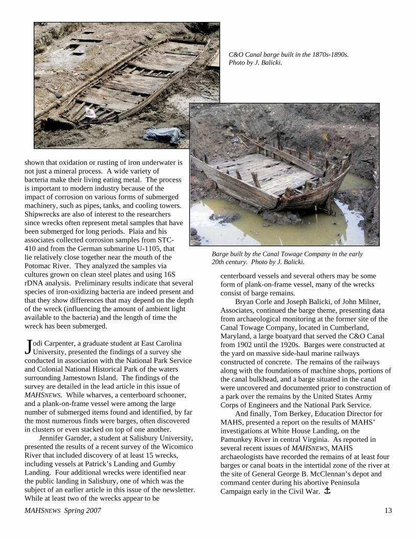
Bryan Corle and Joseph Balicki, of John Milner, Associates, continued the barge theme, presenting data from archaeological monitoring at the former site of the Canal Towage Company, located in Cumberland, Maryland, a large boatyard that served the C&O Canal from 1902 until the 1920s. Barges were constructed at the yard on massive side-haul marine railways constructed of concrete. The remains of the railways along with the foundations of machine shops, portions of the canal bulkhead, and a barge situated in the canal were uncovered and documented prior to construction of a park over the remains by the United States Army Corps of Engineers and the National Park Service.
And finally, Tom Berkey, Education Director for MAHS, presented a report on the results of MAHS’ investigations at White House Landing, on the Pamunkey River in central Virginia. As reported in several recent issues of MAHSNEWS, MAHS archaeologists have recorded the remains of at least four barges or canal boats in the intertidal zone of the river at the site of General George B. McClennan’s depot and command center during his abortive Peninsula Campaign early in the Civil War. Î
J
C&O Canal barge built in the 1870s-1890s. Photo by J. Balicki.
Barge built by the Canal Towage Company in the early 20th century. Photo by J. Balicki.
MAHSNEWS Spring 2007 14
MAHS Attends SHA Conference in Williamsburg, Virginia By James Smailes
he 40th Annual Conference on Historical and Underwater Archaeology (SHA) was held in
Williamsburg, Virginia, January 10–14, 2007. The theme of the conference was Old World/New World: Culture in Transformation. Central to the conference theme was the historical archaeology of Jamestown, especially in the context of the emerging 16th and 17th-century Atlantic world. In fact, the archaeology conference was the first major event marking the 400th Anniversary of the founding of Jamestown, the first permanent English settlement in North America. The conference was one of the largest SHA meetings held, attracting more than 1,500 attendees with more than 700 papers delivered.
The opening plenary session Thursday morning, led by historian Dr. Alan Taylor, set the tone for the conference by focusing on the archaeology of the early decades of European expansion and what has been learned about the cultural exchange among the native peoples, Europeans, and Africans brought to work the land. A special highlight of the conference was an evening tour of the newly opened Jamestown Visitors Center, the James Fort archaeological excavations, and the new exhibits from Bill Kelso’s Jamestown Rediscovery Project.
One of the first sessions on Friday was entitled General Perspectives in Maritime Archaeology: Methods and Research, chaired by MAHS President Steve Anthony. Six papers were presented in the session. The wide range of topics included a presentation on iconographic evidence of Iberian ships of discovery as it appears in the historical record, presented by Katie Custer, of Texas A&M University. Relatively little is known about the caravel and the nao, the two ships that defined the age of Portuguese and Spanish exploration. Custer’s sources for research were the numerous printed materials, works of art, and shipping reports from the age of exploration that used drawings to illustrate the ships being used. By comparing basic dimensions and relationships between overall length, height, beam and so forth, Custer analyzed the depictions of the vessels in the iconographic record, statistically differentiating
between the vessel types. By confirming the reliability of the imagery, Custer hopes to begin documenting technological changes in ship design as reflected in the contemporary art of the period. Jodi Carpenter, of East Carolina University, presented the results of a survey of the waters surrounding Jamestown Island and the submerged resources contained in them. Details of her presentation appear in a separate article in this issue of MAHSNEWS.
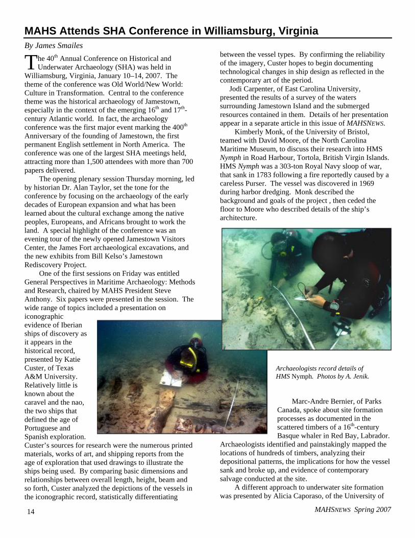
Kimberly Monk, of the University of Bristol, teamed with David Moore, of the North Carolina Maritime Museum, to discuss their research into HMS Nymph in Road Harbour, Tortola, British Virgin Islands. HMS Nymph was a 303-ton Royal Navy sloop of war, that sank in 1783 following a fire reportedly caused by a careless Purser. The vessel was discovered in 1969 during harbor dredging. Monk described the background and goals of the project , then ceded the floor to Moore who described details of the ship’s architecture.
Marc-Andre Bernier, of Parks Canada, spoke about site formation processes as documented in the scattered timbers of a 16th-century Basque whaler in Red Bay, Labrador.
Archaeologists identified and painstakingly mapped the locations of hundreds of timbers, analyzing their depositional patterns, the implications for how the vessel sank and broke up, and evidence of contemporary salvage conducted at the site.
A different approach to underwater site formation was presented by Alicia Caporaso, of the University of
T
Archaeologists record details of HMS Nymph. Photos by A. Jenik.
MAHSNEWS Spring 2007 15
Rhode Island. Caporaso’s analysis focused on the preservation of archaeological materials from Thunder Bay National Marine Sanctuary. Caporaso developed a new model for marine archaeological landscape formation that assesses the probability of three variables: that a vessel will wreck at a given location, that material from the wreck will occur at that location, and that the material will remain or survive there. The model is seen as more cognizant of environmental conditions than existing models of underwater archaeological site formation.
Finally, Steve Anthony gave a presentation on the MAHS Pamunkey River Project, illustrating the remains of canal boats, scows, and schooners used during George B.McLellan’s Peninsula Campaign. The Pamunkey Project has been the subject of several articles in past issues of MAHSNEWS.
On Saturday afternoon, the conference was opened as usual to the public. The public archaeological session is always a popular event, and it was well attended again this year, attracting an audience that ranged from parents and children to teachers and others interested in archaeology. Sponsored by the Virginia Department of Historic Resources and the Maryland Historical Trust, the session highlighted public archaeology in the Chesapeake and Middle Atlantic regions. The opening address was given by noted historical archaeologist, Ivor Noël Hume, in which he discussed archaeology in Virginia—its history and significance. The talk and the session in general were especially well received by the audience.
This year’s conference was a great success. Plans are in the works for next year’s conference, to be held in Albuquerque. Î
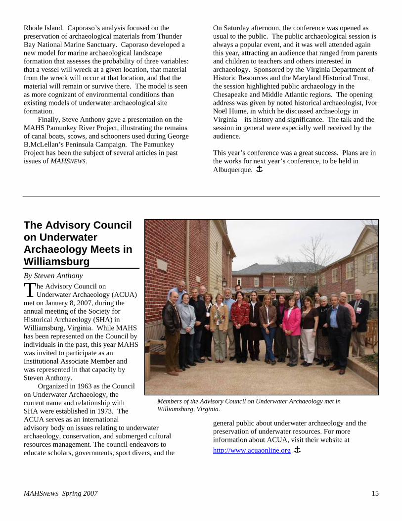
The Advisory Council on Underwater Archaeology Meets in Williamsburg By Steven Anthony
he Advisory Council on Underwater Archaeology (ACUA)
met on January 8, 2007, during the annual meeting of the Society for Historical Archaeology (SHA) in Williamsburg, Virginia. While MAHS has been represented on the Council by individuals in the past, this year MAHS was invited to participate as an Institutional Associate Member and was represented in that capacity by Steven Anthony.
Organized in 1963 as the Council on Underwater Archaeology, the current name and relationship with SHA were established in 1973. The ACUA serves as an international advisory body on issues relating to underwater archaeology, conservation, and submerged cultural resources management. The council endeavors to educate scholars, governments, sport divers, and the
general public about underwater archaeology and the preservation of underwater resources. For more information about ACUA, visit their website at http://www.acuaonline.org Î
T
Members of the Advisory Council on Underwater Archaeology met in Williamsburg, Virginia.
MAHSNEWS Spring 2007 16
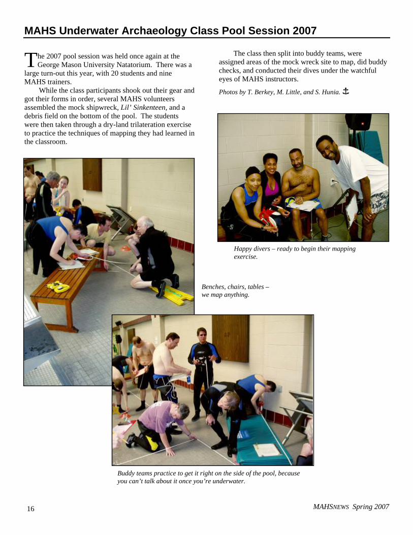
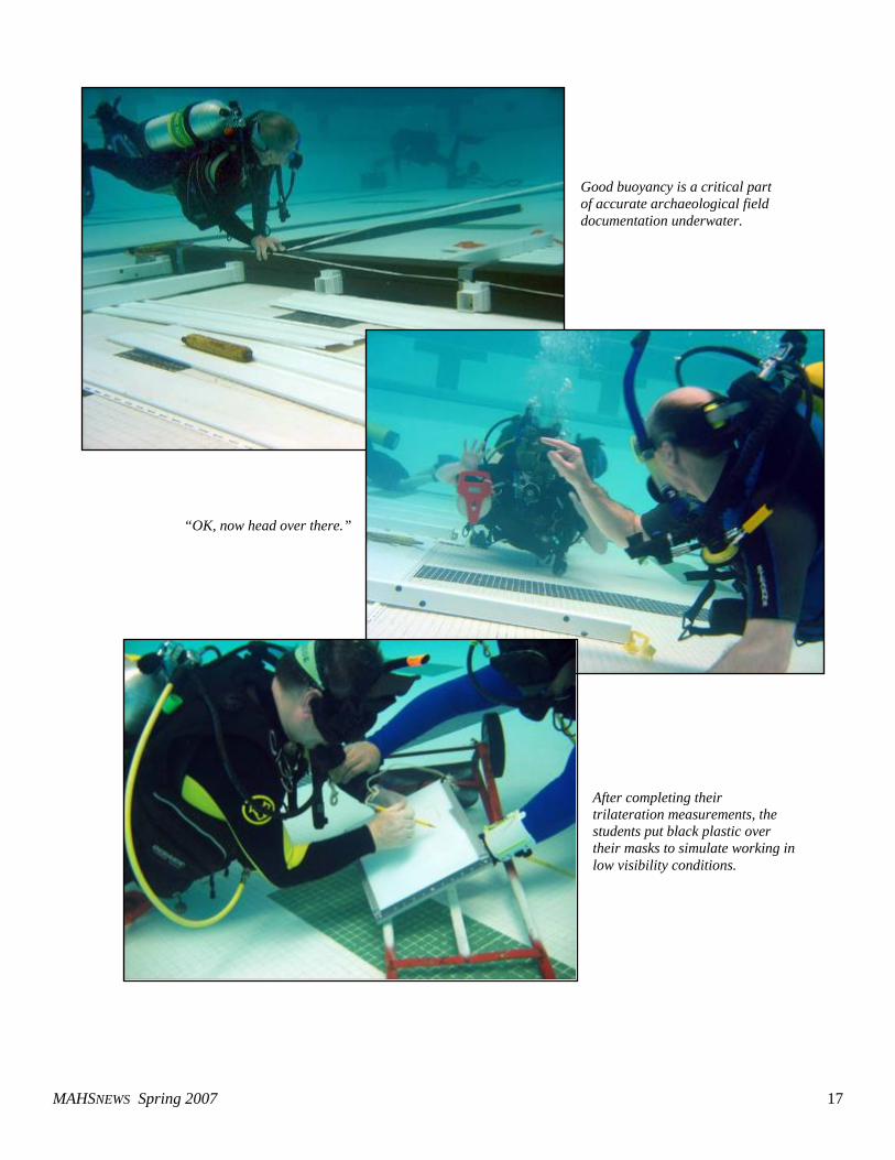
MAHS Underwater Archaeology Class Pool Session 2007
he 2007 pool session was held once again at the George Mason University Natatorium. There was a
large turn-out this year, with 20 students and nine MAHS trainers.
While the class participants shook out their gear and got their forms in order, several MAHS volunteers assembled the mock shipwreck, Lil’ Sinkenteen, and a debris field on the bottom of the pool. The students were then taken through a dry-land trilateration exercise to practice the techniques of mapping they had learned in the classroom.
The class then split into buddy teams, were
assigned areas of the mock wreck site to map, did buddy checks, and conducted their dives under the watchful eyes of MAHS instructors.
Photos by T. Berkey, M. Little, and S. Hunia. Î
T
Buddy teams practice to get it right on the side of the pool, because you can’t talk about it once you’re underwater.
Happy divers – ready to begin their mapping exercise.
Benches, chairs, tables – we map anything.
MAHSNEWS Spring 2007 17
Good buoyancy is a critical part of accurate archaeological field documentation underwater.
“OK, now head over there.”
After completing their trilateration measurements, the students put black plastic over their masks to simulate working in low visibility conditions.
MAHSNEWS Spring 2007 18
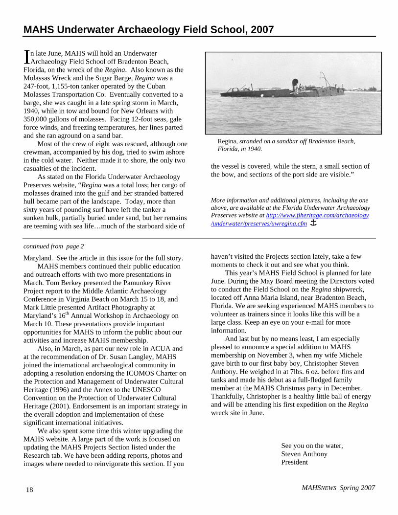
MAHS Underwater Archaeology Field School, 2007
n late June, MAHS will hold an Underwater Archaeology Field School off Bradenton Beach,
Florida, on the wreck of the Regina. Also known as the Molassas Wreck and the Sugar Barge, Regina was a 247-foot, 1,155-ton tanker operated by the Cuban Molasses Transportation Co. Eventually converted to a barge, she was caught in a late spring storm in March, 1940, while in tow and bound for New Orleans with 350,000 gallons of molasses. Facing 12-foot seas, gale force winds, and freezing temperatures, her lines parted and she ran aground on a sand bar.
Most of the crew of eight was rescued, although one crewman, accompanied by his dog, tried to swim ashore in the cold water. Neither made it to shore, the only two casualties of the incident.
As stated on the Florida Underwater Archaeology Preserves website, “Regina was a total loss; her cargo of molasses drained into the gulf and her stranded battered hull became part of the landscape. Today, more than sixty years of pounding surf have left the tanker a sunken hulk, partially buried under sand, but her remains are teeming with sea life…much of the starboard side of
the vessel is covered, while the stern, a small section of the bow, and sections of the port side are visible.”
More information and additional pictures, including the one above, are available at the Florida Underwater Archaeology Preserves website at http://www.flheritage.com/archaeology /underwater/preserves/uwregina.cfm Î
continued from page 2
Maryland. See the article in this issue for the full story. MAHS members continued their public education
and outreach efforts with two more presentations in March. Tom Berkey presented the Pamunkey River Project report to the Middle Atlantic Archaeology Conference in Virginia Beach on March 15 to 18, and Mark Little presented Artifact Photography at Maryland’s 16th Annual Workshop in Archaeology on March 10. These presentations provide important opportunities for MAHS to inform the public about our activities and increase MAHS membership.
Also, in March, as part our new role in ACUA and at the recommendation of Dr. Susan Langley, MAHS joined the international archaeological community in adopting a resolution endorsing the ICOMOS Charter on the Protection and Management of Underwater Cultural Heritage (1996) and the Annex to the UNESCO Convention on the Protection of Underwater Cultural Heritage (2001). Endorsement is an important strategy in the overall adoption and implementation of these significant international initiatives.
We also spent some time this winter upgrading the MAHS website. A large part of the work is focused on updating the MAHS Projects Section listed under the Research tab. We have been adding reports, photos and images where needed to reinvigorate this section. If you
haven’t visited the Projects section lately, take a few moments to check it out and see what you think.
This year’s MAHS Field School is planned for late June. During the May Board meeting the Directors voted to conduct the Field School on the Regina shipwreck, located off Anna Maria Island, near Bradenton Beach, Florida. We are seeking experienced MAHS members to volunteer as trainers since it looks like this will be a large class. Keep an eye on your e-mail for more information.
And last but by no means least, I am especially pleased to announce a special addition to MAHS membership on November 3, when my wife Michele gave birth to our first baby boy, Christopher Steven Anthony. He weighed in at 7lbs. 6 oz. before fins and tanks and made his debut as a full-fledged family member at the MAHS Christmas party in December. Thankfully, Christopher is a healthy little ball of energy and will be attending his first expedition on the Regina wreck site in June.
See you on the water, Steven Anthony President
I
Regina, stranded on a sandbar off Bradenton Beach, Florida, in 1940.
MAHSNEWS Spring 2007 19
MAHSNEWS Spring 2007 20