Embed Size (px)
Citation preview
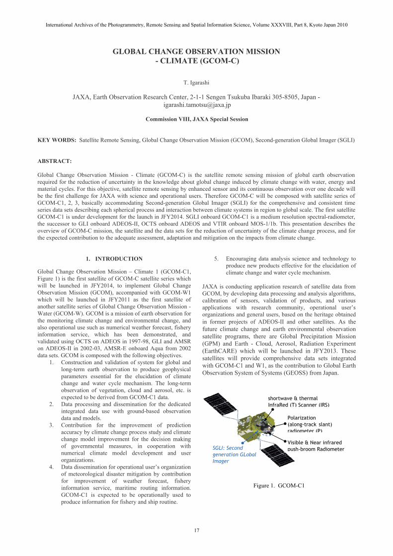
shortwave & thermal InfraRed (T) Scanner (IRS)
Figure 1. GCOM-C1
Visible & Near infrared push-broom Radiometer
Polarization(along-track slant)radiometer (P)
SGLI: Second generation GLobal Imager
GLOBAL CHANGE OBSERVATION MISSION - CLIMATE (GCOM-C)
T. Igarashi
JAXA, Earth Observation Research Center, 2-1-1 Sengen Tsukuba Ibaraki 305-8505, Japan - [email protected]
Commission VIII, JAXA Special Session
KEY WORDS: Satellite Remote Sensing, Global Change Observation Mission (GCOM), Second-generation Global Imager (SGLI)
ABSTRACT:
Global Change Observation Mission - Climate (GCOM-C) is the satellite remote sensing mission of global earth observation required for the reduction of uncertainty in the knowledge about global change induced by climate change with water, energy andmaterial cycles. For this objective, satellite remote sensing by enhanced sensor and its continuous observation over one decade will be the first challenge for JAXA with science and operational users. Therefore GCOM-C will be composed with satellite series of GCOM-C1, 2, 3, basically accommodating Second-generation Global Imager (SGLI) for the comprehensive and consistent time series data sets describing each spherical process and interaction between climate systems in region to global scale. The first satellite GCOM-C1 is under development for the launch in JFY2014. SGLI onboard GCOM-C1 is a medium resolution spectral-radiometer, the successor to GLI onboard ADEOS-II, OCTS onboard ADEOS and VTIR onboard MOS-1/1b. This presentation describes the overview of GCOM-C mission, the satellite and the data sets for the reduction of uncertainty of the climate change process, and for the expected contribution to the adequate assessment, adaptation and mitigation on the impacts from climate change.
1. INTRODUCTION
Global Change Observation Mission – Climate 1 (GCOM-C1, Figure 1) is the first satellite of GCOM-C satellite series which will be launched in JFY2014, to implement Global Change Observation Mission (GCOM), accompanied with GCOM-W1 which will be launched in JFY2011 as the first satellite of another satellite series of Global Change Observation Mission - Water (GCOM-W). GCOM is a mission of earth observation for the monitoring climate change and environmental change, and also operational use such as numerical weather forecast, fishery information service, which has been demonstrated, and validated using OCTS on ADEOS in 1997-98, GLI and AMSR on ADEOS-II in 2002-03, AMSR-E onboard Aqua from 2002 data sets. GCOM is composed with the following objectives.
1. Construction and validation of system for global and long-term earth observation to produce geophysical parameters essential for the elucidation of climate change and water cycle mechanism. The long-term observation of vegetation, cloud and aerosol, etc. is expected to be derived from GCOM-C1 data.
2. Data processing and dissemination for the dedicated integrated data use with ground-based observation data and models.
3. Contribution for the improvement of prediction accuracy by climate change process study and climate change model improvement for the decision making of governmental measures, in cooperation with numerical climate model development and user organizations.
4. Data dissemination for operational user’s organization of meteorological disaster mitigation by contribution for improvement of weather forecast, fishery information service, maritime routing information. GCOM-C1 is expected to be operationally used to produce information for fishery and ship routine.
5. Encouraging data analysis science and technology to produce new products effective for the elucidation of climate change and water cycle mechanism.
JAXA is conducting application research of satellite data from GCOM, by developing data processing and analysis algorithms, calibration of sensors, validation of products, and various applications with research community, operational user’s organizations and general users, based on the heritage obtained in former projects of ADEOS-II and other satellites. As the future climate change and earth environmental observation satellite programs, there are Global Precipitation Mission (GPM) and Earth - Cloud, Aerosol, Radiation Experiment (EarthCARE) which will be launched in JFY2013. These satellites will provide comprehensive data sets integrated with GCOM-C1 and W1, as the contribution to Global Earth Observation System of Systems (GEOSS) from Japan.
International Archives of the Photogrammetry, Remote Sensing and Spatial Information Science, Volume XXXVIII, Part 8, Kyoto Japan 2010
17
OrbitSun-synchronous (descending local time: 10:30)Altitude: 798km, Inclination: 98.6deg
Launch Date JFY2014 (HII-A) Mission Life 5 years (3 satellites; total 13 years)
Scan Push-broom electric scan (VNR: VN & P) Wisk-broom mechanical scan (IRS: SW & T)
Scan width 1150km cross track (VNR: VN & P) 1400km cross track (IRS: SW & T)
Digitalization 12bitPolarization 3 polarization angles for P Along track direction
Nadir for VN, SW and T,+45 deg and -45 deg for P
On-boardcalibration
VN: Solar diffuser, Internal lamp (PD), Lunarby pitch maneuvers, and dark current by masked pixels and nighttime observation SW: Solar diffuser, Internal lamp, Lunar, and dark current by deep space window T: Black body and dark current by deep spacewindowAll: Electric calibration
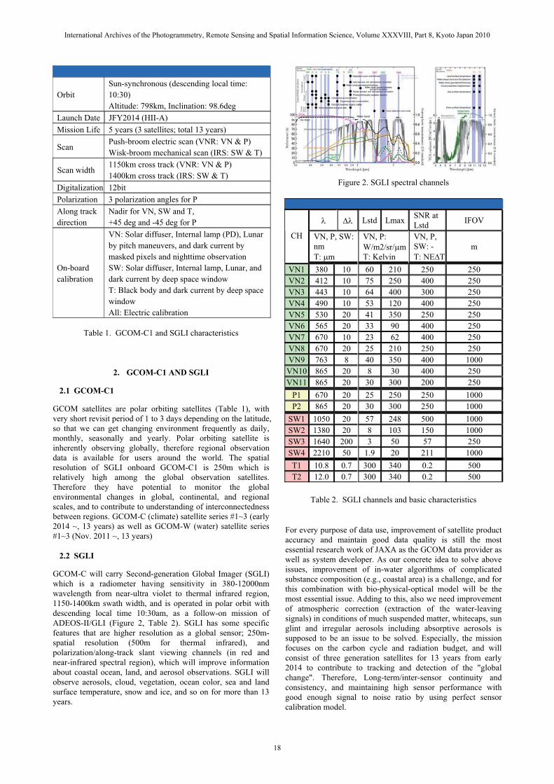
Figure 2. SGLI spectral channels
Table 1. GCOM-C1 and SGLI characteristics
2. GCOM-C1 AND SGLI
2.1 GCOM-C1
GCOM satellites are polar orbiting satellites (Table 1), with very short revisit period of 1 to 3 days depending on the latitude, so that we can get changing environment frequently as daily, monthly, seasonally and yearly. Polar orbiting satellite is inherently observing globally, therefore regional observation data is available for users around the world. The spatial resolution of SGLI onboard GCOM-C1 is 250m which is relatively high among the global observation satellites. Therefore they have potential to monitor the global environmental changes in global, continental, and regional scales, and to contribute to understanding of interconnectedness between regions. GCOM-C (climate) satellite series #1~3 (early 2014 ~, 13 years) as well as GCOM-W (water) satellite series #1~3 (Nov. 2011 ~, 13 years)
2.2 SGLI
� �� Lstd Lmax SNR at Lstd IFOV
CH VN, P, SW: nmT: �m
VN, P: W/m2/sr/�mT: Kelvin
VN, P, SW: - T: NE�T
m
VN1 380 10 60 210 250 250VN2 412 10 75 250 400 250VN3 443 10 64 400 300 250VN4 490 10 53 120 400 250VN5 530 20 41 350 250 250VN6 565 20 33 90 400 250VN7 670 10 23 62 400 250VN8 670 20 25 210 250 250VN9 763 8 40 350 400 1000
VN10 865 20 8 30 400 250VN11 865 20 30 300 200 250
P1 670 20 25 250 250 1000P2 865 20 30 300 250 1000
SW1 1050 20 57 248 500 1000SW2 1380 20 8 103 150 1000SW3 1640 200 3 50 57 250SW4 2210 50 1.9 20 211 1000T1 10.8 0.7 300 340 0.2 500T2 12.0 0.7 300 340 0.2 500
Table 2. SGLI channels and basic characteristics
For every purpose of data use, improvement of satellite product accuracy and maintain good data quality is still the most essential research work of JAXA as the GCOM data provider as well as system developer. As our concrete idea to solve above issues, improvement of in-water algorithms of complicated substance composition (e.g., coastal area) is a challenge, and for this combination with bio-physical-optical model will be the most essential issue. Adding to this, also we need improvementof atmospheric correction (extraction of the water-leaving signals) in conditions of much suspended matter, whitecaps, sun glint and irregular aerosols including absorptive aerosols is supposed to be an issue to be solved. Especially, the mission focuses on the carbon cycle and radiation budget, and will consist of three generation satellites for 13 years from early 2014 to contribute to tracking and detection of the "global change". Therefore, Long-term/inter-sensor continuity and consistency, and maintaining high sensor performance with good enough signal to noise ratio by using perfect sensor calibration model.
GCOM-C will carry Second-generation Global Imager (SGLI) which is a radiometer having sensitivity in 380-12000nm wavelength from near-ultra violet to thermal infrared region, 1150-1400km swath width, and is operated in polar orbit with descending local time 10:30am, as a follow-on mission of ADEOS-II/GLI (Figure 2, Table 2). SGLI has some specific features that are higher resolution as a global sensor; 250m-spatial resolution (500m for thermal infrared), and polarization/along-track slant viewing channels (in red and near-infrared spectral region), which will improve information about coastal ocean, land, and aerosol observations. SGLI will observe aerosols, cloud, vegetation, ocean color, sea and land surface temperature, snow and ice, and so on for more than 13 years.
International Archives of the Photogrammetry, Remote Sensing and Spatial Information Science, Volume XXXVIII, Part 8, Kyoto Japan 2010
18
3. MISSION CONCEPT
3.1 Mission Goal
GCOM will be maintained toward the final mission goal which should be accomplished by the end of 13 year observation, processing and analysis and application research period, as the followings.
1. The establishment of long-term observation system for the global carbon cycle and radiation budget, integrated with other earth observation systems.
2. Contribution to numerical climate models (driving force, outputs comparison, and parameter tuning).
3. Contribution to operational use (weather forecast, monitoring of meteorological disaster, fishery..).
4. Enhancement of new satellite data usability.
3.2 Cloud and Aerosol Roles in the Radiation Budget
In recent years, the global warming is emerging as the social common concern worldwide as well as science and technology challenges. For the understanding of future trend prediction of the climate change, the most significant factor of global warming is the atmospheric CO2 concentration, as discussed in the IPCC report. However, the most significant uncertainty ofradiative forcing is direct/indirect role of cloud-aerosol system. Therefore, monitoring and process investigation about cloud and aerosol by GCOM-C & EarthCARE is proposed to be explored (Figure 3).
Figure 3. Observation by GCOM-C and EarthCARE to retrieve cloud and aerosol in horizontal and vertical distribution
3.3 Carbon Budget at Present and Future
The expected contribution by GCOM-C is process investigation and long-term diagnosis with model for the carbon budget. At present, carbon flux is estimated as shown in Figure 4, and parameters in Figure 5 are necessary for the future.
Figure 4 Expected contributions by GCOM-C to reduce uncertainty in the carbon budget estimation at present
Figure 5 Expected contributions by GCOM-C to reduce uncertainty in the carbon budget estimation in the future
TTooddaayy’’ss CCaarrbboonn bbuuddggeettAtmosphere CO2 +3.2
Net of Land -1.0
Modified from the 4th IPCC report
Monitoring of primary production
increas
Contribution by GCOM-C
Primary production estimation (ADEOS-II/GLI) Left: land primary production in 2003 (Muramatsu,
FFuuttuurree CCaarrbboonn ccyyccllee
Several tens of % uncertainty in the global warming
Global environmental change(irradiance, temperature, CO2,
FEEDBACk
Change of atmosphere CO2
Change of ecosystem capacity of CO2 sink and
LLaanndd OOcceeaann•Photosynthesis
production
- Vegetation index
- Leaf area index
- Primary production
- Above-ground biomass
•Land cover/use
•Soil respiration
•Photosynthesis production
- Phytoplankton chlorophyll-a
- Sea surface temperature
- PAR
- Dissolved organic matter
•CO2 solution, pH
•Sedimentation
CO2 increaseand
Global warming
EarthCARE/CPR3D structure of cloud and aerosol
Aerosol
et al., 2009)GCOM-CGlobal/horizontal distribution of cloud and aerosol
Right: ocean primary productivity, in Apr.-Jun. 2003
radiative forcing change
Cloud
International Archives of the Photogrammetry, Remote Sensing and Spatial Information Science, Volume XXXVIII, Part 8, Kyoto Japan 2010
19
4. GCOM-C PRODUCTS
4.1 Aerosol
Land aerosol by Near-UV and polarization will produce more valuable information as shown in Figure 6, 7.
1. Not only over the ocean, SGLI will estimate land-area aerosols using near-UV (380nm) and polarization channels which are more sensitive to the atmospheric scattering rather than the land surface reflection.
2. Combination of aerosol absorption by Near-UV and fine-mode aerosol properties by polarization.
Figure 6. Global aerosol optical thickness in June 2003 using the GLI Near-UV (380nm) channel (NIR for the ocean area)
Figure 7. Global aerosol optical thickness in June 2003 using POLDER-2 polarization reflectance
4.2 Ocean
4.3 Land
SGLI has directional observation function for the land coverclassification and the biomass estimation (Figure 9, 10). Reflectance changes depending on the observation angles.
1. By using reflectance change of slant and nadir observations, vertical structure of trees can be estimated (e.g., difference between a paddy field and a forest).
2. The information is useful for land cover classification and above-ground biomass estimation.
Tree height = 1m Tree height = 5m
CanopyObservation angle
SGLI VNR, 250m resolution image will enable to detect more fine structures in the coastal area such as river outflows, regional blooms, and small currents (Figure 8).
Figure 8. 250m Ocean color chlorophyll-a and NDVI simulated using GLI 250m channels
Figure 9. 250m Ocean color chlorophyll-a and NDVI simulated using GLI 250m channels
Figure 10. SGLI directional observation
4.4 Cryosphere
Snow property in large scale area changes in the global warming. In this process, ice-albedo feedback is one of the feedback processes to accelerate global warming, especially in the early phase, and snow grain size can be an early indicator of the global warming (Figure 11, 12).
Observation angle= - 60 deg.
= 0 deg.
Soil
Same green area Increase green area
0 deg + 45 deg Forwardscattering
� 45 deg Backwardscattering
Tree height
diameter at breast height
Provided by Honda Lab. Chiba Univ.Vegetation model (Arboreal vegetation)
(a) GLI 1km Osaka Bay (b) GLI 250m Osaka Bay (1 Oct. 2003, CHL by LCI) (1 Oct. 2003, CHL by LCI)
International Archives of the Photogrammetry, Remote Sensing and Spatial Information Science, Volume XXXVIII, Part 8, Kyoto Japan 2010
20
Figure 11. Conceptual image of ice albedo feedback
Figure 12. Snow grain sizes in shallow layer retrieved from GLI data in April, 2003
5. APPLICATIONS
Long-term observation can provide time series trend data sets and they can be compared year to year to find anomaly. Figure 13 shows Normalized Difference Vegetation Index (NDVI) average value in the area enclosed with a black line in the Eastern Australia grain zone in Figure 13, 14.
1. Time series of NDVI shows vegetation damage by drought in 2002 and 2006, when the wheat crop yields was reduced by about half in those years.
2. GCOM long-term observation will be effective to detect environmental anomaly such as the drought.
Figure 13. NDVI anomaly in 2002 the 4th season (left) and in 2006 the 4th season (right)
Figure 14. Vegetation index in the Eastern Australia grain zone for every season using SeaWiFS product (Circles show
anomalies)
6. INTERNATIONAL COOPERATION
Global earth observation satellites and polar orbiting meteorological satellites are complementally used by both environmental and meteorological users. As shown in Table 3, visible/infrared imagers are planned to be operated by European METOP A-D and Aentinel-3A, 3B in morning orbit and NPP and JPSS series in afternoon orbit will be useful for the improvement of observation frequency to sample diurnal variations of environment. GCOM-C with its advanced measurement function and high performance will contribute not only to the international global observation system, such as GEOSS, CEOS consternation, by using common functions, but also to the high resolution land and coastal observation, land aerosol, and biomass estimation. Especially, SGLI has 250m spatial-resolution, near-UV, multi-angle, and polarization observations suitable for areas having long coast lines, bordering on rapidly developing industrial areas like Japan. Comparison of characteristics, function and performances of major global optical sensors; GCOM-C/SGLI, NPP, JPSS/VIIRS, MODIS, Sentinel/OLCI, SLST, MERIS+AATSR are summarized in Table 4.
10:30/
09:30
13:30
05 06 07 08 09 11 12 13 14 15 16 17 18 19 20 21 22 23 24 2510
SSM/ISSSM/IS
AVHRR
AVHRR/3 MIS
AMSR-E
MODIS
J
U
E
J
U
E
AVHRR/3
DMSP-F16 DMSP-F18
Aqua
Aqua
NOAA-N NOAA-N’
NOAA-M
AVHRR/3 AVHRR/3 AVHRR/3 AVHRR/3+
METOP A METOP B METOP C METOP D
SGLI SGLI SGLI
GCOM-C1 GCOM-C2 GCOM-C3
AMSR2 AMSR2 AMSR2
GCOM-W1 GCOM-W2 GCOM-W3
Passive Microwave Radiometer Visible/Infrared Imager
LTAN/LTDN
OLCI, SLSTSentinel-3A Sentinel-3B
VIIRS VIIRS VIIRSNPP
JPSS
MODIS
Terra
Sensor Sensor
Sensor SensorPre- JPSS/METOP/GCOM
Aft- JPSS/METOP/GCOM
Pre- JPSS/METOP/GCOM
Aft- JPSS/METOP/GCOM
10:30/
09:30
13:30
05 06 07 08 09 11 12 13 14 15 16 17 18 19 20 21 22 23 24 2510
SSM/ISSSM/IS
AVHRR
AVHRR/3 MIS
AMSR-E
MODIS
J
U
E
J
U
E
AVHRR/3
DMSP-F16 DMSP-F18
Aqua
Aqua
NOAA-N NOAA-N’
NOAA-M
AVHRR/3 AVHRR/3 AVHRR/3 AVHRR/3+
METOP A METOP B METOP C METOP DAVHRR/3 AVHRR/3 AVHRR/3 AVHRR/3+
METOP A METOP B METOP C METOP D
SGLI SGLI SGLI
GCOM-C1 GCOM-C2 GCOM-C3SGLI SGLI SGLI
GCOM-C1 GCOM-C2 GCOM-C3
AMSR2 AMSR2 AMSR2
GCOM-W1 GCOM-W2 GCOM-W3AMSR2 AMSR2 AMSR2
GCOM-W1 GCOM-W2 GCOM-W3
Passive Microwave Radiometer Visible/Infrared Imager
LTAN/LTDN
OLCI, SLSTSentinel-3A Sentinel-3B
OLCI, SLSTSentinel-3A Sentinel-3B
VIIRS VIIRS VIIRSNPP
JPSS
VIIRS VIIRS VIIRSNPP
JPSS
MODIS
Terra
Sensor Sensor
Sensor SensorPre- JPSS/METOP/GCOM
Aft- JPSS/METOP/GCOM
Pre- JPSS/METOP/GCOM
Aft- JPSS/METOP/GCOM
Table 3. Cooperation with operational satellites
Snow grain size
increase
Snow albedodecrease
Snow surface Temperature
increase
Snow/ice areadecreasemelting
Solar irradiance absorption of polar region: increase
melting
Global warming
Feedbac
Solar irradiance absorption of snow surface: increase
0.30
0.40
0.50
0.60
0.70
1997
/09/
21~1
997/
12/2
019
97/1
2/21
~199
8/03
/20
1998
/03/
21~1
998/
06/2
019
98/0
6/21
~199
8/09
/20
1998
/09/
21~1
998/
12/2
019
98/1
2/21
~199
9/03
/20
1999
/03/
21~1
999/
06/2
019
99/0
6/21
~199
9/09
/20
1999
/09/
21~1
999/
12/2
019
99/1
2/21
~200
0/03
/20
2000
/03/
21~2
000/
06/2
020
00/0
6/21
~200
0/09
/20
2000
/09/
21~2
000/
12/2
020
00/1
2/21
~200
1/03
/20
2001
/03/
21~2
001/
06/2
020
01/0
6/21
~200
1/09
/20
2001
/09/
21~2
001/
12/2
020
01/1
2/21
~200
2/03
/20
2002
/03/
21~2
002/
06/2
020
02/0
6/21
~200
2/09
/20
2002
/09/
21~2
002/
12/2
020
02/1
2/21
~200
3/03
/20
2003
/03/
21~2
003/
06/2
020
03/0
6/21
~200
3/09
/20
2003
/09/
21~2
003/
12/2
020
03/1
2/21
~200
4/03
/20
2004
/03/
21~2
004/
06/2
020
04/0
6/21
~200
4/09
/20
2004
/09/
21~2
004/
12/2
020
04/1
2/21
~200
5/03
/20
2005
/03/
21~2
005/
06/2
020
05/0
6/21
~200
5/09
/20
2005
/09/
21~2
005/
12/2
020
05/1
2/21
~200
6/03
/20
2006
/03/
21~2
006/
06/2
020
06/0
6/21
~200
6/09
/20
2006
/09/
21~2
006/
12/2
0
ND
VI
International Archives of the Photogrammetry, Remote Sensing and Spatial Information Science, Volume XXXVIII, Part 8, Kyoto Japan 2010
21

GCOM-C / SGLI
Near-UV
Visible to thermal infrared global
observation (19ch)
Polarimetry
Multi-angle obs. (2ch)
Sentinel/OLCI+SLST, MERIS+AATSR
-
-
Many multi-angle obs.(~9ch) for precise
SST/LST estimation
Wide FOV ~3000kmFOV 1150~1400km FOV~1200km
Visible to thermal infrared global
observation(22ch;MODIS:36ch
250m resolution (11ch) 370m (5ch) 300~500m resolution
-
Visible to thermal infrared global
observation(~25chby two sensors)
-
-
Thermal infrared (3ch)
Many thermal channels (7ch) for
fire/night time obs.
NPP, JPSS / VIIRS, MODIS
Thermal infrared (2ch)
ACKNOWLEDGEMENTS
I thank Haruhisa Shimoda for his chair of GCOM science advisory board of leading scientists and representatives from operational user organizations provided with a broad overview of GCOM concept that would have been difficult to achieve in any other way. I also thank Yoshiaki Honda for leading GCOM-C science team of Principal Investigators provided with an original science plan for the next generation of satellite remote sensing of the climate change. Keizo Nakagawa and Kazuhiro Tanaka provided updated GCOM project and satellite and sensor system engineering information. JMA, NOAA and EUMETSAT provided many ideas of possibility in climate applications and international cooperation which will be very useful to encourage operational use of GCOM data to the climate information services as well as meteorological services. NIES, JAMSTEC and JAXA started discussion on ecosystem and cooperation between observation and model, and CEOS ocean color consternation with space agencies is approved to progress toward the implementation. Hiroshi Murakami, Masayuki Hori, Akiko Ono provided useful discussions about the material presented here, especially on new features of remote sensing technology of GCOM-C/SGLI to implement new user requirements and improve unaccomplished measurement function and performance by ADEOS-II/GLI and other old and new similar projects.
Table 4. Comparison of global optical sensors
7. CONCLUSIONS
1. JAXA is establishing the GCOM-C satellite series, which will be launched in JFY2014 and it will encourage Japanese ocean-color, global atmosphere, land, cryosphere remote sensing again, after the blank of our own data sets since the end of GLI operation in 2003.
2. Goals of GCOM-C research are followings; - Establishment of long-term observation system for the
global carbon cycle and radiation budget.- Integrated use with other earth observation systems. - Contribution to numerical climate models (driving force,
outputs comparison, and parameter tuning). - Contribution to operational use (weather forecast,
monitoring of meteorological disaster, fishery, etc.). - Enhancement of new satellite data usability. 3. They will also contribute to the implementation plan and
the goal of GEOSS, as the Japanese initiative program.
REFERENCES
Kameda, T., Ishizaka, J., 2005. Size-Fractionated Primary Production Estimated by a Two-Phytoplankton Community Model Applicable to Ocean Color Remote Sensing, Journal of Oceanography, 61(4), pp.663-672.
Muramatsu, K., Furumi, S., Chen, L., Xiong, Y., Daigo, M., 2009. Estimating and Validating the Net Primary Production of Vegetation using ADEOS-II/GLI Global Mosaic and 250-m Spatial Resolution Data. Journal of The Remote Sensing Society of Japan, 29(1), pp. 114-123.
Nakajima, T., Murakami, H., Hori, M., Nakajima, T.Y., Yamamoto, H., Ishizaka, J., Tateishi, R., Aoki, T., Takamura, T., Kuji, M., Nguyen, D.D., Ono, A., Fukuda, S., Muramatsu, K., 2009. Overview and Science Highlights of the ADEOS-II/GLI Project. Journal of The Remote Sensing Society of Japan,29(1), pp. 11-28.
International Archives of the Photogrammetry, Remote Sensing and Spatial Information Science, Volume XXXVIII, Part 8, Kyoto Japan 2010
22