Embed Size (px)
Citation preview

Global FishinG Watch Reveals a FisheRies ManaGeMent success in the Phoenix islands
Protecting the World’s Oceans
© Global Fishing Watch

© Randi Rotjan | New England Aquarium

ocEANA.oRG | 1
Global FishinG Watch has enabled oceana to monitor the Phoenix Islands Protected area (PIPa) and document a drastic reduction in observed FishinG activity FolloWinG neW reGulations that established it as a no-take area

2 | PhoENix islANds PRotEctEd AREA PhoENix islANds PRotEctEd AREA
CONTENTS
3 Using Global Fishing Watch to Monitor the Oceans
5 What is PIPA?
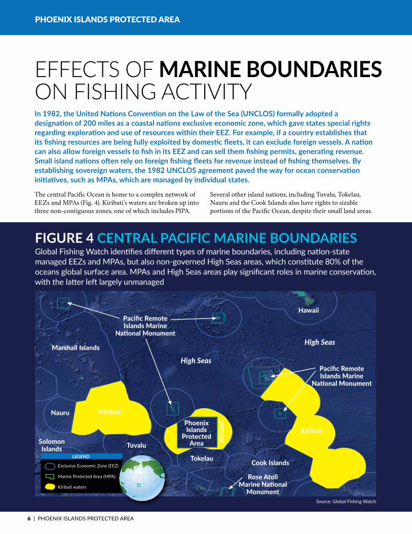
6 EffectsofMarineBoundaries onFishingActivity
9 WhatRulesGovernFishinginPIPA?
10KiribatiDeclaredFishing BannedinPIPA,Effective January1,2015
10 What Can Global Fishing WatchTellUsAboutFishingActivityinPIPA?
11 HowHasFishingActivityinKiribatiChangedin2015?
14 What is the Economic Impact oftheFishingBaninPIPA onKiribati?
15 What Can We Learn From a GlobalFishingWatchAnalysis ofPIPA?
ACkNOwlEdgEmENTSThe authors Taylor Witkin,
Adam Reyer and Jacqueline Savitz
would like to acknowledge the
following people for providing input
and advice on this report:
Bjorn Bergman, Paul Woods,
Kevin Wurster and John Amos of
SkyTruth, Brian Sullivan of Google,
and Dustin Cranor, Amelia Vorpahl
and Wessley Merten of Oceana.
© Randi Rotjan | New England Aquarium
Global FishinG Watch uses data From the automatic IdentIfIcatIon system (aIs), a trackIng system used by over 200,000 vessels around the World

ocEANA.oRG | 3
Global Fishing Watch uses data from the Automatic Identification System (AIS), a tracking system used by over 200,000 vessels around the world. Though the tracking system is primarily used for collision avoidance, Global
Fishing Watch has developed an algorithm that detects likely fishing behavior, allowing for near real-time monitoring of fishing effort worldwide. Global Fishing Watch also identifies marine boundaries like Exclusive Economic Zones
PhOENix iSlANdS PrOTECTEd ArEA
Oceana, in partnership with Google and SkyTruth, has developed Global Fishing Watch, a public, web-based technology platform that will track global fishing activity and be used to improve transparency and traceability in the world’s fishing industry. It will allow scientists to study the interactions between fishing and ocean processes, help governments better manage fish stocks and enforce policies aimed at rebuilding their fisheries, and provide citizens, NGOs and activists with the information they need to hold governments and fisheries management organizations accountable for responsible fisheries management practices. Oceana and its partners released the Global Fishing Watch prototype in late 2014, and are now developing a version for public release.
UsInGGloBAlFIsHInGWATCH tO MonitoR the oceans
FiGuRe 1 Global MaRine boundaRiesGlobal Fishing Watch provides a global view of marine boundaries, such as Exclusive Economic Zones and Marine Protected Areas.
Exclusive Economic Zone (EEZ)
Marine Protected Area (MPA)
leGend
source: Global Fishing Watch

4 | PhoENix islANds PRotEctEd AREA
(EEZs) managed by the sovereign nations, as well as Marine Protected Areas (MPAs) (Fig. 1). Maps generated by Global Fishing Watch illuminate fishing effort in relation to EEZs and MPAs (Fig. 2).
With near real-time data, as well as historical data from 2012 to the present, Global Fishing Watch illustrates the progression of fishing activity in regions of interest, such as the central Pacific Ocean, home to incredibly rich, diverse ecosystems and economically important fish species like yellowfin tuna. The patterns of fishing fleets are shaped by a myriad of factors, from shifting weather patterns and fish migration routes to changes in seafood market structures. New fisheries regulations or establishment of marine boundaries, such as MPAs increasingly employed to safeguard our oceans’ treasures, can also significantly alter fishing behavior in a given region.
However, the degree of protection that MPAs provide varies. No-take areas, which cover about 1.5 percent of the world’s oceans15, prohibit all fishing activity, while other reserves employ more dynamic management measures,
from restricting fishing during certain seasons to banning specific gear types. Research has shown that when areas are truly protected from the impacts of fishing, they not only recover, but seed surrounding areas many miles away, helping to strengthen ecosystems well outside their boundaries.1 Unfortunately, given the size of many MPAs and a lack of resources among countries that establish them, management measures within reserves often go unenforced. Many of these are known in the conservation community as “paper parks.”
One case that demonstrates how policy, monitoring and enforcement can come together to protect an important area, while preserving the economic benefits of fishing for the governing nation, is the Phoenix Islands Protected Area (PIPA), which was officially declared a no-take MPA at the start of 2015. Global Fishing Watch has enabled Oceana to monitor the reserve and document a drastic reduction in observed fishing activity following new regulations that established the area as no-take. Oceana was also able to observe illegal fishing activity in the area, an ability that could help with marine reserve enforcement in the future.
PhOENix iSlANdS PrOTECTEd ArEA
FiGuRe 2 Global FishinG eFFoRtGlobal Fishing Watch maps likely fishing activity in relation to marine boundaries, providing a free, interactive and global visualization of patterns and trends in fishing to anyone with an internet connection.
source: Global Fishing Watch
Exclusive Economic Zone (EEZ)
Marine Protected Area (MPA)
Fishing Effort
leGend

ocEANA.oRG | 5
PhOENix iSlANdS PrOTECTEd ArEA
source: PiPA Management Plan, 2009-2014
Marine Protected Area (MPA)
Exclusion Zone
Restricted Use Zone
No take Zone
leGend
McKean
Nikumaroro
orona Manra
Rawaki
Winslow Submerged Reef
Carondelet Submerged Reef
Enderbury
Birnie
Kanton
Phoenix islands Protected Area Boundary
Purse seine Exclusion Zone
PIPA, until recently, has been a multi-use marine reserve with little regulation of fishing. Declared an MPA in 2006 by the Republic of Kiribati, PIPA is one of the largest marine reserves in the world and is home to some of the most pristine coral reef habitats on the planet.
WhAt Is PiPA?
FiGuRe 3 Phoenix islands PRotected aRea Map of the Phoenix Islands Protected Area, governed by the central Pacific island nation of Kiribati.
Smack in the middle of the Pacific Ocean between Hawaii and New Zealand, PIPA is home to one of the most prized groups of fish known to man – tuna (Fig. 3). It is also home to at least eight species of sharks, more than 500 species of reef fish, 200 species of corals, and many marine mammals like bottlenose and common dolphins. The reserve also includes a large number of seamounts, submerged extinct volcanoes that attract an incredible abundance of marine life, including large pelagic fish.
The 2006 designation of PIPA as a restricted use marine reserve limited fishing, but did not prohibit it. Given it’s multi-use, fishing continued in PIPA after regulations were adopted to govern the area in 2008. Under the original management plan, in effect from 2009 through 2014, only 12 percent of PIPA’s entire 408,250 square kilometers area was placed off limits to commercial fishing.
6 | PhoENix islANds PRotEctEd AREA
PhOENix iSlANdS PrOTECTEd ArEA
The central Pacific Ocean is home to a complex network of EEZs and MPAs (Fig. 4). Kiribati’s waters are broken up into three non-contiguous zones, one of which includes PIPA.
Several other island nations, including Tuvalu, Tokelau, Nauru and the Cook Islands also have rights to sizable portions of the Pacific Ocean, despite their small land areas.
In 1982, the United Nations Convention on the Law of the Sea (UNCLOS) formally adopted a designation of 200 miles as a coastal nations exclusive economic zone, which gave states special rights regarding exploration and use of resources within their EEZ. For example, if a country establishes that its fishing resources are being fully exploited by domestic fleets, it can exclude foreign vessels. A nation can also allow foreign vessels to fish in its EEZ and can sell them fishing permits, generating revenue. Small island nations often rely on foreign fishing fleets for revenue instead of fishing themselves. By establishing sovereign waters, the 1982 UNCLOS agreement paved the way for ocean conservation initiatives, such as MPAs, which are managed by individual states.
EFFECts OF MaRine boundaRies On FIshInG ACtIvIty
source: Global Fishing Watch
Exclusive Economic Zone (EEZ)
Marine Protected Area (MPA)
Kiribati waters
leGend
Nauru
Cook Islands
Rose Atoll Marine National
Monument
HawaiiPacific Remote Islands Marine
National MonumentHigh Seas
High Seas
Tokelau
TuvaluSolomon Islands
Marshall Islands
Phoenix Islands
Protected Area
Kiribati
Pacific Remote Islands Marine
National Monument
Kiribati
Kirib
ati
FiGuRe 4 centRal PaciFic MaRine boundaRiesGlobal Fishing Watch identifies different types of marine boundaries, including nation-state managed EEZs and MPAs, but also non-governed High Seas areas, which constitute 80% of the oceans global surface area. MPAs and High Seas areas play significant roles in marine conservation, with the latter left largely unmanaged
ocEANA.oRG | 7
PhOENix iSlANdS PrOTECTEd ArEA
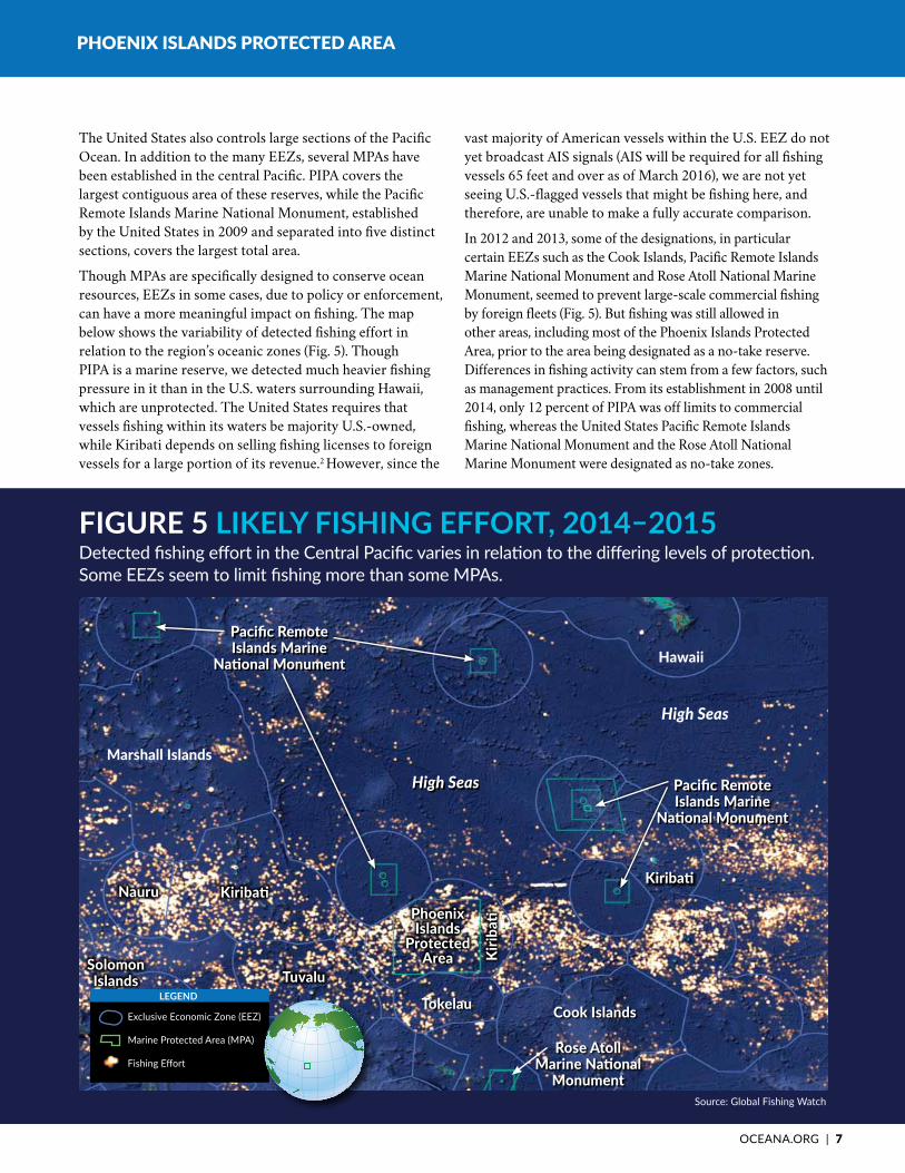
The United States also controls large sections of the Pacific Ocean. In addition to the many EEZs, several MPAs have been established in the central Pacific. PIPA covers the largest contiguous area of these reserves, while the Pacific Remote Islands Marine National Monument, established by the United States in 2009 and separated into five distinct sections, covers the largest total area.
Though MPAs are specifically designed to conserve ocean resources, EEZs in some cases, due to policy or enforcement, can have a more meaningful impact on fishing. The map below shows the variability of detected fishing effort in relation to the region’s oceanic zones (Fig. 5). Though PIPA is a marine reserve, we detected much heavier fishing pressure in it than in the U.S. waters surrounding Hawaii, which are unprotected. The United States requires that vessels fishing within its waters be majority U.S.-owned, while Kiribati depends on selling fishing licenses to foreign vessels for a large portion of its revenue.2 However, since the
vast majority of American vessels within the U.S. EEZ do not yet broadcast AIS signals (AIS will be required for all fishing vessels 65 feet and over as of March 2016), we are not yet seeing U.S.-flagged vessels that might be fishing here, and therefore, are unable to make a fully accurate comparison.
In 2012 and 2013, some of the designations, in particular certain EEZs such as the Cook Islands, Pacific Remote Islands Marine National Monument and Rose Atoll National Marine Monument, seemed to prevent large-scale commercial fishing by foreign fleets (Fig. 5). But fishing was still allowed in other areas, including most of the Phoenix Islands Protected Area, prior to the area being designated as a no-take reserve. Differences in fishing activity can stem from a few factors, such as management practices. From its establishment in 2008 until 2014, only 12 percent of PIPA was off limits to commercial fishing, whereas the United States Pacific Remote Islands Marine National Monument and the Rose Atoll National Marine Monument were designated as no-take zones.
FiGuRe 5 LIKELy FIShING EFFORT, 2014–2015Detected fishing effort in the Central Pacific varies in relation to the differing levels of protection. Some EEZs seem to limit fishing more than some MPAs.
source: Global Fishing Watch
Cook Islands
Rose Atoll Marine National
Monument
Hawaii
High Seas
Tokelau
TuvaluSolomon Islands
Marshall Islands
Exclusive Economic Zone (EEZ)
Marine Protected Area (MPA)
Fishing Effort
leGend
Kirib
ati
KiribatiKiribati
Pacific Remote Islands Marine
National Monument
Pacific Remote Islands Marine
National Monument
High Seas
NauruPhoenix Islands
Protected Area
8 | PhoENix islANds PRotEctEd AREA
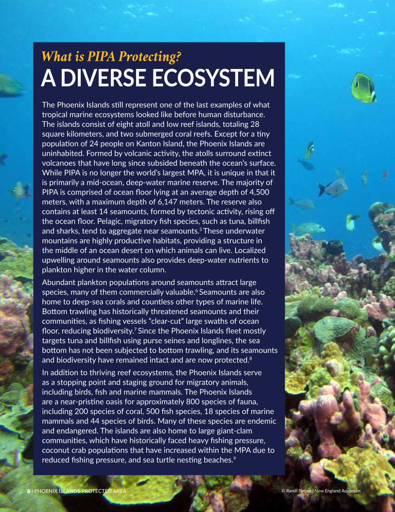
The Phoenix Islands still represent one of the last examples of what tropical marine ecosystems looked like before human disturbance. The islands consist of eight atoll and low reef islands, totaling 28 square kilometers, and two submerged coral reefs. Except for a tiny population of 24 people on Kanton Island, the Phoenix Islands are uninhabited. Formed by volcanic activity, the atolls surround extinct volcanoes that have long since subsided beneath the ocean’s surface. While PiPA is no longer the world’s largest MPA, it is unique in that it is primarily a mid-ocean, deep-water marine reserve. the majority of PIPA is comprised of ocean floor lying at an average depth of 4,500 meters, with a maximum depth of 6,147 meters. the reserve also contains at least 14 seamounts, formed by tectonic activity, rising off the ocean floor. Pelagic, migratory fish species, such as tuna, billfish and sharks, tend to aggregate near seamounts.5 these underwater mountains are highly productive habitats, providing a structure in the middle of an ocean desert on which animals can live. Localized upwelling around seamounts also provides deep-water nutrients to plankton higher in the water column. Abundant plankton populations around seamounts attract large species, many of them commercially valuable.6 seamounts are also home to deep-sea corals and countless other types of marine life. Bottom trawling has historically threatened seamounts and their communities, as fishing vessels “clear-cut” large swaths of ocean floor, reducing biodiversity.7 Since the Phoenix Islands fleet mostly targets tuna and billfish using purse seines and longlines, the sea bottom has not been subjected to bottom trawling, and its seamounts and biodiversity have remained intact and are now protected.8
In addition to thriving reef ecosystems, the Phoenix Islands serve as a stopping point and staging ground for migratory animals, including birds, fish and marine mammals. The Phoenix Islands are a near-pristine oasis for approximately 800 species of fauna, including 200 species of coral, 500 fish species, 18 species of marine mammals and 44 species of birds. Many of these species are endemic and endangered. the islands are also home to large giant-clam communities, which have historically faced heavy fishing pressure, coconut crab populations that have increased within the MPA due to reduced fishing pressure, and sea turtle nesting beaches.9
What is PIPA Protecting?
A DIvERSE ECOSySTEM
8 | PhoENix islANds PRotEctEd AREA © Randi Rotjan | New England Aquarium

ocEANA.oRG | 9
PhOENix iSlANdS PrOTECTEd ArEA
PiPA FiShiNg rESTriCTiONS, 2009 TO 2014 Kiribati announced the establishment of PIPA in 2006, and regulations were formally adopted in 2008. The original management plan was in place from 2009 until 2014. Fishing restrictions were broken into four distinct zones:
• No-take zones that banned all extractive activities and extend 12 nautical miles from each island except Kanton.
• A restricted-use zone that allowed sustainable and subsistence use of resources for the purpose of maintaining or enhancing management of the MPA.
• A fisheries-exclusion zone, where purse seiners were prohibited but longliners were allowed to fish, forming a belt around Kanton Island from 12-60 nautical miles off its shore.
• An ocean-buffer zone which comprised the rest of PIPA. In this area, fishing activities by distant water fishing nations (DWFN) were allowed with proper licenses and permits.3
ENFOrCEmENTWith so much area to cover, enforcing PIPA’s regulations would be challenging for any nation. The PIPA management plan lays out a surveillance program developed by the Kiribati Ministry of Fisheries and Maritime Police for the entire Kiribati EEZ, including PIPA. Provisions include:
• A Vessel Monitoring System (VMS), which all licensed boats must carry to identify vessel and location in real-time.
• A fisheries observer scheme, which would require all DWFN vessels to carry trained Kiribati Fisheries Observers.
• Aerial surveillance provided by New Zealand and Australia Air Forces with regular and special surveillance operations run by the Pacific Islands Forum Fisheries Agency.*
• The operation of a Kiribati patrol boat, to be called out when assistance is required (e.g. when there is an unauthorized vessel in Kiribati waters).
• The U.S. – Kiribati Ship Riders Agreement (2008), whereby Kiribati maritime and fisheries officers are able to travel on U.S. Coast Guard ships and have the power to arrest vessels under Kiribati law. This initiative has already proven successful with the impoundment and prosecution of a vessel caught illegally bunkering off Nikumaroro Atoll in PIPA ($4.7 AUD million fine).3
*The Pacific Islands Forum Fisheries Agency is comprised of 17 Pacific Island members and was established to help countries sustainably manage the fishery resources that fall within their 200 nautical mile EEZs.
The term Marine Protected Area covers a broad range of ocean protection strategies. Restrictions for the purpose of marine resource conservation and protection range from seasonal closures to fishing bans. The history of protection in PIPA has included a variety of approaches.
WhAt Rules GOvErn FIshInG In PIPA?
from 2008 – 2014, only 12 Percent of PiPa Was oFF limits to commercial FishinG
© Michael Brys

10 | PhoENix islANds PRotEctEd AREA
PhOENix iSlANdS PrOTECTEd ArEA
Through this analysis we can observe the following:
• Fishing was commonplace in PIPA in 2012, 2013 and 2014.
• From 2012 to 2014, the majority of vessels we detected fishing in PIPA were South Korean, followed by Kiribati, United States and Taiwan-flagged vessels.
• In 2014, South Korean vessels accounted for 73 percent of total fishing days that we detected in PIPA.
• Other vessels that were detected fishing in PIPA were from Belize, China, Ecuador, Fiji, Japan, the Marshall Islands, Micronesia, New Zealand, Nicaragua, Panama, Papua New
Guinea, Philippines, Spain, Taiwan, Tuvalu and Vanuatu.
• The fishing that we detected in PIPA continued through the end of December 2014, but for the most part ceased, as President Tong promised, in January 2015.
While our analysis focused only on the first 10 months of 2015, long-term monitoring and enforcement of PIPA will be necessary for the benefits of this fishing restriction to be realized. Global Fishing Watch will allow the public, government agencies and other organizations to continue to monitor the area to assess the degree to which the no-take designation is being enforced.
The original management plan restricted commercial fishing in only 12 percent of the reserve and required closing an additional 25 percent of PIPA’s area to all fishing activities by 2014.3 While the additional expansion did not happen by that time, Kiribati President Anote Tong announced in June 2014 that PIPA would be made completely off limits to commercial fishing by the beginning of 2015. PIPA is currently the third largest, contiguous no-take marine reserve, following the Pitcairn Islands Marine Reserve in the Indian Ocean and the Chagos Marine Reserve, both established by the United Kingdom. The newly designated U.S. Pacific Remote Islands Marine National Monument covers an even larger area than the Pitcairn Islands, though that no-take area is not contiguous.
Oceana is now monitoring PIPA using Global Fishing Watch, and this report shares the results of that analysis, detailing the change in observed fishing behavior as of January 1, 2015. Using Global Fishing Watch, we can see the patterns of the international fleet as it fishes for tuna and other species in PIPA. We have generated a visualization of the change in fishing behavior that is available from Oceana, SkyTruth and Google at www.globalfishingwatch.org.
KIRIBATIDEClAREDFishinG banned in PiPa,EFFECTIvEJAnUARy1,2015
WHATCAnGloBAlFIsHInGWATCHTEllUsABoUTFishinG ACTIvITy IN PIPA?
on June 16, 2014, kIrIbatI PresIdent anote tong announced that PIPa would become a no-take reserve startIng January 1, 2015, takIng the PercentaGe oF area oFF limits to commercial fIshIng from 12 Percent to 100 Percent

ocEANA.oRG | 11
PhOENix iSlANdS PrOTECTEd ArEA
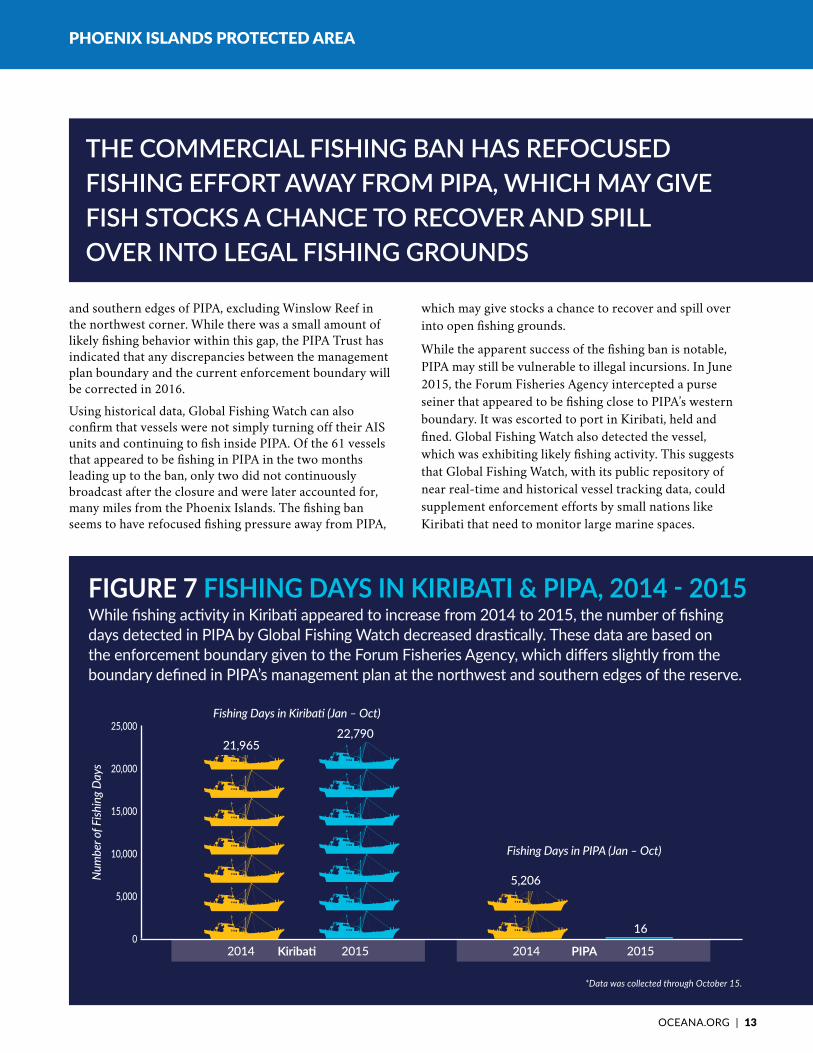
From January 1 through October 15, 2014, Global Fishing Watch detected 5,206 likely fishing days within PIPA by 155 vessels, compared to only 16 likely fishing days by 12 vessels during the same dates in 2015 (Fig. 7). This is a 99.7 percent drop in fishing activity; a resounding success. Activity by 11 of those 12 vessels is likely attributable to
drifting, while the crew was sleeping or working on gear, or the retrieval of fish aggregation devices.
This analysis is based on the enforcement boundary given to the Forum Fisheries Agency, which differs slightly from the boundary designated in the PIPA management plan. A gap was left between the two boundaries at the western
Following the designation of PIPA as a no-take marine reserve, Global Fishing Watch detected a drastic decrease in fishing activity within its boundaries. The system demonstrated that vessels that appeared to be fishing in the reserve in 2014 left PIPA and stayed away in 2015 (Fig. 6).
hOW hAs FIShING ACTIvITy In KIRIBATICHAnGEDIn2015?
FIGURE 6 beFoRe and aFteR the FishinG banHeavy fishing activity was detected by Global Fishing Watch in PIPA from January to October 2014, before the ban was enacted. Fishing activity was nearly non-existent in the first 10 months following the closure of PIPA to commercial fishing. Data was collected through October 15.*
source: Global Fishing Watch
Management Plan Boundary
Enforcement Boundary
Fishing Effort
leGend
January – October 2015January – October 2014
*The closure boundary given to the Forum Fisheries Agency does not perfectly align with the boundary mapped out in PIPA’s management plan due to shifts in EEZ delineations at the northwest edge of Kiribati’s central region. A gap exists between the two boundaries, excluding Winslow Reef in the northwest corner of the EEZ. There appears to be some continued fishing in that area. Oceana understands that Kiribati and the PIPA Trust intend to resolve this issue.

12 | PhoENix islANds PRotEctEd AREA
PIPA is home to robust shark populations compared to the rest of the world, which has seen drastic declines in some shark species. Sharks and other top predators are essential to maintaining the health of marine ecosystems.12 top-down pressure removes sick and weak fish from the ecosystem and ensures balance at each level of the food web. Reductions in predator abundance can have major impacts on the rest of the food web and can cause trophic cascades, meaning that the food web is thrown out of balance as predation on certain species decreases.13 Even in the remote Phoenix islands, however, sharks have not escaped fishing pressure. The original management plan, which established a no-take zone from the shores of PIPA’s islands out to 12 nautical miles, effectively banned shark finning in 2009, as fishermen generally captured sharks close to the shore.14 in 2012, researchers from the New England Aquarium observed a large number of juvenile sharks in the shallow waters surrounding the islands, a sign that populations could be recovering.
What is PIPA Protecting?
ShARKS
12 | PhoENix islANds PRotEctEd AREA © Randi Rotjan | New England Aquarium
ocEANA.oRG | 13
2014 2015 2014 2015
PhOENix iSlANdS PrOTECTEd ArEA
and southern edges of PIPA, excluding Winslow Reef in the northwest corner. While there was a small amount of likely fishing behavior within this gap, the PIPA Trust has indicated that any discrepancies between the management plan boundary and the current enforcement boundary will be corrected in 2016.
Using historical data, Global Fishing Watch can also confirm that vessels were not simply turning off their AIS units and continuing to fish inside PIPA. Of the 61 vessels that appeared to be fishing in PIPA in the two months leading up to the ban, only two did not continuously broadcast after the closure and were later accounted for, many miles from the Phoenix Islands. The fishing ban seems to have refocused fishing pressure away from PIPA,
which may give stocks a chance to recover and spill over into open fishing grounds.
While the apparent success of the fishing ban is notable, PIPA may still be vulnerable to illegal incursions. In June 2015, the Forum Fisheries Agency intercepted a purse seiner that appeared to be fishing close to PIPA’s western boundary. It was escorted to port in Kiribati, held and fined. Global Fishing Watch also detected the vessel, which was exhibiting likely fishing activity. This suggests that Global Fishing Watch, with its public repository of near real-time and historical vessel tracking data, could supplement enforcement efforts by small nations like Kiribati that need to monitor large marine spaces.
the commercial FishinG ban has reFocused fIshIng effort away from PIPa, whIch may gIve fIsh stocks a chance to recover and sPIll over into leGal FishinG Grounds
FiGuRe 7 FIShING DAyS IN KIRIBATI & PIPA, 2014 - 2015While fishing activity in Kiribati appeared to increase from 2014 to 2015, the number of fishing days detected in PIPA by Global Fishing Watch decreased drastically. These data are based on the enforcement boundary given to the Forum Fisheries Agency, which differs slightly from the boundary defined in PIPA’s management plan at the northwest and southern edges of the reserve.
*Data was collected through October 15.
25,000
20,000
15,000
10,000
5,000
0
Num
ber o
f Fish
ing
Day
s
Kiribati
Fishing Days in Kiribati (Jan – Oct)
PIPA
Fishing Days in PIPA (Jan – Oct)
21,965
5,206
16
22,790

14 | PhoENix islANds PRotEctEd AREA
PhOENix iSlANdS PrOTECTEd ArEA
Only a year into PIPA’s new fishing regulations, the long-term impact on revenue from licenses sold to foreign vessels is difficult to predict. As a part of the Parties to the Nauru Agreement (PNA), Kiribati uses a Vessel Day Scheme, charging a flat fee per vessel per day, with adjustment for the size of the vessel. Under the PNA, the minimum price of a vessel day increased from $6,000 in 2014 to $8,000 in 2015, in an effort to raise future revenues from licenses. The establishment of a no-take reserve in such a biologically productive area also has the potential to increase the number of fishing days in Kiribati by improving the health of existing stocks, which could spill over from PIPA into legal fishing grounds.
In fact, fishing effort detected in Kiribati by Global Fishing Watch increased from 21,965 days in 2014 ( January – October) to 22,790 fishing days in 2015 (Fig. 7). Therefore, it is unlikely that that the closure of 11.3% of Kiribati’s EEZ, represented by PIPA, negatively impacted revenue.
Since a large portion of the Republic of Kiribati’s gross domestic product (GDP) comes from selling fishing licenses to vessels from distant water fishing nations, there may be concerns about a loss of revenue once the Phoenix Islands became off limits to commercial fishing. Would vessels that had been fishing inside the protected area leave Kiribati waters altogether? The estimated revenue from fishing licenses for 2014 was $32.3 million, 27 percent of the national GDP.2
WhAt Is thE econoMic iMPact oFTHEFIsHInGBAnInPIPA onKIRIBATI?
whIle fIshIng vessels left PIPa after the ban, many continued to send ais siGnals From kIrIbatI waters and aPPeared to be fIshIng. this means that vessels Were not merely turninG oFF their ais and continuinG to fIsh In the reserve, but they were lIkely stIll buyIng fIshIng lIcenses from kIrIbatI and contributinG to its economy

ocEANA.oRG | 15
PhOENix iSlANdS PrOTECTEd ArEA
Early signs indicate progress in enforcing no-take fishing restrictions in PIPA. Although additional monitoring of the area will be needed to demonstrate more clearly whether the Kiribati government has effectively closed this area to fishing, the apparent success in PIPA suggests that: • Strong policy, such as no-take zone designation, is required to protect
biologically sensitive areas, such as MPAs, from fishing activity: Although PIPA was designated an MPA in 2006, it wasn’t until the no-take designation by the Kiribati government took effect in January 2015 that fishing in PIPA abated.
• Global Fishing Watch can be a useful monitoring tool for fishing activity in MPAs: the technology may be able to demonstrate success or failure of policies aimed at controlling fishing activity in biologically sensitive areas.
• Enforcement plays an important role in protecting marine reserves: The 17-nation Pacific Islands Forum Fisheries Agency provided enforcement in PiPA when needed. Global Fishing Watch, with its public repository of near real-time and historical vessel tracking data, could supplement enforcement efforts by small nations like Kiribati that need to monitor large marine spaces.
WhAt CAn WE LEArn FrOM AGloBAlFIsHInGWATCHANALySIS OF PIPA?
iF We emPloy this PoWerFul combination of PolIcy, monItorIng and enforcement In other exIstIng and new mPas, we should be able to Protect imPortant marine ecosystems From the ravaGes oF overFishinG and illeGal FishinG
© Randi Rotjan | New England Aquarium

16 | PhoENix islANds PRotEctEd AREA
tuna are the most economically valuable species within PiPA. the waters surrounding the Phoenix islands are home to three species: skipjack, bigeye and yellowfin tuna. Kiribati’s skipjack fishery accounts for about 70 percent of all skipjack caught in the western and central Pacific Ocean.9 skipjack are targeted primarily by purse seiners, which use Fish Aggregation Devices (FADs) to attract fish. Fishing vessels often equip FADs with radio-frequency beacons so they are easily tracked. schools of skipjack, juvenile bigeye and yellowfin tuna congregate under these devices, allowing vessels to easily remove entire shoals from the water. Bigeye tuna, which can grow up to 200 centimeters and weigh over 160 kilograms, are primarily targeted by longline vessels. Recently, however, purse seines have accounted for a slightly higher percentage of the catch. in 2013, the bigeye tuna catch for the western and central Pacific Ocean was estimated at 145,900 metric tons.8
Yellowfin tuna are similar in appearance to bigeye, and juveniles from both species can often be found together. Yellowfin have historically been targeted by purse seine vessels. In 2013, an estimated 529,400 metric tons of yellowfin tuna were removed from the ocean.8
While skipjack, bigeye and yellowfin tuna are all batch spawners, able to breed every few days once they reach sexual maturity, and are relatively resistant to fishing pressure, the increase in purse seining in the western and central Pacific Ocean has caused significant population declines.9 Fortunately, PiPA falls within known spawning grounds for bigeye and skipjack. With new management measures that will make PIPA entirely off limits to commercial fishing fleets, the Phoenix Islands may once again become a haven for tropical tuna.
What is PIPA Protecting?
tuna
16 | PhoENix islANds PRotEctEd AREA © Randi Rotjan | New England Aquarium

ocEANA.oRG | 17
1 Roberts CM, Bohnsack JA, Gell F, Hawkins JP, Goodridge R. Effects of marine reserves on adjacent fisheries. Science (80- ) 2001;294:1920–3. doi:10.1126/science.294.5548.1920.
2 International Monetary Fund. Kiribati: 2014 Article IV Consultation--Staff Report; Press Release; and Statement by the Executive Director for Kiribati. Washington, D.C.: 2014.
3 Phoenix Islands Protected Area. Phoenix Islands Protected Area Draft Management Plan 2010 - 2014. 2008.
4 NOAA Fisheries Service. Illegal Fishing: Not in Our Ports. n.d.
5 Morato T, Hoyle SD, Allain V, Nicol SJ. Seamounts are hotspots of pelagic biodiversity in the open ocean. Proc Natl Acad Sci U S A 2010;107:9707–11. doi:10.1073/pnas.0910290107.
6 Genin A. Bio-physical coupling in the formation of zooplankton and fish aggregations over abrupt topographies. J Mar Syst 2004;50:3–20. doi:10.1016/j.jmarsys.2003.10.008.
7 Pusceddu A, Bianchelli S, Martín J, Puig P, Palanques A, Masqué P, et al. Chronic and intensive bottom trawling impairs deep-sea biodiversity and ecosystem functioning. Proc Natl Acad Sci U S A 2014;111:8861–6. doi:10.1073/pnas.1405454111.
8 ISSF Tuna Stock Status Update. Status of the world fisheries for tuna. Washginton, D.C.: 2015.
9 Grande M, Murua H, Zudaire I, Korta M. Spawning activity and batch fecundity of skipjack, Katsuwonus pelamis, in the Western Indian Ocean. 2010.
10 Pala C. Kiribati commits to fishery-free reserve. Sci Insid 2014.
11 Pala C. Fishing undercuts Kiribati President’s marine protection claims. Inter Press Serv New Agency 2013. http://www.ipsnews.net/2013/06/fishing-undercuts-kiribati-presidents-marine-protection-claims/ (accessed April 9, 2015).
12 Baum JK, Worm B. Cascading top-down effects of changing oceanic predator abundances. J Anim Ecol 2009;78:699–714. doi:10.1111/j.1365-2656.2009.01531.x.
13 Worm B, Myers RA. Meta-Analysis of Cod-Shrimp Interactions Reveals Top-Down Control in Oceanic Food Webs. Ecology 2010;84:162-73
14 Mangubhai S. Phoenix Islands Blog. New Engl Aquarium 2012. http://pipa.neaq.org/2012/07/sharks-in-phoenix-islands.html (accessed March 25, 2015).
15 Lubchenco J, Crorud-Colvert K. Making Waves: The science and politics of ocean protection. Science 2015; 350:382–3. doi:10.1126/science.aad5443.
ReFeRences
“[the reserve Is] a maJor sPaWninG Ground For tuna, so Its closure Will have a major contribution to the conservation and rejuvenation oF Fish stocks and to global food securIty.”
– Anote Tong, Kiribati President
“closinG PiPa Would be the sinGle most eFFective act oF marine conservation in history and a biG steP in PreventinG the World’s last major PoPulation of skIPJack tuna from becominG as dePleted as those oF the atlantic and IndIan oceans.”
– Daniel Pauly, Oceana Board Member and fisheries scientist at the University of British Columbia in Vancouver, Canada

1350 Connecticut Ave. NW, 5th FloorWashington, dc 20036phone: +1.202.833.3900toll-free: 1.877.7.OCEANA
© Randi Rotjan | New England Aquarium
OCEANA is the largest international advocacy organization focused solely on ocean conservation. We run science-based campaigns and seek to win policy victories that can restore ocean biodiversity and ensure that the oceans are abundant and can feed hundreds of millions of people. Oceana victories have already helped to create policies that could increase fish populations in its countries by as much as 40 percent and that have protected more than 1 million square miles of ocean. We have campaign offices in the countries that control close to 40 percent of the world’s wild fish catch, including in North, South and Central America, Asia, and Europe. To learn more, please visit www.oceana.org.
Protecting the World’s Oceans
global | Washington, dc Europe | Brussels | Madrid | copenhagen North America | Boston | Ft. Lauderdale | Juneau | Monterey | New York | Portland Central America | Belize City South America | Santiago | Brazilia Asia | Manila