Embed Size (px)
Citation preview
GGOS Days + SIRGAS 2019
November 12, 2019
Rio de Janeiro, Brazil
Global Geodetic Observing System
External Relations Overview
Allison Craddock
Director, IGS Central Bureau and
Manager of External Relations, Global Geodetic Observing System (GGOS)
© 2018 California Institute of Technology. Government sponsorship acknowledged

GGOS External Relations Overview
Participation and Representation in External Stakeholder Organizations
United Nations Global Geospatial Information Management (GGIM) Subcommittee on Geodesy (SCoG)
Collaboration with UNOOSA International Committee on GNSS (ICG)
Group on Earth Observations (GEO)
Programme Board participation
Work programme review board participation for Disasters and Cross-Cutting Activities
Committee on Earth Observation Satellites (CEOS)

12/3/2019 3


…So many acronyms (GGIM Subcommittee on Geodesy and the GGRF)
UN = United Nations UN ECOSOC = Economic and Social Council
UN-GGIM = United Nations Initiative on Global Geospatial Information Management• Initiative of UN - led by United Nations Member
States • Aims to address global challenges regarding the
use of geospatial information
GGRF = Global Geodetic Reference Frame • Formulated and facilitated the Resolution
for a Global Geodetic Reference Frame for Sustainable Development (UNGGRF).
SCoG = Subcommittee on Geodesy• Recognising the growing demand for more precise
positioning services, UN-GGIM created a UN GGIM Subcommittee on Geodesy


GGOS External Relations OverviewCurrent External Relations Projects
Connecting United Nations Initiatives with the GGOS Geohazards Focus Area through the GAR19 Report
Ensures geodesy is included in globally-recognized disaster risk reduction document
Connecting the GEO Work Program (Sendai and SDGs) United Nations Initiatives with GGOS
Participation in subgroups dedicated to Sendai and SEO
Co-organizing regional workshops
Preliminary GGOS interoperable/modular elements in support of GGIM-World Bank Integrated Geospatial Information Framework
Group on Earth Observations Community Activity: “Geodesy for Sendai”
GGOS Contribution to GAR 2019
Working Group on DOIs for Geodetic Data and Products

There is tremendous potential to increase the exposure and impact of GGOS by identifying potential contributions and connecting existing relevant work to efforts in support of both UN SDGs and the Sendai Framework.
GGOS has the potential to help by:
Facilitating linkages to agencies and other providers of geodetic data
Making existing geodetic data discoverable and easily accessible
Working toward standardization
Advocating for geodetic data and infrastructure in relation to Earth observations and the Sendai Framework via the GEO Programme Board Subgroup on Sendai
Participation at the GEO Programme Board level ensures that IAG/GGOS efforts in alignment with GEO’s global priorities (supporting the UN SDGs, Sendai Framework, as well as the Paris Agreement on Climate Change) are well supported and complimentary to other related work – as well as preventing unnecessary redundancy of work.
Connecting the GEO Work Program’s United Nations Initiatives with GGOS
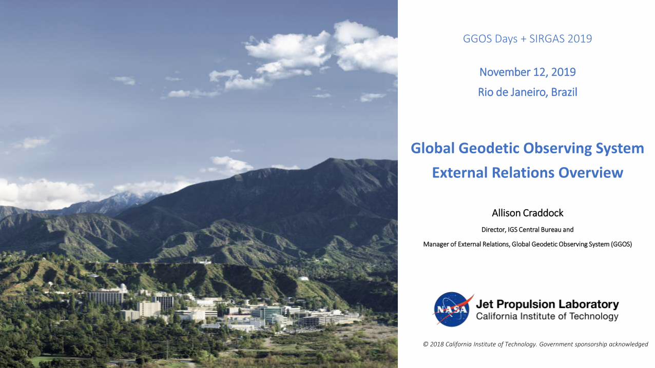
Supporting SendaiCoordinating Earth Observations for Disasters
GEO supports implementation of Sendai Framework
targets E,F and G through engagement
with UNISDR.
E: Substantially increase the number of countries with national and local disaster risk reduction strategies by 2020;
F: Substantially enhance international cooperation to developing countries through adequate and sustainable support to complement their national actions for implementation of the present framework by 2030;
G: Substantially increase the availability of and access to multi-hazard early warning systems and disaster risk information and assessments to people by 2030.
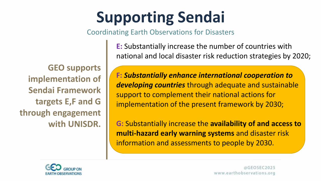
Download GTEWS report: http://bit.ly/gtews2018
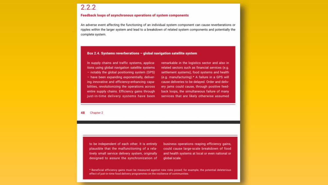
Geodetic observations have a clear role in helping to reduce the risk of disasters, as well as contribute to disaster preparedness with better mitigation and response.
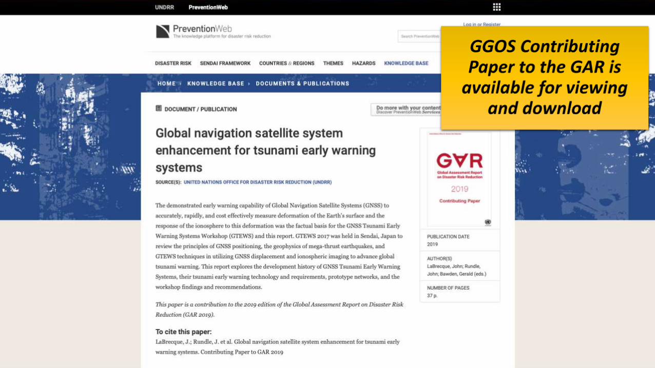
GGOS-Geohazards Working Group contributed content for the 2019 UN Global Assessment Report on Disaster Risk Reduction (GAR19), which is a major UN report addressing disaster risk reduction that contributes to regional and global platforms for disaster risk reduction, as well as the high-level political forum on sustainable development

2017 Sendai Workshop Recommendations
1. The GGOS/IUGG, Association of Pacific Rim Universities (APRU) and the UN-GGIM are encouraged coordinate efforts to develop a GNSS Shield Consortium for the Indo-Pacific.
2. The GNSS Shield Consortium should work to encourage software, data exchange, and continued improvement of network design and performance.
3. Strengthen broadband communication to underserved regions of the GNSS Shield.
4. Work with national organizations including those mandated for natural hazards mitigation to develop agreements for [openly sharing] GNSS receivers within the GNSS Shield.
5. Design an optimal GNSS Shield network for both crustal displacement and high resolution TEC monitoring.
6. Understand the operational requirements of existing tsunami warning systems and determine the steps required to interface with existing tsunami warning systems.
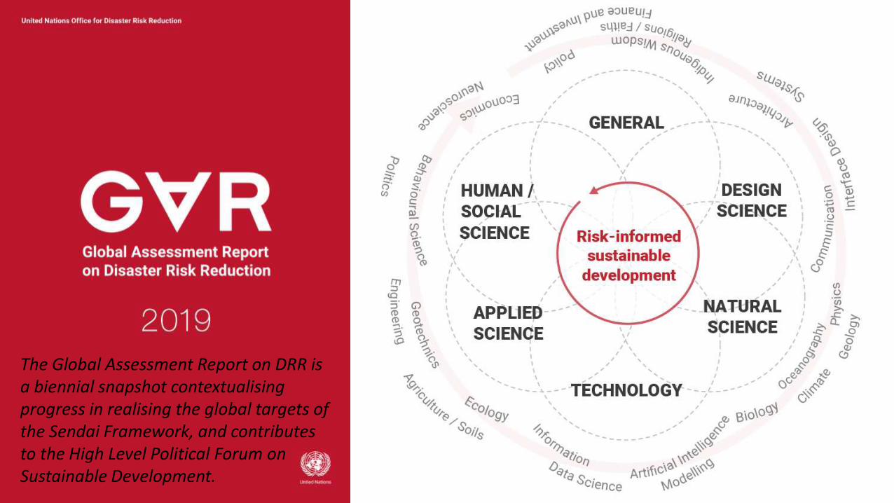
The Global Assessment Report on DRR is a biennial snapshot contextualising progress in realising the global targets of the Sendai Framework, and contributes to the High Level Political Forum on Sustainable Development.
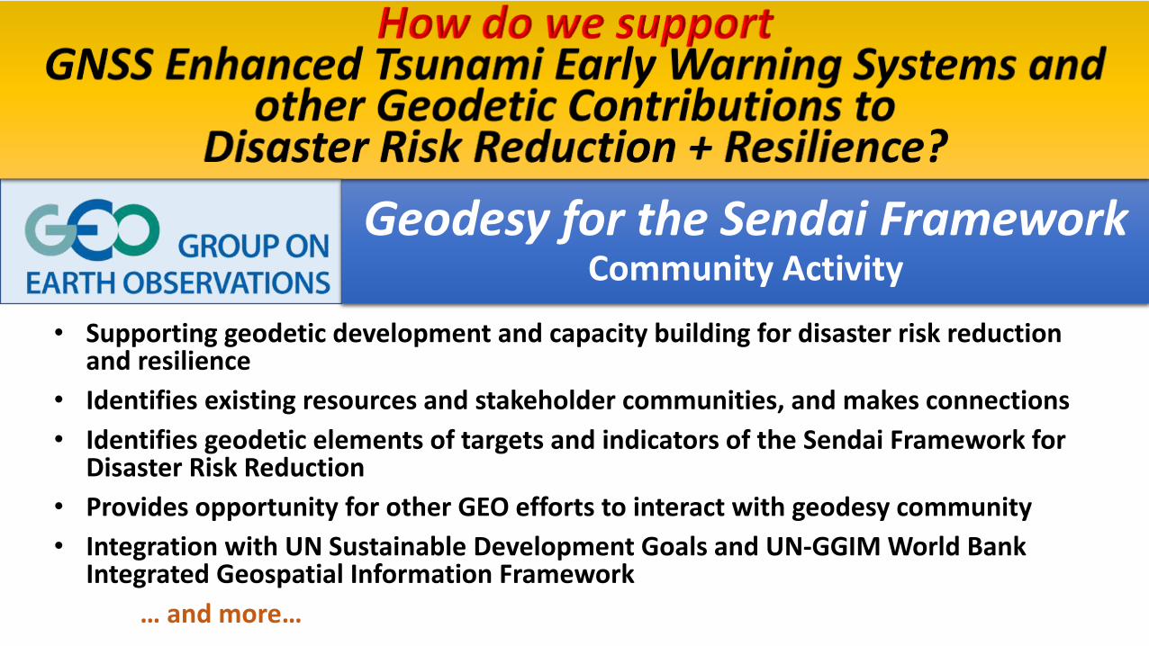
Geodesy for the Sendai FrameworkCommunity Activity
• Supporting geodetic development and capacity building for disaster risk reduction and resilience
• Identifies existing resources and stakeholder communities, and makes connections
• Identifies geodetic elements of targets and indicators of the Sendai Framework for Disaster Risk Reduction
• Provides opportunity for other GEO efforts to interact with geodesy community
• Integration with UN Sustainable Development Goals and UN-GGIM World Bank Integrated Geospatial Information Framework
… and more…
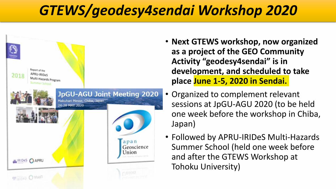
GTEWS/geodesy4sendai Workshop 2020
• Next GTEWS workshop, now organized as a project of the GEO Community Activity “geodesy4sendai” is in development, and scheduled to take place June 1-5, 2020 in Sendai.
• Organized to complement relevant sessions at JpGU-AGU 2020 (to be held one week before the workshop in Chiba, Japan)
• Followed by APRU-IRIDeS Multi-Hazards Summer School (held one week before and after the GTEWS Workshop at Tohoku University)

geodesy4sendai Next Steps
• What does the Geodesy community need from this GEO Community Activity?
• What does the Disaster Risk Reduction + Resilience community need from geodesy?
• How can geodesists better engage with the broader Earth observation and disasters community?
• What resources already exist, and how can we better identify and discover them?
• Where are the gaps in our resources, communications, and capacities?

• Earth observations and derived information have already played key roles in supporting sustainable development. Serving the 2030 Agenda, they can play insightful roles in monitoring targets, planning, tracking progress, and helping nations and other stakeholders make informed decisions, plans, and on-going adjustments that will contribute toward achieving the SDGs.
• Combined with demographic and statistical data, these sources enable nations to analyze and model conditions, create maps and other visualizations, evaluate impacts across sectors and regions, monitor change over time in a consistent and standardized manner, and improve accountability.
Geodesy and the

Disaster Risk Reduction (Sendai Framework)& the SDGs
GEO is working to support the Sendai Framework
and to address disaster-related goals, targets and
indicators of the 2030 Agenda:
• 3 SDGs
• 1: End poverty in all its forms everywhere
• 11: Make cities and human settlements
inclusive, safe, resilient and sustainable.
• 13: Take urgent action to combat climate
change and its impacts
• 4 SDGs Targets
• 11 SDGs indicators
Aligning disaster-related SDGs with the Sendai Framework for Disaster Risk Reduction.

• Image Courtesy UNDRR PreventionWeb

Geodesy Contributions to SDG 11Sustainable Cities and CommunitiesSustainable Development Goal 11 is to make cities and human settlements inclusive, safe, resilient and sustainableTARGET 11.5: By 2030, significantly reduce the number of deaths and the number of people affected and substantially decrease the direct economic losses relative to global gross domestic product caused by disasters, including water-related disasters, with a focus on protecting the poor and people in vulnerable situations
De aquí a 2030, reducir significativamente el número de muertes causadas por los desastres, incluidos los relacionados con el agua, y de personas afectadas por ellos, y reducir considerablemente las pérdidas económicas directas provocadaspor los desastres en comparación con el producto interno bruto mundial, haciendoespecial hincapié en la protección de los pobres y las personas en situaciones de vulnerabilidad
• INDICATOR 11.5.2: Direct disaster economic loss in relation to global GDP, including disaster damage to critical infrastructure and disruption of basic services
• Pérdidas económicas directas en relación con el PIB mundial, daños en la infraestructura esencial y número de interrupciones de los servicios básicosatribuidos a desastres.

Geodesy Contributions to SDG 11Sustainable Cities and CommunitiesSustainable Development Goal 11 is to make cities and human settlements inclusive, safe, resilient and sustainable
TARGET 11.6: By 2030, reduce the adverse per capita environmental impact of cities, including by paying special attention to air quality and municipal and other waste managementDe aquí a 2030, reducir el impacto ambiental negativo per capita de las ciudades, incluso prestando especial atención a la calidad del aire y la gestión de los desechos municipales y de otro tipo
• INDICATOR 11.6.2: Annual mean levels of fine particulate matter (e.g. PM2.5 and PM10) in cities (population weighted)
• Niveles medios anuales de partículas finas en suspensión (por ejemplo, PM2.5 y PM10) en las ciudades (ponderados según la población)

Geodesy Contributions to SDG 11Sustainable Cities and CommunitiesSustainable Development Goal 11 is to make cities and human settlements inclusive, safe, resilient and sustainable
TARGET 11.B: By 2020, substantially increase the number of cities and human settlements adopting and implementing integrated policies and plans towards inclusion, resource efficiency, mitigation and adaptation to climate change, resilience to disasters, and develop and implement, in line with the Sendai Framework for Disaster Risk Reduction 2015-2030, holistic disaster risk management at all levels
De aquí a 2020, aumentar considerablemente el número de ciudades y asentamientos humanos que adoptan e implementan políticas y planes integradospara promover la inclusión, el uso eficiente de los recursos, la mitigación del cambio climático y la adaptación a él y la resiliencia ante los desastres, y desarrollar y poner en práctica, en consonancia con el Marco de Sendai para la Reducción del Riesgo de Desastres 2015-2030, la gestión integral de los riesgos de desastre a todos los niveles
• INDICATOR 11.B.2: Number of countries with national and local disaster risk reduction strategies
• Proporción de gobiernos locales que adoptan y aplican estrategias locales de reducción del riesgo de desastres en consonancia con las estrategias nacionalesde reducción del riesgo de desastres
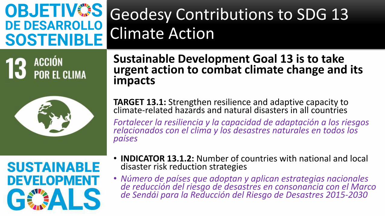
Sustainable Development Goal 13 is to take urgent action to combat climate change and its impacts
TARGET 13.1: Strengthen resilience and adaptive capacity to climate-related hazards and natural disasters in all countries
Fortalecer la resiliencia y la capacidad de adaptación a los riesgosrelacionados con el clima y los desastres naturales en todos los países
• INDICATOR 13.1.2: Number of countries with national and local disaster risk reduction strategies
• Número de países que adoptan y aplican estrategias nacionalesde reducción del riesgo de desastres en consonancia con el Marco de Sendái para la Reducción del Riesgo de Desastres 2015-2030
Geodesy Contributions to SDG 13Climate Action

Sustainable Development Goal 13 is to take urgent action to combat climate change and its impacts
TARGET 13.3: Improve education, awareness-raising and human and institutional capacity on climate change mitigation, adaptation, impact reduction and early warning
Mejorar la educación, la sensibilización y la capacidad humana e institucional respecto de la mitigación del cambio climático, la adaptación a él, la reducción de sus efectos y la alerta temprana
• INDICATOR 13.3.1: Number of countries that have integrated mitigation, adaptation, impact reduction and early warning into primary, secondary and tertiary curricula
• Número de países que han incorporado la mitigación del cambio climático, la adaptación a él, la reducción de sus efectos y la alerta temprana en los planes de estudios de la enseñanza primaria, secundaria y terciaria
• INDICATOR 13.3.2: Number of countries that have communicated the strengthening of institutional, systemic and individual capacity-building to implement adaptation, mitigation and technology transfer, and development actions
• Número de países que han comunicado una mayor creación de capacidad institucional, sistémica e individual para implementar actividades de adaptación, mitigación y transferencia de tecnología, y medidas de desarrollo
Geodesy Contributions to SDG 13Climate Action

jpl.nasa.gov
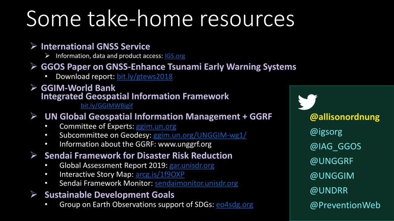
Some take-home resources International GNSS Service
Information, data and product access: IGS.org
GGOS Paper on GNSS-Enhance Tsunami Early Warning Systems• Download report: bit.ly/gtews2018
GGIM-World BankIntegrated Geospatial Information Framework • Phase 1: bit.ly/GGIMWBigif
UN Global Geospatial Information Management + GGRF• Committee of Experts: ggim.un.org• Subcommittee on Geodesy: ggim.un.org/UNGGIM-wg1/• Information about the GGRF: www.unggrf.org
Sendai Framework for Disaster Risk Reduction• Global Assessment Report 2019: gar.unisdr.org• Interactive Story Map: arcg.is/1f9OXP• Sendai Framework Monitor: sendaimonitor.unisdr.org
Sustainable Development Goals• Group on Earth Observations support of SDGs: eo4sdg.org
@allisonordnung
@igsorg
@IAG_GGOS
@UNGGRF
@UNGGIM
@UNDRR
@PreventionWeb