Embed Size (px)
Citation preview

HFIP Global Model/Physics Working Group Report – Nov2011
Goal: Advanced global model for improved
TC forecasting
Stan Benjamin, John Brown - NOAA/ESRL +Rainer Bleck, Susan Sahm, Shan Sun, J-W Bao, Georg Grell, Tom Henderson, Mike Fiorino, Phil Pegion, Jeff Whitaker Jim Ridout (et al.) - NRL S.-J. Lin (et al.) - GFDL S. Moorthi, M. Iredell, Fanglin Yang - NCEP/EMC
FY11 highlights FIM development and testing Performance update FY12 proposed plans and milestones
15km FIM – 10m V 48h - Cyclone Yasi

FIM purpose and configurations
Purpose: A next-generation global model for NOAA (candidate for NCEP ops, coupled model research)
Resolution
• Real-time testing at 60km, 30km, 15km resolution - icosahedral horizontal grid
• 64 vertical levels – hybrid θ-σ
• Ptop = 0.5 hPa, -top = 2200K
Physics
• Currently GFS physics suite (2010 version)
Initial conditions • GFS/GSI spectral data to FIM icos hybrid θ-σ vertical coordinate • Ensemble Kalman using GFS T254 – Jeff Whitaker, ESRL Application at NCEP Likely application in GEFS, candidate for future global model

FIM – Most important model changes since 2010 hurricane season
1. Corrected CO2 error – Jan 11 • Was erroneously set =0 in fall 2010 real-time runs • Discovered NCEP “secret” – value of CO2 ppm moved to run-time
script with July 2010 version of GFS (instead of inside code as prior to July)
• Reason for poorer real-time FIM performance in fall 2010 than in 2009
2. Corrected numerical error in flux-corrected transport – Apr 11 • Outcome from investigation of broader than expected tropical
cyclones – focused on Cyclone Yasi (Queensland landfall – 2 Feb 2011) • Error would not have been found without HFIP project with TC focus
3. Corrected version recommended for Stream 1.5 by TCMT after 2008/2009/2010 reruns

GFS vs. FIM – 250 hPa winds 72h forecasts verified against raobs
N. America Tropics – 20N to 20S
2008 2009 2010 2011 2008 2009 2010 2011
GFS better FIM better
GFS better FIM better
Jan 2011 – CO2 fix April 2011 – FCT fix

GFS vs. FIM – 850 hPa winds 72h forecasts verified against raobs
GFS better FIM better
2008 2009 2010 2011

2009-2010 reruns with corrected FIM (and with EnKF initial conditions) – LANT/EPAC

Tropical wind forecasts – FIM vs GFS, both verified against ECMWF analyses – RMS vector
From http://www.emc.ncep.noaa.gov/gmb/wx24fy/fimy/
FIM – significant improvement over GFS in tropical upper-level winds (at 200 hPa), little difference in lower troposphere
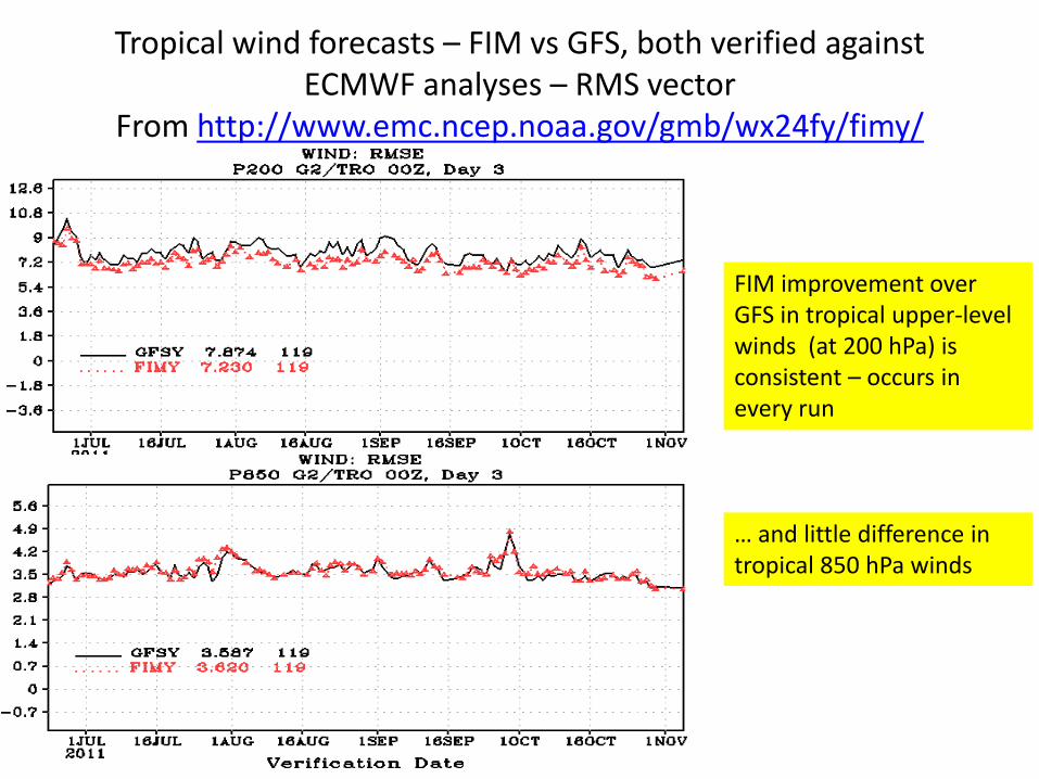
Tropical wind forecasts – FIM vs GFS, both verified against ECMWF analyses – RMS vector
From http://www.emc.ncep.noaa.gov/gmb/wx24fy/fimy/
FIM improvement over GFS in tropical upper-level winds (at 200 hPa) is consistent – occurs in every run
… and little difference in tropical 850 hPa winds

Resolution Init conds
Physics Stream 1.5
FIM 30km GSI GFS (July 2010) No
FIMY - Stream 1.5
30km EnKF GFS Yes
FIM9 15km EnKF GFS No
FIMX 60km GSI/cyc chem
GFS + WRF-chem, testing of Grell cu
No
FIM7 60km GSI GFS No
FIMens 60km, 10mem
EnKF GFS No
FIMens 27km, 4mem
EnKF GFS No
Versions of FIM running – Fall 2011

HFIP Global EnKF using GFS and FIM: Ophelia and Hilary Initialized 00z Wednesday 21 Sep 2011
Soon-to-be Hilary
Ophelia

120h 10-m FIM Forecasts from 00Z 22 Sep 2011 Hilary and Ophelia – scale dependence
60 Km 30 Km
15 Km
Hilary
Ophelia
One might expect that the higher resolution runs would produce the smallest, strongest storms. Here, Ophelia is smaller (radius of max wind) at higher resolution, but strongest (in terms of 10-m wind speed) at 30km. Hilary is strongest at 15km, largest, as expected, at 60km.

Ophelia – track forecasts

00Z 21 Sep 2011 initial time GFS/EnKF ensemble: contrasting views of Hilary and Ophelia
Ophelia: 168-h valid 00z 28 September Hilary: 168-h valid 00z 28 September
Only 2 members strengthen Ophelia, while all the members strengthen Hilary, with a couple of members much faster turning it to the NNE.

Example of FIM forecast (Ophelia) Initial time: 00Z 21 Sep 2011
• Ophelia first strengthens in most of the members, then by 120h it has weakened in most members as it passes W of ~ 55W.
• Next few slides show the sequence (every 12h) of the individual 60km FIM ensemble-member forecasts of 10-m wind.
• Lowest image in middle column is from the EnKF-initialized G8 (30-km) run, others are G7 (60km).

00z 21 Sep 2011 initial 10-m wind
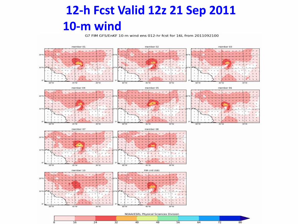
12-h Fcst Valid 12z 21 Sep 2011 10-m wind
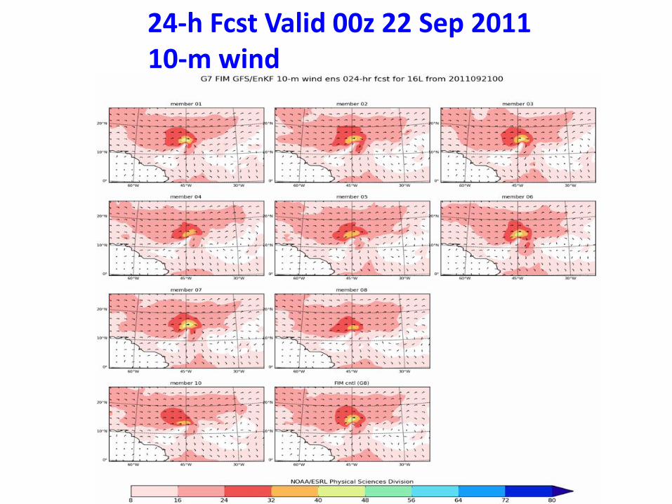
24-h Fcst Valid 00z 22 Sep 2011 10-m wind

36-h Fcst Valid 12z 22 Sep 2011 10-m wind
This is about time of peak intensity for most of the members

48-h Fcst Valid 00z 23 Sep 2011 10-m wind
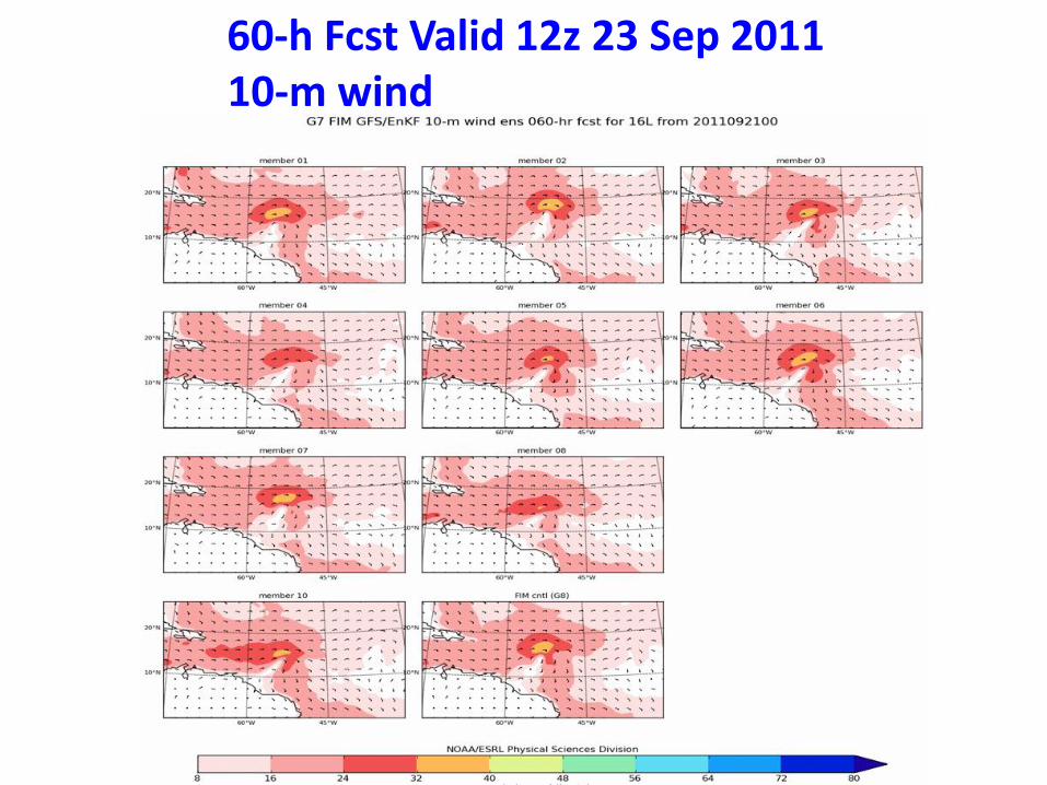
60-h Fcst Valid 12z 23 Sep 2011 10-m wind

72-h Fcst Valid 00z 24 Sep 2011 10-m wind

84-h Fcst Valid 12z 24 Sep 2011 10-m wind

96-h Fcst Valid 00z 25 Sep 2011 10-m wind

108-h Fcst Valid 12z 25 Sep 2011 10-m wind

120-h Fcst Valid 00z 26 Sep 2011 10-m wind
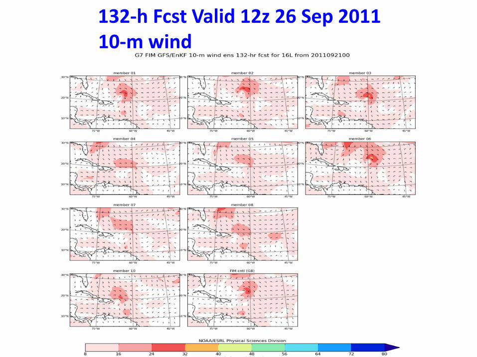
132-h Fcst Valid 12z 26 Sep 2011 10-m wind

144-h Fcst Valid 00z 27 Sep 2011 10-m wind

156-h Fcst Valid 12z 27 Sep 2011 10-m wind

168-h Fcst Valid 12z 27 Sep 2011 10-m wind

Atlantic – 2011 - track
= FIM with GFS/GSI IC
From NCEP verification - http://www.emc.ncep.noaa.gov/gmb/wx24fy/fim

Atlantic – 2011 - intensity From NCEP verification - http://www.emc.ncep.noaa.gov/gmb/wx24fy/fim

E.Pacific - 2011 From NCEP verification - http://www.emc.ncep.noaa.gov/gmb/wx24fy/fim

Fiorino stat summary 2011
N. Hem - track Key points • FIMY (EnKF IC) better than FIM (GFS IC), similar for GFS • FIM/GFS and GFS-only ensembles beat determ models • FIM/GFS and GFS-only ensembles matches ECMWF
@120h • FIM needs physics diversity from GFS

Fiorino stat summary 2011
LANT - intensity
Key points • Global models had low bias in 2011 • LGEM provides lowest bias • FIM had lowest mean intensity error

FIM Development at NCEP
Strong progress toward NCEP operational status
• Preliminary tests of FIM done on NCEP CCS
• MOA with NCEP to run FIM as part of Global Ensemble Forecast System (GEFS) under NEMS.
• GSD’s Advanced Computing Group worked closely with NEMS developers at NCEP to work out basic NEMS design issues as well as to get FIM under NEMS
• Testing of FIM to start within NEMS GEFS framework at NCEP in next few months
• NCEP doing their own verification now of FIM
• 38-level version of FIM tested – equal performance with L64 – readiness for GEFS. (Fewer levels should fare well with isentropic-hybrid coordinate …. and apparently do)
HFIP Global Model/Physics Team plans for FY12
• FIM - Testing in GEFS under NEMS
• Model enhancements toward efficiency
• Testing of WRF physics (Grell cumulus), other physics – Critical for improving tropical cyclone diversity
• Physics – diversity between GFS and FIM should improve multi-model TC ensemble – Grell 3-d convective scheme – now in testing
– FIM-chem with more complex microphysics (2-moment cloud at least) for coupling with aerosol (Saharan dust, sea salt, etc.) – Georg Grell
– Stochastic physics, other devices to increase ensemble diversity – Jian-Wen Bao, Georg
• Continued development of CFIM (coupled atmosphere-ocean FIM with icos HYCOM)
• Use of long runs for evaluation of FIM TC climate and diagnosis of physics problems
• Continue work toward FIM-based EnKF-hybrid (Phil Pegion, Jeff W)

NRL global model progress from NOGAPS to NAVGEM for tropical cyclones
(from Jim Ridout at NRL-Monterey) • Results for Summer 2010 - reanalysis
– improved results at 120-hr for NAVGEM vs. NOGAPS • Results for 2011 (just being assessed)
– Mixed between NAVGEM and NOGAPS – Overall, TC track errors appear comparable – Current work is being focused on adjustments to the new
physics, particularly the Simplified Arakawa Schubert cumulus scheme.
– Enhancements to the radiation scheme (testing the RRTMG scheme) and incorporation of a prognostic cloud scheme are also in progress.
– The adoption in NAVGEM of semi-lagrangian moisture advection scheme expected to help enable faster transitions to higher resolutions than would be possible with NOGAPS."

Summary for Global Modeling Progress • Significant improvement in FIM in last year –
2011 was breakthrough year – improvement over GFS in wind forecasts at all levels,
especially in tropics
– Tropical cyclone improvement – achieved Stream 1.5 after successful retro runs and recommendation by TCMT (EnKF initialization – FIMY)
– FIM “competitive” with GFS for track, best global model for intensity

Proposed 2012 Milestones—ESRL global model and assimilation efforts
1. Develop improved version of FIM global model ready for testing in 2012 hurricane season. (improved numerics, improved/diversified physics) 2. Develop improved version of global ensemble data assimilation ready for real-time operations in 2012 hurricane season. Collaborate with regional modeling (for initial conditions) and ensemble data assimilation (for lateral boundary condition) efforts (Jeff Whitaker)
3. Conduct real-time demonstration in 2012 hurricane season of FIM model and GFS model run in both • high-resolution deterministic (10-15km FIM) • medium-resolution ensemble configurations (down to 27-30km FIM) --- Initialization with experimental advanced (ensemble / EnKF / hybrid) initial conditions (Jeff Whitaker, Phil Pegion) for advanced versions of FIM and GFS global models

30km FIM 48h fcst Cyc Yasi 10m wind

15km FIM 48h fcst Cyc Yasi 10m wind

48h fcst - Cyclone Yasi -10m wind (not at same time)
30km FIM 15km FIM