Embed Size (px)
Citation preview

1
Global Positioning System (GPS)EE 442 – Spring Semester
Lecture 15
Before GPS we had “follow the stars.” sextant, chronometer, and radio such as Loran. First satellite navigation was TRANSIT.

2
• Position and coordinates
• Distance and direction between two waypoints
• Travel progress reports
• Accurate time measurements
The Four Basic Functions of GPS

3
An Early Satellite Navigation System – TRANSIT (1964 to 1968)
http://electronicstechnician.tpub.com/14090/css/An-Wrn-5-V-Radio-Navigation-Set-19.htm
TRANSIT (aka NAVSAT & NNSS)
Location for naval Polaris ballistic missile submarines.
Based upon Doppler shift with150 MHz and 400 MHz signals.
By 1968 TRANSIT had 36 satellites in polar orbits.
A satellite moves at 17,000 mph. Dopp
ler s
hift

4
The Global Positioning System (GPS), originally NAVSTAR GPS,is a satellite-based radio-navigation system owned by the United States government and operated now by the United States Space Force. It is one of the global navigation satellite systems (GNSS) that provides geolocation and time information to a GPS receiver anywhere on or near the Earth where there is an unobstructed line of sight to four or more GPS satellites. Obstacles such as mountains and buildings block the relatively weak GPS signals. Five ground stations support GPS.
NAVSTAR – Global Positioning System (GPS)

5
GPS is a World-Wide Radio-Navigation SystemA World-wide radio-navigation system using “man-made stars” (i.e., satellites) for referencing positions on the Earth, calculating position (accurate to matter of meters). Can also determine speed, bearing, tacking, distance to destination and sunrise and sunset times.
GPS Receiverhttps://technicalrashmi.blogspot.com/2017/09/what-is-
global-positioning-system.html
“Man-made stars” for navigation
Signal’s “time-of-flight”
used to finddistance.
6
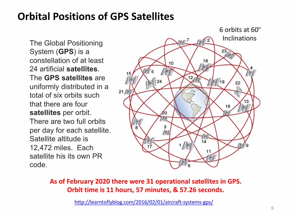
Orbital Positions of GPS Satellites
http://learntoflyblog.com/2016/02/01/aircraft-systems-gps/
The Global Positioning System (GPS) is a constellation of at least 24 artificial satellites. The GPS satellites are uniformly distributed in a total of six orbits such that there are four satellites per orbit.There are two full orbits per day for each satellite.Satellite altitude is 12,472 miles. Each satellite his its own PR code.
As of February 2020 there were 31 operational satellites in GPS. Orbit time is 11 hours, 57 minutes, & 57.26 seconds.
6 orbits at 60°Inclinations

7
Using Trilateration for Determining Position
https://gisgeography.com/trilateration-triangulation-gps/
Trilateration uses distances and not angles (triangulation).
Three satellites work but four
satellites are better.
Satellites signals aresynchronized

8
Measuring distance With GPS PRN Signals
https://www.e-education.psu.edu/natureofgeoinfo/book/export/html/1620

9
Trilateration Requirements
https://www.slideserve.com/donelle/how-gps-works-part-2

History of GPS Introduction
10
The need for a very accurate navigation system come out of the Cold War – the Pentagon begins a feasibility study in the 1960s. Military needs are the motivation for GPS.
In 1963 Aerospace Corporation completed a study of aproposed GPS system for the military (it was approved).
The NAVSTAR program receives funding beginning in 1973 by the Department of Defense.
The first four GPS satellites are launched in 1978.
In April 1995, the 24th satellite is launched and the GPS system becomes fully operational.
In 1989 Magellan Corporation introduces a commercialhand-held GPS navigation receiver (Magellan NAV 1000).
In 2004 Qualcomm developed an “Assisted GPS” to use cellular networks to give a more accurate position.

11
Space, Control and User Segments of GPS
https://www.slideshare.net/chintanmehta007/how-gps-works-14291595

12
Space Segment: GPS Block IIR(M) Satellite
https://www.nbcnews.com/mach/tech/y2k19-there-s-chance-your-gps-system-could-go-haywire-ncna991181
Each satellite weights about 2000 pounds. Seventeen feet acrosssolar panels.Transmit signal is 50 Watts.A 10-year lifetime for eachsatellite before replacement. Solar powered
Antennas

13
Control Segment: Monitor Stations
• Track GPS satellites as they pass overhead• Collects navigation signals, range/carrier measurements, and atmospheric data• Feeds observations to the master control station • Utilizes sophisticated GPS receivers• Provides global coverage from 16 sites: 6 from the U. S. Space Force plus 10 from NGA
https://www.gps.gov/systems/gps/control/

14
Control Segment: Master Control Station
• Provides command and control of the GPS constellation• Uses global monitor station data to compute the precise locations of the satellites• Generates navigation messages for upload to the satellites• Monitors satellite broadcasts and system integrity to ensure constellation health and accuracy• Performs satellite maintenance and anomaly resolution, including repositioning satellites to maintain optimal constellation
https://www.gps.gov/systems/gps/control/

15https://www.gps.gov/systems/gps/control/
Control Segment: Ground Antennas
• Send commands, navigation data uploads, and processor program loads to the satellites• Collects telemetry• Communicates via S-band and perform S-band ranging to provide anomaly resolution and early orbit support• Consist of 4 dedicated GPS ground antennas plus 7 Air Force Satellite Control Network (AFSCN) remote tracking stations

16
Control Segment: Locations
https://www.gps.gov/systems/gps/control/

17
User Segment: GPS Receivers
https://www.garmin.com/en-US/aboutGPS/
https://www.technologyreview.com/2011/09/05/257963/gps-receivers-now-small-enough-to-attach-to-almost-anything/

18
General Information in GPS Signals
The GPS signal has two components:
1. Ephemeris Data – Contains status of the satellite, currentdate and time. This data is constantly transmittedfrom each satellite and is essential for positiondetermination.
2. Almanac Date – Tells GPS receivers where each satellite islocated at any time of the day. Each satellite transmitsalmanac data showing the orbital information of that satellite.

19
Time Accuracy on GPS Satellites Using Atomic Clocks
GPS satellites, each of which has at least two onboard cesium and as many as two rubidium atomic clocks.
The relative times are mathematically transformed into three absolute spatial coordinates and one absolute time coordinate. GPS Time (GPST) is a continuous time scale and theoretically accurate to about 14 ns. However, most receivers lose accuracy in the interpretation of the signals and are only accurate to 100 ns. The GPST is related to but differs from TAI (International Atomic Time) and UTC (Coordinated Universal Time). GPST remains at a constant offset with TAI (TAI – GPST = 19 seconds) and like TAI does not implement leap seconds. Periodic corrections are performed to the on-board clocks in the satellites to keep them synchronized with ground clocks.The GPS navigation message includes the difference between GPST and UTC. As of July 2015, GPST is 17 seconds ahead of UTC because of the leap second added to UTC on 30 June 2015.Receivers subtract this offset from GPS Time to calculate UTC and specific time zone values.

20
Atomic Clocks are the Ultimate in Accuracy
Physicists discovered that atoms of specific elements oscillated at exactly the same rate. In 1967, the atomic clock timing standard was determined to be exactly 9,192,631,770 oscillations per second (Cesium 133 atom resonant frequency).
The 3 types of atomic clocks include cesium, hydrogen, and rubidium.
Cesium Atomic Clocks - cesium atomic clocks employ a beam of cesium atoms. The clock separates cesium atoms of different energy levels by a magnetic field.Hydrogen atomic clocks - Maintain hydrogen atoms at the required energy level in a container with walls of a special material.Rubidium Atomic Clocks - The simplest and most compact of all atomic clocks. They use a glass cell of rubidium gas that changes its absorption of light at the optical rubidium frequency when the surrounding microwave frequency is just right.

21
Atomic Clock Example
https://resources.bliley.com/ar133-series-rubidium-frequency-atomic-clock
The Bliley AR133 Series is a multifunctional Rubidium Standard designed to provide precision timing and reference frequency. It is one of the smallest atomic standards available without sacrificing performance.
AR133 Key features include:
• Long Term Stability 5´10-11/month • -150 dBc/Hz phase noise @ 10kHz • 5´10-12 ADEV @ 100sec • 8.25W steady-state power • 3”x3” (77mmx77mm) package

22
Atomic Clock Stability Improvement
https://physics.stackexchange.com/questions/516265/why-is-there-a-moores-law-for-atomic-clocks
What is the state of the art in time stability?Ans. Instability of 10−17 over an hour-long measurement
picosecond/day
23
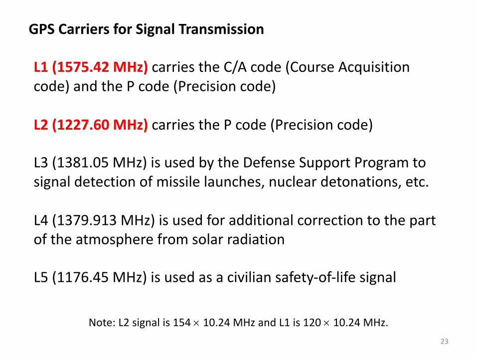
GPS Carriers for Signal Transmission
L1 (1575.42 MHz) carries the C/A code (Course Acquisition
code) and the P code (Precision code)
L2 (1227.60 MHz) carries the P code (Precision code)
L3 (1381.05 MHz) is used by the Defense Support Program to
signal detection of missile launches, nuclear detonations, etc.
L4 (1379.913 MHz) is used for additional correction to the part of the atmosphere from solar radiation
L5 (1176.45 MHz) is used as a civilian safety-of-life signal
Note: L2 signal is 154 ´ 10.24 MHz and L1 is 120 ´ 10.24 MHz.

24
Two Main GPS Carrier SignalsThe GPS satellites transmit signals on two carrier frequencies. The L1carrier is 1575.42 MHz and carries both the status message and a pseudo-random code for timing. The L2 carrier is 1227.60 MHz and is used for the more precise militarypseudo-random code.
http://wireless.ictp.it/school_2001/labo/GPS/PRC.HTM

25
The L1 GPS Signal
https://gssc.esa.int/navipedia/index.php/File:GPS_Signals.png
Binary Phase Shift Keyed
The transmitted L1 signal uses binary phase shift keying.

26
Pseudo-Random Codes (Two types)
The first pseudo-random code is called the C/A (Coarse Acquisition) code. It modulates the L1 carrier. It repeats every 1023 bits and modulates at a 1MHz rate. Each satellite has a unique pseudo-random code. The C/A code is the basis for civilian GPS use.
The second pseudo-random code is called the P (Precise) code. It repeats on a seven-day cycle and modulates both the L1 and L2 carriers at a 10MHz rate. This code is intended for military users and can be encrypted – when encrypted it's called the "Y" code.
Navigation Message
There is a low frequency signal added to the L1 codes that gives information about the satellite's orbits, their clock corrections and other system status. Frequency is 50 Hz.
Pseudo-Random Codes in GPS

27
Time Standards
Universal Coordinated Time (UTC)
GreenwichMean Time
(GMT)
GPS Time+ T(sec)
Zulu Time(military)
Local Time: AM and PM (adjust for local time zone)
Military time (local time on a 24-hour clock)

28
Universal Coordinated Time Standard
Coordinated Universal Time (or UTC) is the primary time standard by which the world regulates clocks and time. It is within about 1 second of mean solar time at 0° longitude. It is effectively a successor to Greenwich Mean Time (GMT).
The current version of UTC is defined by the International Telecommunications Union Recommendation (ITU-R TF.460-6), Standard-frequency and time-signal emissions, and is based on International Atomic Time (TAI) with leap seconds added at irregular intervals to compensate for the slowing of the Earth's rotation.
UTC is used in many Internet and World Wide Web standards. UTC is 7 hours ahead of Mountain Standard Time (Santa Rosa, CA).
https://en.wikipedia.org/wiki/Coordinated_Universal_Time
Clock: https://time.is/UTC

29
GPS Time Accuracy
https://www.slideshare.net/jawadali19252/gps-ppt-33758814?next_slideshow=1
The position calculated by a GPS receiver relies on
Current time,Satellite position, andTime delay for the signal.
The GPS signal in space will provide a “worst case” accuracy of 7.8 meters at a 95% confidence limit.
GPS time is accurate to about 14 nanoseconds. But this is degraded by transmission and receiver errors.
Higher accuracy is available today by using GPS incombination with augmentation systems. These canenable real-time positioning to within a meter.
30
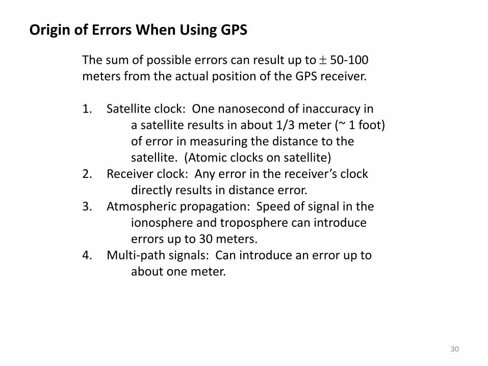
Origin of Errors When Using GPS
The sum of possible errors can result up to ± 50-100 meters from the actual position of the GPS receiver.
1. Satellite clock: One nanosecond of inaccuracy ina satellite results in about 1/3 meter (~ 1 foot)of error in measuring the distance to the satellite. (Atomic clocks on satellite)
2. Receiver clock: Any error in the receiver’s clockdirectly results in distance error.
3. Atmospheric propagation: Speed of signal in theionosphere and troposphere can introduce errors up to 30 meters.
4. Multi-path signals: Can introduce an error up toabout one meter.

31
Source of Errors in GPS
Ionosphere: Electrically charged particles 80 to 120 miles above Earth affects the speed of electromagnetic waves. The change in the speed depends upon the frequency so the L1 and L2 signals propagate at different speeds.
Tropospheric water vapor: Affects attenuation of signalat all frequencies. Difficult to correct for this effect.
Multipath propagation: Reflected waves near the receiveraffect the reading of the time of flight.
Poor visibility: Due to trees and other obstacles. This is why GPS is not well received indoors.
Noise: Combined effect of PRN noise and receiver noise.

32
Limitations in GPS Use
GPS satellite signals are weak; it doesn’t work well inindoors (in buildings), underwater and under trees.
Highest accuracy requires line-of-sight satellite-to-receiver; it generally doesn’t work as well in urbanenvironments. Errors can result in GPS readings whereobstacles interfere with the GPS signals.
The Department of Defense (DoD)can at any time shut down the GPS system (i.e., degrade performance orcompletely shut it off).for any reason.
Some GPS receivers are sensitive to low batteryvoltage as the battery ages.

33
Other GPS Systems in the World
In addition the U. S. GPS system, other countries areDeploying their own GPS systems.
Russia: GLOSNASS (Global Navigation Satellite System)Fully operational; comparable to GPS
European Union: Galileo Positioning SystemNow fully operational; better accuracy than GPS
India: Indian Regional Navigational Satellite System (IRNSS)Presently only seven operational satellites up
China: BeiDou Navigation Satellite System (BDS)Operational with 33 satellites; Better accuracy x 3

34
Assisted or Augmented GPS for Cellular Phone Use
https://en.wikipedia.org/wiki/Assisted_GPS
Assisted GPS or Augmented GPS is a system that often significantly improves the startup performance (i.e., time-to-first-fix (TTFF)) of a GPS satellite-based positioning system. A-GPS is extensively used with GPS-capable cellular phones, as its development was accelerated by the U.S. FCC's 911 requirement to make cell phone location data available to emergency call dispatchers.

35
When you use assisted GPS this whole process is much faster. Cellular network towers have GPS receivers and those receivers are constantly pulling down satellite information and computing the data. This data is then passed on to the cellular phone (when requested) since the relevant satellites to your location are already identified and all GPS computations can be handled by 3rd party computers. The result to the end user is:
• Faster location acquisition• Less processing power is required by your device• Saves battery life• Location acquisition indoors or in non-optimal environmental
settings
Assisted or Augmented GPS for Cellular Phone Use
https://www.windowscentral.com/gps-vs-agps-quick-tutorial
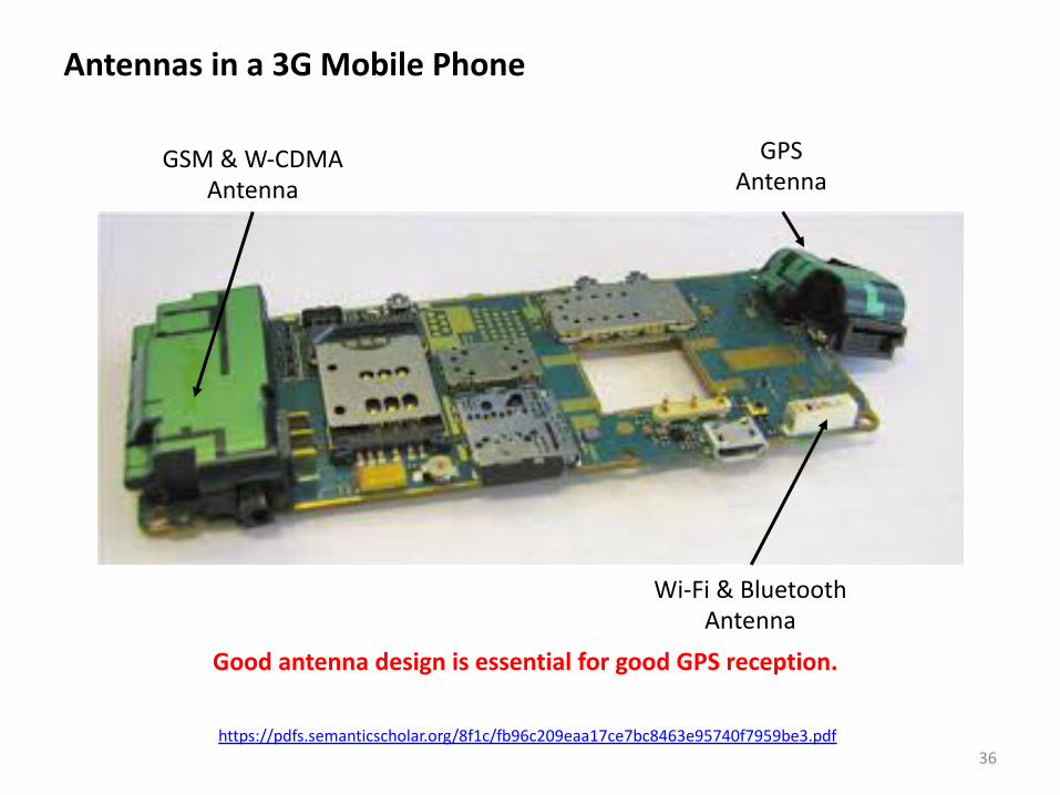
36https://pdfs.semanticscholar.org/8f1c/fb96c209eaa17ce7bc8463e95740f7959be3.pdf
GSM & W-CDMAAntenna
GPSAntenna
Wi-Fi & BluetoothAntenna
Antennas in a 3G Mobile Phone
Good antenna design is essential for good GPS reception.

37
Questions
38
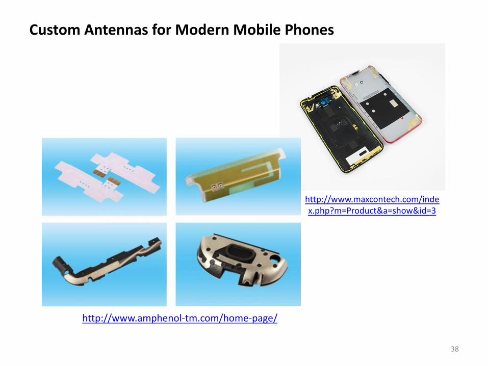
Custom Antennas for Modern Mobile Phones
http://www.amphenol-tm.com/home-page/
http://www.maxcontech.com/index.php?m=Product&a=show&id=3


![GPS [ Global Positioning System ]](https://img.pdfslide.net/doc/110x75/5594407a1a28abde5b8b483f/gps-global-positioning-system-.jpg)


![GPS[Global Positioning System]](https://img.pdfslide.net/doc/110x75/55d4dcedbb61ebca1d8b4633/gpsglobal-positioning-system-55d6c4def19ba.jpg)