Embed Size (px)
Citation preview
1
Global Space-based Inter-Calibration System (GSICS)
Mitchell D. GoldbergNOAA/NESDIS
Center for SaTellite Applications and Research (STAR)Satellite Meteorology and Climate Division
2
Motivation
• Applications are becoming more demanding
• Demanding applications require accurate, well calibrated & characterized measurements
• Reduce measurement uncertainty
• Growing global observing system
3
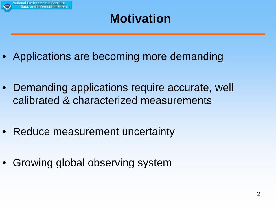
GEOSS
• GEOSS – international coordinated effort to share Earth observations to provide a level of information about the Earth not previously achieved.
4
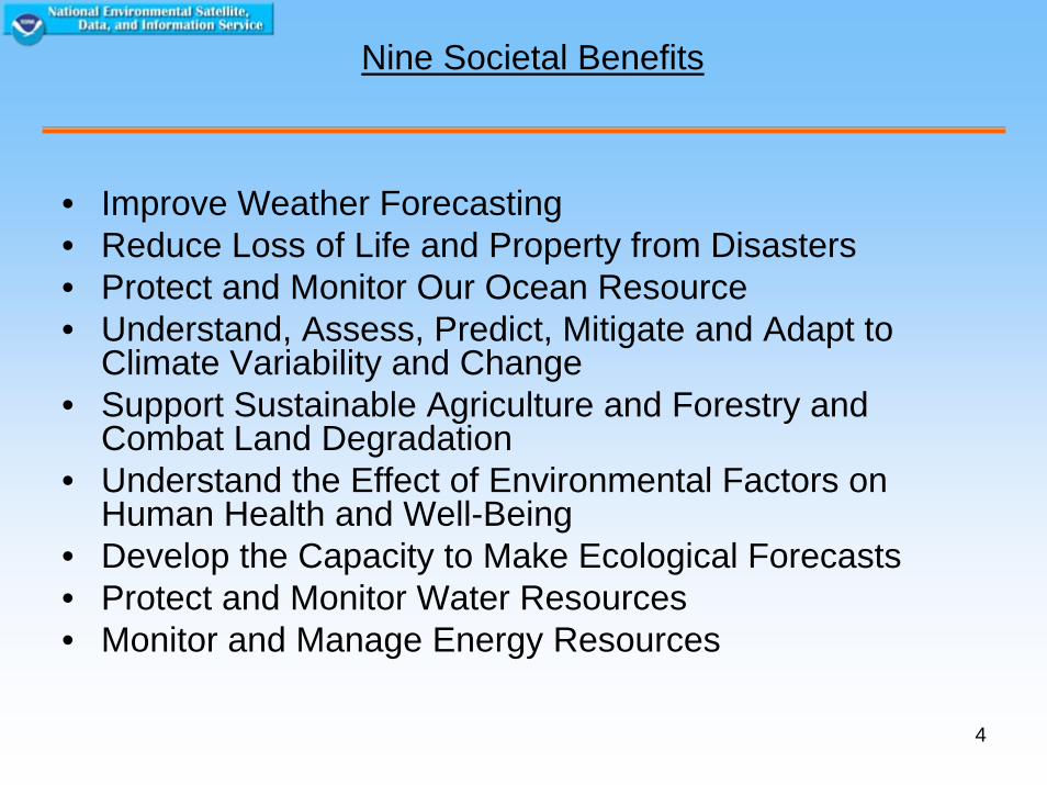
Nine Societal Benefits
• Improve Weather Forecasting• Reduce Loss of Life and Property from Disasters• Protect and Monitor Our Ocean Resource• Understand, Assess, Predict, Mitigate and Adapt to
Climate Variability and Change• Support Sustainable Agriculture and Forestry and
Combat Land Degradation• Understand the Effect of Environmental Factors on
Human Health and Well-Being• Develop the Capacity to Make Ecological Forecasts• Protect and Monitor Water Resources• Monitor and Manage Energy Resources
5
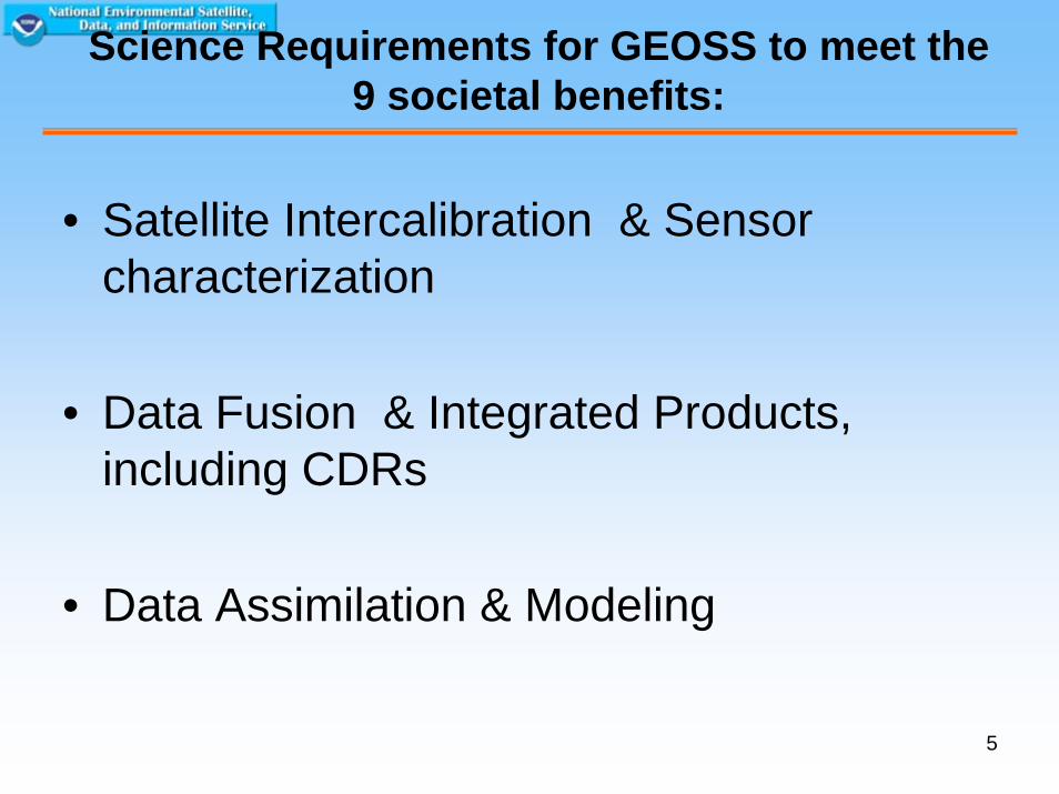
Science Requirements for GEOSS to meet the 9 societal benefits:
• Satellite Intercalibration & Sensor characterization
• Data Fusion & Integrated Products, including CDRs
• Data Assimilation & Modeling
6
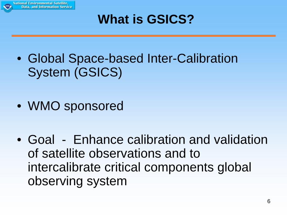
What is GSICS?
• Global Space-based Inter-Calibration System (GSICS)
• WMO sponsored
• Goal - Enhance calibration and validation of satellite observations and to intercalibrate critical components global observing system
7
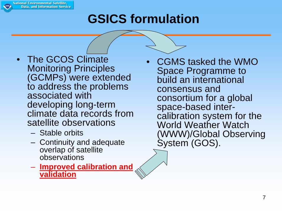
GSICS formulation
• The GCOS Climate Monitoring Principles (GCMPs) were extended to address the problems associated with developing long-term climate data records from satellite observations– Stable orbits – Continuity and adequate
overlap of satellite observations
– Improved calibration and validation
• CGMS tasked the WMO Space Programme to build an international consensus and consortium for a global space-based inter-calibration system for the World Weather Watch (WWW)/Global Observing System (GOS).
8
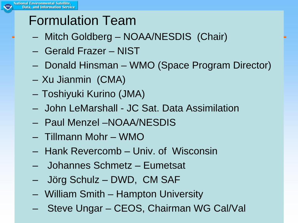
Formulation Team– Mitch Goldberg – NOAA/NESDIS (Chair)– Gerald Frazer – NIST – Donald Hinsman – WMO (Space Program Director) – Xu Jianmin (CMA)– Toshiyuki Kurino (JMA)– John LeMarshall - JC Sat. Data Assimilation – Paul Menzel –NOAA/NESDIS – Tillmann Mohr – WMO – Hank Revercomb – Univ. of Wisconsin – Johannes Schmetz – Eumetsat– Jörg Schulz – DWD, CM SAF – William Smith – Hampton University– Steve Ungar – CEOS, Chairman WG Cal/Val

9
Climate & Weather Requirements
• Need excellent accuracy and long-term stability
• Instruments must be inter-calibrated
• Need high precision (low noise)
• Measurements must be well characterized
10
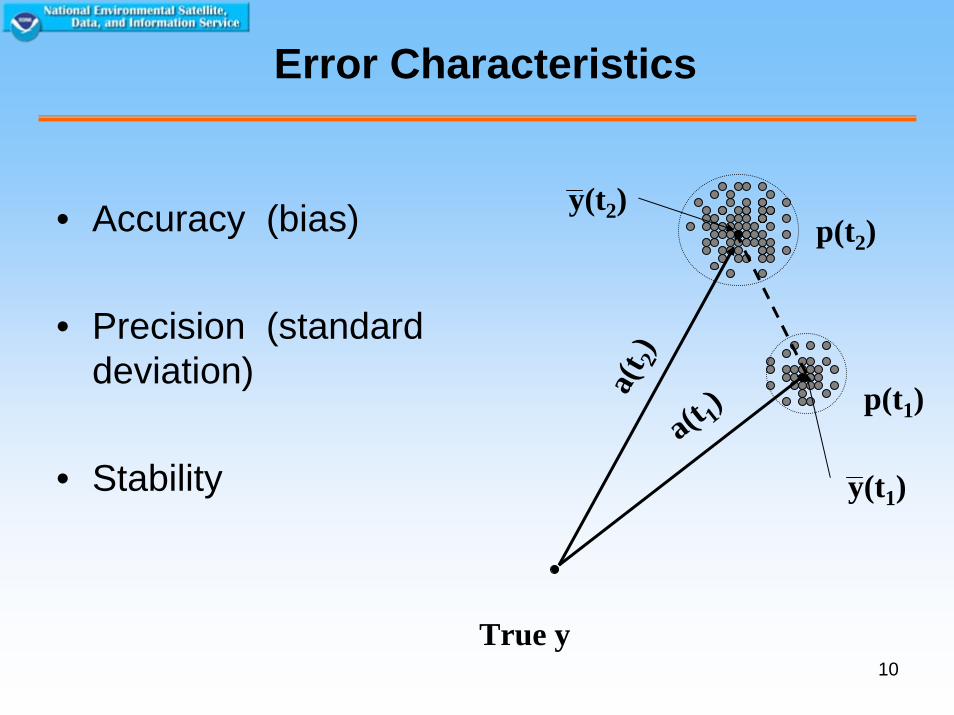
Error Characteristics
• Accuracy (bias)
• Precision (standard deviation)
• Stability
True y
a(t 1)
a(t 2)
p(t1)
p(t2)
y(t1)
y(t2)
11
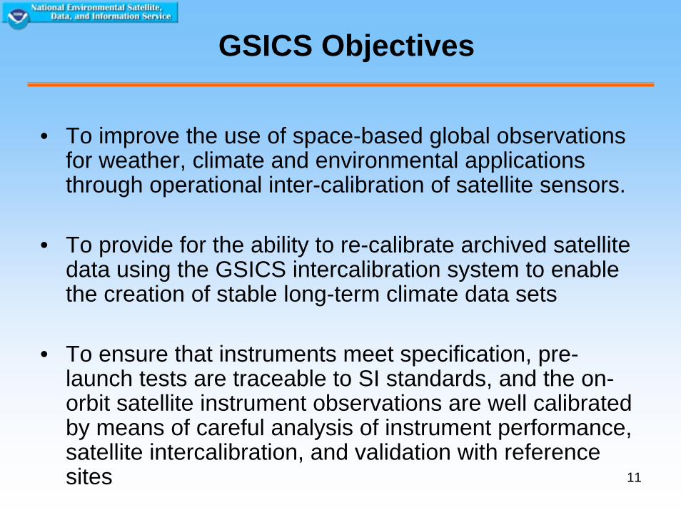
GSICS Objectives
• To improve the use of space-based global observations for weather, climate and environmental applications through operational inter-calibration of satellite sensors.
• To provide for the ability to re-calibrate archived satellite data using the GSICS intercalibration system to enable the creation of stable long-term climate data sets
• To ensure that instruments meet specification, pre-launch tests are traceable to SI standards, and the on-orbit satellite instrument observations are well calibrated by means of careful analysis of instrument performance, satellite intercalibration, and validation with reference sites
12
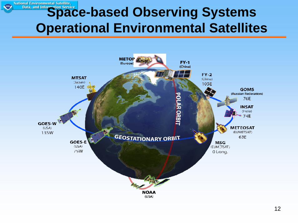
Space-based Observing SystemsOperational Environmental Satellites
13
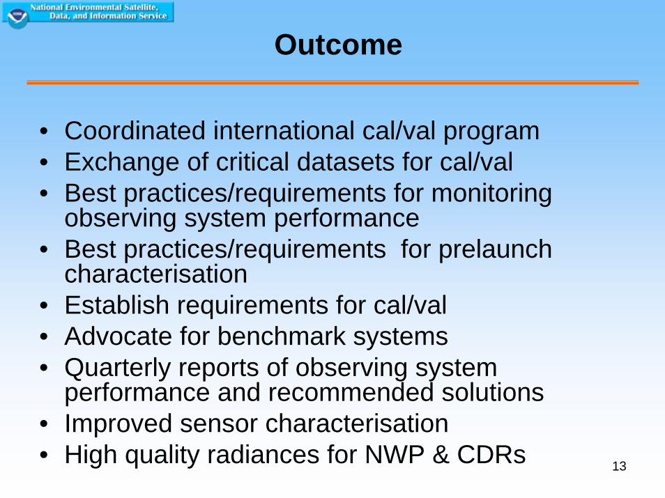
Outcome
• Coordinated international cal/val program• Exchange of critical datasets for cal/val• Best practices/requirements for monitoring
observing system performance• Best practices/requirements for prelaunch
characterisation• Establish requirements for cal/val• Advocate for benchmark systems• Quarterly reports of observing system
performance and recommended solutions• Improved sensor characterisation• High quality radiances for NWP & CDRs
14
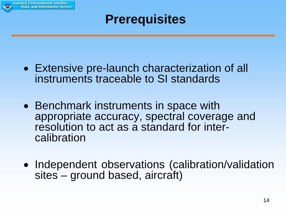
Prerequisites
• Extensive pre-launch characterization of all instruments traceable to SI standards
• Benchmark instruments in space with appropriate accuracy, spectral coverage and resolution to act as a standard for inter-calibration
• Independent observations (calibration/validation sites – ground based, aircraft)
15
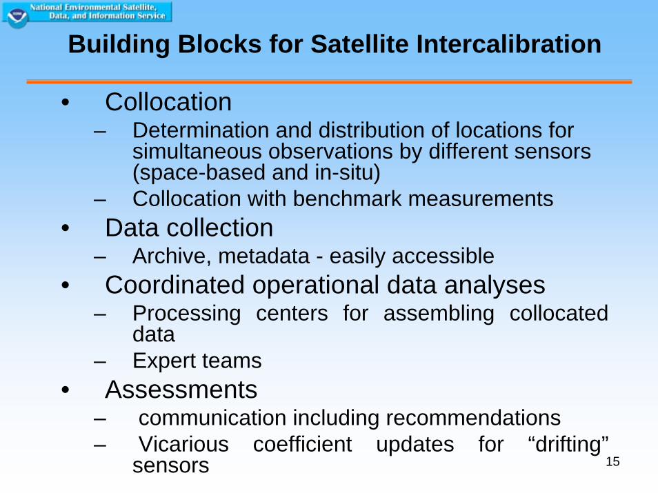
Building Blocks for Satellite Intercalibration
• Collocation– Determination and distribution of locations for
simultaneous observations by different sensors (space-based and in-situ)
– Collocation with benchmark measurements• Data collection
– Archive, metadata - easily accessible• Coordinated operational data analyses
– Processing centers for assembling collocated data
– Expert teams• Assessments
– communication including recommendations– Vicarious coefficient updates for “drifting”
sensors
16
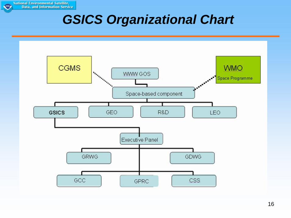
GSICS Organizational Chart
17
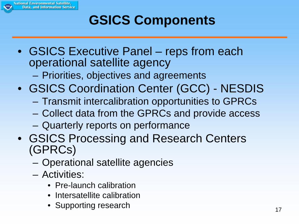
GSICS Components
• GSICS Executive Panel – reps from each operational satellite agency– Priorities, objectives and agreements
• GSICS Coordination Center (GCC) - NESDIS– Transmit intercalibration opportunities to GPRCs– Collect data from the GPRCs and provide access– Quarterly reports on performance
• GSICS Processing and Research Centers (GPRCs) – Operational satellite agencies– Activities:
• Pre-launch calibration• Intersatellite calibration• Supporting research
18
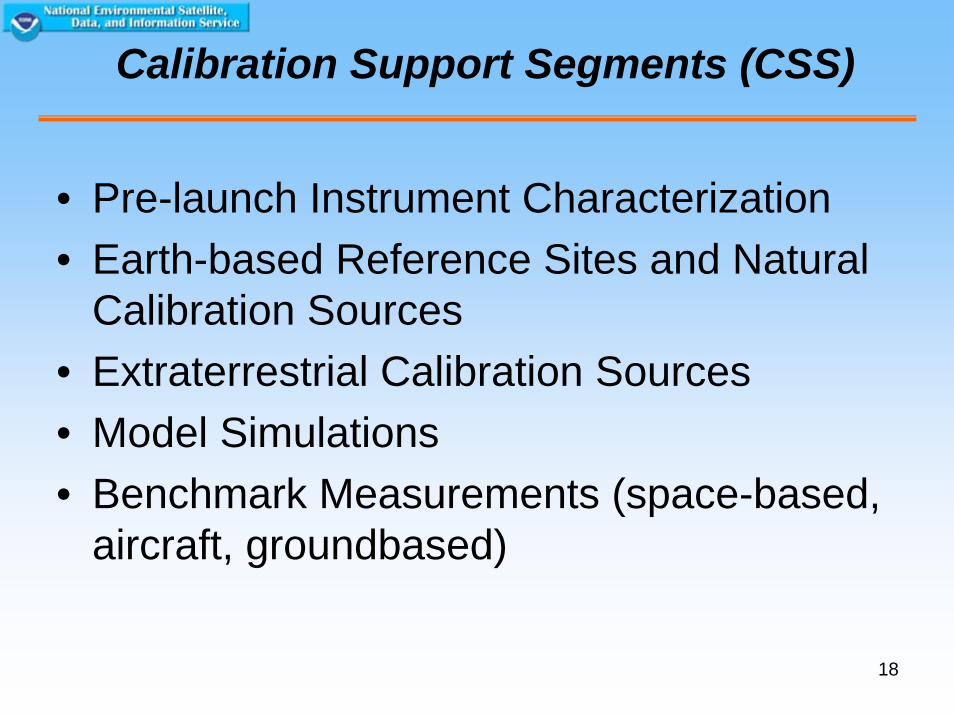
Calibration Support Segments (CSS)
• Pre-launch Instrument Characterization• Earth-based Reference Sites and Natural
Calibration Sources• Extraterrestrial Calibration Sources• Model Simulations• Benchmark Measurements (space-based,
aircraft, groundbased)
19
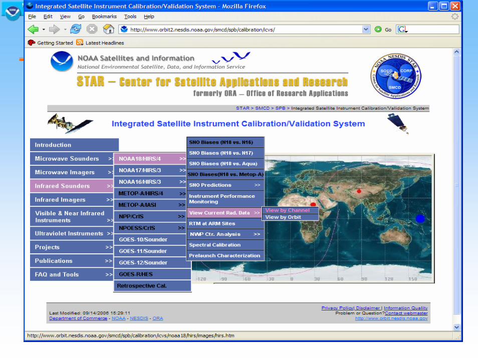
Web Interface to the Integrated Cal/Val System
20
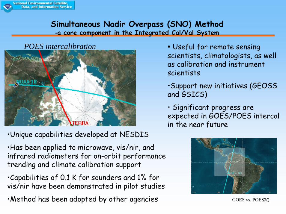
Simultaneous Nadir Overpass (SNO) Method-a core component in the Integrated Cal/Val System
GOES vs. POES
POES intercalibration
•Unique capabilities developed at NESDIS
•Has been applied to microwave, vis/nir, and infrared radiometers for on-orbit performance trending and climate calibration support
•Capabilities of 0.1 K for sounders and 1% for vis/nir have been demonstrated in pilot studies
•Method has been adopted by other agencies
• Useful for remote sensing scientists, climatologists, as well as calibration and instrument scientists
•Support new initiatives (GEOSS and GSICS)
• Significant progress are expected in GOES/POES intercalin the near future
21
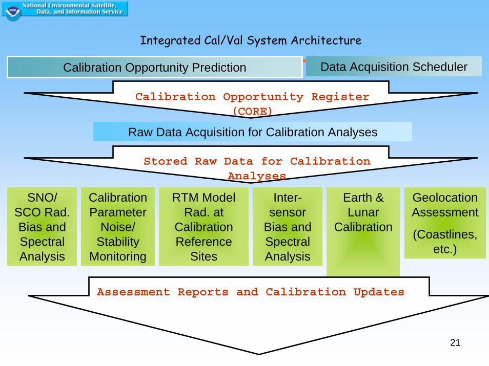
Calibration Opportunity Prediction
SNO/SCO Rad. Bias and Spectral Analysis
Earth & Lunar
Calibration
Calibration Parameter
Noise/Stability
Monitoring
RTM Model Rad. at
Calibration Reference
Sites
Inter-sensor
Bias and Spectral Analysis
GeolocationAssessment
(Coastlines, etc.)
Assessment Reports and Calibration Updates
Calibration Opportunity Register(CORE)
Integrated Cal/Val System Architecture
Data Acquisition Scheduler
Raw Data Acquisition for Calibration Analyses
Stored Raw Data for CalibrationAnalyses
22
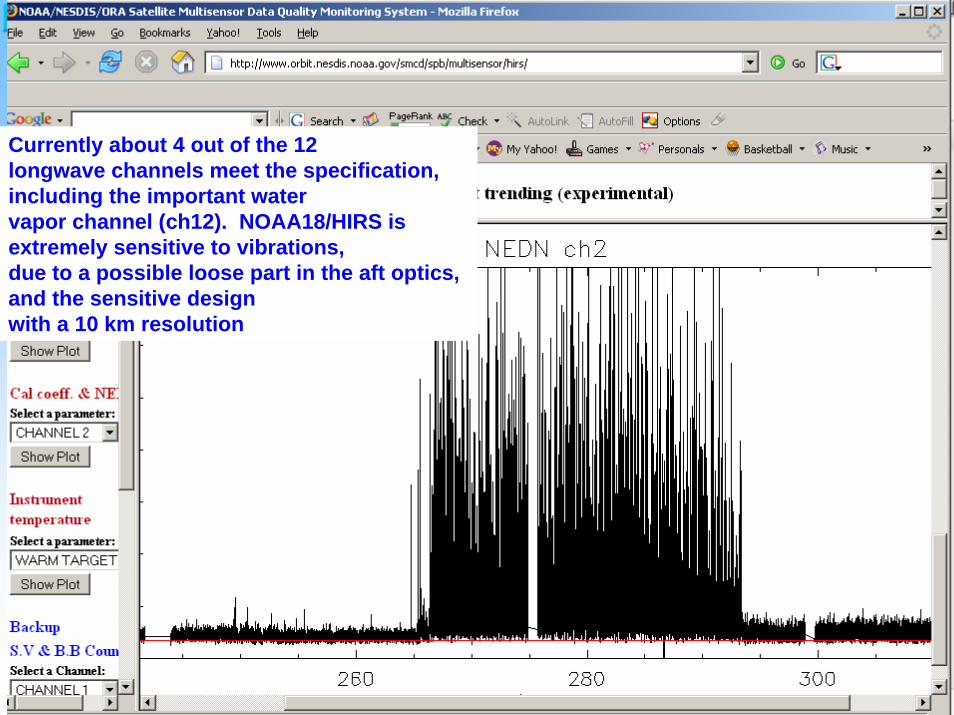
Currently about 4 out of the 12longwave channels meet the specification, including the important watervapor channel (ch12). NOAA18/HIRS is extremely sensitive to vibrations,due to a possible loose part in the aft optics, and the sensitive designwith a 10 km resolution
23
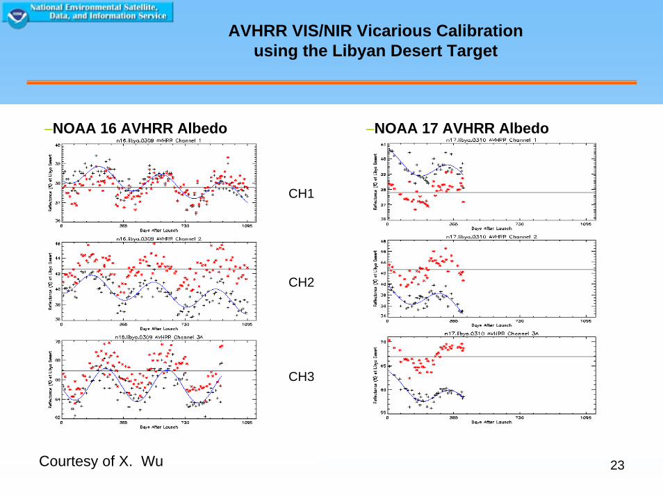
AVHRR VIS/NIR Vicarious Calibrationusing the Libyan Desert Target
Courtesy of X. Wu
–NOAA 16 AVHRR Albedo –NOAA 17 AVHRR Albedo
CH1
CH2
CH3
24
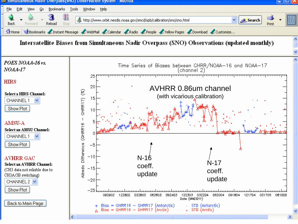
N-17 coeff. update
N-16 coeff. update
AVHRR 0.86um channel (with vicarious calibration)
25
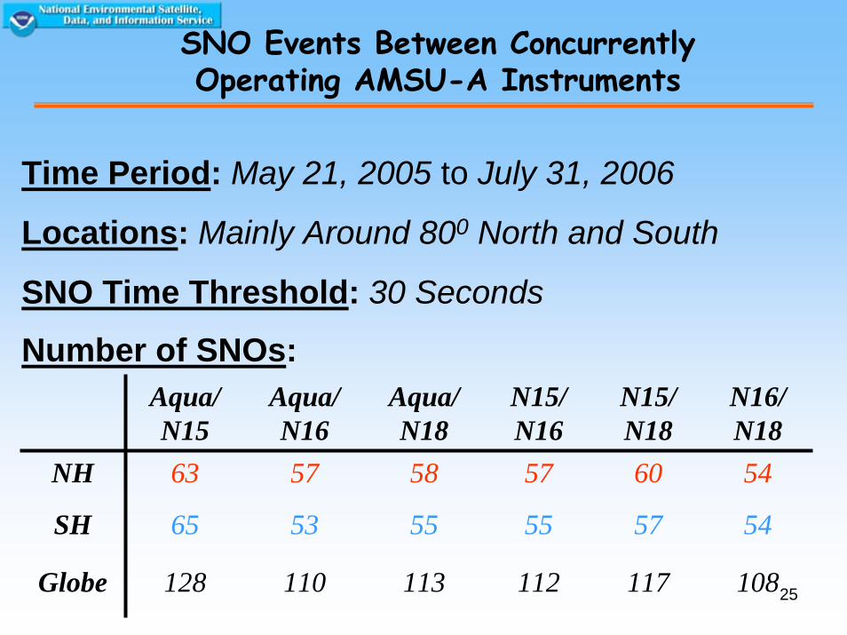
Time Period: May 21, 2005 to July 31, 2006
Locations: Mainly Around 800 North and South
SNO Time Threshold: 30 Seconds
SNO Events Between Concurrently Operating AMSU-A Instruments
Number of SNOs:Aqua/ N15
Aqua/ N16
Aqua/ N18
N15/ N16
N15/ N18
N16/ N18
NH 63 57 58 57 60 54
SH 65 53 55 55 57 54
Globe 128 110 113 112 117 108
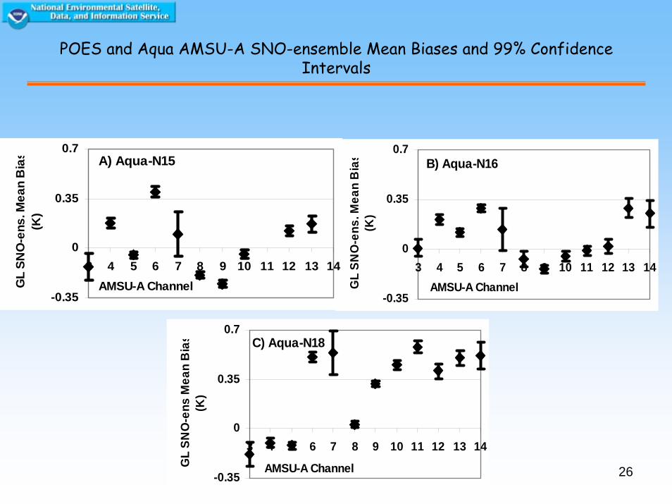
26-0.35
0
0.35
0.7
3 4 5 6 7 8 9 10 11 12 13 14
AMSU-A ChannelGL
SNO
-ens
Mea
n B
ias
(K)
C) Aqua-N18
-0.35
0
0.35
0.7
3 4 5 6 7 8 9 10 11 12 13 14AMSU-A ChannelG
L SN
O-e
ns. M
ean
Bia
s(K
)
B) Aqua-N16
POES and Aqua AMSU-A SNO-ensemble Mean Biases and 99% Confidence Intervals
-0.35
0
0.35
0.7
3 4 5 6 7 8 9 10 11 12 13 14AMSU-A ChannelG
L SN
O-e
ns. M
ean
Bia
s(K
)
A) Aqua-N15
27
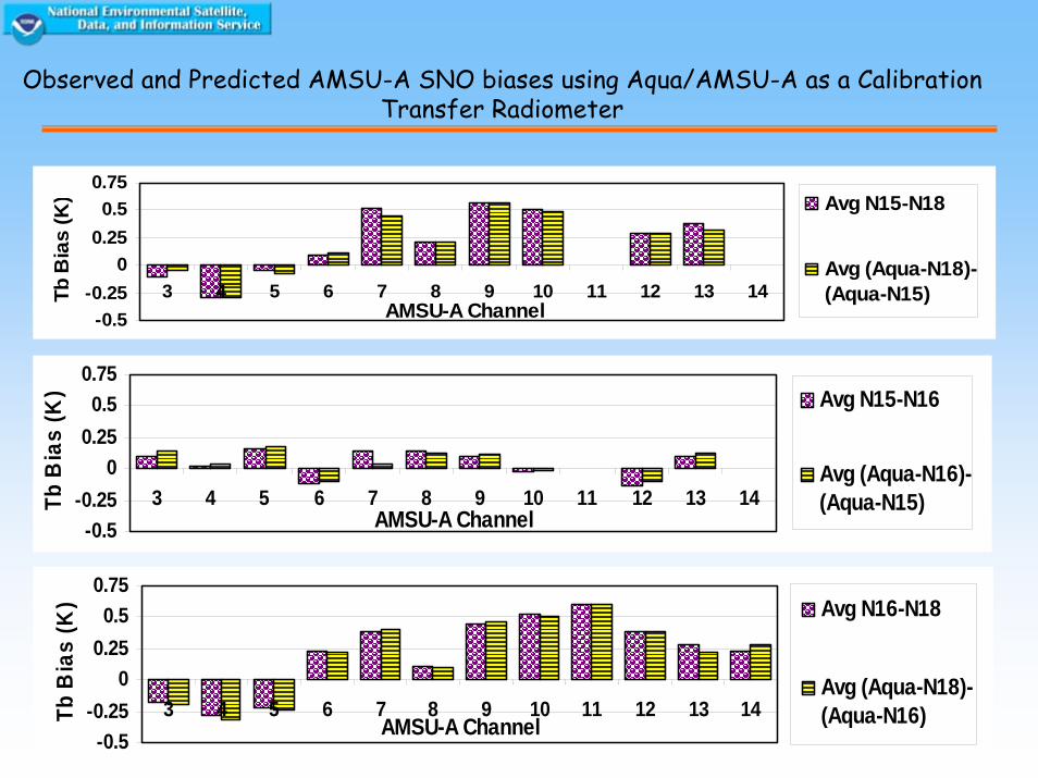
-0.5-0.25
00.250.5
0.75
3 4 5 6 7 8 9 10 11 12 13 14AMSU-A Channel
Tb B
ias
(K) Avg N15-N18
Avg (Aqua-N18)-(Aqua-N15)
-0.5-0.25
00.250.5
0.75
3 4 5 6 7 8 9 10 11 12 13 14AMSU-A ChannelTb
Bia
s (K
) Avg N16-N18
Avg (Aqua-N18)-(Aqua-N16)
-0.5-0.25
00.250.5
0.75
3 4 5 6 7 8 9 10 11 12 13 14AMSU-A Channel
Tb B
ias
(K) Avg N15-N16
Avg (Aqua-N16)-(Aqua-N15)
Observed and Predicted AMSU-A SNO biases using Aqua/AMSU-A as a Calibration Transfer Radiometer
28
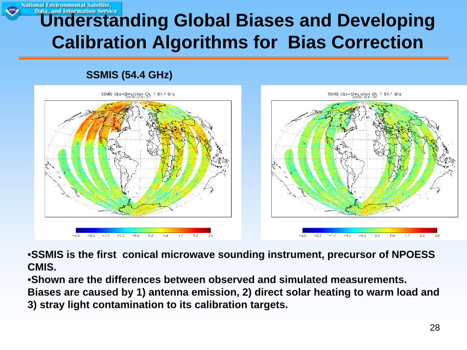
Understanding Global Biases and Developing Calibration Algorithms for Bias Correction
•SSMIS is the first conical microwave sounding instrument, precursor of NPOESS CMIS.•Shown are the differences between observed and simulated measurements. Biases are caused by 1) antenna emission, 2) direct solar heating to warm load and 3) stray light contamination to its calibration targets.
SSMIS (54.4 GHz)
29
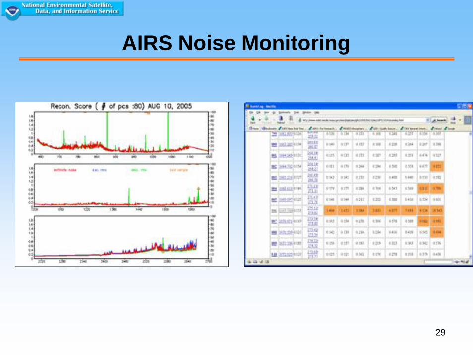
AIRS Noise Monitoring
30
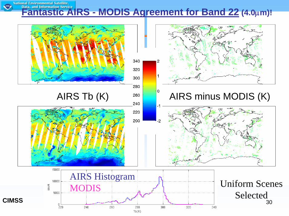
AIRS Tb (K) AIRS minus MODIS (K)
Fantastic AIRS - MODIS Agreement for Band 22 (4.0μm)!
AIRS HistogramMODIS Uniform Scenes
SelectedCIMSS
31
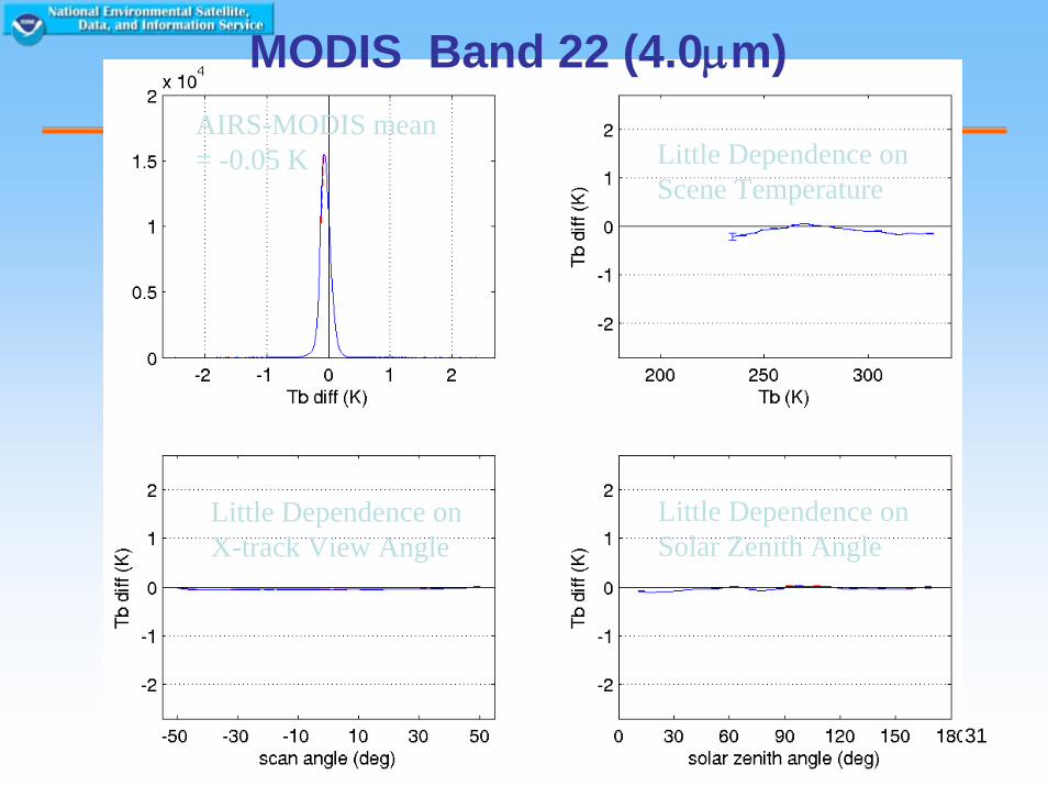
MODIS Band 22 (4.0μm)AIRS-MODIS mean = -0.05 K Little Dependence on
Scene Temperature
Little Dependence onX-track View Angle
Little Dependence onSolar Zenith Angle
32
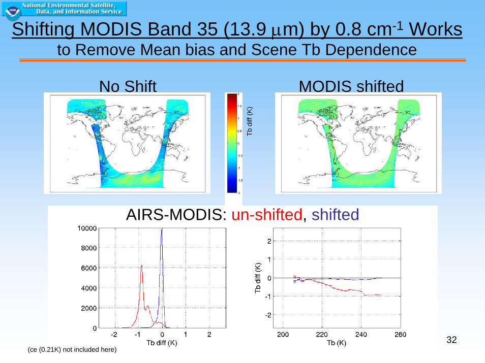
No Shift MODIS shifted
Tb d
iff (K
)
AIRS-MODIS: un-shifted, shifted
Shifting MODIS Band 35 (13.9 μm) by 0.8 cm-1 Worksto Remove Mean bias and Scene Tb Dependence
(ce (0.21K) not included here)
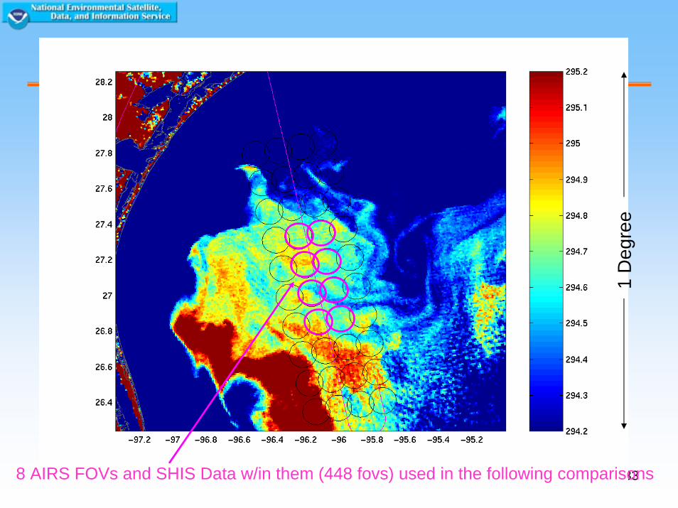
338 AIRS FOVs and SHIS Data w/in them (448 fovs) used in the following comparisons
1 D
egre
e
34
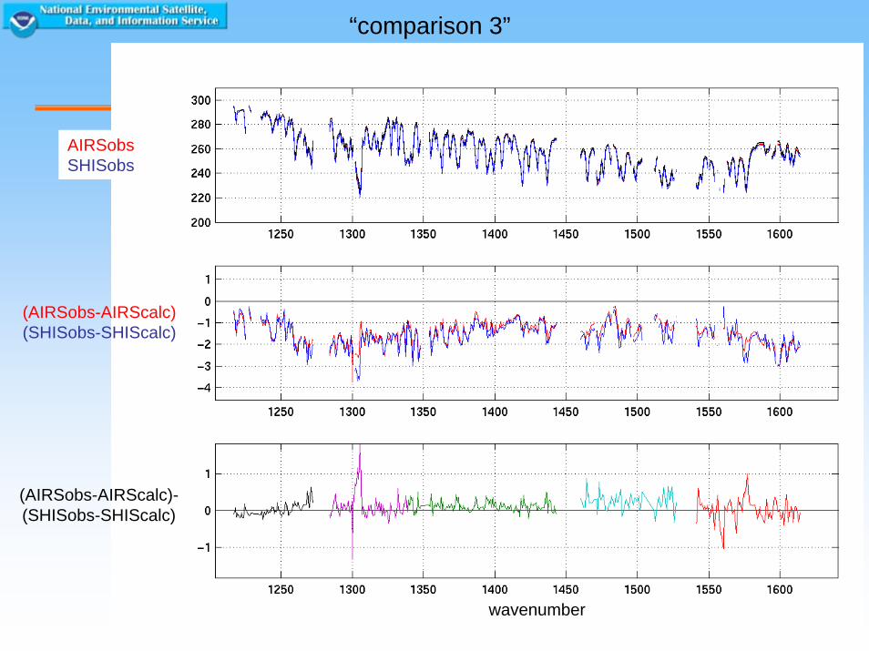
“comparison 3”
(AIRSobs-AIRScalc)(SHISobs-SHIScalc)
AIRSobsSHISobs
(AIRSobs-AIRScalc)-(SHISobs-SHIScalc)
wavenumber
35
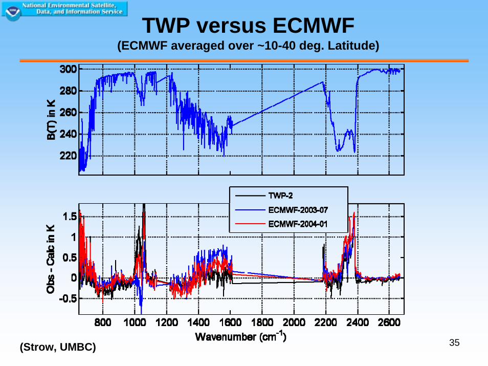
TWP versus ECMWF(ECMWF averaged over ~10-40 deg. Latitude)
(Strow, UMBC)
36
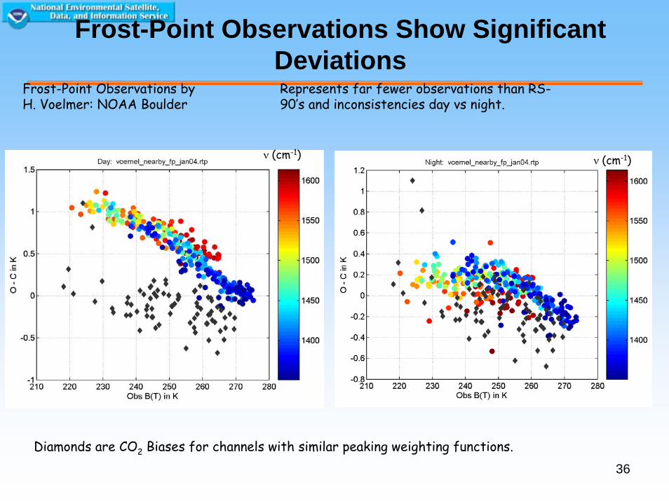
Frost-Point Observations Show Significant Deviations
Diamonds are CO2 Biases for channels with similar peaking weighting functions.
Frost-Point Observations by H. Voelmer: NOAA Boulder
Represents far fewer observations than RS-90’s and inconsistencies day vs night.
ν (cm-1) ν (cm-1)
37
Summary
• GSICS - coordinated effort to better characterise and improve the fundamental measurements of the Global Observing System
• Improve radiance quality >>>reduce uncertainties in forecasts and climate data records
38
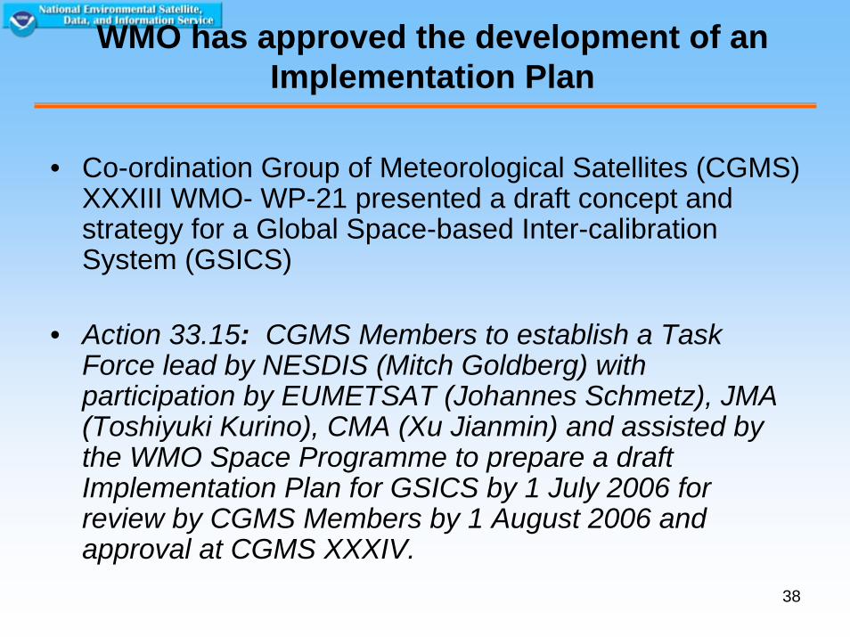
WMO has approved the development of an Implementation Plan
• Co-ordination Group of Meteorological Satellites (CGMS) XXXIII WMO- WP-21 presented a draft concept and strategy for a Global Space-based Inter-calibration System (GSICS)
• Action 33.15: CGMS Members to establish a Task Force lead by NESDIS (Mitch Goldberg) with participation by EUMETSAT (Johannes Schmetz), JMA (Toshiyuki Kurino), CMA (Xu Jianmin) and assisted by the WMO Space Programme to prepare a draft Implementation Plan for GSICS by 1 July 2006 for review by CGMS Members by 1 August 2006 and approval at CGMS XXXIV.
39
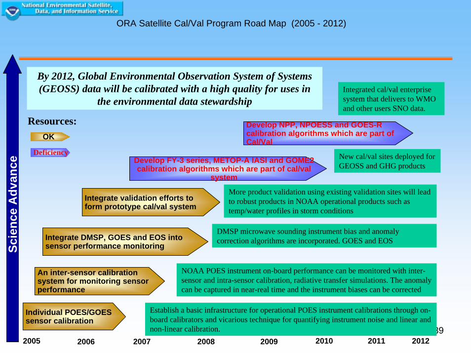
ORA Satellite Cal/Val Program Road Map (2005 - 2012)
Integrate DMSP, GOES and EOS into sensor performance monitoring
2005 2007 2009 2010 2011 20082006
Develop FY-3 series, METOP-A IASI and GOME2 calibration algorithms which are part of cal/val
system
Scie
nce
Adv
ance
By 2012, Global Environmental Observation System of Systems (GEOSS) data will be calibrated with a high quality for uses in
the environmental data stewardship
2012
An inter-sensor calibration system for monitoring sensor performance
Integrate validation efforts to form prototype cal/val system
Individual POES/GOES sensor calibration
Establish a basic infrastructure for operational POES instrument calibrations through on-board calibrators and vicarious technique for quantifying instrument noise and linear and non-linear calibration.
NOAA POES instrument on-board performance can be monitored with inter-sensor and intra-sensor calibration, radiative transfer simulations. The anomaly can be captured in near-real time and the instrument biases can be corrected
DMSP microwave sounding instrument bias and anomaly correction algorithms are incorporated. GOES and EOS
More product validation using existing validation sites will lead to robust products in NOAA operational products such as temp/water profiles in storm conditions
Develop NPP, NPOESS and GOES-R calibration algorithms which are part of Cal/Val
New cal/val sites deployed for GEOSS and GHG products
Integrated cal/val enterprise system that delivers to WMO and other users SNO data.
OK
Deficiency
Resources:
40
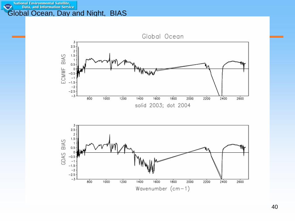
Global Ocean, Day and Night, BIAS