Embed Size (px)
Citation preview
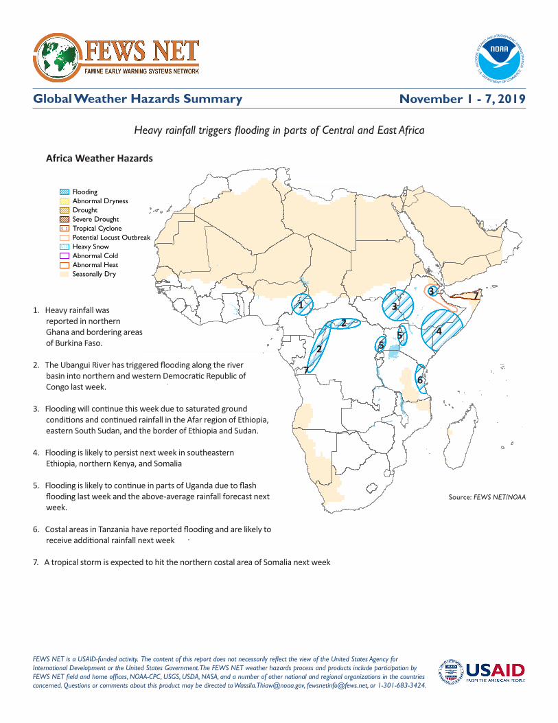
Global Weather Hazards Summary
Africa Weather Hazards
FEWS NET is a USAID-funded activity. The content of this report does not necessarily reflect the view of the United States Agency for International Development or the United States Government. The FEWS NET weather hazards process and products include participation by FEWS NET field and home offices, NOAA-CPC, USGS, USDA, NASA, and a number of other national and regional organizations in the countries concerned. Questions or comments about this product may be directed to [email protected], [email protected], or 1-301-683-3424.
Source: FEWS NET/NOAA
FloodingAbnormal DrynessDroughtSevere DroughtTropical CyclonePotential Locust OutbreakHeavy SnowAbnormal ColdAbnormal HeatSeasonally Dry
November 1 - 7, 2019
Heavy rainfall triggers flooding in parts of Central and East Africa
1. Heavy rainfall was reported in northern Ghana and bordering areas of Burkina Faso.
2. The Ubangui River has triggered flooding along the river basin into northern and western Democratic Republic of Congo last week.
3. Flooding will continue this week due to saturated ground conditions and continued rainfall in the Afar region of Ethiopia, eastern South Sudan, and the border of Ethiopia and Sudan.
4. Flooding is likely to persist next week in southeastern Ethiopia, northern Kenya, and Somalia
5. Flooding is likely to continue in parts of Uganda due to flash flooding last week and the above-average rainfall forecast next week.
6. Costal areas in Tanzania have reported flooding and are likely to receive additional rainfall next week
7. A tropical storm is expected to hit the northern costal area of Somalia next week
1
2
4
3
55
67
2
73

Famine Early Warning Systems Network 2
Weather Hazards Summary
Africa Overview
Swarms of locust move across northeastern EthiopiaA locust warning has been issued in northeastern Ethiopia following the summer mating season and the displacement of mature grasshoppers to the Afar and Dire Dawa regions. The Tropical cyclone developing in the Arabian Sea is likely to weaken significantly by the end of the week and will reach the Horn of Africa. Southern Mauritania has experienced rapid moisture recovery, and eastern Sudan has received above-normal rainfall (Figure 1). The rainy season in West Africa is nearing its end, as a new rainfall season is about to begin in Southern Africa. Last week, light to moderate amounts of rainfall were registered in Nigeria and several countries in central Africa, with heavier amounts of rainfall recorded in Cote d’Ivoire, Ghana, and the far western and southern areas of Ethiopia, Uganda, Kenya, and Tanzania.
During the last 30-days, Yemen, northern Somalia, and border areas of Ethiopia have received above-average rainfall (Figure 2). Meanwhile, strong rainfall deficits are observed in the eastern Democratic Republic of Congo and the coastal areas of Cameroon, Equatorial Guinea, and southern Gabon.
Next week, heavy rainfall is forecast over the southern borders of Nigeria and Cameroon, Gabon, and the Democratic Republic of Congo. Near-average rainfall is expected over the Juba and Shabelle regions and northern Somalia.
Tropical cyclone Kyarr is likely to make landfall on the northern coast of SomaliaLast week, Angola, northern Zambia, and eastern parts of South Africa, Swaziland, Botswana, and Madagascar registered light rainfall (Figure 1). During the past 30-days, significant rainfall deficits have developed in eastern South Africa and central Angola (Figure 2). High temperatures have been recorded over Mozambique, Zimbabwe, northern South Africa, Swaziland, Lesotho, and southern Madagascar. Next week, temperatures will be between 8-12 °C which may strengthen and/or maintain abnormal dryness in the region.
Next week, slightly above-normal amounts of rainfall are likely over eastern South Africa, Lesotho, Swaziland, and southern Botswana, while near average rainfall is forecast in central and northern Angola. Below-average amounts of rainfall and high temperatures are expected in southern Angola, Zambia, southern Tanzania, northern Mozambique, and Zimbabwe.
November 1 - 7, 2019
Source: NOAA/CPC
Source: NOAA/CPC
Figure 1: ARC 30-Day Total Rainfall Anomaly (mm)Valid: September 30 - October 29, 2019
Figure 1: RFE 7-Day Total Rainfall (mm)Valid: October 23 - 29, 2019
Famine Early Warning Systems Network 3
Weather Hazards Summary
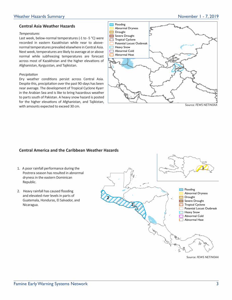
Central Asia Weather Hazards
Central America and the Caribbean Weather Hazards
Source: FEWS NET/NOAA
FloodingAbnormal DrynessDroughtSevere DroughtTropical CyclonePotential Locust OutbreakHeavy SnowAbnormal ColdAbnormal Heat
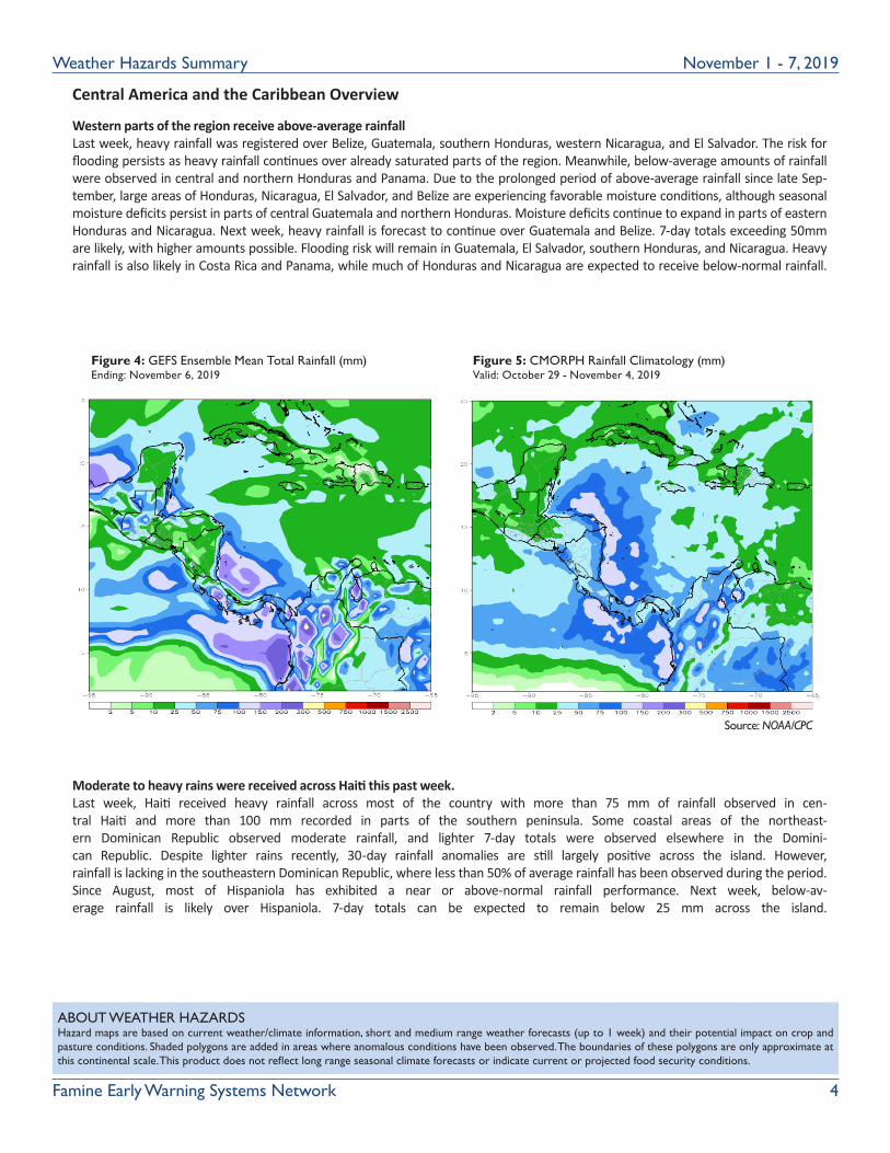
1. A poor rainfall performance during the Postrera season has resulted in abnormal dryness in the eastern Dominican Republic.
2. Heavy rainfall has caused flooding and elevated river levels in parts of Guatemala, Honduras, El Salvador, and Nicaragua.
Source: FEWS NET/NOAA
FloodingAbnormal DrynessDroughtSevere DroughtTropical CyclonePotential Locust OutbreakHeavy SnowAbnormal ColdAbnormal Heat
November 1 - 7, 2019
Temperatures Last week, below-normal temperatures (-1 to -5 °C) were recorded in eastern Kazakhstan while near to above-normal temperatures prevailed elsewhere in Central Asia. Next week, temperatures are likely to average at or above normal while subfreezing temperatures are forecast across most of Kazakhstan and the higher elevations of Afghanistan, Kyrgyzstan, and Tajikistan.
PrecipitationDry weather conditions persist across Central Asia. Despite this, precipitation over the past 90-days has been near average. The development of Tropical Cyclone Kyarr in the Arabian Sea and is like to bring hazardous weather to parts south of Pakistan. A heavy snow hazard is posted for the higher elevations of Afghanistan, and Tajikistan, with amounts expected to exceed 30 cm.
1
22
Famine Early Warning Systems Network 4
Weather Hazards Summary
Central America and the Caribbean Overview
Western parts of the region receive above-average rainfall Last week, heavy rainfall was registered over Belize, Guatemala, southern Honduras, western Nicaragua, and El Salvador. The risk for flooding persists as heavy rainfall continues over already saturated parts of the region. Meanwhile, below-average amounts of rainfall were observed in central and northern Honduras and Panama. Due to the prolonged period of above-average rainfall since late Sep-tember, large areas of Honduras, Nicaragua, El Salvador, and Belize are experiencing favorable moisture conditions, although seasonal moisture deficits persist in parts of central Guatemala and northern Honduras. Moisture deficits continue to expand in parts of eastern Honduras and Nicaragua. Next week, heavy rainfall is forecast to continue over Guatemala and Belize. 7-day totals exceeding 50mm are likely, with higher amounts possible. Flooding risk will remain in Guatemala, El Salvador, southern Honduras, and Nicaragua. Heavy rainfall is also likely in Costa Rica and Panama, while much of Honduras and Nicaragua are expected to receive below-normal rainfall.
Moderate to heavy rains were received across Haiti this past week.Last week, Haiti received heavy rainfall across most of the country with more than 75 mm of rainfall observed in cen-tral Haiti and more than 100 mm recorded in parts of the southern peninsula. Some coastal areas of the northeast-ern Dominican Republic observed moderate rainfall, and lighter 7-day totals were observed elsewhere in the Domini-can Republic. Despite lighter rains recently, 30-day rainfall anomalies are still largely positive across the island. However, rainfall is lacking in the southeastern Dominican Republic, where less than 50% of average rainfall has been observed during the period. Since August, most of Hispaniola has exhibited a near or above-normal rainfall performance. Next week, below-av-erage rainfall is likely over Hispaniola. 7-day totals can be expected to remain below 25 mm across the island.
Source: NOAA/CPC
ABOUT WEATHER HAZARDSHazard maps are based on current weather/climate information, short and medium range weather forecasts (up to 1 week) and their potential impact on crop and pasture conditions. Shaded polygons are added in areas where anomalous conditions have been observed. The boundaries of these polygons are only approximate at this continental scale. This product does not reflect long range seasonal climate forecasts or indicate current or projected food security conditions.
November 1 - 7, 2019
Source: NOAA/CPC
Figure 4: GEFS Ensemble Mean Total Rainfall (mm)Ending: November 6, 2019
Figure 5: CMORPH Rainfall Climatology (mm) Valid: October 29 - November 4, 2019