Embed Size (px)
Citation preview
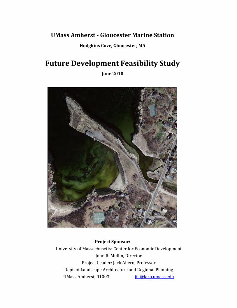
UMassAmherstGloucesterMarineStationHodgkinsCove,Gloucester,MA
FutureDevelopmentFeasibilityStudyJune2010
ProjectSponsor:
UniversityofMassachusetts:CenterforEconomicDevelopment JohnR.Mullin,Director
ProjectLeader:JackAhern,Professor Dept.ofLandscapeArchitectureandRegionalPlanning UMassAmherst,01003 [email protected]
2
UMassAmherstGloucesterMarineStation
HodgkinsCove,Gloucester,MA
FutureDevelopmentFeasibilityStudy
CenterforEconomicDevelopmentDepartmentofLandscapeArchitectureandRegionalPlanning
UniversityofMassachusettsAmherstJohnR.Mullin,Ph.D.,Director
JackAhern,Ph.D.,ProjectLeader
June2010
3
UMassAmherstGloucesterMarineStationHodgkinsCove,Gloucester,MA
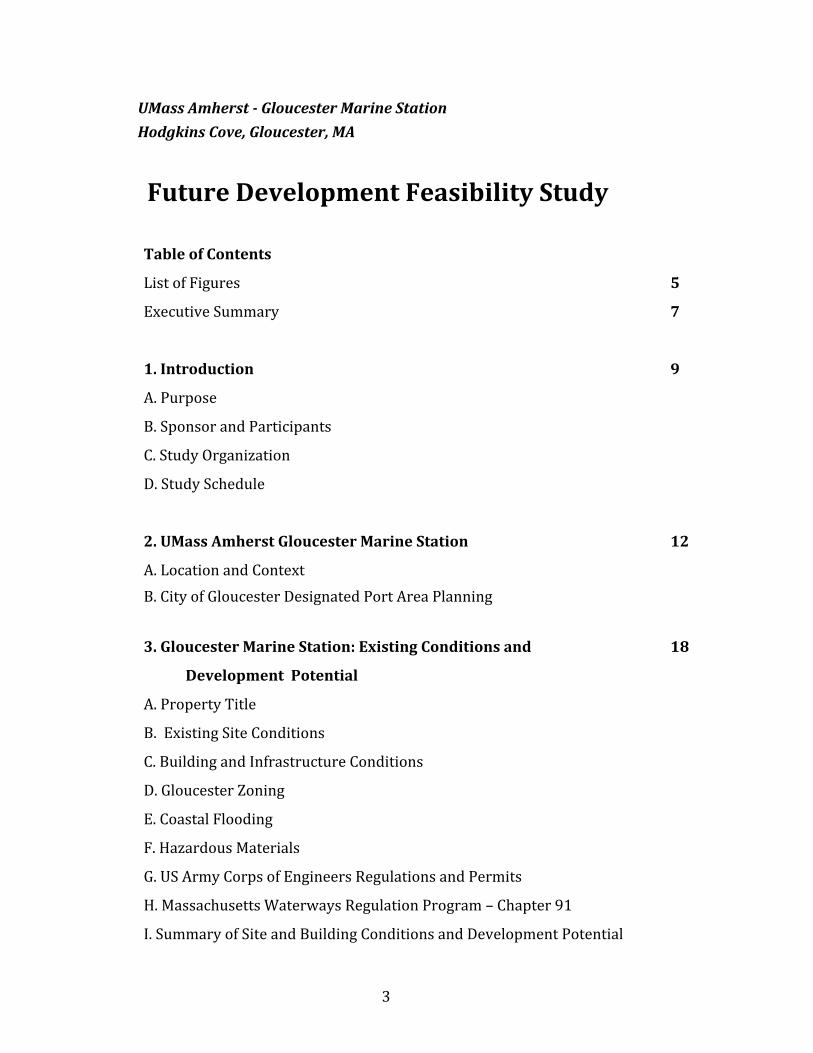
FutureDevelopmentFeasibilityStudyTableofContents
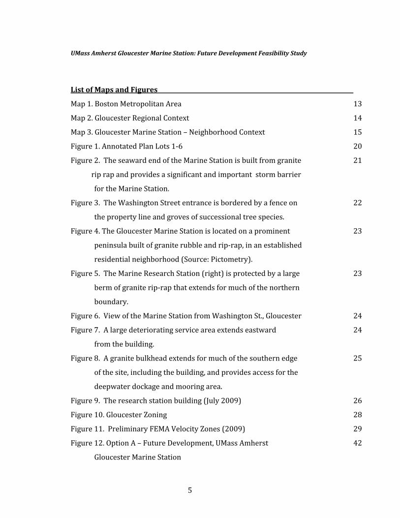
ListofFigures 5
ExecutiveSummary 7
1.Introduction 9
A.Purpose
B.SponsorandParticipants
C.StudyOrganization
D.StudySchedule
2.UMassAmherstGloucesterMarineStation 12
A.LocationandContextB.CityofGloucesterDesignatedPortAreaPlanning3.GloucesterMarineStation:ExistingConditionsand 18
DevelopmentPotential
A.PropertyTitle
B.ExistingSiteConditions
C.BuildingandInfrastructureConditions
D.GloucesterZoning
E.CoastalFlooding
F.HazardousMaterials
G.USArmyCorpsofEngineersRegulationsandPermits
H.MassachusettsWaterwaysRegulationProgram–Chapter91
I.SummaryofSiteandBuildingConditionsandDevelopmentPotential
4
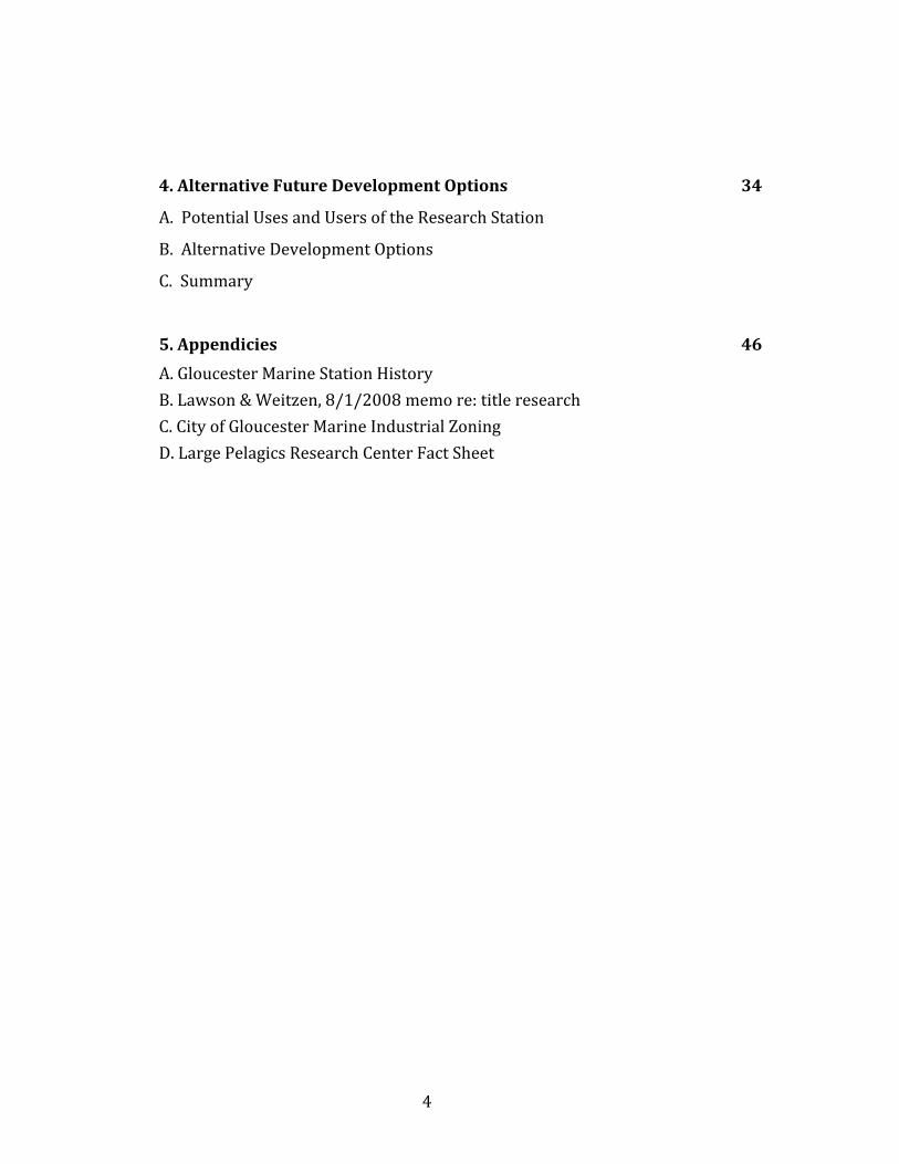
4.AlternativeFutureDevelopmentOptions 34
A.PotentialUsesandUsersoftheResearchStation
B.AlternativeDevelopmentOptions
C.Summary
5.Appendicies 46
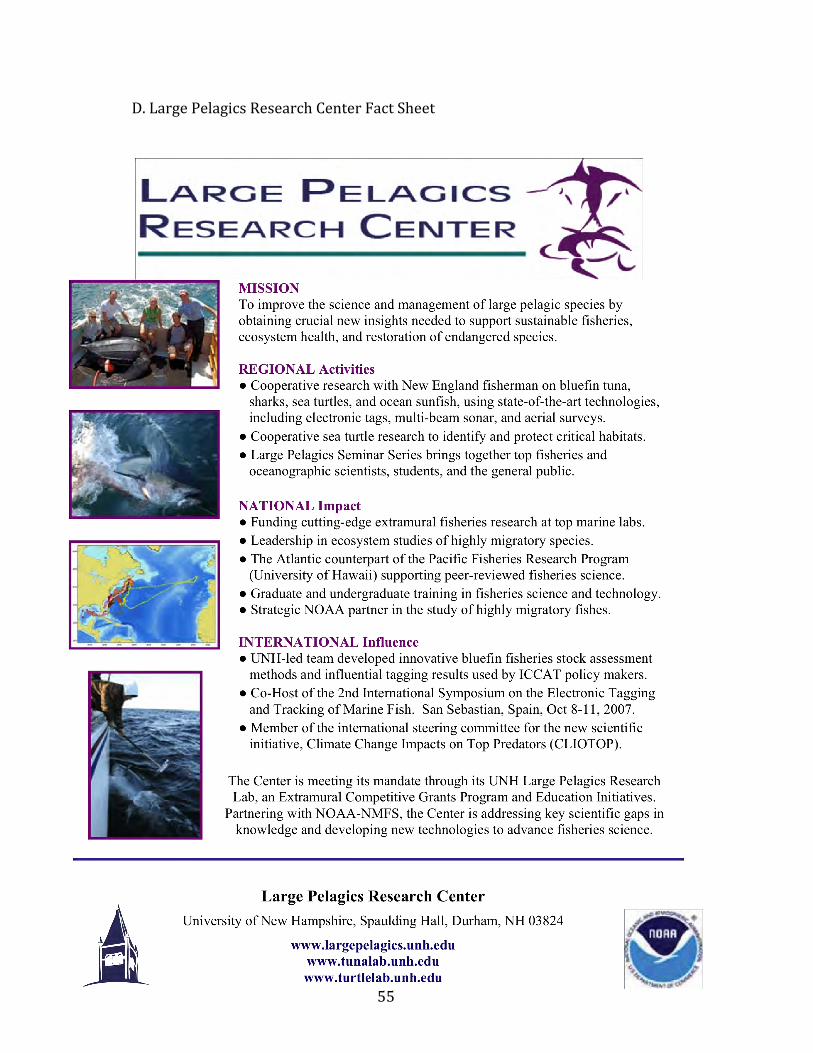
A.GloucesterMarineStationHistoryB.Lawson&Weitzen,8/1/2008memore:titleresearchC.CityofGloucesterMarineIndustrialZoningD.LargePelagicsResearchCenterFactSheet
5
UMassAmherstGloucesterMarineStation:FutureDevelopmentFeasibilityStudy
ListofMapsandFigures
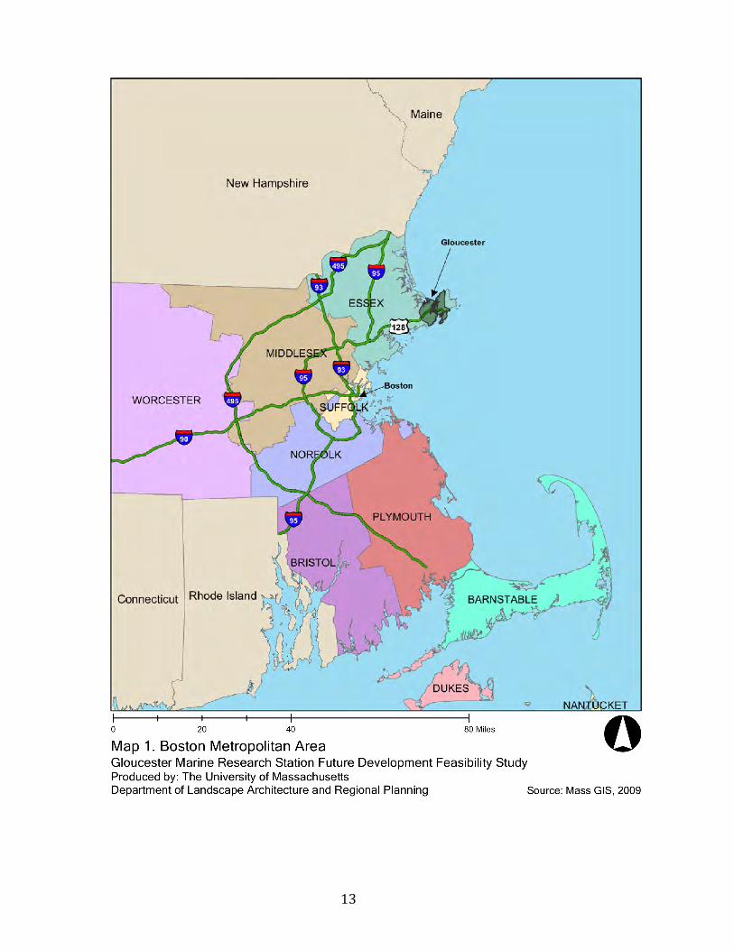
Map1.BostonMetropolitanArea 13
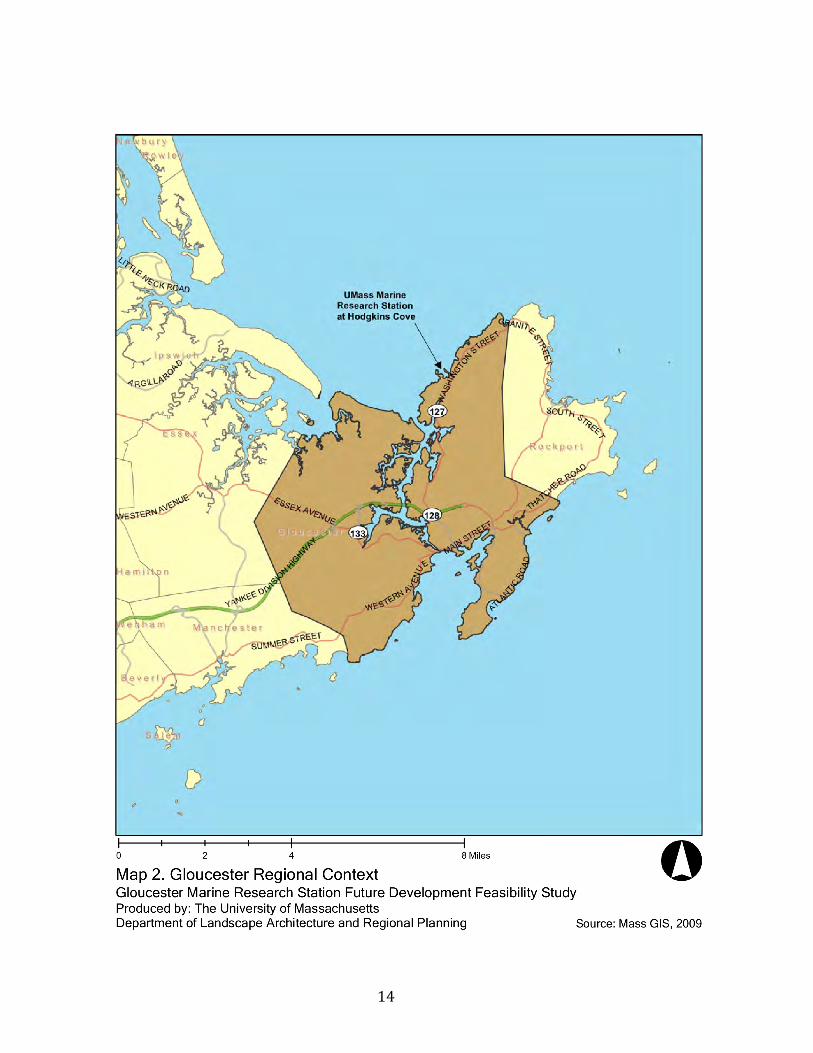
Map2.GloucesterRegionalContext 14
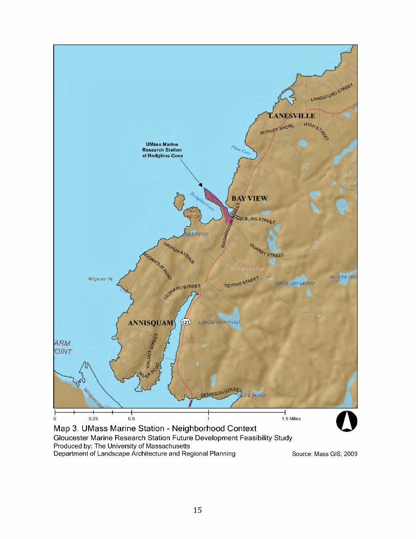
Map3.GloucesterMarineStation–NeighborhoodContext 15
Figure1.AnnotatedPlanLots1‐6 20
Figure2.TheseawardendoftheMarineStationisbuiltfromgranite 21
riprapandprovidesasignificantandimportantstormbarrier
fortheMarineStation.
Figure3.TheWashingtonStreetentranceisborderedbyafenceon 22
thepropertylineandgrovesofsuccessionaltreespecies.
Figure4.TheGloucesterMarineStationislocatedonaprominent 23
peninsulabuiltofgraniterubbleandrip‐rap,inanestablished
residentialneighborhood(Source:Pictometry).
Figure5.TheMarineResearchStation(right)isprotectedbyalarge 23
bermofgraniterip‐rapthatextendsformuchofthenorthern
boundary.
Figure6.ViewoftheMarineStationfromWashingtonSt.,Gloucester 24
Figure7.Alargedeterioratingserviceareaextendseastward 24
fromthebuilding.
Figure8.Agranitebulkheadextendsformuchofthesouthernedge 25
ofthesite,includingthebuilding,andprovidesaccessforthe
deepwaterdockageandmooringarea.
Figure9.Theresearchstationbuilding(July2009) 26
Figure10.GloucesterZoning 28
Figure11.PreliminaryFEMAVelocityZones(2009) 29
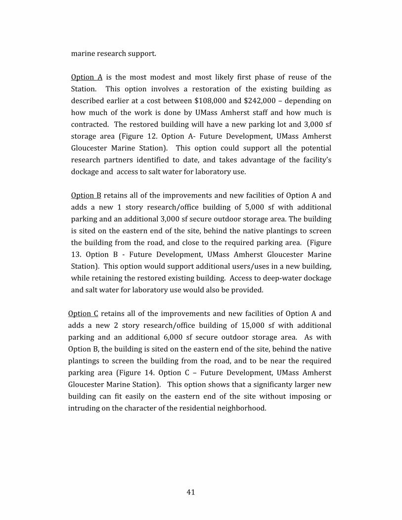
Figure12.OptionA–FutureDevelopment,UMassAmherst 42
GloucesterMarineStation
6
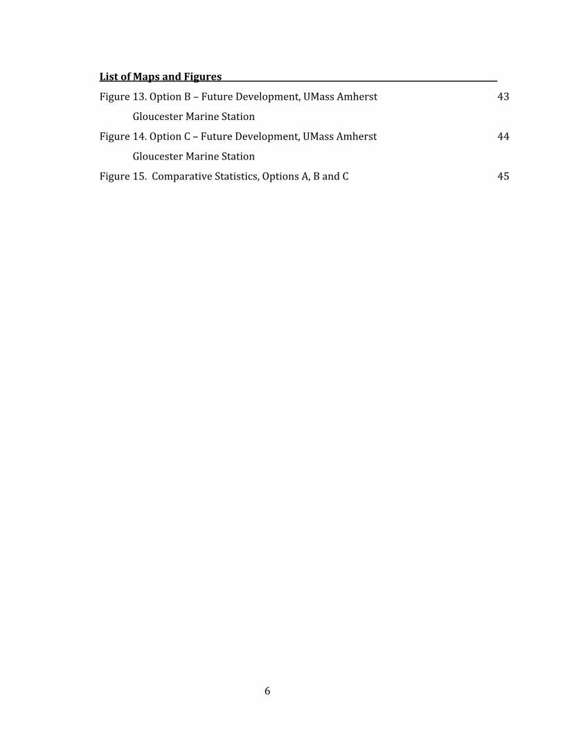
ListofMapsandFigures
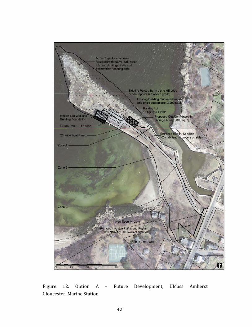
Figure13.OptionB–FutureDevelopment,UMassAmherst 43
GloucesterMarineStation
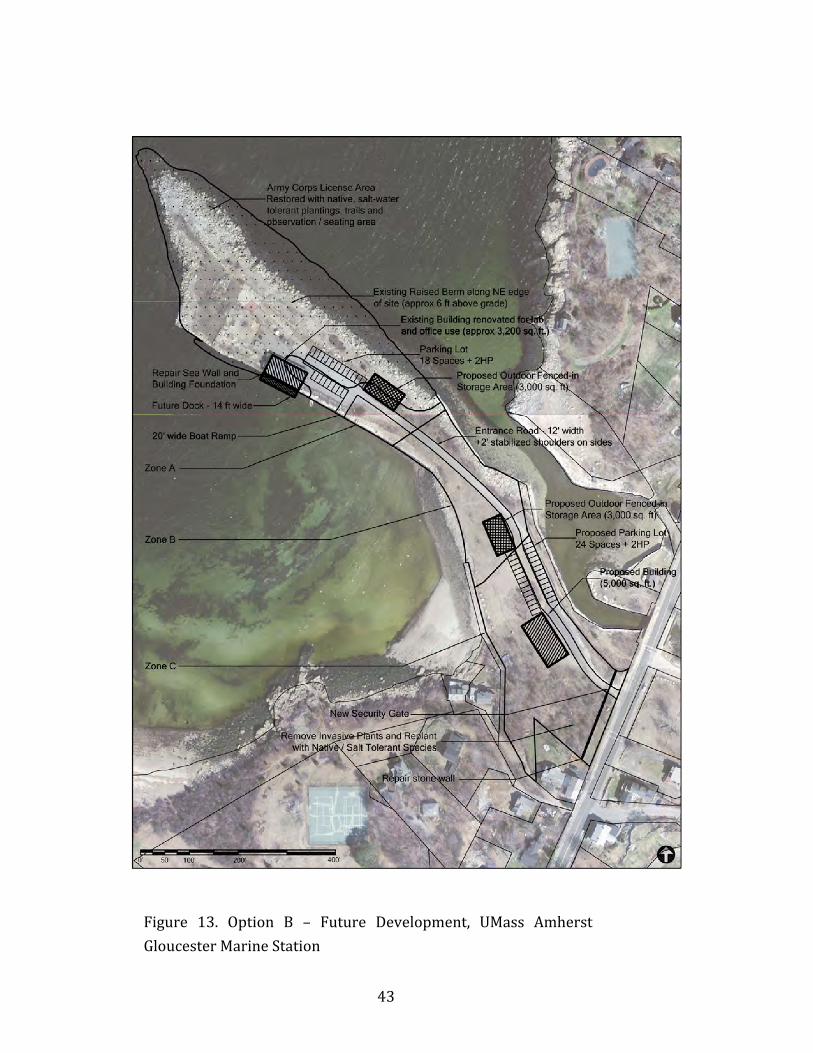
Figure14.OptionC–FutureDevelopment,UMassAmherst 44
GloucesterMarineStation
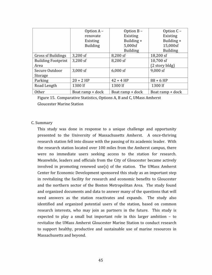
Figure15.ComparativeStatistics,OptionsA,BandC 45
7
UMassAmherstGloucesterMarineStation:FutureDevelopmentFeasibilityStudy
ExecutiveSummary
TheUMassAmherstGloucesterMarineStation (GMS) isavaluablepropertywith direct ocean access and a well‐respected research history in foodmicrobiology.WiththepassingofUMassresearchprofessorHerbertHultinin2007,thestationfell intodisuseanddecline. Inrecentyears,theUniversityfacilityhasbeenclosed–pendingdecisionsconcerningfutureuse.Recently,MassachusettsStateSenatorBruceTarr,GloucesterofficialsandothershaveurgedtheUniversitytoactivelyassessthepropertyincludingthefeasibilityofappropriate future uses and potential collaborators to generate a renewedandproductivefutureuseoftheproperty.This feasibilitystudy(July2009‐June2010)wasfundedbytheUniversityofMassachusettsAmherst’sCenterforEconomicDevelopment,directedbyJohnR.Mullin. The study aimed to assess the feasibility of alternative research‐oriented future uses to actively use this UMass Amherst property and tostimulate local employment and economic activity in Gloucester and EssexCounty.Thestudyinvolvedfieldvisits,meetingswithnumerousofficialsandpublic hearings to solicit information and to identify potential interest infutureuse,andpotentialusersoftheGloucesterMarineStation.Thestudyfoundsomeuncertaintyregardingthepropertytitle,toberesolvedthroughfuturelegalresearch,orpossiblyinlandcourt.Approximatelyhalfofthe property is unbuildable (the seaward end), under conditions of a U.S.ArmyCorpsofEngineers(ACE)license.ArecentcoastalfloodmapbytheU.S.FederalOfficeofEmergencyManagement(FEMA)showsmostofthepropertyis located above the “velocity zone”, allowing for conventional construction.Approximatelyhalfofthesiteisbuildable,withnosignificant limitationsforanticipatedresearch‐focuseduses.TheCityofGloucesterissupportiveofre‐activatingresearchuse(s)atthestation.
8
Through public and UMass‐system workshops and meetings, a number ofpotential collaborators have been identified, including: University ofMassachusetts Amherst and Boston, Salem State College, MassachusettsInstituteofTechnology,MassachusettsDivisionofMarineFisheries,andNewEngland Biolabs. The University of Massachusetts Amherst is planning torenovate the Station for a Large Pelagics Research Center, funded by theNational Science Foundation (NSF), thatwill be relocated to the GloucesterMarineStation.InadditionaplanfeaturingthecurrentplansforthePelagicCenter, two additional alternative plans were prepared to explore thepotential for thesite tosupport theLPRCplusa largermarineresearchandgovernmentalcollaboration.Thesealternativeplansshowthesiteissuitablefor an additional 15,000 sf of building space with associated parking andsupportfacilities.ThisreportprovidesacompilationofhistoricalandcurrentconditionsattheGloucester Marine Station, including the respective agencies that havejurisdictionoverfuturedevelopmentattheStation.Thealternativeplansareintendedtoillustrateandexplorealternativelevelsoffuturedevelopmenttoreduce uncertainty and possibly to stimulate collaborative use at theGloucesterMarineStationtothebenefitofUMass,itspartners,andtheCityofGloucester.
9
UMassAmherstGloucesterMarineStation:FutureDevelopmentFeasibilityStudy
1.Introduction
A.PurposeThe University of Massachusetts Amherst owns approximately six acres oflandinHodgkinsCoveontheIpswichBayShoreofGloucesterMassachusetts.The land is currently valued at approximately two million dollars (BostonGlobe,July21,2008)andispresentlynotusedbytheUniversity.Thisparcelwas bought in 1970 for $67,500 and used by the University as a MarineResearch Station. From 1979 to 2007, the Marine Station was under thedirection of Professor Herbert O. Hultin, prominent food microbiologyresearcher. Professor Hultin passed away in December 2007 leaving theresearchstationwithoutdirectionorspecificpurpose. Thestationhasbeenvacantsince2007.There ismuch interest in thisunique facilitybutnocleardirection forwhatshould,orcould,happenhereinthefuture. Thepurposeofthisreport istoidentify and clarify existing conditions regarding development potential, toidentify potential partners and collaborators, and to develop and assesspossiblealternativeplansforthefutureuseofthisparcelthatwillbenefittheUniversity of Massachusetts, the City of Gloucester, and other potentialMassachusettspublicandprivatepartners.B.SponsorandParticipantsThisprojectwassponsoredby theCenter forEconomicDevelopmentat theUniversity of Massachusetts, directed by John R. Mullin. At the request ofUMass Amherst Chancellor Robert Holub and Vice Chancellor Joyce Hatch,JohnMullincontractedProfessorJackAhernandgraduatestudentBenjaminWebbfromtheDepartmentofLandscapeArchitectureandRegionalPlanningtoconductthisstudy.Thisstudybenefitedfromthehelpandparticipationofmanyindividualsandorganizations, including: Dean Steve Goodwin of the College of NaturalSciences at UMass Amherst; Juanita Holler, Associate Vice Chancellor forFacilities and Campus Services; Gregg Cademartori, Director of The City of
10
Gloucester Planning Department and Sarah Buck Garcia, GloucesterCommunity Development Director. State Senator Bruce Tarr and StateRepresentativeAnn‐MargaretFerrantehavebeeninstrumentalinhelpingthisproject to gain important public visibility and support. The University ofMassachusettsBoston,SalemStateCollege,NorthShoreCommunityCollege,MassachusettsInstituteofTechnologyandtheMassachusettsOfficeofMarineFisheries have expressed interest in a collaborative venture, and possibleshared use of the Gloucester Marine Station with the University ofMassachusettsAmherst.C.StudyOrganizationThestudycommencedinJuly2009withhistoricalresearchaboutthesiteandits context, site analysis, including the existing conditions and developmentregulations. Thisanalysisincluded:topography,soils,vegetation,structures,utilities,easements,propertydeed,andcity,state,andfederalregulations.Fromthisanalysisanassessmentoffuturedevelopmentpotentialswasmadebasedontheexistingdata/documentsfromUMassfiles,publicrecords,MassGIS data, site visits, and interviews with Gloucester, Commonwealth ofMassachusetts,andotherofficialsandstakeholders.From the assessmentwe identifiedpotential futureuses, building locations,and feasible alternative layouts of the site. These alternatives weresummarilyanalyzedtosupportcontinuingdiscussionsamongcommittedandpotential partners regarding shared space and facilities, development costsandtimingoffutureneeds.D.StudyScheduleJune ‐ August 2009 – Initial research, site visits, interviewswith Gloucester
officials.August2009–MeetingwithDeanSteveGoodwin,CollegeofNaturalSciences,
UMassAmherst.September2009–Meetingwith JuanitaHoller,AssociateViceChancellor for
FacilitiesandCampusServices,UMassAmherst.October 13, 2009 – Workshop at Massachusetts State House, organized by
Senator Bruce Tarr, with representatives from: UMass Amherst, City of
11
Gloucester, Salem State College, University of New Hampshire, NorthShore Community College, and the Massachusetts Division of MarineFisheries.
October 27, 2009 ‐ Meeting with Dean Steve Goodwin, College of NaturalSciences,UMassAmherst.
November,2009–Compilationofsitesurveyandinventorydata.December1,2009–PublicHearingonthestudy,GloucesterCityCouncil.December14, 2009 –Debriefing toUMassAmherstOfficials:DeanGoodwin,
Associate V.C. Holler; Thomas Milligan, Executive Vice Chancellor forUniversityRelations;andCherylDukesandRichardConner,UMassOfficeofGovernmentRelations.
January‐April, 2010 – Solicitations of research/partner interest anddevelopmentofalternativesiteplans.
May 26, 2010 – Meeting with Paul Fissette, Head, Department of NaturalResourcesConservation,UMassAmherst.
June2010–Reportcompleted.
12
2.TheUMassAmherstGloucesterMarineStation
A.LocationandContextTheGloucesterMarineStation is locatedat thenorthernedgeof theBostonMetropolitan Area, which includes: Suffolk County and parts of Essex,Middlesex,Norfolk,andPlymouthcounties.TheBostonMetropolitanAreaisa fast growing region bounded by Interstate 95 (State Route 128) and theAtlanticOcean.TheGloucesterMarineStation is located inEssexCounty,ontheNorthShoreoftheBostonMetropolitanRegion(Map1).Map2showstheCityofGloucesterandpartsofthesurroundingcommunities.TheGloucesterMarine Station is located in Hodgkins Cove on Washington Street on theborder between the Annisquam and Bay View Neighborhoods in northGloucester(Map3).
13
14
15
16
B.CityofGloucesterDesignatedPortAreaPlanningWhile the GloucesterMarine Station is not located in the inner harbor andtherefore not regulated by the Designated Port Area regulations, it isshorefront property in Gloucester with access to a deep‐water dock. Withredevelopment, the GloucesterMarine Station can contribute to the uniquecharacteroftheCityofGloucesterandcanlendprestigeandprovideessentialresearchandsupportingservicesforaviablemaritimeindustryingeneral ‐andforthemarineindustryinGloucester,Massachusettsinparticular.TheCityofGloucesterhasbeenworkingformanyyearstocreateaplanforits main harbor and harbor uses in the city center. A Harbor Plan is “awaterfront land use plan intended to establish the community’s objectives,standards,andpoliciesforguidingpublicandprivateutilizationoflandandofwaterwithin theCommonwealth’s jurisdiction” (Draft City ofGloucesterHarbor Plan & Designated Port AreaMaster Plan, 2006, p. 1). Starting in1999andcontinuingthroughtoday,manyplanshavebeencreatedandsomehavebeenimplemented.ADesignatedPortAreaisanareaofcontiguouslandandwaterinthecoastalzonewherethepursuitofmaritimeindustrycanfavorablyoccurduetothepresence of appropriate port infrastructure. Beginning in 1999, theGloucesterHarborPlanhas gone throughmanyupdates and changes. The1999 Harbor Plan primarily focused on “infrastructure improvements forboth maritime and visitor‐oriented industries along the waterfront as acentral means of recharging the harbor’s economic engine” (Draft City ofGloucester Harbor Plan & Designated Port Area Master Plan, 2009, p. 1).According to the 2009 draft Harbor Plan, many of these infrastructuralimprovements were completed following the 1999 Harbor Plan; however,theseimprovementsfailedtorevitalizethewaterfront.The “Draft City of Gloucester Harbor Plan & Designated Port Area MasterPlan 2006” addressed the community concerns of over‐regulation andlimited economic flexibility (Draft City of Gloucester Harbor Plan &Designated Port Area Master Plan, 2006, p. 2). The proposal called for
17
subdividing the Marine Industrial district into three distinct MarineIndustrial subdistricts,whichwouldallowspecificallydifferent “supportingnon‐water‐dependent commercial uses” for each subdistrict. The proposalalsocalledforthestatetoallowagreateramountofsupportingcommercialuses then would be allowed without a Harbor Plan and for the City ofGloucester to “consolidate port, industry, and economic developmentexpertisewithin theDepartment of CommunityDevelopment to encourageand coordinate investment in, and revitalization of the waterfrontinfrastructureandbusinessandhelpexpeditethepermittingprocess.”(DraftCityofGloucesterHarborPlan&DesignatedPortAreaMasterPlan,2006,p.2)
18
3. Gloucester Marine Station: Existing Conditions and Development
Potential
A.PropertyTitleThe Washington Street Property (The Gloucester Marine Station) wasconveyedtoUMassFoundationbytheHodgkinsCoveCorporationin1964.In1976 the UMass trustees conveyed the property to the Commonwealth ofMassachusettsforusebytheUniversityofMassachusetts.Universityrecordsindicatetherehasbeennotitlechangesorconveyancesofthepropertysince1976.(SeeAppendices:GloucesterMarineStationHistory).There are deed restrictions and easements associated with the subjectproperty.However,theoriginalpropertywassubdividedintosixsmallerlotseachwithdiffering restrictionsand/oreasements (describedbelow).UMassonlyownsLot3(Figure1.AnnotatedPlan,Lots1‐6).Lots1 and2arenarrowstripsof landon theeasternedgeof theHodgkinsCovepeninsulaborderingasmall inletthatpassesunderWashingtonStreet.Lots1and2weredeededtotheCityofGloucesterin1963andremainopento the public for boat moorings. Additionally, Lot 1 is subject to a utilityeasementwithNewEnglandTelephoneandMassachusettsElectricCompany,whichallowsforthepolestobemaintained,repaired,andreplaced.Lot 3 is theUMass owned property (approx. 3.13 acres – not including theArmy Corps License area of 3.05 acres). There are three restrictionsassociatedwiththe1970’sdeedthataresettoexpirein2020.Thefirstlimitstheuseofthisparceltoeducational,research,andrelatedorsimilarpurposesand is specifically not to be used for public recreational or commercialpurposes,andshallnotbeusedforanyobnoxiousorobjectionablepurpose,nortocreateanypublicnuisance.Thesecondrestrictionrequirestheproperdisposal of sewage and refuse. And the third restriction limits buildings tocertainheightsanddensitieswithin threespecifiedzones (A,B,&C)on thesubject property (Figure1.AnnotatedPlan, Lots 1‐6). (Note the boundariesbetweentheZonesarenotindicatedonrecordedplans).
19
Lot3:ZoneA (approx.0.47acres)–Thenorthernmostzone (except for theACE License area), is restricted so that no buildings or structures can beerected and no vehicles are permitted; however, research instrumentstructuresarepermitted.Theexistingbuildingispartiallylocatedinthiszone,however.Lot3:ZoneB(approx.0.92acres)–Themiddlezonerestrictsbuildingsandstructurestonotgreaterthan2.5storiesinheightandnotmorethan20%ofthezone.Lot 3: Zone C (approx. 1.74 acres) – The southernmost zone, borderingWashingtonStreet,allowsbuildingsandstructuresnotgreaterthan5storiesinheightandnotcoveringmorethan25%ofthezone.Theheightlimitationsabovedonotapply toantenna, radio,or instrument towersofanyheight inZonesBorC.Lots4&5weresold toprivate landholdersanddeveloped forsingle‐familyresidentialuse.Lot6beginsontheborderbetweenparcels4and5andcontinuesalongthewesternedgeofthepeninsula.ThisparcelisnowarightofwayallowingthepublictheperpetualrighttopassoveronfootandinvehiclesgrantingaccesstoHodgkin’sCove.The property description excludes land seaward of 1861Mean HighWaterline (About half the property, or 3.05Acres). This land is licensed to theUniversity for use by the US Army Corps of Engineers, and may require aMassachusettsCh.91licenseforanychangeinuse(buildingordemolition).A legalmemoon theUMasspropertydeed restrictions issuedbyLawson&WeitzentoBrianBurke,AssociateCounselUMA,notesthat legalboundariesof the property zones have not been recorded, and that a surveywould berequired to determine their exact locations. These restrictions are set toexpire in 2016, butmay not be presently enforceable since Hodgkins CoveCorp did not file a notice of continuation (Appendix: Lawson & Weitzen,8/1/2008memo).
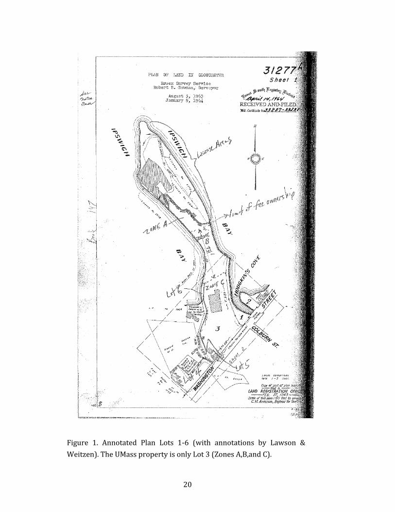
20
Figure 1. Annotated Plan Lots 1‐6 (with annotations by Lawson &Weitzen).TheUMasspropertyisonlyLot3(ZonesA,B,andC).
21
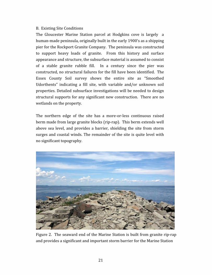
B.ExistingSiteConditionsThe Gloucester Marine Station parcel at Hodgkins cove is largely ahuman‐madepeninsula,originallybuiltintheearly1900’sasashippingpierfortheRockportGraniteCompany.Thepeninsulawasconstructedto support heavy loads of granite. From this history and surfaceappearanceandstructure,thesubsurfacematerialisassumedtoconsistof a stable granite rubble fill. In a century since the pier wasconstructed,nostructuralfailuresforthefillhavebeenidentified.TheEssex County Soil survey shows the entire site as “SmoothedUdorthents” indicating a fill site, with variable and/or unknown soilproperties.Detailedsubsurfaceinvestigationswillbeneededtodesignstructuralsupportsforanysignificantnewconstruction. Therearenowetlandsontheproperty.The northern edge of the site has a more‐or‐less continuous raisedbermmadefromlargegraniteblocks(rip‐rap).Thisbermextendswellabove sea level, and provides a barrier, shielding the site from stormsurgesandcoastalwinds.Theremainderof thesite isquite levelwithnosignificanttopography.
Figure2. TheseawardendoftheMarineStationisbuiltfromgraniterip‐rapandprovidesasignificantandimportantstormbarrierfortheMarineStation
22
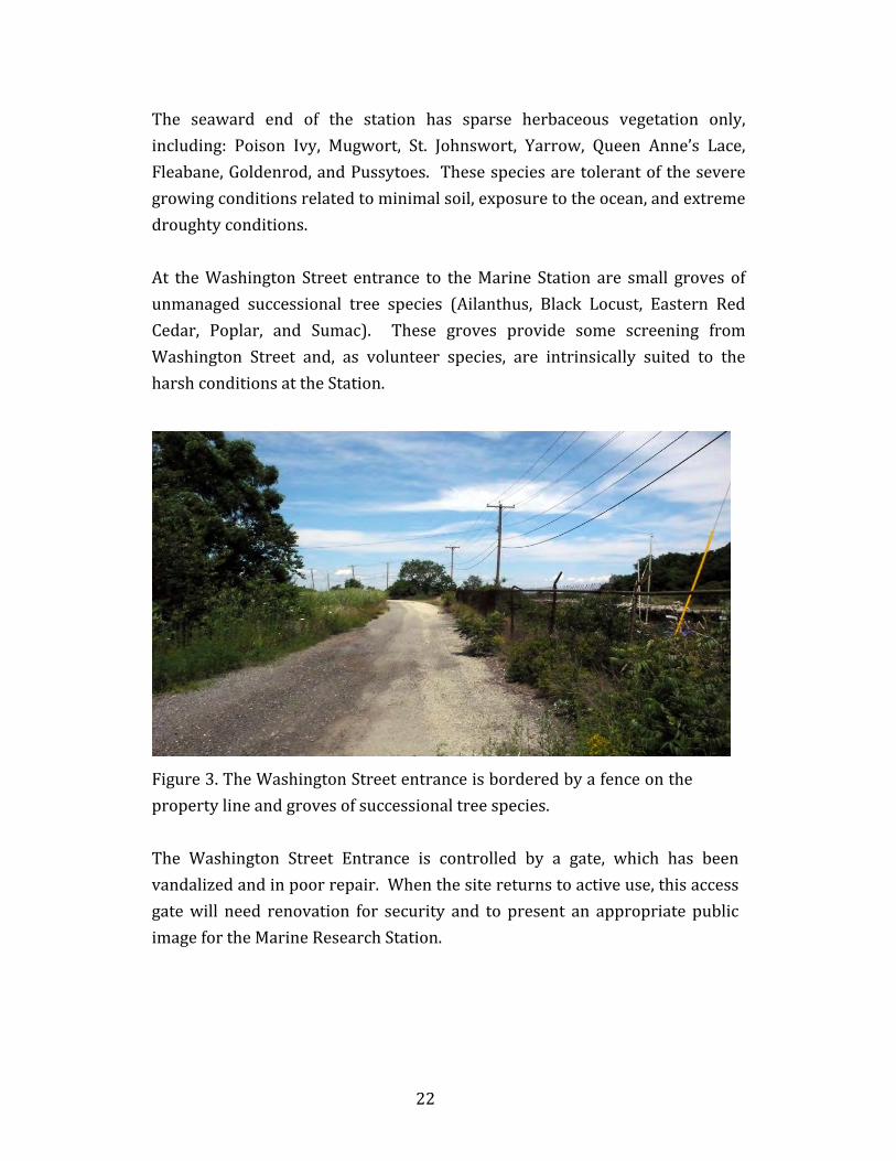
The seaward end of the station has sparse herbaceous vegetation only,including: Poison Ivy, Mugwort, St. Johnswort, Yarrow, Queen Anne’s Lace,Fleabane,Goldenrod,andPussytoes. Thesespeciesaretolerantoftheseveregrowingconditionsrelatedtominimalsoil,exposuretotheocean,andextremedroughtyconditions.At theWashington Street entrance to theMarine Station are small groves ofunmanaged successional tree species (Ailanthus, Black Locust, Eastern RedCedar, Poplar, and Sumac). These groves provide some screening fromWashington Street and, as volunteer species, are intrinsically suited to theharshconditionsattheStation.
Figure3.TheWashingtonStreetentranceisborderedbyafenceonthepropertylineandgrovesofsuccessionaltreespecies.The Washington Street Entrance is controlled by a gate, which has beenvandalizedandinpoorrepair.Whenthesitereturnstoactiveuse,thisaccessgatewill need renovation for security and to present an appropriate publicimagefortheMarineResearchStation.
23
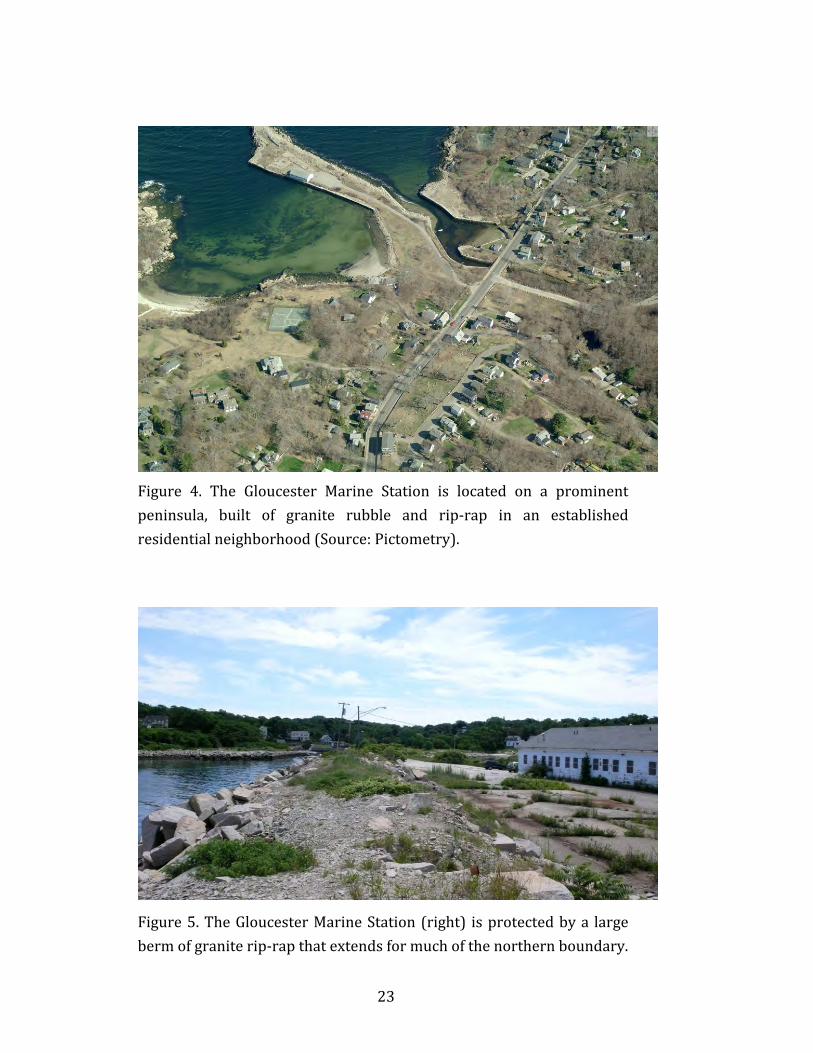
Figure 4. The Gloucester Marine Station is located on a prominentpeninsula, built of granite rubble and rip‐rap in an establishedresidentialneighborhood(Source:Pictometry).
Figure5.TheGloucesterMarineStation(right) isprotectedbya largebermofgraniterip‐rapthatextendsformuchofthenorthernboundary.
24
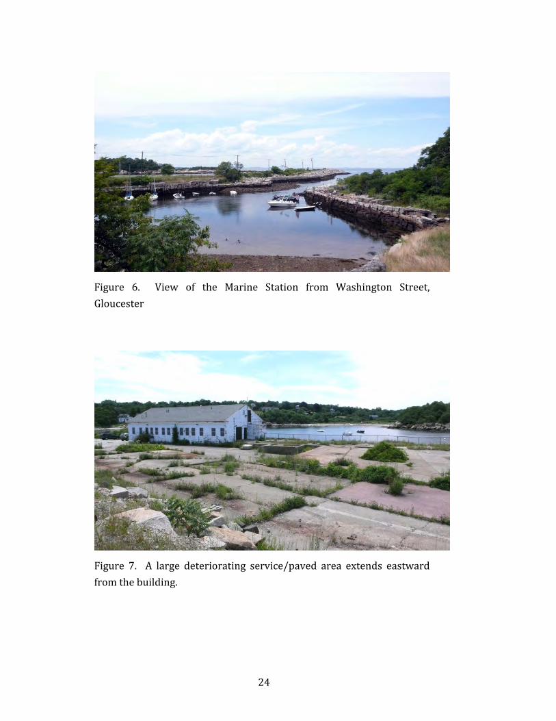
Figure 6. View of the Marine Station from Washington Street,Gloucester
Figure 7. A large deteriorating service/paved area extends eastwardfromthebuilding.
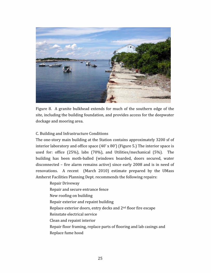
25
Figure8. A granite bulkhead extends formuchof the southern edgeof thesite,includingthebuildingfoundation,andprovidesaccessforthedeepwaterdockageandmooringarea.C.BuildingandInfrastructureConditionsTheone‐storymainbuildingattheStationcontainsapproximately3200sfofinteriorlaboratoryandofficespace(40’x80’)(Figure5.)Theinteriorspaceisused for: office (25%), labs (70%), and Utilities/mechanical (5%). Thebuilding has been moth‐balled (windows boarded, doors secured, waterdisconnected– firealarmremainsactive)sinceearly2008and is inneedofrenovations. A recent (March 2010) estimate prepared by the UMassAmherstFacilitiesPlanningDept.recommendsthefollowingrepairs:
RepairDrivewayRepairandsecureentrancefenceNewroofingonbuildingRepairexteriorandrepaintbuildingReplaceexteriordoors,entrydecksand2ndfloorfireescapeReinstateelectricalserviceCleanandrepaintinteriorRepairfloorframing,replacepartsofflooringandlabcasingsandReplacefumehood
26
These repairs are estimated to cost between approximately $100,000 and$250,000 depending on the amount ofwork performed byUMass staff andhowmuchisperformedbyoutsidecontractors.
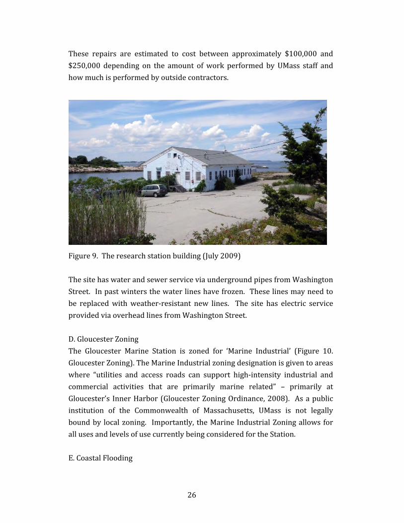
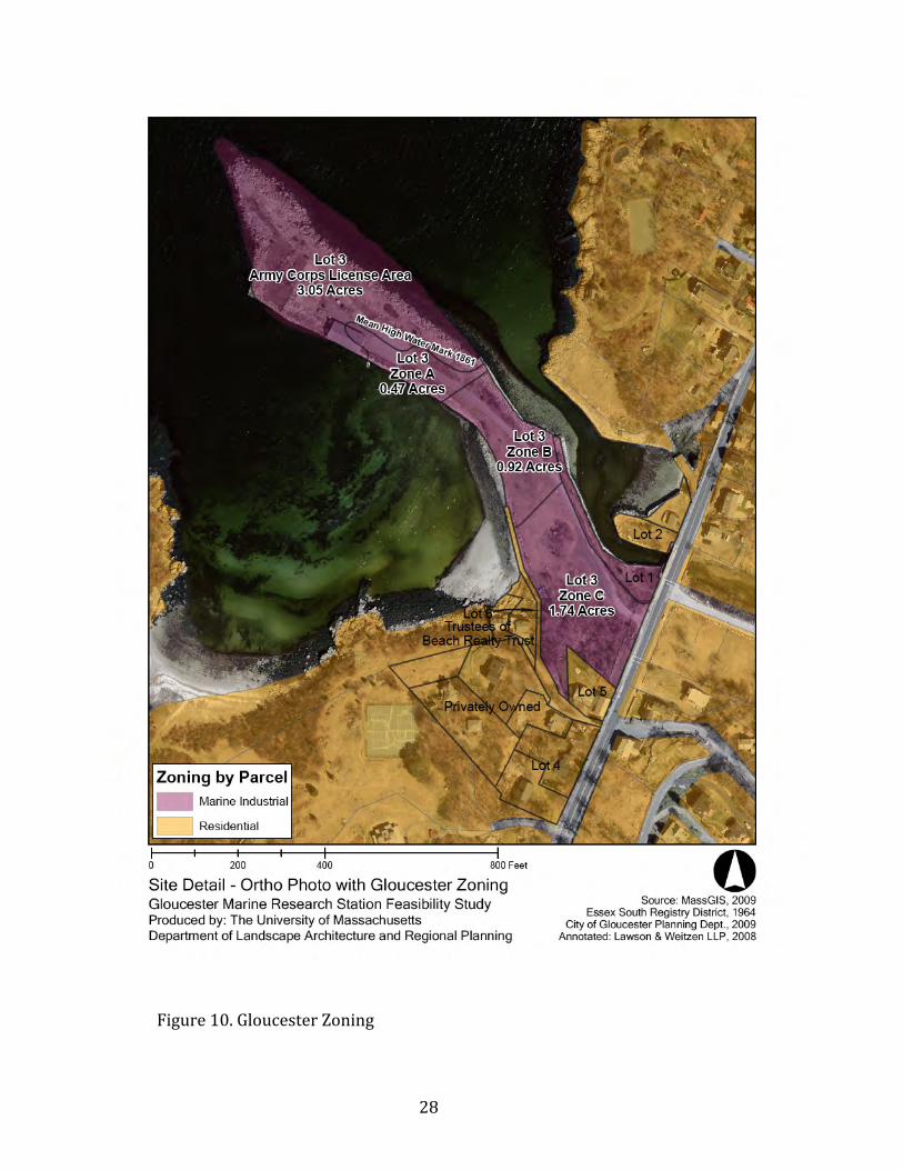
Figure9.Theresearchstationbuilding(July2009)ThesitehaswaterandsewerserviceviaundergroundpipesfromWashingtonStreet.Inpastwintersthewaterlineshavefrozen.Theselinesmayneedtobe replacedwithweather‐resistant new lines. The site has electric serviceprovidedviaoverheadlinesfromWashingtonStreet.D.GloucesterZoningThe Gloucester Marine Station is zoned for ‘Marine Industrial’ (Figure 10.GloucesterZoning).TheMarineIndustrialzoningdesignationisgiventoareaswhere “utilities and access roads can support high‐intensity industrial andcommercial activities that are primarily marine related” – primarily atGloucester’s InnerHarbor(GloucesterZoningOrdinance,2008). Asapublicinstitution of the Commonwealth of Massachusetts, UMass is not legallyboundby localzoning. Importantly, theMarine IndustrialZoningallows forallusesandlevelsofusecurrentlybeingconsideredfortheStation.E.CoastalFlooding
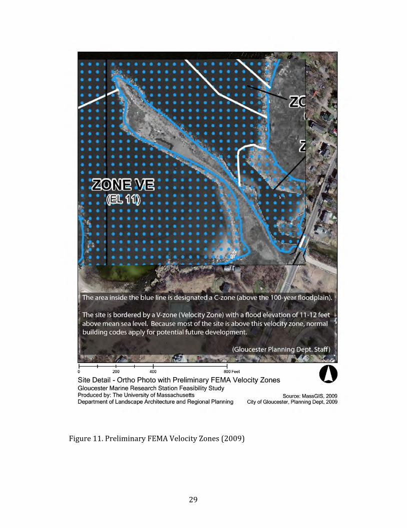
27
TheUMassGloucesterMarineStationenjoysdirect frontageonIpswichBay,andthereforealsohasaninherentriskofcoastalflooding.Apreliminary100yearfloodingmapbytheU.S.FederalEmergencyManagementAgency(FEMA2009)showsvirtuallytheentireUMasspropertytobeina“C”zone–abovethe 11’ elevation of the “Velocity Zone” (Figure 11. Preliminary FEMAVelocity Zones). A final FEMAmap is expected later in 2010. The velocitymapindicateselevationssubjecttostormandwaveaction,andconsequentlyrequires a higher standard of construction. If the final FEMA map isunchanged(laterin2010)thepropertybenefitsbynothavingtocomplywithmoresubstantialandexpensiveVelocityZoneconstruction.F.HazardousWasteMassachusettsDepartmentofEnvironmentalProtection(MDEP)keepstrackofallhazardouswastesitesintheCommonwealth.HazardouswastedataarepubliclyavailableandasofFebruary,2010theGloucesterMarineStationwasnotshowntobeanopenorclosedsitenorwas itshowntohaveanactivityuselimitation.(http://www.mass.gov/dep/cleanup/index.htm)The U.S. Environmental Protection Agency (US EPA) also keeps track of allplacesofenvironmentalconcern(dataareavailableviatheUSEPAwebsite).OnFebruary24,2010wecontactedJamesField,HazardousMaterialsControlManagerforUMassAmherstEnvironmentalHealth&Safety.WelearnedthattheGloucesterMarineStationproducedsmallamountsofhazardouswasteasa byproduct of laboratory experiments. The University was obligated toreportthistotheUSEPAandtoresponsiblydisposeofthehazardouswaste.After the facility was closed in 2008, UMA removed all the remaining labchemicals, lab waste, all batteries, fluorescent light tubes and light ballastsandhiredanoutsideconsultanttodecontaminatethelabandfumehoods.Whileitwasanactivesite,theEPAusedtheID:MAD000844621totrackthefacilityasitproducedsmallamountsofhazardouswaste.FromaMarch2010telephoneconversationwithSharonLeitch(BostonOfficeUSEPA,(617)9181647, [email protected]), we learned that the US EPA hasclassifiedtheUMassGloucesterMarineStationasinactive.
28
Figure10.GloucesterZoning
29
Figure11.PreliminaryFEMAVelocityZones(2009)
30
From this researchwe conclude that theGloucesterMarine Station is likelynot contaminated with hazardous waste or materials. While the MarineResearch Station produced small amounts of hazardous waste as thebyproduct of laboratory research all of this material has been properlyremovedandthesitehasbeendecontaminated.G.U.S.ArmyCorpsofEngineersRegulationsandPermitsThere are two U.S. Army Corps of Engineers (ACE) regulatory processespertaining to theGloucesterMarineStation: a regulatoryprocessanda realestate process. The regulatory process, handled by Karen Adams, SectionChief for Massachusetts ([email protected], (978) 3188111x828)isforworkdoneseawardofthemeanhighwatermark(dredging,filling, structures, etc.), for work done to the wharf itself (repair, expand,remove, etc.)or forworkdone that affects thedeep‐waterport (navigation,dredge,fill,etc.).Therealestateprocess,handledbyJosephRedlinger,ChiefofACE Real Estate Division ([email protected]) is for anyworkdonetotheexistingbuildingthatisbuiltontheedgeofthewharf,orforactivitiesthatoccurwithinthelicensearealandwardofthecurrentmeanhighwatermark.ApermitisneededforanyactivitiesthatfallwithinthejurisdictionofSec10oftheRiversandHarborsactof1899andSec404oftheCleanWatersAct.Ingeneral, any work done (dredging or filling, building new, repairing, orremoving existing structures) in tidalwaters orwetlands requires a permitfrom the Army Corps of Engineers. In regard to the UMass site, a USACEpermitisneededfortherepair,maintenance,orremovalofanythingseawardof themeanhighwatermark(including thebuilding, thewharf,or fillingordredgingofthechannel).Any work that was completed prior to 1968 is grandfathered, as long asUMass can show that a permitwas issuedby another agencyprior to 1968and the wharf hasn't been changed since. If the wharf has changed inconfigurationsince1964thentheremaybearequirementtofileanafter‐the‐factpermit. Itmaybepossibletousehistoricalimages(aerialphotosorthe
31
USGSLandsatphotos) toshowthat thewharfhasnotchangedsince1964 ifthepermitscannotbefound.Ifwecanshowthatthewharfhasnotchangedinconfigurationsincethe1964permit,thentheUSACEislikelynotinterestedin regulating the land shown on the deed as the license area (the areabetweenthecurrentmeanhighwatermarkandthe1861historicalmeanhighwatermark).USACE has two permit types: a general and an individual permit. Theindividual permit is longer andmore complicated and is required for non‐standard projects. Most likely anywork done in the regulated areawouldrequirethegeneralpermit.Thegeneralpermithastwocategories:Category1:noapplication is required, justnotification. State that thewharf
wasbuiltpriorto1968andthatitisgrandfathered.Category 2: an application is required; the permit works with MGL Ch. 91
licenseandisabitlongerandmorecomplicated.Seawardofthemeanhighwatermark,nothingcanbedonewithoutapermitfromtheUSACEincluding:
*Repairofthebulkheadand/orexistingbuildingbuiltonbulkheadwall.The concrete section of the bulkhead (retaining wall of wharf) isshowing visible cracking and will likely need to be repaired. Thecrack was also observed on the exterior (structural?) wall of theexisting building. Any repair to the bulkhead or building will likelyonlyrequireaUSACECategory1GeneralPermit.
* Demolishing the existing building built on the bulkhead wall. If thebuildingisdemolished,itislikelytoonlyrequireaUSACECategory1GeneralPermit
* Dredging. The deep‐water port for the Marine Station may not havebeenmaintained regularly and the channelmayneed tobedredgedforlargerresearchboatstodock.AnydredgingintheportorchannelwilllikelyrequireaUSACECategory2GeneralPermit
*Filling.IfthewharfneedstobeexpandedthetypeofpermitrequiredbytheUSACEwillvarydependingonthesizeoftheexpansion.
Landwardofthemeanhighwatermark,thereisnojurisdictionalregulationonthesitebytheUSACE(unlessworkwasdonewithoutapermitinthepast
32
thatchangedtheconfigurationofthewharf).Ifconfigurationofthewharfhaschanged since the 1964permit byMassDPW, an “after‐the‐fact” permit forthe change is required. No permit is required for a new building on thelandwardsideofthecurrentmeanhighwatermark.Note:thecurrentmeanhightidewatermarkhasnotbeenofficiallymapped.ThefollowinglicenseshavebeenissuedforgraniteshippingactivitiesattheUMass property according to the 1976 Annotated Certificate of Title(Appendix)
1904, February 24 – Permit No. 2819 – issued by the MassachusettsHarborandLandCommissionerstoRockportGraniteCompany–Book1741,P.405
1904, April 23 ‐ permit issued by the United States of America to theRockportGraniteCompany(J.A.G.O.16203)‐Book1741,Page403
1916,February2–PermitNo.4027‐issuedbytheMassachusettsHarborandLandCommissionerstoRockportGraniteCompany–Book2341,P.60
1931, June 30 – Permit No. 1312 – Issued by the MassachusettsDepartmentofPublicWorkstotheConsolidatedLobsterCo.Inc.–Book2900,P.47
1945, March 6 – Permit No. 2738 – Issued by the MassachusettsDepartment of Public Works to the Consolidated Lobster Co. Inc. –Book3398,P.486
1964, February 4 – Permit No. 4772 – Issued by the MassachusettsDepartmentofPublicWorkstotheConsolidatedLandCompany,Inc.–Book5154,P.137
H.MassachusettsWaterwaysRegulationProgram–Chapter91Chapter91oftheMassachusettsGeneralLawsapplytoanyactivitylocatedin,under,oroverflowedtidelands,filledtidelands,GreatPondsandcertainnon‐tidal rivers and streams located throughout the Commonwealth. Theseprojects and activities include but are not limited to: construction of docks,piers, wharves, floats, retaining walls, revetments, fill, dredging, beachnourishment,pilings,culverts,bridges,damsandsomewaterfrontbuildings,if on filled lands or over the water. the state
33
(http://www.mass.gov/dep/water/approvals/wwforms.htm#c91).MassachusettsDepartmentofConservationandRecreation (DCR)maintainsharbors andMassachusetts Department of Environmental Protection (DEP)grants licenses andpermits for construction and extension ofwharfs, piers,seawalls,fillingofland,amongothers.MassDEPCh91permitsandlicensesare initiated by application to the local (Gloucester) Planning Board. ThePlanning Board may hold a public meeting and has 45 days to submit arecommendationtotheDEPstatingwhetherthePlanningBoardbelievesthedevelopment would serve a proper public purpose and would not bedetrimentaltothepublic'srightsinthesetidallands.The Gloucester Harbormaster is responsible for authorizing moorings, anddockingsofvesselsatexistingdocks,piers,wharfs,etc.I.SummaryofSiteandBuildingConditionsandDevelopmentPotentialThe UMass Amherst Marine Research Station has extraordinary access toIpswich Bay for ocean, and estuary‐based research, and enjoys a sheltereddeep‐water dock and mooring area. The property title is complicated andmayrequire further legal research,oraction inMassachusetts landCourt toresolve. Theonsitebuilding (3200 sf) is inpoor condition andwill requiremodestrenovationstosupportresearch.TheCityofGloucester,andstateofficials,arefirmlyinsupportofreneweduseofthestation.AlthoughnotapplicabletotheUniversityofMassachusetts,thecity’szoningofMarineIndustrialallowsforawiderangeofusesincludingtheanticipatedresearchandofficeuses.Asacoastalproperty,thesiteissubjecttoflooding,butappearstobesafelyabove theFEMAVelocity Zone, thus allowing for conventional construction.TheUSArmyCorpsofEngineersandtheMassachusettsWaterways(Chapter91)regulationsapplytothesite,butappearnottopresentmajorlimitationsforanticipateduses.
34
4.AlternativeFutureDevelopmentOptions
A.PotentialUsesandUsersoftheResearchStationA major component of this study was to identify potential research andgovernmentalpartners to shareuse, and contribute to the construction andoperatingcostsoftheUMassGloucesterMarineStation. Thiseffortincludedmeetings and/or communication with: City of Gloucester officials; UMassAmherst officials; The Center for Economic Development at UMass; StateSenator Bruce Tarr and Representative Ann‐Margaret Ferrante;representatives from Salem State College, Massachusetts Institute ofTechnology,Massachusetts Division ofMarine Fisheries; The Large PelagicsCenter;andNewEnglandBiolabs.A letter was sent from Michael Malone, Vice Chancellor for Research andEngagement, UMA to all other UMass campuses (Worcester, Boston,DartmouthandLowell)‐requestingrepliesofinteresttocollaborateinuseoftheGloucesterstation.The survey of collaborative use of the Gloucester Station resulted in thefollowingspecificinterests:LargePelagicsResearchCenter: TheNSF‐fundedCenter,formerlylocatedatthe University of New Hampshire, is relocating to the Gloucester Station,joiningtheCollegeofNaturalSciencesofUMassAmherst.UMass Boston: Interests in collaborating in use of the Station include theDepartmentsof:Biology, Environmental, Earth andOceanSciences and theUrban Harbors Institute. These departments’ research include: marinebiologyandcoastalecology,environmentalscience,rockyintertidalandsub‐tidal research, and the sustainability of urban harbors and coastal livingenvironments. Nospecifics regardingspaceorequipmentrequirementsareidentified at this time. Contact: Zong‐Guo Xia, Vice Chancellor for Research([email protected]).
35
Massachusetts Division of Marine Fisheries (DMF): The UMass GloucesterpropertyappearsideallysuitedtosupportseasonalresearchforMFI‐relatedfaculty and students. They also see potential to rely on theMarine StationpropertytostageandprovideinfrastructuresupportforotherMFIandDMFprogramactivities.Ourrecommendationsincludeusingtheexistingbuildingforeitherstorageuseorforasinglelargemeetingroom.Theyrecommendconstruction of a new building to house the MFI‐Large Pelagics ResearchCenter(LPRC),wet‐labs&drylabs,walk‐infreezers,andadditionalMFI‐DMFresearchaccommodations(officespaceforfacultyresearchersandstudents).New construction should be situated at the property entrance where themostaccessibleanduseful land forbuildingandparkingexists.Thesizeofthebuildingshouldrangefrom5,000(ifprimaryuseisforLPRC&DMF)to10,000squarefeet;costswouldrangefrom$1millionto$2million.DMFisconstructingan18,000sq.ft.steel‐masonrybuildinginNewBedfordandwerecommendasimilarprojectforGloucester.Althoughprimarily involvedwith fisheriesscience,DMF is compatiblewith
other similar researchers, as well as education programs. They are very
much interested in partnerships and helped create the MFI to share the
expertise of theUniversity andDivision ofMarine Fisheries. In the area of
fisheriessciencewespecializeinsurvey/monitoringanddevelopingfishlife
history information to help estimate fish stock status for numerous New
Englandfishspecies.Tocompletethisworkweconductatseatrawlsurveys,
satelliteandacousticfishtagging,andscientificdiveprograms.Additionally,
they are involved in bacteriology and biotoxin work to help classify and
manage the state’s shellfish harvest areas, developing anadromous fish
passagefacilities,andmarinehabitatrestoration.
TheDivisionhascommittedasizeableamounttohelpfundtheMFI‐LPRC(up
to a $250,000 for program support), but they would consider additional
fundingsupporttohelpconstructasharedbuilding(MFI)attheUniversity’s
Gloucester Marine Station. Contact: Paul Diodati, Director of Division of
36
MarineFisheries,251CausewayStreet,Boston,MA02114 (617)6261530
Salem State College: For the past 15 years Salem State has usedHodgkins
CoveattheGloucesterMarineStationand,untilthedeathofProfessorHerb
Hultin,thelaboratorybuilding.SalemStatewouldliketocontinuetoaccess
thecoveandusetheexistingbuildingoranewbuildingtosupportmultiple
lab and field studies. The marine Station’s primary advantage is its direct
access to variousmarine habitats. The addition of a small dockwith some
mooring siteswouldallowSalemStateandother researchers toeffectively
sample andmonitor themarine environment. Theywould like to continue
and expand Field projects, which include monitoring of local shellfish
populations,especiallymussels.Remotesensingbuoyscouldbedeployedto
monitor local environmental conditions, linking with buoys on the South
ShoreandtheNOAAsystem.Thisenvironmentalinformationwouldbevital
in assessing the spawning and recruitment activities of local species. The
marine station would provide Salem State Biology faculty a base for
extensionservicestolocalfishersandthegeneralpublic.Thelabwouldalso
support Salem State’s existing outreach efforts at schools throughout Cape
Ann, introducing students to topics in marine science and resource
management. Existing or new lab space would support shellfish culturing
activities and basic studies on fish physiology and reproduction. The lab
wouldalsoallowforanalysisofsedimentandwatersamples.
SalemStateenvisionsafieldstationwithananalyticallabof300sq.ft.that
wouldallowforprocessingofsamples.Additionalspace,approximately1000
sq.ft.,forseawatertanksandaflowthroughseawatertablewouldbeneeded
forshellfishandfishmaintenance.Thelabwouldneedcommercialelectrical
service,compressedairandgasconnections.Acentralfumehoodwouldalso
be useful. The labwould need a filtered seawater system equippedwith a
chiller. Additional space for educational support should consist of a
37
conference room with some office space for visiting researchers. The
buildingwouldneedinternetservicewithseveralcomputerstations.Finally
bathroom facilities should include showers for cleanup of personnel and
equipment,specificallySCUBAactivities.
Salem State wouldwelcome collaborative interactions with other agenciesandinstitutionswithaninterestinmonitoringlocalmarinehabitatsandtheculture of commercial marine species. Division of Marine Fisheries andothers could likely use a dock facility. SS could also collaborate onenvironmentalsampling.Additionallabspacewouldbeneededforpartnersundertakinganyexperimentalwork.Contact:Dr.KristinEsterberg–Provost;Dr.MarkFrageau–Professor;DirectorCatCove;BethAnneBower–SpecialAssistanttothePresident.Massachusetts Institute of Technology: Autonomous Underwater VehiclesLaboratory (AUV). The MIT AUV lab designs, builds, and operatesautonomous underwater vehicles for research in robotics and marineecology.The largestvehicleAUVcurrentlyuses is theOdyssey IV (length6feet,draft4feet,1000pounds).Thevehiclehasonboardcomputers,sensors,andcamerasand it isused to inspectmanmadeunderwaterstructuresandsurvey the ocean floor in order tomonitor the spread of invasive species.They are interested in establishing a field office in Gloucester that willprovide access to the water, space for vehicle construction/repairs, andstorageof thenecessarysupportequipment.TheGloucesterMarineStationmaybeanexcellentlocationtoconductourmarineresearchactivities.Theyowna20‐footsteelshippingcontainerthathasbeeninsulatedandconvertedintoa fieldoffice/laboratory.Agantry cranehasbeen installed that canbeextended from the container up to 10 feet for hoisting and deploying ourvehicles. This container would provide adequate space if it could besemi‐permanentlyparkedinaspacewithgoodaccesstothewater.Accesstothewaterfromadockorboatrampisveryimportant.Theywouldalsomakeextensiveuseofajibcranetodeployandrecoverthevehiclefromthewaterifitwereavailable.Itwouldbeverybeneficialiftheelectricalsysteminthecontainer (lights, outlets, baseboard heat, air conditioning) could be
38
connectedtothepowergrid.Ageneratorisanotheroption.Theyalsoowna12‐footmotorboat thatweuse tosupportoperationsof theAUV.Thisboatcouldbestoredonitstraileronlandwhennotinuse.
MIT’s needs are generally compatiblewith other users.Most other uses ofthewaterfrontwouldnotinterferewithouractivitiesaslongastheydonotpreventwateraccessorplacemanyobstaclesinthesurroundingwatersuchasnetsormoorings.
Ourresearch is fundedbyvariousorganizations including federaland localagencies and corporate sponsors. Our budgeting directors will follow upseparately with a more detailed reply. Concern for security of valuableresearch equipment. Contact: Justin Eskesen, Senior Software Engineer,Autonomous Underwater Vehicles Laboratory, Massachusetts Institute ofTechnology,SeaGrantCollegeProgram,292MainStreet,BuildingE38‐370,Cambridge,MA02139(617)2533438,[email protected]:It isanessentialpartofNSCC’smissiontoprepareitsstudentsfortheworkforce.Witharegionaleconomyincreasinglymorereliantonscienceandtechnologysectors,NSCCisuniquelypositionedtoworkwiththeCityofGloucestertoproviderelevanttechnicaleducationtoarearesidentstoensureboththeirfutureaswellastheeconomicgrowthoftheregion.Thisisparticularlyimportantinfieldssuchasmarinetechnology,designatedasadevelopingclusterwithgreatpotential.NSCC’s Gloucester Initiative is based in the development of a MarineTechnology program to be sited in Gloucester. No urban center alongMassachusetts’ north shore demonstrates more need for such a project:revitalizing the fishing industry while promoting new marine‐relatedtraining and increasing opportunities for residents to earn a family‐supportingwage.Becausetheinitiativewillactasaneconomiclightningrodfortheregion,itwill draw on extensive collaborative resources in the area ‐ small marinebusinesses, the North Shore Workforce Investment Board (WIB),community‐basedorganizations that serveGloucester residents, andpublic
39
schools.Planningwill address theneed foralternative career training (andre‐training) for adult learners, provide specialized programs to regionalindustry and link to middle school/high school science and technologycoursework.Goals:
Provide a regional Marine Technology Center partnering withgovernment, business & industry, higher education, public schools andcommunityleaders.Provideresourcesforareasmallmarine‐relatedbusinessestostart,grow,andthriveintheregionalnorthshorearea.ExpandNorthShoreCommunityCollegeacademicprogramming (creditand non‐credit) in Marine Technology, including Marine Systems,Electrical Machinery, Communication‐Navigation, Marine Trades(outboard/inboardmotors),andMarineSafety.Partner NSCC faculty and teachers in public schools to developmiddleschool and high school curriculum in marine science and technicaltrainingthatwillpreparestudentsforlocalcareers.Collaborate with regional community‐based GED, ESL, and literacyprogramstodesignandoffershort‐termworkforcetrainingprograms.Itisanticipatedthatpotentialfundingsourceswouldinclude:theFederalEconomic Stimulus Bill (ARRA); the Workforce Competitiveness TrustFund; federal DOL Community‐Based Job Training grants; andcollaboration with the North Shore Workforce Investment Board.Contact: Dr. Wayne M. Burton, President, North Shore [email protected]
KenRiafandSteveParks,Gloucesterresidentsexpressedinterestinthesite’sviability as a staging, dockage and storage area for persons conductingcommercial shellfish aquaculture in Ipswich Bay. Contact: Ken Riaf, 18PleasantStreet,Gloucester,Massachusetts01930([email protected]).With these potential partners, and familiarity with the site’s physical andregulatorycharacteristics inmind,wedeveloped3alternativedevelopmentoptions.Theseoptionsindividuallyandcollectivelyshowhowthesitecanbe
40
sensitively developed to meet various levels of collaborative interest,respectingtheresidentialcharacteroftheneighborhood,andworkingwithintheregulatoryconstraints.B.AlternativeDevelopmentOptionsThreealternativedevelopmentoptionshavebeenpreparedtoillustratesiteplans for varying levels of use based on the survey of interest to potentialpartners. It is reasonable to assume that any of these optionsmay occurgiventhesignificantinterestinpartneringwithUMassAmherstattheMarineStationidentifiedthroughthisstudyandfromothers’efforts.Theseoptionsare developed and presented here for discussion and comparison only.These are NOT specific proposals or plans. The three options represent arangeofintensityofuseatthesite,startingwithamodestplantoadapttheexisting building in Option A, to larger new construction capable ofsupporting a level of use that is higher than identified through this study.The optionwith the largest building area is not amaximumbuild out – itshows a development of over 15,00 gsf, significantly larger than needsidentified in the study. Future plans will need to be developed further,discussed and vetted for cost, specific space configurations, environmentalpermittingandpartnerandotherneeds.Tosupporttheintendedresearchandadministrativeusesinalloptions,theHodgkins Cove site will be improved for security, access, storage and toimprovethelandscapecharacter.ThefenceandgatewillbereplacedalongWashingtonStreet,thestonewallrepairedandnewplantingsofnativesalt‐tolerant seacoast trees and shrubs will be installed – to present a morefavorable public image and screen the buildings and storage fromWashington Street. At the other end of the property, in theArmyCorps ofEngineers license area, the deteriorating concrete will be removed andlandscapewill be restoredwith native, salt water‐tolerant plantings and atrailandobservationareawillbecreatedforrecreationandenvironmentaleducation. In addition to the building and driveway work, all options, asdevelopedherefordiscussion,willincludeaboatrampforlaunchingtrailer‐able research vessels, a dock along the building bulkhead for efficientloading/unloading,andasecureoutdoorstoragearea(s)forequipmentandsupplies–consistentwith,andinsupportof,theprimaryuses(s)relatedto
41
marineresearchsupport.Option A is the most modest and most likely first phase of reuse of theStation. This option involves a restoration of the existing building asdescribedearlieratacostbetween$108,000and$242,000–dependingonhowmuch of the work is done by UMass Amherst staff and howmuch iscontracted. Therestoredbuildingwillhaveanewparking lotand3,000sfstorage area (Figure 12. Option A‐ Future Development, UMass AmherstGloucester Marine Station). This option could support all the potentialresearch partners identified to date, and takes advantage of the facility’sdockageandaccesstosaltwaterforlaboratoryuse.OptionBretainsalloftheimprovementsandnewfacilitiesofOptionAandadds a new 1 story research/office building of 5,000 sf with additionalparkingandanadditional3,000sfsecureoutdoorstoragearea.Thebuildingissitedontheeasternendofthesite,behindthenativeplantingstoscreenthebuilding fromtheroad,andcloseto therequiredparkingarea. (Figure13. Option B ‐ Future Development, UMass Amherst Gloucester MarineStation).Thisoptionwouldsupportadditionalusers/usesinanewbuilding,whileretainingtherestoredexistingbuilding.Accesstodeep‐waterdockageandsaltwaterforlaboratoryusewouldalsobeprovided.OptionC retainsall of the improvementsandnew facilitiesofOptionAandadds a new 2 story research/office building of 15,000 sf with additionalparking and an additional 6,000 sf secure outdoor storage area. As withOptionB,thebuildingissitedontheeasternendofthesite,behindthenativeplantings to screen thebuilding from the road, and to benear the requiredparking area (Figure 14. Option C – Future Development, UMass AmherstGloucesterMarineStation).Thisoptionshowsthatasignificantylargernewbuilding can fit easily on the eastern end of the site without imposing orintrudingonthecharacteroftheresidentialneighborhood.
42
Figure 12. Option A – Future Development, UMass Amherst GloucesterMarineStation
43
Figure 13. Option B – Future Development, UMass AmherstGloucesterMarineStation
44
Figure14.OptionC–FutureDevelopment,UMassAmherst,GloucesterMarineStation
45
Figure15.ComparativeStatistics,OptionsA,BandC,UMassAmherstGloucesterMarineStation
C.SummaryThis study was done in response to a unique challenge and opportunitypresented to the University of Massachusetts Amherst. A once‐thrivingresearchstationfellintodisusewiththepassingofitsacademicleader.Withtheresearchstationlocatedover100milesfromtheAmherstcampus,therewere no immediate users seeking access to the station for research.Meanwhile, leadersandofficials fromtheCityofGloucesterbecameactivelyinvolved in promoting renewed use(s) of the station. The UMass AmherstCenterforEconomicDevelopmentsponsoredthisstudyasanimportantstepin revitalizing the facility for research and economic benefits to Gloucesterand the northern sector of the BostonMetropolitanArea. The study foundandorganizeddocumentsanddatatoanswermanyofthequestionsthatwillneed answers as the station reactivates and expands. The study alsoidentified and organized potential users of the station, based on commonresearch interests, who may join as partners in the future. This study isexpected to play a small but important role in this larger ambition – torevitalize theUMassAmherstGloucesterMarineStationtoconductresearchto support healthy, productive and sustainable use of marine resources inMassachusettsandbeyond.
OptionA–renovateExistingBuilding
OptionB–ExistingBuilding+5,000sfBuilding
OptionC–ExistingBuilding+15,000sfBuilding
GrosssfBuildings 3,200sf 8,200sf 18,200sfBuildingFootprintArea
3,200sf 8,200sf 10,700sf(2storybldg)
SecureOutdoorStorage
3,000sf 6,000sf 9,000sf
Parking 20+2HP 42+4HP 88+6HPRoadLength 1300lf 1300lf 1300lfOther Boatramp+dock Boatramp+dock Boatramp+dock
46
5.Appendices
A.GloucesterMarineStationHistoryo GraniteShipping
1856,December10–Landtransfer,BeniahColburnetal,LorenzoBerry‐Book
580,p76
1904,April23‐permitissuedbytheUnitedStatesofAmericatotheRockport
GraniteCompany(J.A.G.O.16203)‐Book1741,Page403
1904,February24–PermitNo.2819–issuedbytheMassachusettsHarborand
LandCommissionerstoRockportGraniteCompany–Book1741,P.405
1916,February2–PermitNo.4027‐issuedbytheMassachusettsHarborand
LandCommissionerstoRockportGraniteCompany–Book2341,P.60
1927,June14–DeedchangesbetweenBenjaminA.BerryetalandtheRockport
GraniteCompany‐Book2728,Page84
o LobsterHarvesting 1931,June30–PermitNo.1312–IssuedbytheMassachusettsDepartmentof
PublicWorkstotheConsolidatedLobsterCo.Inc.–Book2900,P.47
1945,March6–PermitNo.2738–IssuedbytheMassachusettsDepartmentof
PublicWorkstotheConsolidatedLobsterCo.Inc.–Book3398,P.486
o ChickenFarmingatHodgkinsCove 1963,June&July–Deedoflots1&2totheCityofGloucesterfromthe
ConsolidatedLandCompany,Inc.‐Book5084,p.543
1964,February4–PermitNo.4772–IssuedbytheMassachusettsDepartmentof
PublicWorkstotheConsolidatedLandCompany,Inc.–Book5154,P.137
1966,November–Lots4&5deededtoprivatecitizensfromtheHodgkinsCove
Corporation.
1970,June4–Lot6conveyedtotheCityofGloucesterfromtheConsolidatedLand
Company,Inc.–LandCourtPlan31277C
1970,June18–Land(Lot3)deededtotheUniversityofMassachusettsfoundation
Inc,fromtheHodgkinsCoveCorporationfor$67,500–EssexSouthRegistry
DistrictCertificatesNo.34761
1970,June18‐Lot6conveyedtotheTrusteesofBeachRealtyTrust
1976,June8–LandconveyedtotheCommonwealthofMassachusettsfortheuse
oftheUniversityofMassachusettsfromtheUniversityofMassachusetts
Foundation,Inc.
47
o UMassResearchStation–underthedirectionofHerbertO.Hultin http://www.boston.com/news/local/articles/2008/07/21/a_legacy_of_research/
http://www.amherstbulletin.com/story/id/73016/
ProteusIndustries‐spawnedfromUMassresearchwww.proteusindustries.com
Foundedin2001byStephenKelleher,Ph.D.,ProteusIndustriesisthecompanybehind
NutriLean.Arenownfoodchemist,Dr.Kelleherspentyearsdoingproteinandlipid
researchwithAdvanceProteinTechnologies,andasaresearcheratUMass‐Amherst
MarineStationinGloucester,MA.
48
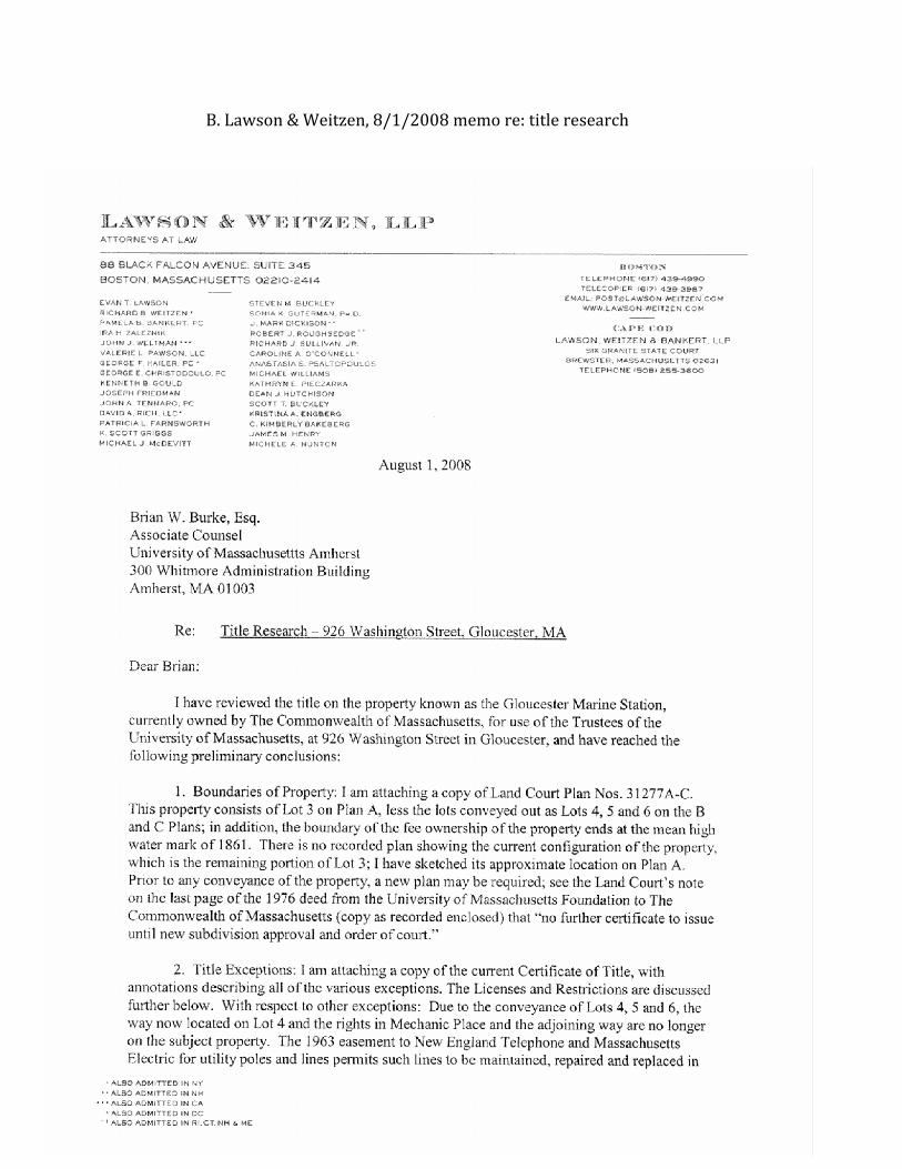
B.Lawson&Weitzen,8/1/2008memore:titleresearch

49
50
C.CityofGloucesterMarineIndustrialZoning
CityofGloucesterZoningTheCityofGloucesterhaszonedtheGloucesterMarineStationparcel‘MarineIndustrial’.TheMarineIndustrialzoningdesignationisgiventoareaswhere“utilitiesandaccessroadscansupporthigh‐intensityindustrialandcommercialactivitiesthatareprimarilymarinerelated”–primarilyatGloucester’sInnerHarbor(GloucesterZoningOrdinance,2008).AsapublicinstitutionoftheCommonwealthofMassachusetts,UMassisnotlegallyboundbylocalzoning.TheMarineIndustrialZoningallowsforallusescurrentlybeingconsideredfortheStation.
TypicallytheMarineIndustrialZoningdesignationdoesnotrequireaminimumlotarea;however,astheGloucesterMarineStationbordersaresidentialdistrict,theminimumlotareais“thesameastheabuttingresidentialdistrictwiththesmallestrequiredminimumlotarea.”(GloucesterZoningOrdinance,2008).
ThedimensionalrequirementsforallallowedusesotherthandwellingunitsandshoppingcentersfortheMarineIndustrialdistrict:
Minimumlotarea:0’Minimumlotwidth:0’Minimumfrontage:0’Minimumfrontyard:10’Minimumsideyard:0’unlessthepropertyabutsaresidentialdistrictthen10’Minimumrearyard:0’unlessthepropertyabutsaresidentialdistrictthen10’Maximumbuildingheight:40’Minimumdistancefromprincipalbuildingforaccessoryuse:10’Maximumbuildingheightforaccessoryuse:12’Maximumlotcoverage:100%Abuildingbuiltonalotthatadjoinstheharborshallbesetbackfromonesidelotlinebyadistanceequaltoonethirdofthebuildingheightbutnotlessthan10’
51
IntheMarineIndustrialarea,“nouseofthewater’sedge,oranareaatgroundlevel20’backfromthewater’sedge,shallbepermittedunlesssuchuserequiresaccesstowater‐bornevessels.”(GloucesterZoningOrdinance,2008)Dependingontheintendeduseparkingrequirementsvary.(SeeGloucesterZoningOrdinance–Sec.4.1)Offstreetloadingmayberequiredifthedeliveryofgoodsisasubstantialpartoftheoperationsofthefacility.(GloucesterZoningOrdinance‐Sec.4.2)MarineIndustrialdoesnottypicallyallowforresidentialuses.However,aspecialpermitissuedbytheBoardofAppealsmayallowaboardinghouse,roominghouse,lodginghouseorhostel.Temporaryresidentialuseofmobilehomesisallowedfollowingfireorothernaturaldisasters.MarineIndustrialzonedlandmaybeusedforthefollowing:
Communityserviceuses:Public,religious,orothernon‐profitschool,buildingoruseMunicipalusePublicutilityfacilityexclusivelyservicingabroadarea(5squaremilesormore)NurserySchool,daycarecenterTradeSchool,industrialtrainingcenter
OpenUses:Agriculture,horticulture,floriculture,includingfarms,greenhouseandgardens,onlotslargerthanfiveacresSalesoftheproductsgrownabove,providedthatallsuchitemsareproducedonsite.Outdoorrecreation,otherthanthoseprohibitedbelow,operatedbyagovernmentalagencyorauthorityOthercommercialoutdoorrecreationactivitiesSeasonalsalesofChristmastrees,wreaths
BusinessUses:Officebuildingcontainingmorethan2500sq.ft.offloorareaMarinerelatedsalesorrental,limitedprimarilyintheMIDistricttocommercialfishingvesselsContractor’syardFueloriceestablishment,otherthangasstationsFeedorbuildingmaterialsestablishment
52
IndustrialUses:Manufacturing,processing,orresearchProcessingorcoolingnotconformingtotheperformancecriteriaofGloucesterZoningOrdinancesec4.4Bulkstorage,warehousing
OtherPrincipleUses:ParkingofmotorvehiclestoserviceauselocatedandpermittedintheNeighborhoodBusinessDistrictArts,crafts,andsalesofarts,orcraftsifmadeonthepremisesNoncommercialradiotransmission,withwireantennaorroof‐mountedtowerextendingnohigherthan10’abovetheroofline.
AccessoryUses:Garageorstorageshed,accessorytoallowedorpermitteduseParkingorstorageofagriculturemachineryusedonthepremisesSignsManufacturingaccessorytoretailing,employingmorethantenpersons,withmajorportionofproductssoldonthepremisesEmployeedwellingaccessorytoindustryOfficeforoneprofessionalinhisorherresidenceHomeofficeexcludingtheemploymentofothers,exteriorsigns,andvisitsbycustomers,clients,orotherpersonsinconjunctionwiththebusinessMonitoringtowerforcommercialland‐basedwindenergyconversionfacilityYardsaleslastingnomorethantwodays,includingset‐upandtake‐downtime,conductednomorethantwotimesinacalendaryear.
UnderSpecialPermitbytheCityCouncilortheBoardofappeals,thefollowingusesmaybeallowed:
CommunityServiceUses:PersonalwirelessservicefacilityPublicutilityfacilityexclusivelyservicingtheimmediateneighborhood(5squaremilesorless)Cluborlodge,registeredasanonprofitorganization
53
PhilanthropicinstitutionAirport,heliport
OpenUses:Boatlaunching,docking,ordockingstructuresDockingandoperationofcasinoships
BusinessUses:Bank,automatictellermachinesRestaurantwithorwithoutoutdoorseatingand/ortakeoutMotorvehiclesalesorrentalMotorvehicleservice,fueling,storage,orrepairMarinerelatedservice,storage,orrepair,limitedprimarilyintheMIDistricttocommercialfishingvesselsProteinrecoveryplantBuildingtradesmanorcontractor,withoutoutdoorstorageofmaterialsorheavyequipmentotherthanonetruckwithaGVWofnotmorethan12,000poundsStonemason’syardShoppingCenterDrive‐throughfacility
IndustrialUses:Trailertruckpark,freightortransportationterminalfacilitiesStorageoftoxicorhazardousmaterialsorwastesincidentialtoindustrialoperationsconductedon‐site,asauthorizedbytheMassDEPpursuanttoMGLch.21c
OtherPrincipleUses:ParkingofmotorvehiclestoserviceausepermittedinthesamedistrictTemporarystructuresortemporaryusesnotconformingCommercialradiotransmissionNoncommercialradiotransmission,withwireantennaorroof‐mountedtowerextendinghigherthan10’abovetheroofline.
AccessoryUses:HomeoccupationCommercialland‐basedwindenergyconversionfacilitiesCommercialland‐basedwindenergyconversionfacilitiesoncity‐ownedland

54
ThefollowingusesarespecificallynotallowedinMarineIndustrialareas:
CommunityServiceUses:Nursinghomes,convalescenceorresthomes,hospitalsCemeteryAnimalhospitaloranimalshelterBusinessorcommercialschoolotherthanthepreviouslyalloweduses
OpenUses:Agriculture,horticulture,floriculture,includingfarms,greenhouseandgardens,onlotssmallerthanfiveacresWildlifearea,reservation,orsimilaruseRidingSchool,stableGolfdrivingrange,driveintheater,amusementpark,racetrack,orsimilarcommercialoutdoorrecreationMiniaturegolf,andbaseballorsoftballbattingcagesGolfcourse,standardorpar‐threeCommercialpicnicoroutingareaSupervisedCamping
BusinessUses:Officebuildingcontaininglessthan2500sq.ft.offloorareaFuneralhomeAnimaldaycare,animalgrooming,animalboarding,animalkennel,Laundry,Laundromat,ordrycleaningestablishment
IndustrialUses:Junkyard,Fillorremovalofsoil,stone,orotherearthproducts
AccessoryUses:Indwellings,regardlessofsize,therentingofnotmorethanthreeroomsaslodging,withoutseparatecookingfacilities,tonotmorethanthreelodgersDinninghalls,orshops,whollywithinamotelorhotelAutomaticamusementdevicesRecreationaluseaccessorytoadwellingforuseofresidentsandnonpayingguestsResidentialland‐basedwindenergyconversionfacilities
Accessoryin‐lawapartments
55
D.LargePelagicsResearchCenterFactSheet