Embed Size (px)
Citation preview
1
GLP Taipei Nodal Office
Room 603, Hao-han Hall
No.1, Section 4, Roosevelt Road
Da’an District Taipei, Taiwan
10617
TEL: +886-2-3366-3488
FAX: +886-2-3366-1702
GLP Contributing Project
Proposal
Land Resources Core Project
Funding source: Department of Natural Sciences and Sustainable Development
Ministry of Science and Technology
Funding period: 1st August 2016 - 31st July 2019
2
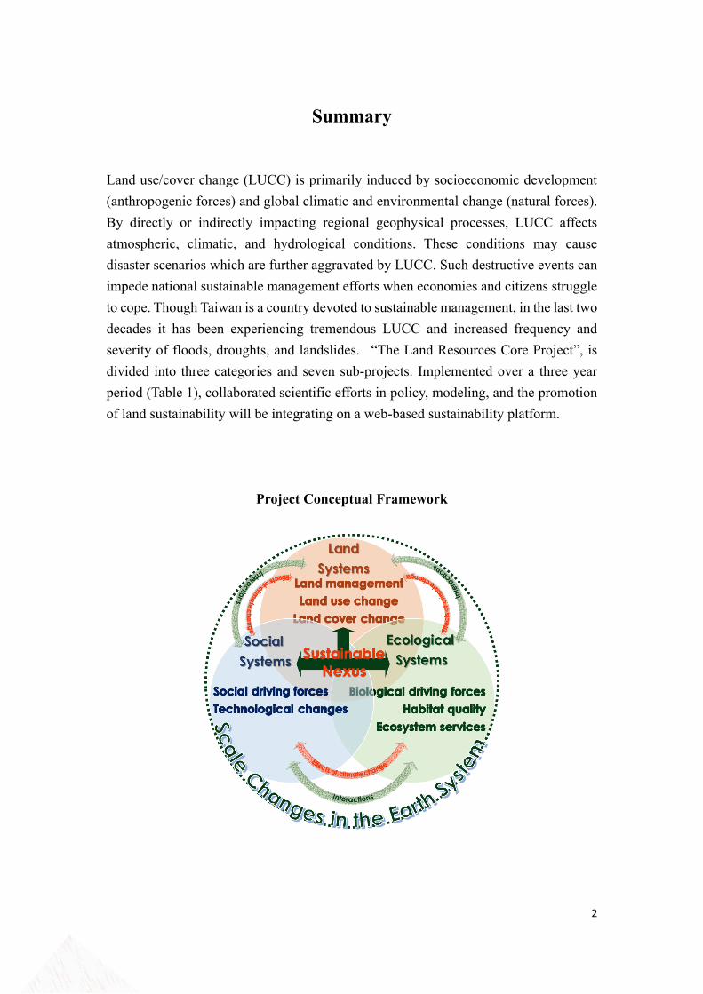
Summary
Land use/cover change (LUCC) is primarily induced by socioeconomic development
(anthropogenic forces) and global climatic and environmental change (natural forces).
By directly or indirectly impacting regional geophysical processes, LUCC affects
atmospheric, climatic, and hydrological conditions. These conditions may cause
disaster scenarios which are further aggravated by LUCC. Such destructive events can
impede national sustainable management efforts when economies and citizens struggle
to cope. Though Taiwan is a country devoted to sustainable management, in the last two
decades it has been experiencing tremendous LUCC and increased frequency and
severity of floods, droughts, and landslides. “The Land Resources Core Project”, is
divided into three categories and seven sub-projects. Implemented over a three year
period (Table 1), collaborated scientific efforts in policy, modeling, and the promotion
of land sustainability will be integrating on a web-based sustainability platform.
Project Conceptual Framework
3
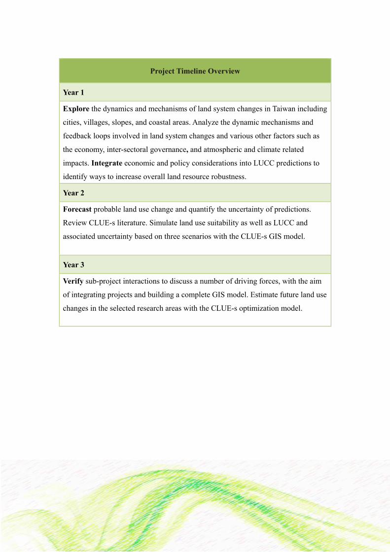
Project Timeline Overview
Year 1
Explore the dynamics and mechanisms of land system changes in Taiwan including
cities, villages, slopes, and coastal areas. Analyze the dynamic mechanisms and
feedback loops involved in land system changes and various other factors such as
the economy, inter-sectoral governance, and atmospheric and climate related
impacts. Integrate economic and policy considerations into LUCC predictions to
identify ways to increase overall land resource robustness.
Year 2
Forecast probable land use change and quantify the uncertainty of predictions.
Review CLUE-s literature. Simulate land use suitability as well as LUCC and
associated uncertainty based on three scenarios with the CLUE-s GIS model.
Year 3
Verify sub-project interactions to discuss a number of driving forces, with the aim
of integrating projects and building a complete GIS model. Estimate future land use
changes in the selected research areas with the CLUE-s optimization model.
4
Table of Contents
Summary
I. Introduction
II. The Land Resources Core Project
Project Aim and Objectives
Sub-Projects
i. Modeling Dynamic Changes and Mechanisms of Land
Systems
ii. Database Establishment of Land Use/ Cover Changes and
Index Application on Slope Land
iii. Urban Land Use Change and Resilient City Land
Management in Taiwan Area
iv. Rural Land Use Change and Make Resilience Rural Land
Use Management in Taiwan
v. Assessment of Land Use Strategies for Economic and
Environmental Sustainable Development: Applications
Linking Global and Taiwan Computable General
Equilibrium Models
vi. Interactions Between Taiwan's Land Use/Cover Change,
Regional Atmospheric and Hydro-Meteorological
Modeling, and Large-Scale Climate Variability
vii. Theorization of De-Territorialized Environmental Risk
Assemblage under the Context of East Asian Industrial
Land Process: Scalar Perspectives on “Built Environment
in the Urban” and “Earth Force in the Region”
The Integrated Structure and Work Allocation
III. Research Schedule
IV. Conclusion
2
5
6
7
9
12
13
14
16
18
20
21
22
23
5
I. Introduction
The Land Resources Core Project addresses land resource related issues, with particular
emphasis on urgent land systems challenges. It is a collaborative effort of several
research teams. The Global Land Project Taipei Nodal Office primarily conducts and
orchestrates the research, with participants from different institutions that investigate
the status of developed, undeveloped, and developing lands. The main goal is to
ameliorate current land system problems and promote appropriate future land use in
order to increase sustainable development across the nation in the coming decade.
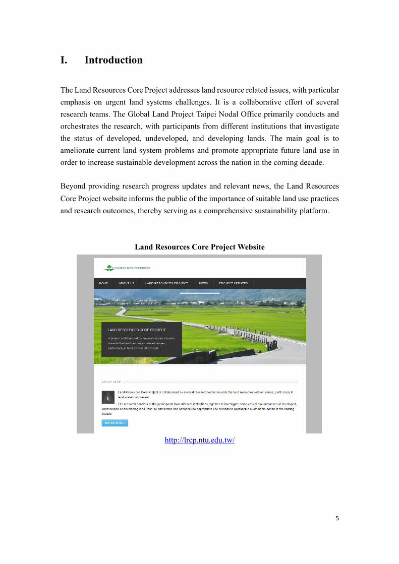
Beyond providing research progress updates and relevant news, the Land Resources
Core Project website informs the public of the importance of suitable land use practices
and research outcomes, thereby serving as a comprehensive sustainability platform.
Land Resources Core Project Website
http://lrcp.ntu.edu.tw/
6
II. The Land Resources Core Project
Project Aim and Objectives
The Future Earth, proposed in 2013, integrates important stakeholders from different
fields to foster interdisciplinary scientific research collaboration and to study earth
sustainability related issues. Nested within The Future Earth, the Global Land
Programme (GLP) advances three main themes for research that include the dynamic
changes of land systems, consequences of land system changes, and integrated analysis
and modeling for land sustainability. The GLP Taipei Nodal Office is responsible for
the research, planning, and execution of the GLP program objectives. The team is
locally based, and focuses on Taiwan land systems. The team is expected to contribute
research findings to the GLP and to maintain affiliation with The Future Earth.
In support of GLP objectives and to inform decision-making on the interrelationship
between the economy, atmospheric and climate related impacts, and inter-sectoral
governance, the Land Resources Core Project aims to: understand driving factors,
dynamic changes, and change mechanisms of Taiwan land systems. Systems analyses
on Taiwan urban, rural, slope and coastal areas will utilize land use change models to
investigate development processes, dynamic system change processes, and causal
relationships. Economic and policy priority considerations taken while developing land
use forecasting models will reflect Taiwan’s land resource resiliency for further
discussion.
Research findings will also inform as-needed revisions of the 2016 Spatial Planning
Act, which provides assessment data and planning guidance for Taiwan development
strategies. By participating in the GLP, the Land Resources Core Project promotes
Taiwan as a global model for land use change and sustainability management.
7
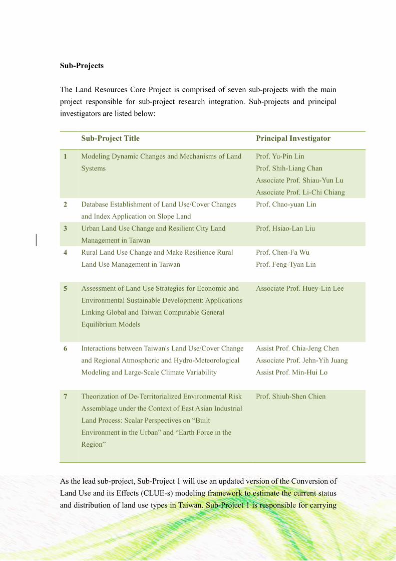
Sub-Projects
The Land Resources Core Project is comprised of seven sub-projects with the main
project responsible for sub-project research integration. Sub-projects and principal
investigators are listed below:
Sub-Project Title Principal Investigator
1 Modeling Dynamic Changes and Mechanisms of Land
Systems
Prof. Yu-Pin Lin
Prof. Shih-Liang Chan
Associate Prof. Shiau-Yun Lu
Associate Prof. Li-Chi Chiang
2 Database Establishment of Land Use/Cover Changes
and Index Application on Slope Land
Prof. Chao-yuan Lin
3 Urban Land Use Change and Resilient City Land
Management in Taiwan
Prof. Hsiao-Lan Liu
4 Rural Land Use Change and Make Resilience Rural
Land Use Management in Taiwan
Prof. Chen-Fa Wu
Prof. Feng-Tyan Lin
5 Assessment of Land Use Strategies for Economic and
Environmental Sustainable Development: Applications
Linking Global and Taiwan Computable General
Equilibrium Models
Associate Prof. Huey-Lin Lee
6 Interactions between Taiwan's Land Use/Cover Change
and Regional Atmospheric and Hydro-Meteorological
Modeling and Large-Scale Climate Variability
Assist Prof. Chia-Jeng Chen
Associate Prof. Jehn-Yih Juang
Assist Prof. Min-Hui Lo
7 Theorization of De-Territorialized Environmental Risk
Assemblage under the Context of East Asian Industrial
Land Process: Scalar Perspectives on “Built
Environment in the Urban” and “Earth Force in the
Region”
Prof. Shiuh-Shen Chien
As the lead sub-project, Sub-Project 1 will use an updated version of the Conversion of
Land Use and its Effects (CLUE-s) modeling framework to estimate the current status
and distribution of land use types in Taiwan. Sub-Project 1 is responsible for carrying
8
out detailed analysis on the dynamic changes and mechanisms of land systems,
followed by multi-scenario quantification and simulation. Sub-Projects 2, 3, 4, 5, and 6
will conduct studies on the driving factors of land use change, the causality between
the economy and land use, and interactions between the atmosphere and land use. The
research results of these subgroups will support the investigations of the lead sub-
project while the model developed by Sub-Project 1 will contribute to Sub-Projects 2,
3, 4, 5, and 6 conclusions. Predictive simulation results will be integrated into Sub-
Project 7 for qualitative environmental management and risk analysis. Consolidated
end results will be both quantitative and qualitative for resilient land use management
strategy planning and future development assessments. Sub-project abstracts are
presented in the next section.
9
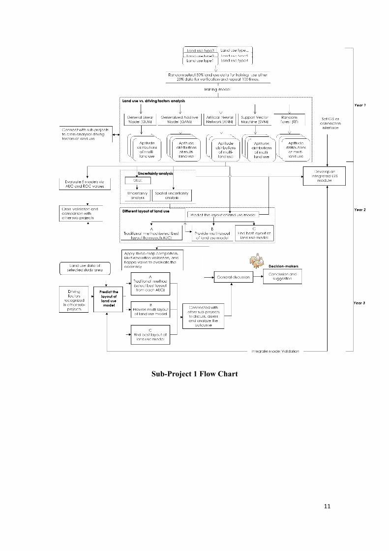
Sub-Project 1: Modeling Dynamic Changes and Mechanisms of Land
Systems
Prof. Yu-Pin Lin, Prof. Shih-Liang Chan, Associate Prof. Shiau-Yun
Lu, and Associate Prof. Li-Chi Chiang
Land use change is a spatiotemporal process that includes a large number of interrelated
natural and anthropological factors. Due to the uncertainty originating from these
factors and the complex interactions between factors, predicting future land use change
is problematic. Land use change models, however, can identify the causes and effects
of land use change. Land use planning and policy, then, is further supported when
informed by land system functional element quantification, land use type and driving
factor interaction analyses, and land use change prediction. Accordingly, this sub-
project will establish a GIS-based module to: identify the relationship between existing
land use types, analyze land use changes and driving factors, predict future land use
change, and resolve uncertainty issues from data, model parameters, and modeling
procedures. The objectives of this three-year sub-project are as follows:
Year One: Generate Taiwan land use suitability maps by identifying linear and
nonlinear relationships between land use change and predictors of change. Utilize GIS-
based land-use suitability module of five models, 1) Generalized Linear Model, 2)
Generalized Additive Model, 3) Artificial Neural Network, 4) Support Vector Machine,
and 5) Random Forest. Calculate AUC value and variations of each suitability map
generated from different land use categories and methods. Validate identified driving
factors and further discussion.
Year Two: Simulate Taiwan land use change using Conversion of Land Use and its
Effects (CLUE-s) model with different land use scenarios including, maximum AUC
value suitability map combinations, high AUC value suitability map combinations, and
greater than 0.6 AUC value suitability map combinations per land use category.
Develop GIS-based model for Bayesian uncertainty quantification.
Year Three: Identify and analyze land use change driving factors for selected land use
types within the study area, and for each sub-project. Integrate total sub-project model
data into a user-friendly GIS module.
The global impacts of coastal disasters demonstrate the high vulnerability of coastal
10
cities and the urgent demand for establishing coastal city resilience. The Taiwan island’s
critical need for a comprehensive coastal plan, is evidenced by the 2014 Coastal Zone
Management Act. Accordingly, coastal LUCC will also be examined in detail during
Sub-Project 1 execution. Specifically, modeling resilient coastal cities will identify
indicators for coastal city vulnerability calculations, and for coastal land use planning
strategies and policy development.
Sub-Project 1 is the leading edge for Taiwan participation in global land use research.
Because it is the first nationally funded research project of its kind that considers the
relationship between land use change and driving factors, as well as uncertainty analysis
based on an optimal CLUE-s model, this project will enhance the international
influence of global land use research and nurture local talent. Additionally, the GIS-
based module will be used to simulate different national land use planning scenarios to
inform decision-makers.
11
Sub-Project 1 Flow Chart
12
Sub-Project 2: Database Establishment of Land Use/Cover Changes
and Index Application on Slope Land
Prof. Chao-yuan Lin
Taiwan was once known as “Formosa” due to its plentiful forest resources. The
mountainous landscape, high species diversity, location within the East Asian Monsoon
region, along with its high annual average rainfall of 2500mm per year, have formed
Taiwan’s unique ecosystem. Under rapid population growth, limited land resources, and
to satisfy demands, however, many slopes have been transformed by continuous
development into farmland or residential areas. Because land use and/or land cover
changes can lead to environmental issues such as flooding, water pollution, and
landslides, the objectives of this three-year sub-project are as follows:
Year One: Analyze changes in land and water resources and examine the influential
factors of major disasters in watersheds.
Year Two: Establish a management model based on LUCC hot spot areas from multi-
scale perspectives, e.g., large scale (river basin), medium scale (management unit) and
small scale (cadaster and pixel levels).
Year Three: Draft a strategic plan for response to environmental change using three case
studies that evaluate the potential deep-seated landslide areas in a watershed. Identify
the optimum groundwater recharge site to counteract significant watershed subsidence,
and discuss the spatial distribution change of carbon sequestration in a watershed.
Maintain an integrated stewardship model in the watershed for conservation and
monitoring management that informs authorities.
Sub-Project 2 will analyze the multi-faceted aspects of environmental issues in a
watershed including, landslides, floods, wildfires, water resource conservation,
grassland succession, and wetland conservation by using environmental indices.
Research results will enable further exploration of LUCC driving factors and impacts.
13
Sub-Project 3: Urban Land Use Change and Resilient City Land
Management in Taiwan
Prof. Hsiao-Lan Liu
Urbanization is one of the critical factors that impact global environmental change in
the 21st century. High-density development, land use patterns, urban structures, and
consumption patterns in urban areas contribute to CO2 emissions and increasing
temperatures. In recent years, people have become aware of the severe risks that climate
change pose for our cities, particularly the threats to urban infrastructures, ecological
systems, and urban economic development. Thus, the concept of resilient cities has
gained considerable attention and interest in past few years and land use management
in and around cities should be considered when establishing a resilient city plan1. The
objectives of this three-year sub-project are as follows:
Year One: Investigate Taiwan’s urban LUCC as well as its driving forces from 1995 to
2007.
Year Two: Apply tele-connection concepts to examine the factors that influence urban
land use change in Taiwan, and how urban LUCC impacts climate change.
Year Three: Develop a resilient city land-use management strategy based on research
findings.
1 LU, P. & STEAD, D. 2013. Understanding the notion of resilience in spatial planning: a case study of Rotterdam, the Netherlands, Cities (SSCI)
14
Sub-Project 4: Rural Land Use Change and Make Resilience Rural
Land Use Management in Taiwan
Prof. Chen-Fa Wu, Prof. Feng-Tyan Lin
Rural countryside functions are essential for understanding social and land system
interactions, and are the top agenda of many international research projects. The 2015
National Land Use Planning Act provides instructions for agricultural development
planning along with relevant principles applicable to rural areas. An impact assessment
of current and successive policies, however, for an overall land use strategy assessment
will inform future policy decisions. Accordingly, this study will investigate the national
land use changes in Taiwan from 1995 to 2007, and construct a resilient land use
management model. In order to increase national support of rural countryside functions
and to synchronize our results with other international research projects and trends,
Sub-Project 4 focuses on three rural countryside functions including crop production,
countryside amenities, and ecosystem services. The objectives of this three-year sub-
project are as follows:
Year One: Investigate and discuss the national land use change processes in Taiwan and
their underlying driving forces by utilizing both a comprehensive literature review and
the project ground theory. Analyze the effect of multiple factors on land use distribution,
change, and change processes with binomial logistic regression. Quantitatively evaluate
land system dynamic change mechanisms for simulations.
Year Two: Analyze public perception of national land use and environmental change in
Taiwan. Construct a public perception questionnaire framework based on literature
review and conduct field interviews during the field questionnaire survey. Examine the
relationship between land change perception, disaster experiences, coping behaviors,
coping strategies, and strategic opportunities with Path Analysis to identify the
differences in public perception among high, medium, and low land use change areas.
Propose national land use change management strategies based on public feedback and
opinions.
Year Three: Select agricultural development areas as research sites as per the National
Land Use Planning Act intent. Simulate land use change under distinct agricultural
development resilience strategies executed with specific agricultural development area
plans. Investigate and compare the appropriateness of agricultural development areas
15
and strategies under different scenarios. Source scenario input data from complimentary
sub-project land use change simulation results. Compare land use distributions and
ecosystem services yielded under different circumstances. Assess the National Land
Use Planning Act effects on farmland recovery areas, agricultural development area
locations, and ecosystem service recovery using the reference year 1970. Discuss
proposed national land use management resilience models.
Sub-Project 4 will propose a land use management resilience model to evaluate the
effects of current land use practices and the National Land Use Planning Act. Research
experiences of the Taiwanese situation will be shared with the international community
via the Global Land Programme.
16
Sub-Project 5: Assessment of Land Use Strategies for Economic and
Environmental Sustainable Development: Applications Linking
Global and Taiwan Computable General Equilibrium Models
Associate Prof. Huey-Lin Lee
Land resources play myriad roles in human economic activities—they are key inputs
for the production of diverse goods and services and offer free ecosystem services to
support social amenities. Economic development shapes the pattern of land use change
while sustainable development of the economy and society requires well managed and
functioning land resources and ecosystem services. Following the International Council
for Science (ICSU) call for academic research on the construction of Integrated Spatial
Decision Support Systems, Sub-Project 5 will integrate economic activities and land
use change in order to conduct a systemic assessment for national land use policy.
Taiwan has become both biophysically and economically susceptible to global changes
due to a high dependency on exports while increasing economic globalization and
urbanization intensifies competition for land resources. Given the existing land
endowment system, strategic management practices take the economic efficiency and
practicality into account while reallocating land resources. Since land management
policy guides the economy towards efficient allocation land uses, and high
specialization in economic production implies that manufacturing sectors are inter-
dependent on one another, inter-industry and inter-sectoral dependencies must be
recognized when resource allocation decisions are being made. To address this, Sub-
Project 5 will develop a computable soft-linked global general equilibrium-modeling
module for Taiwan to describe the interconnection between domestic and international
consumer groups, the manufacturing sector, and resultant land use competition.
Land management policy is crucial in guiding the economy towards efficient allocation
of various land uses. The high specialization in economic production implies that
manufacturing sectors are inter-dependent on one another. Therefore, it is important to
recognize the inter-industry dependencies between sectors when resource allocation
decisions are being made.The developed module, Integrated Spatial Decision Support
System for Taiwan (ISDSS-TW), will serve as a land use policy assessment tool for
both public and private sectors. The ISDSS-TW will inform coping strategies to
simulated economic growth and land use change consequences under various scenarios,
17
including those that reflect global and national changes in the biophysical, social, and
the economic environment. The objectives of this three-year sub-project are as follows:
Year One: Develop an environmentally extended Input-Output Account with
incorporated Input-Output Tables and Taiwan Land Inventory Data. Identify the
interdependences between manufacturing sectors that contribute to the Taiwanese
economy and associated sectorial demands for land resources. Identify land use
hotspots, the “key sectors” in driving economic growth, and contributors to the
derivation of land multiplier effects for all sectors.
Year Two-Three: Identify sectors that are suitable for cooperation based on indicators
from the developed approach. Analyze various scenarios such as world trade regime
changes, global environmental changes, and domestic social and economic
development in response to exogenous and internal perturbations with the module
including economy-wide assessment model, particularly the computable general
equilibrium model. Offer insights for land management policy in the contemporary
economy of specialization.
18
Sub-Project 6: Interactions between Taiwan’s Land Use/Cover
Change, Regional Atmospheric and Hydro-Meteorological Modeling,
and Large-Scale Climate Variability
Assistant Prof. Chia-Jeng Chen, Associate Prof. Jehn-Yih Juang
Assist Prof. Min-Hui Lo
Land use/cover changes (LUCC) can affect the atmospheric, climatic, and hydrological
systems at both global and regional scales and can aggravate natural hazard events such
as flooding. Although Taiwan is committed to sustainable management, the country has
recently undergone rapid LUCC while the number of intense hydro-meteorological
disaster events per decade is increasing. In this context, Sub-Project 6 will disclose the
implicit interactions between LUCC in Taiwan and regional atmospheric and hydro-
meteorological conditions. By employing broad-spectrum analyses such as analytical,
empirical/statistical, and dynamical modeling, large-scale climate variability will also
be addressed. Separately developed research directions at distinct spatial and temporal
scales will synergistically answer the following questions:
1. Has LUCC altered local/regional weather systems (e.g., convective systems
in metropolitan areas)?
2. What is the underlying mechanism of LUCC that influences atmospheric
conditions and land-surface fluxes (and/or vice versa)?
3. Can any large-scale circulation patterns that correlate with LUCC-related
variables (e.g., temperature, precipitation, sensible and latent heat, and
vegetation index), potentially driving the long-term LUCC, be identified?
4. If it is possible to further hypothesize the influence of climate variability on
LUCC, is it possible to depict the trend and variation of those transient
atmospheric processes in the long run?
5. Is there any secondary or tertiary impact from LUCC to other environmental
systems (e.g., watershed- and metro-scale hydrology)?
Future interactions between LUCC and atmospheric dynamics under climatic change
will also be quantified in order to leverage discussion and findings regarding the above
questions. The objectives of this three-year sub-project are as follows:
Year One: Analytically and statistically analyze the relationship between LUCC and the
dynamics of thermal environment at target weather stations in Taiwan from 1950 to
19
2010. Empirically analyze (e.g., EOF, SVD, and composites) the correlation between
climate indices (i.e., teleconnections) and the LUCC-related variables at the target
stations and extended watersheds.
Year Two: Empirically analyze complimentary sub-project dynamic LUCC statistics
provided and discuss correlations between the LUCC-related variables and LUCC
statistics. Prepare offline, uncoupled simulations (with prescribed forces) on WRF,
Noah, WRF-Hydro, and SWMM to understand first-order impacts of LUCC on changes
in surface temperature, precipitation, fluxes, and hydrological responses.
Year Three: Run coupled WRF-Noah, WRF-Hydro, and WRF-SWMM simulations to
explore the relationships and underlying mechanisms between LUCC, atmospheric
convection, and hydrological responses. Integrate findings into prediction model of
future LUCC and atmospheric dynamics.
20
Sub-Project 7: Theorization of De-Territorialized Environmental
Risk Assemblage under the Context of East Asian Industrial Land
Process- a Scalar Perspective of “Built Environment in the Urban”
and “Earth Force in the Region”
Prof. Shiuh-Shen Chien
Territorialized and de-territorialized environmental risks (ERs) are important research
topics in many industrializing and industrialized countries. Existing literature, however,
mainly focuses on territorialized ERs which are geographically near to current risks in
study areas versus de-territorialized ERs which are geographically distant to current
risks via transportation mechanisms. De-territorialized ERs cannot be understood
merely through the analysis of risk materials themselves. Instead, de-territorialized ERs
are better understood as ER assemblages consisting of risk materials, risk transport
mediators, and fragmented governance of these risk materials and mediators. Sub-
Project 7 gives insights into the lesser studied de-territorialized ERs.
Categorized into at least two types of mediators, de-territorialized ERs are either: (1)
man-made transportation mechanisms such as infrastructure, and (2) natural
transportation mechanism such as wind. De-territorialized ERs are discussed in terms
of three analytical dimensions including spatiotemporal which refer to ER air column
altitudes, subterranean depths, seasonal variations, as well as the rapid dynamics
involved during explosions; ER transportation and formation mediators such as the
differences and commonalities of transformation and formation processes; and social-
spatial processes such as both built-up structures in the urban environment and the
strength of geophysical processes in regional contexts.
A theoretical framework of ER assemblages provides an opportunity to explore the
different political and social environmental scenarios, the intermediaries of ER
transmission, and the various institutional advantages and limitations of ER
management. Sub-Project 7 examines a theoretical framework of ER assemblages by
referring to two cases from Taiwan and China that have undertaken similar de-
territorialized ER management in recent years. While Taiwan possessed a more
government more accountable for its actions, China’s strong central authority can
coordinate large-scale administrative measures with or without popular consensus.
21
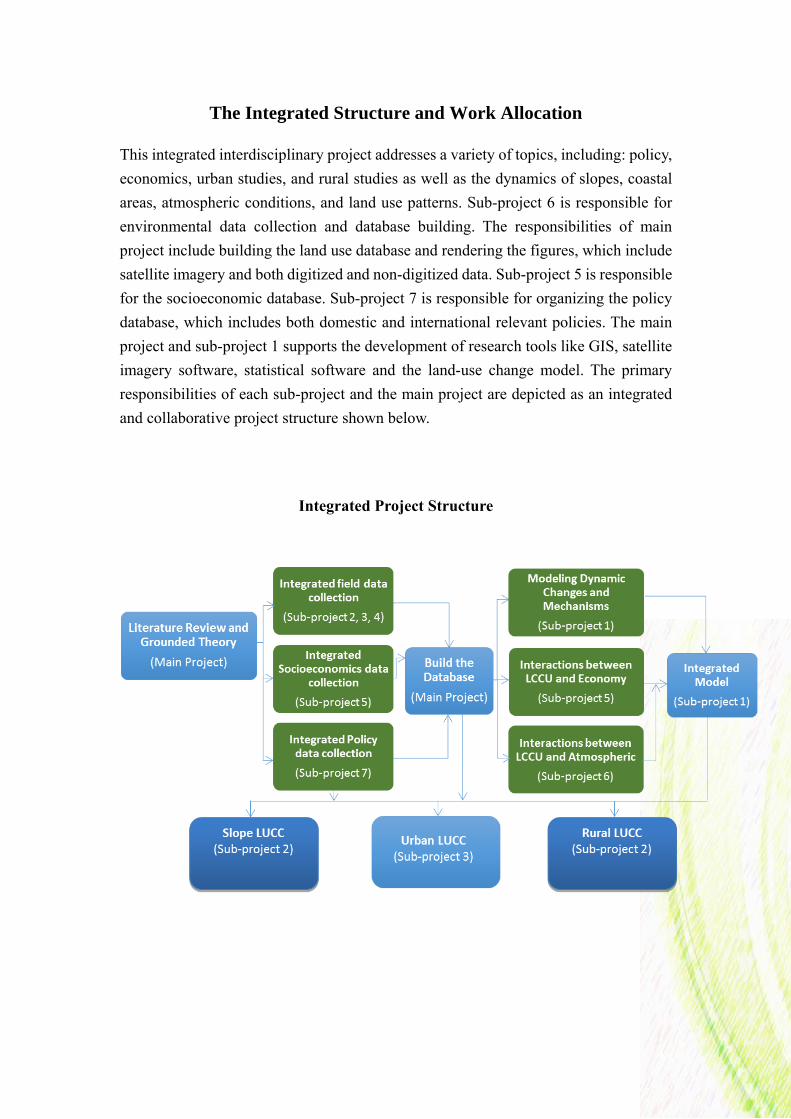
The Integrated Structure and Work Allocation
This integrated interdisciplinary project addresses a variety of topics, including: policy,
economics, urban studies, and rural studies as well as the dynamics of slopes, coastal
areas, atmospheric conditions, and land use patterns. Sub-project 6 is responsible for
environmental data collection and database building. The responsibilities of main
project include building the land use database and rendering the figures, which include
satellite imagery and both digitized and non-digitized data. Sub-project 5 is responsible
for the socioeconomic database. Sub-project 7 is responsible for organizing the policy
database, which includes both domestic and international relevant policies. The main
project and sub-project 1 supports the development of research tools like GIS, satellite
imagery software, statistical software and the land-use change model. The primary
responsibilities of each sub-project and the main project are depicted as an integrated
and collaborative project structure shown below.
Integrated Project Structure
22
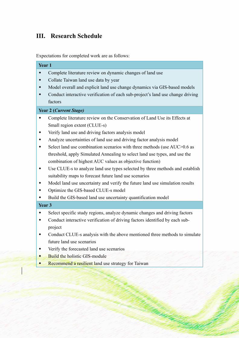
III. Research Schedule
Expectations for completed work are as follows:
Year 1
Complete literature review on dynamic changes of land use
Collate Taiwan land use data by year
Model overall and explicit land use change dynamics via GIS-based models
Conduct interactive verification of each sub-project’s land use change driving
factors
Year 2 (Current Stage)
Complete literature review on the Conservation of Land Use its Effects at
Small region extent (CLUE-s)
Verify land use and driving factors analysis model
Analyze uncertainties of land use and driving factor analysis model
Select land use combination scenarios with three methods (use AUC>0.6 as
threshold, apply Simulated Annealing to select land use types, and use the
combination of highest AUC values as objective function)
Use CLUE-s to analyze land use types selected by three methods and establish
suitability maps to forecast future land use scenarios
Model land use uncertainty and verify the future land use simulation results
Optimize the GIS-based CLUE-s model
Build the GIS-based land use uncertainty quantification model
Year 3
Select specific study regions, analyze dynamic changes and driving factors
Conduct interactive verification of driving factors identified by each sub-
project
Conduct CLUE-s analysis with the above mentioned three methods to simulate
future land use scenarios
Verify the forecasted land use scenarios
Build the holistic GIS-module
Recommend a resilient land use strategy for Taiwan
23
Conclusion
The Land Resources Core Project has completed a literature review and ground theory
study, established a database, and completed an investigation into the GIS-based land
use change model dynamics in its first year. Driving factors and various scenarios will
be examined in detail with the application of different models following the project
timeline.
Outcomes will significantly contribute to several areas, including: academia, policy
deliberation, and the international promotion of land use research. Sub-project teams
will communicate and share results at scheduled meetings, workshops, and seminars
for maximum research integration, consensus, and impact. Domestic and international
feedback on shared findings and modules will aid in formulating amendments suitable
for practical approaches.
Taiwan’s research contribution will demonstratively promote practical and sustainable
development within The Future Earth paradigm. The Global Land Programme Taipei
Nodal Office will present its findings to the GLP committee and international GLP
fellows at GLP international conferences and workshops. Shared experiences will aid
in identifying potential or emerging trends within the international community.