Embed Size (px)
Citation preview

Page 1 of 22
LANDMAP Guidance Note 5: LANDMAP and the
Geological Landscape 2016
www.naturalresourceswales.gov.uk
1 Crynodeb ..................................................................................................................... 1
2 Introduction ................................................................................................................. 2 3 LANDMAP Information ................................................................................................ 3 4 Recording the geological foundations of a landscape in LANDMAP ..................... 3
4.1 The ethos of the Geological Landscape layer ......................................................... 4
4.2 Mapping and classifying the Geological Landscape ............................................... 4
4.3 Surveying and recording the Geological Landscape ............................................... 7
4.4 Evaluating the Geological Landscape ..................................................................... 7
5 Using LANDMAP Geological Landscapes information ............................................ 9
5.1 Geodiversity ............................................................................................................ 9
5.2 Geological heritage and conservation ................................................................... 10
5.3 Sustainable Management of Natural Resources .................................................. 11
5.4 Local Development Plans ..................................................................................... 13
5.5 Protected Landscape Management Plans ............................................................ 13
5.6 Development Management ................................................................................... 14
5.7 Minerals planning .................................................................................................. 15
5.8 Renewable energy ................................................................................................ 16
5.9 River management, water supply and coastal management ................................ 17
5.10 Forestry ............................................................................................................. 17
5.11 Land reclamation ............................................................................................... 18
5.12 Geological Landscapes and land use ................................................................ 18
5.13 Local communities ............................................................................................. 19
5.14 Education and Environmental research ............................................................. 19
5.15 Cultural studies .................................................................................................. 20
6 Accessing LANDMAP Information ........................................................................... 21 7 References & Further Information ........................................................................... 21
8 Contact ....................................................................................................................... 22
1 Crynodeb
“Fel rheol daeareg sydd â rheolaeth neu sydd â’r dylanwad mwyaf ar y dirwedd, gan effeithio’n ddirfawr ar dirwedd, patrwm draeniad, a gorchudd llystyfiant. Hefyd mae’r nodweddion daearegol hyn wedi cael y dylanwad mwyaf ar ddatblygiad hanesyddol aneddiadau, drwy nodi eu potensial amaethyddol a rhwydweithiau cyfathrebu , yn
Page 2 of 22 www.naturalresourceswales.gov.uk
ogystal â mynediad i ddŵr, deunyddiau adeiladu ac adnoddau mwynau eraill.” (CNC 2016).
Mae dylanwad sylfaenol strwythur daearegol y dirwedd ar bob agwedd arall ar gymeriad y dirwedd yn gwneud haen Tirweddau Daearegol LANDMAP yn adnodd hollbwysig o safbwynt cyfarwyddo pob agwedd ar astudiaethau amgylcheddol, mewn perthynas â chynllunio gofodol a rheoli tir.
Pan fo nodweddion hollbwysig y dirwedd yn uniongyrchol gysylltiedig â’r creigwely, gall cymeriad yr ardal fod yn gymharol gadarn.
Pan fo systemau geomorffolegol ar waith, neu pan fo tirffurfiau’n cofnodi prosesau’r gorffennol, gall y nodweddion fod yn hynod fregus a sensitif i unrhyw newid. Mae systemau geomorffolegol fel y rhain, gan gynnwys rhai afonol, arfordirol a charstig, yn rheoli dosbarthiad ac iechyd nifer o gymunedau biolegol; er, yn wahanol i gymunedau biolegol, ni ellir trawsblannu nac adfer nodweddion geomorffolegol ar ôl iddynt gael eu niweidio.
Er mwyn rheoli nifer o systemau biolegol yn effeithiol, felly, mae’n hanfodol cynnal ‘iechyd’ y system ddaearegol a dylid ystyried yr haen Tirweddau Daearegol fel sail i iechyd yr haen Cynefinoedd Tirwedd. Dyma wir enghraifft o ‘Ddull yr Ecosystem’, sef cysyniad sydd bellach wedi hen ennill ei blwyf yn athroniaeth gadwraeth y DU.
Ymhellach, gall Tirweddau Daearegol gyfarwyddo ac ategu dulliau rheoli sy’n canolbwyntio ar agweddau eraill ar dirweddau sydd wedi’u mapio gan LANDMAP, yn arbennig Tirweddau Hanesyddol a Thirweddau Diwylliannol. Mae’r cysylltiadau’n cynnwys ffynonellau agregau, meini adeiladu, tystiolaeth o waith hanesyddol yn ymwneud â gwaddodion mwynau metelog, ynghyd â thirffurfiau a phrosesau sy’n gysylltiedig â datblygu aneddiadau, cyfathrebu a systemau cred. Mae cysylltiadau o’r fath yn sail i ethos y Confensiwn Tirweddau Ewropeaidd.
2 Introduction
“Geology typically controls or has the strongest of all influences on the landscape, profoundly affecting relief, drainage patterns, and vegetational cover. These geological qualities have also had one of the strongest influences on the historical development of settlements, by determining their agricultural potential and communication networks, as well as access to water, building materials and other mineral resources.” (NRW, 2016)
The fundamental influence of the geological structure of a landscape on all other aspects of landscape character makes the Geological Landscapes layer of LANDMAP a key resource for informing all aspects of environmental study both in spatial planning and land management.
Where the key features of a landscape are directly related to bedrock, the character of the area can be relatively robust.

Page 3 of 22 www.naturalresourceswales.gov.uk
Where geomorphological systems are active, or landforms record past processes, features can be remarkably delicate and sensitive to change. Geomorphological systems such as these, including fluvial, coastal and karstic, control the distribution and health of many biological communities, although unlike biological communities many geomorphological features cannot be transplanted or restored once damaged.
For the effective management of many biological systems, therefore, it is crucial that the ‘health’ of the geological system is maintained and the Geological Landscapes layer should be considered as underpinning the health of the Landscape Habitats layer. This is truly an example of the ‘Ecosystem Approach’, a concept now well established in UK conservation philosophy.
Geological Landscapes can also inform and complement management focussed on the other facets of landscape mapped by LANDMAP, especially Historic Landscapes and Cultural Landscapes. Links include sources of aggregate, building stone, evidence of the historical working of metalliferous mineral deposits as well as landforms and processes closely linked to the development of settlements, communications and belief systems. Such links underpin the ethos of the European Landscape Convention.
3 LANDMAP Information LANDMAP is a whole landscape approach that covers all landscapes, designated and non-designated, it covers natural, rural, peri-urban and urban areas, (excluding the Cities of Cardiff and Swansea) and it includes inland waters and coastal areas to the low water mark. LANDMAP is an all-Wales GIS (Geographical Information System) based landscape resource where landscape characteristics, qualities and influences on the landscape are recorded and evaluated into a nationally consistent data set. In Wales, LANDMAP is the formally adopted methodology for landscape assessment and is advocated by Planning Policy Wales. LANDMAP is comprised of five spatial datasets of information known as the Geological Landscape, Landscape Habitats, Visual & Sensory, Historic Landscape and Cultural Landscape. It is only the Geological Landscapes layer that is introduced further in this guidance note. LANDMAP Information is collected in a structured and rigorous way that is defined by the LANDMAP methodology. A GIS map shows the Aspect Areas and a survey record for each Aspect Area identified contains the descriptive landscape information; these records are linked to the GIS map. Complete, quality assured, all Wales coverage of all five layers provides a nationally consistent resource for landscape planning and decision making. LANDMAP assessments can provide the required evidence needed to inform and support criteria-based policies and plans. Criteria-based approaches fulfil the whole landscape approach of the European Landscape Convention.
4 Recording the geological foundations of a landscape in LANDMAP

Page 4 of 22 www.naturalresourceswales.gov.uk
4.1 The ethos of the Geological Landscape layer
The Geological Landscape in LANDMAP identifies the physical influences that have shaped the contemporary landscape, primarily geological and geomorphological, and identifies those landscape qualities which are linked to the control or influence exerted by bedrock, surface processes, landforms and hydrology. Geological Landscapes therefore, demonstrate the expression of an area’s geological history in its landscape, by identifying distinct components of the landscape where geology and topography are intimately linked. Such areas are distinguished as separate Aspect Areas (NRW, 2016).
4.2 Mapping and classifying the Geological Landscape Aspect Areas for Geological Landscape are defined and evaluated on the basis of their intrinsic character, typically either:
The topographic influence of the bedrock geology and its surface expression at outcrop, or
The character of the sediments present and the processes of their deposition as expressed by the topography and landforms created by such processes.
Only in cases where the geology is of high scientific value (and conservation priorities may therefore be distinct from adjacent areas), or where geological formations or deposits have a significant effect on land use (such as by determining soils rather than distinctive landforms) are the Aspect Area boundaries more geological than topographical. How Aspect Areas are derived, mapped, classified and all definitions used are detailed in the LANDMAP Methodology Geological Landscape (NRW, 2016). As with other LANDMAP Layers, the Geological Landscapes layer is organised according to a hierarchical classification system, this
Facilitates the classification of distinctive Aspect Areas within an established, repeatable framework, for example:
LANDMAP level Level 1 General landscape character
Level 2 Large-scale terrain or topography
Level 3 Medium-scale typifying terrain or topography
Level 4 Small-scale landform
Example from LANDMAP
Lowland hills and valleys
Lowland river and drainage systems
Active lowland river-flood plain system
Floodplain
Comparison to conventional geomorphological mapping
Land Region/ Landform Region
Land System/ Landform System/ Recurrent Landscape Pattern
Facet/ Facies/Land Unit
Site/Land Element / Slope Unit / Morphological Unit
Page 5 of 22 www.naturalresourceswales.gov.uk
Allows the recognition of Aspect Areas with a similar landscape character or process-related origin
Characterises, maps and reports at Level 3, defining dominant unifying character relating to a specific process or a component of a broader topographical style
Enables mapping as facets of a broader landscape, typically representing associations of landforms characteristic of a particular processes or topographic style, rather than individual small-scale landforms.
The LANDMAP classification can be used to produce thematic maps at level 3 as illustrated below, or more simplified maps at levels 2 or 1. Using information recorded in surveys, thematic maps can be produced to illustrate the location and extent of Aspect Areas. These maps can also show which Aspect Areas are associated with geological features such as rock and deposit types across Wales, or the geological age of the surface geology or deposits that give the landscape its distinctive character.

Page 6 of 22 www.naturalresourceswales.gov.uk
Figure 1 Geological Landscapes level 3 Classification
Page 7 of 22 www.naturalresourceswales.gov.uk
4.3 Surveying and recording the Geological Landscape A full description of the landscape scale geological and topographical character of the identified Aspect Areas is included within the associated survey, including:
Brief summary of the overall character
Key geological information: characteristic stratigraphical units or other rock types present, significant superficial deposits and structural features and processes - both active and past. Presence of quarries or mines, both active and disused
Geological conservation sites such as SSSIs (Sites of Special Scientific Interest) and ‘RIGS’ (Regionally Important Geological Sites).
Assessment of the current condition (e.g. from Good to Poor), Trend (e.g. from Improving to Declining) and Tolerance to Change
Existing Management and outline advice for future management
In addition to the surveys, Technical Reports are available which provide a review and synthesis of the geological and geomorphological evolution of the study area.
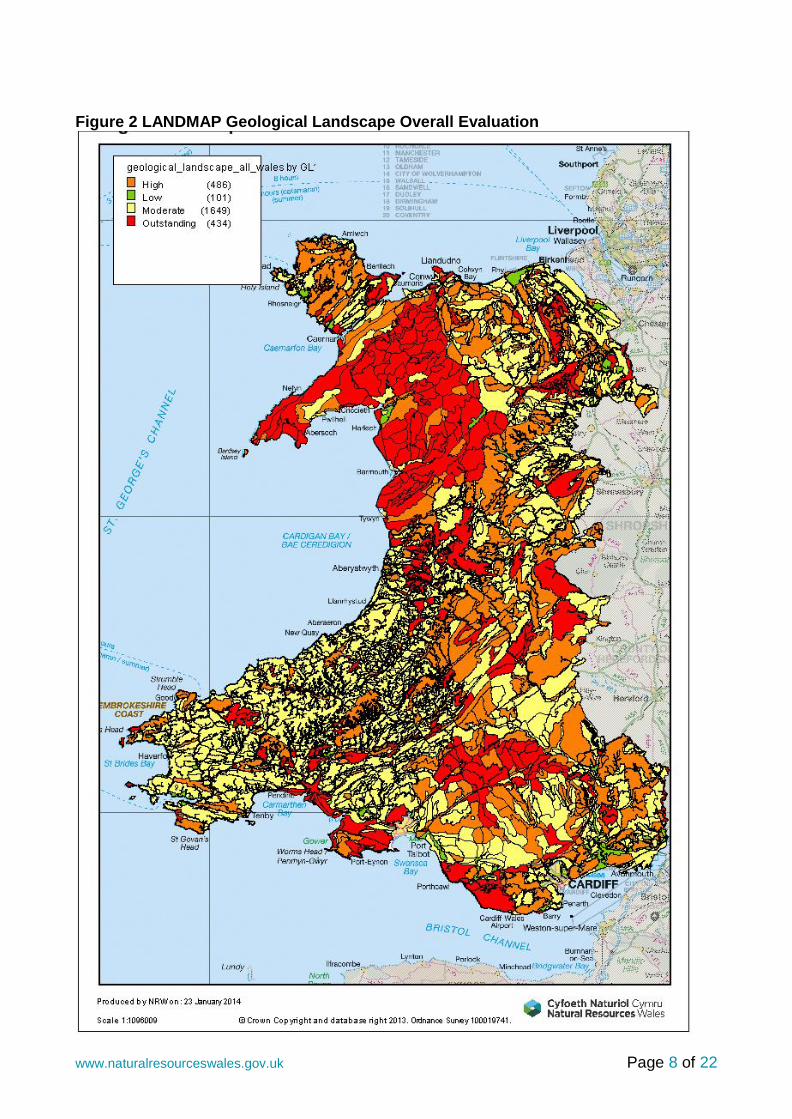
A comprehensive interactive geological time scale adapted for the UK is available from the website of the British Geological Survey, entitled the ‘BGS Geological Timechart’ 4.4 Evaluating the Geological Landscape The intrinsic value of every Aspect Area is assessed and rated on a scale from ‘Outstanding’, ‘High’, ‘Moderate’ to ‘Low’ taking into account, research value, educational value, historical value, rarity and ‘classic’ example status. An interpretation of this overall valuation for a Geological Landscape Aspect Areas is as follows:
Outstanding: The Aspect Area contains features (including sites) of outstanding Earth heritage importance, including for national and international geological science. Generally, such areas also have a high actual or potential educational value and many will also be of historical importance and contain classic, rare or unique features.
High: The Aspect Area contains features (including sites) of high regional significance for scientific studies, typically linked to a high educational potential. Some of these sites may also have some historical value or demonstrate well-developed geological or geomorphological features. Other Aspect Areas evaluated as ‘High’ form the major landscape features in a district, such as prominent escarpments and upland tracts.
Moderate: An overall rating of ‘Moderate’ is appropriate where the Aspect Area concerned is not known to include any exceptional or notable features, although it may still be ‘representative’ of its underlying geology or surface geomorphology.
Low: Aspect Areas assessed as having an overall rating of ‘Low’ have been damaged by development, or other human activities, to such an extent that the majority of features of geological or geomorphological significance have been destroyed, buried or otherwise obliterated.
Page 8 of 22 www.naturalresourceswales.gov.uk
Figure 2 LANDMAP Geological Landscape Overall Evaluation

Page 9 of 22 www.naturalresourceswales.gov.uk
5 Using LANDMAP Geological Landscapes information As the most fundamental influence on any landscape, the Geological Landscapes layer of LANDMAP can provide an essential resource for all aspects of environmental management and study. Key areas which can be developed are outlined below. 5.1 Geodiversity The term ‘geodiversity’ is now widely used to group together all the geological and geomorphological features of the natural environment which should be considered in any management and conservation programme, including both at a site and at a landscape scale.
Gray (2004) defines geodiversity as:
“The natural range (diversity) of geological (rocks, minerals, fossils), geomorphological (land form, processes) and soil features. It includes their assemblages, relationships, properties, interpretations and systems.”
‘Geodiversity’ can also be used to encompass not only geological materials and processes in a natural context, but also Earth materials removed from a natural to a cultural context, for instance to museums or used as building stones. In this context, the Geological Landscapes Aspect Layer can provide:
A valuable source for any study or inventory of an area’s geodiversity, for instance a Local Geodiversity Action Plan (‘LGAP’)
Background for the development of a comprehensive management plan for a protected area such as a National Park, AONB or Geopark.
Mapped Aspect Area boundaries which delineate a geographical area with a specific geological and geomorphological character and history.
Survey data which includes a succinct character description, details of the main geological rock units present (including their geological age) and record any geoconservation sites identified or designated at the time of the Geological Landscapes survey, and their key feature of interest. The presence of mineral workings, past and present will also be recorded (although in some areas, the lack of availability of complete records may mean that these could be under recorded). Key sources, such as British Geological Survey publications and maps, are also recorded, thus providing a baseline for further in-depth studies and assessments.
Information, which when combined with the reviews provided in the Technical Reports for each surveyed Local Authority area, can also provide a context for establishing a comprehensive national review of the key features of Welsh geodiversity at a landscape scale.
Information on the changes in the diversity and quality of Aspect Areas recorded in the Geological Landscapes layer, which will be reported as part of the Wales Environment Strategy Outcome 23: “the quality and diversity of the natural and historic character of our landscape and seascape is maintained and enhanced.”
Page 10 of 22 www.naturalresourceswales.gov.uk
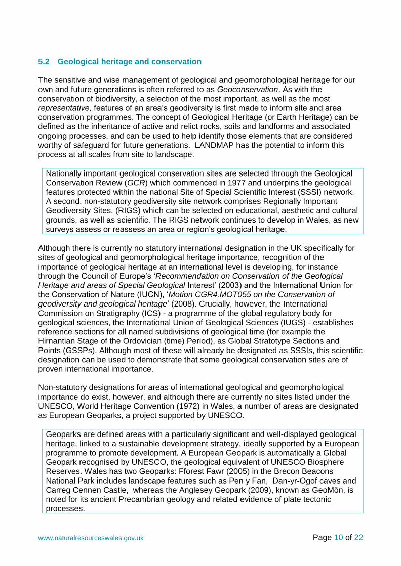
5.2 Geological heritage and conservation The sensitive and wise management of geological and geomorphological heritage for our own and future generations is often referred to as Geoconservation. As with the conservation of biodiversity, a selection of the most important, as well as the most representative, features of an area’s geodiversity is first made to inform site and area conservation programmes. The concept of Geological Heritage (or Earth Heritage) can be defined as the inheritance of active and relict rocks, soils and landforms and associated ongoing processes, and can be used to help identify those elements that are considered worthy of safeguard for future generations. LANDMAP has the potential to inform this process at all scales from site to landscape.
Nationally important geological conservation sites are selected through the Geological Conservation Review (GCR) which commenced in 1977 and underpins the geological features protected within the national Site of Special Scientific Interest (SSSI) network. A second, non-statutory geodiversity site network comprises Regionally Important Geodiversity Sites, (RIGS) which can be selected on educational, aesthetic and cultural grounds, as well as scientific. The RIGS network continues to develop in Wales, as new surveys assess or reassess an area or region’s geological heritage.
Although there is currently no statutory international designation in the UK specifically for sites of geological and geomorphological heritage importance, recognition of the importance of geological heritage at an international level is developing, for instance through the Council of Europe’s ‘Recommendation on Conservation of the Geological Heritage and areas of Special Geological Interest’ (2003) and the International Union for the Conservation of Nature (IUCN), ‘Motion CGR4.MOT055 on the Conservation of geodiversity and geological heritage’ (2008). Crucially, however, the International Commission on Stratigraphy (ICS) - a programme of the global regulatory body for geological sciences, the International Union of Geological Sciences (IUGS) - establishes reference sections for all named subdivisions of geological time (for example the Hirnantian Stage of the Ordovician (time) Period), as Global Stratotype Sections and Points (GSSPs). Although most of these will already be designated as SSSIs, this scientific designation can be used to demonstrate that some geological conservation sites are of proven international importance. Non-statutory designations for areas of international geological and geomorphological importance do exist, however, and although there are currently no sites listed under the UNESCO, World Heritage Convention (1972) in Wales, a number of areas are designated as European Geoparks, a project supported by UNESCO.
Geoparks are defined areas with a particularly significant and well-displayed geological heritage, linked to a sustainable development strategy, ideally supported by a European programme to promote development. A European Geopark is automatically a Global Geopark recognised by UNESCO, the geological equivalent of UNESCO Biosphere Reserves. Wales has two Geoparks: Fforest Fawr (2005) in the Brecon Beacons National Park includes landscape features such as Pen y Fan, Dan-yr-Ogof caves and Carreg Cennen Castle, whereas the Anglesey Geopark (2009), known as GeoMôn, is noted for its ancient Precambrian geology and related evidence of plate tectonic processes.

Page 11 of 22 www.naturalresourceswales.gov.uk
LANDMAP Aspect Areas may be evaluated as ‘Outstanding’ or ‘High’, demonstrating an international or national importance, without necessarily being formally designated. In this way LANDMAP recognises and identifies areas of major significance for geological heritage.
As the survey form for every Geological Landscapes Aspect Area records the geological conservation sites and related designations (such as Geoparks), LANDMAP can provide a useful tool for identifying sites and areas with internationally, nationally and regionally important geological and geomorphological heritage features.
In some areas, potentially significant geological and geomorphological features have also been observed as part of a Geological Landscapes area survey and these may be identified as sites or areas requiring further investigation and consideration.
5.3 Sustainable Management of Natural Resources The Environment (Wales) Bill introduces the sustainable management of natural resources (SMNR), it is how we manage natural resources to deliver sustainable development and the requirements of the Well-being and Future Generations Act by applying the ecosystem approach. The objective of sustainable management is to ensure that the way we manage and the rate of use of our natural resources, and the multiple benefits that they provide, is done in such a way that does not lead to the long-term decline of these resources and supporting ecosystems.

Page 12 of 22 www.naturalresourceswales.gov.uk
As the geological and geomorphological structure of a landscape provides the foundation for its ecology and human land use, it is fundamental to any consideration of the ecosystem approach. The Geological Landscapes layer can provide:
An important context for any consideration or characterisation of the contribution to ecosystem services through the baseline description provided.
A context for identifying links between surface geology, soil development, local hydrological conditions and the development of habitats, with their associated and characteristic species composition.
This link between geodiversity and biodiversity is well established and can form the basis for integrated bio- and geodiversity action plans, such as that established for the County of Devon, South West England, which includes guidelines for the integrated management for a wide range of habitat types.
Information relevant to the ‘Natural settings’) component of Cultural Services
Links to geodiversity, raw materials, water and physical processes components of Ecosystem Services
Information provided by the Geological Landscapes Aspect Layer, when used in conjunction with the Landscape Habitats layer, can inform a wide range of ecologically-focussed activities such as habitat management, habitat re-creation and restoration, including identifying areas potentially suitable for particular habitats and species due to appropriate bedrock, soil types, topography and landforms
A desirable scale of for delivering on landscape and catchment scale plans and projects. For example the Level 3 Aspect Areas around the Dyfi Forest near Machynlleth (see left) can inform Forest Resource Plans and the Sustainable Management of Natural Resource Planning.

Page 13 of 22 www.naturalresourceswales.gov.uk
5.4 Local Development Plans
The comprehensive, national landscape scale survey provided by LANDMAP provides a fundamental reference source and evidence base for all aspects of strategic area planning and decision making, especially in the context of Local Development Plans.
As well as identifying the geology and geomorphological processes which have created the notable landscape features which may be considered in any strategic planning, the evaluation provided by the Geological Landscapes Aspect Layer, and its objective justification, provides the evidence base to justify more restrictive land management policies.
Recommendations are made in the survey forms for each Aspect Area concerning management policies which should be implemented to help safeguard these notable features of geological and geomorphological importance.
The identification of Geological Landscapes Aspect Areas with a High or Outstanding evaluation can be used in conjunction with similarly high evaluations for other Aspect Layers for the same geographical area in order to identify sensitive landscapes of high overall value, worthy of specific planning policies, including local landscape designations. The process of identifying Special Landscape Areas is discussed further in the NRW Guidance Note.
For areas evaluated as moderate and low, the Geological Landscapes Aspect Layer can still inform forward planning, including by indicating ways in which the quality of the geological and geomorphological features of the area can be enhanced by the adoption of the specific management policies recommended within the survey forms.
An overview of the key geological and geomorphological characteristics and the geological heritage of an area (typically an administrative authority) is included in the relevant Technical Report. This information can prove invaluable for introductory sections in planning and other strategic documents.
5.5 Protected Landscape Management Plans
The term ‘Natural Beauty’, as used in the 1949 National Parks and Access to the Countryside Act, includes flora, fauna, geological and physiographic (i.e. geomorphological) features. The Geological Landscapes Aspect Layer can help identify the role and influences of geology and geomorphological processes in contributing to this Natural Beauty and the resulting character of protected landscapes, such as within National Parks (NPs) and Areas of Outstanding Natural Beauty (AONBs).
Protected landscape management plans set out the importance and vision for the protected landscape and the special qualities for which it was designated, many of which are linked to geodiversity heritage, complexity or ‘geological treasures’. As the current statutory review of protected landscape management plans requires an up-to-date evidence base, using LANDMAP information underpins the review with comprehensive information that is consistent, transparent and quality assured.

Page 14 of 22 www.naturalresourceswales.gov.uk
As these management plans set out what actions are required, LANDMAP can assist with the explanation of why a characteristic resource is important and facilitates the identification of local variability to help support the conservation of the character and distinctiveness of the area and secure locally appropriate change.
Using information from LANDMAP, monitoring can help identify and explain changes and trends which can inform a State of the National Park or AONB Report.
LANDMAP information can also help review whether the plan is responding sufficiently to landscape trends and changes, as identified in LANDMAP, or whether actions are delivering intended objectives – for instance by reviewing changes in LANDMAP descriptions, classifications or evaluations – as well as by identifying any potential implications for relevant special qualities.
5.6 Development Management
The Geological Landscapes Aspect Layer can directly inform development management. For instance, Aspect Areas that have a High or Outstanding evaluation could be potentially damaged by any development of medium to large size.
Information provided in the survey forms concerning current Condition, Threats, Trends and Management Recommendations should be consulted to help identify what types of features may be sensitive within the Aspect Area and should be taken into consideration.
For example, exposures of rock may be valued landscape features and should be retained (N.B. A rock outcrop is the presence at the Earth’s surface or immediately of a geological unit, whereas an exposure is where that rock is actually visible, either in a natural cliff or rocky crag, or artificially where any covering has been removed by human activity, for example in a quarry).
The survey forms identify all geological and geomorphological conservation sites, both statutory (i.e. SSSI) and non-statutory (i.e. RIGS), which were notified within the Aspect Area at the time of the survey. However, as RIGS surveys, in particular, may post-date the compilation of the available Geological Landscapes Aspects Layer for a given Local Authority administrative area, it is still advisable that Natural Resources Wales and/or up-to-date planning constraint mapping is also consulted.
The Geological Landscapes Aspect Layer will also identify the most significant geomorphological processes, past or present, which have been active within an Aspect Area. Where fluvial, peatland, karstic or coastal processes are particularly significant, this information can be used to assist the scoping of any Environmental Impact Assessment.
The Geological Landscapes layer can be crucial to understanding the origin of characteristic features within a landscape which is valued in a Visual and Sensory context. Similarly, Landscape and Visual Impact assessments (LVIAs) are a key part of any proposal for a medium to large scale development and use of the Geological Landscapes Aspect Layer can provide the evidence base necessary to help support or justify recommendations derived from the LVIA.

Page 15 of 22 www.naturalresourceswales.gov.uk
The identification of protected geoconservation sites and significant processes can inform any opportunities for funded positive management that might be identified through the planning process. Such activities could include the creation or maintenance of key geological exposures and features for study or educational use and ‘rescue’ operations to recover important palaeontological and mineral specimens, for instance where long term conservation of an exposure of the geological deposit might not be possible.
5.7 Minerals planning
As well as informing all aspects of strategic development control and general aspects of development control related to minerals operations (e.g. quarrying and mining), the Geological Landscapes Aspect Layer can have a particular relevance to minerals planning.
Technical Reports, typically at a County level, provide a synthesis and review of the geological history of the area and identify its key features of geological and geomorphological importance, They can, therefore, provide a valuable source for introductory sections within Minerals Local Plans, including by identifying key reference sources.
The Geological Landscape layer can help identify the key elements and features of the geology and geomorphology of a Minerals Plan area which should deserve special attention in any policy setting context, such as providing opportunities for long term conservation of geological exposures or ‘rescue’ sampling. Such policies can be informed by reference to the Management Recommendations provided for each Aspect Area within the database.
The Geological Landscapes Aspect is not suitable for mineral resource planning, however, as it demonstrates the surface expression of bedrock geology and the processes that have acted on it, rather than delineating the actual extent of workable reserves, which may be sub-surface. This information is available from geological mapping by the British Geological Survey, including specific mineral resource mapping. By identifying the broader landscape context of such workable mineral reserves, however, the Geological Landscapes layer can contribute to the development and working of such reserves, by informing Environmental Impact Assessments, including Landscape and Visual Impact Assessments.
Similarly, although the layer will not provide direct information on the presence or absence of oil or gas-containing shale bedrock – including with a potential for extraction through ‘fracking’ - it can still provide information about surface features and processes which could potentially be affected by the development and working of such resources.
The geological and geomorphological ‘highlights’ of a Geological Landscapes Aspect Area are usually its designated or notified geoconservation sites, including those of international and national importance (i.e. SSSIs) and those of regional importance (i.e. RIGS). These sites are likely to include a range of ‘fossil’ and active geomorphological interest features as well as natural and artificial exposures of bedrock (often disused quarries) and superficial deposits (i.e. ‘drift’ or Quaternary geology). Many of these

Page 16 of 22 www.naturalresourceswales.gov.uk
features can be affected by mining and quarrying processes, but not necessarily adversely. In the case of ‘static’ or relict features which represent processes no longer operative, such as glacial (or even old mine workings) and active processes, such as fluvial or karstic, the effects of continuing or new mineral operations can be highly destructive. However, where geological deposits are extensive and such features or processes are not significant, mineral operations have the potential to enhance the available geological resource for teaching or study and, consequently, complement, or even enhance, the Geological Landscapes value of an Aspect Area. This includes the creation of geological exposures which were not previous present, or by refreshing or enhancing geological features that had degraded (for instance geological exposures in old mine or quarry workings).
There may also be opportunities to fund positive management, including the enhancement of existing sites, though the minerals development process. Such positive measures should be encouraged, and can include providing improved access for visitors and educational use, for example siting rest areas and laybys close to important rock exposures or viewpoints. Any proposed works to SSSIs should, however, be first discussed with NRW.
Although such opportunities will need to be assessed on a case by case basis, reference to the Management Recommendations section of the survey form for an Aspect Area may help identify such opportunities for enhancement. Potential threats from mining or quarrying operations may also be identified in the relevant field.
5.8 Renewable energy
Wind farm developments have the potential to significantly impact the visual qualities of a landscape. In most cases, however, the effect on Geological Landscapes features is likely to be limited, as the footprint of each turbine within a larger development is relatively small and the underlying bedrock feature robust. Where features of high geomorphological values are present, however, disturbance or damage to surface features, including obscuring their viewing, can become a significant issue.
The identification of areas of High or Outstanding value can be invaluable for the initial assessment of likely effects. In cases where this significant value is linked to bedrock geology rather than surface landforms, adverse effects are unlikely. However, where the evaluation is linked to sensitive geomorphological features such glacial or periglacial landforms, there is a potential for damage and could be scoped for repositioning. Such Threats may be recorded within the survey form for the relevant Aspect Area and Management Recommendations may also be relevant. Nevertheless, the potential geomorphological impacts of each wind farm proposal should be independently assessed as part of an Environmental Impact Assessment. Aspect Area descriptions can inform this process.
’Solar Farms’ (i.e. extensive arrays of solar panels) are likely to have a significant effect on Geological Landscapes features only where sensitive geomorphological features are likely to be affected. Again, such proposals should be dealt with on a site-by-site basis, as informed by the descriptive and management fields of the survey form for the potentially affected Aspect Area.

Page 17 of 22 www.naturalresourceswales.gov.uk
Aspect Areas within the development site boundary and immediately adjacent should also be assessed, typically ranging out to 5km. Assessments should take into account any potentially significant effects on the scale and nature of the landform or landform assemblages present, skyline and landform visibility or the impact on features such as rock exposures, including access considerations. Natural Resources Wales Guidance Note 3 provides further guidance.
5.9 River management, water supply and coastal management
Although the Geological Landscapes Aspect Layer does not specifically unite all components of a river catchment, key facets of larger systems are typically identified as Aspect Areas on the basis of their overall geomorphological character. At Level 3, Geological Landscapes that are characteristic components of an active river system which can be mapped include Active Lowland River–Flood Plain System, Incised River/Stream Valley/ Ravine and Active Upland River/Stream System.
As well as identifying the different geomorphological styles of sections of a river system, areas modified or degraded by human activity may also be identified, all such information being relevant to catchment management plans and development planning of areas adjacent to river systems, especially at a landscape scale. Relevant information will be contained in the survey forms.
The Geological Landscapes Aspect Layer can provide information relevant for landscape-scale developments such as reservoirs, by identifying geomorphologically sensitive areas and systems which would be damaged or lost by reservoir construction – as well as the identification of potential areas for geological enhancement. In addition, the identification of karstic features linked to limestone bedrock may also be relevant to groundwater supply. Such information is contained in the survey forms.
Information about the characteristics of the Welsh coast, including surface geology and deposits, the identification of eroding or depositional areas as well as major coastal works is a key part of the Geological Landscapes Aspect layer. This information can supplement and inform Shoreline Management Plans, Seascape Character assessments and other coastal management programmes. Information provided for each mapped Aspect Area will also provide additional management information including in the Condition, Threats and Recommendations for Management fields. This information will also identify those areas of the coast with the highest geological and geomorphological value. This information can inform future coastal zone management planning, including helping to identify areas suitable for managed retreat.
5.10 Forestry
In a similar way to which archaeological sites can be affected, large scale commercial forestry can be extremely damaging to sensitive geological and especially geomorphological features due to the use of heavy machinery to create furrows for planting and the construction of networks of access roads. Extensive forestry cover can also obscure geomorphological features, effectively deleting their expression in a landscape. Where such developments have taken place in geomorphologically sensitive areas, it is likely that the survey form for the Aspect Area will record large scale forestry operations as an actual or potential threat to the key features of that Aspect Area.

Page 18 of 22 www.naturalresourceswales.gov.uk
Survey forms can also inform the restoration of areas where forestry has been cleared, including identifying the types of geomorphological features which may be present and could be restored or recovered. Site specific surveys would also be essential. In practice, however, if areas have already been damaged by forestry operations, there may be few or no significant, surviving features to recover.
Under certain circumstances, however, sensitive development of large scale forestry where significant geomorphological features are not present can create opportunities for enhancing the geological attributes of an Aspect Area by creating and maintain geological exposures along forest roads and in associated, small disused quarries. In some cases such exposures may already have a designated national or regional importance through designation as SSSIs or RIGS respectively. Such information will be recorded within the survey form for the Aspect Area and may also be reflected in Management Recommendations and can be used to inform future positive management.
5.11 Land reclamation
Areas of land which have previously been the site of heavy industry, including mining and quarrying, are often considered to have been ‘damaged’ and hence requiring ‘restoration’ or reclamation. However, such areas can also have a high historical and cultural value depending on the age of the former activity, and in the case of former mineral workings, may still retain features of importance to the Geological Landscapes Aspect Layer, including exposures of bedrock of at least regional importance. Under such circumstances, the ‘restoration’ of such areas to other uses such as housing or agriculture can represent a loss of significant geological heritage features.
In most cases where the reclamation of former minerals workings, especially former coal mines, is a significant risk to the character of the Geological Landscapes Aspect Area, it is recorded as a Threat in the survey form. Management recommendations are also likely to advise against the complete removal of such features which can be very characteristic of a large number of Geological Landscapes Aspect Areas, especially in South Wales. Nevertheless, as with other land management proposals, the effects on features relevant to the character of the Geological Landscapes Aspect Area should be taken into account in any site survey or Impact Assessment and appropriate measures implemented to mitigate against their loss.
5.12 Geological Landscapes and land use
Many other types of land use and management schemes can have an impact on the quality of a Geological Landscapes Aspect Area, including agriculture and aspects of species and habitat management. Changes in drainage regimes, scrub clearance or growth, deep ploughing, disposal of agricultural waste materials and habitat creation (including pond creation) have the potential to affect the geological and geomorphological features and processes that characterise a Geological Landscapes Aspect Area, either positively or negatively.
The establishment of new woodlands can obscure, even damage, sensitive geological and geomorphological sites and the excavation of ponds for wildlife in river floodplains
Page 19 of 22 www.naturalresourceswales.gov.uk
and in other geomorphological contexts can interfere with or damage geomorphological processes or landforms. Observations on the effects of current management regimes are recorded in the survey form and can inform proposals for a range of land use operations.
5.13 Local communities
The Geological Landscapes layer can be invaluable for identifying the fundamental qualities and geological resources of a landscape that have influenced the development of past and present settlements. Such links include agricultural potential linked to the soil types that a particular bedrock or surface deposit can form, the defensive potential of particular landforms, potential communication routes such as mountain passes as well as access to water supplies (including underground), building materials and other mineral resources. In many cases there may also be a link to cultural development and even belief systems.
As a review and characterisation of the underlying geological structure of a landscape and its long evolution, the Geological Landscapes layer can reveal a wealth of information for communities, especially in rural areas, interested in understanding the origins of the landscape features around them. In combination with the Landscape Habitats, Historical Landscapes and Cultural Landscapes aspect layers, this information provides an invaluable way in which such communities can understand their origins and develop a comprehensive sense of place, thereby informing local projects and activities. Such projects could include heritage days, self-guided trails, conservation projects and displays informing about, celebrating, or even managing valued aspects of the local area’s natural and cultural heritage. In the latter context, the establishment of a Local Geodiversity Action Plan may be an appropriate activity.
Relevant information is included in the summary descriptions for each identified and mapped Aspect Area, as supported by sections in the Description, including recording rock or deposit type and their geological age and the presence of geoconservation sites.
Communities could actively develop their local geological heritage for educational and tourism projects and awareness raising. Interpretation boards could showcase geodiversity information and explain the links between local geodiversity and cultural and natural heritage.
5.14 Education and Environmental research
In a similar way to which the Geological Landscapes layer can inform local communities and provide source material for activities such as conservation and heritage projects, the same materials can also inform activities in the context of formal education, for instance in primary and secondary schools. It can also be used in conjunction with the British Geological Survey’s ‘Make-a–Map’ to give more local detail, as well as for familiarisation purposes before groups make use of the ‘outdoor classroom’.
The Geological Landscapes layer offers a resource through which the key physical features which have created the landscape visible today can be identified, including the nature of local geological materials and evidence of climate change in the landforms
Page 20 of 22 www.naturalresourceswales.gov.uk
present - thus informing Science and Geography teaching and student project work at all levels from primary school to university.
Listings of geological conservation sites, including RIGS - which are often selected for their educational value - can also inform fieldwork planning. Questions 29a (‘Research value’), 29b (‘Educational value’) and 32 (‘Classic example’) can all be used to give an indication of most the suitable areas for such studies. Condition, Trend and Management fields, including Recommendations for Future Management, can also inform studies investigating environmental condition and management.
In addition, with over 480 Geological Conservation Review sites forming the basis of the SSSI network in Wales, as well as a developing RIGs infrastructure, it is not surprising that the country attracts geological groups and researchers from universities all over the world. Listings of key bibliographic sources for each Aspect Area in the survey forms, as well as of geoconservation SSSIs and RIGS, can be invaluable as a starting point for any such visit or study, especially if used in conjunction with additional information provided by the applicable Technical Report. In addition, as a source of information on the fundamental natural structure and origins of all Welsh landscapes, this same information can be used in conjunction with other LANDMAP layers to inform a wide range of other environmental studies. It should be noted, however, that such listings will only be complete to the date of the particular Geological Landscape survey being used, as new sites may have been subsequently notified.
Using LANDMAP at levels 1, 2 or 3 can also serve as a framework or context for broader, for instance national scale, studies.
5.15 Cultural studies
Used in conjunction with the Historical and Cultural Landscapes layers, the Geological Landscapes layer can help identify the fundamental qualities of a landscape that have influenced the development of human settlements and related cultural attributes such as belief systems and artistic inspiration. It can also assist in explaining ‘integrity’ and ‘unity’ in the Visual and Sensory layer where building materials are an important local component.
At a more resource-focussed level, however, links to local sources of walling and building stone, which can strongly influence vernacular architecture, and major mineral resources which have very strongly influenced the development of local communities and culture, such as slate and coal, means that the Geological Landscape locally has very strong links to the Cultural Landscapes layer.
In certain key cases, the geological resource underpins the highest level of global celebration of cultural heritage, in the form of UNESCO listed World Heritage sites. Key examples in Wales are the Blaenavon World Heritage Site in South Wales which is linked to iron ore working and processing, and the world famous Slate Industry of North Wales, which is being placed on the tentative list for the UKs World Heritage Site nominations.
Even within the more urban, built environment of towns and cities, aspects of the Geological Landscape are still relevant, including as remnants of the primary

Page 21 of 22 www.naturalresourceswales.gov.uk
geomorphology of the region which have influenced or even controlled the original siting of the settlement, and may also be reflected in the buildings, roads and other structures constructed from materials derived from a geological resource which is often still local.
6 Accessing LANDMAP Information All quality assured LANDMAP Information is available by viewing the information in the interactive map or by downloading the information onto your computer for use in a Geographical Information System (GIS). Further information is available from http://www.naturalresources.wales/landmap?lang=en
7 References & Further Information British Geological Survey 2001. Building Stone Resources Map of Britain (compiled by Lott, G.K.). Council of Europe ‘Recommendation on Conservation of the Geological Heritage and areas of Special Geological Interest’ (2003) Devon Biodiversity Partnership 1988 (updated 2009). The Nature of Devon: A Biodiversity Action Plan. Devon County Council. Downing, R.K. and Newsome, D. (eds) 2005. Geotourism. Elsevier, Oxford. English Nature 2004. Linking Geology and biodiversity. English Nature Research Report 562. English Nature, Peterborough. Ellis, N.V. (ed.), Bowen, D.Q., Campbell, S., Knill, J.L., McKirdy, A.P., Prosser, C.D., Vincent, M.A. and Wilson, R.C.L. 1996. An introduction to the Geological Conservation Review. Geological Conservation Review Series 1. Joint Nature Conservation Committee, Peterborough, 131pp. Gray, M. 2004. Geodiversity: Valuing and conserving abiotic nature. Wiley, Chichester: 434pp. (second edition 2013) Humphries, R.N. and Donelly, L. 2004.Geological conservation benefits for biodiversity. English Nature Research Report 561. English Nature, Peterborough. International Union for the Conservation of Nature (International Union for the Conservation of Nature), ‘Motion CGR4.MOT055 on the Conservation of geodiversity and geological heritage’ (2008) Natural Resources Wales (2016) LANDMAP Methodology Geological Landscape Natural Resources Wales (2016) LANDMAP and Landscape and Visual Impact Assessment for onshore wind turbines. LANDMAP Guidance Note 3

Page 22 of 22 www.naturalresourceswales.gov.uk
Natural Resources Wales (2016) LANDMAP and Special landscape Areas. LANDMAP Guidance Note 1 Page, K.N., Keene, P., Edmonds, R.P.H. and Hose, T.A. 1996. Earth Heritage Site Interpretation in England: a review of principle techniques with case studies. English Nature Research Report 176: 52pp. English Nature, Peterborough Prosser, C., Murphy, M. and Larwood, J. 2006. Geological Conservation – a guide to good practice. English Nature, Peterborough, 145pp Scottish Natural Heritage 2008. Scottish Fossil Code. Scottish Natural Heritage, Edinburgh Town & Country Planning, England and Wales (1999) Town and Country Planning (Environmental Impact Assessment) Regulations 1999, HMSO Welsh Government (2012) Planning Policy Wales Edition 5 Welsh Government (2012) Sustaining a Living Wales, Green Paper Wallingford, H.R. 1991. A Guide to the Selection of Appropriate Coast Protection Works for Geological SSSIs, Hydraulics Research and Nature Conservancy Council, 34 pp. Wimbledon. W.A.., Ischenko, A.., Gerasimov, N.P., Karis ,L.O., Suominen, V., Johansson, C.E. and Freden, C. 2000. Geosites – An IUGS initiative: Science supported by Conservation. In: Barettinno, D., Wimbledon, W. A. P. and Gallego, E. (eds). Geological Heritage: It’s conservation and management: 69-94. Instituto Technológico GeoMinero de España, Madrid. Wimbledon, W.A.P., Benton, M. J., Bevins, R.E., Black. G. P., Bridgland, D. R., Cleal, C. J., Cooper, R G. and May, V.J. 1995. The development of a methodology for the selection of British sites for conservation. Part 1. Modern Geology 20: 159-202.
8 Contact Jill Bullen Senior Landscape Specialist Natural Resources Wales Rhodfa Padarn, Llanbadarn Fawr Aberystwyth, SY23 3UE email: [email protected]