Embed Size (px)
Citation preview
AD-A141 673 GEOSAT OCEAN APPLICATIONS PROGRAM (GOAP INITIAL DATA 1/1PROCESSINO AND ANAL-U NAVAL OCEAN RESEARCH ANDDEVELOPMENT ACTIVITY NSTL STATION MS.. M LYBANON
UNCLASSIFIED APR 84 NORDA-TN-270 F/G 8/3 NL
mEEEEEEElllllI
mnsoon"I iIIII-- i
. ... - l1
L6.'.
LL
1I.8111IL125 jQ1.4
MICROCOPY RESOLUTION TEST CHARTNATIONAL BREAU Of STANDARDS-1963-P.
j UORWU Thld 1t 276hW kmekt
GEOSAT Ocean Appications Program (60WP)g I~nilal Data Processing and Analyss SystemI Test and Evaluation Plan
I -W SATELLTE ORBITq~J.0
I (I IONOSPNERlC PROPMATIOI ERROR1 0 SATELLITE ALTIMETER
MASUREMENT hfr)arMOUPHRic PwROATadi
ERROR
OCEAN SURFACE
MAII
ILIPI EL~~LPSOT
Matw LYbam MAY3 0 M
ppovw for Pw Rol" Remote Sensing Bac0"~ ~mfd OeanSeningand Predicton Division
Ocea ScinceDirectorate
Ap" 19114
VAW - -
II]T
ABSTRACT
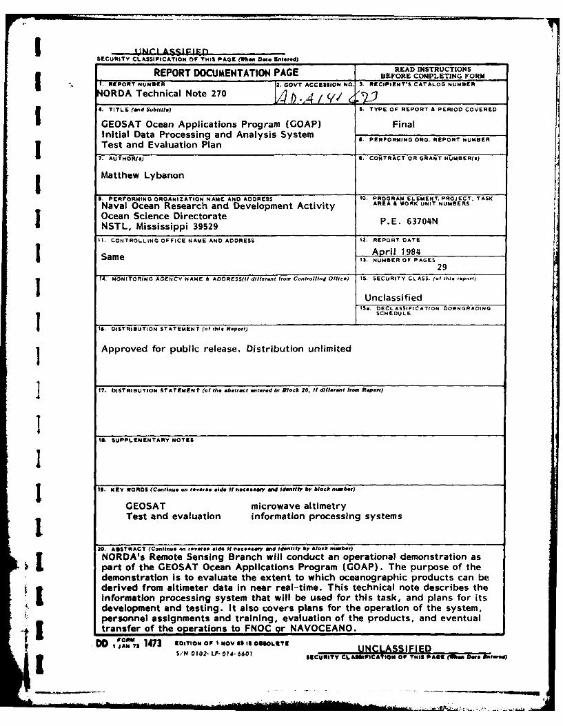
NORDA's Remote Sensing Branch will conduct an oper-ational demonstration as part of the GEOSAT OceanApplications Program (GOAP). The purpose of the demon-stration is to evaluate the extent to which oceano-graphic products can be derived from altimeter data innear real-time. This technical note describes theinformation processing system that will be used forthis task, and plans for its development and testing.It also covers plans for the operation of the system,personnel assignments and training, evaluation of theproducts, and eventual transfer of the operations toFNOC or NAVOCEANO.
Ac'cession For
NTIS GRA&IDYIC TAB 0uz:nonced 0
ByJstifibution/
AvailabilitY Oodes.iAvail and/or
Dist 5picial
,I:l l_ i I i

ACKNOWLEDGMENTS
The preparation of this technical note was part of thework performed for the Satellite Oceanography TacticalApplications (SOTA) Program, under Program Element63704N. Sponsorship was provided by CAPT D. C.Honhart, CNO/OP-952D. The SOTA Program is managed byMr. A. E. Pressman, NORDA Code 321. Coordination ofthe GEOSAT Ocean Applications Program (GOAP) is pro-vided by CDR 0. R. McConathy, NAVELEX POE 106-48. Thework was performed during the period May-August 1983and January-March 1984.
ii
4~. - -f
IGEOSAT OCEAN APPLICATIONS PROGRAM (GOAP) INITIAL DATA PROCESSINGIAND ANALYSIS SYSTEM TEST AND EVALUATION PLAN
1. INTRODUCTION
1.1 PURPOSE OF TEST PLAN
IThis test plan has been prepared in order to doucment the Navy GEOSAT Programadvanced development (6.3) activities that will be performed by the Naval OceanResearch and Development Activity (NORDA) Remote Sensing Branch, It is written:
e To provide an overview of the GEOSAT Ocean Applications Program (GOAP) infor-mation processing and a description of the hardware and software that will be used.
* To present an orderly schedule of events, specification of organizationalrequirements, method of testing, and a schedule of user orientation.
e To establish a comprehensive test plan and to communicate the nature and* extent of the tests deemed necessary to provide a basis for evaluation of the
system.
* To describe the demonstration products and their ingredients.
* To describe the demonstration telecommunication system.
* To describe the field verification activities.
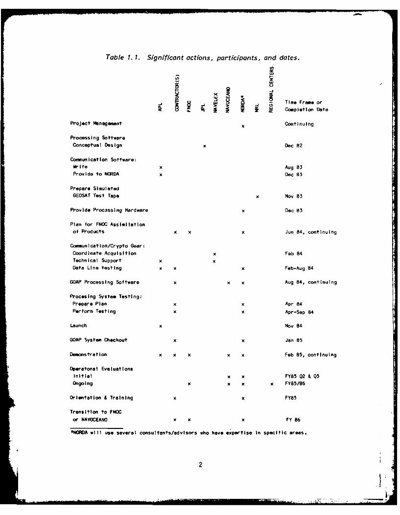
1.2 ORGANIZATIONAL INVOLVEMENT
Table 1.1 is a matrix that shows action organizations, actions that have been,or will be performed, and time frames.
" 2. DEVELOPMENT TEST ACTIVITY
2.1 BACKGROUND
NORDA, under separate funding, is developing a satellite receiving/processingfacility. That processing facility has been upgraded to support GOAP by the purchaseof two Gould SEL 32/27 32-bit minicomputers with associated peripherals. Table 2.1lists the hardware and system software for the upgraded satellite processingfacility.
As part of the GOAP program, NORDA is also supporting the development of theGEOSAT oceanographic information processing system. Four stages are involved in thedevelopment of the system: planning, implementation, demonstration and evaluation,and the operation phase. The developmental study for the information processingsystem took into account hardware/software and software/software interfaces, data
*queues, and data processing. A Conceptual Design Review was held in October 1982.The Critical Design Review for the APL/NORDA telecommunications link was held in May1983.
I
Rii
Table 1. 1. Significant actions, participants, and dates.
--d Time Frame or
Cplet
Project Management Continuing
Processing SoftwareConceptual Design x Dec 82
Communication Software:Write x Aug 83Provide to NORDA x Dec 83
Prepare SimulatedGEOSAT Test Tape x Nov 83
Provide Proc3ssing Hardware x Dec 83
Plan for FNOC Assimilation
of Products x x x Jun 84, continuing
Communlcatlon/Crypto Gear:Coordinate Acquisition x Feb 84
Technical Support x x
Data Line testing x x x Feb-Aug 84
GOAP Processing Software x x x Aug 84, continuing
Procesing System Testing:
Prepare Plan x x Apr 84
Perform Testing x x Apr-Sep 84
Launch x Nov 84
GOAP System Checkout x x Jan 85
Demonstration x x x x x Feb 85, continuing
Operatonal Evaluations
Initial x x FY85 Q2 & Q3Ongoing x x x x FY85/86
Orientation & Training X x FY85
Transition to FNOC
or NAVOCEANO x x x FY 86
*NORDA will use several consultants/advisors who have expertise in specific areas.
.1'
Table 2. 1. NORDA satellite processing facility system components.
Item No. Qty. Model No. Description
13428 SEL 32/27 with 2 MB MOS memory, CPU with
tloating point, U0P, 10 Sel BUS + 5 MP B3US slot,
2 1 3901 SEL 32/27 CPU Cabinet
3 1 3443 SEL 32/2750 with 2 MB MOS memory, CPU with floating
point, lOP, 18 SeIBUS + 8 MP BUS slots[
4 1 3902 SEL 32/2750 CPU Cabinet
5 2 8610-2 Console CRT
6 3 9131 HSD Interfaces
7 1 9135 lntercomputer Bus Lino - 501 Cable
8 2 8511 8 Line Asynchronous Mux
9 2 8580 RS 232 Distribution Panel for 8511
10 2 8140 Single 300 MByte disc with controller
11 1 8212 Single 125 IPS - 800/1600/6250 BPI tape di~vewith high speed control ler
12 1 8290 High Speed Meg Tape Cabinet
13 1 1401-0201 MPX Version 2.1 A Op0erating System
14 1 141 1-0201 Scientific Runtime Library
15 1 1413-0201 Fortran 77+
After launch of GEOSAT in early FY-85, the hardware and software system will beused in an operational demonstration, which is intended to evaluate the extent towhich oceanographic products can be derived from altimeter data in near real-time.The first 12-18 months of the demonstration will be conducted at NORDA; subse-quently, the responsibility for conduct of the demonstration will be transferred toeither Fleet Numerical Oceanography Center (FNOC) or the Naval Oceanographic Office(NAVOCEANO) in accordance with Reference 20.
Several organizations and locations are involved in the operational demonstra-tion and the preparation for it. The GEOSAT satellite will be built by the JohnsHopkins University Applied Physics Laboratory (APL); the ground receiving site willbe at APL. APL will perform some preliminary data processing and transmit theresults to NORDA. (Satellite data dumps will occur about once every 12 hours. Some-times, partial dumps may occur on consecutive passes.) NORDA will analyze the datato provide wind and wave information over open ocean areas as soon as possible afterreceipt of the data from APL, seven days per week, ice edge location every 24 hours,and information on mesoscale ocean features in selected areas every 24 hours, fivedays per week. The calculations will require oceanographic fields and other oceano-graphic data to be transmitted from FNOC to NORDA. The results of the analysis willbe transmitted from NORDA to FNOC according to the schedule given above. Both APLand Jet Propulsion Laboratory (JPL) were under contract to NORDA in FY-82 and FY-83to help prepare for this operational demonstration. The two laboratories have uniquecapabilities in complementary aspects of the problem. NRL is also providing assist-ance in sensor performance validation and similar areas. Computer Sciences Corpora-tion (CSC), the on-site contractor, will provide support in detailed software designand implementation, and in implementation of data link hardware and software. NORDAwill manage the GOAP information processing system development, supported by severaladvisors/consultants. NAVELEX is providing overall management coordination for GOAP.
2.2 PRETEST ACTIVIY
2.2.1 Data Links
APL will transmit to NORDA a "NORDA Data Record" (NDR), which will be a datastream that consists of a header frame and multiple data frames [13]. The NDR willbe encrypted and transmitted to NORDA via a new 9.6 kb/s communication line. Encryp-tion is required because the raw altimeter height words will be classified SECRET.At NORDA the data stream must be decrypted and input to the SEL 32/2750 computersystem via an interface unit. A similar link will be required to transmit productsfrom NORDA to FNOC; the mesoscale product will also be SECRET. NORDA must alsoreceive FNOC fields, such as EOTS analysis results. That data volume is low comparedto the GEOSAT data. Encryption/decryption are not required for fields such assurface temperature and pressure, and surface water vapor pressure, but will berequired for BT data. A new dedicated communication line will be used for NORDA-FNOCcommunication.
Hardware and software compatibility between the different sites is important.APL has procured the following SEL interface hardware to support the APL-NORDA GOAPcommunications link: Model 9116 Binary Synchronous Line Interface Module (2 needed),Model 9103 General Purpose Multiplexer Controller, and Model 9305 General PurposeDevice Controller Chassis. NORDA has purchased similar equipment. The data linebetween APL and NORDA will be specified to have technical performance equivalent toDataphone Digital Service (DDS). Other communication link hardware required includesmodems (provided with data line) and encryption/decryption gear (to be provided
4
I|
GFE). APL has written the communication and file management software and provided itto NORDA. The transmission protocol will be (IBM standard) binary synchronous.
FNOC is in the process of converting to the Advanced Data Communication ControlProcedures (ADCCP) communication protocol, which is the American National StandardsInstitute (ANSI) bit-oriented data link control procedure standard. ADCCP is aderivative of the International Standards Organization's (ISO) high-level data linkcontrol (HDLC) protocol. The communications software available for SEL computersuses as a basic link control procedure the Link Access Procedure B (LAPB) of X.251980, as recommended by the Consultative Committee for International Telephony andTelegraphy (CCITT). It corresponds to the asynchronous balanced mode subset of HDLC.FNOC has suggested that they could use a PDP-11/34 computer for which an off-the-shelf X.25 communications package is available. The hardware interface to theNORDA computer will be the SEL Model 8520 Synchronous Communications Multiplexer(SCM). The associated SEL software is the Advanced Communication Executive (ACX-32)Level 2. The communication line will be specified to have C4 conditioning.
2.2.2 NORDA Satellite Receiving Facility and GOAP Data System
The NORDA RFP for a turnkey satellite receiving system was modified to specifythat the processors used in the system would be two (GFE) Gould SEL 32/27 32-bitminicomputers, with one allociated for use by GOAP. That processor became available Vfor use in December 1983.
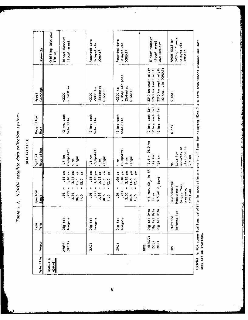
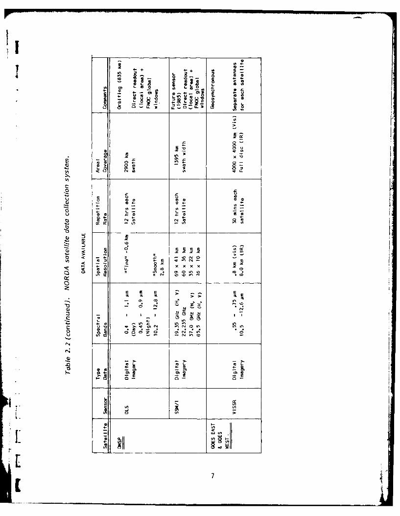
The two Gould SEL 32/27 computers and associated peripherals and software, asdescribed in Table 2.1, will upgrade the NORDA satellite processing facility toenable it to support GOAP and other NORDA research efforts. Additionally, GOAP willmake use of satellite IR imagery obtained via the satellite receiving facility.Table 2.2 lists details of the satellite imagery that will be available from NORDA'sfacility.
The previously described data links and the NORDA satellite receiving/process-ing facility are important elements in the GOAP information processing system. Otherelements are the software modules that will process the information at NORDA. NORDAand its contractor(s) will design the software system to run on the NORDA GOAP com-puter. Plans for the APL GOAP software and its testing are described in the GEOSAT-AOcean Applications Program APL/NORDA Data Link Program Plan [1]. More details on theNDR are given in Reference 13.
JPL's preliminary system-level plan for information processing development [2]addresses two primary and two secondary functional requirements. The primaryrequirements are:
9 Provide wind and wave reports approximately every 12 hours to FNOC. Windspeed and significant wave height will be contained in the NDR and can be passed onwith only minor processing (editing and averaging). This is consistent with FNOC'stimeliness requirements for the data. In cases when only a portion of a 12-hourperiod of data is dumped from the satellite and transmitted to NORDA, the available
*data (likely to be from the most recent time period) will be forwarded to FNOCwithout waiting for the remainder.
e Provide a mesoscale oceanography analysis for selected areas every 24 hours' to FNOC. Current plans call for NORDA to develop the methodology to interpret the
"mesoscale analysis in order to provide an Expanded Ocean Thermal Structure (EOTS)bogus file; this capability will be ready in the FY-86/87 time frame.
5[I
4- 4-0
0) 04- 4- 0 M0 4c001 00 to to a10 10
-0 -; 1001 Cl) LL0 L~ -C JuLn 0) (n0 U. >-
v- .0. '00 0 0V0- -ou1 (A 'n o U)
C~~~~4 'A ._ _ _ _ _
4- 4-4--
10 10110
0 4 4-V iniE
0 22 to-m 00 0 to 0 .
10 O4%0 N 0 -.0 N 0000 .0N NUi CN N( -
-Cx x -C C1 X-C4 N NN C
U, CU) 0,
0 (O 0 0 00
CL4 -4- 4-0) 10 N40ci10 N O C N 0)
o -a N
4. ~---0 %- 4E00 M2 - 00 F
4-0 El 0 10c ItoM4- 4
a,~ ID (n. '01w Ln u n'o wr
0
E E EE E0 2 E2EE2EE 2 La to
ODl' In~ V 0
4-N to 4-
- rI n I I % n I I rI I Ir nI 0 A
0 c 0. o - COD 4-IV >~' .0 ~ ' -~ .N >00 L4-
4- (D 4-- (D440 0 0 10
- - - 04
10 L) 1000A CA )<4-
10 ) - -~---4- 0
0- O- V- 00 0-
0 -
4-I
4- + to2 c
8 0
L4- 0 g
5L' CA3 x .
43. LQ 0'3cS,
-0 4--
Q 1*to4-~ -
(D 0 r(ON
0 . 27 0'oL (w
a~ c- 0'0
E EX E
N 4
-24
4- (AUl
CL I7 cmi[O
* A recently-added requirement (not addressed in the JPL plan) is for sea iceedge location daily on a near-real-time basis. Reference 10 requests and Reference14 validates the requirement for this product. The information will be provided toFNOC, which will incorporate it into the ice product that they prepare for NavalPolar Oceanography Center, or prepare an independent plot. New FNOC software may berequired for this purpose.
The secondary requirements are:
* Provide the capability to evaluate, and then enhance, the data productsduring the demonstration and evaluation phase.
e Provide the capability to determine system performance and assist in problemisolation in the complete end-to-end system (interface to mainline GEOSAT program,GOAP data processing system, FNOC data processing system, and the communicationslines). This system will form the baseline for the N-ROSS (Navy Remote Ocean SensingSystem) altimeter processing.
These functional requirements translate into requirements for several types ofresources and capabilities:
e Interactive data recall, display, and manipulation capabilities.
e Software development tools and resources
* Supporting data types such as composite infrared contour maps, bathy-thermograph data, and FNOC fields (e.g., EOTS analysis results).
There are significant problems associated with the preparation of a dailymesoscale product. The altimeter will be nadir-looking with a "swath" only a few km(depending on sea state) wide. The ground track pattern that will be laid down overa six-month period will provide several "cuts" through an area the size of even asmall eddy located anywhere on the globe (between 720N and 720S, the limits ofcoverage by GEOSAT). However, the slow fill-in and other characteristics of thetrack laydown will cause severe sampling problems. In particular, the cross-tracksampling of a moving feature will be severely distorted. Also, long periods (oforder months) may elapse during which a mesoscale feature may be missed entirely.This last problem, in particular, conflicts with the requirement for a dailymesoscale product. These points are discussed in more detail by Mitchell [15].
The analysis approach that NORDA will employ is interactive image processing. Ahuman analyst will view altimeter height residuals, in plan and profile form, alongwith other information (e.g., satellite infrared imagery, bathymetry, XBT observa-tions) and make subjective decisions about the mesoscale feature content revealed bythe ensemble of data. NORDA supports the development of objective techniques todetect and monitor the desired feature types, but the interactive approach providesthe best "payoff" potential in the time available for development.
FNOC has tasked NORDA (Code 322) to develop several techniques in connectionwith the FNOC Optimum Thermal Interpolation System (OTIS). Among these is arecommendation of the best approach for objective assimilation of GEOSAT altimetry
* data into OTIS, and the initial design of software necessary to implement thisrecommendati on.
8
9.
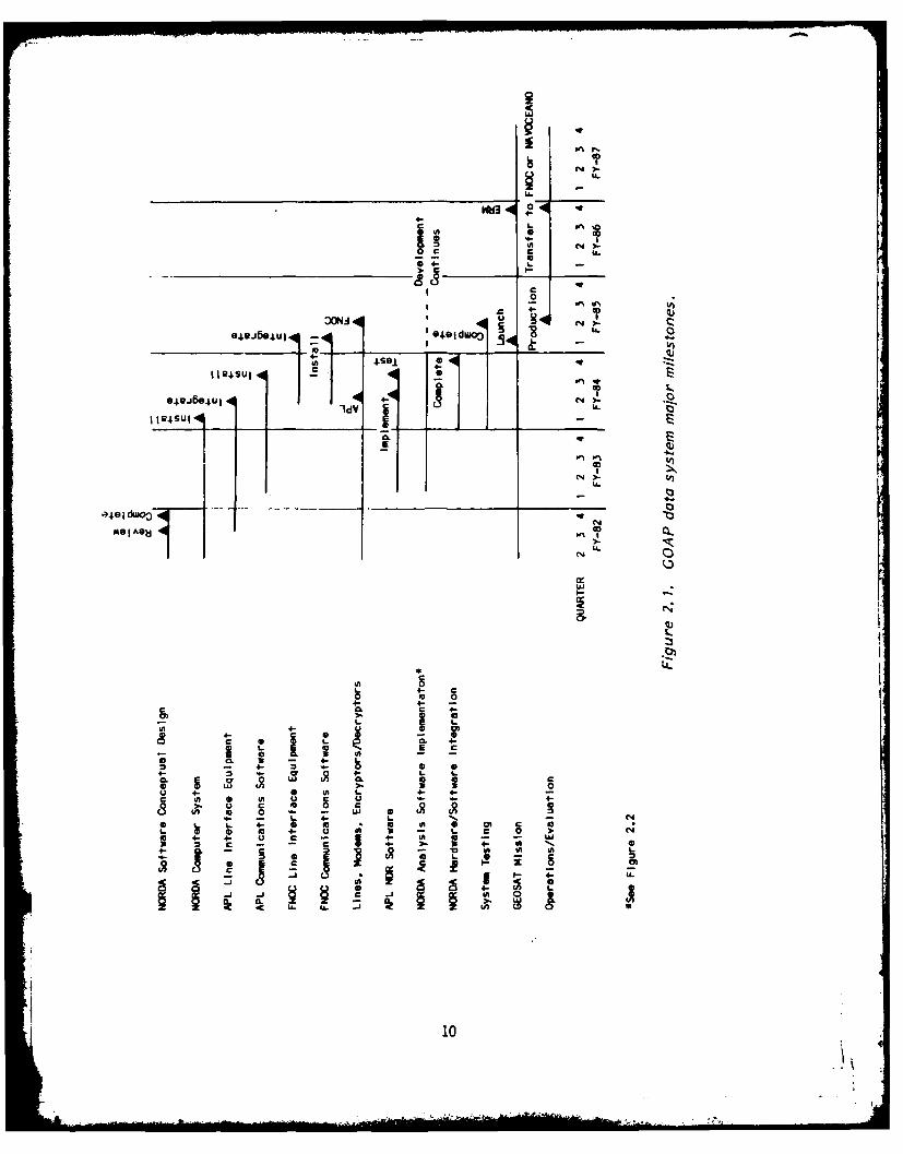
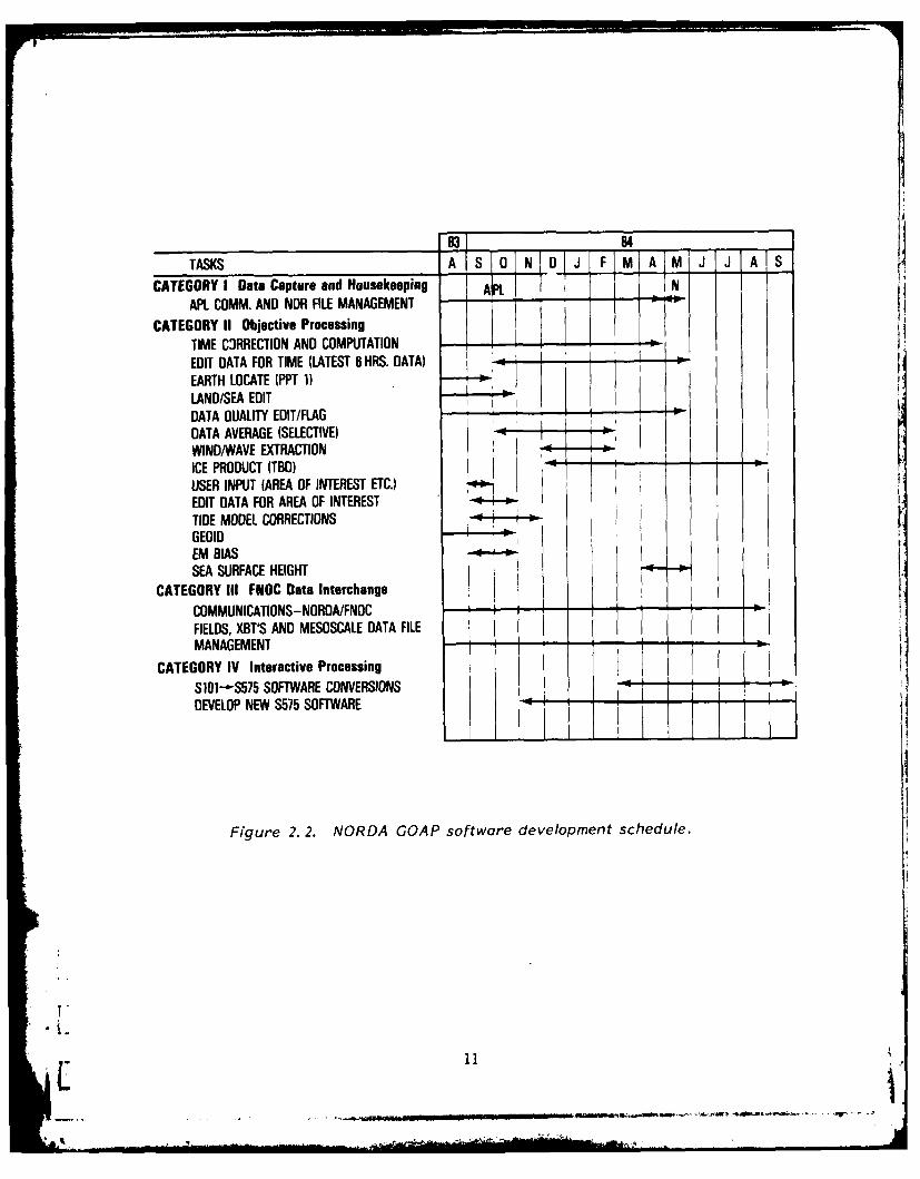
IThe major milestones in the GOAP data system development are listed in Figure
2.1 and described below. Figure 2.2 gives the schedule for development of elementsof the data system software. NORDA's on-site technical support contractor willimplement most of the NORDA software. NAVOCEANO has provided a LANDMASK program toproduce a land-sea boundary mask from the CIA World Data Bank 11. Another NAVOCEANO-provided program is GEORES, which contains an interpolation routine for use with thehigh-precision geoid. The NSWC program RPTIDE will be used in the calculation of thetidal correction [16]. Also, a procedure that was used by NSWC for SEASAT data willbe used to edit out bad data values [18]; NORDA will write new software that imple-ments this procedure. The NAVSPASUR program PPT1 will be used for ephemeris calcula-tions. The on-site contractor will also integrate the major software modules witheach other, with the operating system, and with the hardware. APL has provided linecontrol and file management software to NORDA, along with assistance in conversionand implementation. Plans for system testing and evaluation are being prepared byNORDA and its software contractor.
The schedule of activities must be coordinated with APL's schedule for devel-
opment of (their portion of) the GOAP software and data link. That schedule, whichappears in their Data Link Program Plan [1], calls for system (hardware and soft-ware) integration to be completed in March 1984. Some APL milestones that areclosely tied -) milestones for the NORDA site are also shown in Figure 2.1.
After launch of the satellite, approximately 30 days will be required for orbitstabilization, satellite system "health" verification, sensor data validation, etc.NORDA plans an additional 30-45 day test period after operational data transmissionfrom APL begins to provide a preliminary operational evaluation of the informationsystem.
2.2.3 SEASAT Simulation
The SEASAT Simulation project is complementary to the GOAP operational demon-stration. The program objectives are to develop and test methods and software foranalysis of GEOSAT altimetry and ancillary data by using existing data consisting ofconcurrent sets of:
(1) SEASAT/GEOS-3 altimetry;(2) NOAA-5/GOES IR SSTs;(3) SEASAT SMMR data;(4) In situ data (e. g., hydrography).
Despite considerable difference in the spatial resolution and sampling strategyof anticipated GEOSAT altimetry and GEOS-3/SEASAT altimetry, use of the existingdata should potentially set the stage for the GEOSAT demonstration. Many of thespecific details of the processing steps required to produce meaningful GEOSATmesoscale products will be defined by the simulation activities using existing dataor, in some cases, simulated data. Although not the primary objective of this work,it is anticipated that new insight and processing expertise also will be developedfor the DMSP SSM/I (based on the SEASAT-SMMR experience).
Progress to date, which has been somewhat slowed by slippage in the delivery
date for the NORDA SEL/1 2S system, consists of:
. Acquisition of satellite IR imagery, SEASAT SMMR, and SEASAT/GEOS-3 altimetryfor two initial simulation areas (NW Atlantic and Gulf of Mexico) is complete.
7'
9tC
4-4LL
+..U
I C
0N
3ON~ N)
*J.9J4U1 *~e~iuo~ ~ U
00
e~~~eI~ 14U1 lVN)U
+- +.L A.
4- 0
0 4-4
C O 0,4-4- 5 3a 0-
4- 0, 3 - -4-2 - 04- 1. 4-
o~' to 0'A.4- 4
a aA 0 0
8 ~10
TASKS A 0 JJ J AS
CATEGORY I Data Capture and HousekeepingAPL COMM. AND NDR FILE MANAGEMENT -- __"___
CATEGORY II Objective ProcessingTIME CRRECTION AND COMPUTATIONEDIT DATA FOR TIME (LATEST B HRS. DATA)--.EARTH LOCATE (PPT 1)LAND/SEA EDIT I
DATA DUALITY EDIT/FLAGDATA AVERAGE (SELECTIVE) -
WIND/WAVE EXTRACTIONICE PRODUCT (TBD)USER INPUT (AREA OF INTEREST ETC.)EDIT DATA FOR AREA OF INTERESTTIDE MODEL CORRECTIONSGEOIDEM BIASSEA SURFACE HEIGHT I-"
CATEGORY III FNOC Data Interchange I
COMMUNICATIONS-NORDA/FNOC --- -- -_
FIELDS, XBT'S AND MESOSCALE DATA FILEMANAGEMENT - -
CATEGORY IV Interactive ProcessingS101--$575 SOFTWARE CONVERSIONSDEVELOP NEW S575 SOFTWARE -:
Figure 2. 2. NORDA GOAP software development schedule.
I! .
* Cloud-free composites of IR images [8] for NW Atlantic area have been pro-duced for all possible time periods concurrent with SEASAT.
* Maps of residual (dynamic) topography have been produced in NW Atlantic areausing SEASAT/GEOS-3 altimetry and Marsh-Chang geoid.
* Synthetic Bathymetric Profiling System (SYNBAPS) bathymetry and geoid havebeen compared for aid in analyzing problems noted in the dynamic topography maps andwhich are the result of geodetic contamination of these residuals.
Anticipated progress through the end of second quarter of calendar year 1984consists of:
* Analysis of available in situ data in simulation regions using the MOODS database.
* Development of procedures for production of GEOSAT mesoscale product usingall existing data (along with simulations) in order to more specifically defineinterfaces addressed in the next version of this Test and Evaluation plan.
e Report on results of intercomparative analysis.
3. TEST AND EVALUATION
3.1 TEST PLAN
A data system test plan is being prepared by the software contractor concur-rently with system design for review and approval by NORDA. This plan will specifyprecisely what constitutes an acceptable test at each of the three testing levels:
(1) Stand-alone system testing;
(2) End-to-end interface testing;
(3) System performance testing.
The stand-alone system testing will verify that software and hardware have beensuccessfully integrated and that they function properly in a stand-alone manner. Theend-to-end interface testing will verify that data can be transferred between APL,NORDA, and FNOC as specified in the requirements. The system performance testingwill verify that the system will produce reasonable products given accurately simu-lated altimeter data. NORDA is conducting a simulation employing SEASAT and GEOS-3data, and NRL (with APL support) is responsible for preparing a standard test tapeof GEOSAT-like data. Also, the timeliness and machine resource constraints will beverified with realistic simulation data. NORDA will cooperate with FNOC by supplyingsimulated wind and wave data, when available, and consulting on throughout testingof FNOC operational marine wind and significant wave height analysis software.
The software contractor will prepare testing tools and plans, and then performthe testing. NORDA and its advisors will review the results. Testing should be com-plete by September 1984.
APL presented a plan for testing their portion of the GOAP information process-ing system in their Data Link Program Plan [1]. The only details shown there are for
12
-ira " : . - .,
IA
data link software verification and validation. Additional information on the APLtest plan was discussed with NORDA in March, 1984. Similar testing will be necessaryfor the FNOC portion of the system. That testing will primarily be the responsibil-ity of FNOC personnel, with NORDA providing technical support. An estimate of therequired FNOC effort for software (development, conversion, testing), hardware, andsecurity-related activities is given below:
FY-84: 0.3 man/years, $37.1K;
FY-85: 0.4 man/years, $38.3K;
FY-86: 0.3 man/years, $34.9K.
In addition, costs for telecommunications line setup and equipment rental byFNOC may reach $42K. The FNOC personnel involved to date or likely to be involvedinclude Jim Cornelius, Ron Gill, Sue Glassner, and John McKie. These estimated costsare not currently identified budget items. They are shown here only for completenessand to assist in planning.
The field verification portion of the testing will be coordinated with the 6.1GEOSAT program. To support the verification of GEOSAT-deduced dynamic topographies,several hydrographic and dynamic data types will be collected in the mesoscaledemonstration region. These data will consist of both AXBT flights (out of PaxRiver) and several shipboard CTD surveys. As well, advantage will be taken ofexisting current meter and inverted echo sounder/bottom pressure gauge arraysalready or soon to be implanted in the northwest Atlantic region. These existingarrays will be supplemented with additional sites. The data will be used to supportstudies aimed at the inference of subsurface thermal structure from the observeddynamic topographies.
3.2 Data System Operation and Evaluation
3.2.1 Procedures
After launch the evaluation of the system will consist of an initial verifica-tion that the requisite data products can be produced on the specified time line,with real data. This will be followed by a comprehensive months-long evaluation ofthe data products.
The preparation of the data products themselves will be a complex procedurethat involves the cooperative efforts of a number of people. Table 3.1 lists thesteps that will go into the production of the oceanographic data products. Figures3.1.a and b show timing estimates for various stages of the process of turning rawdata into products. It will be noted that some steps are keyed to data transmissionsfrom APL to NORDA (whose times depend on when the satellite is in view of thereceiving station), while other steps are more conveniently performed at certaintimes of day. Each day, an analyst at NORDA will evaluate the daily product beforetransmission to FNOC. Also, copies of the data will be studied by other Navy andcontractor analysts to assess the data in a more "off-line" mode. Every month, adata product quality evaluation meeting will be held at NORDA where the problems andprogress of the past month will be summarized and documented. This monthly product
quality report will be prepared by both the "on-line" analysts working at NORDA andthe "off-line" analysts working elsewhere.
13
!
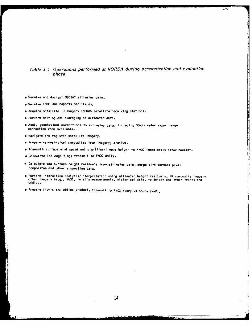
Table 3. 1 Operations performed at NORDA during demonstration and evaluationphase.
* Receive and docrypt GEOSAT altimeter data.
e Receive FNOC XBT reports and fields.
a Acquire satellite IR Imagery (NORDA satellite receiving station).
* Perform editing and averaging of altimeter data.
e Apply geophysical corrections to altimeter data, Including SSM/I water vapor rangecorrection when available.
* Navigate and register satellite Imagery.
e Prepare warmest-pixel composites from Imagery; archlve.
e Transmit, surface wind speed and significant wave heignt to FNOC Immediately after receipt.
* Calculate ice edge flag; transmit to FNOC daily.
0 Calculate sea surface height residuals from altimeter data; merge with warmest pixelcomposites and other supporting data.
" Perform Interactive analysis/interpretation using altimeter height residuals, IR composite Imagery,other Imagery (e.g., VAS), In situ measurements, historical data, to detect and track fronts andeddies.
" Prepare fronts and eddies product, transmit to FNOC every 24 hours (N-F).
14
L'
J TIMES (Min.)
* 75 Receive altimeter data from APL
60 Edit for blunder points and outliers*
40 Calculate average data record*
20 Preliminary calculations (e.g., earth-locate*iocean/land boundary, etc.)
10 Transmit wind/wave EDR to FNOC*
30-40 Calculate geophysical corrections
30-40 Calculate sea surface height residuals
30-40 Adjust winds and waves to grid
15-20 Adjust sea surface heights to grid
NOTES: 1) Timings are for 12 hours of altimeter observations.
2) Data processing for many of these operations is automatic (unattended);shown by *.
3) Time estimates Include data management steps.LFigure 3. 1. A. Operations keyed to altimeter data reception.
[15C
TIMES (Min.) ',ORK SHIFT
30-60 1,2 1 Check automatic processing results;modify if necessary
20 1,2 Prepare ice edge EDR 1
5 1,2 Receive and record FNOC fields
45 2 Produce gridded dynanic heights fromBT and climatology data
30 2 Navigate and register satellite inagery[
10-20 2 Prepare warmest-pixel composites i
120-180 1 Interactive analysis/interpretation
60 1 Prepare mesoscale feature product
20 1,2 Transmit results to FNOC
Figure 3. 1. B. Operations keyed to times of day.
16
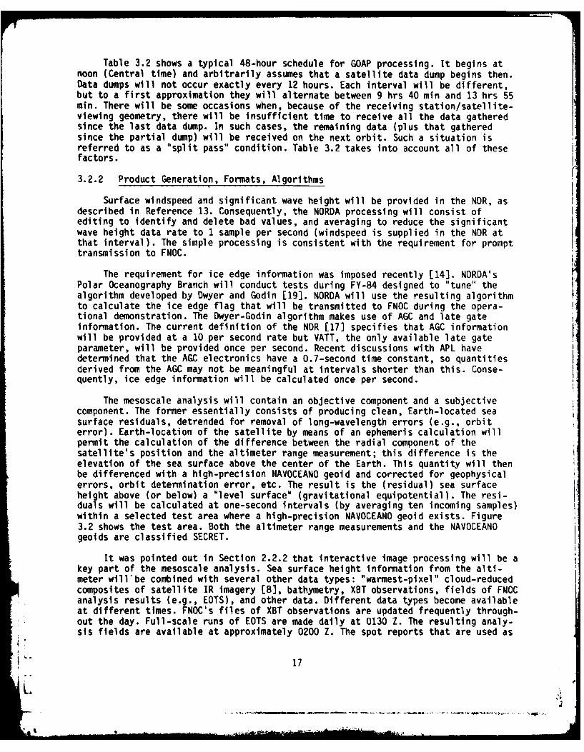
Table 3.2 shows a typical 48-hour schedule for GOAP processing. It begins atnoon (Central time) and arbitrarily assumes that a satellite data dump begins then.Data dumps will not occur exactly every 12 hours. Each interval will be different,but to a first approximation they will alternate between 9 hrs 40 min and 13 hrs 55min. There will be some occasions when, because of the receiving station/satellite-viewing geometry, there will be insufficient time to receive all the data gatheredsince the last data dump. In such cases, the remaining data (plus that gatheredsince the partial dump) will be received on the next orbit. Such a situation isreferred to as a "split pass" condition. Table 3.2 takes into account all of thesefactors.
3.2.2 Product Generation, Formats, Algorithms
Surface windspeed and significant wave height will be provided in the NDR, asdescribed in Reference 13. Consequently, the NORDA processing will consist ofediting to identify and delete bad values, and averaging to reduce the significantwave height data rate to 1 sample per second (windspeed is supplied in the NOR atthat interval). The simple processing is consistent with the requirement for prompttransmission to FNOC.
The requirement for ice edge information was imposed recently [14]. NORDA'sPolar Oceanography Branch will conduct tests during FY-84 designed to "tune" thealgorithm developed by Dwyer and Godin [19]. NORDA will use the resulting algorithmto calculate the ice edge flag that will be transmitted to FNOC during the opera-tional demonstration. The Dwyer-Godin algorithm makes use of AGC and late gateinformation. The current definition of the NOR [17] specifies that AGC informationwill be provided at a 10 per second rate but VATT, the only available late gateparameter, will be provided once per second. Recent discussions with APL havedetermined that the AGC electronics have a 0.7-second time constant, so quantitiesderived from the AGC may not be meaningful at intervals shorter than this. Conse-quently, ice edge information will be calculated once per second.
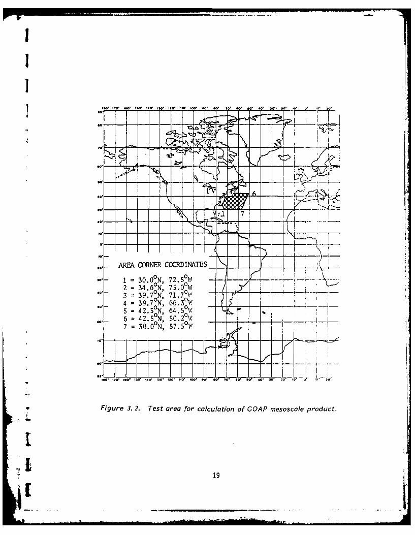
The mesoscale analysis will contain an objective component and a subjectivecomponent. The former essentially consists of producing clean, Earth-located seasurface residuals, detrended for removal of long-wavelength errors (e.g., orbiterror). Earth-location of the satellite by means of an ephemeris calculation willpermit the calculation of the difference between the radial component of thesatellite's position and the altimeter range measurement; this difference is theelevation of the sea surface above the center of the Earth. This quantity will thenbe differenced with a high-precision NAVOCEANO geoid and corrected for geophysicalerrors, orbit determination error, etc. The result is the (residual) sea surfaceheight above (or below) a "level surface" (gravitational equipotential). The resi-duals will be calculated at one-second intervals (by averaging ten incoming samples)within a selected test area where a high-precision NAVOCEANO geoid exists. Figure3.2 shows the test area. Both the altimeter range measurements and the NAVOCEANOgeolds are classified SECRET.
It was pointed out in Section 2.2.2 that interactive image processing will be akey part of the mesoscale analysis. Sea surface height information from the alti-meter will be combined with several other data types: "warmest-pixel" cloud-reducedcomposites of satellite IR imagery [8], bathymetry, XBT observations, fields of FNOCanalysis results (e.g., EOTS), and other data. Different data types become availableat different times. FNOC's files of XBT observations are updated frequently through-out the day. Full-scale runs of EOTS are made daily at 0130 Z. The resulting analy-sis fields are available at approximately 0200 Z. The spot reports that are used as
17
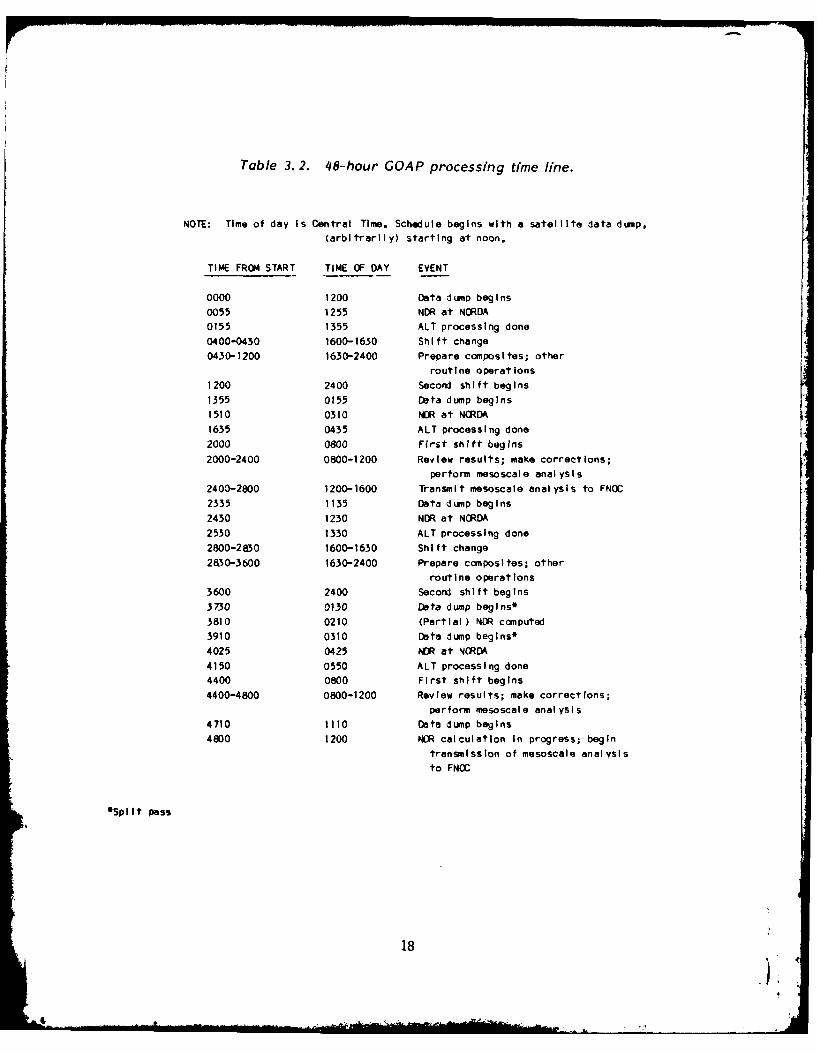
Table 3. 2. 48-hour GOAP processing time line.
NOTE: Time of day is Central Time. Schedule begins with a satellite data dump,(arbitrarily) starting at noon.
TIME FROM START TIME OF DAY EVENT
0000 1200 Data dump begins
0055 1255 NOR at NORDA0155 1355 ALT processing done
0400-0430 1600-1630 Shift change0430-1200 1630-2400 Prepare composites; other
routine operations
1200 2400 Second shift begins
1355 0155 Data dump begins1510 0310 NOR at NORDA
1635 0435 ALT processing done
2000 0800 First shift begins
2000-2400 0800-1200 Review results; make corrections;
perform mesoscale analysis2400-2800 1200-1600 Transmit mesoscale analysis to FNOC2335 1135 Data dump begins
2430 1230 NOR at NORDA2530 1330 ALT processing done
2800-2830 1600-1630 Shift change2830-3600 1630-2400 Prepare composites; other
routine operations3600 2400 Second shift begins
3730 0130 Data dump begins*3810 0210 (Partial ) NOR computed3910 0310 Data dump begins*
4025 0425 NDR at NORDA4150 0550 ALT processing done4400 0800 First shift begins
4400-4800 0800-1200 Review results; make correct Ions;perform mesoscale analysis
4710 1110 Data dump begins
4800 1200 NOR calculation In progress; begintransmission of mesoscale analysis
to FNOC
*Split pass
18
IL
II
So.
SAREA CORNER COORDINATES__
4 =39.70N, 66:30W
eO7s6IO 00 1 01 10S? 0 54 0 0
5 2SN 6.5I0 19
6 2 N 5.2I
input to EOTS come in throughout the day; those reports are also available. Someother FNOC analysis fields that may be used are: A29$ and A30$, u and v componentsof marine winds, run at six-hour intervals starting at 0420 Z; AO1$, surface pres-sure, run at same times as A29$ and A30$ (12-hour prognostic fields are available atany time); A1O, surface air temperature, run at 0500 Z and 1700 Z; and A12$, surfacewater vapor pressure, run at 0500 Z and 1700 Z. The feasibility of obtaining precip-itable water data from NIMBUS-7 SMMR and NOAA series TOVS to use in calculating thetropospheric water vapor path length correction is being investigated. A subjectivedetermination of the mesoscale feature content will be made by interpretation of theabove data, comparison with other days' results, etc.
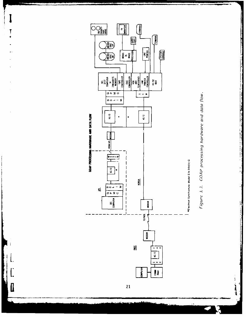
The raw altimeter height words and the geoids will be classified SECRET.Consequently, the telecommunications line between NORDA and APL, and NORDA's GOAPcomputing facility, must be operated in a classified mode. It is assumed at thistime that the mesoscale product will be classified. Many of the XBT reports to beobtained from FNOC are classified. So it is also planned for the communications linkbetween NORDA and FNOC to be classified. Figure 3.3 shows a block diagram of theAPL-NORDA-FNOC information processing hardware, including the communications links.
The windspeed, wave height, and ice data will be transmitted to FNOC in theform of a SEAFORM [4] environmental data record (EDR). Some format modificationswill be necessary. As described in Reference 4, SEASAT altimeter geophysical datarecords (GDRs), for which SEAFORM was written, only contained wave height informa-tion. A review to determine the needed changes is in progress.
FNOC [6] stated a requirement "that ocean feature information be sent in adigital form suitable for direct assimilation into the Expanded Ocean ThermalStructure (EOTS) analyses." The existing EOTS bogus capability requires sea surfacetemperatures (SSTs) or temperature gradients. The GEOSAT altimeter will provideinformation on sea surface topography; in cloud-covered regions where there are nosurface observations, no other information may be available. Consequently, it willbe necessary to infer thermal gradients from the surface elevation measurementsprovided by the altimeter. This is a 6.1 or 6.2 problem, and this aspect of theGEOSAT data assimilation must be regarded as a weak link in the system; an opera-tional capability will not be ready until the FY-86/87 time frame. Other workdirected toward the objective assimilation of altimeter-derived sea-surface heightswas described in Section 2.2.2.
The entire question of assimilation at FNOC of information provided by GEOSATis critical to the success of GOAP. GEOSAT will potentially provide significantincreases in certain types of information, which, in turn, might lead to somechanges in procedures. Actual experience with the data is the only practical way toevaluate the utility of GEOSAT; proper design of the tests is important. A multi-stage plan for the assimilation of the data from GEOSAT (and later satellite alti-meters) is envisioned, of which the first two stages can be defined now.
Briefly, those two stages are:
(1) Assimilation into, or other use with, existing FNOC models.
(2) (First round of) possible modification of existing analysis methods orimplementation of new ones.
20
-i.
iI00.~
w w
FgI
L* U
• I 21
I -m
I-l I~ •I J~b
For the first stage, the most likely use of wind data is as input to the MarineWind analysis [3]. NORDA understands that some capability to ingest significant waveheight data exists; additionally, a historical comparison with SOWM data would beuseful. A potential use of the ice product is to produce a plot of the ice edge. Itis believed that existing FNOC software could be used or adapted. As discussedabove, the mesoscale feature information is intended to be used as input to EOTS orOTIS, but the capability for such usage will not be ready in the initial part of theoperational demonstration.
The ideas for stage 1 are based on discussions between NORDA and representa-tives of other organizations, primarily Jim Cornelius, Mike Clancy, and Leo Clarkeof FNOC, Tom Kleespies of NEPRF, and Sheldon Lazanoff of Science Applications, Inc.NORDA intends to pursue the development of the assimilation methods to derivemaximum benefi; from the GOAP data. NORDA also intends %o work with FNOC and NEPRFto study some reservations that have been expressed concerning the assimilation ofsurface scalar winds from GEOSAT into the Navy Operational Global AtmosphericPrediction System. Briefly, these reservations include the following points: GEOSATdata dumps occur about twice a day, not necessarily near NOGAPS update times. So,very little wind data transmitted to FNOC may be sufficiently "fresh" to be withinthe cutoff window for the analysis. Because of this and the nature of the groundtrack, the net effect might be the assimilation of data with wave number 14. Also, asurface wind analysis is not performed by NOGAPS (although NORDA understands thatNEPRF is planning for a NOGAPS upgrade that includes use of winds), and surfacewinds are not used to initialize the forecast model. NOGAPS diagnostically computesthe ocean surface winds from the free atmospheric prognostic equations, and requiresa vector wind field rather than scalar winds.
Considerations such as these will influence future developments in the assimi-lation of altimeter data. For the first set of modifications or enhancements toexisting analysis methods, NORDA is evaliating and will probably support some of theproposed efforts listed below, from Refererce 7. The numbers identifying tasks inthe following list do not necessarily correspond to the task numbers in Reference 7:
(1) Develop an algorithm to compute wind wave and swell heights from signifi-cant wave heights and wind speeds measured by the GEOSAT altimeter.
(2) Compare FNOC Global Spectral Ocean Wave Model (GSOWM) SWHs with SWHs fromthe GEOSAT altimeter and buoys. Conduct a detailed error analysis of the GSOWM out-put so that when the task is completed, the analysis indicates th2 direction to betaken for improving the operational computer models.
(3) Develop algorithms to compute GEOSAT one-dimensional (energy vs. frequency)wave spectra using GEOSAT windspeed and SWHs and FNOC meteorological analyses.
(4) Compare wave spectra derived from altimeter data to SOWM and NDBO wavespectra.
(5) Evaluate the GEOSAT altimeter backscatter data as a possible source ofambient noise information for use in acoustic prediction models.
Table 3.3 is a chart that contains estimates of the usage of NORDA informationprocessing system resources for each major function during normal operations. Itemsincluded are "wall clock" time (cpu time will be less), disc storage, tele-
communication lines, 12S image processing station usage, tape storage, and line
22
printer and hard copy device utilization. Numbers in the table indicate the averageeffect of one day's operations. Normally, several days' accumulation of workingfiles will be retained on the disc, with backups to tape for archival purposes madeperiodically.
One potentially important geophysical error source is the range error inducedby tropospheric water vapor. The SEASAT SMMR was able to provide a reasonably goodcorrection. An alternative correction that was used for SEASAT, based on FNOCfields, did not have sufficient spatial resolution to be of use in the mesoscalerange. GEOSAT will not carry any remote sensors other than the altimeter, and thereprobably will not be any SMMRs in operation during the GEOSAT mission. The DMSPSSM/I, which is scheduled to be launched several months after GEOSAT, is a similarinstrument. NORDA is working with NRL in the development of an algorithm to calcu-late the tropospheric water vapor range correction from SSM/I measurements. Whenthis is operational, water vapor corrections will be utilized in GOAP, as shown inTable 3.1. A separate NORDA Remote Sensing Branch project to develop a procedure forusing NOAA AVHRR data to derive an interim water vapor correction is proceeding andshowing some successful results.
3.3 SYSTEM INTEGRATION AND TESTING
3.3.1 System Description
The portions of the overall GOAP system of primary interest to NORDA are com-munications link (APL-NORDA and NORDA-FNOC) hardware and software, and NORDAprocessing hardware and software. The communications link hardware consists ofcomputer interface units, encryptors/decryptors, modems, and communications lines.The encryptors/decryptors are GFE and will be obtained by NAVELEX and CNOC. Theinterface units, communications lines, and modems will be provided by the GOAP proj-ect and CNOC. APL will write the communications software for the APL-NORDA link. TheNORDA processing hardware is described in Table 2.1, and Figure 3.4 shows the floorplan for equipment layout. The processing hardware is being procured separately,funded in part by OP-952 FY-82 funds. The NORDA GOAP processing software will bedeveloped as discussed in Section 2.2.2, and supported by GOAP (SOTA) funds.
NAVELEX is providing the APL-NORDA telecommunications link. A TSR was forwardedto NAVTELCOM in December 1983, for the DDS-quality line, modems, and hookup.Arrangements for the NORDA-FNOC line are being handled by CNOC.
3.3.2 Personnel
During the planning and implementation phases, tasks are being performed byNORDA analysts and contractor personnel with NORDA coordination. APL is providingtechnical support for the conversion of the line control software to NORDA's com-puter, for the procurement and installation of the 9.6 kb/s line and modems at APLand NORDA, and for the installation of the data line encryptor, decryptor, andCrypto Ancillary Unit (CAU) if needed. NORDA and its software contractor are respon-sible for the design of the software system functional and detailed requirements.The software contractor is responsible for the design and implementation of thecomputer software modules, for preparation of the system test plan, and for systemtesting. NORDA is also being assisted by several outside consultant/advisors, chosenfor their unique capabilities and talents. Among these are NAVOCEANO personnel.
I23
LL. LU LU CA
.0 d to
th z
0- 0§ U - 8 0
tt U. -11 :"
0 0 N: 00 C>O 0 00:
LU
LU ~ ~ ~ C a 0 00 0 0
QU)0 0 0 0 00 0-0 0 0 0 0 0
4.1~ 0 1
a 0 0 0
0N -- , a0 M W
LL- 74 N
L) ~ 0 tN0N
C,
LUa i WPC - .. 0 0 - -
0
4c LA) 84 !Z j - %
n -j
c'- CA- C
L- L
&I .I Li i) N
Cj~CD
I- I:
___~~ ~ __ _ _ __ 0cu
LL..
C)C
.0 .I
0~ 00l
8 L
I 00
0. -
DRFING TBEMNAS
PRO F~F1(GFL 30J40) SECRET GEOSATJECTOR H... LH ANALYST ROOM
LAYOUT TABLE=
CHh
0
LIGHTCH__TABLE LYU
TABLE C(MIM-4) WCH-
CH SECRET GEOSATPROCESSING AREA
TrAPE STORAGE
ARCHIVE AREA
Cm Cz CD CD cm Cm L CI3-ICW
U.. _ "MAP FLATS I
Figure 3. 4. Floor plan for NORDA GOAP processing facility.
26
I4
During the demonstration/evaluation and operation phases, the system will beoperated by NORDA analysts and (a minimum of) two contractor personnel. The formerwill conduct the oceanographic analyses--primarily, detection and monitoring ofmesoscale features--while the latter will perform the support tasks listed inFigures 3.1 a and b. Normal operation will consist of two shifts, five days a week.The contractor personnel will work the second shift.
During this period the evaluation of the system will consist of an initialverification that the requisite data products can be produced on the specified timeline, with real data. This will be followed by a comprehensive evaluation of thequality and utility of the data products. FNOC, NAVOCEANO, and others will cooperatewith NORDA in the evaluation.
The quality of the data products will be evaluated by qualified oceanographicanalysts working at NORDA and elsewhere. Each day analysts will determine that theproducts are in reasonable accord with data from satellite IR sensors, with XBTdata, with previous GEOSAT data, and with current mesoscale-resolving circulationmodels. To facilitate this evaluation the GOAP information processing system willhave access to all the above-mentioned data types plus wide variety of graphics andmanipulative capabilities to recall, display, and merge current and historical data.
The utility of the data products will be evaluated primarily by analysts atFNOC and the regional centers. Analysts at these locations will determine to whatextent these GOAP data products can be used to generate improved FNOC "now casts"and forecasts in an operational environment. Likewise, the regional centers willdetermine to what extent these data products are useful in preparing their own morespecialized data products. Basically, the analysts at FNOC and at the regionalcenters will determine whether or not their deliverables are improved through theuse of GOAP data products. In some cases the GOAP data products may be directlyuseful to Navy line elements such as the P3 squadrons. In this case these userswould be contacted for their response to the GOAP data products. The FNOC andregional center analysts will prepare a bimonthly report on GOAP data utility.
3.3.3 Orientation Plan
Orientation and training will be performed by three methods:
(1) On-the-job experience with the system acquired during pre-test developmentand operation of the system.
(2) Formal instruction on the system by the principal investigator or theinformation processing system contractors(s).
(3) Detailed written instruction in the form of a user's manual.
3.3.4 Testing
The different elements of the test procedures have been discussed in previoussections. It should be noted that the development of a detailed test plan is an im-portant part of the information processing system development. Plans for systemtesting and evaluation are being developed concurrently with the system design.Prior to launch, simulated GEOSAT data can be used in the testing. NRL/APL hasprepared a simulated data tape using synthetic data. In the near future, NRL/APLplans to prepare a new tape containing data obtained in simulator tests of theGEOSAT altimeter.
27

3.3.5 Transition to FNOC or NAVOCEANO
NORDA is committed to a 12-18 month operational evaluation with analysis to beperformed at NORDA and results transmitted to FNOC. Subsequently, in accordance withoriginal guidelines and References 20 and 21, the responsibility for processing andanalysis will be transferred. The schedule for the transition will be keyed to theschedule for the FNOC Satellite Processing Center (SPC) upgrade, if FNOC is selectedto continue the GOAP processing. NORDA, APL, and its contractors will provide tech-nical support for the transition, and will strive to prevent any interruption of theanalysis during that time. It is planned that the decision when to transfer thisfunction will be made after the value of GEOSAT data is determined and communicatedto all parties concerned.
3.3.6 Extended Exact Repeat Mission
The primary GEOSAT mission is the collection of global sea surface topographyat a cross-track spacing of approximately 5 km. These global data will be averagedto compute a mean sea surface topography in order to approximate the long-wavelengthcomponents of the marine geoid. This primary mission is sponsored by OP-211. The(secondary) oceanographic mission (GOAP), outlined above, is sponsored by OP-952.
The nominal geodetic mission will be completed in approximately 18-20 months.Subsequently, GEOSAT may be maneuvered into a slightly different orbit whose groundtrack "laydown" would have characteristics more favorable for sampling the oceanicmesoscale field, and could provide useful information even in areas where no precisegeoid exists. This proposed extended, exact repeat mission (ERM) is discussed byMitchell [15]. NORDA would be involved in the processing for the ERM.
Should such an extended, exact repeat mission be realized it is likely that themesoscale product would be expanded to global coverage. The processing andinterpretation of the data may be somewhat simplified given the exact repeat natureof the ground tracks during the proposed extended mission, though the volume of datato be handled will clearly be increased. More specific estimates of the impact of anextended GEOSAT-A mission on the GOAP will be forthcoming in the next revision ofthis Test and Evaluation Plan.
REFERENCES
[11 GEOSAT-A Ocean Applications Program APL/NORDA Data Link Program Plan. JHU/APLDocument SDO-6352.1, July 1982; JHU/APL Document SDO-6352.2, January 1983.
[2] GEOSAT-A Information Processing System (GIPS) Conceptual Design. JPL Document,16 December 1982.
[3] U.S. Naval Weather Service Numerical Environmental Products Manual. NAVAIR50-1G-522, 1 June 1975.
[4] Modified SEAFORM Maintentance Program Manual. Systems and Applied SciencesDocument SSD-T-6088-0092-82, 2 December 1981.
[51 Eppler, Duane T. (1982). Possible Applications of GEOSAT-A Radar Altimeter Datato Ice Forecasting in Polar Regions. NORDA Technical Note 177, November.
[6] FLENUMOCEAN CEN ltr 3900 ser 1300 of 10 November 1982.
28
I
I [7] Applications of GEOSAT Altimeter Data. SAI Proposal 1-425-71-830-34, 16 December.1982.
I 8] Lybanon, M., and J. D. McKendrick (1983). Some Applications of Image Processingin Oceanography. Proceedings, The Fifteenth Southeastern Symposium on System Theory,pp. 138-142, IEEE Catalog No. 83CH1866-3, 28-29 March.
I (9] FNOC Computer User Guide. Revision 13, 10 May 1983.
£10] NAVPOLAROCEANCEN Itr 3160 ser 371 of 11 June 1983.
[11] FLENUMOCEANCEN Itr 3900 ser 750 of 11 July 1983
I [12] FLENUMOCEANCEN Itr 13000 ser 759 of 13 July 1983.
[131 Grunberger, P.J. (1984). GEOSAT-A Ocean Applications Program Data Link/NORDAInterface Control Document. JHU/APL 7292-9810, February 1984.
[14] CNO (OP-952) ltr ser 952D/3U349864 of 20 July 1983.
£15] Mitchell, Jim L. (1983). A Position Paper: Mesoscale Oceanography from GEOSAT.NORDA Technical Note 226, August.
[16] Schwiderski, E.W., and L.T. Szeto (1981). The NSWC Global Ocean Tide Data Tape(GOTD), Its Features and Application, Random-Point Tide Program. NSWC TR 81-254,June 1981.
[17] Cole, T.D. (1983). GEOSAT-A Data Users/Ground System Interface Control Document(ICD). JHU/APL 7292-9510, August 1983.
[18] Futcher, J.M. (1980). Program Maintenance Manual for SEASAT REDUCE Program.* NSWC TN 80-96, April 1980.
- £19] Dwyer, R.E., and R.H. Godln (1980). Determining Sea-Ice Boundaries and Ice* Roughness Using GEOS-3 Altimeter Data. NASA Contractor Report 156862.
£20) COMNAVOCEANCOM Itr N5:ej Ser 5326 of 12 October 1983.
[21] COMNAVOCEANCOM ltr N5:pr Ser 5020 of 14 February 1984.
I
1
...... ..... ..............................- .
II itji ASS: IFrl.,
SECURITY CLASSIFICATION OF THIS PAGE (Wft Do. Entered)
READ INSTRUCTIONSREPORT DOCUMENTATION PAGE BEFORE COMPLETING FORM1. REPORT NUMBER 2. GOVT ACCESSION NO. 3. RECIPIENT'S CATALOG NUMBERORDA Technical Note 270 b -A / / d.3
i4. TITLE (and Subtitle) 5. TYPE OF REPORT & PERIOD COVERED
GEOSAT Ocean Applications Program (GOAP) FinalInitial Data Processing and Analysis System S. PERFORMING ORO. REPORT NUMBER
Test and Evaluation Plan7. AUTHOR(a) . CONTRACT OR GRANT NUMBER(&)
Matthew Lybanon
9. PERFORMING ORGANIZATION NAME AND ADDRESS 10. PROGRAM ELEMENT, PROJECT. TASKNaval Ocean Research and Development Activity AREA & WORK UNIT NUMBERS
Ocean Science Directorate P.E. 63704NNSTL, Mississippi 39529
It. CONTROLLING OFFICE NAME AND ADDRESS 12. REPORT DATE
April 1984Same 13. NUMBER OF PAGES 291t4. MONITORING AGENCY NAME & ADDRESS(II different from Controllind Office) 15. SECURITY CLASS. (of thie report)
Unclassified15. OECLASSIFICATION DOWNGRADING
SCHEDULE
16. DISTRIBUTION STATEMENT (of this Report)
1Approved for public release. Distribution unlimited
17. DISTRIBUTION STATEMENT (of the abetrect entered In Block 20, It different frm Report)
IS. SUPPLEMENTARY NOTES
1IS. KEY WORDS (Continue on reverse side if nocesaary nd identify by bfock fnamber)
GEOSAT microwave altimetry1 Test and evaluation information processing systems
20. ABSTRACT (Continue on reverse aide if necessary and Identify by block namber)NORDA's Remote Sensing Branch will conduct an operational demonstration aspart of the GEOSAT Ocean Applications Program (GOAP). The purpose of thedemonstration is to evaluate the extent to which oceanographic products can bederived from altimeter data In near real-time. This technical note describes theinformation processing system that will be used for this task, and plans for itsdevelopment and testing. It also covers plans for the operation of the system,personnel assignments and training, evaluation of the products, and eventual
Ii transfer of the operations to FNOC gr NAVOCEANO.
DO o 1473 EDITIONo , Iov tos osoLsr$IN 0 102N LF O14 6601 CLAWSSIFIEIS/N 012- LF-014- 601 $1[UllITY CL.ASIFICAION OF THISl PAGE[ (Men eto tJ