Embed Size (px)
Citation preview
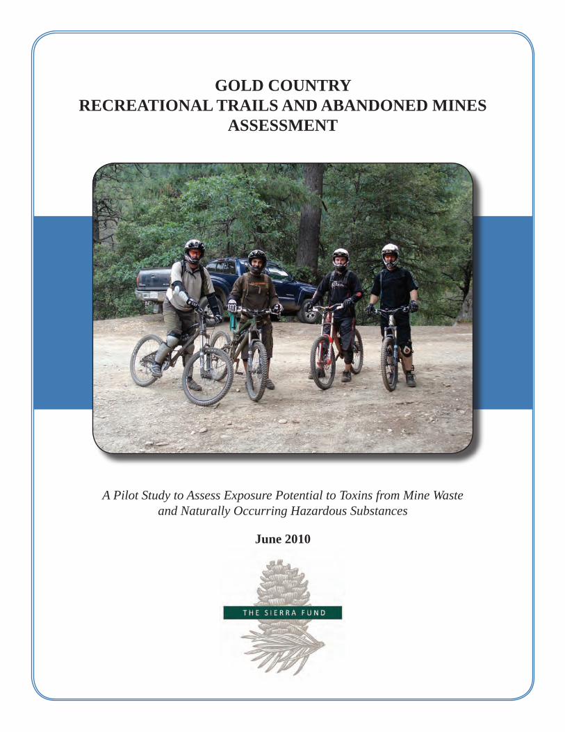
GOLD COUNTRYRECREATIONAL TRAILS AND ABANDONED MINES
ASSESSMENT
A Pilot Study to Assess Exposure Potential to Toxins from Mine Waste and Naturally Occurring Hazardous Substances
June 2010
ABOUT THE SIERRA FUND
The Sierra Fund is the only nonprofit community foundation dedicated to the Sierra Nevada. Our mission is to increase and organize public and private investment to protect and restore the region’s natural resources and communities. We pursue this mission three ways: through Advocacy to bring public funding to the region, Philanthropy to provide a vehicle for private funding, and Strategic Campaigns that pursue critically needed programs in the Sierra. Since 2006, the Mining’s Toxic Legacy Initiative has been our primary strategic campaign. The goal of this Initiative is to assess and address the ongoing impacts of toxins left over from the Gold Rush and subsequent mining in the Sierra Nevada. In 2009, The Sierra Fund initiated two pilot studies to learn whether people who live, work, or recreate in the Sierra Nevada are being exposed to legacy mining toxins including mercury, arsenic, lead, asbestos and chromium. Results of the study of Gold Country Recreational Trails and Abandoned Mines Assessment are presented here. The 2009 Gold Country Angler Mercury Exposure Survey, which looks at exposure to mercury from eating fish caught in Sierra lakes and rivers, will be released in July 2010. Copies of these documents as well as more information about our work may be obtained online at www.sierrafund.org or by contacting The Sierra Fund directly.
The Sierra Fund
432 Broad Street - Nevada City, CA 95959 (530) 265-8454 - [email protected]
www.sierrafund.org
The Sierra Fund Recreational Trails and Abandoned Mines Assessment Page 2
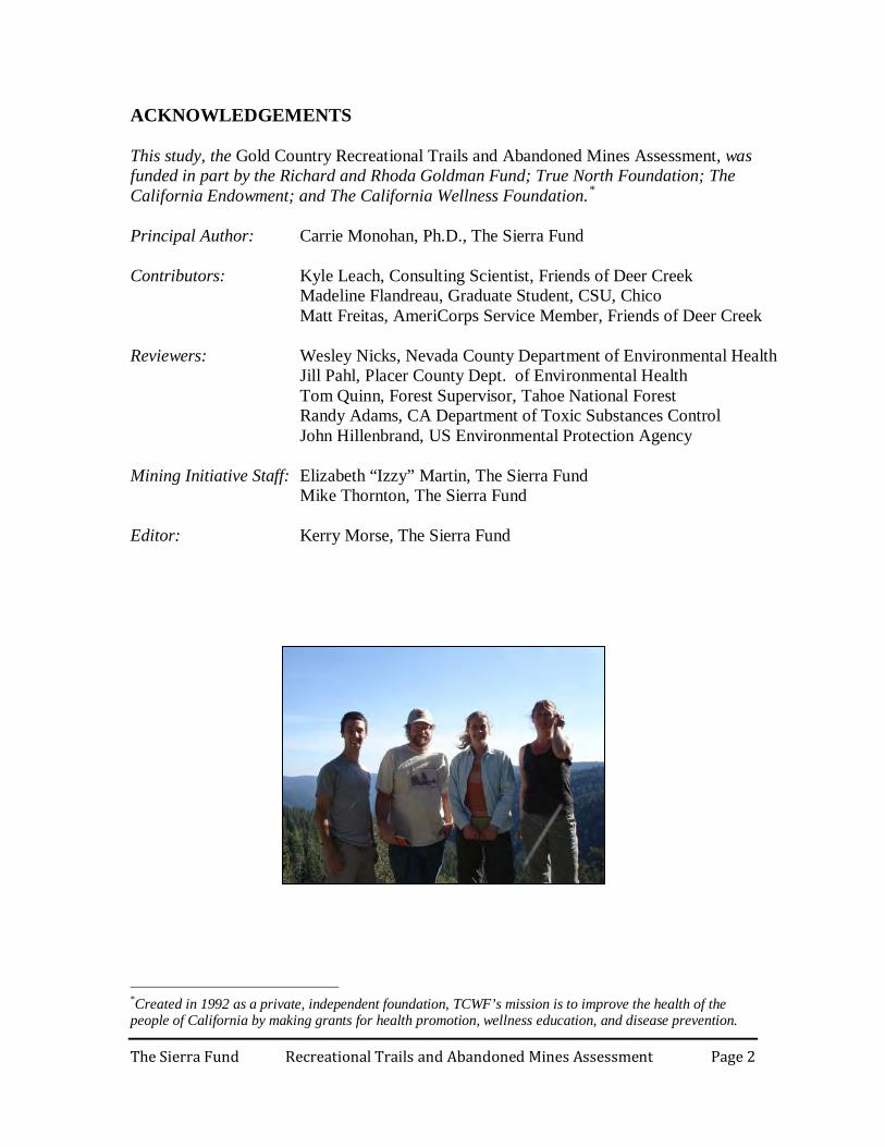
ACKNOWLEDGEMENTS This study, the Gold Country Recreational Trails and Abandoned Mines Assessment, was funded in part by the Richard and Rhoda Goldman Fund; True North Foundation; The California Endowment; and The California Wellness Foundation.*
Principal Author: Carrie Monohan, Ph.D., The Sierra Fund Contributors: Kyle Leach, Consulting Scientist, Friends of Deer Creek Madeline Flandreau, Graduate Student, CSU, Chico Matt Freitas, AmeriCorps Service Member, Friends of Deer Creek Reviewers: Wesley Nicks, Nevada County Department of Environmental Health Jill Pahl, Placer County Dept. of Environmental Health Tom Quinn, Forest Supervisor, Tahoe National Forest Randy Adams, CA Department of Toxic Substances Control John Hillenbrand, US Environmental Protection Agency Mining Initiative Staff: Elizabeth “Izzy” Martin, The Sierra Fund Mike Thornton, The Sierra Fund Editor: Kerry Morse, The Sierra Fund
*Created in 1992 as a private, independent foundation, TCWF’s mission is to improve the health of the people of California by making grants for health promotion, wellness education, and disease prevention.

The Sierra Fund Recreational Trails and Abandoned Mines Assessment Page 3
TABLE OF CONTENTS
ABOUT THE SIERRA FUND ............................................................................................................... 1
ACKNOWLEDGEMENTS .................................................................................................................... 2
TABLE OF CONTENTS ........................................................................................................................ 3
ABSTRACT ............................................................................................................................................ 4
INTRODUCTION .................................................................................................................................. 5
Abandoned Mines in California ............................................................................................................ 5
Chemical Hazards of AML Sites .......................................................................................................... 6
PURPOSE AND SCOPE ........................................................................................................................ 9
METHODOLOGY ............................................................................................................................... 10
Site Selection ..................................................................................................................................... 10
Field Methods .................................................................................................................................... 11
Soil Sampling .................................................................................................................................... 12
Laboratory Sample Analysis............................................................................................................... 12
Selection of Laboratory ...................................................................................................................... 13
Evaluation of Sample Results and Constituents of Concern ................................................................. 14
SAMPLE RESULTS AND DISCUSSION ........................................................................................... 17
Downieville Area ............................................................................................................................... 17
Nevada City Area............................................................................................................................... 23
Foresthill Area ................................................................................................................................... 25
SUMMARY AND RECOMENDATIONS ........................................................................................... 27
Summary of Results ........................................................................................................................... 27
Recommendations .............................................................................................................................. 28
Posted Warnings................................................................................................................................... 28
Additional Sampling..............................................................................................................................289
Dust Exposure Study............................................................................................................................. 30
Survey of Recreationists........................................................................................................................ 31
REFERENCES ..................................................................................................................................... 32
TABLES AND FIGURES............................................................................................................................ 33
APPENDICES
ALS-Chemex Quality Assurance Overview…………….……………………………............. Appendix A
ALS-Chemex Geochemical Procedure ME-ICP 41 ……………………………………..........Appendix B
Chain of Custody and Laboratory Reports ……………………………………………............Appendix C
Correlations and Summary Statistics between ALS and EPA Data…………………….......... Appendix D Peer Review Process...................................................................................................................Appendix E
The Sierra Fund Recreational Trails and Abandoned Mines Assessment Page 4
Gold Country Recreational Trails and Abandoned Mines Assessment A pilot study to assess potential exposure to toxins from mine waste and naturally occurring hazardous substances by recreationists including off-highway vehicle (OHV) riders, mountain bikers, horseback riders, runners and hikers ABSTRACT The physical dangers to recreationists at abandoned mine sites are well known, but the hazards associated with exposure to heavy metals in dust at abandon mine sites are not well understood. This pilot study identified contaminants of concern (COC) at popular recreation areas around Downieville, Nevada City, and Foresthill, CA. Methods: COCs were defined by the concentration of heavy metals in surface soils samples at levels exceeding secondary screening levels. Secondary screening levels were established in accordance with commonly used environmental exposure thresholds set by State and Federal Agencies. The secondary screening level for arsenic was selected as 270 mg/kg in accordance with the California Department of Toxic Substances Control (DTSC) Empire Mine assessment for a recreational runner. The secondary screening level for lead was selected as 1,000 mg/kg according to the Bureau of Land Management (BLM) camper or ATV driver criteria. The screening levels used in this study were meant to be used in the site assessment process to help identify areas that require further evaluation, and were not meant to be used as cleanup goals or regulatory standards without consideration of site-specific factors and exposure scenarios. Results: In the Downieville area, Saddleback Road had elevated levels of lead (max. 1,570 mg/kg), the Columbo Mine area had elevated levels of arsenic (max. 442 mg/kg), and Slug Canyon on the North Yuba Trail Extension also had elevated levels of arsenic (max. 439 mg/kg). In the Nevada City area, Banner Mountain Trail and mine waste above Little Deer Creek had elevated levels of arsenic (max. 4,050 mg/kg). In the Foresthill off-highway vehicle (OHV) designated recreation area, lead was at elevated levels in the Marall Chrome Mine (max. 4,790 mg/kg). In addition to heavy metal contamination, numerous abandoned mine land sites in recreation areas also had asbestos. Asbestos was detected along Saddleback Road adjacent to serpentine rock outcrops, in the Goodyears Bar assessment area, along the Newtown Ditch Trail and in the Foresthill OHV Area including the Marall Chrome Mine pit and on the Loop 4 Trail (max. 40% chrysotile). Recommended Actions:
1. Post warnings in areas with known contamination, 2. Further assess areas where elevated levels of contaminants were found, 3. Conduct a dust exposure study to determine exposure scenarios of different
recreational activities, and 4. Conduct a user survey to inform education of populations at risk of being exposed
to contaminated dust during recreational activities in the Gold Country.
The Sierra Fund Recreational Trails and Abandoned Mines Assessment Page 5
INTRODUCTION A trail assessment was conducted in the Sierra Nevada to provide preliminary information on the potential for human exposure to mining toxins from recreational activities such as off-highway vehicle (OHV) riding, mountain biking, horseback riding, running and hiking. The field investigation was performed during the summer of 2009. Surface soil samples were taken in recreation areas impacted by mine waste or naturally occurring hazardous substances and evaluated to identify contaminants of concern and potentially high risk recreation areas. Based on the soil sample results recommendations were developed to further characterize health risk factors to recreationists at specific locations.
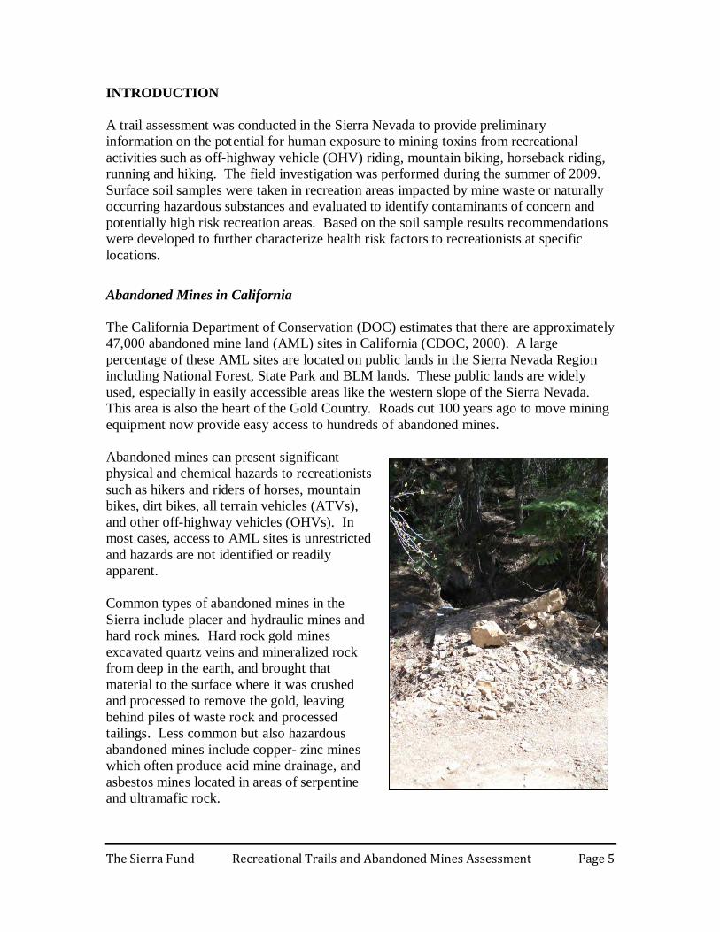
Abandoned Mines in California The California Department of Conservation (DOC) estimates that there are approximately 47,000 abandoned mine land (AML) sites in California (CDOC, 2000). A large percentage of these AML sites are located on public lands in the Sierra Nevada Region including National Forest, State Park and BLM lands. These public lands are widely used, especially in easily accessible areas like the western slope of the Sierra Nevada. This area is also the heart of the Gold Country. Roads cut 100 years ago to move mining equipment now provide easy access to hundreds of abandoned mines. Abandoned mines can present significant physical and chemical hazards to recreationists such as hikers and riders of horses, mountain bikes, dirt bikes, all terrain vehicles (ATVs), and other off-highway vehicles (OHVs). In most cases, access to AML sites is unrestricted and hazards are not identified or readily apparent. Common types of abandoned mines in the Sierra include placer and hydraulic mines and hard rock mines. Hard rock gold mines excavated quartz veins and mineralized rock from deep in the earth, and brought that material to the surface where it was crushed and processed to remove the gold, leaving behind piles of waste rock and processed tailings. Less common but also hazardous abandoned mines include copper- zinc mines which often produce acid mine drainage, and asbestos mines located in areas of serpentine and ultramafic rock.

The Sierra Fund Recreational Trails and Abandoned Mines Assessment Page 6
Physical Hazards of AML Sites Physical hazards at abandoned mine land (AML) sites include unmarked or concealed shafts or tunnels that result in serious injury and death to recreationists in California on an annual basis. The national Mine Safety and Health Administration’s “Stay out Stay Alive” program promotes public awareness of mine hazards and includes efforts to close hazardous mine shafts and tunnels. Physical hazards are comparatively easy and inexpensive to close, so any AML assessment efforts should include identification of significant physical hazards and reporting to the proper authorities.
Chemical Hazards of AML Sites Chemical hazards at abandoned mine land sites include heavy metals that are hazardous to human health, such as lead and arsenic, but may also include other hazardous materials such as abandoned fuel tanks and asbestos. The effects of chemical hazards are perhaps less immediate than those of physical hazards, but potentially just as serious. Contaminants at AML sites occur in different ways:
1) Mine waste can have elevated concentrations of naturally occurring toxic metals such as arsenic and lead which were disturbed and distributed by the mining process and released into the environment.
2) Naturally mineralized soil in areas surrounding gold deposits can contain arsenic at concentrations considered hazardous to human health. Mineralized soil often does not appear different from other soil and can only be identified by laboratory testing.
3) Imported chemicals that were used to recover gold can remain in the environment,
specifically mercury that was mined in the California Coast Range and brought to the Sierra gold mines and added to placer sediments and crushed ore to recover gold. Consequently a large percentage of the mercury was lost to the environment where it remains today.
4) Areas of serpentine and ultramafic rock, which often contain asbestos minerals,
that are exposed to the surface can be disturbed by mining-related activities. AML features present a hazardous attraction to recreationists who may use mine waste piles as jumps or challenging terrain, who may stop to explore shafts or tunnels and who may ride in areas with unmarked physical hazards, such as open shafts. Inhalation and dermal absorption of heavy metals at AML sites is an unknown risk to most recreationists. Recreational activities which likely create fugitive dust at or near AML sites include OHV riding (ATVs, quad runners, dirt bikes and four wheel drive vehicles), mountain biking, horseback riding, running, and hiking. Depending on the conditions, riding over piles of mine waste or on trails with mineralized soil or naturally occurring
The Sierra Fund Recreational Trails and Abandoned Mines Assessment Page 7
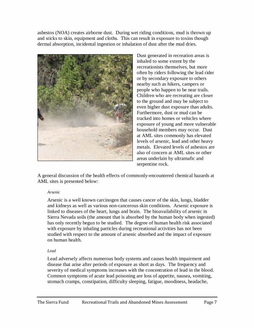
asbestos (NOA) creates airborne dust. During wet riding conditions, mud is thrown up and sticks to skin, equipment and cloths. This can result in exposure to toxins though dermal absorption, incidental ingestion or inhalation of dust after the mud dries.
Dust generated in recreation areas is inhaled to some extent by the recreationists themselves, but more often by riders following the lead rider or by secondary exposure to others nearby such as hikers, campers or people who happen to be near trails. Children who are recreating are closer to the ground and may be subject to even higher dust exposure than adults. Furthermore, dust or mud can be tracked into homes or vehicles where exposure of young and more vulnerable household members may occur. Dust at AML sites commonly has elevated levels of arsenic, lead and other heavy metals. Elevated levels of asbestos are also of concern at AML sites or other areas underlain by ultramafic and serpentine rock.
A general discussion of the health effects of commonly-encountered chemical hazards at AML sites is presented below:
Arsenic
Arsenic is a well known carcinogen that causes cancer of the skin, lungs, bladder and kidneys as well as various non-cancerous skin conditions. Arsenic exposure is linked to diseases of the heart, lungs and brain. The bioavailability of arsenic in Sierra Nevada soils (the amount that is absorbed by the human body when ingested) has only recently begun to be studied. The degree of human health risk associated with exposure by inhaling particles during recreational activities has not been studied with respect to the amount of arsenic absorbed and the impact of exposure on human health. Lead
Lead adversely affects numerous body systems and causes health impairment and disease that arise after periods of exposure as short as days. The frequency and severity of medical symptoms increases with the concentration of lead in the blood. Common symptoms of acute lead poisoning are loss of appetite, nausea, vomiting, stomach cramps, constipation, difficulty sleeping, fatigue, moodiness, headache,
The Sierra Fund Recreational Trails and Abandoned Mines Assessment Page 8
joint or muscle aches, anemia, and decreased sexual drive. Acute health poisoning from uncontrolled occupational exposures has resulted in fatalities. Asbestos
Asbestos is proven to cause asbestosis, lung cancer, pulmonary fibrosis, mesothelioma and possibly gastrointestinal, colorectal, throat, kidney, esophagus and gallbladder cancers. Asbestos has been classified as a known human carcinogen by the U.S. Department of Health and Human Services, the Environmental Protection Agency, and the International Agency for Research on Cancer (UCD, 2005). Mesothelioma is the most common form of cancer associated with asbestos exposure, and is almost always caused by inhalation of asbestos fibers. Asbestos is a group of highly fibrous minerals associated with serpentine and ultramafic rock. Minerals containing asbestos, such as chrysotile and tremolite, are found in distinct geological zones across the Sierra Nevada foothills. Serpentine and ultramafic rock from mine waste rock or quarries has been used as aggregate for road surfacing. Marc Schenker, a professor and chair of the UC Davis Department of Public Health Sciences, recently concluded that exposure to naturally occurring asbestos is linked to lung cancer and should be taken seriously (UCD, 2005). Inhalation of asbestos fibers in dust from serpentine rock or soil disturbed during recreational activities may increase a rider’s risk of serious lung diseases including asbestosis, lung cancer and mesothelioma, particularly if the rider also smokes cigarettes. Silica
Silicosis is a form of lung disease caused by inhalation of crystalline silica dust. It causes inflammation and scarring of the lungs or nodular lesions. Humans and horses breathing dust containing silica is a concern in areas that have weathered granitic rock or siliceous sandstone. Silicosis is an occupational hazard and is more common in horses than in riders. It can take up to ten years for symptoms to show, however heavy exposure can result in symptoms occurring in six months to two years. Mercury
Mercury damages the brain, nerves and the immune system. Mild mercury poisoning causes tingling in the lips, tongue, fingers and toes. In some cases, these symptoms do not appear until long after exposure. Severe mercury poisoning causes headaches, memory loss, difficulty coordinating movement and vision, dizziness, metallic taste in the mouth, muscle spasms, pain and stiffness in joints and muscles, and heart disease. The primary exposure to mercury in the Sierra is by consuming fish contaminated with mercury. The exposure to mercury through inhalation of contaminated dust is less likely through still a concern.
Empire Mine State Park in Grass Valley, California is a well documented example of an area where a mining operation left mine waste and mineralized soil which was identified as a hazard to recreationists and where extensive remedial measures were required. The

The Sierra Fund Recreational Trails and Abandoned Mines Assessment Page 9
park was created from abandoned mine lands in the City of Grass Valley where numerous small and large mines had operated from the 1850s to the 1950s. Environmental investigations directed by Cal/EPA Department of Toxic Substances Control (DTSC) in the 1990s and 2000s identified mine waste rock, mill tailings and naturally occurring soil with elevated metals concentrations exceeding hazardous waste levels. High arsenic concentrations were identified on trail surfaces used by hikers, runners, bicyclists and horseback riders. Several popular trail segments were closed, generating a high level of public concern. The subsequent remediation of the park included excavation and off haul of mine waste and soil, fencing of high risk areas and rerouting or resurfacing of trails. Similar conditions to those at Empire Mine State Park are likely present on public lands in many locations in the Sierra Nevada Region. The Tahoe National Forest prepared a Motorized Travel Management Draft Environmental Impact Statement (DEIS) dated September 2008 which is currently in the public comment period (TNF, 2008). This document reports that there are currently 96 AML sites within 100 feet of roads and motorized trails in the Tahoe National Forest. Many more AML sites that have not been identified or are mapped as being farther than 100 feet away may also impact roads and trails since mine waste from AML sites is often spread over a large area. Maps included in the DEIS provided a valuable resource for the current study. In most cases, these potentially hazardous trail surfaces have not been identified, investigated or characterized, but nonetheless may present significant risk to recreationists. A broad scale assessment of this toxic threat to public health is needed to inform users and regulatory agencies and to prioritize risk management decisions. Preliminary assessment activities such as the current assessment must cover large areas in order to identify critical locations where more detailed information can be collected through soil sampling and dust monitoring. PURPOSE AND SCOPE The purpose of this study was to learn whether recreationists may be exposed to toxins from mine waste or naturally occurring hazardous materials on public lands in the Sierra Nevada. The project consisted of the development and implementation of an assessment of recreational trails on public land near abandoned mines which may be contaminated with mine waste or naturally occurring hazardous substances. Information from the assessment was used to identify recreation areas that warrant further assessment, raise awareness about chemical hazards associated with AML sites, and advocate for a risk assessment of recreational activities at AML sites with chemical hazards. Scope The Gold Country Recreational Trails and Abandoned Mines Assessment was performed in general accordance with the Recreational Trail Survey Protocol document prepared in January 2009 (TSF, 2009). The protocol was intended to inform this assessment and to be a useful document for additional investigations to further characterize recreational

The Sierra Fund Recreational Trails and Abandoned Mines Assessment Page 10
exposure in the Sierra Nevada. The document presents a survey protocol and sampling methodology for conducting assessments. The following activities were performed as part of the Recreational Trails Assessment:
• Research local trail and abandoned mine land databases • Select target trail and recreation areas for sampling using GIS • Research recreational use patterns by interviewing users about common activities • Conduct field investigation by mapping site features, documenting observed
recreational activities, and taking surface soil samples • Coordinate laboratory analysis with chain of custody forms and quality control
criteria • Select threshold criteria based on best available science and limited recreation-
specific guidelines to determine potential contaminants of concern • Compare soil sample results to selected threshold criteria • Recommend additional field investigations and assessment of trail and recreation
areas that have chemical hazards, defined as soils samples with concentrations that are above threshold criteria
METHODOLOGY
Site Selection Recreation areas in the Sierra region in three different counties (Sierra, Nevada and Placer) were targeted for the Recreational Trails Assessment. The three general target areas included the Downieville area in Sierra County, the Nevada City area in Nevada County and the Foresthill area in Placer County. The assessment’s first step was to review available maps, documents, interviews, databases and internet sources to identify mine locations, trails, roadways, and recreation areas, and what activities were popular in the general area. Useful sources of information included the Motorized Travel Management Draft EIR for the Tahoe National Forest, which included detailed road and trail maps; the USGS Mineral Resources, Topographically Occurring Mine Symbols (TOMS), and Principal Areas of Mining Pollution (PAMP) databases; and other historic maps which identify abandoned mine locations. USGS topographic maps, recreational trail maps and guidebooks, and internet sites pertaining to recreational activities were also useful sources of information. Geographical Information Systems (GIS, Arc View 9.3) was used to identify areas where abandoned mines in the TOMS and PAMP databases were within 30 feet of a recreational trail. This type of analysis is a common GIS query, by which the mapping program to identifies the proximity of two features, in this case a trail layer and a AML feature. The proximity of 30 feet was selected to ensure that AML features adjacent to the trail were captured in the query. In general, most GPS devices are accurate to within one to ten meters, or three to thirty feet. Without using this range, the GIS analysis would only have identified AML features that overlapped with the trail exactly, potentially missing
The Sierra Fund Recreational Trails and Abandoned Mines Assessment Page 11
surrounding features that affect the tail, such as waste rock piles eroding onto the trail but was not mapped right on the trail. This query resulted in over 60 potential sites. In order to narrow down the number of selected sites, only the sites that were in the most popular recreation areas were selected for sampling. The most popular recreation areas were identified by conducting interviews with ATV, horseback, dirt bike, and mountain bike riders. These interviews were informal and typically included employees and customers at Motor Sports outlets, guide and shuttle service providers, and employees of markets near recreation areas. Based on the document research, GIS analysis, and interviews, a manageable number of sites/trail segments were selected in the Tahoe National Forest, nearby State Parks, BLM and other publicly accessible lands in the region to conduct the initial assessment. Several of the selected assessment sites were located in areas that were underlain by geologic formations with naturally occurring asbestos (NOA). Mining activities that disturbed serpentine and ultramafic rock to reach gold-bearing quartz veins may have disturbed and distributed asbestos minerals. It was not the original intent of this assessment to identify recreation areas with NOA, however when assessing chemical hazards at selected AML sites where recreation occurs it became apparent that a potentially significant human health concern was exposure to asbestos-laden dust. AML sites with NOA were included in the site assessment because dust-generating activities at these sites create a public health concern similar to heavy metal exposure.
Field Methods The selected sites were accessed by hiking, biking or four wheel drive vehicles. The goal of the site visit was to locate the AML feature that was mapped on or near the recreational trail. On site visits, researchers used field maps that were created with GIS (Arc View 9.3) and were based on USGS Topographic maps, the TOMS and PAMP databases. They also identified trails (using the DEIS Travel Management layers created by the TNF), roadways and recreation areas, and parking/staging areas. Once the site was located, researchers noted evidence of mine waste or serpentine rock on or near trails or roads, direct observations or evidence of ATV use, soil conditions and access points. Handheld recreational grade GPS units (Garmin Oregon 500) were used to mark AML features, soil sample locations, and potential high risk exposure locations. Field observations of mine features, apparent trail uses such as vehicle tracks, and frequency of use, access and trailhead locations were recorded in field notes. Observations of actual recreational use included number and type of users, dust or mud disturbance, distance between riders, and evidence of recreational use on or near mine waste or serpentine rock outcrops. Photographs were taken of significant AML features, soil sample locations and evidence of potential high risk exposure locations.
The Sierra Fund Recreational Trails and Abandoned Mines Assessment Page 12
Soil Sampling Representative surface soil sampling locations were selected on trail or roadway surfaces. Surface soil samples were taken any place where mine waste extended onto and/or adjacent to trails or ATV tracks, areas with serpentine rock, or areas where high concentrations of AML sites nearby might indicate mineralized soil. Soil samples were generally obtained from the upper one inch of soil on the trail or the top two to six inches of mine waste in areas which appeared likely to be a source of dust to recreationists.
Soil samples were collected by professional consulting geologist Kyle Leach, who has over 10 years of assessing abandoned mine sites in the northern Sierra region; and project coordinator and Science Director for The Sierra Fund, Dr. Carrie Monohan. Dr. Monohan holds a doctorate in Forest Engineering and Hydrology from the University of Washington, has been working on legacy mining contamination with The Sierra Fund since 2006, and prior to that was the project manager and principal investigator for the City of Nevada City Community Wide Brownfield Assessment, funded and advised by the Environmental Protection Agency Region 9.
Samplers wore disposable latex gloves and dust masks. A disposable plastic scoop was used to collect a four ounce surface sample from the upper six inches of soil. The sampling equipment was decontaminated between samples with a moist disposable towel, and samples were placed into double zip lock baggies and immediately labeled with sample name, type of material, location, date, and sampler. Sample name suffixes were used to identify the type of sample including: TS = trail sample, MS = mine waste sample, and SERP = serpentine. GPS coordinates were obtained (when possible) for all sample locations, and approximate sample locations were also marked on field base maps. Soil sampling data was recorded in field notebooks. The GPS locations of soil samples were mapped using GIS and are presented in Figures 2-12. Samples were placed and transported in a chilled cooler as soon as possible after collection, at the latest as soon as samplers returned to the vehicles. Samples were transported to the office for temporary storage and subsequently shipped to the analytical laboratories. Chain of custody documentation was maintained from the time the samples were collected until they were received by the analytical laboratory. Field duplicates were not collected as a part of this preliminary sampling effort, however laboratory duplicates are a standard component of the laboratory procedure as described in the ALS Quality Assurance Overview (Appendix A).
Laboratory Sample Analysis The project coordinator reviewed all sample collection data and chain of custody documents for accuracy and determined constituents of concern prior to preparing an analytical laboratory request. Samples of mine waste or naturally occurring asbestos
The Sierra Fund Recreational Trails and Abandoned Mines Assessment Page 13
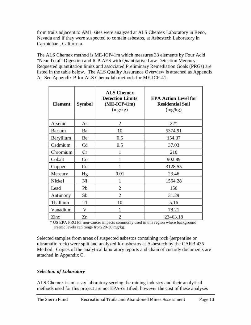
from trails adjacent to AML sites were analyzed at ALS Chemex Laboratory in Reno, Nevada and if they were suspected to contain asbestos, at Asbestech Laboratory in Carmichael, California. The ALS Chemex method is ME-ICP41m which measures 33 elements by Four Acid “Near Total” Digestion and ICP-AES with Quantitative Low Detection Mercury. Requested quantitation limits and associated Preliminary Remediation Goals (PRGs) are listed in the table below. The ALS Quality Assurance Overview is attached as Appendix A. See Appendix B for ALS Chemx lab methods for ME-ICP-41.
Element
Symbol
ALS Chemex Detection Limits (ME-ICP41m)
(mg/kg)
EPA Action Level for Residential Soil
(mg/kg) Arsenic As 2 22* Barium Ba 10 5374.91 Beryllium Be 0.5 154.37 Cadmium Cd 0.5 37.03 Chromium Cr 1 210 Cobalt Co 1 902.89 Copper Cu 1 3128.55 Mercury Hg 0.01 23.46 Nickel Ni 1 1564.28 Lead Pb 2 150 Antimony Sb 2 31.29 Thallium Tl 10 5.16 Vanadium V 1 78.21 Zinc Zn 2 23463.18
* US EPA PRG for non-cancer impacts commonly used in this region where background arsenic levels can range from 20-30 mg/kg.
Selected samples from areas of suspected asbestos containing rock (serpentine or ultramafic rock) were split and analyzed for asbestos at Asbestech by the CARB 435 Method. Copies of the analytical laboratory reports and chain of custody documents are attached in Appendix C.
Selection of Laboratory ALS Chemex is an assay laboratory serving the mining industry and their analytical methods used for this project are not EPA-certified, however the cost of these analyses
The Sierra Fund Recreational Trails and Abandoned Mines Assessment Page 14
are approximately 10% of the corresponding EPA certified Title 22 Metals analysis. The decision to have the samples from the project analyzed by ALS was based on the cost benefit in addition to a review and comparative evaluation of ALS metals results with results from an EPA laboratory. A laboratory comparison between ALS and EPA was performed in September 2007 as part of the Nevada City’s EPA Brownfields Assessment project using the results of 20 split samples which were analyzed at both ALS and an EPA laboratory. The results from the laboratory comparison are included in Appendix D. Comparison of analytical results for specific metal analytes including constituents of concern for the current project such as arsenic, lead, and chromium indicated that ALS results had consistently higher metals concentrations but the data corresponded well for most analytes of interest. Results of arsenic, chromium, nickel and mercury were within an acceptable variance range and were allowed by EPA Quality Assurance and Control to be used “as is” for the Nevada City Brownfields Assessment project. ALS results for lead were consistently higher than EPA results and thus lead results exceeding the Brownfield project goals were required to be verified by analyzing duplicate samples at an EPA-certified laboratory. Based on the results of the EPA comparative study, ALS Chemex laboratory results were considered usable for this assessment project for the purpose of evaluation of comparative health risks and to prioritize sampling locations for further study. Because the ALS results are consistently high biased, due to a stronger acid digest, the results are considered protective of human health, in that if the data are below threshold levels then there would be no threat to human health. However, analytical data used to develop future site-specific remediation projects warrant verification for specific analytes at an EPA-certified analytical laboratory.
Evaluation of Sample Results and Constituents of Concern Analytical laboratory results of soil and mine waste samples obtained during the project were reviewed and compared with various regulatory screening levels to evaluate potential constituents of concern (COCs) in project areas (Table 1). Screening levels considered included California Human Health Screening Levels (CHHSLs) prepared by Cal/EPA (Cal/EPA, 2005), Preliminary Remediation Goals (PRGs) prepared by US EPA (EPA, 2009), and Risk Management Criteria for Metals at BLM Mining Sites developed by US Department of the Interior Bureau of Land Management (BLM, 2004). The selected screening levels were not meant to be used as cleanup goals or regulatory standards without consideration of site-specific factors and exposure scenarios. Rather, they were meant to be used early in the site screening process to help identify areas that required further evaluation.
The Sierra Fund Recreational Trails and Abandoned Mines Assessment Page 15
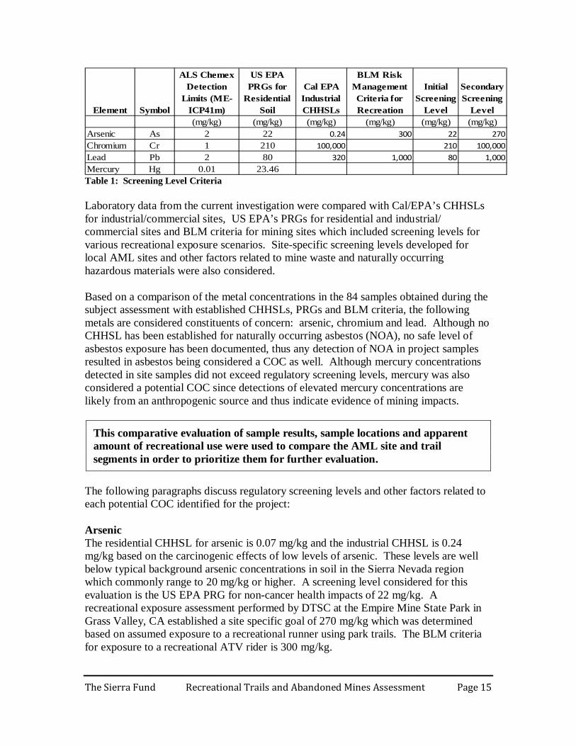
(mg/kg) (mg/kg) (mg/kg) (mg/kg) (mg/kg) (mg/kg)Arsenic As 2 22 0.24 300 22 270Chromium Cr 1 210 100,000 210 100,000Lead Pb 2 80 320 1,000 80 1,000Mercury Hg 0.01 23.46
Secondary Screening
Level SymbolElement
ALS Chemex Detection
Limits (ME-ICP41m)
US EPA PRGs for
Residential Soil
Cal EPA Industrial CHHSLs
BLM Risk Management Criteria for Recreation
Initial Screening
Level
Table 1: Screening Level Criteria Laboratory data from the current investigation were compared with Cal/EPA’s CHHSLs for industrial/commercial sites, US EPA’s PRGs for residential and industrial/ commercial sites and BLM criteria for mining sites which included screening levels for various recreational exposure scenarios. Site-specific screening levels developed for local AML sites and other factors related to mine waste and naturally occurring hazardous materials were also considered. Based on a comparison of the metal concentrations in the 84 samples obtained during the subject assessment with established CHHSLs, PRGs and BLM criteria, the following metals are considered constituents of concern: arsenic, chromium and lead. Although no CHHSL has been established for naturally occurring asbestos (NOA), no safe level of asbestos exposure has been documented, thus any detection of NOA in project samples resulted in asbestos being considered a COC as well. Although mercury concentrations detected in site samples did not exceed regulatory screening levels, mercury was also considered a potential COC since detections of elevated mercury concentrations are likely from an anthropogenic source and thus indicate evidence of mining impacts.
This comparative evaluation of sample results, sample locations and apparent amount of recreational use were used to compare the AML site and trail segments in order to prioritize them for further evaluation.
The following paragraphs discuss regulatory screening levels and other factors related to each potential COC identified for the project: Arsenic The residential CHHSL for arsenic is 0.07 mg/kg and the industrial CHHSL is 0.24 mg/kg based on the carcinogenic effects of low levels of arsenic. These levels are well below typical background arsenic concentrations in soil in the Sierra Nevada region which commonly range to 20 mg/kg or higher. A screening level considered for this evaluation is the US EPA PRG for non-cancer health impacts of 22 mg/kg. A recreational exposure assessment performed by DTSC at the Empire Mine State Park in Grass Valley, CA established a site specific goal of 270 mg/kg which was determined based on assumed exposure to a recreational runner using park trails. The BLM criteria for exposure to a recreational ATV rider is 300 mg/kg.
The Sierra Fund Recreational Trails and Abandoned Mines Assessment Page 16
This evaluation assumes the non-cancer PRG of 22 mg/kg arsenic an initial screening level and DTSC’s site-specific recreational runner exposure level of 270 mg/kg a secondary screening level. Chromium Chromium has two valence states for which CHHSLs have been established. The residential and industrial CHHSL for Trivalent Chromium (Cr3+) is 100,000 mg/kg. The residential CHHSL for Hexavalent Chromium (Cr6+) is 17 mg/kg. The industrial CHHSL for total Chromium is 37 mg/kg. This evaluation considers the US EPA PRG for total chromium of 210 mg/kg which assumes a Cr 3+ to Cr6+ ratio of 6 to 1. Cr6+ is a relatively unstable form of chromium which typically degrades to the Cr3+ state over time in the environment. Evaluations of numerous mine waste sites in the Sierra Nevada region suggest most total Chromium in mine waste is in the form of Trivalent Chromium (Cr 3+). Speciation of Chromium requires a separate analysis for Cr6+ which is relatively expensive and for the current project would require re-sampling due to a short sample hold time. Cr 6+ analysis was not performed during this investigation. However, ongoing research to speciate chromium and other metals from this project’s assessment areas is being performed by a Chico State University graduate student in coordination with this project (results anticipated by Fall 2010). This evaluation assumes the PRG for total chromium of 210 mg/kg an initial comparative screening level and the CHHSL for Cr3+ of 100,000 mg/kg a secondary comparative screening level. Lead Cal/EPA has recently lowered the residential CHHSL for lead from 150 mg/kg to 80 mg/kg. The industrial/commercial CHHSL has been lowered to 320 mg/kg. The US EPA PRG is 400 mg/kg for residential sites and 800 mg/kg for industrial/commercial sites. The BLM criteria for a camper or ATV rider is 1,000 mg/kg. This evaluation assumes the residential CHHSL of 80 mg/kg of lead an initial comparative screening level and the BLM camper or ATV driver criteria of 1,000 mg/kg a secondary comparative screening level. Asbestos No safe level of asbestos exposure has been established, thus any detection indicates a potential health risk to exposed populations. Health risk generally increases with exposure concentration. This evaluation assumes any asbestos detection an initial comparative screening level and 10% asbestos a secondary comparative screening level.
The Sierra Fund Recreational Trails and Abandoned Mines Assessment Page 17
SAMPLE RESULTS AND DISCUSSION The following sections summarize the comparative evaluation of the soil sample results to the selected screening levels for the constituents of concern. Eleven target areas selected for site visits, soil sampling and assessment are grouped into three general geographic areas: Downieville, Nevada City, and Foresthill. It is important to note that no informational signs were observed in any location that was surveyed warning about the potential presence of toxic heavy metals or naturally occurring asbestos around abandoned mines. Figure 1 (p 35) is a Project Location Map showing the eleven target areas, major roadways and population centers. Figures 2 through 12 indicate specific site investigation areas and approximate sample locations, while Tables 2-12 indicate sample results (pp 36-57).
Downieville Area
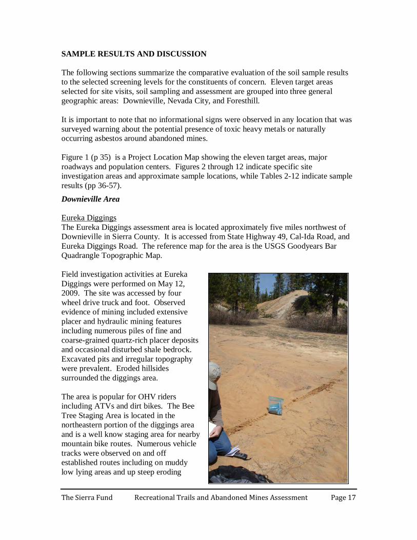
The Eureka Diggings assessment area is located approximately five miles northwest of Downieville in Sierra County. It is accessed from State Highway 49, Cal-Ida Road, and Eureka Diggings Road. The reference map for the area is the USGS Goodyears Bar Quadrangle Topographic Map.
Eureka Diggings
Field investigation activities at Eureka Diggings were performed on May 12, 2009. The site was accessed by four wheel drive truck and foot. Observed evidence of mining included extensive placer and hydraulic mining features including numerous piles of fine and coarse-grained quartz-rich placer deposits and occasional disturbed shale bedrock. Excavated pits and irregular topography were prevalent. Eroded hillsides surrounded the diggings area. The area is popular for OHV riders including ATVs and dirt bikes. The Bee Tree Staging Area is located in the northeastern portion of the diggings area and is a well know staging area for nearby mountain bike routes. Numerous vehicle tracks were observed on and off established routes including on muddy low lying areas and up steep eroding
The Sierra Fund Recreational Trails and Abandoned Mines Assessment Page 18
slopes apparently used as play areas. During the field investigation, several dirt bikers were observed in the Eureka Diggings area. Thirteen soil and mine waste samples were obtained from tracked areas on placer mine waste and low lying areas prone to mud and dust disturbance. Figure 2 is a sample location map of the area. Table 2 summarizes the results of soil sample analysis. Analytical results of the 13 samples obtained from the Eureka Diggings assessment area indicated that arsenic was detected in one sample at over 22 mg/kg but no samples exceeded 270 mg/kg. Chromium exceeded 210 mg/kg in three samples but none exceeded 100,000 mg/kg. Lead did not exceed 80 mg/kg in any sample. No samples were analyzed for NOA since no serpentine rock was observed. The results of this comparative evaluation suggest no sample locations warrant further evaluation.
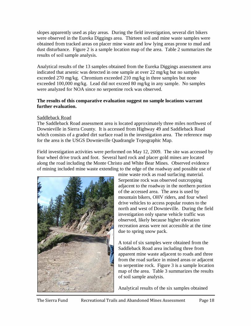
The Saddleback Road assessment area is located approximately three miles northwest of Downieville in Sierra County. It is accessed from Highway 49 and Saddleback Road which consists of a graded dirt surface road in the investigation area. The reference map for the area is the USGS Downieville Quadrangle Topographic Map.
Saddleback Road
Field investigation activities were performed on May 12, 2009. The site was accessed by four wheel drive truck and foot. Several hard rock and placer gold mines are located along the road including the Monte Christo and White Bear Mines. Observed evidence of mining included mine waste extending to the edge of the roadway and possible use of
mine waste rock as road surfacing material. Serpentine rock was observed outcropping adjacent to the roadway in the northern portion of the accessed area. The area is used by mountain bikers, OHV riders, and four wheel drive vehicles to access popular routes to the north and west of Downieville. During the field investigation only sparse vehicle traffic was observed, likely because higher elevation recreation areas were not accessible at the time due to spring snow pack. A total of six samples were obtained from the Saddleback Road area including three from apparent mine waste adjacent to roads and three from the road surface in mined areas or adjacent to serpentine rock. Figure 3 is a sample location map of the area. Table 3 summarizes the results of soil sample analysis. Analytical results of the six samples obtained
The Sierra Fund Recreational Trails and Abandoned Mines Assessment Page 19
from the Saddleback Road assessment area indicated that arsenic was detected in three samples at over 22 mg/kg but no samples exceeded 270 mg/kg (maximum of 54 mg/kg). Chromium exceeded 210 mg/kg in two samples and exceeded 1,000 mg/k in one sample but no samples exceeded 100,000 mg/kg in any sample (maximum of 1,180 mg/kg). Lead exceeded 80 mg/kg and 1,000 mg/kg in one sample (1,570 mg/kg). Asbestos was detected at 14% chrysotile in the one sample analyzed for asbestos. Based on a comparative evaluation of sample results from the Saddleback Road assessment area, lead is a COC at the sample SB-MS2 location (mine waste at the Monte Christo Mine). Asbestos is a COC at the sample SB-TS5 location (on Saddleback Road adjacent to serpentine rock outcrops in the northern portion of the assessment area).
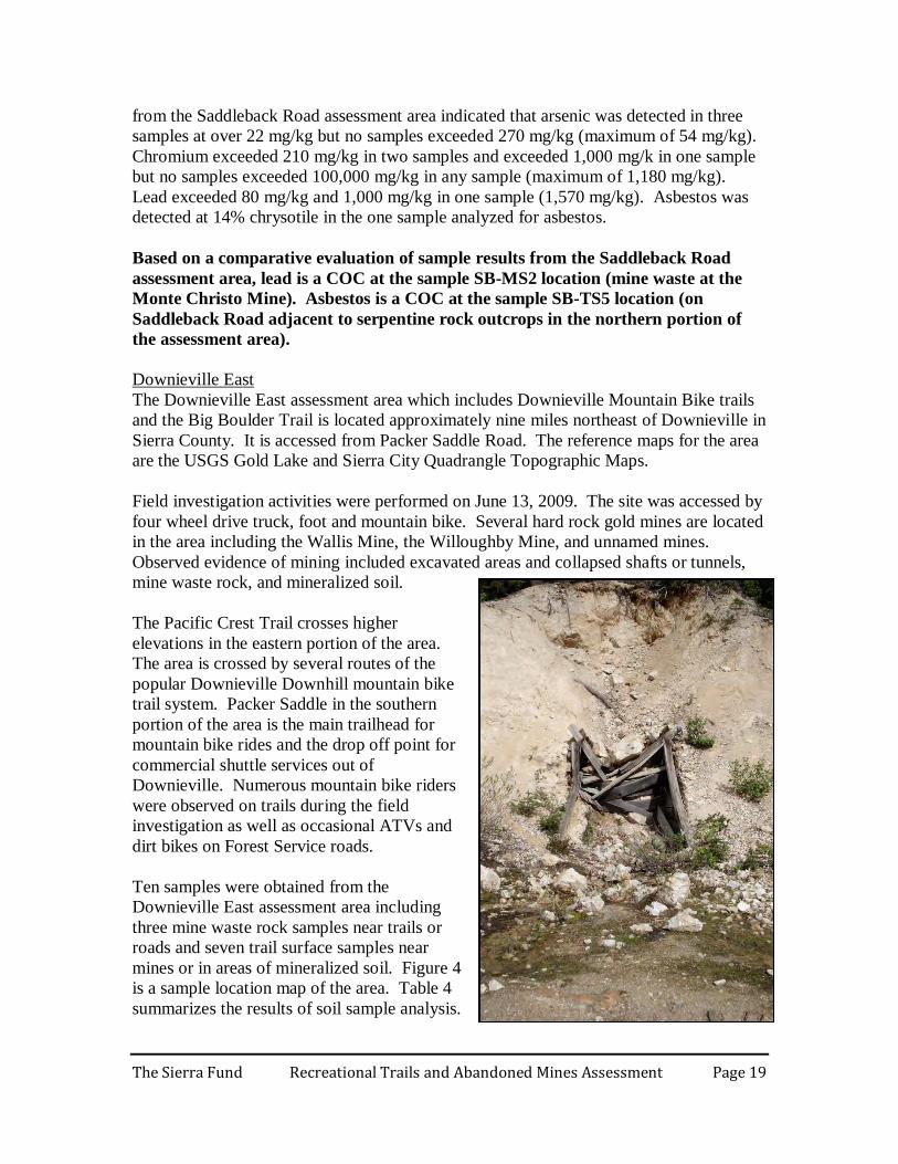
The Downieville East assessment area which includes Downieville Mountain Bike trails and the Big Boulder Trail is located approximately nine miles northeast of Downieville in Sierra County. It is accessed from Packer Saddle Road. The reference maps for the area are the USGS Gold Lake and Sierra City Quadrangle Topographic Maps.
Downieville East
Field investigation activities were performed on June 13, 2009. The site was accessed by four wheel drive truck, foot and mountain bike. Several hard rock gold mines are located in the area including the Wallis Mine, the Willoughby Mine, and unnamed mines. Observed evidence of mining included excavated areas and collapsed shafts or tunnels, mine waste rock, and mineralized soil. The Pacific Crest Trail crosses higher elevations in the eastern portion of the area. The area is crossed by several routes of the popular Downieville Downhill mountain bike trail system. Packer Saddle in the southern portion of the area is the main trailhead for mountain bike rides and the drop off point for commercial shuttle services out of Downieville. Numerous mountain bike riders were observed on trails during the field investigation as well as occasional ATVs and dirt bikes on Forest Service roads. Ten samples were obtained from the Downieville East assessment area including three mine waste rock samples near trails or roads and seven trail surface samples near mines or in areas of mineralized soil. Figure 4 is a sample location map of the area. Table 4 summarizes the results of soil sample analysis.
The Sierra Fund Recreational Trails and Abandoned Mines Assessment Page 20
Analytical results of the ten samples obtained from the Downieville East assessment area indicated that arsenic was detected in four samples at over 22 mg/kg but no samples exceeded 270 mg/kg (maximum of 66 mg/kg). Chromium did not exceeded 210 mg/kg in any of the samples. Lead exceeded 80 mg/kg in one sample but did not exceed 1,000 mg/kg in any of the samples (maximum of 963 mg/kg). No samples were analyzed for NOA since no serpentine rock was observed. Based on a comparative evaluation of sample results from the Downieville East assessment area, no COCs exceeded secondary comparative screening levels.
The Columbo Mine assessment area is located approximately two miles northwest of Sierra City in Sierra County. It is accessed from Highway 49 and Sierra Buttes Road. The reference map for the area is the USGS Sierra City Quadrangle Topographic Map.
Columbo Mine
Field investigation activities were performed on June 13, 2009. The site was accessed by two wheel drive vehicle and foot. The area is occupied by several hard rock gold mines including the Columbo Mine and the Monarch Mine. Dirt surfaced roads in the area are used by OHV and mountain bike riders. Observed evidence of mining included a mine tunnel and large piles of mine waste rock extending to the road area, some of which showed OHV tracks. Four samples were obtained from the Columbo Mine assessment area including two from trails or road surfaces adjacent to mine waste and two from mine waste in accessible areas. Figure 5 is a sample location map of the area. Table 5 summarizes the results of soil sample analysis. Analytical results of the four samples obtained from the Columbo Mine assessment area indicated that arsenic was detected in three samples at over 22 mg/kg and in two samples exceeding 270 mg/kg (maximum of 442 mg/kg). Chromium exceeded 210 mg/kg in all four of the samples but did not exceed 100,000 in any sample (maximum of 1,365 mg/kg). Lead exceeded 80 mg/kg in one sample but did not exceed 1,000 mg/kg in any sample (maximum of 129 mg/kg). No samples were analyzed for asbestos since no serpentine rock was observed. Based on a comparative evaluation of sample results from the Columbo Mine assessment area, arsenic is a COC at the sample CM-MS2 and CM-MS3 locations (mine waste rock near trails at the Columbo Mine AML site west of Sierra City).
The Downieville First Divide assessment area is located approximately one to two miles northeast of Downieville in Sierra County. It is accessed from Lavezzola Road in Downieville. The reference map for the area is the USGS Downieville Quadrangle Topographic Map.
Downieville First Divide
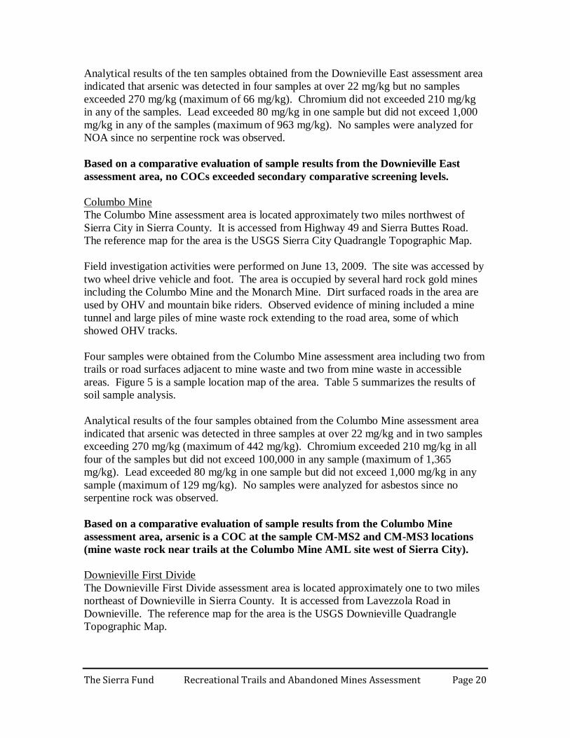
The Sierra Fund Recreational Trails and Abandoned Mines Assessment Page 21
Field investigation activities were performed on June 14, 2009. The site was accessed by two wheel drive vehicle, foot and mountain bike. Several hard rock and placer gold mines are located in the area. Observed evidence of mining included mine waste near mapped mine locations and prospects, and areas of mineralized soil. The area is located in the lower portion of the very popular Downieville Downhill mountain bike trail system where several trails merge as they near Downieville. Numerous mountain bike riders were observed on the trails, often riding in groups and traveling at high speed. Six samples were obtained from trails in the Downieville First Divide assessment area adjacent to apparent mine waste or mineralized soil. Figure 6 is a sample location map of the area. Table 6 summarizes the results of soil sample analysis. Analytical results of the six samples obtained from the Downieville First Divide assessment area indicated arsenic was detected in three samples at over 22 mg/kg but did not exceeded 270 mg/kg in any of the samples (maximum of 69 mg/kg). Chromium did
not exceeded 210 mg/kg in any of the samples. Lead did not exceeded 80 mg/kg in any of the samples. No samples were analyzed for asbestos since serpentine or ultramafic rock was not observed. Based on a comparative evaluation of sample results from the Downieville First Divide assessment area, no COCs were identified for recreational use.
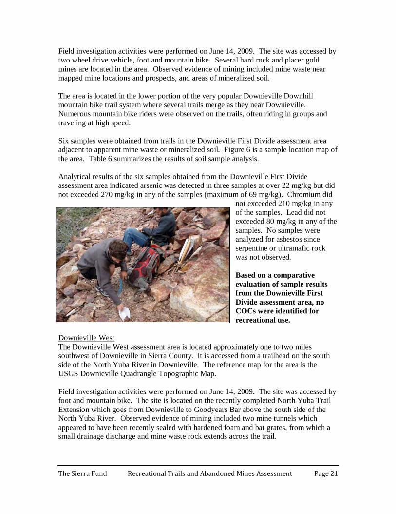
The Downieville West assessment area is located approximately one to two miles southwest of Downieville in Sierra County. It is accessed from a trailhead on the south side of the North Yuba River in Downieville. The reference map for the area is the USGS Downieville Quadrangle Topographic Map.
Downieville West
Field investigation activities were performed on June 14, 2009. The site was accessed by foot and mountain bike. The site is located on the recently completed North Yuba Trail Extension which goes from Downieville to Goodyears Bar above the south side of the North Yuba River. Observed evidence of mining included two mine tunnels which appeared to have been recently sealed with hardened foam and bat grates, from which a small drainage discharge and mine waste rock extends across the trail.
The Sierra Fund Recreational Trails and Abandoned Mines Assessment Page 22
The area is used by hikers and mountain bike riders. No riders were observed during the field visit, however a sign indicating the trail had not yet been completed may have discouraged riders. It is likely that the trail will see increased future use in the popular Downieville mountain bike trail system. Four samples were obtained from the Downieville West assessment area including two from the trail surface adjacent to mine waste, one of mine waste near the trail edge, and one from mineralized soil on the trail. Figure 7 is a sample location map of the area. Table 7 summarizes the results of soil sample analysis. Analytical results of the four samples obtained from the Downieville West assessment area indicated that arsenic was detected in three samples at over 22 mg/kg and two samples exceeded 270 mg/kg (maximum of 439 mg/kg). Chromium exceeded 210 mg/kg in one of the samples but did not exceed 100,000 mg/kg (maximum of 983mg/kg). Lead did not exceeded 80 mg/kg in any of the samples. No samples were analyzed for asbestos since no serpentine rock was observed. Based on a comparative evaluation of sample results from the Downieville West assessment area, arsenic is a COC at the SC-TS1 and SC-MS2 sample locations (trail surface and adjacent mine waste in Slug Canyon on the North Yuba Trail Extension approximately ¾ mile southwest of Downieville).
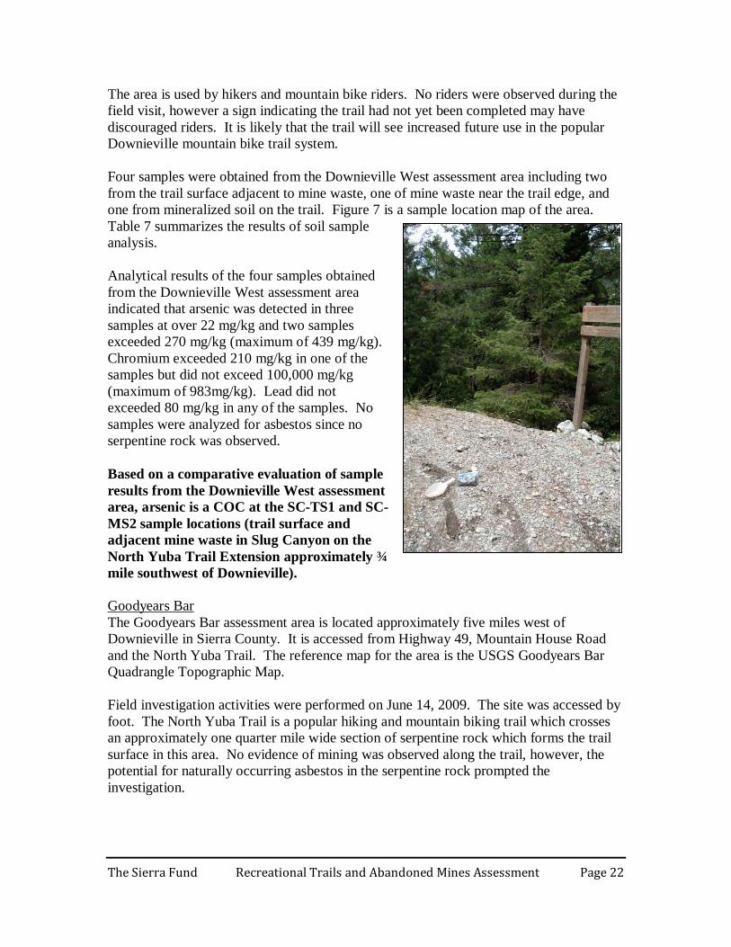
The Goodyears Bar assessment area is located approximately five miles west of Downieville in Sierra County. It is accessed from Highway 49, Mountain House Road and the North Yuba Trail. The reference map for the area is the USGS Goodyears Bar Quadrangle Topographic Map.
Goodyears Bar
Field investigation activities were performed on June 14, 2009. The site was accessed by foot. The North Yuba Trail is a popular hiking and mountain biking trail which crosses an approximately one quarter mile wide section of serpentine rock which forms the trail surface in this area. No evidence of mining was observed along the trail, however, the potential for naturally occurring asbestos in the serpentine rock prompted the investigation.
The Sierra Fund Recreational Trails and Abandoned Mines Assessment Page 23
Two samples were obtained for serpentine soil and fractured rock on the North Yuba Trail surface. Figure 8 is a sample location map of the area. Table 8 summarizes the results of soil sample analysis. Analytical results of the two samples obtained from the Goodyears Bar assessment area indicated arsenic was not detected in any of the samples at over 22 mg/kg. Chromium exceeded 210 mg/kg but did not exceed 100,000 mg/kg in either sample (maximum of 1,835 mg/kg). Lead did not exceeded 80 mg/kg in any of the samples. Asbestos was detected in both samples at 15% chrysotile and 11% chrysotile. Based on a comparative evaluation of sample results from the Goodyears Bar assessment area, chrysotile asbestos is a COC at the DV-TS8 SERP and DV-TS9 sample locations (North Yuba Trail approximately one half mile west of Mountain House Road).
Nevada City Area
The Nevada City West assessment area includes several individual areas to the north and west of Nevada City including the Tribute Trail, Newtown Ditch Trail, relatively new trails in the Manzanita Diggings area and trails in the Round Mountain area. These areas are accessed from Champion Mine Road (Tribute and Newtown Ditch), State Highway 20 (Manzanita Diggings) and Rock Creek Road (Round Mountain). The reference map for the area is the USGS Nevada City Quadrangle Topographic Map.
Nevada City West
Field investigation activities were performed on August 3 and 4, 2009. The sites were accessed by two wheel drive vehicle, foot and mountain bike. Trails in the area are popular and used by hikers, mountain bikers and horseback riders. Numerous hard rock, placer and hydraulic gold mines are located in the Nevada City assessment areas. Observed evidence of mining included hard rock mine waste rock adjacent to the Tribute Trail, hydraulic and placer mine waste in the Manzanita Diggings and mine prospect excavations and mounded soil adjacent to the Round Mountain Trail. Serpentine and ultramafic rock outcrops were observed along the Newtown Ditch Trail. Eleven samples were obtained from the Nevada City West assessment areas including two trail surface samples adjacent to apparent mine waste on the Tribute Trail, three trail samples adjacent to serpentine or ultramafic rock on the Newtown Ditch Trail, three trail samples and one placer mine waste sample on the Manzanita Diggings and two trail samples at mine prospects on the Round Mountain Trail. Figure 9 is a sample location map of the area. Table 9 summarizes the results of soil sample analysis. Analytical results of the 11 samples obtained from the Nevada City West assessment area indicated that arsenic was detected in three of the samples at over 22 mg/kg but did not exceed 270 mg/kg in any of the samples (maximum of 49 mg/kg). Chromium exceeded 210 mg/kg but did not exceed 100,000 in any sample (maximum of 2,370 mg/kg). Lead
The Sierra Fund Recreational Trails and Abandoned Mines Assessment Page 24
did not exceeded 80 mg/kg in any of the samples. Asbestos was detected in both samples analyzed for asbestos at 15% tremolite and 10% tremolite. Based on a comparative evaluation of sample results from the Nevada City West assessment area, tremolite asbestos is a COC at the NC-TS20 and NC-TS22 sample locations along the Newtown Ditch Trail.
The Nevada City East assessment area includes several trails and adjacent areas including the Gracie Mine, Cascade Ditch and Banner Mountain. These trails are located within approximately one to two miles southeast of Nevada City and are accessed by Gracie Road and Banner Mountain Trail. The reference maps for the area are the USGS Grass Valley and Chicago Park Quadrangle Topographic Maps.
Nevada City East
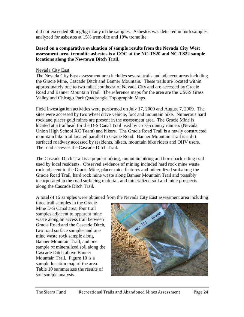
Field investigation activities were performed on July 17, 2009 and August 7, 2009. The sites were accessed by two wheel drive vehicle, foot and mountain bike. Numerous hard rock and placer gold mines are present in the assessment area. The Gracie Mine is located at a trailhead for the D-S Canal Trail used by cross-country runners (Nevada Union High School XC Team) and hikers. The Gracie Road Trail is a newly constructed mountain bike trail located parallel to Gracie Road. Banner Mountain Trail is a dirt surfaced roadway accessed by residents, hikers, mountain bike riders and OHV users. The road accesses the Cascade Ditch Trail. The Cascade Ditch Trail is a popular hiking, mountain biking and horseback riding trail used by local residents. Observed evidence of mining included hard rock mine waste rock adjacent to the Gracie Mine, placer mine features and mineralized soil along the Gracie Road Trail, hard rock mine waste along Banner Mountain Trail and possibly incorporated in the road surfacing material, and mineralized soil and mine prospects along the Cascade Ditch Trail. A total of 15 samples were obtained from the Nevada City East assessment area including three trail samples in the Gracie Mine D-S Canal area, four trail samples adjacent to apparent mine waste along an access trail between Gracie Road and the Cascade Ditch, two road surface samples and one mine waste rock sample along Banner Mountain Trail, and one sample of mineralized soil along the Cascade Ditch above Banner Mountain Trail. Figure 10 is a sample location map of the area. Table 10 summarizes the results of soil sample analysis.
The Sierra Fund Recreational Trails and Abandoned Mines Assessment Page 25
Analytical results of the 15 samples obtained from the Nevada City East assessment area indicated that arsenic was detected in 11 of the samples at over 22 mg/kg and exceed 270 mg/kg in two of the samples (maximum of 4,050 mg/kg). Chromium did not exceeded 210 mg/kg in any of the samples. Lead exceeded 80 mg/kg in one sample but did not exceed 1,000 mg/kg in any sample (maximum of 90 mg/kg). No samples were analyzed for asbestos since no serpentine rock was observed. Based on a comparative evaluation of sample results from the Nevada City East assessment area, arsenic is a COC at the NC-TS24 and NC-TS25 sample locations (dirt road surface on Banner Mountain Trail and mine waste at the top of a steep slope between the road and Little Deer Creek approximately 2.5 miles southeast of Nevada City).
Foresthill Area
The Foresthill OHV Area is located approximately eight miles northeast of Foresthill in Placer County. It is accessed from Foresthill Divide Road and Sugar Pine Road or Finning Mine Road and the Sugar Pine Staging Area. The reference maps for these areas are the USGS Foresthill and Dutch Flat Quadrangle Topographic Maps.
Foresthill OHV Area
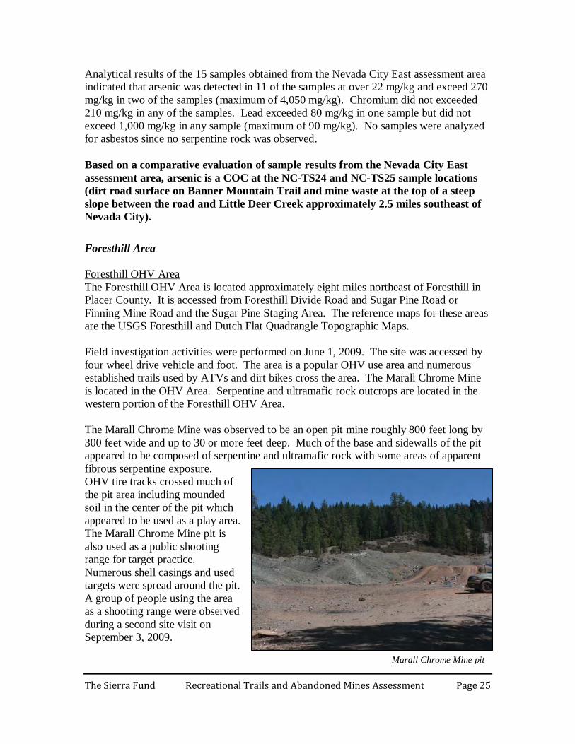
Field investigation activities were performed on June 1, 2009. The site was accessed by four wheel drive vehicle and foot. The area is a popular OHV use area and numerous established trails used by ATVs and dirt bikes cross the area. The Marall Chrome Mine is located in the OHV Area. Serpentine and ultramafic rock outcrops are located in the western portion of the Foresthill OHV Area. The Marall Chrome Mine was observed to be an open pit mine roughly 800 feet long by 300 feet wide and up to 30 or more feet deep. Much of the base and sidewalls of the pit appeared to be composed of serpentine and ultramafic rock with some areas of apparent fibrous serpentine exposure. OHV tire tracks crossed much of the pit area including mounded soil in the center of the pit which appeared to be used as a play area. The Marall Chrome Mine pit is also used as a public shooting range for target practice. Numerous shell casings and used targets were spread around the pit. A group of people using the area as a shooting range were observed during a second site visit on September 3, 2009.
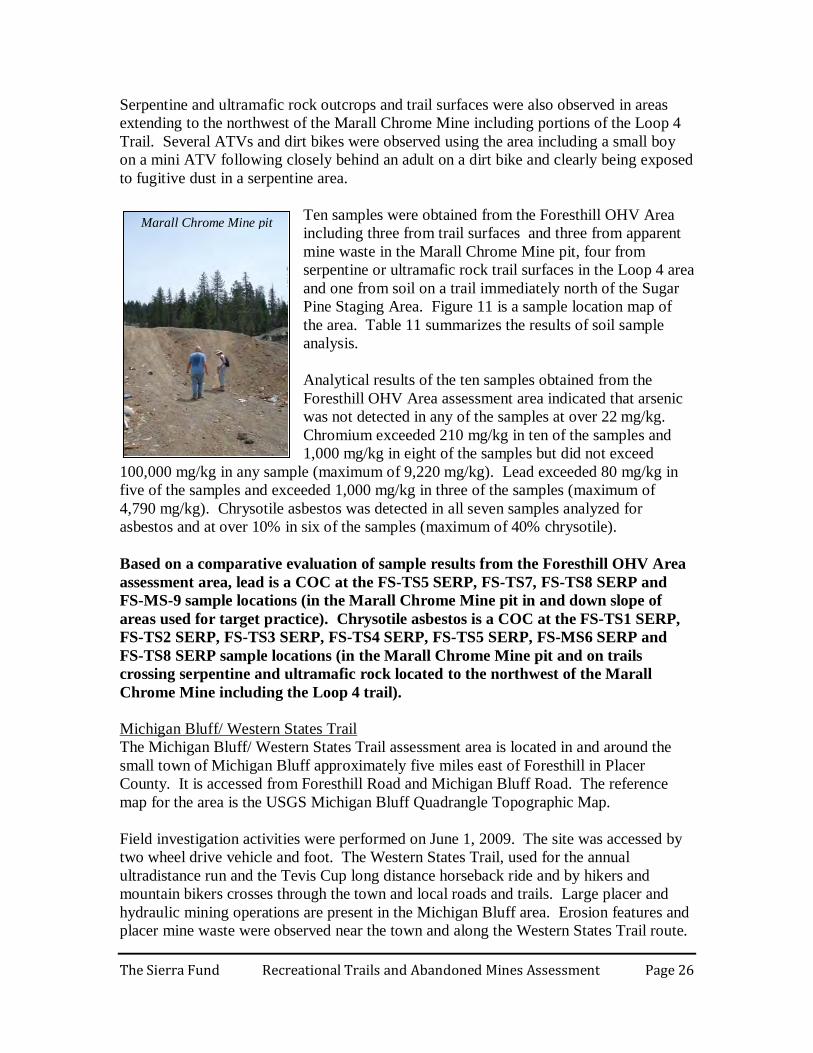
Marall Chrome Mine pit
The Sierra Fund Recreational Trails and Abandoned Mines Assessment Page 26
Serpentine and ultramafic rock outcrops and trail surfaces were also observed in areas extending to the northwest of the Marall Chrome Mine including portions of the Loop 4 Trail. Several ATVs and dirt bikes were observed using the area including a small boy on a mini ATV following closely behind an adult on a dirt bike and clearly being exposed to fugitive dust in a serpentine area.
Ten samples were obtained from the Foresthill OHV Area including three from trail surfaces and three from apparent mine waste in the Marall Chrome Mine pit, four from serpentine or ultramafic rock trail surfaces in the Loop 4 area and one from soil on a trail immediately north of the Sugar Pine Staging Area. Figure 11 is a sample location map of the area. Table 11 summarizes the results of soil sample analysis. Analytical results of the ten samples obtained from the Foresthill OHV Area assessment area indicated that arsenic was not detected in any of the samples at over 22 mg/kg. Chromium exceeded 210 mg/kg in ten of the samples and 1,000 mg/kg in eight of the samples but did not exceed
100,000 mg/kg in any sample (maximum of 9,220 mg/kg). Lead exceeded 80 mg/kg in five of the samples and exceeded 1,000 mg/kg in three of the samples (maximum of 4,790 mg/kg). Chrysotile asbestos was detected in all seven samples analyzed for asbestos and at over 10% in six of the samples (maximum of 40% chrysotile). Based on a comparative evaluation of sample results from the Foresthill OHV Area assessment area, lead is a COC at the FS-TS5 SERP, FS-TS7, FS-TS8 SERP and FS-MS-9 sample locations (in the Marall Chrome Mine pit in and down slope of areas used for target practice). Chrysotile asbestos is a COC at the FS-TS1 SERP, FS-TS2 SERP, FS-TS3 SERP, FS-TS4 SERP, FS-TS5 SERP, FS-MS6 SERP and FS-TS8 SERP sample locations (in the Marall Chrome Mine pit and on trails crossing serpentine and ultramafic rock located to the northwest of the Marall Chrome Mine including the Loop 4 trail).
The Michigan Bluff/ Western States Trail assessment area is located in and around the small town of Michigan Bluff approximately five miles east of Foresthill in Placer County. It is accessed from Foresthill Road and Michigan Bluff Road. The reference map for the area is the USGS Michigan Bluff Quadrangle Topographic Map.
Michigan Bluff/ Western States Trail
Field investigation activities were performed on June 1, 2009. The site was accessed by two wheel drive vehicle and foot. The Western States Trail, used for the annual ultradistance run and the Tevis Cup long distance horseback ride and by hikers and mountain bikers crosses through the town and local roads and trails. Large placer and hydraulic mining operations are present in the Michigan Bluff area. Erosion features and placer mine waste were observed near the town and along the Western States Trail route.
Marall Chrome Mine pit
The Sierra Fund Recreational Trails and Abandoned Mines Assessment Page 27
Three samples were obtained from the Michigan Bluff/ Western States Trail assessment area including trail surfaces adjacent to placer mine features in the Michigan Bluff area and near a mapped AML site on the Foresthill Divide Loop Trail. Figure 12 is a sample location map of the area. Table 12 summarizes the results of soil sample analysis. Analytical results of the three samples obtained from the Michigan Bluff/ Western States Trail assessment area indicated arsenic was detected in one of the samples at over 22 mg/kg but did not exceed 270 mg/kg in any samples. Chromium exceeded 210 mg/kg in two of the samples but did not exceed 100,000 mg/kg in any of the samples (maximum of 375 mg/kg). Lead did not exceeded 80 mg/kg in any of the samples. No samples were analyzed for asbestos since no serpentine rock was observed. Based on a comparative evaluation of sample results from the Michigan Bluff/ Western States Trail assessment area, no COCs were identified. SUMMARY AND RECOMENDATIONS The 2009 Recreational Trails and Abandoned Mine Assessment of mine waste and naturally occurring asbestos areas identified contaminants of concern (COC) in popular recreation areas. Comparison of soil sample results with various screening levels established by State and Federal Agencies identified arsenic, lead and asbestos as COCs associated with recreational activities near particular abandoned mines in the Sierra Region. The following specific locations in Downieville, Nevada City and Foresthill were identified as having constituents of concern above the secondary screening level and therefore present a potential threat to recreationists.
Summary of Results
• In the Saddleback Road assessment area (Figure 3), lead is a COC in mine waste at the Monte Christo Mine (sample SB-MS2 location). Asbestos is a COC along Saddleback Road adjacent to serpentine rock outcrops in the northern portion of the assessment area (SB-TS5 location).
Downieville Area
• In the Columbo Mine assessment area (Figure 5), arsenic is a COC in mine waste
rock near trails at the Columbo Mine AML site west of Sierra City (sample CM-MS2 and CM-MS3 locations).
• In the Downieville West assessment area (Figure 7), arsenic is a COC for the trail
surface and adjacent mine waste in Slug Canyon on the North Yuba Trail Extension approximately ¾ mile southwest of Downieville (sample SC-TS1 and SC-MS2 locations).
The Sierra Fund Recreational Trails and Abandoned Mines Assessment Page 28
• In the Goodyears Bar assessment area (Figure 8), chrysotile asbestos is a COC along the North Yuba Trail approximately one half to one mile west of Mountain House Road (sample DV-TS8 SERP and DV-TS9 locations).
• In the Nevada City West assessment area (Figure 9), tremolite asbestos is a COC along the Newtown Ditch trail (sample NC-TS20 and NC-TS22 locations).
Nevada City Area
• In the Nevada City East assessment area (Figure 10), arsenic is a COC on the dirt
road surface on Banner Mountain Trail and mine waste above Little Deer Creek approximately 2.5 miles southeast of Nevada City (sample NC-TS24 and NC-TS25 locations).
• In the Foresthill OHV Area assessment area (Figure 11), lead is a COC in the Marall Chrome Mine pit in and down slope of areas used for target practice (sample FS-TS5 SERP, FS-TS7, FS-TS8 SERP and FS-MS-9 locations). Chrysotile asbestos is a COC in the Marall Chrome Mine pit and on trails crossing serpentine and ultramafic rock located to the northwest of the Marall Chrome Mine including the Loop 4 trail (sample FS-TS1 SERP, FS-TS2 SERP, FS-TS3 SERP, FS-TS4 SERP, FS-TS5 SERP, FS-MS6 SERP and FS-TS8 SERP locations).
Foresthill Area
Recommendations Results from the Recreational Trails and Abandoned Mines Assessment show an urgent need for the following measures:
1. Clear, visible advisories in areas that are known to be contaminated 2. Additional sampling of contaminated areas using EPA-certified laboratories 3. A dust exposure study that considers exposure scenarios of different recreational
activities 4. A survey of recreationists to inform outreach to populations at risk of being
exposed to contaminated dust during recreational activities in the Gold Country Posted Warnings about Risk of Dusty Activities Where dangerous levels of heavy metals or naturally occurring asbestos (NOA) have been found around trails that go through abandoned mines on public land, informational notices of the presence of these hazards should be immediately posted. Simple, clear and compelling public information materials need to be created and displayed on trails and trail staging areas in these areas. This information should also be added to websites, maps and other public education materials created by the public agency that is responsible for managing the lands around abandoned mines that have been to have contaminants of concern on site.
The Sierra Fund Recreational Trails and Abandoned Mines Assessment Page 29
In particular, the trails around the Marall Mine should be posted immediately so people recreating in the area are aware of the high levels of lead, arsenic and naturally occurring asbestos on and around the trails. Additional Sampling Additional sampling and assessment efforts are recommended in areas where contaminants of concern were detected above secondary screening levels. Screening levels were not meant to be used as cleanup goals or regulatory standards but were meant to inform future sampling efforts. Site specific factors and exposure scenarios influence regulatory and human health thresholds of different contaminants. This analysis is meant to be used as a preliminary screening process to help determine sites with potential constituents of concern that are in need of further evaluation. Additional soil sampling and analysis is needed in order to confirm preliminary results and to provide more detailed and comprehensive information to inform risk management decisions. Specific areas where additional sampling and analysis is recommended include:
• Additional lead sampling in the Marall Chrome Mine pit and down slope areas is warranted to define the extent of lead contamination and whether impacts to Pagge Creek are occurring. Additional lead analysis should be performed using EPA laboratory methods since the ALS Chemex laboratory has a high bias for lead analysis.
• Additional sampling and analysis for naturally occurring asbestos is warranted in
areas of the Foresthill OHV Area, particularly in areas surrounding the Marall Chrome Mine, along Loop 4 trail and in other areas underlain by serpentine and ultramafic rock.
• Other areas warranting additional NOA sampling include areas along Saddleback
Road in the Downieville area, the North Yuba Trail in the Goodyears Bar area, and the Newtown Ditch Trail in the Nevada City area.
• Areas warranting additional sampling for arsenic include the dirt road surface of
Banner Mountain Trail in the Nevada City area, and mine waste at the Columbo Mine site in the Downieville area. Arsenic detected in the Slug Canyon area of the North Yuba Trail Extension near Downieville is apparently limited in extent and along a new, moderately used trail and thus may be less of a priority for additional investigation.
Additional samples should be analyzed at an EPA-certified lab and the results used to inform the development of a risk assessment for specific sites. Sites with a significant risk to human health will need remediation action plans approved by the California Department of Toxic Substances Control (DTSC). Future field sampling efforts should include 10% field duplicates.
The Sierra Fund Recreational Trails and Abandoned Mines Assessment Page 30
Dust Exposure Study During recreational activities, the primary exposure routes to contaminants in mine waste are likely through inhalation of dust and dermal contact. Dust monitoring is recommended to quantify dust exposure to specific COCs for recreational activities at the sites identified above so that a risk assessments and remediation action plans can be developed for high risk sites. A dust exposure study should show whether different types of recreational activities result in different levels of dust exposure. Understanding the dust generated in different exposure scenarios will help quantify the levels of exposure to different user groups and can be used to inform the creation of a remediation action plan.
• It may be that OHVs generate the most dust among recreationists due to their higher rate of travel, tire surface area, and vehicle weight.
• Horseback riders report the amount of dust generated varies considerably from horse to horse since some horses kick up more dust than others. Horses generally kick up the most dust during downhill riding and lead horse riders are often exposed to dust due to the relatively slow rate of travel.
• Hikers and campers generate relatively little dust but may be exposed to dust from
other recreationists’ activities in high use or multiple use areas. Recreationists who camp near dusty areas are potentially exposed to elevated levels of contaminated dust because dust plumes linger and drift with prevailing air currents, prolonging exposure time and areal extent. DTSC’s dusty road study found asbestos dust remained airborne after all visible dust had attenuated (DTSC, 2005).
In addition, understanding the effectiveness of precautionary measures, such as dust masks or increasing the distance between riders, is an important component of a dust study and may help protect sensitive populations. Children on small ATVs were observed riding within the dust cloud of leading adults. Riders who follow ATVs or dirt bikes may be exposed to more dust than the lead rider and increasing the distance between riders may reduce dust exposure. Dust masks or other dust breathing protection may also help reduce exposure to contaminated dust. Dust monitoring activities should be performed by qualified professionals with adequate health and safety training and protective equipment. In preliminary discussions, DTSC staff have expressed interest in advising, assisting, or participating in future dust monitoring activities identified by this study. County staff should also be consulted and included prior to a dust exposure study at AML sites in the Sierra. The results from a dust study, including both recreational activities resulting in the highest risk of exposure and the effectiveness of precautionary measures, is a critical component of a comprehensive risk assessment.
The Sierra Fund Recreational Trails and Abandoned Mines Assessment Page 31
Survey of Recreationists A survey of recreationists is recommended for areas identified in this study, as well as in other areas of the Sierra where recreational activities may result in human exposure to mine toxins or naturally occurring asbestos. Interview questions which may be included in a Recreationist Survey include:
o How often do you ride? o Where do you ride? o How long do you ride each time? o Do you ride in groups, how may in a group, how far apart do you ride? o Do you use dust protection? o What time of year is dust most prevalent? o Are you aware of toxins in mine waste, asbestos and their related health issues?
Surveys should focus on the highest risk activities including OHV use, horseback riding and to a lesser extent mountain bike riding. Survey interviews should be conducted at any location where willing participants can be located. Because of the transient nature of the target use groups, promising locations for the survey interviews include local staging areas or parking areas where ATV trailers, vehicles with bike racks or horse trailers are known to park such as the Sugar Pine Staging Area in the Foresthill OHV Area and trailheads for the Newtown Ditch Trail and North Yuba Trail. It is anticipated that some groups or individuals may not cooperate with a direct survey, particularly those who are concerned with potential trail closures or who may be riding illegally in closed areas. In this case, remote survey methods, such as trip cameras, could be considered as an alternative method to collecting user frequency information. The Recreationist Survey should also include visits to staging areas during times of high use, vehicle counts. Observers could be stationed with cameras at target areas to document actual use conditions such as amount of trail or off-trail travel, contact with mine waste, visual dust disturbance, group use and distance between riders and how long airborne dust lingers. Recreational use assessments and user surveys should considered for other areas of the Sierra Nevada where high densities of AML sites or naturally occurring asbestos and recreational trails overlap. Locations for future surveys could include other National Forests such as the Plumas National Forest and Eldorado National Forest. The results of the recreationist survey can be used to inform site-specific risk assessment calculations, especially for arsenic. Results will also help develop effective outreach and education programs for recreationists to raise awareness about the dangers of mining toxins and preventative measures to reduce or minimize exposure, and perhaps most importantly specific areas to avoid.

The Sierra Fund Recreational Trails and Abandoned Mines Assessment Page 32
REFERENCES Bureau of Land Management (BLM). (2004). Risk Management Criteria for Metals at
BLM Mining Sites. Technical note 390 rev. October 2004. California Department of Conservation (CDOC). (2000). California’s Abandoned
Mines: A Report on the Magnitude and Scope of the Issue in the State. Volumes I &II. Department of Conservation.
California Department of Toxic Substances Control (DTSC) 2005, Study of airborne
asbestos from a serpentine road in Garden Valley, California: Sacramento, California, California Environmental Protection Agency, 48 p.
California Environmental Protection Agency (Cal/EPA). (2009). Use of California
Human Health Screening Levels (CHHSLs) in Evaluation of Contaminated Properties. California Environmental Protection Agency, January 2005.
Environmental Protection Agency (EPA). (2009). Risk Assessment Guidance for
Superfund (RAGS). Identification of Preliminary Remediation Goals. http://www.epa.gov/reg3hwmd/risk/human/rb-concentration_table/Generic_Tables/xls/composite_sl_table_run_DECEMBER2009.xls
Tahoe National Forest (TNF). (2008). Motorized Travel Management Draft EIR for the
Tahoe National Forest. September 2008. http://www.fs.fed.us/r5/tahoe/projects_plans/ohv_inv/DEIS_overview.shtml
The Sierra Fund (TSF). (2009). Northern Sierra Recreational Exposure Assessment and
User Survey Protocol. January 2009. The Sierra Fund (TSF). (2008). Mining’s Toxic Legacy: An Initiative to Address Mining
Toxins in the Sierra Nevada. March 2008.
University of California at Davis (UCD). (2005). Naturally Occurring Asbestos Linked to Lung Cancer. http://www.ucdmc.ucdavis.edu/newsroom/releases/archives/cancer/2005/asbestos_cancer7-2005.htm
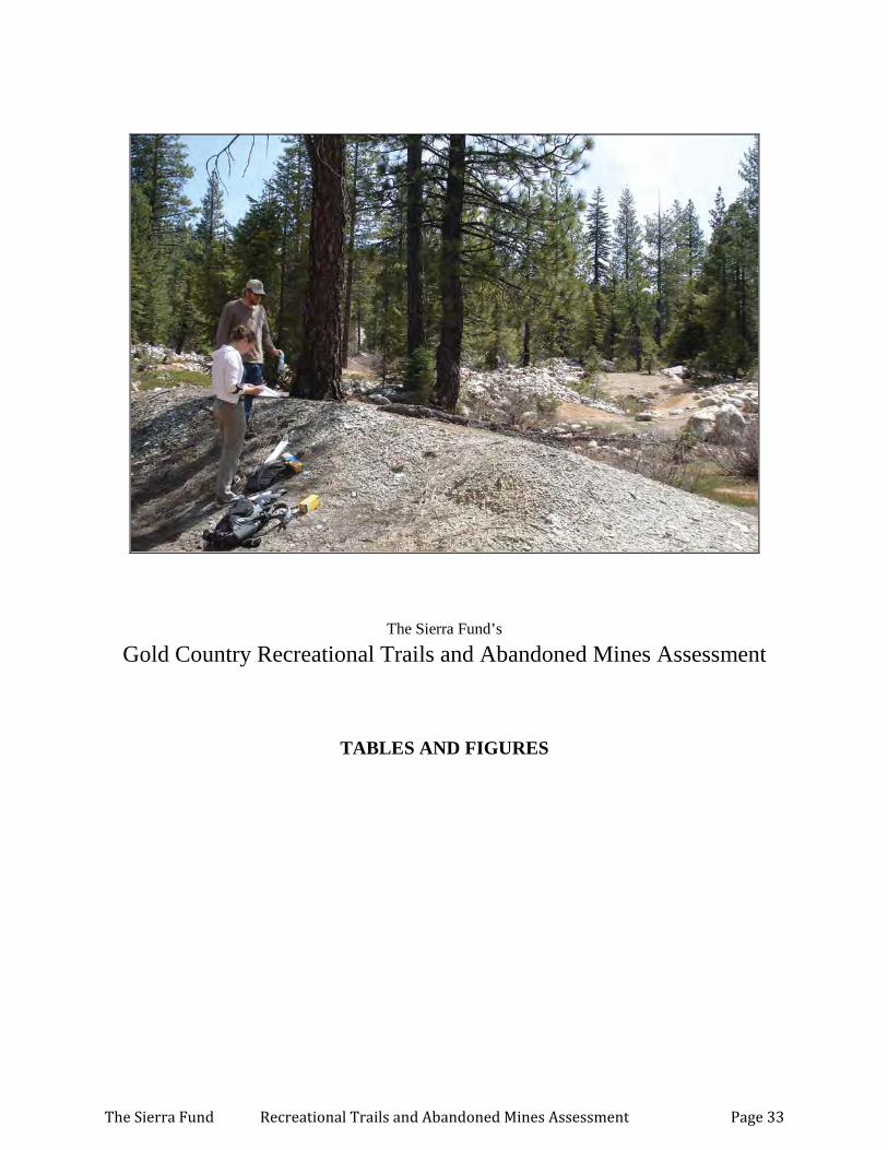
The Sierra Fund’s
Gold Country Recreational Trails and Abandoned Mines Assessment
TABLES AND FIGURES
The Sierra Fund Recreational Trails and Abandoned Mines Assessment Page 33

INDEX OF TABLES AND FIGURES
TABLE TITLE PAGE
Figure 1 Project Location Map 35
Figure 2 Eureka Diggings Map 36
Table 2 Eureka Diggings Sample Results 37
Figure 3 Saddleback Road Map 38
Table 3 Saddleback Road Sample Results 39
Figure 4 Downieville East Map 40
Table 4 Downieville East Sample Results 41
Figure 5 Columbo Mine Map 42
Table 5 Columbo Mine Sample Results 43
Figure 6 Downieville First Divide Trail Map 44
Table 6 Downieville First Divide Sample Results 45
Figure 7 Downieville West Map 46
Table 7 Downieville West Sample Results 47
Figure 8 Goodyears Bar Map 48
Table 8 Goodyears Bar Sample Results 49
Figure 9 Nevada City West Map 50
Table 9 Nevada City West Sample Results 51
Figure 10 Nevada City East Map 52
Table 10 Nevada City East Sample Results 53
Figure 11 Foresthill OHV Area Map 54
Table 11 Foresthill OHV Area Sample Results 55
Figure 12 Michigan Bluff/Western States Trail Map 56
Table 12 Michigan Bluff/Western States Trail Sample Results 57
The Sierra Fund Recreational Trails and Abandoned Mines Assessment Page 34
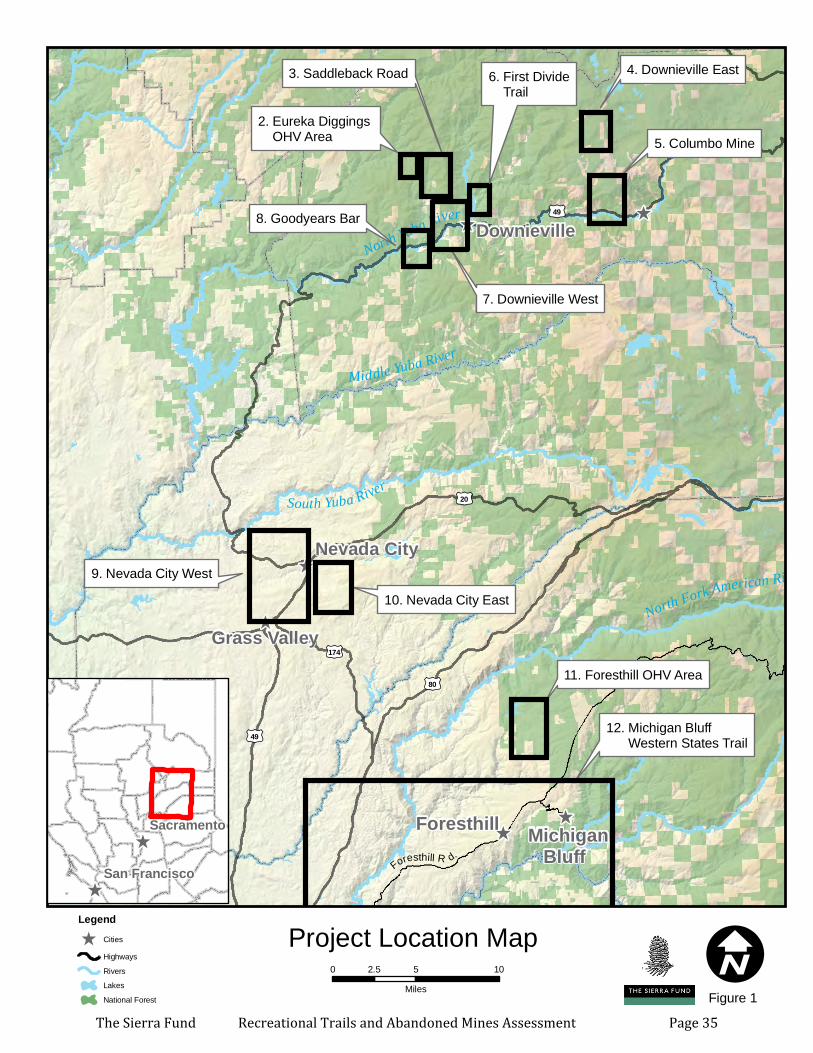
^
^
^
^
^
^
2. Eureka Diggings OHV Area
3. Saddleback Road
11. Foresthill OHV Area
12. Michigan Bluff Western States Trail
5. Columbo Mine
9. Nevada City West10. Nevada City East
Foresthill Michigan Bluff
North Yuba River
South Yuba River
Middle Yuba River
North Fork American River
Bear River
£¤49
£¤20
£¤80
£¤174
£¤89
£¤49
Grass Valley
Downieville
Nevada City
I0 5 102.5Miles
Project Location Map
4. Downieville East6. First Divide Trail
7. Downieville West
Legend^ Cities
HighwaysRiversLakesNational Forest
8. Goodyears Bar
^
^
Sacramento
San Francisco Foresthill R d.
Figure 1The Sierra Fund Recreational Trails and Abandoned Mines Assessment Page 35
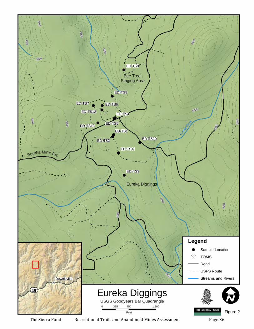
Ç
ÇÇÇ
Ç
Ç
Ç
Ç
Ç
ÇÇ
ÇÇ
Ç
Ç ÇÇÇÇÇ
ÇÇ
Ç
Ç
Ç
ÇÇÇÇÇ
Ç Ç ÇÇ
Ç
Ç
Ç Ç
ÇÇ
Ç Ç
ÇÇÇ
ÇÇÇÇÇ
Ç
Ç
Ç
Ç
ÇÇ
Ç
Ç
ÇÇ
ÇÇ
ÇÇ
Ç
Ç
Ç
Ç
ÇÇ
Ç
Ç
ÇÇ
Ç
ÇÇÇÇ
ÇÇ
Ç
ÇÇ
ÇÇ
Ç
ÇÇ
Ç
Ç
Ç
ÇÇ
ÇÇÇ
ÇÇÇ
Ç
Ç
Ç
ÇÇ
ÇÇ
Ç
ÇÇ
!!
!
!!
!
!
!
!
!
!
!
!
Eureka Mine Rd.
ED-TS9
ED-TS8
ED-TS6
ED-TS5
ED-TS4
ED-TS3
ED-TS2
ED-TS1ED-TS13
ED-TS11
ED-TS10
ED-TS7ED-TS12
Eureka Diggings
5200
5000
5400
4800
4800
5000
5000
5000
5400
5200
5000
5200
520052
00
5000
5200
5200
5400
Eureka
Creek
I0 750 1,500375
Feet
Eureka Diggings^
£¤49
Downieville
USGS Goodyears Bar Quadrangle
Legend! Sample LocationÇ TOMS
RoadUSFS RouteStreams and Rivers
Figure 2
Bee Tree Staging Area
The Sierra Fund Recreational Trails and Abandoned Mines Assessment Page 36
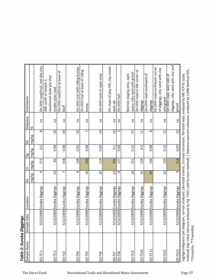
Tabl
e 2:
Eur
eka
Dig
ging
sSa
mpl
e N
ame
Sam
ple
Dat
eLo
catio
nA
sCr
Hg
PbA
sbes
tos
Com
men
tsm
g/kg
mg/
kgm
g/kg
mg/
kg%
ED-T
S 1
5/12
/200
9Eu
reka
Dig
ging
s9
171
0.1
8na
On
OH
V ro
ad/t
rail,
red
silt
y cl
ay
ED-T
S 2
5/12
/200
9Eu
reka
Dig
ging
s13
850.
0410
na
20ft
sou
th o
f sam
ple
1,
wea
ther
ed s
hale
pile
that
er
odes
ont
o ro
ad
ED-T
S35/
12/2
009
Eure
ka D
iggi
ngs
715
80.
0820
naO
n O
HV
road
/tra
il at
bas
e of
bl
uff
ED-T
S45/
12/2
009
Eure
ka D
iggi
ngs
913
80.
0320
naO
n O
HV
trai
l with
rid
ing
bum
ps
ED-T
S55/
12/2
009
Eure
ka D
iggi
ngs
1022
00.
047
naO
n O
HV
trai
l at b
ase
of r
idin
g bu
mp
ED-T
S65/
12/2
009
Eure
ka D
iggi
ngs
1011
60.
0914
naO
n O
HV
trai
ls in
ope
n ar
ea
ED-T
S75/
12/2
009
Eure
ka D
iggi
ngs
1329
30.
114
naO
n sl
ope
of p
lay
hill,
cla
y m
ixed
w
ith s
iltED
-TS8
5/12
/200
9Eu
reka
Dig
ging
s8
137
0.04
5na
On
OH
V tr
ail
ED-T
S 9
5/12
/200
9Eu
reka
Dig
ging
s18
151
0.12
57na
Beet
ree
stag
ing
area
, ope
n sp
ace,
silt
y sa
nd w
ith g
rave
l
ED-T
S10
5/12
/200
9Eu
reka
Dig
ging
s14
129
0.2
11na
On
OH
V ro
ad in
SW
cor
ner
of
digg
ings
ED-T
S 11
5/12
/200
9Eu
reka
Dig
ging
s29
136
0.09
8na
On
OH
V ro
ad s
outh
wes
t of
digg
ings
ED-T
S12
5/12
/200
9Eu
reka
Dig
ging
s12
133
0.13
21na
On
OH
V ro
ad n
orth
wes
t cor
ner
of d
iggi
ngs,
silt
y sa
nd w
ith c
lay
and
grav
el
ED-T
S13
5/12
/200
9Eu
reka
Dig
ging
s9
214
0.07
15na
On
OH
V ro
ad, w
est s
ide
of
digg
ings
, silt
y sa
nd w
ith c
lay
and
grav
el
mg/
kg=m
illig
ram
s pe
r ki
logr
am, n
a=no
t ana
lyze
d, (A
s=to
tal a
rsen
ic, C
r=to
tal c
hrom
ium
, Pb=
tota
l lea
d; a
naly
zed
by M
E-IC
P 61
ass
ay
met
hod)
(Hg=
tota
l mer
cury
ana
lyze
d by
Hg
-CV4
1 co
ld fu
rnac
e m
etho
d), (
Asb
esto
s=pe
rcen
t asb
esto
s, a
naly
zed
by C
ARB
Met
hod
435,
*C
hrys
otile
, **T
rem
olite
)
The Sierra Fund Recreational Trails and Abandoned Mines Assessment Page 37
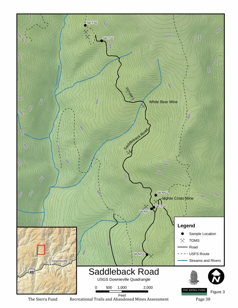
Ç
ÇÇÇ
Ç
Ç
ÇÇ
ÇÇ
ÇÇÇÇÇ
ÇÇ
Ç
Ç
Ç
ÇÇ
Ç
Ç
Ç Ç
ÇÇ
Ç Ç
ÇÇÇ
ÇÇ
Ç
Ç
ÇÇÇ
ÇÇ
Ç
ÇÇ
ÇÇÇÇÇ
Ç
Ç
ÇÇ
Ç
ÇÇ
ÇÇ
ÇÇ Ç
Ç
ÇÇ
ÇÇÇ
Ç
ÇÇ
ÇÇ
Ç
Ç
ÇÇ
Ç
ÇÇÇÇ
ÇÇ
Ç ÇÇ
Ç
Ç
Ç
ÇÇ
ÇÇ
Ç
ÇÇ
Ç
ÇÇ
Ç
ÇÇ
ÇÇÇ
ÇÇÇ
Ç
Ç
Ç
ÇÇ
ÇÇ
Ç
ÇÇ
Ç
!
!
!!
!
!SB-TS6
SB-TS5
SB-TS4SB-MS3
SB-MS2
SB-MS1
White Bear Mine
Monte Cristo Mine
5200
5400
5600
4800
5000
5800
4400
4600
4200
60006200
4000
4 200
6000
4400
5600
5600
4600
4000
5600
4600
5400
5400
5800
5800
5400
4800
4 40
0
5200
54005000
5800
5400
5800
48004800
4400
4800
5000
5200
5400
4400
4200
Good
years
Creek
05TH68-1
I0 1,000 2,000500
Feet
Saddleback Road^
£¤49
Downieville
USGS Downieville Quadrangle
Saddle
back Road
Legend! Sample LocationÇ TOMS
RoadUSFS RouteStreams and Rivers
Figure 3The Sierra Fund Recreational Trails and Abandoned Mines Assessment Page 38
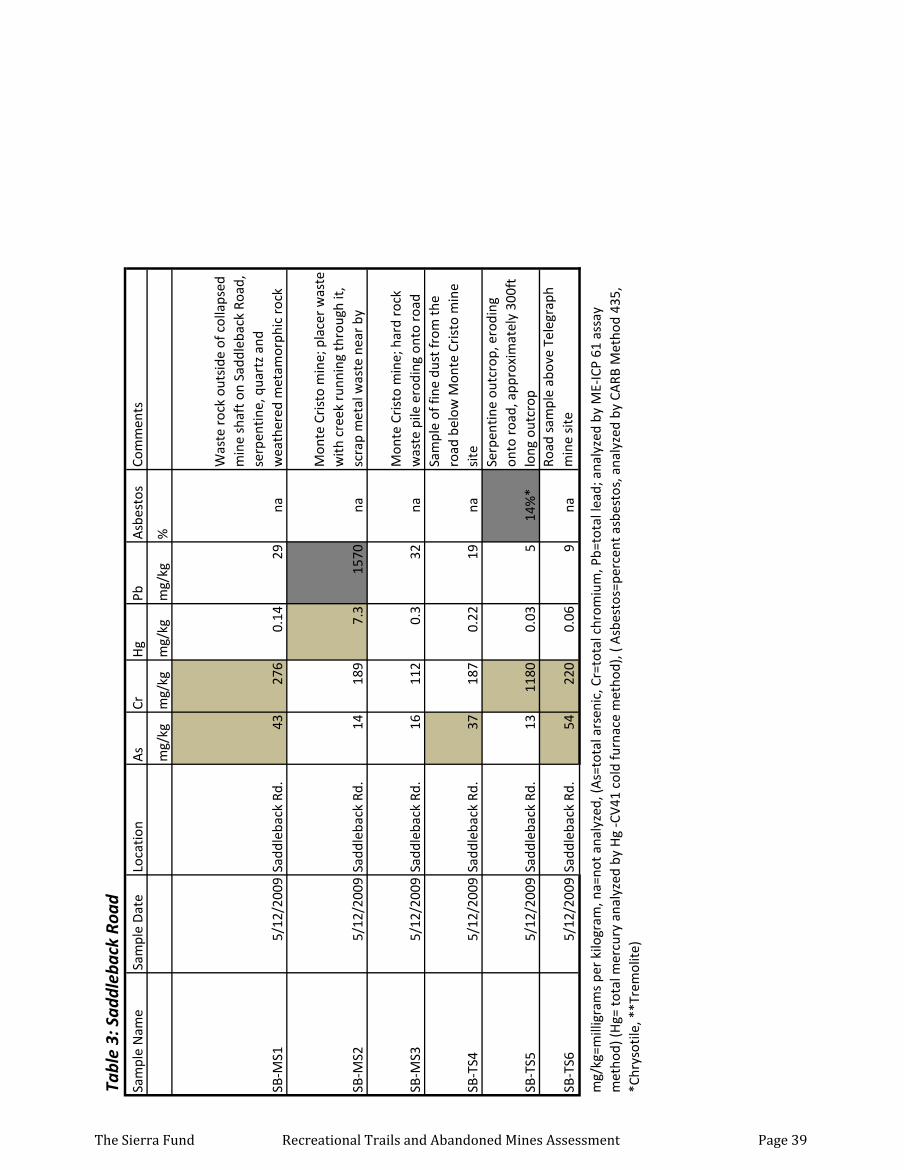
Tabl
e 3:
Sad
dleb
ack
Road
Sam
ple
Nam
eSa
mpl
e D
ate
Loca
tion
As
CrH
gPb
Asb
esto
sCo
mm
ents
mg/
kgm
g/kg
mg/
kgm
g/kg
%
SB-M
S15/
12/2
009
Sadd
leba
ck R
d.43
276
0.14
29na
Was
te r
ock
outs
ide
of c
olla
psed
m
ine
shaf
t on
Sadd
leba
ck R
oad,
se
rpen
tine,
qua
rtz
and
wea
ther
ed m
etam
orph
ic r
ock
SB-M
S25/
12/2
009
Sadd
leba
ck R
d.14
189
7.3
1570
na
Mon
te C
rist
o m
ine;
pla
cer
was
te
with
cre
ek r
unni
ng th
roug
h it,
sc
rap
met
al w
aste
nea
r by
SB-M
S35/
12/2
009
Sadd
leba
ck R
d.16
112
0.3
32na
Mon
te C
rist
o m
ine;
har
d ro
ck
was
te p
ile e
rodi
ng o
nto
road
SB-T
S45/
12/2
009
Sadd
leba
ck R
d.37
187
0.22
19na
Sam
ple
of fi
ne d
ust f
rom
the
road
bel
ow M
onte
Cri
sto
min
e si
te
SB-T
S55/
12/2
009
Sadd
leba
ck R
d.13
1180
0.03
514
%*
Serp
entin
e ou
tcro
p, e
rodi
ng
onto
roa
d, a
ppro
xim
atel
y 30
0ft
long
out
crop
SB-T
S65/
12/2
009
Sadd
leba
ck R
d.54
220
0.06
9na
Road
sam
ple
abov
e Te
legr
aph
min
e si
te
mg/
kg=m
illig
ram
s pe
r ki
logr
am, n
a=no
t ana
lyze
d, (A
s=to
tal a
rsen
ic, C
r=to
tal c
hrom
ium
, Pb=
tota
l lea
d; a
naly
zed
by M
E-IC
P 61
ass
ay
met
hod)
(Hg=
tota
l mer
cury
ana
lyze
d by
Hg
-CV4
1 co
ld fu
rnac
e m
etho
d), (
Asb
esto
s=pe
rcen
t asb
esto
s, a
naly
zed
by C
ARB
Met
hod
435,
*C
hrys
otile
, **T
rem
olite
)
The Sierra Fund Recreational Trails and Abandoned Mines Assessment Page 39
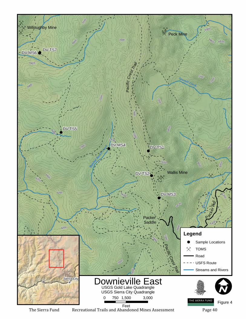
ÇÇÇ
Ç
Ç ÇÇ ÇÇ
Ç
Ç
Ç
Ç
ÇÇ
ÇÇÇÇ ÇÇÇ
Ç
ÇÇÇÇÇÇ
Ç
ÇÇÇÇ
Ç
Ç
Ç
Ç
Ç
ÇÇ
ÇÇ
Ç
Ç
Ç
Ç
Ç
ÇÇ
ÇÇÇÇÇÇ
ÇÇÇÇ
ÇÇ
ÇÇÇ
ÇÇÇ
Ç ÇÇÇ
ÇÇ Ç
ÇÇÇ
ÇÇÇ
Ç
Ç
ÇÇ Ç
ÇÇÇÇÇ
Ç
Ç
ÇÇÇ
Ç
Ç
Ç
ÇÇ
Ç
ÇÇÇ ÇÇ
Ç
ÇÇÇÇ
ÇÇÇ
Ç
ÇÇ
!
!
!
!
!
!!
Peck Mine
Wallis Mine
Willoughby Mine
DV-TS7DV-MS6
DV-TS5
DV-MS4
DV-MS3
DV-TS2
DV-TS1
6600
6800
7200
7000
7400
6400
6200
6200
7000
7200
6800
6200
7 400
6 4 00
7 000
6600
6600
6200
6 6 00
680 0
6800
6400
66006800
660 0
68 00
6800
7000
7000
7000
64 00
6800
7200
7000
7200
640 0
68
0064 00
6200
Packe
r Cree
k
Butche
r Ranc
h Cree
k
Sawmill Creek
I0 1,500 3,000750
Feet
Downieville East^
^£¤49Sierra City
USGS Gold Lake QuadrangleUSGS Sierra City Quadrangle
Legend! Sample LocationsÇ TOMS
RoadUSFS RouteStreams and Rivers
Figure 4
Packer Saddle
Pacif
ic Cr
est T
rail
Pacific Crest Trail
P acke
r Rd.
The Sierra Fund Recreational Trails and Abandoned Mines Assessment Page 40

Tabl
e 4:
Dow
niev
ille
East
Sam
ple
Nam
eSa
mpl
e D
ate
Loca
tion
As
CrPb
Asb
esto
sCo
mm
ents
mg/
kgm
g/kg
mg/
kg%
DV-
TS1
6/13
/200
9D
owni
evill
e11
2646
naPa
cific
Cre
st T
rail
DV-
TS2
6/13
/200
9D
owni
evill
e<5
146
naO
HV
road
100
yar
ds fr
om P
acifi
c Cr
est T
rail
DV-
MS3
6/13
/200
9D
owni
evill
e66
153
34na
Dep
ress
ion
on P
acifi
c Cr
est T
rail
DV-
MS4
6/13
/200
9D
owni
evill
e16
3626
naPl
acer
Min
e w
aste
alo
ng B
utch
er C
reek
DV-
TS5
6/13
/200
9D
owni
evill
e50
7226
naM
ine
was
te e
rodi
ng o
nto
road
DV-
MS6
6/13
/200
9D
owni
evill
e36
7396
3na
Har
d ro
ck m
ine
was
te b
elow
ope
n m
ine
shaf
t or
tunn
el n
ear
Paul
y Cr
eek
DV-
TS7
6/13
/200
9D
owni
evill
e30
4828
naD
irt r
oad
belo
w m
ine
was
te
BB-T
S16/
14/2
009
Big
Boul
der
Trai
l9
5814
naTr
ail w
ith p
ossi
ble
min
e w
aste
, bel
ow a
ssum
ed m
ine
loca
tion
BB-T
S26/
13/2
009
Big
Boul
der
Trai
l<5
66
naTr
ail c
ross
ing
min
e w
aste
~40
ft b
elow
por
tal
BB-T
S36/
13/2
009
Big
Boul
der
Trai
l<5
813
naSa
nd s
ilt, w
hite
san
d, tr
ail o
n te
rrac
e be
low
min
e po
rtal
mg/
kg=m
illig
ram
s pe
r ki
logr
am, n
a=no
t ana
lyze
d, (A
s=to
tal a
rsen
ic, C
r=to
tal c
hrom
ium
, Pb=
tota
l lea
d; a
naly
zed
by M
E-IC
P 61
ass
ay m
etho
d)
(Hg=
tota
l mer
cury
ana
lyze
d by
Hg
-CV4
1 co
ld fu
rnac
e m
etho
d), (
Asb
esto
s=pe
rcen
t asb
esto
s, a
naly
zed
by C
ARB
Met
hod
435,
*Ch
ryso
tile,
**
Trem
olite
)
The Sierra Fund Recreational Trails and Abandoned Mines Assessment Page 41
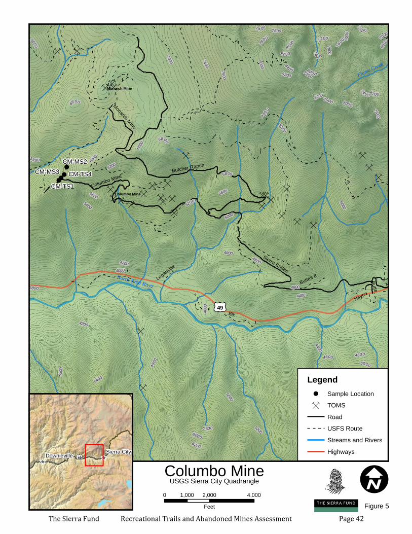
Ç
ÇÇÇÇ
Ç
Ç
ÇÇ
ÇÇÇÇÇÇ
ÇÇÇÇ
ÇÇ
ÇÇÇ
ÇÇÇ
Ç ÇÇÇ
ÇÇ Ç
ÇÇÇ
ÇÇÇ
Ç
Ç
ÇÇ ÇÇÇÇÇÇ
Ç
ÇÇÇ
Ç
ÇÇÇ
Ç
Ç ÇÇÇÇ
Ç
ÇÇÇÇ
ÇÇÇ
Ç
ÇÇ
Ç
!
!
!!
^
CM-TS4CM-MS3CM-MS2
CM-TS1Columbo Mine
Monarch Mine
State Highway 49
Main
Sierra Buttes
Butcher Ranch
Blk
Columbo Mine
Monarch MineButte
Buttes 8
Hayes
Old Hwy 49
B B
Loganville
Butte
6200
6000
4200
4400
5600
5400
4600
4800
6400
5200
6600
5000
4000
6800
7000
7 20
0
7400
76005800
78
00
3800
8200
8000 8400
7 200760 0
8200
7600
6800
6800
5800
7800
4800
6600
8 000
7600
7400
60 00
580
0
74 00
6400
8000
72 0 0
5 800
5600
5000
4000
6 000
5800
6200
7600
8 000
5 8 00
4400
8 200
6200
6200
4200
80 00
6400
5400
82 00
7000
5200
4600
5600
600 0
7 4 00
4800
4800
6600 76
0 0
6400
5200
5000
North Yuba River
Flume Creek
£¤49
I0 2,000 4,0001,000Feet
Columbo Mine^^£¤49
Sierra CityDownieville
USGS Sierra City Quadrangle
Legend! Sample LocationÇ TOMS
RoadUSFS RouteStreams and RiversHighways
Figure 5The Sierra Fund Recreational Trails and Abandoned Mines Assessment Page 42
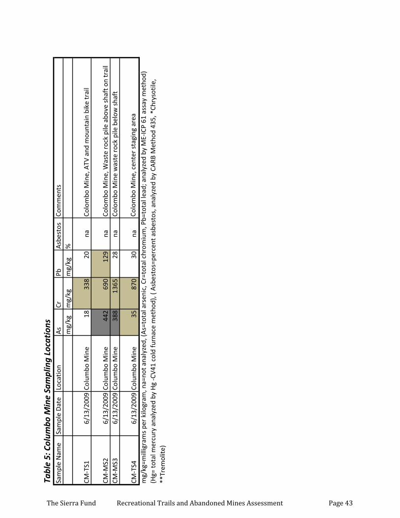
Tabl
e 5:
Col
umbo
Min
e Sa
mpl
ing
Loca
tion
sSa
mpl
e N
ame
Sam
ple
Dat
eLo
catio
nA
sCr
PbA
sbes
tos
Com
men
tsm
g/kg
mg/
kgm
g/kg
%
CM-T
S16/
13/2
009
Colu
mbo
Min
e18
338
20na
Colo
mbo
Min
e, A
TV a
nd m
ount
ain
bike
trai
l
CM-M
S26/
13/2
009
Colu
mbo
Min
e44
269
012
9na
Colo
mbo
Min
e, W
aste
roc
k pi
le a
bove
sha
ft o
n tr
ail
CM-M
S36/
13/2
009
Colu
mbo
Min
e38
813
6528
naCo
lom
bo M
ine
was
te r
ock
pile
bel
ow s
haft
CM-T
S46/
13/2
009
Colu
mbo
Min
e35
870
30na
Colo
mbo
Min
e, c
ente
r st
agin
g ar
ea
mg/
kg=m
illig
ram
s pe
r ki
logr
am, n
a=no
t ana
lyze
d, (A
s=to
tal a
rsen
ic, C
r=to
tal c
hrom
ium
, Pb=
tota
l lea
d; a
naly
zed
by M
E-IC
P 61
ass
ay m
etho
d)
(Hg=
tota
l mer
cury
ana
lyze
d by
Hg
-CV4
1 co
ld fu
rnac
e m
etho
d), (
Asb
esto
s=pe
rcen
t asb
esto
s, a
naly
zed
by C
ARB
Met
hod
435,
*Ch
ryso
tile,
**
Trem
olite
)
The Sierra Fund Recreational Trails and Abandoned Mines Assessment Page 43
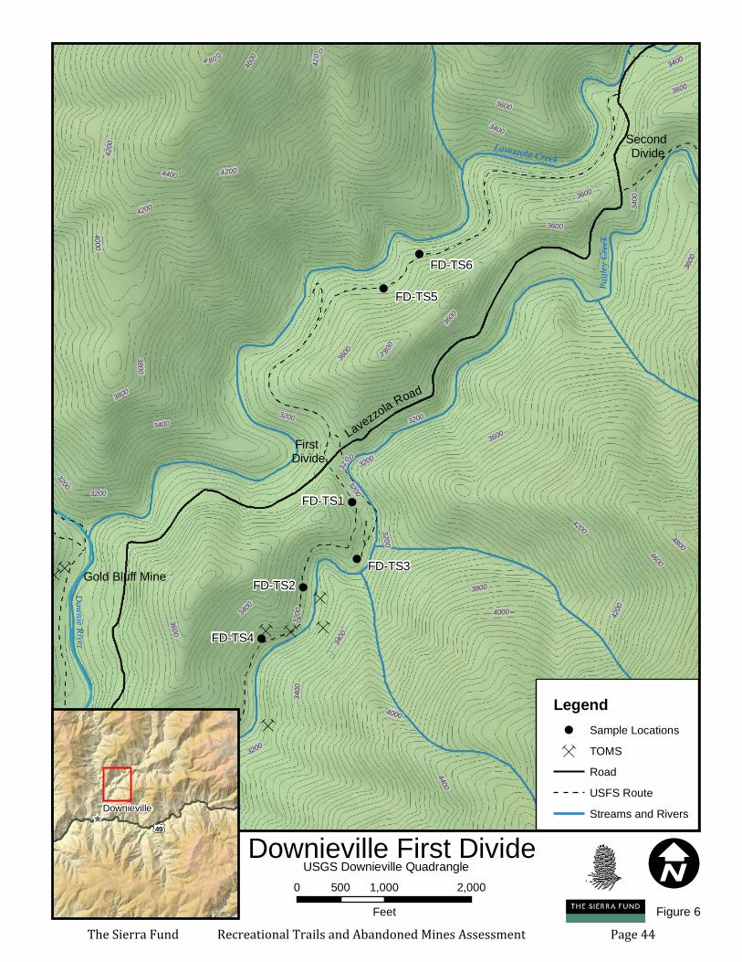
ÇÇÇ
ÇÇÇ
Ç
Ç
ÇÇÇ
ÇÇ
Ç
ÇÇ
Ç
Ç
ÇÇ
ÇÇ Ç
Ç
ÇÇ
ÇÇÇ
Ç
ÇÇ
ÇÇ
Ç
Ç
ÇÇ
Ç
ÇÇÇÇ
ÇÇ
Ç ÇÇ
Ç
Ç
Ç
ÇÇ
ÇÇ
Ç
ÇÇ
Ç
ÇÇ
Ç
ÇÇ
ÇÇÇ
ÇÇÇ
Ç
Ç
Ç
ÇÇ
ÇÇ
Ç
ÇÇ
Ç
Ç
Ç
!
!
!
!
!
!
FD-TS2
FD-TS1
First Divide
Second Divide
FD-TS6
FD-TS5
FD-TS4
FD-TS3Gold Bluff Mine
3200
3800
3600
3400
4400
4600
4200
3000
4000
4800
5000
5200
4200
3200
4 80 0
3200
4200
3200
3200
3 800
3600
3200
3800
4800
3600
4400
3200340
0
3400
3400
4200
3400
3800
4000
32
00
3600
3600
3600
3200
3400
4200
3200
36003400
3600
3600
4600
3200
4200
4000Pa
uley C
reek
Lavezzola Creek
Downie River
I0 1,000 2,000500Feet
Downieville First Divide^
£¤49
Downieville
USGS Downieville Quadrangle
Legend! Sample LocationsÇ TOMS
RoadUSFS RouteStreams and Rivers
Figure 6
Lavezzola Road
The Sierra Fund Recreational Trails and Abandoned Mines Assessment Page 44
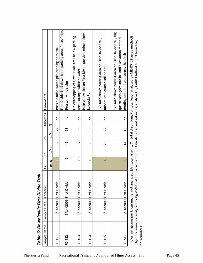
Tabl
e 6:
Dow
niev
ille
Firs
t Div
ide
Trai
lSa
mpl
e N
ame
Sam
ple
Dat
eLo
catio
nA
sCr
PbA
sbes
tos
Com
men
ts
mg/
kgm
g/kg
mg/
kg%
FD-T
S16/
14/2
009
Firs
t Div
ide
3032
24na
Poss
ible
min
e w
aste
pile
ero
ding
ont
o tr
ail
FD-T
S26/
14/2
009
Firs
t Div
ide
945
13na
Firs
t Div
ide
Trai
l dow
n fr
om p
arki
ng a
rea,
Pri
ce, P
rice
, Pr
esto
n M
ine
clai
m
FD-T
S36/
14/2
009
Firs
t Div
ide
107
3na
On
outc
ropp
ing
of F
irst
Div
ide
Trai
l bel
ow p
arki
ng
area
, str
ange
whi
te p
owde
r
FD-T
S46/
14/2
009
Firs
t Div
ide
1566
52na
Hol
e be
low
site
on
Firs
t Div
ide
poss
ible
min
e be
low
La
vazo
la R
d.
FD-T
S56/
14/2
009
Firs
t Div
ide
4228
24na
1/2
mile
abo
ve p
arki
ng a
rea
on F
irst
Div
ide
Trai
l, m
iner
aliz
ed q
uart
z so
il on
trai
l
FD-M
S66/
14/2
009
Firs
t Div
ide
6941
40na
1/2
mile
abo
ve p
arki
ng a
rea
on F
irst
Div
ide
Trai
l, bi
g qu
artz
vei
n go
es in
to h
ill a
nd e
xcav
atio
n m
ater
ial
erod
ing
onto
trai
l and
acr
oss
the
ditc
h
mg/
kg=m
illig
ram
s pe
r ki
logr
am, n
a=no
t ana
lyze
d, (A
s=to
tal a
rsen
ic, C
r=to
tal c
hrom
ium
, Pb=
tota
l lea
d; a
naly
zed
by M
E-IC
P 61
ass
ay m
etho
d)
(Hg=
tota
l mer
cury
ana
lyze
d by
Hg
-CV4
1 co
ld fu
rnac
e m
etho
d), (
Asb
esto
s=pe
rcen
t asb
esto
s, a
naly
zed
by C
ARB
Met
hod
435,
*Ch
ryso
tile,
**
Trem
olite
)
The Sierra Fund Recreational Trails and Abandoned Mines Assessment Page 45
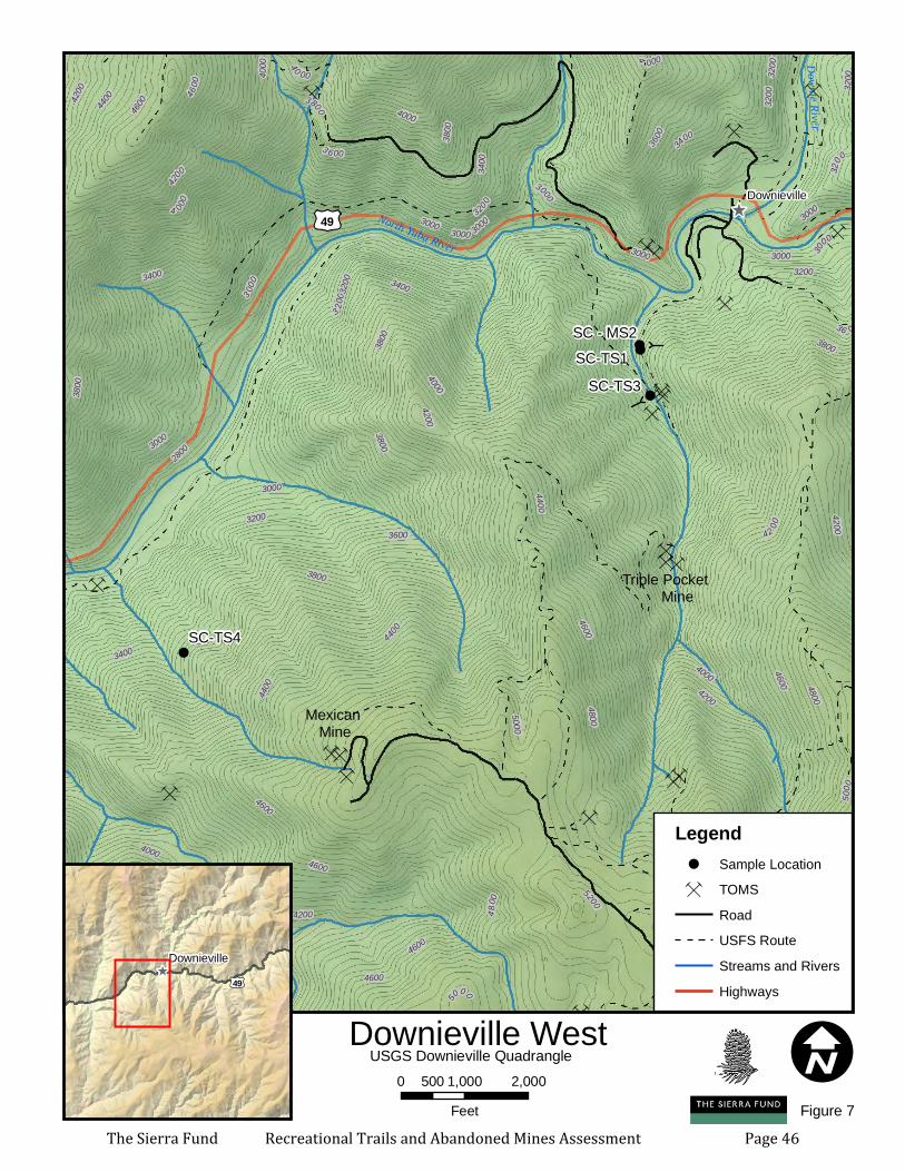
Ç
ÇÇ
Ç
ÇÇ
ÇÇÇÇ
ÇÇÇÇ
ÇÇ
ÇÇÇ
Ç
ÇÇÇ
Ç
ÇÇ
ÇÇ
Ç
Ç
ÇÇ
Ç
ÇÇÇÇ
ÇÇÇ ÇÇ
Ç
Ç
Ç
ÇÇÇÇ
Ç
ÇÇ
Ç
ÇÇ
Ç
ÇÇ
ÇÇÇ
ÇÇÇ
ÇÇ
Ç
Ç ÇÇÇ
ÇÇÇ
ÇÇ
ÇÇ
ÇÇ Ç
Ç
ÇÇÇ ÇÇÇ
ÇÇÇÇÇÇ
ÇÇÇÇ
ÇÇÇÇÇÇ
Ç
Ç
ÇÇÇÇ Ç
!!
!
!
^
Triple Pocket Mine Text
Text
SC-TS4
SC-TS3
SC - MS2SC-TS1
3400
3000
3600
4000
3200
4200
2800
4800
3800
4400
5000
4600
5200
5400
3400
5200
3000
3800
5000
3200
3200
4400
3800
4200
4600
4000
3800
4000
4800
3000
3000
3800
42 00
3800
5000
3000
4600
3000
5400
3000
4600
4600
4800
4200
3000
4600
4 000
36 00
4600
3 200
3200
3400
4600
3200
3000
3400
3 000
4000
3400
4200
4400
3200
4200
4600
3 6 00
3600
4 000
3200
4200
5000
4000
40 00
4200
32003800
30
00
4400
4600
North Yuba River
Rock Creek
Downie River
£¤49Downieville
I0 1,000 2,000500Feet
Downieville West^
£¤49
Downieville
USGS Downieville Quadrangle
Legend! Sample LocationÇ TOMS
RoadUSFS RouteStreams and RiversHighways
Figure 7
Mexican Mine
The Sierra Fund Recreational Trails and Abandoned Mines Assessment Page 46

Tabl
e 7:
Dow
niev
ille
Wes
tSa
mpl
e D
ate
Loca
tion
Sam
ple
Nam
eA
sCr
PbA
sbes
tos
Com
men
tsm
g/kg
mg/
kgm
g/kg
%
6/14
/200
9Sl
ug C
anyo
nS
C-T
S1
439
188
38na
Tra
il 50
feet
nor
th o
f sm
all c
reek
(m
ine
disc
harg
e)
whi
ch c
ross
es th
e tr
ail a
nd e
nter
s S
lug
Can
yon.
0-0
.5
inch
es s
crap
ed o
ff tr
ail =
min
e w
aste
- gr
ey s
ilty
sand
an
d gr
avel
6/14
/200
9Sl
ug C
anyo
nS
C-M
S2
40
016
524
na
Was
te r
ock
on s
lope
just
off
trai
l edg
e do
wn
slop
e of
tr
ail.
Fre
sher
min
e w
aste
– g
rey
sand
w q
uart
z an
d m
iner
aliz
ed r
ock
frag
men
ts.
0-4”
dep
t h
6/14
/200
9Sl
ug C
anyo
nS
C-T
S3
118
983
18na
Tra
il ne
xt to
the
seco
nd tu
nnel
sho
wn
on S
lug
Can
yon
Tra
il so
il 0-
1” im
med
iate
ly d
own
slop
e of
sec
ond
tunn
el s
eale
d w
ith fo
am a
nd b
at g
rate
, 100
feet
pas
t ne
w w
ood
brid
ge
6/14
/200
9Sl
ug C
anyo
nS
C-T
S4
1691
33na
Tra
il do
wn
slop
e of
a q
uart
z pr
ospe
ct a
bove
the
N.
Yub
a. G
rey
brow
n si
lty s
and
with
ang
ular
gra
vel.
0-
0.5”
scr
aped
off
trai
l sur
face
mg/
kg=m
illig
ram
s pe
r ki
logr
am, n
a=no
t ana
lyze
d, (A
s=to
tal a
rsen
ic, C
r=to
tal c
hrom
ium
, Pb=
tota
l lea
d; a
naly
zed
by M
E-IC
P 61
ass
ay m
etho
d)
(Hg=
tota
l mer
cury
ana
lyze
d by
Hg
-CV4
1 co
ld fu
rnac
e m
etho
d), (
Asb
esto
s=pe
rcen
t asb
esto
s, a
naly
zed
by C
ARB
Met
hod
435,
*Ch
ryso
tile,
**
Trem
olite
)
The Sierra Fund Recreational Trails and Abandoned Mines Assessment Page 47
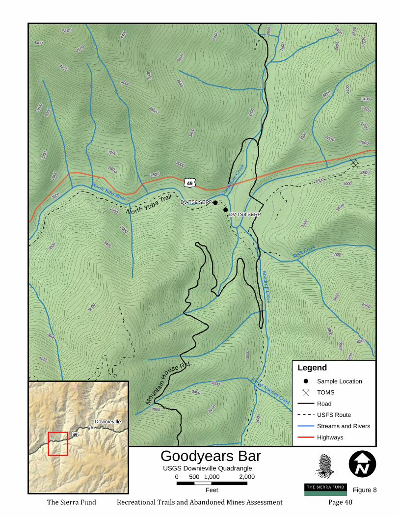
Ç
ÇÇ
ÇÇ
Ç
Ç
ÇÇ
ÇÇÇÇ
ÇÇÇÇ
ÇÇ
ÇÇÇ
Ç
Ç ÇÇ
Ç
Ç
ÇÇ
ÇÇ
Ç
Ç
ÇÇ
Ç
ÇÇÇÇ
ÇÇ
Ç
ÇÇÇÇ
Ç
ÇÇ
Ç
Ç
Ç
ÇÇ
ÇÇÇ
ÇÇÇ
ÇÇ
Ç
ÇÇÇÇ
ÇÇÇ
Ç
ÇÇÇ ÇÇÇ
ÇÇÇÇÇÇ
ÇÇÇÇ
ÇÇÇÇÇÇ
Ç
Ç Ç
ÇÇ
Ç
Ç
ÇÇ
!
!
Mo
untain
House R d.
DV-TS9 SERP
DV-TS8 SERP
3000
3600
3800
4000
2600
4200
2800
4400
4 600
4 8 0 0
4000
3000
4000
3800
3400
3000
3600
3800
3200
4200
2800
46
00
4000
40 00
2800
3400
3600
300 0
2800
3000
3200
3600
4000
4400
34 00
3400
3200
4600
2800
3600
4200
2800
4400
3400
3000
3400
3000
4400
3000
3200
3400
4200
3400
3400
2800
3000
3600
28 00
3000
3800
2800
3400
3000
3800
3000
420034
00
2800
4400
North Yuba River
Woodruff Creek
Goodyea
rs Cree
k
Rock Creek
Young America Creek
£¤49
I0 1,000 2,000500Feet
Goodyears Bar^
£¤49
Downieville
USGS Downieville Quadrangle
Legend! Sample LocationÇ TOMS
RoadUSFS RouteStreams and RiversHighways
Figure 8
N o rth Yuba Trail
The Sierra Fund Recreational Trails and Abandoned Mines Assessment Page 48
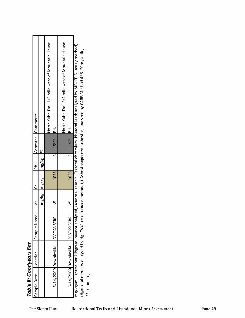
Tabl
e 8:
Goo
dyea
rs B
arSa
mpl
e D
ate
Loca
tion
Sam
ple
Nam
eA
sCr
PbA
sbes
tos
Com
men
tsm
g/kg
mg/
kgm
g/kg
%
6/14
/200
9D
owni
evill
eD
V-TS
8 SE
RP<5
1035
815
%*
Nor
th Y
uba
Trai
l 1/2
mile
wes
t of M
ount
ain
Hou
se
Rd.
6/14
/200
9D
owni
evill
eD
V-TS
9 SE
RP<5
1835
311
%*
Nor
th Y
uba
Trai
l 3/4
mile
wes
t of M
ount
ain
Hou
se
Rd.
mg/
kg=m
illig
ram
s pe
r ki
logr
am, n
a=no
t ana
lyze
d, (A
s=to
tal a
rsen
ic, C
r=to
tal c
hrom
ium
, Pb=
tota
l lea
d; a
naly
zed
by M
E-IC
P 61
ass
ay m
etho
d)
(Hg=
tota
l mer
cury
ana
lyze
d by
Hg
-CV4
1 co
ld fu
rnac
e m
etho
d), (
Asb
esto
s=pe
rcen
t asb
esto
s, a
naly
zed
by C
ARB
Met
hod
435,
*Ch
ryso
tile,
**
Trem
olite
)
The Sierra Fund Recreational Trails and Abandoned Mines Assessment Page 49
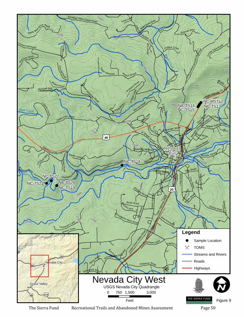
Ç
ÇÇÇÇÇ
ÇÇ
ÇÇÇÇ
Ç
ÇÇ ÇÇÇÇÇÇÇÇÇÇÇÇÇÇ
Ç ÇÇÇÇÇÇÇÇÇ Ç
Ç
Ç
Ç
ÇÇÇ Ç
Ç
Ç Ç
ÇÇ
Ç
Ç
Ç
Ç Ç
Ç
ÇÇ
ÇÇÇ
Ç Ç
ÇÇÇ Ç
Ç
Ç
ÇÇÇ
ÇÇ
ÇÇÇÇ
Ç
ÇÇÇ
Ç
Ç
Ç
Ç
Ç
Ç
ÇÇÇ
ÇÇÇÇÇÇ
ÇÇÇÇÇÇÇÇÇÇÇÇÇÇÇÇÇÇÇÇ
Ç
Ç
ÇÇÇ
!!!
!!!!
!!!!
!
!!!
!
NC-MST12
Newtown DitchNC-TS22
NC-TS21 NC-TS20NC-TS19
NC-TS18
NC-TS15NC-TS14 NC-TS13
Deer Creek
Gold Run
Brush Creek
Little Deer Creek
Rush Creek
2700
2500
2900
2300
3100
3300
2 900
2 7 00
27 00
2 700
2500
2700
2700
2700
270 0
2900
Ridge Road
Cement Hill Road
State
Highw
ay 49
/20
Champio n Road
Indian Flat Road
Zion S
treet
C oy ote S treet
Nevad
a S
treet
A irpo rt Ro ad
Old Downieville H ighway
Gold Flat Road
American Hill RoadSe
arls A
venu
e
N Bloo
mfield
-gran
itevill
e Roa
d
Via Vista
Lake Vera-purdon RoadState Highway 20
Boulder Street
Clay Street
Excelsior Ditch Camp Road
Pittsburg Road
Wet Hill Road
Gracie Road
Nimrod Street
Rock Creek Road
Long
Stre
et
Nevada City H ighway
Hollow
Way
Main StreetSpring Street
Marjon Drive
S Pine
Stree
t
Sacramento St
reet
W Broad Street
Echo Ridge Drive
Hobnob Way
Grove Street
Brock Road
Daisy Blue Mine Road
Uren Street
N Pine Street
Country Circle
Lot h lorien Lane
Ho over Lane
Tower Hill Road
Go
chine Drive
Alderwood Way
Pinewoods Road
Granholm Lane
Fox Hill Road
Willow Valley Road
Ragon RoadW Airport R
oad
B Street
Til
l icum Way
Nile Street
Greenwood Circle
Bost Avenue
Osdick Court
Woodwardia PlaceLower G
rass V
alley R
oad
Cedar View Road
Providence Mine Road
Reward Street
Merryhill Way
Glenwood Road
Ab
bey Cour
t
Merrill Court
Orch ard Street
Jordan Street
Bourbon Hill Road
Northview Drive
Wyoming Road
Stable Lane
Nih ell Street
Hawke Lane
W Piper Road
Martin Stree
t
Charlene Lane
Foster Driveway Road
High Street
Alexander Street
Cedro Road
Atkins Road
Via Colina Drive
Liberty Circle
Golde
n Oak
s Cou
rt
Galen
a Way
Timm Lane
Helling W
ayAs
tral T
rail
Ridge Estates Road
Calvary Street
E Pipe
r Lan
e
Melanie Court
Palisa
de D
rive
Queen Lil Place
E Elliot Way
Shady Lane
Valley Street
£¤49
£¤20
I0 1,500 3,000750Feet
Nevada City West^
^
£¤20
£¤174
£¤49
£¤49
Nevada City
Grass Valley USGS Nevada City Quadrangle
Legend! Sample LocationÇ TOMS
Streams and RiversRoadsHighways
Figure 9
Nevada City
The Sierra Fund Recreational Trails and Abandoned Mines Assessment Page 50

Tabl
e 9:
Nev
ada
City
Wes
tSa
mpl
e N
ame
Sam
ple
Dat
eLo
catio
nA
sCr
PbA
sbes
tos
Com
men
tsm
g/kg
mg/
kgm
g/kg
%
NC-
TS18
8/3/
2005
Trib
ute
Trai
l<5
2224
na
Trib
ute
trai
l sec
tion
Cham
pion
Rd.
to N
ID, 5
0 ya
rds
uphi
ll fr
om N
ID r
oad
befo
re it
ent
ers
woo
ds, s
ampl
ed d
usty
spo
t on
new
ly
cons
truc
ted
trai
l
NC-
TS19
8/3/
2005
Trib
ute
Trai
l6
1430
naA
t min
e w
aste
pile
cut
by
new
trai
l, gr
aniti
c fr
actu
red
rock
in s
ilty
sand
NC-
TS20
8/3/
2005
New
tow
n D
itch
521
2012
15%
**
On
New
tow
n di
tch
trai
l acr
oss
from
se
rpen
tine
outc
rops
cut
by
ditc
h co
nstr
uctio
n,
assu
med
ser
pent
ine
on tr
ail
NC-
TS21
8/3/
2005
New
tow
n D
itch
2622
5041
naN
ewto
wn
ditc
h tr
ail a
cros
s fr
om u
ltram
afic
ro
ck e
xcav
atio
n sp
oils
dus
ty a
rea
of tr
ail
NC-
TS22
8/3/
2005
New
tow
n D
itch
1923
7031
10%
**
Trai
l on
New
tow
n di
tch
acro
ss fr
om
serp
entin
e ro
ck o
utcr
op, s
erpe
ntin
e ro
ck o
n tr
ail s
urfa
ce
NC-
MST
127/
17/2
009
Man
zani
ta D
iggi
ngs
819
23na
Man
zani
ta D
iggi
ngs
alon
g tr
ail n
ear
Hig
hway
20
, was
te w
as to
the
righ
t of t
he tr
ail
NC-
TS13
7/17
/200
9M
anza
nita
Dig
ging
s42
5931
naM
anza
nita
Dig
ging
s in
cut
thro
ugh
mou
nd o
f fin
e gr
aine
d pl
acer
spo
ils
NC-
TS14
7/17
/200
9M
anza
nita
Dig
ging
s<5
8426
naM
anza
nita
Dig
ging
s st
eep
hill
trai
l goe
s do
wn
thro
ugh
mou
nd o
f pla
cer
min
e w
aste
NC-
TS15
7/17
/200
9M
anza
nita
Dig
ging
s49
8457
naM
anza
nita
Dig
ging
s sa
mpl
es in
low
er b
umps
an
d tu
rns
NC-
TS16
8/3/
2005
Roun
d M
ount
ain
759
18na
150f
t abo
ve R
ock
Cree
k Ro
ad o
n flu
me
trai
l, at
sm
all m
ound
bel
ow d
epre
ssio
n ju
st a
bove
tr
ail
NC-
TS17
8/3/
2005
Roun
d M
ount
ain
672
17na
200
yard
s pa
st N
C-16
goi
ng e
ast o
n tr
ail a
t 3rd
la
rges
t mou
nd, ~
10 c
ubic
yar
ds m
ound
just
be
low
trai
l
mg/
kg=m
illig
ram
s pe
r ki
logr
am, n
a=no
t ana
lyze
d, (A
s=to
tal a
rsen
ic, C
r=to
tal c
hrom
ium
, Pb=
tota
l lea
d; a
naly
zed
by M
E-IC
P 61
ass
ay m
etho
d)
(Hg=
tota
l mer
cury
ana
lyze
d by
Hg
-CV4
1 co
ld fu
rnac
e m
etho
d), (
Asb
esto
s=pe
rcen
t asb
esto
s, a
naly
zed
by C
ARB
Met
hod
435,
*Ch
ryso
tile,
**
Trem
olite
)
The Sierra Fund Recreational Trails and Abandoned Mines Assessment Page 51
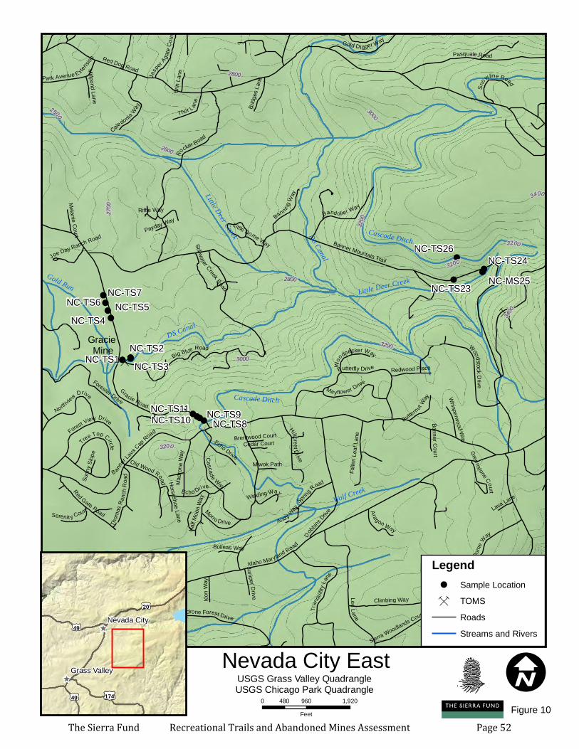
Ç
ÇÇÇÇÇ
ÇÇ
ÇÇÇÇ
Ç
Ç
Ç
ÇÇÇÇÇ
Ç
ÇÇ ÇÇÇÇÇÇÇÇÇÇ
ÇÇÇÇÇ ÇÇÇÇÇÇÇÇÇ Ç
ÇÇÇ
Ç
Ç
Ç Ç
ÇÇ
Ç
Ç
ÇÇ
Ç
Ç
Ç
ÇÇ
Ç
ÇÇ
Ç
Ç
Ç
Ç
ÇÇ
Ç
ÇÇ
ÇÇÇ
Ç
Ç
Ç
Ç
ÇÇÇ
ÇÇÇÇÇÇ
ÇÇ ÇÇÇÇÇÇÇÇ
ÇÇÇÇÇÇ ÇÇÇÇ
Ç
ÇÇÇ
!!!
!!!!
!!!!
!
!!
!
Gracie Mine
NC-TS9NC-TS8
NC-TS7NC-TS6 NC-TS5NC-TS4
NC-TS3NC-TS2
NC-TS1
NC-TS26
NC-MS25NC-TS24
NC-TS23
NC-TS11NC-TS10
Wolf Creek
DS Canal
Cascade Ditch
Gold Run
Little Deer Creek Cascade Ditch
DS Canal
Little Deer Creek
32003000
2800
3400
2700
2600
2500
3200
3400
3000
3200
3200
3000
3000
3200
3200
3000
2800
Red Dog Road
Idaho Maryland Road
Banner L
ava Cap
Road
Banner Mountain Trail
Gracie Road
Rocker Road
Lee Lane
Big Blue Road
Lava Cap Mine Road
Pasquale Road
Do
bbins
Drive
Lava Dom
e W
ay
Madrone Forest Drive
Mayflower Drive
Climbing Way
Bandolier Way
Hillcre st Drive
Woodst oc k D riv e
Red Gate Road
Tran
quilit
y Lane
Butterfly DriveCascade Way
Forest View Drive
Madro
na W
ay
Gold Digger Way
Old Wood Road
Falle
n Lea
f Lan
e
Sprin
g R
oad
Thor L ane
Caledonia Way
Banning W
ay
Sidehill Circle
Northview Drive
Echo Drive
Aragon WayHalf M
oon W
ay
Forester Drive
Morro Drive
Icon W
ay
Bridg
es La
ne
Thom
as Ra
nch R
o ad
Jasper A
gate
Court
Redwood Place
Park Avenue Extensi
onTree Top Circle
Butternut Way
Sierra Woodlands Court
Juniper Drive
Erin
Lane
Sereni t y CourtAnd y W
ay
Stillwa ter Creek Road
Woo
dpecker Way
Whisperwood Way
Banner Court
Melanie CourtLava Lane
Bolinas Way
Miwok Path
Winding WayMillpond Lane
Snowline Road
Little Dome Way
Cedar Court
Joe Day Ranch Road
Riffle Way
Greenstone CourtSu
nny S
lope
Silk Tassle Circle
Horseshoe Lane
Brentwood Court
Payday Way
Echo Drive
I0 960 1,920480
Feet
Nevada City East^
^
£¤20
£¤174
£¤49
£¤49
Nevada City
Grass Valley USGS Grass Valley QuadrangleUSGS Chicago Park Quadrangle
Legend! Sample LocationÇ TOMS
RoadsStreams and Rivers
Figure 10The Sierra Fund Recreational Trails and Abandoned Mines Assessment Page 52
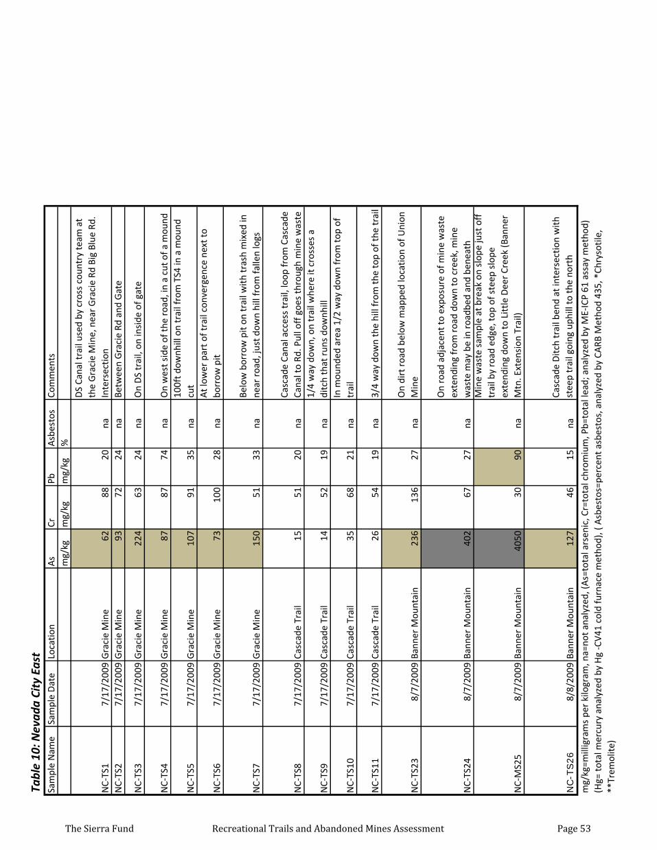
Tabl
e 10
: Nev
ada
City
Eas
t Sa
mpl
e N
ame
Sam
ple
Dat
eLo
catio
nA
sCr
PbA
sbes
tos
Com
men
tsm
g/kg
mg/
kgm
g/kg
%
NC-
TS1
7/17
/200
9G
raci
e M
ine
6288
20na
DS
Cana
l tra
il us
ed b
y cr
oss
coun
try
team
at
the
Gra
cie
Min
e, n
ear
Gra
cie
Rd B
ig B
lue
Rd.
Inte
rsec
tion
NC-
TS2
7/17
/200
9G
raci
e M
ine
9372
24na
Betw
een
Gra
cie
Rd a
nd G
ate
NC-
TS3
7/17
/200
9G
raci
e M
ine
224
6324
naO
n D
S tr
ail,
on in
side
of g
ate
NC-
TS4
7/17
/200
9G
raci
e M
ine
8787
74na
On
wes
t sid
e of
the
road
, in
a cu
t of a
mou
nd
NC-
TS5
7/17
/200
9G
raci
e M
ine
107
9135
na10
0ft d
ownh
ill o
n tr
ail f
rom
TS4
in a
mou
nd
cut
NC-
TS6
7/17
/200
9G
raci
e M
ine
7310
028
naA
t low
er p
art o
f tra
il co
nver
genc
e ne
xt to
bo
rrow
pit
NC-
TS7
7/17
/200
9G
raci
e M
ine
150
5133
naBe
low
bor
row
pit
on tr
ail w
ith tr
ash
mix
ed in
ne
ar r
oad,
just
dow
n hi
ll fr
om fa
llen
logs
NC-
TS8
7/17
/200
9Ca
scad
e Tr
ail
1551
20na
Casc
ade
Cana
l acc
ess
trai
l, lo
op fr
om C
asca
de
Cana
l to
Rd. P
ull o
ff g
oes
thro
ugh
min
e w
aste
NC-
TS9
7/17
/200
9Ca
scad
e Tr
ail
1452
19na
1/4
way
dow
n, o
n tr
ail w
here
it c
ross
es a
di
tch
that
run
s do
wnh
ill
NC-
TS10
7/17
/200
9Ca
scad
e Tr
ail
3568
21na
In m
ound
ed a
rea
1/2
way
dow
n fr
om to
p of
tr
ail
NC-
TS11
7/17
/200
9Ca
scad
e Tr
ail
2654
19na
3/4
way
dow
n th
e hi
ll fr
om th
e to
p of
the
trai
l
NC-
TS23
8/7/
2009
Bann
er M
ount
ain
236
136
27na
On
dirt
roa
d be
low
map
ped
loca
tion
of U
nion
M
ine
NC-
TS24
8/7/
2009
Bann
er M
ount
ain
402
6727
na
On
road
adj
acen
t to
expo
sure
of m
ine
was
te
exte
ndin
g fr
om r
oad
dow
n to
cre
ek, m
ine
was
te m
ay b
e in
roa
dbed
and
ben
eath
NC-
MS2
58/
7/20
09Ba
nner
Mou
ntai
n40
5030
90na
Min
e w
aste
sam
ple
at b
reak
on
slop
e ju
st o
ff
trai
l by
road
edg
e, to
p of
ste
ep s
lope
ex
tend
ing
dow
n to
Litt
le D
eer
Cree
k (B
anne
r M
tn. E
xten
sion
Tra
il)
NC-T
S26
8/8/
2009
Bann
er M
ount
ain
127
4615
naCa
scad
e D
itch
trai
l ben
d at
inte
rsec
tion
with
st
eep
trai
l goi
ng u
phill
to th
e no
rth
mg/
kg=m
illig
ram
s pe
r ki
logr
am, n
a=no
t ana
lyze
d, (A
s=to
tal a
rsen
ic, C
r=to
tal c
hrom
ium
, Pb=
tota
l lea
d; a
naly
zed
by M
E-IC
P 61
ass
ay m
etho
d)
(Hg=
tota
l mer
cury
ana
lyze
d by
Hg
-CV4
1 co
ld fu
rnac
e m
etho
d), (
Asb
esto
s=pe
rcen
t asb
esto
s, a
naly
zed
by C
ARB
Met
hod
435,
*Ch
ryso
tile,
**
Trem
olite
)
The Sierra Fund Recreational Trails and Abandoned Mines Assessment Page 53
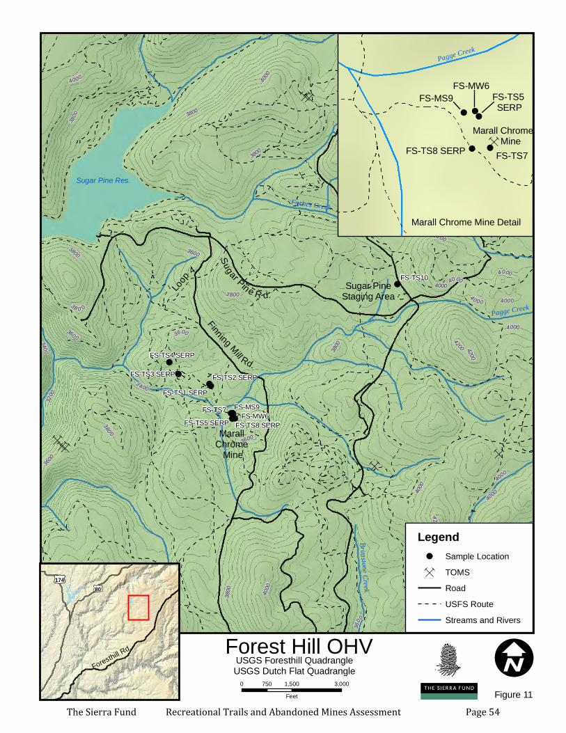
ÇÇ Ç
ÇÇ
ÇÇÇÇ
Ç
Ç Ç
Ç
ÇÇÇÇÇ
Ç
ÇÇ Ç
Ç
ÇÇÇÇ
Ç
ÇÇÇÇ
Ç
ÇÇÇÇÇÇÇ
ÇÇÇÇ
Ç
ÇÇ
Ç
ÇÇ ÇÇÇÇÇ
Ç
ÇÇÇ Ç
ÇÇÇÇÇÇ
ÇÇÇÇÇ
Ç
Ç ÇÇÇÇÇ
ÇÇ
ÇÇ
ÇÇÇÇÇ
Ç
ÇÇÇ
Ç
Ç
ÇÇÇ
Ç
ÇÇÇÇÇÇÇÇÇÇ
ÇÇÇ
Ç
ÇÇ
!!
!
!
!!!!!
!Sugar PineStaging Area
Finning Mill Rd.Sugar Pin e R d.Loo
p 4
FS-MS9FS-TS7 FS-MW6
FS-TS10
FS-TS8 SERPFS-TS5 SERP
FS-TS4 SERP
FS-TS3 SERP FS-TS2 SERPFS-TS1 SERP
3800 4000
3600
3 400
420032
00
400 038 0 0
3800
3800
42 00
3800
3600
360 0
4000
3400
4000
4000
3800
3600
4000
4000
4200
4000
4000
4000
4000
4200
4000
42 00
4000
3800
40 00
380 0
3 800
4000
4200
40
00
4000
4 000
4000
3600
3800
3600
4200
Pagge Creek
Forbes CreekBrimstone Creek Mountain
Chief Creek
Sugar Pine Res.
I0 1,500 3,000750
Feet
Forest Hill OHV
£¤80£¤174
Foresthill Rd.USGS Foresthill QuadrangleUSGS Dutch Flat Quadrangle
Legend! Sample LocationÇ TOMS
RoadUSFS RouteStreams and Rivers
Figure 11
Marall Chrome
Mine
!
!
!!
!!
!
Ç Ç
Ç
Ç
Ç Ç
Ç
Ç
ÇÇÇ
Ç
Ç
ÇÇ
Ç
Ç
Ç
Ç
ÇÇÇ Ç
Ç
ÇÇÇ
Ç
Ç
Ç
Ç
Ç
Ç
Ç
Ç
ÇÇ
Marall Chrome Mine
FS-MS9
FS-TS7
FS-MW6
FS-TS8 SERP
FS-TS5 SERP
Pagge Creek
Marall Chrome Mine Detail
The Sierra Fund Recreational Trails and Abandoned Mines Assessment Page 54
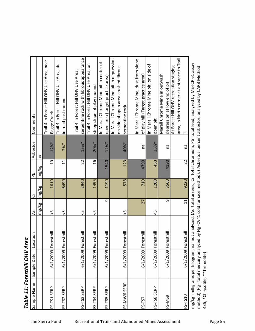
Tabl
e 11
: For
esth
ill O
HV
Are
aSa
mpl
e N
ame
Sam
ple
Dat
eLo
catio
nA
sCr
PbA
sbes
tos
Com
men
tsm
g/kg
mg/
kgm
g/kg
%
FS-T
S1 S
ERP
6/1/
2009
Fore
sthi
ll<5
1610
1912
%*
Trai
l 4 in
For
est H
ill O
HV
Use
Are
a, n
ear
Pagg
e Cr
eek
FS-T
S2 S
ERP
6/1/
2009
Fore
sthi
ll<5
6490
112%
*Tr
ail 4
in F
ores
t Hill
OH
V U
se A
rea,
dus
t in
roa
d pa
st m
ound
FS-T
S3 S
ERP
6/1/
2009
Fore
sthi
ll<5
2940
2215
%*
Trai
l 4 in
For
est H
ill O
HV
Use
Are
a,
serp
entin
e ro
ck w
ith fi
brou
s ap
pear
ance
FS-T
S4 S
ERP
6/1/
2009
Fore
sthi
ll<5
1495
1620
%*
Trai
l 4 in
For
est H
ill O
HV
Use
Are
a, o
n st
eep
slop
e of
pla
y m
ound
FS-T
S5 S
ERP
6/1/
2009
Fore
sthi
ll9
1190
1540
12%
*In
Mar
all C
hrom
e M
ine
pit i
n ce
nter
of
open
are
a (t
arge
t pra
ctic
e ar
ea)
FS-M
W6
SERP
6/1/
2009
Fore
sthi
ll<5
578
123
40%
*
In M
aral
l Chr
ome
Min
e pi
t in
depr
essi
on
on s
ide
of o
pen
area
cru
shed
fibr
ous
serp
entin
e ro
ck
FS-T
S76/
1/20
09Fo
rest
hill
2771
047
90na
In M
aral
l Chr
ome
Min
e, d
ust f
rom
slo
pe
of p
lay
hill
(Tar
get p
ract
ice
area
)
FS-T
S8 S
ERP
6/1/
2009
Fore
sthi
ll<5
1200
453
15%
*In
Mar
all C
hrom
e M
ine
pit,
on
side
of
open
pit
FS-M
S96/
1/20
09Fo
rest
hill
935
6041
90na
Mar
all C
hrom
e M
ine
in o
utw
ash
depr
essi
on a
t low
end
of p
it
FS-T
S10
6/1/
2009
Fore
sthi
ll11
9220
22na
At F
ores
t Hill
OH
V re
crea
tion
stag
ing
area
, in
Nor
th c
orne
r at
ent
ranc
e to
Tra
il 1
mg/
kg=m
illig
ram
s pe
r ki
logr
am, n
a=no
t ana
lyze
d, (A
s=to
tal a
rsen
ic, C
r=to
tal c
hrom
ium
, Pb=
tota
l lea
d; a
naly
zed
by M
E-IC
P 61
ass
ay
met
hod)
(Hg=
tota
l mer
cury
ana
lyze
d by
Hg
-CV4
1 co
ld fu
rnac
e m
etho
d), (
Asb
esto
s=pe
rcen
t asb
esto
s, a
naly
zed
by C
ARB
Met
hod
435,
*Ch
ryso
tile,
**T
rem
olite
)
The Sierra Fund Recreational Trails and Abandoned Mines Assessment Page 55
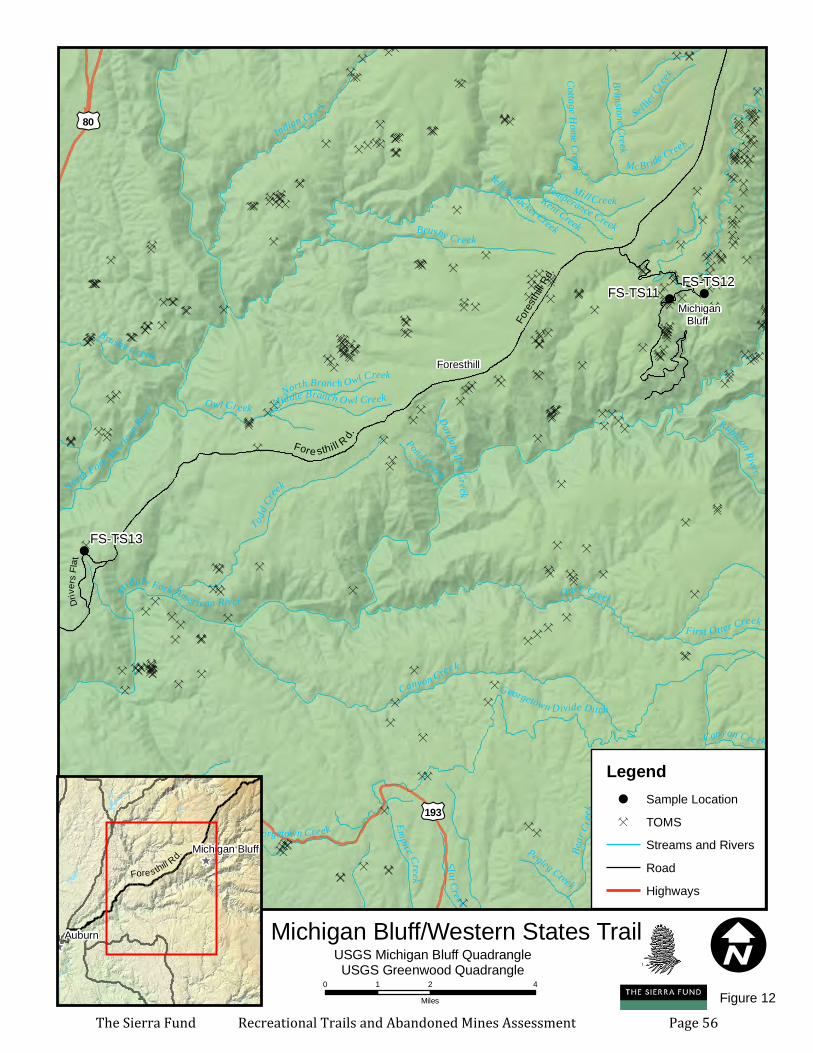
Ç
ÇÇÇÇÇ
Ç
ÇÇÇÇ
ÇÇÇ
ÇÇÇÇ Ç
ÇÇÇ
ÇÇÇÇÇ
Ç
ÇÇÇÇÇÇÇÇÇÇÇÇÇÇ
ÇÇÇÇÇÇÇÇÇÇÇÇ
ÇÇÇ Ç
ÇÇÇÇÇÇÇÇÇÇÇ
ÇÇÇÇÇ ÇÇÇ ÇÇÇÇ Ç
ÇÇÇÇ
ÇÇÇÇÇÇÇÇÇÇ Ç
Ç ÇÇ
ÇÇÇÇÇÇÇÇÇÇ
ÇÇ ÇÇ
ÇÇÇÇÇ
ÇÇÇÇÇÇÇÇÇÇÇÇÇÇÇÇÇÇÇ Ç
ÇÇÇ
ÇÇ
ÇÇÇ
ÇÇÇÇ ÇÇÇÇÇÇ
ÇÇÇÇÇÇÇÇÇÇ
ÇÇÇÇÇÇÇÇ
ÇÇ ÇÇÇÇÇÇ
ÇÇ
Ç ÇÇÇÇÇÇÇÇÇ Ç
Ç
ÇÇÇÇÇÇÇÇÇÇÇÇÇÇÇÇÇÇÇÇ ÇÇ
ÇÇÇ
ÇÇ
ÇÇÇÇ
Ç ÇÇ Ç
ÇÇ
ÇÇÇÇ ÇÇÇ
ÇÇÇÇ
ÇÇÇÇÇÇÇÇÇÇ
ÇÇÇÇÇÇÇÇ ÇÇÇÇÇÇÇÇÇ
ÇÇÇÇÇÇÇÇÇÇ ÇÇÇÇÇÇ ÇÇ
ÇÇ
ÇÇÇÇÇÇ
Ç ÇÇÇ ÇÇÇÇÇÇÇÇÇÇÇÇ
ÇÇÇÇÇÇÇÇÇÇÇÇÇÇÇ ÇÇÇ ÇÇÇÇÇÇÇÇÇÇÇÇÇ
ÇÇÇÇÇÇÇÇÇÇÇÇÇ ÇÇÇÇÇÇÇÇÇÇÇÇÇÇ ÇÇÇÇÇ
ÇÇÇ
ÇÇÇÇÇÇ
Ç
ÇÇÇÇÇ
ÇÇ ÇÇ
ÇÇÇÇ
Ç ÇÇÇ
ÇÇÇÇÇÇÇÇÇÇÇÇÇÇÇÇÇÇ
Ç
Ç
ÇÇÇÇÇÇ
ÇÇÇ
ÇÇ
ÇÇÇ ÇÇÇ Ç
ÇÇÇÇÇ
ÇÇ
ÇÇ
Ç
ÇÇ
ÇÇÇ
ÇÇÇÇ Ç
Ç
ÇÇ
ÇÇÇ
Ç Ç
ÇÇ
Ç
ÇÇÇÇ
ÇÇÇÇ
Ç ÇÇÇÇÇ
Ç ÇÇ
Ç
Ç
Ç
Ç
ÇÇ
ÇÇ
Ç
!!!!
!!!!!
! !
!
Foresthill
Michigan Bluff
£¤193
£¤80
FS-TS13
FS-TS12FS-TS11
Fores
thill R
d.
Otter Creek
Canyon Creek
Middle Fork American River
To dd Cr
eek
Rock
Creek
Indian Creek
North Fork American
River
Georgetown Divide Ditch
Brushy Creek
Bear
Cree
k
Mill Creek
Gree
nwood Creek
Penobscot Creek
Sel lier C
reek
Georgetown Creek Empire CreekOwl Creek
Slat Cr eek
Kent Creek
Brimstone Creek
Little Silver Creek
Rubicon River
Al Brass Creek
First Otter Creek
Mc Bride Creek
Pond Creek
Middle Branch Owl Creek
Pegleg Creek
Temperance Creek
North Branch Owl CreekDardanelles Creek
Cottage Home Creek
Yellow Jacket Creek
Canyon Creek
Brushy Creek
IMichigan Bluff/Western States Trail^
^
^
Auburn
Michigan Bluff
USGS Michigan Bluff QuadrangleUSGS Greenwood Quadrangle
Legend! Sample LocationÇ TOMS
Streams and RiversRoadHighways
Figure 12
Fores thill R
d.
Fore sthi ll R
d.
0 2 41Miles
Drive
r s Fla
t
The Sierra Fund Recreational Trails and Abandoned Mines Assessment Page 56
Tabl
e 12
: Mic
higa
n Bl
uff/
Wes
tern
Sta
tes
Trai
lSa
mpl
e N
ame
Sam
ple
Dat
eLo
catio
nA
sCr
PbA
sbes
tos
Com
men
tsm
g/kg
mg/
kgm
g/kg
%
FS-T
S11
6/1/
2009
Fore
sthi
ll55
251
16na
On
Wes
tern
Sta
tes
Trai
l in
tow
n of
M
ichi
gan
Bluf
f
FS-T
S12
6/1/
2009
Fore
sthi
ll<5
8520
naO
n W
este
rn S
tate
s Tr
ail w
est o
f M
ichi
gan
Bluf
fFS
-TS1
36/
1/20
09Fo
rest
hill
537
533
na F
ores
t Hill
Div
ide
loop
trai
l
mg/
kg=m
illig
ram
s pe
r ki
logr
am, n
a=no
t ana
lyze
d, (A
s=to
tal a
rsen
ic, C
r=to
tal c
hrom
ium
, Pb=
tota
l lea
d; a
naly
zed
by M
E-IC
P 61
ass
ay
met
hod)
(Hg=
tota
l mer
cury
ana
lyze
d by
Hg
-CV4
1 co
ld fu
rnac
e m
etho
d), (
Asb
esto
s=pe
rcen
t asb
esto
s, a
naly
zed
by C
ARB
Met
hod
435,
*Ch
ryso
tile,
**T
rem
olite
)
The Sierra Fund Recreational Trails and Abandoned Mines Assessment Page 57
Mining’s Toxic Legacy Initiative
RESOURCES
As a part of the Mining’s Toxic Legacy Initiative, The Sierra Fund is building a toolbox to help Sierra Nevada community members and leaders learn about and address the issue of legacy mining toxins. The following documents are available online at www.sierrafund.org:
Mining’s Toxic Legacy: An Initiative to Address Legacy Mining Toxins in the Sierra Nevada This 85-page report is the first-ever comprehensive look at the ongoing environmental, cultural and human health impacts of the Gold Rush. Also available: 8-page Executive Summary.
Protecting Public Health and the Environment from Legacy Mining Toxins: A Primer for Nonprofit Organizations in the Sierra Nevada
This document summarizes the key issues that confront land trusts and land and water conservation organizations working in the Sierra Nevada.
Protecting Public and Environmental Health from Legacy Mining Toxins: A Primer for Local Government Officials in the Sierra Nevada
This document summarizes the key issues that confront local government officials with legacy mining in their jurisdiction.
Building a Mining Toxins Working Group: A Blueprint for California This working document is meant to guide collaboration among and encourage community involvement in the many efforts to address legacy mining contamination in the Sierra Nevada.
Coming Soon:
2009 Gold Country Angler Mercury Exposure SurveyThe purpose of this study was to learn whether people who eat sport fish caught in Sierra Nevada waters are being exposed to mercury. The Gold Country Angler Survey targeted anglers who fish in mercury-impacted waterways to characterize fishing activities, fish consumption patterns, and health hazard awareness.
The Sierra Fund Recreational Trails and Abandoned Mines Assessment Page 58
w w w . s i e r r a f u n d . o r g
432 Broad Street - Nevada City, CA 95959(530) 265-8454 - [email protected]
T H E S I E R R A F U N D
The Sierra Fund Recreational Trails and Abandoned Mines Assessment Page 59