Embed Size (px)
Citation preview
Golden Ears Park
Management Plan
DRAFT
December 2012

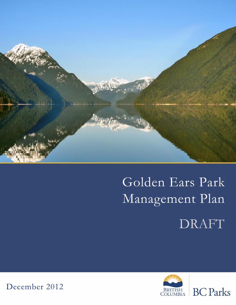
Photo on cover page: Alouette Lake. Credit: Xfshee, Panoramio (2008). This management plan replaces the direction provided in the 1976 Golden Ears Master Plan and the draft Golden Ears Management Plan (2002).
Golden Ears Park Management Plan
Approved by:
Brian Bawtinheimer Executive Director, Planning and Management BC Parks
Date
Brandin Schultz Regional Director, South Coast Region Ministry of Environment - BC Parks
Date

[blank page]
Golden Ears Park Management Plan ii
Table of Contents
1.0 Introduction ............................................................................................................... 3
1.1 Management Plan Purpose............................................................................................. 3
1.2 Planning Area .................................................................................................................. 3
1.3 Legislative Framework .................................................................................................... 6
1.4 Adjacent Patterns of Land Use........................................................................................ 6
2.0 Values and Roles of the Park ...................................................................................... 7
2.1 Significance in the Protected Areas System ................................................................... 7
2.2 Natural Heritage.............................................................................................................. 7
2.3 Cultural Heritage ........................................................................................................... 11
2.4 Recreation ..................................................................................................................... 13
2.5 Commercial Recreation and Services ........................................................................... 17
2.6 Encumbrances ............................................................................................................... 17
2.7 Education and Research................................................................................................ 18
3.0 Management Direction ............................................................................................. 19
3.1 Vision ............................................................................................................................. 19
3.2 Management Issues, Objectives, and Strategies .......................................................... 20
3.3 Zoning............................................................................................................................ 28
4.0 Plan Implementation ................................................................................................ 32
5.0 References ............................................................................................................... 32
Appendix 1: Appropriate Uses Table .................................................................................... 33
Appendix 2: List of Golden Ears Park Trails ........................................................................... 36
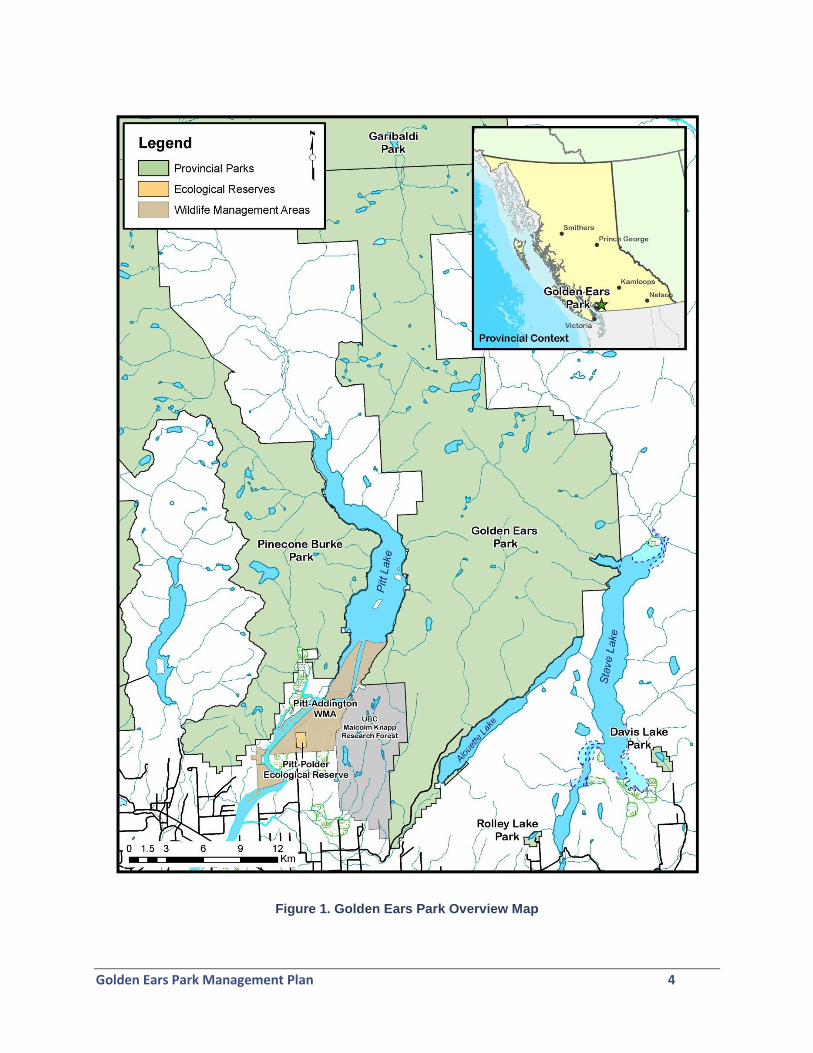
Figure 1. Golden Ears Park Overview Map ..................................................................................... 4
Figure 2. Golden Ears Park Zoning - Overview Map. .................................................................... 30 Figure 3. Golden Ears Park Zoning - Map of Zoning at the Southern End of the Park. ................ 31
Golden Ears Park Management Plan 3
1.0 Introduction
1.1 Management Plan Purpose
The purpose of this management plan is to guide the management of Golden Ears Park. The direction set out in this management plan is applied by protected area managers to make decisions regarding ongoing management and operations within Golden Ears Park. This management plan:
defines the role and significance of the park in the protected areas system;
identifies the significant features or values of the park;
outlines a vision for the park;
outlines management issues and opportunities; and
provides a future framework for operational decision making. This management plan for Golden Ears Park builds on, and replaces, the previous management plan for the park, originally formulated in 1963 and revised in 1976, and a conceptual plan that was developed for Golden Ears and Mount Judge Howay when it was established as a Recreation Area in 1976. The management plan is influenced by land use planning and management of the surrounding lands and waters, in particular the Malcolm Knapp Research Forest, and the Alouette and Stave reservoirs. Consideration is also given to BC Parks’ management objectives for the other provincial parks in the vicinity of Golden Ears Park, specifically Pinecone Burke Park and Garibaldi Park, the latter of which shares a common boundary with Golden Ears Park.
1.2 Planning Area
Golden Ears Park is situated on the north side of the Fraser River approximately fifty kilometres east of Vancouver in the District of Maple Ridge (Figure 1). The park conserves significant natural features typical of the Coast Mountains while providing a wide variety of recreation opportunities in close proximity to the large population of Metro Vancouver. Golden Ears Park is British Columbia’s fourth most visited provincial park, with an average attendance of over 615,000 visitors annually. Encompassing 62,539 hectares, Golden Ears Park is the second largest provincial park in the South Coast Region, after Garibaldi Park. The park is part of a protected area complex, which includes Garibaldi Park to the north and Pinecone Burke Park to the west. Together these three parks create a large expanse of connected protected wilderness totalling 2,875 square kilometres; this is one of 12 large park complexes in the province.
Golden Ears Park Management Plan 4
Figure 1. Golden Ears Park Overview Map
Golden Ears Park Management Plan 5
In the 1920s, the area that is now Golden Ears Park was part of one of the largest railway logging operations in the province, operated by the Lougheed and Abernathy Logging Company. In 1929, a spark from a locomotive caused an extensive forest fire which destroyed almost 60,000 hectares of forest and ended logging in the area. In 1933 - in recognition of the significant recreational values associated with the area’s scenic mountains and lakes - the province added the lands that are now Golden Ears Park to Garibaldi Park. There were plans to establish the area as a national park, however this did not proceed. In 1967, Golden Ears was split off from Garibaldi Park and established as a separate Class A park to provide more focus to the recreational features associated with the south end of the park in the vicinity of Alouette Lake. Mount Judge Howay Recreation Area was established at the same time as Golden Ears Park, and was upgraded to Class A park status in 1990. Mount Judge Howay Park was added to Golden Ears Park in 2000. In 1997, the Mystic Lakes area was identified for protection through the Lower Mainland Protected Areas Strategy process, adding 781 hectares to Golden Ears Park. The Mystic Lakes area is located on the western slopes of the park and protects a system of lakes in the headwaters of Fish Hatchery Creek which flows west into the Upper Pitt River. Situated within the Coast Mountains, Golden Ears Park features spectacular mountain peaks, including the peaks of Mount Blanchard, referred to as the “Golden Ears” which feature prominently in the Lower Mainland. Golden Ears Park contains the headwaters of three major rivers: Stave River, Alouette River, and Upper Pitt River, and more than twelve smaller tributary creeks. The park attracts visitors from across the Lower Mainland and other areas to enjoy camping, hiking, horseback riding, and lake-oriented activities such as swimming, fishing, and boating. Alouette Lake is suitable for swimming in the summer months and has three popular sandy beaches. Although the lake is not within the park boundaries, its western and southern shores are in the park and are the main focus of recreation. Within the park, an extensive trail system provides opportunities for hiking, backpacking, biking and horseback riding. Golden Ears Park features three campgrounds - one of which is the largest in the province - and two popular day use areas. The day use area at the southern end of Alouette Lake receives thousands of visitors per day during summer weekends. The primary access to Golden Ears Park is by the main park road, Golden Ears Parkway, via Fern Crescent in Maple Ridge. There is foot or bicycle access to the east side of the park by way of 248th Street and 256th Street, although these access routes travel through private lands which are gated to prevent vehicle access. The west side of the park borders Pitt Lake and is accessible only by boat. A small section of the park borders Stave Lake in the east and is also accessible only by boat.
Golden Ears Park Management Plan 6
1.3 Legislative Framework
Golden Ears Park is a Class A park named and described in Schedule C of the Protected Areas of British Columbia Act. Management activities and development are constrained by the Park Act. Class A parks are dedicated to the preservation of their natural environments for the inspiration, use and enjoyment of the public.
1.4 Adjacent Patterns of Land Use
Golden Ears Park occupies the majority of land bridging the watersheds of the Pitt and Stave rivers, extending northward to the southern boundary of Garibaldi Park. The park is predominantly bordered by forested lands managed as part of the Chilliwack Forest District. The park boundary adjoins three lakes - Pitt Lake to the west, Alouette Lake to the south and Stave Lake to the east in the vicinity of Clearwater Bay. There are a number of private properties and communities adjacent to the park including Williams Landing on Pitt Lake and the community of Silver Valley at the south end of the park in the municipality of Maple Ridge. The University of British Columbia’s Malcolm Knapp Research Forest encompasses 5,157 hectares of coastal forest from the eastern shore of Pitt Lake to the western boundary of Golden Ears Park. The primary focus of the Research Forest is to encourage and facilitate research and educational use, but is also recognized as an important area for community recreation. Recreational opportunities include walking and hiking trails, canoeing and rock climbing. Some access restrictions apply to protect the integrity of the site. Blue Mountain, located on the south-eastern shore of Alouette Lake is an area of forested Crown land approximately 400 hectares in size that is managed under a woodlot licence. The Forest Act and Forest and Range Practices Act regulate land use and natural and cultural resource management on Crown land in BC. Blue Mountain provides opportunities for recreational activities such as hiking and horseback riding as well as motorised sports including motor biking, all-terrain vehicle use and snowmobiling. Motorised activities are not permitted within Golden Ears Park; however there have been issues with incursions into the park by motorised users, which is predominantly an issue on the east side of Alouette Lake, in the vicinity of Blue Mountain. The Province is currently developing a recreational plan for the Blue Mountain area, including designating motorised and non-motorised trails and developing parking areas and signage. BC Parks is engaged in this planning process and is working with adjacent landowners to prevent motorised access into the park. The Alouette Dam, operated by BC Hydro, is located at the southern end of Alouette Lake adjacent to the park boundary and day use area. This dam controls the Alouette Reservoir which encompasses Alouette Lake and regulates water levels in the lake.

Golden Ears Park Management Plan 7
2.0 Values and Roles of the Park
2.1 Significance in the Protected Areas System
Golden Ears Park is significant in the protected areas system because it:
Contributes to the protection of a continuous mosaic of wilderness totalling 2,875 square kilometres, one of 12 large protected complexes in the province;
Is one of the most visited parks in the province offering a wide range of recreation opportunities to people in the Lower Mainland;
Contributes significantly to the protection of the headwaters of three large river systems in the Lower Mainland: the Stave, Alouette, and Upper Pitt rivers.
Protects habitat for a number of species at risk including a threatened population of Grizzly Bear (the Garibaldi-Pitt population unit), rare plants, and red- and blue-listed insects, amphibians, mammals, and fish.
Protects significant winter range habitat for ungulates, including Mountain Goat.
Contains archaeological evidence of habitation and other important cultural sites including pictographs.
2.2 Natural Heritage Values
Water
Golden Ears Park is bordered by three large lakes that provide the primary focus for recreation in the park: Alouette Lake, Pitt Lake and (to a lesser extent) Stave Lake. While these lakes attract visitors to the park for boating and other water-oriented activities, they are not within the park boundary. In the frontcountry of the park, important aquatic features include Mike Lake, the Alouette River, Gold Creek, and the bog habitats accessed by the Spirea Nature Trail. Backcountry areas of the park, although difficult to access, feature mountain lakes, rivers and streams including Thomas, Tingle, Judicator, and Kunzelman lakes, the Mystic Lakes area, Tingle Creek, Raven Creek, Glacier Creek, Moyer Creek, and the North Alouette River. Vegetation
Golden Ears Park spans three ecosections - Eastern Pacific Ranges, Southern Pacific Ranges and the Fraser Lowlands. The predominant ecosystems in the park include three biogeoclimatic zones: Mountain Hemlock, Coastal Western Hemlock, and Coastal Mountain-Heather Alpine. Golden Ears Park provides protection for over 4,000 hectares of the under-represented Coastal Western Hemlock dry maritime biogeoclimatic subzone, comprising 15% of the subzone’s total area that is within the province’s protected areas system.
Golden Ears Park Management Plan 8
The Alouette River valley was the site of major railroad logging operations in the 1920s, which harvested the majority of large old growth cedar and hemlock in the valley. In 1931, a severe fire permanently ended all forest harvesting. Today, second growth forest covers the logging scars of the past, but evidence of logging can still be seen. Some of the forest has regenerated at different rates, becoming a mosaic of both deciduous and coniferous species. However there are large stands of even-aged forest - a result of past logging and fire - that are not representative of the historic composition and structure of the forest. Due to a diversity of terrain and elevation, Golden Ears Park supports a range of forest communities. Vegetation varies from dense understory vegetation, such as red alder and vine maple below canopies of Douglas-fir and amabilis fir, western hemlock and yellow-cedar, to sparse high elevation krummholz trees associated with white mountain-heather, mosses and lichens. While its presence has not been confirmed, the red-listed Douglas-fir - lodgepole pine / oceanspray / reindeer lichen plant community may be present at lower elevations in the southern end of the park1. The plant community occurs in small patches within the Coastal Western Hemlock dry maritime biogeoclimatic subzone and is located on ridge crests, hilltops and south-facing slopes (Warttig and Inselberg, 2010); site conditions that are found along the eastern shore of Pitt Lake and the shores of the lower Alouette Lake. Several species of rare vascular plants occur, or are believed to occur, in Golden Ears Park. There is a known occurrence of the blue-listed snow bramble on Alouette Mountain. This low-lying perennial species is associated with moist forests and glades in the montane zone and is rare in southern British Columbia. The blue-listed coastal wood fern, bigleaf sedge, and Menzies' burnet have been confirmed within the UBC Malcolm Knapp Research Forest and likely occur in the park as well. Golden Ears Park has suffered outbreaks of Western Hemlock Looper, a defoliating insect native to British Columbia that usually affects mature stands and can result in tree mortality. The last large outbreak was in 2000, and although larvae were present in the park, there was no significant defoliation2. The Province continues to monitor and treat infestations, although Western Hemlcok Looper outbreaks are considered to be natural disturbance events that are important in the life cycle of the forest. Wildlife
The diversity of habitats in Golden Ears Park supports a large variety of bird, amphibian, fish, insect and mammal species. Two red-listed insect species, Johnson’s Hairstreak (butterfly) and Grappletail (dragonfly), occur in the vicinity of the park, as well as two blue-listed dragonflies: Autumn Meadowhawk and
1 Warttig, W. and Inselberg, A. (2010). BC’s Coast Region Species and Ecosystems of Conservation Concern.Factsheet for the South Coast Conservation Program, 2pp.
2 Ebata, Tim (2011). Personal communication.
Golden Ears Park Management Plan 9
Beaverpond Baskettail. These species have been observed in the Malcolm Knapp Research Forest and likely occur in the park, although this has not been confirmed. Nearly 140 species of birds have been recorded in the park.3 The Mike Lake area is regarded as the best birding site in the park. Species found in this area include waterfowl, vireos, warblers, Common Loon, Pied-billed Grebe and flycatching birds including Cedar Waxwing, Willow Flycatcher and swallows.4 The red-listed Northern Goshawk (laingi subspecies), and the blue-listed Green Heron and Great Blue Heron likely occur in the park. The bog accessed by the Spirea Nature Trail is good for viewing birds, aquatic insects, and amphibian and reptile species. Several rare amphibians and reptiles have been reported in the park and include the blue-listed Coastal Tailed Frog and Northern Red-legged Frog, the red-listed Painted Turtle (Pacific Coast population) and Pacific Giant Salamander. Smaller mammals are quite abundant in the park, including several species of moles and shrews, Snowshoe Hare, Douglas Squirrel, Yellow-pine Chipmunk, Northern Flying Squirrel, and bats. The red-listed Pacific Water Shrew was recently discovered in wetland areas at the southern end of the park. Since the early 2000s, a number of American Beaver have been released into Mike Lake in an effort to reintroduce this species to this part of the park. Reintroduction efforts have had limited success, although beaver damming of the lake has resulted in sustained lake levels. The surrounding forest lacks adequate diversity of deciduous browse species to support beaver, so careful management is required to ensure their long-term viability. The park provides habitat for larger mammals including the Black-tailed Deer, Mountain Goat, American Black Bear, Cougar, and the blue-listed Grizzly Bear and Wolverine (luscus subspecies). Bobcat, Marten and the blue-listed Fisher also occur in the park. Roosevelt Elk were reintroduced in the upper Stave Lake and Pitt Lake areas in 2008-2009 and occur within the park. Future elk introductions are also being considered for areas within the park, including the Gold Creek watershed5. The park is situated within the Garibaldi-Pitt Grizzly Bear population unit (GBPU), a threatened population unit from which Grizzly Bears were thought to have been extirpated. However, in the summer of 2011 a Grizzly Bear was recorded in the upper Pitt River area, between Golden Ears and Pinecone Burke parks, so it is possible Grizzly Bear occur in low numbers in the northern regions of the park. The Sea to Sky Land and Resource Management Plan (LRMP) states a goal to “achieve and maintain a viable status for each of the four grizzly bear population units that overlap the plan area.” To reach this goal, the Sea to Sky LRMP requires
3 Grass, Al (1995). Golden Ears Provincial Park Bird Checklist.
4 British Columbia Wildlife Watch. http://www3.bc.sympatico.ca/driftwood/bcwwhome.htm
5 Reynolds, Darryl (2011). Personal communication.
Golden Ears Park Management Plan 10
the development and implementation of recovery plans for each of the four GBPUs – including the Garibaldi-Pitt population unit. Fish
The lakes, rivers, and tributary streams of Golden Ears Park provide habitat for more than twenty species of fish. Damming of the Alouette River in 1928 reversed most of the outflow drainage and blocked spawning migrations of Sockeye, Chinook, Pink, Coho, Chum, Steelhead and possibly sea-run Cutthroat Trout. Chinook utilized Gold Creek as their preferred natal stream. Damming resulted in localized extinction of several stocks and decreased the natural nutrient load to Alouette Lake. Since 2000, there have been efforts by the Alouette River Management Society, Katzie First Nation, BC Hydro, and other partners to re-establish spawning salmon to Alouette Lake. Salmon smolts have been released into the lake to assess their success in migrating downstream over the dam spillway. Fish are captured in a trap below the spillway in order to assess levels of escapement. One of the interesting results of this work has been the successful migration of Kokanee from the lake. Some of these fish have been tracked into the Salish Sea, resulting in their nickname “Sockanee”. Subsequently, efforts are underway to assist the return of migrating salmon to the lake, through the trapping and trucking of fish upstream around the dam. Due to impacts associated with damming, nutrient levels in Alouette Lake are low. The Alouette Reservoir Fertilization Project regularly provides supplemental nutrients to the lake to restore the reservoir to its historical productivity. The fertilization project is reviewed on a 5-year basis to confirm that the project is continuing to meet its productivity objectives. As long as the project continues to be successful in maintaining aquatic productivity, BC Hydro will continue to support fertilization of the lake. Pygmy Longfin Smelt is a red-listed population of smelt that has become independently established in Pitt Lake, Harrison Lake and Lake Washington. This species is preyed on by Chinook Salmon, Rainbow Trout, and White Sturgeon. Pygmy Longfin Smelt typically spawns in inlet streams in November or December, so would likely be utilising creeks within the park that flow into Pitt Lake. There is little known with regards to their biology, abundance and population trends.
Golden Ears Park Management Plan 11
Natural Heritage - Role
Protects a large, remote wilderness area located in close proximity to a large urban centre.
Provides protection for over 4,000 hectares of the Coastal Western Hemlock dry maritime biogeoclimatic (BEC) subzone, which represents 15% of this BEC found in the protected area system.
Provides habitat for species that are dependent on minimal human disturbance, including Grizzly Bear, Wolverine, wolves, and Mountain Goat.
Protects habitat for a number of species at risk including: the threatened Garibaldi-Pitt Grizzly Bear population unit, and the red-listed Johnson’s Hairstreak butterfly, Grappletail dragonfly, Northern Goshawk (laingi subspecies), Pacific Water Shrew, Painted Turtle, Pacific Giant Salamander, and Pygmy Longfin Smelt.
2.3 Cultural Heritage Values
First Nations’ Historical and Ongoing Use
Golden Ears Park is situated within the traditional territories of the Katzie First Nation, Kwantlen First Nation, Matsqui First Nation, Tsawwassen First Nation, Sto:lo Nation, In-SHUCK-ch Nation, Sts’Ailes First Nation and the St’at’imc/Lillooet Tribal Council. For thousands of years First Nations have occupied and used the area that is now encompassed by the boundaries of Golden Ears Park for hunting, trapping, fishing, and gathering, and for social and ceremonial purposes. Oral histories, ethnographies, and results of archaeological studies describe resource use by First Nations in Pitt Lake, the upper Pitt River, Stave Lake, and Stave River. These sources emphasise the economic and cultural importance of this area to the First Nations. For many First Nations, the land, water and natural resources found within the boundaries of Golden Ears Park continue to hold spiritual, economic, and social value. The Katzie people once maintained at least ten ancient villages within their traditional territory, several of which were situated in close proximity to Golden Ears Park. In addition, seasonal encampments and sacred sites were located in adjacent upland areas, many of which are now encompassed by the park. Katzie’s three residential reserves are situated within ten kilometres of the park boundary. Ethnographic sources indicate that Katzie resource use is primarily associated with the southern and western portions of the park, in the vicinity of Pitt Lake and Alouette Lake. Katzie oral histories and ethnographic sources suggest that Katzie members travelled overland between Pitt Lake and Alouette Lake for various resource gathering activities, including deer and Mountain Goat hunting and fishing. Stone tools from archaeological sites along the western shore of Alouette Lake indicate that fishing has been taking place within the area for thousands of years (Katzie First Nation, 2011). Both anadromous and freshwater fish were harvested in the park area including five species of Pacific salmon, Steelhead, trout and chub. The construction
Golden Ears Park Management Plan 12
of the Alouette Lake dam blocked the passage of Pacific salmon and Steelhead populations which spawned in Alouette Lake and River. Katzie is working in partnership with BC Hydro and the Alouette River Management Society in ongoing efforts to return salmon stocks to Alouette Lake and its rivers. The surrounding watersheds and riparian areas were used for plant gathering. Some of the many plant resources harvested include cedar bark, berries, and Wapato (Sagittaria latifolia). In an effort to ensure plant resources are available for future generations, Katzie is engaged in a long-term study documenting the diversity and abundance of plants in the riparian zone of Alouette Lake. Preliminary field observations suggest recreational users may be impacting these ecosystems, in particular where there is camping and day use in undesignated sites. First Nations hunted and trapped mammals, grouse and waterfowl in the park area. Mammal species harvested included Mule Deer, Roosevelt Elk, Mountain Goat, Black Bear, and other smaller animals such as American Beaver and American Marten. The St’at’imc and Lillooet people are associated with the park’s northern sections, including areas in the vicinity of Tingle Creek and the upper Stave River. A historic trading route once existed through the park. First Nations groups from the Interior used the route to access seasonal resources in the upper Stave and Pitt watersheds, and it is possible that the route was also used as a trade corridor to the Interior. Current research indicates that the corridor may be evidenced in the form of trails that connect to Alouette Lake. Kwantlen First Nation is primarily associated with the Stave Lake and Stave River, both situated in the southeast area of the park. This area was used extensively for hunting and trapping and was an important training ground for Kwantlen youth and other Sto:lo hunters. There are 13 registered recorded archaeological sites within the park boundaries and several more located just outside the park. Archaeological sites include lithic scatters, pit features, and rock art sites. The number and variety of archaeological sites indicate the land and resources now situated within the park boundaries were used for many years; some year-round, and others on a more seasonal basis. The majority of these archaeological sites are in areas of recreational use, and will require careful management to prevent disturbance. In 2009, the Tsawwassen First Nation Final Agreement was ratified. The Tsawwassen Wildlife Harvest Area, Tsawwassen Migratory Bird Harvest Area, and Tsawwassen Plant Gathering Area overlap Golden Ears Park as defined in the Tsawwassen First Nation Final Agreement. Under treaty, Tsawwassen First Nation has the right to harvest wildlife and migratory birds and gather plants within Golden Ears Park for domestic purposes, subject to an approved gathering plan. History of Industrial Resource Use
In 1897, a copper mine was opened in the park area which operated an aerial tramway from the mine site located approximately a kilometre east of Pitt Lake down to the lake. During the
Golden Ears Park Management Plan 13
1920s Lougheed and Abernathy Logging Company and B&K Logging Company logged the eastern shores of Pitt Lake and most of the southern portion of the park. During this time, the park area was the site of the largest railroad logging operation in North America. Reminders of the logging era are evident throughout the park in the form of charred stumps, abandoned steam donkey sleds and railroad ties. Originally, Alouette Lake was two lakes, called the Lillooet Lakes, which were separated by a short stretch of the Alouette River. In 1926 the Alouette Dam was constructed across the Alouette River at the south end of Alouette Lake. The subsequent flooding created a 17 kilometre-long reservoir. The Alouette Lake reservoir became part of the interconnected Alouette-Stave-Ruskin generating system when a tunnel was bored into the northeast corner of the reservoir to divert water to Stave Lake. The system generates electricity for BC Hydro and provides flood control for the Alouette River. In 1927, the Dominion Forestry Service planted three tree plantations to test the suitability of certain exotic tree species to the coastal climate. Eight different species remain, including the Giant Sequoia, Dahurian Larch, Japanese Larch, Red Oak, White Ash, Sugar Maple, White Spruce, and Scotch Pine. These trees are found in several groves which are situated in the southern end of the park.
Cultural Heritage - Role
Protects an area where First Nations can continue to practice fishing, hunting and gathering, social, and ceremonial activities.
Provides an opportunity to inform the visiting public about BC’s logging history.
2.4 Recreation Values
With a variety of land and water-based recreation, Golden Ears Park plays a significant role for outdoor recreation and tourism in the region. The value of the recreational opportunity available in the park is magnified by its close proximity to the large population base of the Lower Mainland. Boating and Canoeing
Lakes within and bordering Golden Ears Park provide a wide variety of boating opportunities. Pitt and Stave lakes are excellent for motor boating, as is Alouette Lake, which is also suitable for sailing, kayaking and canoeing. The Alouette Lake reservoir is drawn down in the fall, although lake elevation is maintained above 121.25 metres between May (Victoria Day) and September (Labour Day) for recreational purposes. There is a boat launch in the park at Alouette Lake, and a commercial canoe rental. An 8 km/h speed zone applies to the southern portion of Alouette Lake but there are no horsepower restrictions.
A boat launch for Alouette Lake is located north of the day use area, with an adjacent parking lot for approximately 100 boat trailers and vehicles. This boat launch and parking area is often
Golden Ears Park Management Plan 14
crowded on busy summer weekends, with lineups of boaters extending to the main access road, waiting to access the boat launch and parking. Public boat launches outside the park provide access to Pitt Lake and Stave Lake.
Increased erosion associated with wakes from boating is affecting the stability of the shoreline of Alouette Lake and potentially impacting archaeological sites. There is also a concern that boaters are landing their boats in areas where they are impacting the riparian area and potentially impacting archaeological features. Furthermore, there is an issue with motor boats entering into the mouth of Gold Creek which presents a safety risks to other park visitors in this popular swimming area. Trails
Golden Ears Park offers an extensive system of hiking trails of varying length and difficulty, leading to lookouts, waterfalls and alpine areas. Self-guided nature trails allow easy exploration of some of the park’s natural values, within a relatively short walking distance.
Over sixty kilometres of trails provide access to some of the more remote areas of the park including Alouette Mountain and the “Golden Ears” of Mount Blanshard. Many of the trails are open to a variety of user groups including hikers, mountain bikers, and horseback riders. There are also hiking routes to Mount Robbie Reid, Mount Nutt, and to other more remote areas of the park.
Horseback riding is a popular activity within Golden Ears Park. A horse corral is located near the park entrance and several hitching racks are located within the park. Over forty kilometres of trails are designated for equestrians, including the Alouette Valley Trail, the Incline and Fire Access Trail, Mike Lake Trail, Menzies Trail, Alouette Mountain Trail, and East Canyon Trail. A slope failure on the East Canyon Trail has made the section to Hector Ferguson Lake impassable to horses.
Mountain biking is permitted on park roads and on some of the trails including the Fire Access Trail, the East Canyon Trail, the Menzies Trail, the Eric Dunning Trail, and the North Beach Service Road.
A full list and description of the park trails are provided in Appendix C. Day Use
Day use activities within Golden Ears Park are very popular, with some 100,000 parties visiting the Alouette Lake day use areas annually. Parking for the South Beach day use area accommodates a maximum 850 vehicles between two lots. The maximum capacity is reached on several occasions each year and the main gate is temporarily closed until parking spots become available.
The portion of the park on the southeast shore of Alouette Lake provides the best opportunity to expand boat-accessible day use and lake-oriented activities.
Golden Ears Park Management Plan 15
Frontcountry Camping
Alouette Lake offers one of the largest vehicle-accessed camping areas in the province, providing a total of 450 campsites located within three campgrounds and two group sites. Alouette campground offers 205 sites, Gold Creek campground 148 sites (including two barrier-free sites), and North Beach campground 55 sites. The remaining sites are within the group campsites.
In addition to vehicle accessible campsites, walk-in camping areas are found in frontcountry areas of the park. Trails from Alouette and Gold Creek campgrounds access Campers Beach on the southern shore of Gold Creek. North Beach on the north shore of Gold Creek is also accessible by foot. Backcountry Camping
There are designated backcountry campsites at Alder Flats, near the mountain shelter on the Golden Ears Trail, and at Viewpoint Beach and Half Moon Beach on the East Canyon Trail. The campsites at Alder Flats are situated in the riparian area of the creek which results in greater potential for wildlife encounters and impacts to riparian habitats. Lake Beautiful, was closed to camping in the 1976 management plan. This small sub-alpine lake is highly sensitive to recreational use, and is easily accessed from the Alouette Mountain Trail. It is therefore not a suitable location for backcountry campsites.
There are designated backcountry campsites on the shores of Pitt Lake, at Raven Creek, North Osprey Creek and South Osprey Creek. On Alouette Lake, marine campsites are located at Moyer Creek, Alouette Lake Narrows, and at the Alouette River Inlet. All marine campsites are accessible only by boat.
Unregulated camping and day use along the western shoreline of Alouette Lake has been observed to be causing increased shoreline erosion, point source pollution from human and boat waste, and trampling of culturally and ecologically significant plant resources. It is possible that this use is resulting in the reduction of species richness in the littoral zone, and may also be disturbing archaeological sites and spreading invasive species. The collection of coarse woody debris for campfires is potentially damaging littoral ecosystems and corresponds with a greater fire risk in these areas, particularly when unauthorised campfires occur during fire bans. Winter Recreation
Golden Ears Park provides limited opportunities for winter recreation. The Gold Creek campground, backcountry campsites, and all trails remain open to winter visitors. When snow cover is sufficient, snowshoeing and cross-country skiing may be enjoyed on the horse trails or the Alouette Mountain Trail. Ice-skating is possible on Mike Lake when the ice is thick enough.
Winter recreationalists have expressed concerns with gate closures and limited access to the park in the winter months, particularly after snowfall when the park gate is often closed.
Golden Ears Park Management Plan 16
Hunting and Fishing
Golden Ears Park is closed to hunting and the discharge of firearms, bows and crossbows under provincial regulation. However, the exercise of aboriginal rights to fish, hunt and gather continues within the park boundaries. Alouette Lake has been stocked with Rainbow Trout, Cutthroat Trout, and Steelhead but is no longer stocked due to the lake’s large size and successful natural production. Gold Creek was last stocked in 1983 with Steelhead. Thomas Lake and Mike Lake have been stocked with Rainbow Trout. A native population of coastal Cutthroat Trout (Oncorhynchus clarkii clarkii) was historically present in Mike Lake, and was recorded there prior to lake stocking. The clarkii subspecies of Cutthroat Trout is blue-listed, and populations in the Lower Mainland are in serious decline. There is a chance that the population in Mike Lake is extant and could recover if stocking ended. Stocked fish compete with native populations for food and habitat. Along with stocking, fishing at Mike Lake may be having an adverse impact on the native Cutthroat Trout population. The Alouette River is closed all year to fishing above signs near the Alouette River Corrections Unit, and above 216th Street (including the North Alouette River) between May 1 and June 30 to protect spawning salmon runs. Aircraft Access
Levels of aircraft use to these backcountry lakes is not well understood, nor does BC Parks have an understanding of whether or not commercial aircraft operators are accessing these more remote areas of the park.
Mountain Goat is an easily stressed species and human use, in particular aircraft use, is known to cause distress and habitat avoidance in Mountain Goat. Wolverine is another species that occurs in the park and is known to be negatively affected by aircraft and human use. Any aircraft access to the park will need to be managed to minimise impacts to Mountain Goat and Wolverine which will require further assessment and monitoring.
Although outside the park boundary, floatplane landings on Alouette Lake may be posing a safety risk for park visitors boating on the lake. Visual Landscape
The many mountain peaks, valleys, lakes and streams within Golden Ears Park combine to create diverse and spectacular views. Visitors to the park are often drawn to the shores of Alouette Lake, where much of the park’s activity is focused. However, most of the forested slopes surrounding the eastern shore of the lake are not within the park boundary, and the land is subject to forest harvesting and potential development.
Forest regeneration has impeded views of Alouette Lake from the park access road and at key viewpoints and lookouts. The lack of natural disturbance in the frontcountry areas of the park
Golden Ears Park Management Plan 17
has also resulted in uniform forest age and structure. This has reduced light penetration to the forest floor, preventing the growth of plants in the sub-canopy. This is an issue in the park campgrounds which can be dark, with little vegetation between sites to provide privacy. Selective tree cutting around campgrounds in other parks in the region has been successful in restoring undergrowth and improving light conditions in campgrounds.
The dam, tree stumps, and low water levels can detract from the visual quality of Alouette and Stave lakes, especially during the fall when lake levels are drawn down.
Recreation - Role
Provides the largest vehicle-accessible campground in the province.
Provides a system of trails for park users with a diverse range of abilities and activities which includes trails for hiking, horseback riding, and mountain biking.
Provides a range of recreational opportunities focussed on a lake setting, including swimming, boating, and backcountry marine camping.
2.5 Commercial Recreation and Services
Golden Ears Park is part of a bundle of parks operated under contract with a park facility operator. The park facility operator manages the frontcountry areas of the park, including all the vehicle-accessible campgrounds, the day use area on the east side of Alouette Lake and trails within one-kilometre of the main access road. The park facility operator currently runs a concession store and canoe rental.
There is a multi-year commercial recreation permit for a trail running race which is held in the park.
Golden Ears Park is a popular location for commercial filming. Filming primarily occurs in the frontcountry areas of the park. As filming typically occurs in areas where there are high levels of public use, it is important that filming activities do not unreasonably interfere with the public’s use and enjoyment of the park.
2.6 Encumbrances
BC Hydro holds a park use permit for a transmission line and associated structures. The transmission line crosses Golden Ears Park south of Alouette Lake, in the vicinity of the park access road. In 2012, this section of the transmission line is being upgraded and twinned as part of the Interior-to-Lower Mainland project.
Two provincial ministries also hold park use permits associated with other infrastructure including waterlines and communication sites.
Golden Ears Park Management Plan 18
2.7 Education and Research
Education
Visitors to Golden Ears Park are presented with a number of opportunities for education and outdoor study. Wherever possible BC Parks should seek opportunities to: 1) teach park visitors about the park’s cultural and natural history, 2)present key park messages around no-trace camping, being “bear aware”, and preventing the spread of invasive species, and 3) educate park visitors on the role they can play in protecting park wildlife and sensitive habitats.
There are interpretive nature trails with signage describing natural features as well as the park’s cultural history and heritage. The Spirea Nature Trail offers interpretive panels along a barrier-free trail. The Tiarella Nature Trail is a self-guided interpretive trail in close proximity to the Alouette campground; this trail has deteriorated over recent years and is in need of upgrades.
During the summer season, interpretive programs have been offered by the park facility operator to assist visitors in understanding and enjoying the park.
The Katzie Cultural Education Society holds a park use permit to operate educational programs at North Beach at a facility called the Outdoor Learning Centre. The permit extends until 2017. The Outdoor Learning Centre provides cultural and environmental education for students throughout the Lower Mainland. Educational programs and activities at the centre have been reduced since the longhouse burned down in 2006. A new shelter, recently installed, is expected to improve the delivery of educational activities at the site.
Research
BC Parks needs to explore opportunities to partner with local organisations and academic institutions, including the Malcolm Knapp Research Forest, on research and inventory projects in the park. Projects focussed on providing information that assists in adaptive park management would be priorities, including studies on forest and ecosystem health, invasive species, climate change (and associated management implications), species and communities at risk and the status of key wildlife populations (e.g., Mountain Goat, Wolverine, and Grizzly Bear).
Citizen science could be explored as an approach for engaging park visitors and volunteers in park research, while providing a valuable educational opportunity for the public.
There may also be opportunities to partner with First Nations in researching the archaeological and ethnographic histories associated with the park, to contribute to our understanding of the cultural values associated with the area.
Currently there are five research permits in the park.
Golden Ears Park Management Plan 19
Golden Ears Park is a place where park visitors can experience wilderness, ecosystems are preserved, and important ecosystem values such as species-at-risk are understood and protected. Here, park visitors can develop a better appreciation of nature through a well-maintained network of trails that provides a range of park visitors with opportunities to enjoy the park’s natural surroundings. Park visitors can also enjoy recreating in a lakeside setting while having a minimal impact on ecosystems and archaeological values. Golden Ears Park is a place where First Nations can practice their culture, and where park visitors can learn about, and celebrate First Nations traditions and history. Volunteerism is a core asset to Golden Ears Park and is recognised as a way for people to connect with, and develop a commitment to the park and its values.
3.0 Management Direction
3.1 Vision
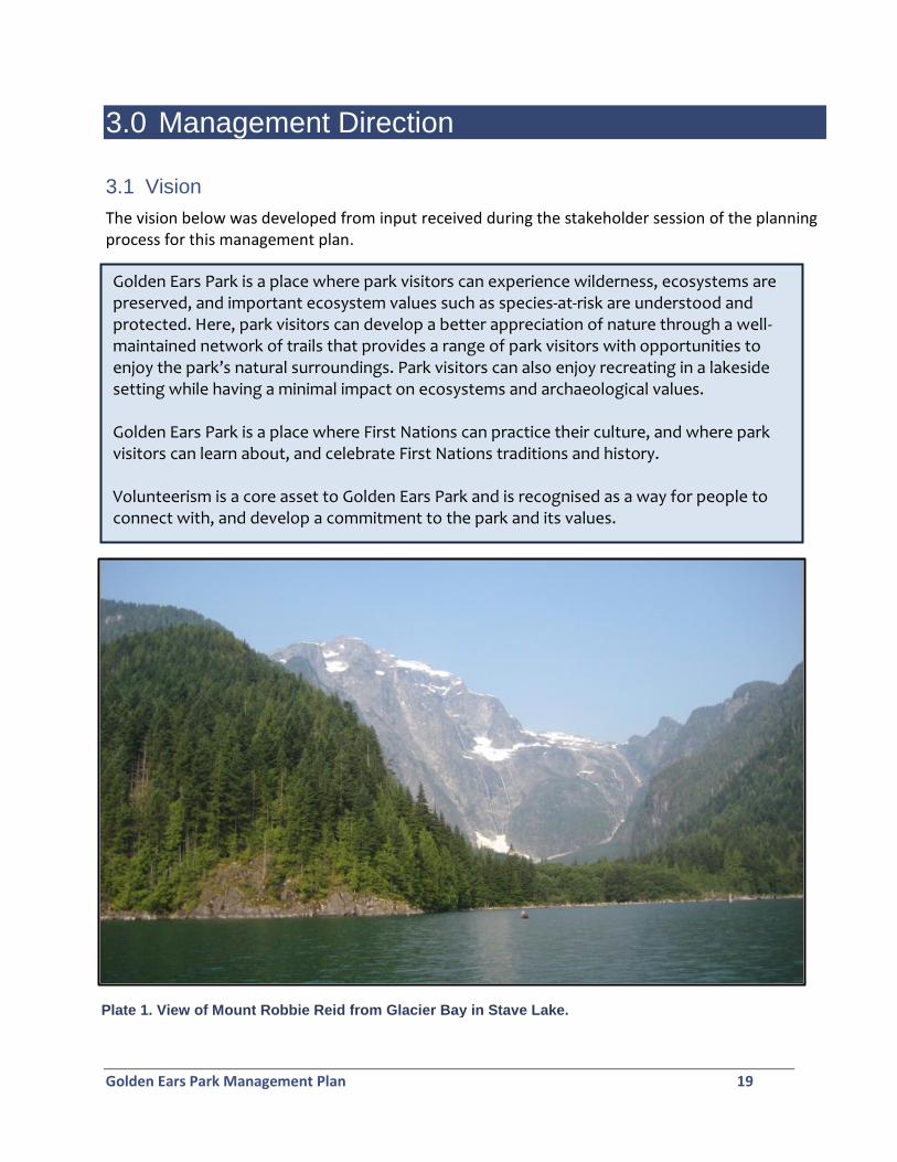
The vision below was developed from input received during the stakeholder session of the planning process for this management plan.
Plate 1. View of Mount Robbie Reid from Glacier Bay in Stave Lake.
Golden Ears Park Management Plan 20
3.2 Management Issues, Objectives, and Strategies
The following table summarizes the management issues, objectives and strategies for the park.
Management Issues and Opportunities
Management Objectives and Strategies
Issue: Ecosystem values are being impacted by recreational use.
Objective: Develop appropriate facilities and infrastructure to mitigate impacts from backcountry use.
Specific strategies:
Install food caches, pit toilets, fire pits, and tent pads at all designated backcountry campsites, including marine sites.
Relocate backcountry campsites at Alder Flats out of the riparian area of Gold Creek.
Maintain the closure to backcountry camping at Lake Beautiful.
Using BC Parks’ Backcountry Recreation Impact Monitoring process, monitor impacts associated with backcountry camping and use in the riparian areas of Alouette Lake. Consider implementing campsite and/or area closures to minimise impacts.
Work with appropriate agencies to provide designated boat landing sites (including docks and/or mooring buoys) at marine day use areas and campsites. Discourage boaters from accessing the shore at areas other than designated landing sites and access points through signage.
Using BC Parks’ Backcountry Recreation Impact Monitoring process, monitor trail erosion and braiding. Realign and/or relocate trails as needed, and/or install boardwalks.
Provide signage at boat launches and other park access points to promote no trace camping.
Provide educational signage on the ecological importance of coarse woody debris, and discourage collection of coarse woody debris for firewood.
Solicit the help of volunteer groups to assist in monitoring and maintaining backcountry facilities.
Golden Ears Park Management Plan 21
Management Issues and Opportunities
Management Objectives and Strategies
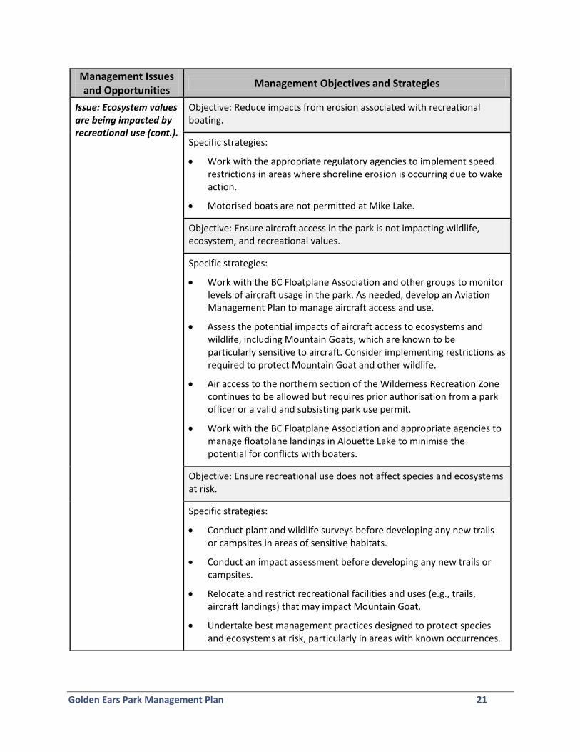
Issue: Ecosystem values are being impacted by recreational use (cont.).
Objective: Reduce impacts from erosion associated with recreational boating.
Specific strategies:
Work with the appropriate regulatory agencies to implement speed restrictions in areas where shoreline erosion is occurring due to wake action.
Motorised boats are not permitted at Mike Lake.
Objective: Ensure aircraft access in the park is not impacting wildlife, ecosystem, and recreational values.
Specific strategies:
Work with the BC Floatplane Association and other groups to monitor levels of aircraft usage in the park. As needed, develop an Aviation Management Plan to manage aircraft access and use.
Assess the potential impacts of aircraft access to ecosystems and wildlife, including Mountain Goats, which are known to be particularly sensitive to aircraft. Consider implementing restrictions as required to protect Mountain Goat and other wildlife.
Air access to the northern section of the Wilderness Recreation Zone continues to be allowed but requires prior authorisation from a park officer or a valid and subsisting park use permit.
Work with the BC Floatplane Association and appropriate agencies to manage floatplane landings in Alouette Lake to minimise the potential for conflicts with boaters.
Objective: Ensure recreational use does not affect species and ecosystems at risk.
Specific strategies:
Conduct plant and wildlife surveys before developing any new trails or campsites in areas of sensitive habitats.
Conduct an impact assessment before developing any new trails or campsites.
Relocate and restrict recreational facilities and uses (e.g., trails, aircraft landings) that may impact Mountain Goat.
Undertake best management practices designed to protect species and ecosystems at risk, particularly in areas with known occurrences.
Golden Ears Park Management Plan 22
Management Issues and Opportunities
Management Objectives and Strategies
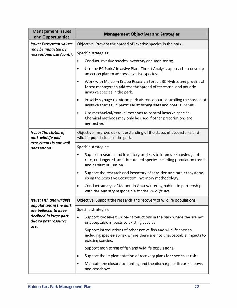
Issue: Ecosystem values may be impacted by recreational use (cont.).
Objective: Prevent the spread of invasive species in the park.
Specific strategies:
Conduct invasive species inventory and monitoring.
Use the BC Parks’ Invasive Plant Threat Analysis approach to develop an action plan to address invasive species.
Work with Malcolm Knapp Research Forest, BC Hydro, and provincial forest managers to address the spread of terrestrial and aquatic invasive species in the park.
Provide signage to inform park visitors about controlling the spread of invasive species, in particular at fishing sites and boat launches.
Use mechanical/manual methods to control invasive species. Chemical methods may only be used if other prescriptions are ineffective.
Issue: The status of park wildlife and ecosystems is not well understood.
Objective: Improve our understanding of the status of ecosystems and wildlife populations in the park.
Specific strategies:
Support research and inventory projects to improve knowledge of rare, endangered, and threatened species including population trends and habitat utilisation.
Support the research and inventory of sensitive and rare ecosystems using the Sensitive Ecosystem Inventory methodology.
Conduct surveys of Mountain Goat wintering habitat in partnership with the Ministry responsible for the Wildlife Act.
Issue: Fish and wildlife populations in the park are believed to have declined in large part due to past resource use.
Objective: Support the research and recovery of wildlife populations.
Specific strategies:
Support Roosevelt Elk re-introductions in the park where the are not unacceptable impacts to existing species
Support introductions of other native fish and wildlife species including species-at-risk where there are not unacceptable impacts to existing species.
Support monitoring of fish and wildlife populations
Support the implementation of recovery plans for species at risk.
Maintain the closure to hunting and the discharge of firearms, bows and crossbows.
Golden Ears Park Management Plan 23
Management Issues and Opportunities
Management Objectives and Strategies
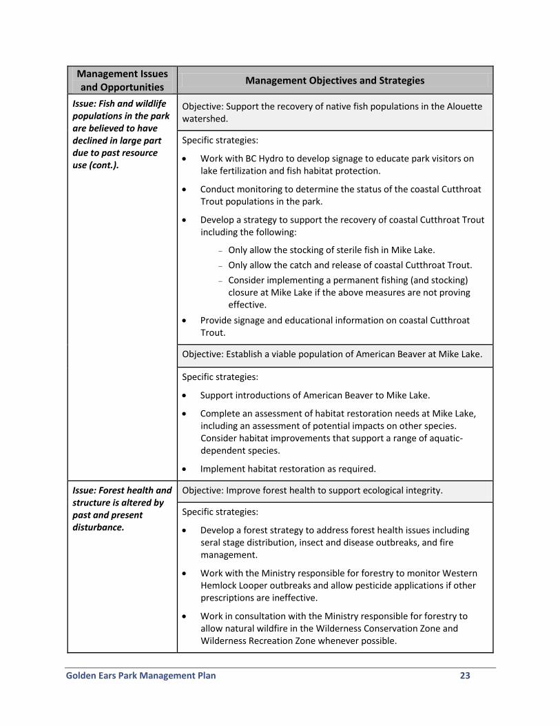
Issue: Fish and wildlife populations in the park are believed to have declined in large part due to past resource use (cont.).
Objective: Support the recovery of native fish populations in the Alouette watershed.
Specific strategies:
Work with BC Hydro to develop signage to educate park visitors on lake fertilization and fish habitat protection.
Conduct monitoring to determine the status of the coastal Cutthroat Trout populations in the park.
Develop a strategy to support the recovery of coastal Cutthroat Trout including the following:
Only allow the stocking of sterile fish in Mike Lake.
Only allow the catch and release of coastal Cutthroat Trout.
Consider implementing a permanent fishing (and stocking) closure at Mike Lake if the above measures are not proving effective.
Provide signage and educational information on coastal Cutthroat Trout.
Objective: Establish a viable population of American Beaver at Mike Lake.
Specific strategies:
Support introductions of American Beaver to Mike Lake.
Complete an assessment of habitat restoration needs at Mike Lake, including an assessment of potential impacts on other species. Consider habitat improvements that support a range of aquatic-dependent species.
Implement habitat restoration as required.
Issue: Forest health and structure is altered by past and present disturbance.
Objective: Improve forest health to support ecological integrity.
Specific strategies:
Develop a forest strategy to address forest health issues including seral stage distribution, insect and disease outbreaks, and fire management.
Work with the Ministry responsible for forestry to monitor Western Hemlock Looper outbreaks and allow pesticide applications if other prescriptions are ineffective.
Work in consultation with the Ministry responsible for forestry to allow natural wildfire in the Wilderness Conservation Zone and Wilderness Recreation Zone whenever possible.
Golden Ears Park Management Plan 24
Management Issues and Opportunities
Management Objectives and Strategies
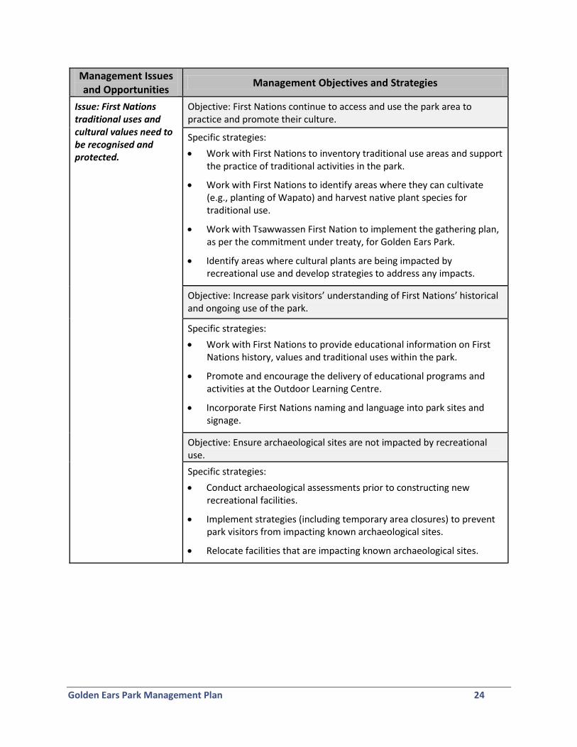
Issue: First Nations traditional uses and cultural values need to be recognised and protected.
Objective: First Nations continue to access and use the park area to practice and promote their culture.
Specific strategies:
Work with First Nations to inventory traditional use areas and support the practice of traditional activities in the park.
Work with First Nations to identify areas where they can cultivate (e.g., planting of Wapato) and harvest native plant species for traditional use.
Work with Tsawwassen First Nation to implement the gathering plan, as per the commitment under treaty, for Golden Ears Park.
Identify areas where cultural plants are being impacted by recreational use and develop strategies to address any impacts.
Objective: Increase park visitors’ understanding of First Nations’ historical and ongoing use of the park.
Specific strategies:
Work with First Nations to provide educational information on First Nations history, values and traditional uses within the park.
Promote and encourage the delivery of educational programs and activities at the Outdoor Learning Centre.
Incorporate First Nations naming and language into park sites and signage.
Objective: Ensure archaeological sites are not impacted by recreational use.
Specific strategies:
Conduct archaeological assessments prior to constructing new recreational facilities.
Implement strategies (including temporary area closures) to prevent park visitors from impacting known archaeological sites.
Relocate facilities that are impacting known archaeological sites.
Golden Ears Park Management Plan 25
Management Issues and Opportunities
Management Objectives and Strategies
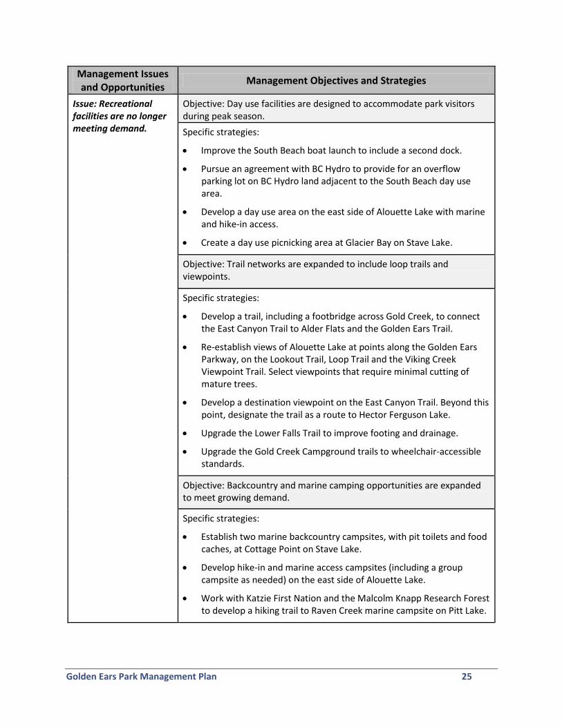
Issue: Recreational facilities are no longer meeting demand.
Objective: Day use facilities are designed to accommodate park visitors during peak season.
Specific strategies:
Improve the South Beach boat launch to include a second dock.
Pursue an agreement with BC Hydro to provide for an overflow parking lot on BC Hydro land adjacent to the South Beach day use area.
Develop a day use area on the east side of Alouette Lake with marine and hike-in access.
Create a day use picnicking area at Glacier Bay on Stave Lake.
Objective: Trail networks are expanded to include loop trails and viewpoints.
Specific strategies:
Develop a trail, including a footbridge across Gold Creek, to connect the East Canyon Trail to Alder Flats and the Golden Ears Trail.
Re-establish views of Alouette Lake at points along the Golden Ears Parkway, on the Lookout Trail, Loop Trail and the Viking Creek Viewpoint Trail. Select viewpoints that require minimal cutting of mature trees.
Develop a destination viewpoint on the East Canyon Trail. Beyond this point, designate the trail as a route to Hector Ferguson Lake.
Upgrade the Lower Falls Trail to improve footing and drainage.
Upgrade the Gold Creek Campground trails to wheelchair-accessible standards.
Objective: Backcountry and marine camping opportunities are expanded to meet growing demand.
Specific strategies:
Establish two marine backcountry campsites, with pit toilets and food caches, at Cottage Point on Stave Lake.
Develop hike-in and marine access campsites (including a group campsite as needed) on the east side of Alouette Lake.
Work with Katzie First Nation and the Malcolm Knapp Research Forest to develop a hiking trail to Raven Creek marine campsite on Pitt Lake.
Golden Ears Park Management Plan 26
Management Issues and Opportunities
Management Objectives and Strategies
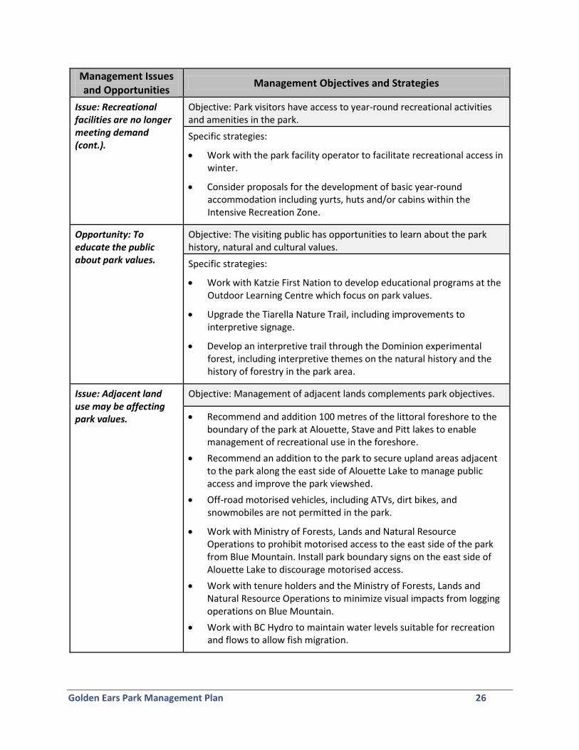
Issue: Recreational facilities are no longer meeting demand (cont.).
Objective: Park visitors have access to year-round recreational activities and amenities in the park.
Specific strategies:
Work with the park facility operator to facilitate recreational access in winter.
Consider proposals for the development of basic year-round accommodation including yurts, huts and/or cabins within the Intensive Recreation Zone.
Opportunity: To educate the public about park values.
Objective: The visiting public has opportunities to learn about the park history, natural and cultural values.
Specific strategies:
Work with Katzie First Nation to develop educational programs at the Outdoor Learning Centre which focus on park values.
Upgrade the Tiarella Nature Trail, including improvements to interpretive signage.
Develop an interpretive trail through the Dominion experimental forest, including interpretive themes on the natural history and the history of forestry in the park area.
Issue: Adjacent land use may be affecting park values.
Objective: Management of adjacent lands complements park objectives.
Recommend and addition 100 metres of the littoral foreshore to the boundary of the park at Alouette, Stave and Pitt lakes to enable management of recreational use in the foreshore.
Recommend an addition to the park to secure upland areas adjacent to the park along the east side of Alouette Lake to manage public access and improve the park viewshed.
Off-road motorised vehicles, including ATVs, dirt bikes, and snowmobiles are not permitted in the park.
Work with Ministry of Forests, Lands and Natural Resource Operations to prohibit motorised access to the east side of the park from Blue Mountain. Install park boundary signs on the east side of Alouette Lake to discourage motorised access.
Work with tenure holders and the Ministry of Forests, Lands and Natural Resource Operations to minimize visual impacts from logging operations on Blue Mountain.
Work with BC Hydro to maintain water levels suitable for recreation and flows to allow fish migration.
Golden Ears Park Management Plan 27
Management Issues and Opportunities
Management Objectives and Strategies
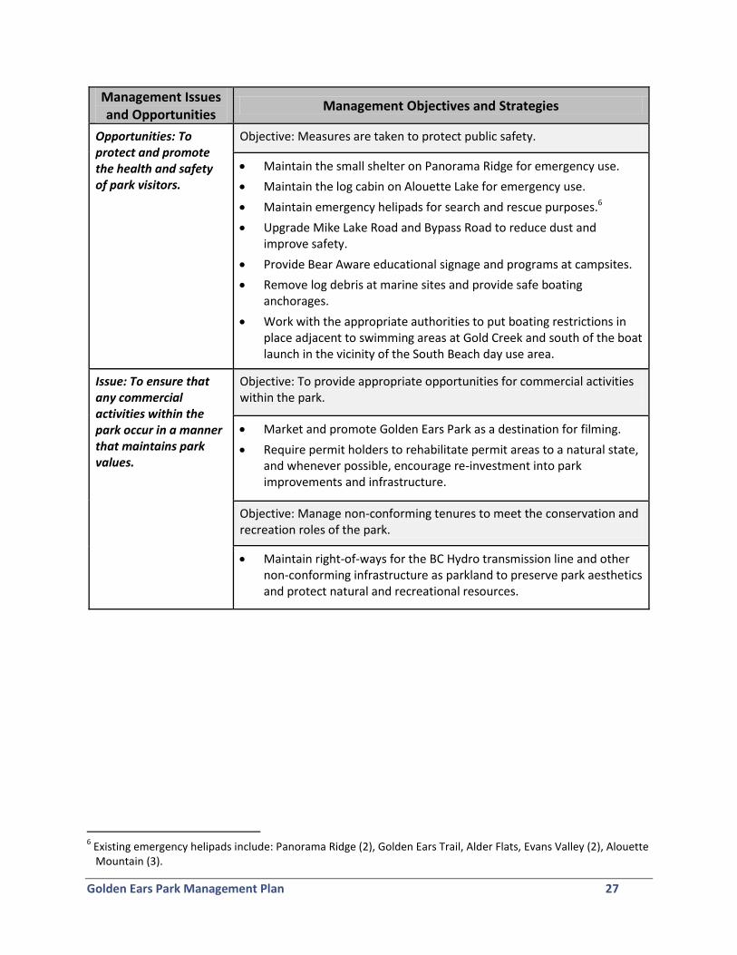
Opportunities: To protect and promote the health and safety of park visitors.
Objective: Measures are taken to protect public safety.
Maintain the small shelter on Panorama Ridge for emergency use.
Maintain the log cabin on Alouette Lake for emergency use.
Maintain emergency helipads for search and rescue purposes.6
Upgrade Mike Lake Road and Bypass Road to reduce dust and improve safety.
Provide Bear Aware educational signage and programs at campsites.
Remove log debris at marine sites and provide safe boating anchorages.
Work with the appropriate authorities to put boating restrictions in place adjacent to swimming areas at Gold Creek and south of the boat launch in the vicinity of the South Beach day use area.
Issue: To ensure that any commercial activities within the park occur in a manner that maintains park values.
Objective: To provide appropriate opportunities for commercial activities within the park.
Market and promote Golden Ears Park as a destination for filming.
Require permit holders to rehabilitate permit areas to a natural state, and whenever possible, encourage re-investment into park improvements and infrastructure.
Objective: Manage non-conforming tenures to meet the conservation and recreation roles of the park.
Maintain right-of-ways for the BC Hydro transmission line and other non-conforming infrastructure as parkland to preserve park aesthetics and protect natural and recreational resources.
6 Existing emergency helipads include: Panorama Ridge (2), Golden Ears Trail, Alder Flats, Evans Valley (2), Alouette Mountain (3).
Golden Ears Park Management Plan 28
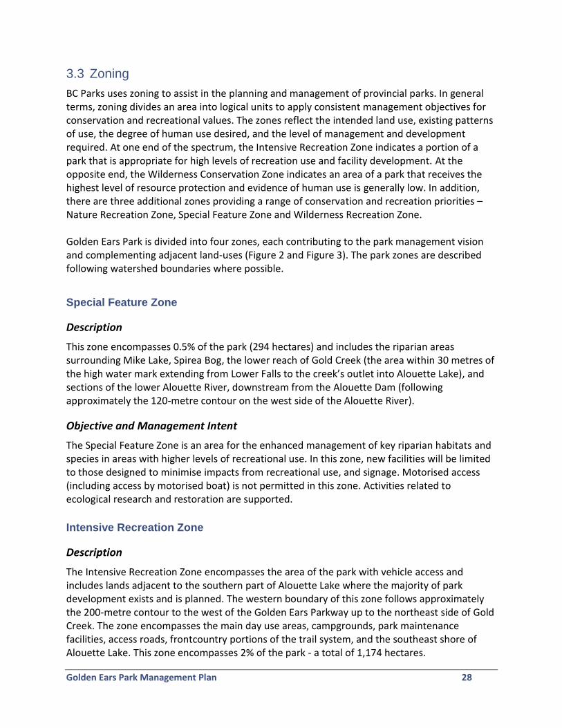
3.3 Zoning
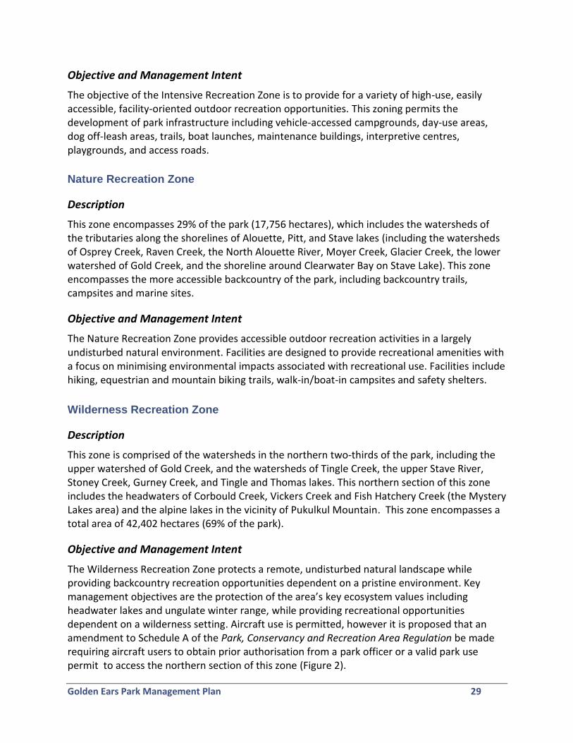
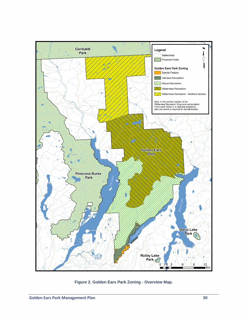
BC Parks uses zoning to assist in the planning and management of provincial parks. In general terms, zoning divides an area into logical units to apply consistent management objectives for conservation and recreational values. The zones reflect the intended land use, existing patterns of use, the degree of human use desired, and the level of management and development required. At one end of the spectrum, the Intensive Recreation Zone indicates a portion of a park that is appropriate for high levels of recreation use and facility development. At the opposite end, the Wilderness Conservation Zone indicates an area of a park that receives the highest level of resource protection and evidence of human use is generally low. In addition, there are three additional zones providing a range of conservation and recreation priorities – Nature Recreation Zone, Special Feature Zone and Wilderness Recreation Zone. Golden Ears Park is divided into four zones, each contributing to the park management vision and complementing adjacent land-uses (Figure 2 and Figure 3). The park zones are described following watershed boundaries where possible.
Special Feature Zone
Description
This zone encompasses 0.5% of the park (294 hectares) and includes the riparian areas surrounding Mike Lake, Spirea Bog, the lower reach of Gold Creek (the area within 30 metres of the high water mark extending from Lower Falls to the creek’s outlet into Alouette Lake), and sections of the lower Alouette River, downstream from the Alouette Dam (following approximately the 120-metre contour on the west side of the Alouette River).
Objective and Management Intent
The Special Feature Zone is an area for the enhanced management of key riparian habitats and species in areas with higher levels of recreational use. In this zone, new facilities will be limited to those designed to minimise impacts from recreational use, and signage. Motorised access (including access by motorised boat) is not permitted in this zone. Activities related to ecological research and restoration are supported.
Intensive Recreation Zone
Description
The Intensive Recreation Zone encompasses the area of the park with vehicle access and includes lands adjacent to the southern part of Alouette Lake where the majority of park development exists and is planned. The western boundary of this zone follows approximately the 200-metre contour to the west of the Golden Ears Parkway up to the northeast side of Gold Creek. The zone encompasses the main day use areas, campgrounds, park maintenance facilities, access roads, frontcountry portions of the trail system, and the southeast shore of Alouette Lake. This zone encompasses 2% of the park - a total of 1,174 hectares.
Golden Ears Park Management Plan 29
Objective and Management Intent
The objective of the Intensive Recreation Zone is to provide for a variety of high-use, easily accessible, facility-oriented outdoor recreation opportunities. This zoning permits the development of park infrastructure including vehicle-accessed campgrounds, day-use areas, dog off-leash areas, trails, boat launches, maintenance buildings, interpretive centres, playgrounds, and access roads.
Nature Recreation Zone
Description
This zone encompasses 29% of the park (17,756 hectares), which includes the watersheds of the tributaries along the shorelines of Alouette, Pitt, and Stave lakes (including the watersheds of Osprey Creek, Raven Creek, the North Alouette River, Moyer Creek, Glacier Creek, the lower watershed of Gold Creek, and the shoreline around Clearwater Bay on Stave Lake). This zone encompasses the more accessible backcountry of the park, including backcountry trails, campsites and marine sites.
Objective and Management Intent
The Nature Recreation Zone provides accessible outdoor recreation activities in a largely undisturbed natural environment. Facilities are designed to provide recreational amenities with a focus on minimising environmental impacts associated with recreational use. Facilities include hiking, equestrian and mountain biking trails, walk-in/boat-in campsites and safety shelters.
Wilderness Recreation Zone
Description
This zone is comprised of the watersheds in the northern two-thirds of the park, including the upper watershed of Gold Creek, and the watersheds of Tingle Creek, the upper Stave River, Stoney Creek, Gurney Creek, and Tingle and Thomas lakes. This northern section of this zone includes the headwaters of Corbould Creek, Vickers Creek and Fish Hatchery Creek (the Mystery Lakes area) and the alpine lakes in the vicinity of Pukulkul Mountain. This zone encompasses a total area of 42,402 hectares (69% of the park).
Objective and Management Intent
The Wilderness Recreation Zone protects a remote, undisturbed natural landscape while providing backcountry recreation opportunities dependent on a pristine environment. Key management objectives are the protection of the area’s key ecosystem values including headwater lakes and ungulate winter range, while providing recreational opportunities dependent on a wilderness setting. Aircraft use is permitted, however it is proposed that an amendment to Schedule A of the Park, Conservancy and Recreation Area Regulation be made requiring aircraft users to obtain prior authorisation from a park officer or a valid park use permit to access the northern section of this zone (Figure 2).
Golden Ears Park Management Plan 30
Figure 2. Golden Ears Park Zoning - Overview Map.
Golden Ears Park Management Plan 31
Figure 3. Golden Ears Park Zoning - Map of Zoning at the Southern End of the Park.
Golden Ears Park Management Plan 32
4.0 References
British Columbia Wildlife Watch. http://www3.bc.sympatico.ca/driftwood/bcwwhome.htm Ebata, Tim (2011). Personal communication. Grass, Al (1989). Golden Ears Provincial Park Bird Checklist. Unpublished report. Katzie First Nation (2011). Park Management Plan for Foreshore and Riparian Zones of Alouette Lake in Golden Ears Provincial Park. Prepared for BC Parks. 23 pp. Katzie First Nation (2002). http://www.katzie.ca/katzie_history_part_1.htm Reynolds, Darryl. (2011) Personal communication. Warttig, Warren amd Inselberg, Alex (2010). BC’s Coast Region: Species and Ecosystems of Conservation. Prepared for the South Coast Conservation Program, 2pp.
Golden Ears Park Management Plan 33
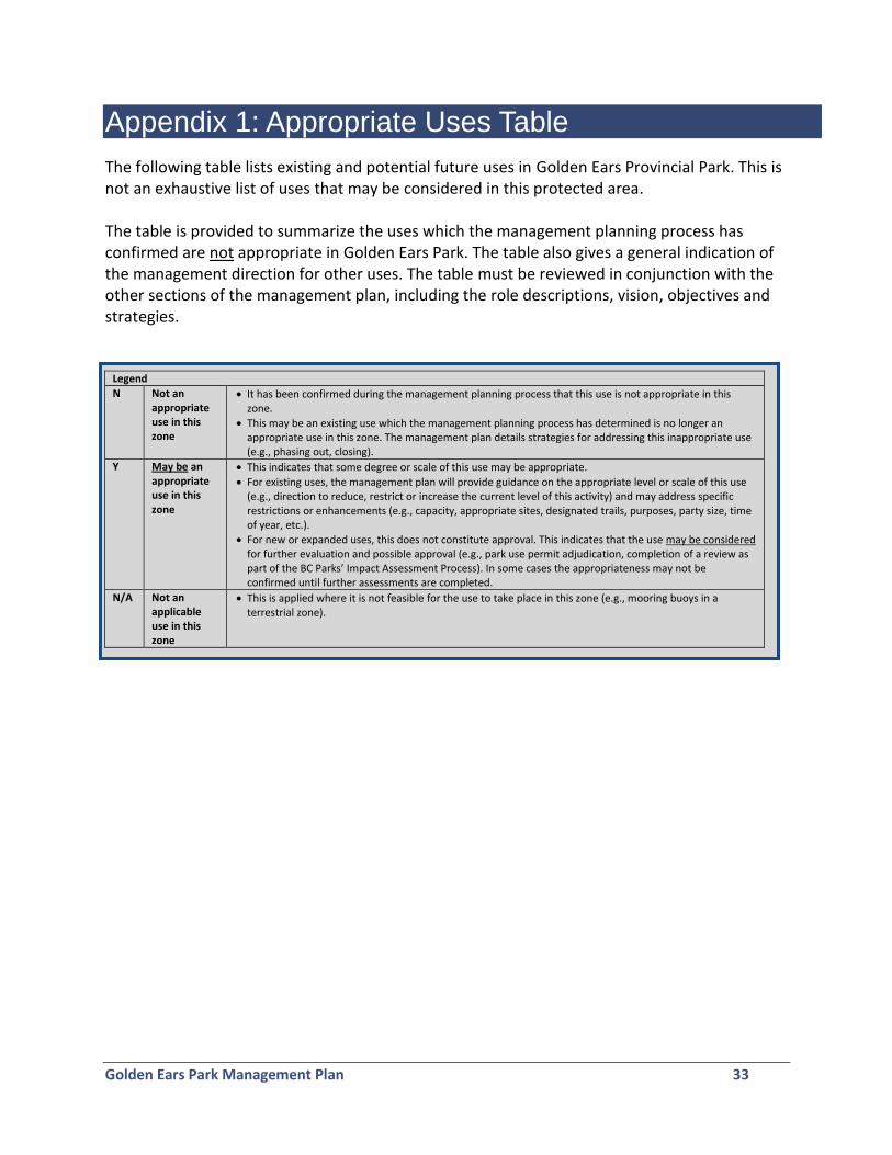
Appendix 1: Appropriate Uses Table
The following table lists existing and potential future uses in Golden Ears Provincial Park. This is not an exhaustive list of uses that may be considered in this protected area. The table is provided to summarize the uses which the management planning process has confirmed are not appropriate in Golden Ears Park. The table also gives a general indication of the management direction for other uses. The table must be reviewed in conjunction with the other sections of the management plan, including the role descriptions, vision, objectives and strategies.
Legend
N Not an appropriate use in this zone
It has been confirmed during the management planning process that this use is not appropriate in this zone.
This may be an existing use which the management planning process has determined is no longer an appropriate use in this zone. The management plan details strategies for addressing this inappropriate use (e.g., phasing out, closing).
Y May be an appropriate use in this zone
This indicates that some degree or scale of this use may be appropriate.
For existing uses, the management plan will provide guidance on the appropriate level or scale of this use (e.g., direction to reduce, restrict or increase the current level of this activity) and may address specific restrictions or enhancements (e.g., capacity, appropriate sites, designated trails, purposes, party size, time of year, etc.).
For new or expanded uses, this does not constitute approval. This indicates that the use may be considered for further evaluation and possible approval (e.g., park use permit adjudication, completion of a review as part of the BC Parks’ Impact Assessment Process). In some cases the appropriateness may not be confirmed until further assessments are completed.
N/A Not an applicable use in this zone
This is applied where it is not feasible for the use to take place in this zone (e.g., mooring buoys in a terrestrial zone).
Golden Ears Park Management Plan 34
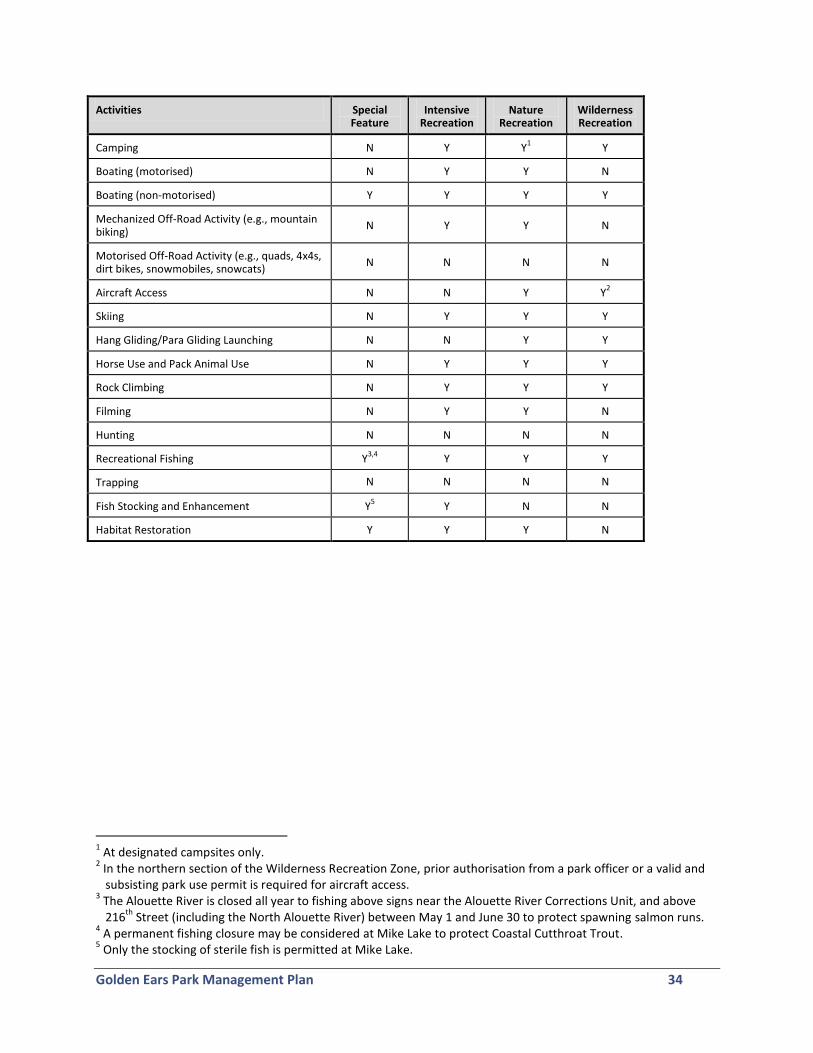
Activities Special Feature
Intensive Recreation
Nature Recreation
Wilderness Recreation
Camping N Y Y1 Y
Boating (motorised) N Y Y N
Boating (non-motorised) Y Y Y Y
Mechanized Off-Road Activity (e.g., mountain biking)
N Y Y N
Motorised Off-Road Activity (e.g., quads, 4x4s, dirt bikes, snowmobiles, snowcats)
N N N N
Aircraft Access N N Y Y2
Skiing N Y Y Y
Hang Gliding/Para Gliding Launching N N Y Y
Horse Use and Pack Animal Use N Y Y Y
Rock Climbing N Y Y Y
Filming N Y Y N
Hunting N N N N
Recreational Fishing Y3,4
Y Y Y
Trapping N N N N
Fish Stocking and Enhancement Y5 Y N N
Habitat Restoration Y Y Y N
1 At designated campsites only.
2 In the northern section of the Wilderness Recreation Zone, prior authorisation from a park officer or a valid and subsisting park use permit is required for aircraft access.
3 The Alouette River is closed all year to fishing above signs near the Alouette River Corrections Unit, and above 216
th Street (including the North Alouette River) between May 1 and June 30 to protect spawning salmon runs.
4 A permanent fishing closure may be considered at Mike Lake to protect Coastal Cutthroat Trout.
5 Only the stocking of sterile fish is permitted at Mike Lake.
Golden Ears Park Management Plan 35
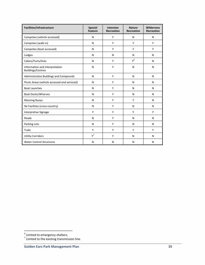
Facilities/Infrastructure Special Feature
Intensive Recreation
Nature Recreation
Wilderness Recreation
Campsites (vehicle accessed) N Y N N
Campsites (walk-in) N Y Y Y
Campsites (boat accessed) N Y Y Y
Lodges N N N N
Cabins/Yurts/Huts N Y Y6 N
Information and Interpretation Buildings/Centres
N Y N N
Administrative Buildings and Compounds N Y N N
Picnic Areas (vehicle accessed and serviced) N Y N N
Boat Launches N Y N N
Boat Docks/Wharves N Y N N
Mooring Buoys N Y Y N
Ski Facilities (cross-country) N Y N N
Interpretive Signage Y Y Y Y
Roads N Y N N
Parking Lots N Y N N
Trails Y Y Y Y
Utility Corridors Y7 Y N N
Water Control Structures N N N N
6 Limited to emergency shelters.
7 Limited to the existing transmission line.
Golden Ears Park Management Plan 36
Appendix 2: List of Golden Ears Park Trails
Interpretive Trails:
1. Spirea Nature Trail: Staged from the Spirea Nature Trail parking lot, this is a loop trail designed to accommodate people with a variety of physical abilities. The purpose of the trail and boardwalks is to interpret coastal bog flora and fauna and the ecology and history of the area. The main trail is 540 metres; there is also a shorter loop trail of 350 metres.
2. Tiarella Nature Trail: Accessed from the Alouette Campground, the purpose of this trail is to provide a short, pleasant walk through coastal forest.
3. Trail of the Fallen Giants: The purpose of the trail is to interpret the forest ecology and the logging history of the area. The trail is hiking only and takes approximately 15 minutes.
Trails:
1. Mike Lake Trail: The purpose of this trail is to provide a link from the Main Corral at the park entrance to the Alouette Valley Trail, Mike Lake, and trails to Alouette Mountain. This trail is designed for both horses and hikers, with an elevation change of 100 metres and a distance of 4.2 kilometres. Suggested hiking time is 2 hours.
2. Lakeside Trail: This 1.2 kilometre trail loops around Mike Lake and is a popular route for hikers and joggers. A section of this trail travels outside the park and through the UBC Research Forest.
3. Incline Trail: The purpose of this steep trail is to provide a direct route from Mike Lake to the Fire Access Trail and to access remnants of the logging era. The trail follows the incline that was once used by loggers as a route to skyline logs down to Mike Lake from the railhead above; an abandoned steam donkey sled can be seen after crossing Mike Creek. The trail has an elevation gain of 150 metres over 1.2 kilometres and is a horse and hiking trail.
4. Eric Dunning Trail and Switch Back Trail: The purpose of these two trails is to provide a short cut for both hikers and mountain bikers from the Mike Lake Road to the Alouette Mountain Fire Access Trail. The trail is approximately 1.7 kilometres.
5. Alouette Mountain Fire Access Trail: This trail follows from Incline Trail through subalpine forest . The purpose of this trail is to provide access to a granite knoll on Alouette Mountain and an area that reflects the parks’ natural history – an area of forest disturb by a blow-down caused by Typhoon Freda in 1962. This multipurpose trail is for horses, hikers, and bikers, and has a 550 metres elevation change over 8 kilometres.
6. Alouette Mountain Hiking Trail: This hiking-only trail begins off the Alouette Mountain Fire Access Trail. Its purpose is to provide access to the summit of Alouette Mountain. This trail also has many highlights including the virgin stands of mountain hemlock and yellow cedar and the spectacular panoramic view from Alouette Mountain. The trail is a
Golden Ears Park Management Plan 37
strenuous hike with an elevation change of 600 metres over 4.2 kilometres. Experience and proper equipment is advised.
7. Alouette Valley Trail: The purpose of this trail is to connect the Mike Lake Trail to the Menzies Trail and to provide access for horseback riders to the eastern portions of the park. This trail winds for 9.7 kilometres along the eastern side of the parkway with very little elevation change. Suggested hiking time is 3.5 hours.
8. Menzies Trail: The purpose of this 9.7 kilometre multipurpose trail is to link trails near Park Headquarters to the trails accessed by the Gold Creek Parking Lot. Suggested hiking time is 4.5 hours.
9. Lookout and Loop Trails: The purpose of these trails is to provide a short pleasant hike to a lookout and to return via another trail. Beginning near the Spirea Nature Trail, the Lookout Trail is a hiking only trail and the Loop Trail is open to horses and hikers. The total length is 2.5 kilometres with an elevation change of 75 metres. Parking is available at the Spirea parking lot.
10. Viewpoint Trail: The purpose of this hiking trail from the West Canyon Parking Lot is to provide a short, easy hike with access to two spectacular viewpoints along a total length of 2 kilometres. Lake Viewpoint and Viking Creek Viewpoint both offer good views, and in wetter seasons a picturesque waterfall tumbles down a cliff just beyond Lake Viewpoint.
11. West Canyon Trail (Golden Ears Trail): The purpose of this 5.7 kilometres hiking only trail is to provide access to Alder Flats where the Golden Ears Trail continues to the summit of the north peak of Golden Ears. From the West Canyon Parking Lot this trail follows an old logging grade for 3.1 kilometres and then turns uphill. At this point a short trail to Lower Falls branches from the trail.
12. Golden Ears Trail: This trail offers a strenuous and difficult hike to the summit of Golden Ears’ north peak. Beginning at Alder Flats, the trail switchbacks on an old logging road and then heads steeply uphill to East Ridge and then Panorama Ridge, where there are impressive views of the Lower Mainland. The emergency shelter is located at 10.7 kilometres. Total length of the trail from the parking lot is 12 kilometres with a change in elevation of 1,500 metres.
13. Lower Falls Trail: The purpose of this popular walking trail is to access the Lower Falls and some of the best scenery in the park. Starting at the Gold Creek Parking Lot and following the eastern bank of Gold Creek, a beach area halfway to the Falls is a good spot for a picnic or a sunbathe. The total length of this trail is 2.7 kilometres.
14. East Canyon Trail: The purpose of this 4.5 kilometres trail is to provide access to Gold Creek for horses, hikers and cyclists. The trail leads to spectacular scenery, particularly at Viewpoint Beach where Golden Ears and Edge Peak can be viewed to the west. The trail narrows and continues parallel to Gold Creek for another 7 kilometres.