Embed Size (px)
Citation preview
Draft
GOLDEN STATE BOULEVARD/GOLF ROAD/ BERKELEY AVENUE INTERSECTION PROJECT
Initial Study / Mitigated Negative Declaration
August 2018
Draft
GOLDEN STATE BOULEVARD/GOLF ROAD/ BERKELEY AVENUE INTERSECTION PROJECT
Initial Study / Mitigated Negative Declaration
Stanislaus County, California
August 2018
Submitted to:
Stanislaus County Public Works Department
1716 Morgan Road Modesto, CA 95358
Prepared by:
Drake Haglan and Associates, Inc. 11060 White Rock Road, Suite 200
Rancho Cordova, CA 95670 916.363.4210
Golden State Boulevard/Golf Road/Berkeley Avenue Intersection Project Page i Initial Study/Mitigated Negative Declaration Drake Haglan & Associates August 2018
EXECUTIVE SUMMARY The County of Stanislaus (County) proposes to construct operational improvements at the Golden State Boulevard/Golf Road/Berkeley Avenue Intersections (Project). The Project site is located just south of the City of Turlock in the southern portion of the County. Land use surrounding the Project site consists of agricultural lands with adjacent open space uses. Adjacent land uses include agricultural, commercial, industrial, and urban transitional uses. The purpose of the Project is to improve regional air quality by reducing emissions and alleviating congestion. This would be achieved by redesigning the intersections to upgrade their current operational Level of Service (LOS) and reducing idling time for automobile traffic. The current LOS at these intersections is a LOS F, which is greater than 80 seconds of delay. County standards call for a LOS of C or better (20-35 seconds of delay). The proposed improvements would provide for LOS of C and would reduce delay to 27 to 30 seconds by year 2030. This Draft Initial Study/Mitigated Negative Declaration (IS/MND) was submitted to the State Clearinghouse on 08/30/2018, for a 30-day public review period that will end on мл/лн/2018. During the public review period, the Draft IS/MND is available for review at the County Department of Public Works (1716 Morgan Road. Modesto) during business hours. This IS/MND was prepared for the Project to assess the potential effects on the environment and the significance of those effects. Based on the results of the IS/MND, the Project would not have any significant effects on the environment once mitigation measures are implemented. This conclusion is supported by the following findings:
• The Project would not affect agricultural and forest resources, mineral resources, or tribal cultural resources.
• The Project would have a less than significant effect on aesthetics, air quality, cultural resources, geology and soils, greenhouse gas emissions, energy, hydrology and water quality, land use and land use planning, noise, population and housing, recreation, and utilities and services.
• The Project would have a less-than significant effect, once mitigation measures are implemented, on biological resources, hazards and hazardous materials, public services, and transportation and traffic.
• No substantial evidence exists that the Project would have a significant negative or adverse effect on the environment.
• The Project incorporates standard construction measures, as described in the IS/MND, and all applicable mitigation measures as listed below and described in the IS.
In addition to standard construction measures required by Caltrans Standard Specifications and other applicable laws, regulations, and policies, the following mitigation measures will be implemented as part of the Project to avoid or minimize potential environmental impacts. Implementation of these mitigation measures would reduce the potentially significant environmental impacts of the proposed Project to a less than significant level.
Golden State Boulevard/Golf Road/Berkeley Avenue Intersection Project Page ii Initial Study/Mitigated Negative Declaration Drake Haglan & Associates August 2018
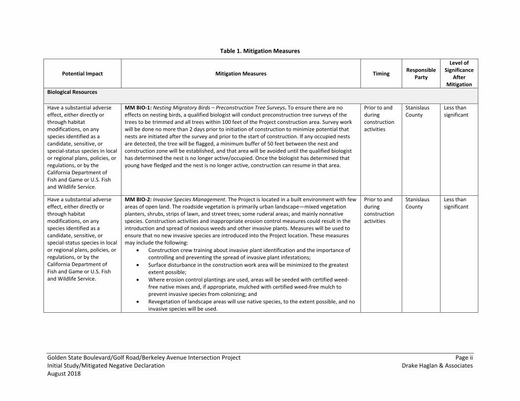
Table 1. Mitigation Measures
Potential Impact Mitigation Measures Timing Responsible Party
Level of Significance
After Mitigation
Biological Resources
Have a substantial adverse effect, either directly or through habitat modifications, on any species identified as a candidate, sensitive, or special-status species in local or regional plans, policies, or regulations, or by the California Department of Fish and Game or U.S. Fish and Wildlife Service.
MM BIO-1: Nesting Migratory Birds – Preconstruction Tree Surveys. To ensure there are no effects on nesting birds, a qualified biologist will conduct preconstruction tree surveys of the trees to be trimmed and all trees within 100 feet of the Project construction area. Survey work will be done no more than 2 days prior to initiation of construction to minimize potential that nests are initiated after the survey and prior to the start of construction. If any occupied nests are detected, the tree will be flagged, a minimum buffer of 50 feet between the nest and construction zone will be established, and that area will be avoided until the qualified biologist has determined the nest is no longer active/occupied. Once the biologist has determined that young have fledged and the nest is no longer active, construction can resume in that area.
Prior to and during construction activities
Stanislaus County
Less than significant
Have a substantial adverse effect, either directly or through habitat modifications, on any species identified as a candidate, sensitive, or special-status species in local or regional plans, policies, or regulations, or by the California Department of Fish and Game or U.S. Fish and Wildlife Service.
MM BIO-2: Invasive Species Management. The Project is located in a built environment with few areas of open land. The roadside vegetation is primarily urban landscape—mixed vegetation planters, shrubs, strips of lawn, and street trees; some ruderal areas; and mainly nonnative species. Construction activities and inappropriate erosion control measures could result in the introduction and spread of noxious weeds and other invasive plants. Measures will be used to ensure that no new invasive species are introduced into the Project location. These measures may include the following:
• Construction crew training about invasive plant identification and the importance of controlling and preventing the spread of invasive plant infestations;
• Surface disturbance in the construction work area will be minimized to the greatest extent possible;
• Where erosion control plantings are used, areas will be seeded with certified weed-free native mixes and, if appropriate, mulched with certified weed-free mulch to prevent invasive species from colonizing; and
• Revegetation of landscape areas will use native species, to the extent possible, and no invasive species will be used.
Prior to and during construction activities
Stanislaus County
Less than significant
Golden State Boulevard/Golf Road/Berkeley Avenue Intersection Project Page iii Initial Study/Mitigated Negative Declaration Drake Haglan & Associates August 2018
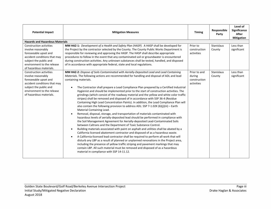
Potential Impact Mitigation Measures Timing Responsible Party
Level of Significance
After Mitigation
Hazards and Hazardous Materials Construction activities involve reasonably foreseeable upset and accident conditions that may subject the public and environment to the release of hazardous materials.
MM HAZ-1: Development of a Health and Safety Plan (HASP). A HASP shall be developed for the Project by the contractor selected by the County. The County Public Works Department is responsible for reviewing and approving the HASP. The HASP shall describe appropriate procedures to follow in the event that any contaminated soil or groundwater is encountered during construction activities. Any unknown substances shall be tested, handled, and disposed of in accordance with appropriate federal, state and local regulations.
Prior to construction activities
Stanislaus County
Less than significant
Construction activities involve reasonably foreseeable upset and accident conditions that may subject the public and environment to the release of hazardous materials.
MM HAZ-2: Dispose of Soils Contaminated with Aerially-Deposited Lead and Lead Containing Materials. The following actions are recommended for handling and disposal of ADL and lead containing materials.
• The Contractor shall prepare a Lead Compliance Plan prepared by a Certified Industrial Hygienist and should be implemented prior to the start of construction activities. The grindings (which consist of the roadway material and the yellow and white color traffic stripes) shall be removed and disposed of in accordance with SSP 36-4 (Residue Containing High Lead Concentration Paints). In addition, the Lead Compliance Plan will also contain the following provision to address ADL: SSP 7-1.02K (6)(j)(iii) – Earth Material Containing Lead.
• Removal, disposal, storage, and transportation of materials contaminated with hazardous levels of aerially-deposited lead should be performed in compliance with the Soil Management Agreement for Aerially-deposited Lead-Contaminated Soils between Caltrans and the Department of Toxic Substance Control.
• Building materials associated with paint on asphalt and utilities shall be abated by a California licensed abatement contractor and disposed of as a hazardous waste.
• A California-licensed lead contractor shall be required to perform all work that will disturb any LBP as a result of planned or unplanned renovations in the Project area, including the presence of yellow traffic striping and pavement markings that may contain LBP. All such material must be removed and disposed of as a hazardous material in compliance with SSP 14-11.12.
Prior to and during construction activities
Stanislaus County
Less than significant
Golden State Boulevard/Golf Road/Berkeley Avenue Intersection Project Page iv Initial Study/Mitigated Negative Declaration Drake Haglan & Associates August 2018
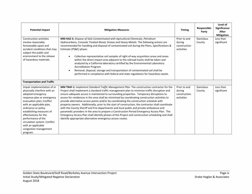
Potential Impact Mitigation Measures Timing Responsible Party
Level of Significance
After Mitigation
Construction activities involve reasonably foreseeable upset and accident conditions that may subject the public and environment to the release of hazardous materials.
MM HAZ-3: Dispose of Soils Contaminated with Agricultural Chemicals, Petroleum Hydrocarbons, Creosote Treated Wood, Grease and Heavy Metals. The following actions are recommended for handling and disposal of contaminated soil during the Plans, Specifications & Estimate (PS&E) phase:
• Collective representative soil samples of right-of-way acquisition areas and areas within the direct impact area adjacent to the railroad tracks shall be taken and analyzed by a California laboratory certified by the Environmental Laboratory Accreditation Program.
• Removal, disposal, storage and transportation of contaminated soil shall be performed in compliance with federal and state regulations for hazardous waste.
Prior to and during construction activities
Stanislaus County
Less than significant
Transportation and Traffic
Impair implementation of or physically interfere with an adopted emergency response plan or emergency evacuation plan; Conflict with an applicable plan, ordinance or policy establishing measures of effectiveness for the performance of the circulation system; Conflict with an applicable congestion management program.
MM TRAF-1: Implement Standard Traffic Management Plan. The construction contractor for the Project shall implement a standard traffic management plan to minimize traffic disruption and ensure adequate access is maintained to surrounding properties. Temporary disruptions to access for residences in the area shall be minimized by coordinating construction activities to provide alternative access points and/or by coordinating the construction schedule with property owners. Additionally, prior to the start of construction, the contractor shall coordinate with the County Sheriff and Fire departments and local public and private ambulance and paramedic providers in the area to prepare a Construction Period Emergency Access Plan. The Emergency Access Plan shall identify phases of the Project and construction scheduling and shall identify appropriate alternative emergency access routes.
Prior to and during construction activities
Stanislaus County
Less than significant
ion Measures
Golden State Boulevard/Golf Road/Berkeley Avenue Intersection Project Page v Initial Study/Mitigated Negative Declaration Drake Haglan & Associates August 2018
ACRONYMS AND ABBREVIATIONS The following is a list of abbreviations used within this document. Each term is defined in full once within the document before the abbreviation is used. AASHTO: American Association of State Highway and Transportation Officials
General Plan: Stanislaus County General Plan 2015
AB 32: Assembly Bill 32 H2S: hydrogen sulfide
AB 52: Assembly Bill 52 HASP: Health and Safety Plan
ACM: (presumed) asbestos-containing material HBP: Highway Bridge Program
APN: Accessor Parcel Number IPaC: Information for Planning and Consultation
ARB: California Air Resources Board ISA: Initial Site Assessment
BMP: best management practices IS/MND: Initial Study/Mitigation Negative Declaration
CAAQS: California Ambient Air Quality Standards LBP: lead-based paint
Caltrans: California Department of Transportation MBTA: Migratory Bird Treaty Act
CDC: California Department of Conservation MLD: most likely descendant
CDFG: California Department of Fish and Game MMRP: Mitigation, Monitoring, and Reporting Program
CDFW: California Department of Fish and Wildlife MRZ-1: mineral resources zone (type) 1
CESA: California Endangered Species Act MRZ-3: mineral resources zone (type) 3
CEQA: California Environmental Quality Act MSL: mean sea level
CFGC: California Fish and Game Code NAAQS: National Ambient Air Quality Standards
CHRIS: California Historical Resources Information System
NAHC: Native American Heritage Commission
CNDDB: California Natural Diversity Database NESHAP: national emissions standard for hazardous pollutants
CNEL: community-equivalent noise level NHPA: National Historic Preservation Act
CNPS: California Native Plants Society NO2: nitrogen dioxide
CO: carbon monoxide NPDES: National Pollution Discharge Elimination System
CRHR: California Register of Historic Places NRHP: National Register of Historic Places
dB: decibel O3: ozone
dBA: A-weighted decibel OHE: overhead electrical lines
DWR: California Department of Water Resources OHTC: overhead telephone and communication lines
FEMA: Federal Emergency Management Agency OSHA: Occupational Safety and Health Administration
FHWA: Federal Highway Administration Pb: lead
FTA: Federal Transit Administration PM2.5: particulate matter less than 2.5 microns in diameter
PM10: particulate matter less than 10 microns in
Golden State Boulevard/Golf Road/Berkeley Avenue Intersection Project Page vi Initial Study/Mitigated Negative Declaration Drake Haglan & Associates August 2018
diameter
Project: Golden State/Golf/Berkeley Intersection Project
REC: recognized environmental conditions
ROG: reactive organic gas
RWQCB: Regional Water Quality Control Board
SMARA: California Surface Mining and Reclamation Act
SO2: sulfur dioxide
SWPPP: Stormwater Pollution Prevention Plan
UCMP: University of California Museum of Paleontology
USDA: U.S. Department of Agriculture
U.S. EPA: U.S. Environmental Protection Agency
USGS: U.S. Geological Survey
VdB: root mean square vibration velocity level in decibels
Zoning Code: Stanislaus County Zoning Ordinance
Golden State Boulevard/Golf Road/Berkeley Avenue Intersection Project Page vii Initial Study/Mitigated Negative Declaration Drake Haglan & Associates August 2018
TABLE OF CONTENTS EXECUTIVE SUMMARY .................................................................................................................................................... I
ACRONYMS AND ABBREVIATIONS ................................................................................................................................ V
TABLE OF CONTENTS .................................................................................................................................................. VII
INITIAL STUDY ................................................................................................................................................................ 1
1 INTRODUCTION ..................................................................................................................................................... 1
2 PROJECT DESCRIPTION .......................................................................................................................................... 4
2.1 PROJECT PURPOSE AND NEED .............................................................................................................................. 4 2.2 PROJECT DESCRIPTION ....................................................................................................................................... 4 2.3 CONSTRUCTION ACTIVITIES ................................................................................................................................. 6 2.4 PERMITS AND APPROVALS NEEDED ....................................................................................................................... 7
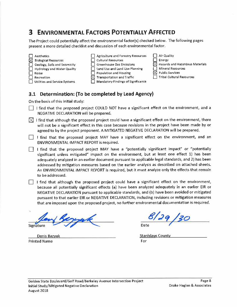
3 ENVIRONMENTAL FACTORS POTENTIALLY AFFECTED .......................................................................................... 8
3.1 DETERMINATION: (TO BE COMPLETED BY LEAD AGENCY) .......................................................................................... 8
4 ENVIRONMENTAL CHECKLIST ............................................................................................................................... 9
4.1 AESTHETICS ...................................................................................................................................................... 9 4.2 AGRICULTURAL AND FOREST RESOURCES ............................................................................................................. 11 4.3 AIR QUALITY .................................................................................................................................................. 13 4.4 BIOLOGICAL RESOURCES ................................................................................................................................... 19 4.5 CULTURAL RESOURCES ..................................................................................................................................... 23 4.6 GEOLOGY, SOILS, AND SEISMICITY ...................................................................................................................... 25 4.7 GREENHOUSE GAS EMISSIONS ........................................................................................................................... 28 4.8 ENERGY ......................................................................................................................................................... 30 4.9 HAZARDS AND HAZARDOUS MATERIALS .............................................................................................................. 31 4.10 HYDROLOGY AND WATER QUALITY ..................................................................................................................... 38 4.11 LAND USE AND LAND USE PLANNING .................................................................................................................. 42 4.12 MINERAL RESOURCES ...................................................................................................................................... 44 4.13 NOISE ........................................................................................................................................................... 45 4.14 POPULATION AND HOUSING .............................................................................................................................. 51 4.15 PUBLIC SERVICES ............................................................................................................................................. 52 4.16 RECREATION .................................................................................................................................................. 54 4.17 TRANSPORTATION AND TRAFFIC ......................................................................................................................... 55 4.18 TRIBAL CULTURAL RESOURCES ........................................................................................................................... 58 4.19 UTILITIES AND SERVICE SYSTEMS ........................................................................................................................ 59 4.20 MANDATORY FINDINGS OF SIGNIFICANCE ............................................................................................................ 61
5 LIST OF PREPARERS AND REVIEWERS ................................................................................................................. 62
6 REFERENCES ........................................................................................................................................................ 63
LIST OF FIGURES
Figure 1. Project Vicinity Map ...................................................................................................................... 2 Figure 2. Project Location Map .................................................................................................................... 3 Figure 3. Proposed Project Design ................................................................................................................ 5
Golden State Boulevard/Golf Road/Berkeley Avenue Intersection Project Page viii Initial Study/Mitigated Negative Declaration Drake Haglan & Associates August 2018
LIST OF TABLES
Table 1. Mitigation Measures ....................................................................................................................... ii Table 2. Construction Equipment ................................................................................................................. 7 Table 3. Project Permits and Approvals ........................................................................................................ 7 Table 4. National Ambient Air Quality Standards ....................................................................................... 14 Table 5. California Ambient Air Quality Standards ..................................................................................... 15 Table 6. Soil Types ....................................................................................................................................... 26 Table 7. Summary of Significant Regulatory Database Search Findings ..................................................... 34 Table 8. Typical Noise Levels ....................................................................................................................... 46 Table 9. Typical Construction Noise Levels ................................................................................................. 48 Table 10. Typical Noise Levels from Construction Equipment ................................................................... 49
Golden State Boulevard/Golf Road/Berkeley Avenue Intersection Project Page 1 Initial Study/Mitigated Negative Declaration Drake Haglan & Associates August 2018
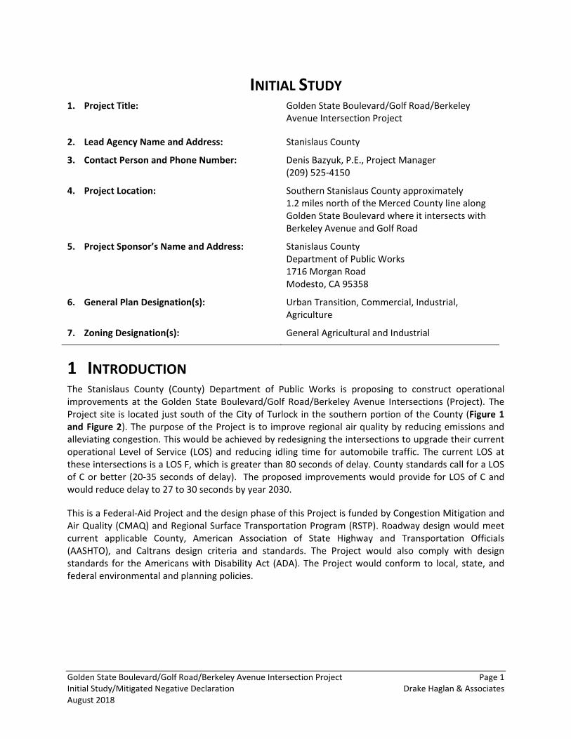
INITIAL STUDY 1. Project Title:
Golden State Boulevard/Golf Road/Berkeley Avenue Intersection Project
2. Lead Agency Name and Address: Stanislaus County
3. Contact Person and Phone Number: Denis Bazyuk, P.E., Project Manager (209) 525-4150
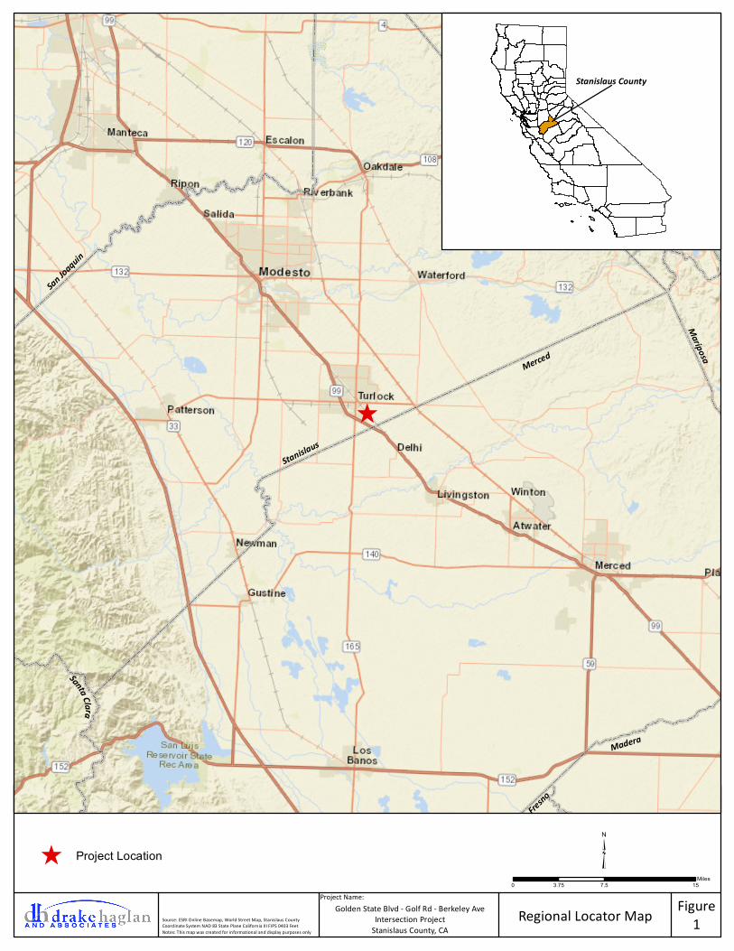
4. Project Location:
Southern Stanislaus County approximately 1.2 miles north of the Merced County line along Golden State Boulevard where it intersects with Berkeley Avenue and Golf Road
5. Project Sponsor’s Name and Address:
Stanislaus County Department of Public Works 1716 Morgan Road Modesto, CA 95358
6. General Plan Designation(s): Urban Transition, Commercial, Industrial, Agriculture
7. Zoning Designation(s): General Agricultural and Industrial
1 INTRODUCTION The Stanislaus County (County) Department of Public Works is proposing to construct operational improvements at the Golden State Boulevard/Golf Road/Berkeley Avenue Intersections (Project). The Project site is located just south of the City of Turlock in the southern portion of the County (Figure 1 and Figure 2). The purpose of the Project is to improve regional air quality by reducing emissions and alleviating congestion. This would be achieved by redesigning the intersections to upgrade their current operational Level of Service (LOS) and reducing idling time for automobile traffic. The current LOS at these intersections is a LOS F, which is greater than 80 seconds of delay. County standards call for a LOS of C or better (20-35 seconds of delay). The proposed improvements would provide for LOS of C and would reduce delay to 27 to 30 seconds by year 2030.
This is a Federal-Aid Project and the design phase of this Project is funded by Congestion Mitigation and Air Quality (CMAQ) and Regional Surface Transportation Program (RSTP). Roadway design would meet current applicable County, American Association of State Highway and Transportation Officials (AASHTO), and Caltrans design criteria and standards. The Project would also comply with design standards for the Americans with Disability Act (ADA). The Project would conform to local, state, and federal environmental and planning policies.
^
Figure1Regional Locator Map
Project Name:Golden State Blvd - Golf Rd - Berkeley Ave
Intersection ProjectStanislaus County, CA
Source: ESRI Online Basemap, World Street Map, Stanislaus CountyCoordinate System NAD 83 State Plane California III FIPS 0403 FeetNotes: This map was created for informational and display purposes only
0 7.5 153.75Miles
^ Project Location ³
San Joaquin
Stanislaus
Merced
Mariposa
Madera
Fresno
Santa Cla ra
Stanislaus County
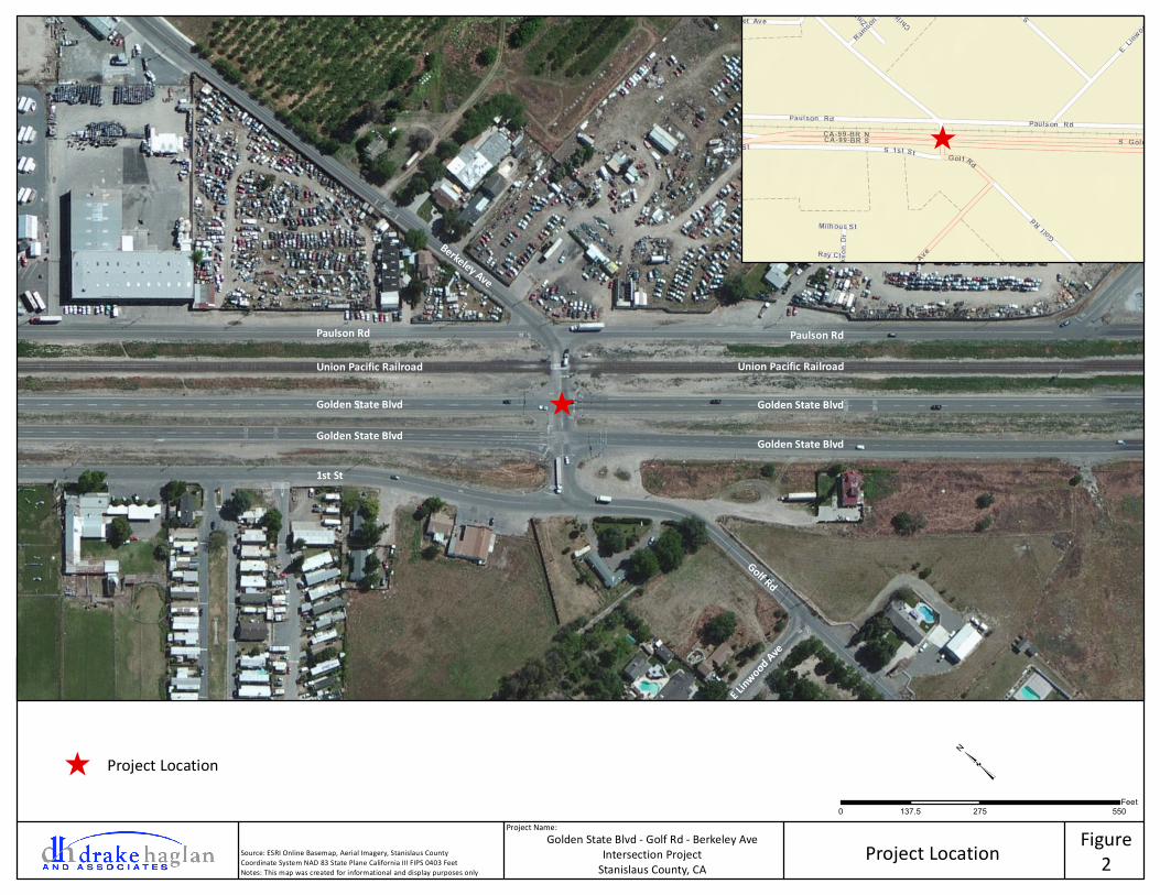
Figure2Project Location
Project Name:Golden State Blvd - Golf Rd - Berkeley Ave
Intersection ProjectStanislaus County, CA
Source: ESRI Online Basemap, Aerial Imagery, Stanislaus CountyCoordinate System NAD 83 State Plane California III FIPS 0403 FeetNotes: This map was created for informational and display purposes only
0 275 550137.5Feet
³
^
Berkeley Ave
Golf Rd
E Linwood Ave
Paulson Rd
Union Pacific Railroad
Golden State Blvd
Golden State Blvd
1st St
^
Paulson Rd
Union Pacific Railroad
Golden State Blvd
Golden State Blvd
^ Project Location
Golden State Boulevard/Golf Road/Berkeley Avenue Intersection Project Page 4 Initial Study/Mitigated Negative Declaration Drake Haglan & Associates August 2018
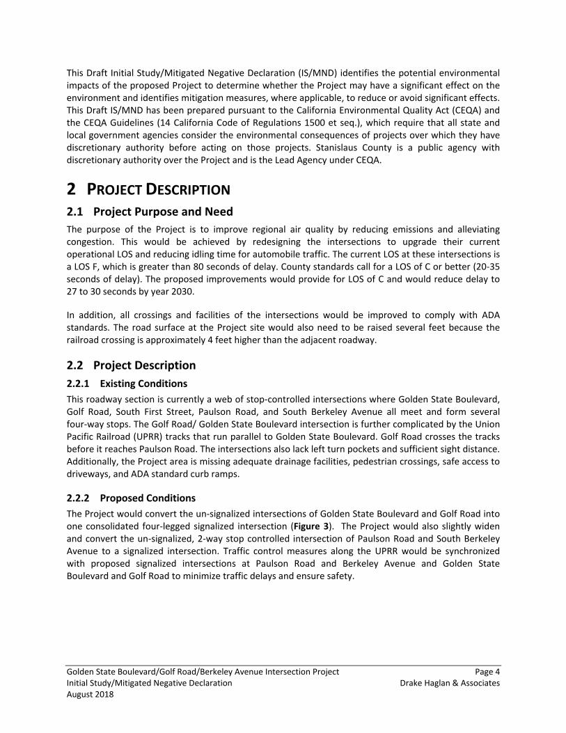
This Draft Initial Study/Mitigated Negative Declaration (IS/MND) identifies the potential environmental impacts of the proposed Project to determine whether the Project may have a significant effect on the environment and identifies mitigation measures, where applicable, to reduce or avoid significant effects. This Draft IS/MND has been prepared pursuant to the California Environmental Quality Act (CEQA) and the CEQA Guidelines (14 California Code of Regulations 1500 et seq.), which require that all state and local government agencies consider the environmental consequences of projects over which they have discretionary authority before acting on those projects. Stanislaus County is a public agency with discretionary authority over the Project and is the Lead Agency under CEQA.
2 PROJECT DESCRIPTION Project Purpose and Need 2.1
The purpose of the Project is to improve regional air quality by reducing emissions and alleviating congestion. This would be achieved by redesigning the intersections to upgrade their current operational LOS and reducing idling time for automobile traffic. The current LOS at these intersections is a LOS F, which is greater than 80 seconds of delay. County standards call for a LOS of C or better (20-35 seconds of delay). The proposed improvements would provide for LOS of C and would reduce delay to 27 to 30 seconds by year 2030.
In addition, all crossings and facilities of the intersections would be improved to comply with ADA standards. The road surface at the Project site would also need to be raised several feet because the railroad crossing is approximately 4 feet higher than the adjacent roadway.
Project Description 2.22.2.1 Existing Conditions This roadway section is currently a web of stop-controlled intersections where Golden State Boulevard, Golf Road, South First Street, Paulson Road, and South Berkeley Avenue all meet and form several four-way stops. The Golf Road/ Golden State Boulevard intersection is further complicated by the Union Pacific Railroad (UPRR) tracks that run parallel to Golden State Boulevard. Golf Road crosses the tracks before it reaches Paulson Road. The intersections also lack left turn pockets and sufficient sight distance. Additionally, the Project area is missing adequate drainage facilities, pedestrian crossings, safe access to driveways, and ADA standard curb ramps.
2.2.2 Proposed Conditions The Project would convert the un-signalized intersections of Golden State Boulevard and Golf Road into one consolidated four-legged signalized intersection (Figure 3). The Project would also slightly widen and convert the un-signalized, 2-way stop controlled intersection of Paulson Road and South Berkeley Avenue to a signalized intersection. Traffic control measures along the UPRR would be synchronized with proposed signalized intersections at Paulson Road and Berkeley Avenue and Golden State Boulevard and Golf Road to minimize traffic delays and ensure safety.
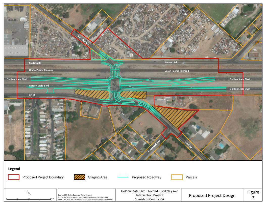
Figure3Proposed Project DesignSource: ESRI Online Basemap, Aerial Imagery
Coordinate System NAD 83 State Plane California III FIPS 0403 FeetNotes: This map was created for informational and display purposes only
LegendProposed Project Boundary Staging Area Proposed Roadway Parcels
"
0 190 38095 Feet
Golden State Blvd - Golf Rd - Berkeley AveIntersection Project
Stanislaus County, CA
Berkeley Ave
Golf Rd
Paulson Rd
Union Pacific Railroad
Golden State BlvdGolden State Blvd
1st St
Paulson Rd
Union Pacific Railroad
Golden State Blvd
Golden State Blvd
E Linwood Ave
Golden State Boulevard/Golf Road/Berkeley Avenue Intersection Project Page 6 Initial Study/Mitigated Negative Declaration Drake Haglan & Associates August 2018
The Project would restrict northbound access to South 1st Street by constructing a right-in/right-out intersection where South 1st Street terminates at Golf Road. The right-in/right-out intersection at South 1st Street and Golf Road would include a raised concrete median that would restrict southbound traffic along South 1st Street from making a left turn onto Golf Road, and northbound traffic along Golf Road from making a direct left turn onto South 1st street. Northbound traffic along Golf Road would still be able to access northbound South 1st Street by performing a U-turn at the proposed signalized Golden State Boulevard/Golf Road intersection, located 100 feet to the northeast of the proposed right-in/right-out intersection. Access to Golden State Boulevard from South 1st Street would be maintained through the implementation of a right-in/right-out access located along Golden State Boulevard, located approximately 500 feet northwest of the intersection of Golf Road and South 1st Street.
2.2.3 Utility Relocation Known utilities within the Project site include underground and overhead utilities. Prior to Project construction, the County would coordinate with impacted utility companies to ensure that all utilities are properly relocated to facilitate the construction of the proposed Project improvements.
2.2.4 Right-of-Way Construction of the proposed improvements would mostly occur within the County right-of-way. However, partial land acquisitions from private property owners may be required to accommodate the construction of Project improvements. During the construction phase, to facilitate construction of proposed improvements, temporary construction easements (TCE) and/or rights of entry would be required from adjacent properties and UPRR. All right-of-way acquisitions, TCEs, and rights of entry would be secured prior to construction during the Project right-of-way phase.
2.2.5 Construction Access Golden State, Golf Road, Berkeley Avenue, South 1st Street, and Paulson Road would remain open during construction with implementation of temporary lane closures and one-way traffic control, when necessary. Traffic detours around the Project site would not be implemented.
2.2.6 Demolition Demolition of existing asphalt would be performed in accordance with County standards supplemented by the Caltrans Specifications modified to meet environmental permit requirements. The construction contractor would prepare a demolition plan.
Construction Activities 2.3Construction would consist of the following activities in this general order:
• Construction staging and traffic control; • Clearing and grubbing; • General demolition of asphalt, roadway excavation, etc.; and • Construction of Project improvements.
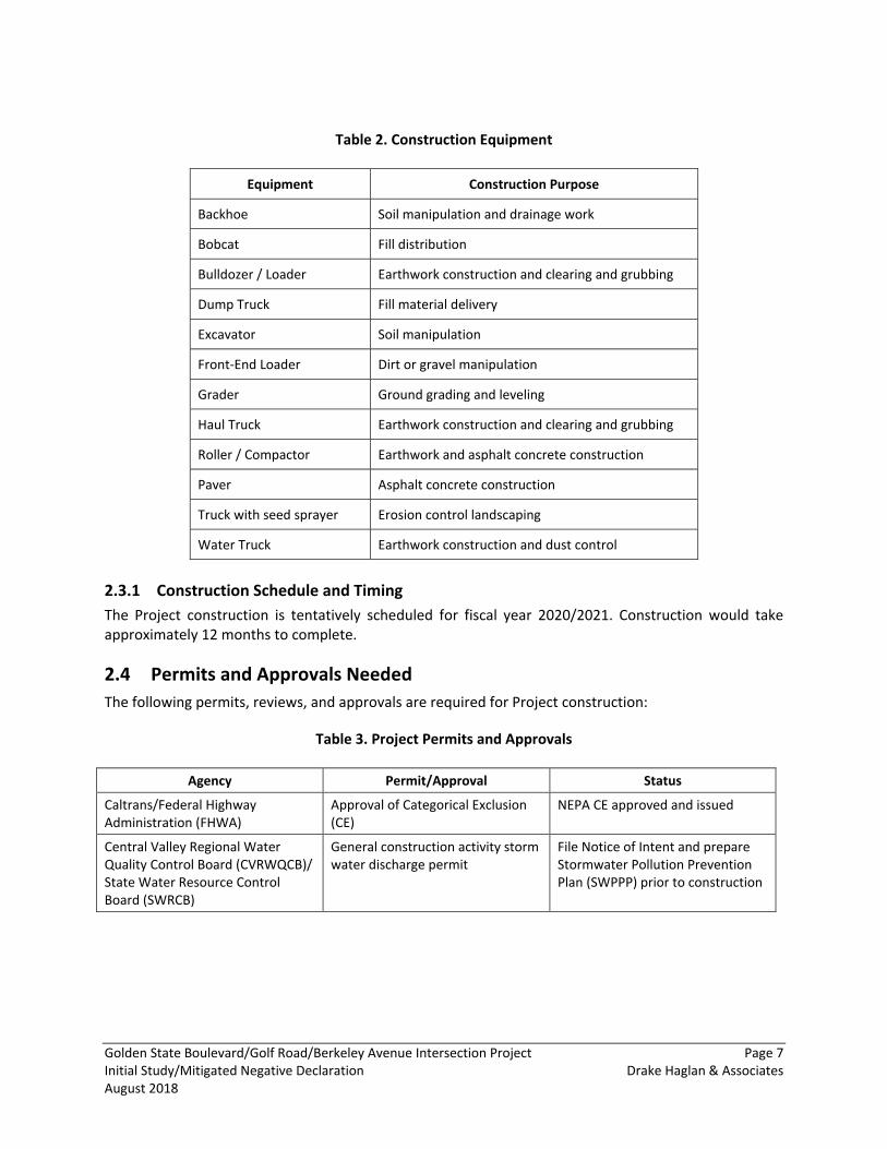
Table 2 provides a description of the type of equipment likely to be used during the construction of the proposed Project and may vary depending upon contractor discretion.
Golden State Boulevard/Golf Road/Berkeley Avenue Intersection Project Page 7 Initial Study/Mitigated Negative Declaration Drake Haglan & Associates August 2018
Table 2. Construction Equipment
Equipment Construction Purpose
Backhoe Soil manipulation and drainage work
Bobcat Fill distribution
Bulldozer / Loader Earthwork construction and clearing and grubbing
Dump Truck Fill material delivery
Excavator Soil manipulation
Front-End Loader Dirt or gravel manipulation
Grader Ground grading and leveling
Haul Truck Earthwork construction and clearing and grubbing
Roller / Compactor Earthwork and asphalt concrete construction
Paver Asphalt concrete construction
Truck with seed sprayer Erosion control landscaping
Water Truck Earthwork construction and dust control
2.3.1 Construction Schedule and Timing The Project construction is tentatively scheduled for fiscal year 2020/2021. Construction would take approximately 12 months to complete.
Permits and Approvals Needed 2.4The following permits, reviews, and approvals are required for Project construction:
Table 3. Project Permits and Approvals
Agency Permit/Approval Status
Caltrans/Federal Highway Administration (FHWA)
Approval of Categorical Exclusion (CE)
NEPA CE approved and issued
Central Valley Regional Water Quality Control Board (CVRWQCB)/ State Water Resource Control Board (SWRCB)
General construction activity storm water discharge permit
File Notice of Intent and prepare Stormwater Pollution Prevention Plan (SWPPP) prior to construction
Golden State Boulevard/Golf Road/Berkeley Avenue Intersection Project Page 9 Initial Study/Mitigated Negative Declaration Drake Haglan & Associates August 2018
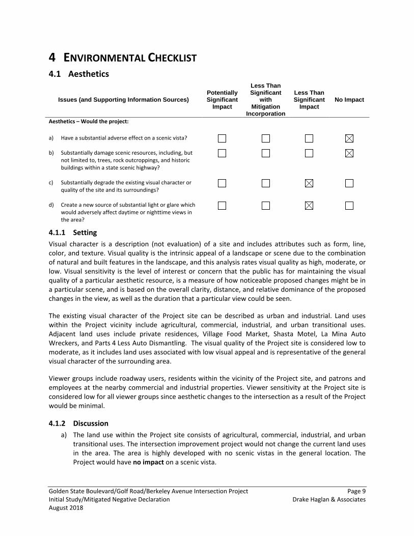
4 ENVIRONMENTAL CHECKLIST Aesthetics 4.1
Issues (and Supporting Information Sources) Potentially Significant
Impact
Less Than Significant
with Mitigation
Incorporation
Less Than Significant
Impact No Impact
Aesthetics – Would the project: a) Have a substantial adverse effect on a scenic vista?
b) Substantially damage scenic resources, including, but not limited to, trees, rock outcroppings, and historic buildings within a state scenic highway?
c) Substantially degrade the existing visual character or quality of the site and its surroundings?
d) Create a new source of substantial light or glare which would adversely affect daytime or nighttime views in the area?
4.1.1 Setting Visual character is a description (not evaluation) of a site and includes attributes such as form, line, color, and texture. Visual quality is the intrinsic appeal of a landscape or scene due to the combination of natural and built features in the landscape, and this analysis rates visual quality as high, moderate, or low. Visual sensitivity is the level of interest or concern that the public has for maintaining the visual quality of a particular aesthetic resource, is a measure of how noticeable proposed changes might be in a particular scene, and is based on the overall clarity, distance, and relative dominance of the proposed changes in the view, as well as the duration that a particular view could be seen.
The existing visual character of the Project site can be described as urban and industrial. Land uses within the Project vicinity include agricultural, commercial, industrial, and urban transitional uses. Adjacent land uses include private residences, Village Food Market, Shasta Motel, La Mina Auto Wreckers, and Parts 4 Less Auto Dismantling. The visual quality of the Project site is considered low to moderate, as it includes land uses associated with low visual appeal and is representative of the general visual character of the surrounding area.
Viewer groups include roadway users, residents within the vicinity of the Project site, and patrons and employees at the nearby commercial and industrial properties. Viewer sensitivity at the Project site is considered low for all viewer groups since aesthetic changes to the intersection as a result of the Project would be minimal.
4.1.2 Discussion a) The land use within the Project site consists of agricultural, commercial, industrial, and urban
transitional uses. The intersection improvement project would not change the current land uses in the area. The area is highly developed with no scenic vistas in the general location. The Project would have no impact on a scenic vista.
Golden State Boulevard/Golf Road/Berkeley Avenue Intersection Project Page 10 Initial Study/Mitigated Negative Declaration Drake Haglan & Associates August 2018
b) A review of the current Caltrans Map of Designated Scenic Routes indicates that the only officially designated scenic highway within Stanislaus County is Interstate 5 between SR 152 and SR 205 (Caltrans 2017c). This scenic highway is approximately 17 miles to the west of the Project site. The Project is not located near any officially designated or eligible scenic highway. Therefore, the Project would have no impact on scenic resources associated with a scenic highway or roadways and no mitigation measures are required.
c) The visual character of the Project would be compatible with the existing visual character of the corridor. The Project would not affect the pattern elements (landscaping trees and vegetation) of the Project area. The Project would not interrupt land use diversity with addition of new land uses.
Viewer groups include adjacent residents and motorists along Golden State Boulevard, Golf Road, Berkeley Avenue, Paulson Road, and Frontage Road. Viewer sensitivity to the proposed roadway changes is considered low because the intersection would have low visual dominance. Construction of the Project would result in temporary changes in local visual conditions, such as clearing and grading at the Project site. Any area disturbed during construction would be revegetated with native and appropriate vegetation to minimize erosion and visual contrast with the existing area. Given the relatively short-term nature of these construction-related activities, construction-related visual impacts would be considered less than significant and no mitigation measures are required.
The Project is an intersection improvement project that would resemble the existing visual characteristics at the Project site. No new structures would be constructed as a result of the Project. The Project would result in less-than-significant impacts to the permanent visual character of the Project site and no mitigation measures are required.
d) The Project site is not located within an urban setting where street lighting is common. Existing street lighting at the Project site is limited to the intersection of Golden State Boulevard and Golf Road. Roadway traffic and lighting from private properties are also sources of nighttime light. The Project would not result in any changes that would introduce new sources of light and glare (i.e., billboards, street lamps, security lighting, etc.) to the vicinity of the Project site. Additionally, it is not the purpose of the Project to increase roadway capacity, so greater numbers of vehicles would not be introduced in this area as a result of construction of the Project. Consequently, the Project would have a less-than-significant impact and no mitigation measures are required.
Golden State Boulevard/Golf Road/Berkeley Avenue Intersection Project Page 11 Initial Study/Mitigated Negative Declaration Drake Haglan & Associates August 2018
Agricultural and Forest Resources 4.2
Issues (and Supporting Information Sources) Potentially Significant
Impact
Less Than Significant
with Mitigation
Incorporation
Less Than Significant
Impact No Impact
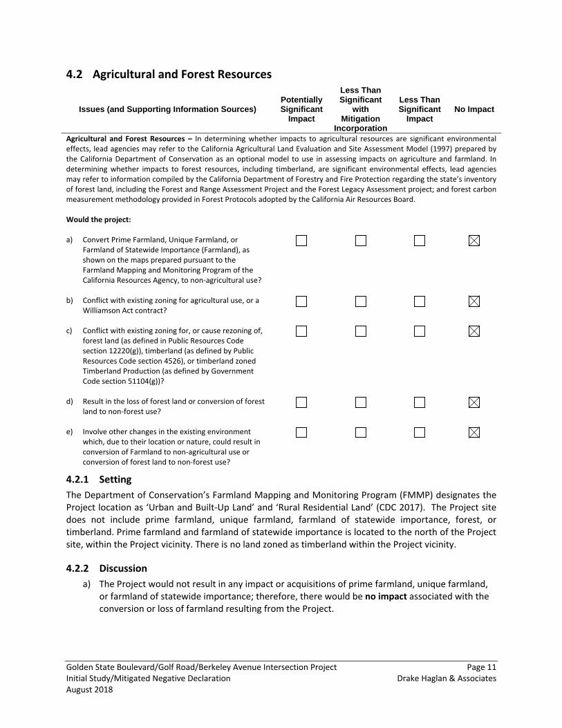
Agricultural and Forest Resources – In determining whether impacts to agricultural resources are significant environmental effects, lead agencies may refer to the California Agricultural Land Evaluation and Site Assessment Model (1997) prepared by the California Department of Conservation as an optional model to use in assessing impacts on agriculture and farmland. In determining whether impacts to forest resources, including timberland, are significant environmental effects, lead agencies may refer to information compiled by the California Department of Forestry and Fire Protection regarding the state’s inventory of forest land, including the Forest and Range Assessment Project and the Forest Legacy Assessment project; and forest carbon measurement methodology provided in Forest Protocols adopted by the California Air Resources Board. Would the project: a) Convert Prime Farmland, Unique Farmland, or
Farmland of Statewide Importance (Farmland), as shown on the maps prepared pursuant to the Farmland Mapping and Monitoring Program of the California Resources Agency, to non-agricultural use?
b) Conflict with existing zoning for agricultural use, or a Williamson Act contract?
c) Conflict with existing zoning for, or cause rezoning of, forest land (as defined in Public Resources Code section 12220(g)), timberland (as defined by Public Resources Code section 4526), or timberland zoned Timberland Production (as defined by Government Code section 51104(g))?
d) Result in the loss of forest land or conversion of forest land to non-forest use?
e) Involve other changes in the existing environment which, due to their location or nature, could result in conversion of Farmland to non-agricultural use or conversion of forest land to non-forest use?
4.2.1 Setting The Department of Conservation’s Farmland Mapping and Monitoring Program (FMMP) designates the Project location as ‘Urban and Built-Up Land’ and ‘Rural Residential Land’ (CDC 2017). The Project site does not include prime farmland, unique farmland, farmland of statewide importance, forest, or timberland. Prime farmland and farmland of statewide importance is located to the north of the Project site, within the Project vicinity. There is no land zoned as timberland within the Project vicinity.
4.2.2 Discussion a) The Project would not result in any impact or acquisitions of prime farmland, unique farmland,
or farmland of statewide importance; therefore, there would be no impact associated with the conversion or loss of farmland resulting from the Project.
Golden State Boulevard/Golf Road/Berkeley Avenue Intersection Project Page 12 Initial Study/Mitigated Negative Declaration Drake Haglan & Associates August 2018
b) The Project would not result in any impacts to any lands covered by a Williamson Act contract. There would be no impact and no mitigation measures are required.
c) Land uses in the Project vicinity are designated as agricultural, commercial, industrial, and urban transitional. The Project site is not within an area zoned for forestland or timberland. There would no impact and no mitigation measures are required.
d) The Project is not located near any forest land. No forest conversion would occur as a result in the loss of forest land or conversion of forest land. There would be no impact and no mitigation measures are required.
e) As discussed above in ‘Setting’ of this section, impacted area within the Project consists of Urban and Built-Up Land and Rural Residential Land. The Project does not propose any new land uses or the permanent conversion of existing agricultural lands. There would be no impact and no mitigation measures are required.
Golden State Boulevard/Golf Road/Berkeley Avenue Intersection Project Page 13 Initial Study/Mitigated Negative Declaration Drake Haglan & Associates August 2018
Air Quality 4.3
Issues (and Supporting Information Sources): Potentially Significant
Impact
Less Than Significant
with Mitigation
Incorporation
Less Than Significant
Impact No Impact
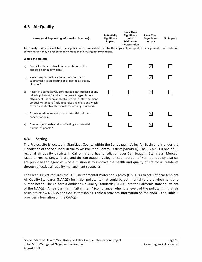
Air Quality – Where available, the significance criteria established by the applicable air quality management or air pollution control district may be relied upon to make the following determinations. Would the project: a) Conflict with or obstruct implementation of the
applicable air quality plan?
b) Violate any air quality standard or contribute substantially to an existing or projected air quality violation?
c) Result in a cumulatively considerable net increase of any criteria pollutant for which the project region is non-attainment under an applicable federal or state ambient air quality standard (including releasing emissions which exceed quantitative thresholds for ozone precursors)?
d) Expose sensitive receptors to substantial pollutant concentrations?
e) Create objectionable odors affecting a substantial number of people?
4.3.1 Setting The Project site is located in Stanislaus County within the San Joaquin Valley Air Basin and is under the jurisdiction of the San Joaquin Valley Air Pollution Control District (SJVAPCD). The SJVAPCD is one of 35 regional air quality districts in California and has jurisdiction over San Joaquin, Stanislaus, Merced, Madera, Fresno, Kings, Tulare, and the San Joaquin Valley Air Basin portion of Kern. Air quality districts are public health agencies whose mission is to improve the health and quality of life for all residents through effective air quality management strategies.
The Clean Air Act requires the U.S. Environmental Protection Agency (U.S. EPA) to set National Ambient Air Quality Standards (NAAQS) for major pollutants that could be detrimental to the environment and human health. The California Ambient Air Quality Standards (CAAQS) are the California state equivalent of the NAAQS. An air basin is in “attainment” (compliance) when the levels of the pollutant in that air basin are below NAAQS and CAAQS thresholds. Table 4 provides information on the NAAQS and Table 5 provides information on the CAAQS.
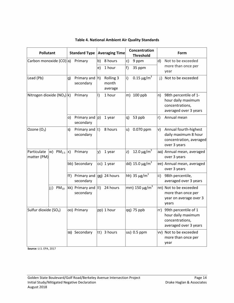
Golden State Boulevard/Golf Road/Berkeley Avenue Intersection Project Page 14 Initial Study/Mitigated Negative Declaration Drake Haglan & Associates August 2018
Table 4. National Ambient Air Quality Standards
Pollutant Standard Type Averaging Time Concentration
Threshold Form
Carbon monoxide (CO) a) Primary b) 8 hours c) 9 ppm d) Not to be exceeded more than once per year
e) 1 hour f) 35 ppm
Lead (Pb) g) Primary and secondary
h) Rolling 3 month average
i) 0.15 μg/m3 j) Not to be exceeded
Nitrogen dioxide (NO2) k) Primary l) 1 hour m) 100 ppb n) 98th percentile of 1-hour daily maximum concentrations, averaged over 3 years
o) Primary and secondary
p) 1 year q) 53 ppb r) Annual mean
Ozone (O3) s) Primary and secondary
t) 8 hours u) 0.070 ppm v) Annual fourth-highest daily maximum 8 hour concentration, averaged over 3 years
Particulate matter (PM)
w) PM2.5 x) Primary y) 1 year z) 12.0 μg/m3 aa) Annual mean, averaged over 3 years
bb) Secondary cc) 1 year dd) 15.0 μg/m3 ee) Annual mean, averaged over 3 years
ff) Primary and secondary
gg) 24 hours hh) 35 μg/m3 ii) 98th percentile, averaged over 3 years
jj) PM10 kk) Primary and secondary
ll) 24 hours mm) 150 μg/m3 nn) Not to be exceeded more than once per year on average over 3 years
Sulfur dioxide (SO2) oo) Primary pp) 1 hour qq) 75 ppb rr) 99th percentile of 1 hour daily maximum concentrations, averaged over 3 years
ss) Secondary tt) 3 hours uu) 0.5 ppm vv) Not to be exceeded more than once per year
Source: U.S. EPA, 2017
Golden State Boulevard/Golf Road/Berkeley Avenue Intersection Project Page 15 Initial Study/Mitigated Negative Declaration Drake Haglan & Associates August 2018
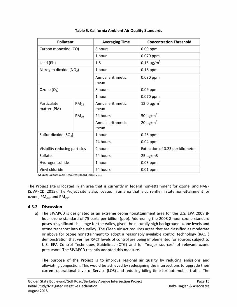
Table 5. California Ambient Air Quality Standards
Pollutant Averaging Time Concentration Threshold
Carbon monoxide (CO) 8 hours 0.09 ppm
1 hour 0.070 ppm
Lead (Pb) 1.5 0.15 μg/m3
Nitrogen dioxide (NO2) 1 hour 0.18 ppm
Annual arithmetic mean
0.030 ppm
Ozone (O3) 8 hours 0.09 ppm
1 hour 0.070 ppm
Particulate matter (PM)
PM2.5 Annual arithmetic mean
12.0 μg/m3
PM10 24 hours 50 μg/m3
Annual arithmetic mean
20 µg/m3
Sulfur dioxide (SO2) 1 hour 0.25 ppm
24 hours 0.04 ppm
Visibility reducing particles 9 hours Extinction of 0.23 per kilometer
Sulfates 24 hours 25 µg/m3
Hydrogen sulfide 1 hour 0.03 ppm
Vinyl chloride 24 hours 0.01 ppm Source: California Air Resources Board (ARB), 2016
The Project site is located in an area that is currently in federal non-attainment for ozone, and PM2.5
(SJVAPCD, 2015). The Project site is also located in an area that is currently in state non-attainment for ozone, PM2.5, and PM10.
4.3.2 Discussion a) The SJVAPCD is designated as an extreme ozone nonattainment area for the U.S. EPA 2008 8-
hour ozone standard of 75 parts per billion (ppb). Addressing the 2008 8-hour ozone standard poses a significant challenge for the Valley, given the naturally high background ozone levels and ozone transport into the Valley. The Clean Air Act requires areas that are classified as moderate or above for ozone nonattainment to adopt a reasonably available control technology (RACT) demonstration that verifies RACT levels of control are being implemented for sources subject to U.S. EPA Control Techniques Guidelines (CTG) and for “major sources” of relevant ozone precursors. The SJVAPCD recently adopted this measure. The purpose of the Project is to improve regional air quality by reducing emissions and alleviating congestion. This would be achieved by redesigning the intersections to upgrade their current operational Level of Service (LOS) and reducing idling time for automobile traffic. The
Golden State Boulevard/Golf Road/Berkeley Avenue Intersection Project Page 16 Initial Study/Mitigated Negative Declaration Drake Haglan & Associates August 2018
current LOS at these intersections is a LOS F, which is greater than 80 seconds of delay. County standards call for a LOS of C or better (20-35 seconds of delay). The proposed improvements would provide for LOS of C and would reduce delay to 27 to 30 seconds by year 2030. The Project would not increase roadway capacity or service capabilities that would induce unplanned growth or remove an existing obstacle to growth. The Project would not increase long-term traffic levels and in fact operational impacts to air quality are supposed to improve as a result of the Project. Therefore, the Project would not conflict with the region’s air quality management plans and would be considered a less-than-significant impact and no mitigation measures are required.
b) Since the Project would not add lanes or increase capacity, it would only affect local air pollutants during construction (approximately one year). The Project would not affect long-term air pollutant emissions in the area or stationary air pollutant sources.
Construction
The primary concern to the SJVAPCD during construction would be PM10 emissions from dust-generating activities. Incremental increases in dust generated from projects are considered a significant air quality impact requiring mitigation. During construction, the Project would minimize potential toxic air contaminates through implementation of Avoidance and Minimization Measures AIR-1 through AIR-. With implementation of these required controls, PM10 impacts from construction of the Project would be less than significant and no mitigation measures are required.
Operations
The Project would not result in increased capacity or additional vehicle trips. The Project would not increase long-term traffic levels. There would be no impact to air quality under full operation of the Project and no mitigation measures are required.
c) As discussed above under Item b), the Project would result in minimal air pollutant emissions during the short-term duration of construction. In addition, the Project would not result in any new operational activities or emissions. Therefore, the Project would not result in a cumulatively considerable net increase of any criteria pollutant for which the Project region is non-attainment under an applicable federal or state ambient air quality standard. Consequently, this impact would be less than significant and no mitigation measures are required.
d) A sensitive receptor is typically defined as facilities or land uses that include members of the population that are particularly sensitive to the effects of air pollutants, such as children, the elderly, and people with illnesses. Examples include schools, hospitals, and residential areas. There are multiple sensitive receptors located in proximity to the Project site. There are three sensitive receptors located within approximately 100 feet of the Project site including APN 043-017-020, APN 044-030-001, and APN 043-020-002.
Construction activities would occur over a brief duration within the estimated one-year construction timeline. Residents located adjacent to the Project site and within the vicinity would be exposed to construction air-borne contaminants only for the duration of construction.
Golden State Boulevard/Golf Road/Berkeley Avenue Intersection Project Page 17 Initial Study/Mitigated Negative Declaration Drake Haglan & Associates August 2018
The brevity of the exposure period would substantially limit exposure to pollutant concentrations. This brief exposure period is less than the 2-year exposure period typically assumed for health risk analysis for small construction projects. With implementation of Avoidance and Minimization Measures AIR-1 through AIR-4, construction of the Project would not expose sensitive receptors to substantial pollutant concentrations. In addition, Project operations would not result in increased level of air pollutants. With the implementation of required controls, the impact would be less than significant and no mitigation measures are required.
e) Generally, the types of projects or activities that pose potential odor problems include refineries, chemical plants, wastewater treatment plants, landfills, composting facilities, and transfer stations. The Project is an intersection improvement project that is located within a suburban area and would not create objectionable odors affecting a substantial number of people. This impact would be less than significant and no mitigation measures are required.
4.3.3 Avoidance and Minimization Measures Avoidance and Minimization Measure: AIR-1: The following air quality controls are required to be implemented at all construction sites.
• All disturbed areas, including storage piles, which are not being actively utilized for construction purposes, shall be effectively stabilized of dust emissions using water, chemical stabilizer/ suppressant, covered with a tarp or other suitable cover, or vegetative ground cover.
• All on-site unpaved roads and off-site unpaved access roads shall be effectively stabilized of dust emissions using water or chemical stabilizer/suppressant.
• All land clearing, grubbing, scraping, excavation, land leveling, grading, cut and fill, and demolition activities shall be effectively controlled of fugitive dust emissions utilizing application of water or by presoaking.
• When materials are transported off-site, all material shall be covered or effectively wetted to limit visible dust emissions, and at least 6 inches of freeboard space from the top of the container shall be maintained.
• All operations shall limit or expeditiously remove the accumulation of mud or dirt from adjacent public streets at the end of each workday. (The use of dry rotary brushes is expressly prohibited except where preceded or accompanied by sufficient wetting to limit the visible dust emissions. Use of blower devices is expressly forbidden.)
• Following the addition of materials to, or the removal of materials from, the surface of outdoor storage piles, said piles shall be effectively stabilized of fugitive dust emissions utilizing sufficient water or chemical stabilizer/suppressant.
• Within urban areas, trackout shall be immediately removed when it extends 50 feet or more from the site and at the end of each workday.
• Any site with 150 or more vehicle trips per day, or 20 or more vehicle trips per day by vehicles with three or more axles, shall implement measures to prevent carryout and trackout.
Avoidance and Minimization Measure AIR-2: The following measures should be implemented at construction sites when required to mitigate significant PM10 impacts (note, these measures are to be implemented in addition to Regulation VIII requirements):
Golden State Boulevard/Golf Road/Berkeley Avenue Intersection Project Page 18 Initial Study/Mitigated Negative Declaration Drake Haglan & Associates August 2018
• Limit traffic speeds on unpaved roads to 15 mph; and • Install sandbags or other erosion control measures to prevent silt runoff to public roadways
from sites with a slope greater than one percent.
Avoidance and Minimization Measure 3: The following control measures are strongly encouraged at construction sites that are large in area, located near sensitive receptors, or which for any other reason warrant additional emissions reductions:
• Install wheel washers for all exiting trucks, or wash off all trucks and equipment leaving the site; • Install wind breaks at windward side(s) of construction areas; • Suspend excavation and grading activity when winds exceed 20 mph; and • Limit area subject to excavation, grading, and other construction activity at any one time
regardless of wind speed.
Avoidance and Minimization Measure AIR-4: Heavy duty equipment (scrapers, graders, trenchers, earth movers, etc.):
• Use alternative fueled or catalyst equipped diesel construction equipment • Minimize idling time (e.g., 5 minutes maximum) • Replace fossil-fueled equipment with electrically driven equivalents (provided they are not run
via a portable generator set) • Curtail construction during periods of high ambient pollutant concentrations; this may include
ceasing of construction activity during the peak-hour of vehicular traffic on adjacent roadways • Implement activity management (e.g. rescheduling activities to reduce short-term impacts)
Golden State Boulevard/Golf Road/Berkeley Avenue Intersection Project Page 19 Initial Study/Mitigated Negative Declaration Drake Haglan & Associates August 2018
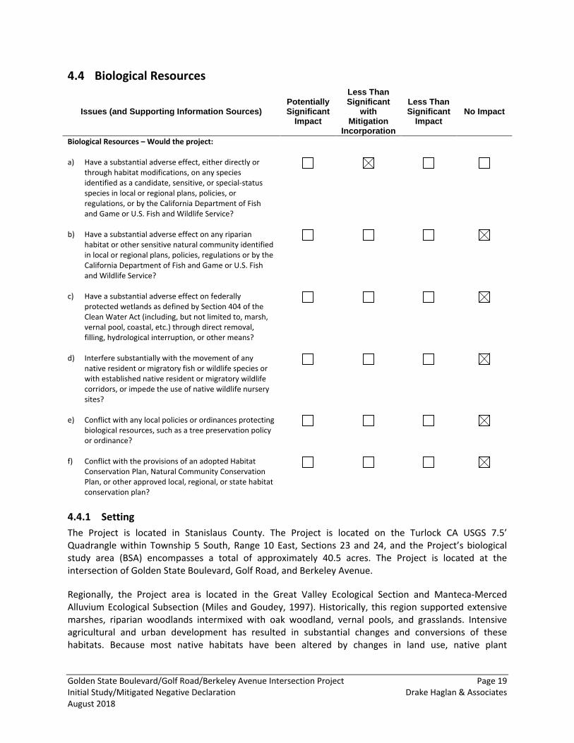
Biological Resources 4.4
Issues (and Supporting Information Sources) Potentially Significant
Impact
Less Than Significant
with Mitigation
Incorporation
Less Than Significant
Impact No Impact
Biological Resources – Would the project: a) Have a substantial adverse effect, either directly or
through habitat modifications, on any species identified as a candidate, sensitive, or special-status species in local or regional plans, policies, or regulations, or by the California Department of Fish and Game or U.S. Fish and Wildlife Service?
b) Have a substantial adverse effect on any riparian habitat or other sensitive natural community identified in local or regional plans, policies, regulations or by the California Department of Fish and Game or U.S. Fish and Wildlife Service?
c) Have a substantial adverse effect on federally protected wetlands as defined by Section 404 of the Clean Water Act (including, but not limited to, marsh, vernal pool, coastal, etc.) through direct removal, filling, hydrological interruption, or other means?
d) Interfere substantially with the movement of any native resident or migratory fish or wildlife species or with established native resident or migratory wildlife corridors, or impede the use of native wildlife nursery sites?
e) Conflict with any local policies or ordinances protecting biological resources, such as a tree preservation policy or ordinance?
f) Conflict with the provisions of an adopted Habitat Conservation Plan, Natural Community Conservation Plan, or other approved local, regional, or state habitat conservation plan?
4.4.1 Setting The Project is located in Stanislaus County. The Project is located on the Turlock CA USGS 7.5’ Quadrangle within Township 5 South, Range 10 East, Sections 23 and 24, and the Project’s biological study area (BSA) encompasses a total of approximately 40.5 acres. The Project is located at the intersection of Golden State Boulevard, Golf Road, and Berkeley Avenue.
Regionally, the Project area is located in the Great Valley Ecological Section and Manteca-Merced Alluvium Ecological Subsection (Miles and Goudey, 1997). Historically, this region supported extensive marshes, riparian woodlands intermixed with oak woodland, vernal pools, and grasslands. Intensive agricultural and urban development has resulted in substantial changes and conversions of these habitats. Because most native habitats have been altered by changes in land use, native plant
Golden State Boulevard/Golf Road/Berkeley Avenue Intersection Project Page 20 Initial Study/Mitigated Negative Declaration Drake Haglan & Associates August 2018
communities are typically limited to areas along water courses and drainages, within designated reserves, or on untilled pasture lands.
4.4.2 Data Sources/Methodology The Technical Memorandum for Biological Resources for the Golden State Boulevard/Golf Road/Berkeley Avenue Intersection Project (memo) was prepared for the Project and is available for review at the County. An evaluation of biological resources was conducted to determine whether any special-status plant or wildlife species, or their habitat, or sensitive habitats occurs in the Project’s BSA. Data on special-status species and habitats known in the area was obtained from state and federal agencies. Maps and aerial photographs of the BSA and surrounding areas were reviewed. Field surveys were conducted by Drake Haglan and Associates on August 8, 2016, to determine the habitats present.
4.4.3 Regional Species and Habitats of Concern The Project is located in a built environment consisting entirely of residential housing, commercial and industrial businesses, and urban streets. The high level of disturbance associated with the land uses and the nature of the urban/landscape vegetation makes the Project site of overall low value to wildlife. While there is no habitat within the study area that would support special-status species, the large pine trees (Pinus sp.) and other mature trees could provide potential nesting sites for migratory songbirds. Although the Project would not remove any trees, the close proximity of construction activities to large, mature trees could affect nesting birds if present. The Project could also have impacts related to invasive vegetation species. The Project would not result in impacts on wetlands or special status species.
4.4.4 Discussion a) The Project is located in a built environment consisting entirely of residential housing,
commercial and industrial businesses, and urban streets. The high level of disturbance associated with the land uses and the nature of the urban/landscape vegetation makes the Project site of overall low value to wildlife. The Project would not result in impacts on wetlands or special status species. No candidate, sensitive, or special status species were observed in the Project area during the biological resource survey conducted in August of 2016.
However, the large pine trees (Pinus sp.) and other mature trees could provide potential nesting sites for migratory songbirds. No bird nests were observed during the biological survey on August 8, 2016. Although the Project would not remove any trees, the close proximity of construction activities to large, mature trees could affect nesting birds if present. These activities could cause disruption to nesting activity particularly if construction occurred during the nesting season (February 1 – August 31). Potential impacts on nesting birds can be avoided by delaying tree trimming and other construction activities in the immediate vicinity until the end of the nesting season. In addition, prior to construction, a tree survey would be needed to determine whether there are active nests in one or more of the trees on or adjacent to the Project site.
With the implementation of MM BIO-1 and MM BIO-2, the Project would have a less-than-significant impact on special status species.
Golden State Boulevard/Golf Road/Berkeley Avenue Intersection Project Page 21 Initial Study/Mitigated Negative Declaration Drake Haglan & Associates August 2018
b) The Project is located at the intersection of Golden State Boulevard, Golf Road, and Berkeley Avenue and consists entirely of residential housing, commercial and industrial businesses, and urban streets. The high level of disturbance associated with the land uses and the nature of the urban/landscape vegetation makes the Project site of overall low value to wildlife. There is no riparian habitat or other natural sensitive areas located in the proximity of the Project. This condition precludes the possibility of impacts, and no impact would occur.
c) Because most native habitats have been altered by changes in land use, native plant communities are typically limited to areas along water courses and drainages, within designated reserves, or on untilled pasture lands. The Project site does not contain any waterways or isolated wetlands that would be classified as jurisdictional features. This condition precludes the possibility of impacts, and no impact would occur.
d) The general setting of the Project area is suburban and consists entirely of residential housing, commercial and industrial businesses, and urban streets. The Project would not substantially remove, degrade, or otherwise interfere with the structure or function of a wildlife movement corridor. The Project site does not contain any features commonly associated with wildlife or fish movement (waterways, arroyos, ridgelines, etc.). This condition precludes the possibility of impacts, and no impact would occur.
e) As of April 2018, Stanislaus County has not designated a local policy or ordinance for the preservation of trees. The Project would not result in the removal of trees or conflict with local policies and ordinances protecting biological resources. The Project would result in no impact.
f) The Project is not located in an area with a Habitat Conservation Plan or Natural Community Conservation Plan, therefore, there would be no impact.
4.4.5 Mitigation Measures MM BIO-1: Nesting Migratory Birds – Preconstruction Tree Surveys. To ensure there are no effects on nesting birds, a qualified biologist will conduct preconstruction tree surveys of the trees to be trimmed and all trees within 100 feet of the Project construction area. Survey work will be done no more than two days prior to initiation of construction to minimize potential that nests are initiated after the survey and prior to the start of construction. If any occupied nests are detected, the tree will be flagged, a minimum buffer of 50 feet between the nest and construction zone will be established, and that area will be avoided until the qualified biologist has determined the nest is no longer active/occupied. Once the biologist has determined that young have fledged and the nest is no longer active, construction can resume in that area.
MM BIO-2: Invasive Species Management. The Project is located in a built environment with few areas of open land. The roadside vegetation is primarily urban landscape—mixed vegetation planters, shrubs, strips of lawn, and street trees; some ruderal areas; and mainly nonnative species. Construction activities and inappropriate erosion control measures could result in the introduction and spread of noxious weeds and other invasive plants. Measures will be used to ensure that no new invasive species are introduced into the Project location. These measures may include the following:
Golden State Boulevard/Golf Road/Berkeley Avenue Intersection Project Page 22 Initial Study/Mitigated Negative Declaration Drake Haglan & Associates August 2018
• Construction crew training about invasive plant identification and the importance of controlling and preventing the spread of invasive plant infestations;
• Surface disturbance in the construction work area will be minimized to the greatest extent possible;
• Where erosion control plantings are used, areas will be seeded with certified weed-free native mixes and, if appropriate, mulched with certified weed-free mulch to prevent invasive species from colonizing.
• Revegetation of landscape areas will use native species, to the extent possible, and no invasive species will be used.
Golden State Boulevard/Golf Road/Berkeley Avenue Intersection Project Page 23 Initial Study/Mitigated Negative Declaration Drake Haglan & Associates August 2018
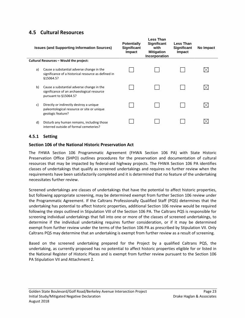
Cultural Resources 4.5
Issues (and Supporting Information Sources) Potentially Significant
Impact
Less Than Significant
with Mitigation
Incorporation
Less Than Significant
Impact No Impact
Cultural Resources – Would the project:
a) Cause a substantial adverse change in the significance of a historical resource as defined in §15064.5?
b) Cause a substantial adverse change in the significance of an archaeological resource pursuant to §15064.5?
c) Directly or indirectly destroy a unique paleontological resource or site or unique geologic feature?
d) Disturb any human remains, including those interred outside of formal cemeteries?
4.5.1 Setting
Section 106 of the National Historic Preservation Act
The FHWA Section 106 Programmatic Agreement (FHWA Section 106 PA) with State Historic Preservation Office (SHPO) outlines procedures for the preservation and documentation of cultural resources that may be impacted by federal-aid highway projects. The FHWA Section 106 PA identifies classes of undertakings that qualify as screened undertakings and requires no further review when the requirements have been satisfactorily completed and it is determined that no feature of the undertaking necessitates further review.
Screened undertakings are classes of undertakings that have the potential to affect historic properties, but following appropriate screening, may be determined exempt from further Section 106 review under the Programmatic Agreement. If the Caltrans Professionally Qualified Staff (PQS) determines that the undertaking has potential to affect historic properties, additional Section 106 review would be required following the steps outlined in Stipulation VIII of the Section 106 PA. The Caltrans PQS is responsible for screening individual undertakings that fall into one or more of the classes of screened undertakings, to determine if the individual undertaking requires further consideration, or if it may be determined exempt from further review under the terms of the Section 106 PA as prescribed by Stipulation VII. Only Caltrans PQS may determine that an undertaking is exempt from further review as a result of screening.
Based on the screened undertaking prepared for the Project by a qualified Caltrans PQS, the undertaking, as currently proposed has no potential to affect historic properties eligible for or listed in the National Register of Historic Places and is exempt from further review pursuant to the Section 106 PA Stipulation VII and Attachment 2.
Golden State Boulevard/Golf Road/Berkeley Avenue Intersection Project Page 24 Initial Study/Mitigated Negative Declaration Drake Haglan & Associates August 2018
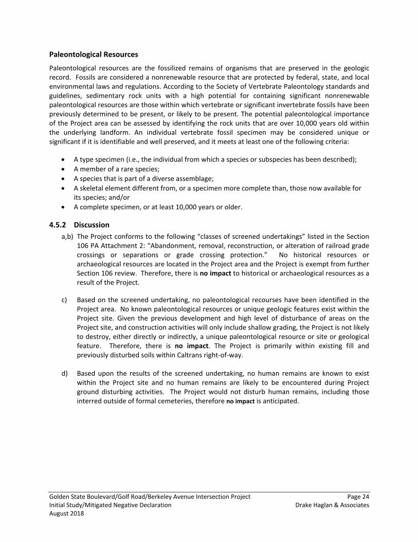
Paleontological Resources
Paleontological resources are the fossilized remains of organisms that are preserved in the geologic record. Fossils are considered a nonrenewable resource that are protected by federal, state, and local environmental laws and regulations. According to the Society of Vertebrate Paleontology standards and guidelines, sedimentary rock units with a high potential for containing significant nonrenewable paleontological resources are those within which vertebrate or significant invertebrate fossils have been previously determined to be present, or likely to be present. The potential paleontological importance of the Project area can be assessed by identifying the rock units that are over 10,000 years old within the underlying landform. An individual vertebrate fossil specimen may be considered unique or significant if it is identifiable and well preserved, and it meets at least one of the following criteria:
• A type specimen (i.e., the individual from which a species or subspecies has been described); • A member of a rare species; • A species that is part of a diverse assemblage; • A skeletal element different from, or a specimen more complete than, those now available for
its species; and/or • A complete specimen, or at least 10,000 years or older.
4.5.2 Discussion a,b) The Project conforms to the following “classes of screened undertakings” listed in the Section
106 PA Attachment 2: “Abandonment, removal, reconstruction, or alteration of railroad grade crossings or separations or grade crossing protection.” No historical resources or archaeological resources are located in the Project area and the Project is exempt from further Section 106 review. Therefore, there is no impact to historical or archaeological resources as a result of the Project.
c) Based on the screened undertaking, no paleontological recourses have been identified in the Project area. No known paleontological resources or unique geologic features exist within the Project site. Given the previous development and high level of disturbance of areas on the Project site, and construction activities will only include shallow grading, the Project is not likely to destroy, either directly or indirectly, a unique paleontological resource or site or geological feature. Therefore, there is no impact. The Project is primarily within existing fill and previously disturbed soils within Caltrans right-of-way.
d) Based upon the results of the screened undertaking, no human remains are known to exist within the Project site and no human remains are likely to be encountered during Project ground disturbing activities. The Project would not disturb human remains, including those interred outside of formal cemeteries, therefore no impact is anticipated.
Golden State Boulevard/Golf Road/Berkeley Avenue Intersection Project Page 25 Initial Study/Mitigated Negative Declaration Drake Haglan & Associates August 2018
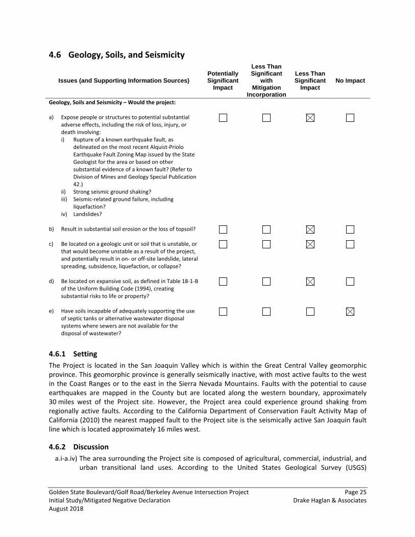
Geology, Soils, and Seismicity 4.6
Issues (and Supporting Information Sources) Potentially Significant
Impact
Less Than Significant
with Mitigation
Incorporation
Less Than Significant
Impact No Impact
Geology, Soils and Seismicity – Would the project: a) Expose people or structures to potential substantial
adverse effects, including the risk of loss, injury, or death involving: i) Rupture of a known earthquake fault, as
delineated on the most recent Alquist-Priolo Earthquake Fault Zoning Map issued by the State Geologist for the area or based on other substantial evidence of a known fault? (Refer to Division of Mines and Geology Special Publication 42.)
ii) Strong seismic ground shaking? iii) Seismic-related ground failure, including
liquefaction? iv) Landslides?
b) Result in substantial soil erosion or the loss of topsoil?
c) Be located on a geologic unit or soil that is unstable, or that would become unstable as a result of the project, and potentially result in on- or off-site landslide, lateral spreading, subsidence, liquefaction, or collapse?
d) Be located on expansive soil, as defined in Table 18-1-B of the Uniform Building Code (1994), creating substantial risks to life or property?
e) Have soils incapable of adequately supporting the use of septic tanks or alternative wastewater disposal systems where sewers are not available for the disposal of wastewater?
4.6.1 Setting The Project is located in the San Joaquin Valley which is within the Great Central Valley geomorphic province. This geomorphic province is generally seismically inactive, with most active faults to the west in the Coast Ranges or to the east in the Sierra Nevada Mountains. Faults with the potential to cause earthquakes are mapped in the County but are located along the western boundary, approximately 30 miles west of the Project site. However, the Project area could experience ground shaking from regionally active faults. According to the California Department of Conservation Fault Activity Map of California (2010) the nearest mapped fault to the Project site is the seismically active San Joaquin fault line which is located approximately 16 miles west.
4.6.2 Discussion a.i-a.iv) The area surrounding the Project site is composed of agricultural, commercial, industrial, and
urban transitional land uses. According to the United States Geological Survey (USGS)
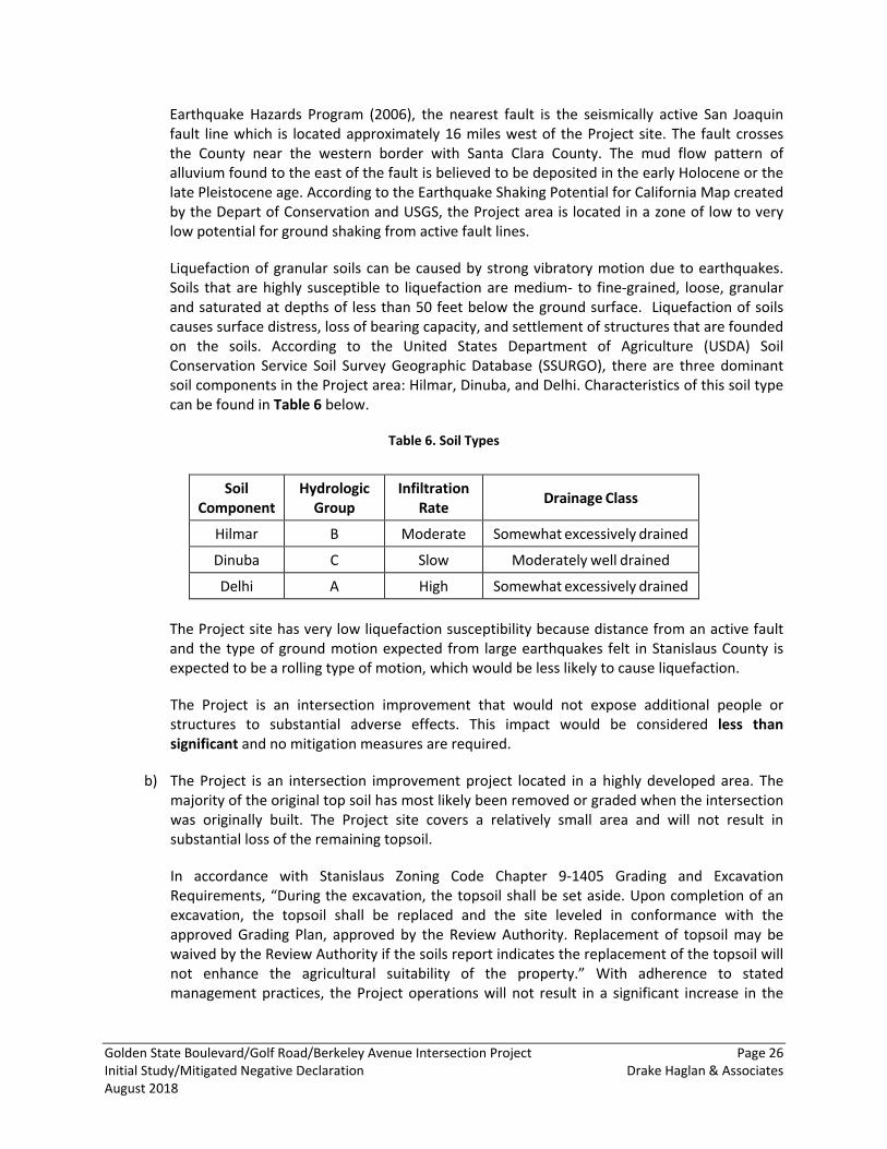
Golden State Boulevard/Golf Road/Berkeley Avenue Intersection Project Page 26 Initial Study/Mitigated Negative Declaration Drake Haglan & Associates August 2018
Earthquake Hazards Program (2006), the nearest fault is the seismically active San Joaquin fault line which is located approximately 16 miles west of the Project site. The fault crosses the County near the western border with Santa Clara County. The mud flow pattern of alluvium found to the east of the fault is believed to be deposited in the early Holocene or the late Pleistocene age. According to the Earthquake Shaking Potential for California Map created by the Depart of Conservation and USGS, the Project area is located in a zone of low to very low potential for ground shaking from active fault lines.
Liquefaction of granular soils can be caused by strong vibratory motion due to earthquakes. Soils that are highly susceptible to liquefaction are medium- to fine-grained, loose, granular and saturated at depths of less than 50 feet below the ground surface. Liquefaction of soils causes surface distress, loss of bearing capacity, and settlement of structures that are founded on the soils. According to the United States Department of Agriculture (USDA) Soil Conservation Service Soil Survey Geographic Database (SSURGO), there are three dominant soil components in the Project area: Hilmar, Dinuba, and Delhi. Characteristics of this soil type can be found in Table 6 below.
Table 6. Soil Types
Soil Component
Hydrologic Group
Infiltration Rate Drainage Class
Hilmar B Moderate Somewhat excessively drained
Dinuba C Slow Moderately well drained
Delhi A High Somewhat excessively drained
The Project site has very low liquefaction susceptibility because distance from an active fault and the type of ground motion expected from large earthquakes felt in Stanislaus County is expected to be a rolling type of motion, which would be less likely to cause liquefaction.
The Project is an intersection improvement that would not expose additional people or structures to substantial adverse effects. This impact would be considered less than significant and no mitigation measures are required.
b) The Project is an intersection improvement project located in a highly developed area. The majority of the original top soil has most likely been removed or graded when the intersection was originally built. The Project site covers a relatively small area and will not result in substantial loss of the remaining topsoil.
In accordance with Stanislaus Zoning Code Chapter 9-1405 Grading and Excavation Requirements, “During the excavation, the topsoil shall be set aside. Upon completion of an excavation, the topsoil shall be replaced and the site leveled in conformance with the approved Grading Plan, approved by the Review Authority. Replacement of topsoil may be waived by the Review Authority if the soils report indicates the replacement of the topsoil will not enhance the agricultural suitability of the property.” With adherence to stated management practices, the Project operations will not result in a significant increase in the
Golden State Boulevard/Golf Road/Berkeley Avenue Intersection Project Page 27 Initial Study/Mitigated Negative Declaration Drake Haglan & Associates August 2018
potential for soil erosion over existing conditions. Potential erosion impacts from construction activities would be less than significant and no mitigation measures are required.
c) According to the California Department of Conservation Landslides Map, the probability of landslides occurring on the Project site is extremely low. The Project site is located in the California Central Valley where the terrain is relatively flat. There are no mountains, hillsides, or natural topographic features surrounding the Project area that could pose a risk of creating a landslide. The impact would be considered to be less than significant and no mitigation measures are required.
d) Expansive soils are those possessing clay particles that react to moisture changes by shrinking (when dry) or swelling (when wet). The extent of shrinking and swelling is influenced by the environment, including the extent of wet or dry cycles and by the amount of clay in the soil. This physical change in the soils can react unfavorably with building foundations, concrete walkways, swimming pools, roadways, and masonry walls. The Project site consists of three soil types: Hilmar, Dinuba, and Delhi. All three soil types are classified as containing predominately sand instead of clay. Therefore, the Project would not expose life or properties to adverse effects associated with expansive soil. The impact would be considered to be less than significant and no mitigation measures are required.
e) The Project does not involve the connection to sewer systems or septic tanks as part of the Project; therefore, there would be no impact.
Golden State Boulevard/Golf Road/Berkeley Avenue Intersection Project Page 28 Initial Study/Mitigated Negative Declaration Drake Haglan & Associates August 2018
Greenhouse Gas Emissions 4.7
Issues (and Supporting Information Sources) Potentially Significant
Impact
Less Than Significant
with Mitigation
Incorporation
Less Than Significant
Impact No Impact
Greenhouse Gas Emissions –Would the project: a) Generate greenhouse gas emissions, either directly or
indirectly, that may have a significant impact on the environment?
b) Conflict with an applicable plan, policy or regulation adopted for the purpose of reducing the emissions of greenhouse gases?
4.7.1 Setting California’s primary legislation for reducing greenhouse gas (GHG) emission is the California Global Warming Solutions Act (Assembly Bill [AB] 32). Agencies that regulate GHG emissions include the SJVAPCD, Caltrans, and the California Air Resources Board. Neither the SJVAPCD, Caltrans, nor ARB have issued clear thresholds on construction-related GHG emissions for CEQA. Likewise, SJVAPCD has not released an adopted set of construction-related BPS for GHG emissions.
4.7.2 Discussion a,b) Since the Project would not add lanes or increase capacity, it would only produce additional
GHG emissions during construction (approximately one year). The Project would not affect long-term GHG emissions in the area or stationary GHG sources.
Construction
Project construction would generate combustion emissions from various sources. During site preparation and construction, GHGs would be emitted from construction equipment and from worker and builder supply vendor vehicles, each of which typically use fossil-based fuels to operate. The combustion of fossil-based fuels creates GHGs such as CO2, CH4, and N2O. Furthermore, CH4 is emitted during the fueling of heavy equipment. Exhaust emissions from on-site demolition and construction activities would vary daily as construction activity levels change. Construction activities would contribute to the total annual GHG emissions in the State. During construction, the Project would minimize potential GHG emissions through implementation of avoidance and minimization measures listed in the Air Quality section. With implementation of these required controls, GHG emissions from construction of the Project would be less than significant and no mitigation measures are required.
Operations
As the Project would not include additional through lanes, the Project would not increase roadway facilities or service capabilities that would induce unplanned growth or remove an existing obstacle to growth. Consequently, the proposed construction Project is considered small, short-term in nature and would not generate substantial air quality (including GHG emission) pollutant concentrations as discussed under the Air Quality section. Since the purpose of the Project is to reduce long-term traffic congestion, there would be no operational impacts

Golden State Boulevard/Golf Road/Berkeley Avenue Intersection Project Page 29 Initial Study/Mitigated Negative Declaration Drake Haglan & Associates August 2018
associated with GHG emissions. Impacts would be considered less than significant and no mitigation measures are required.
4.7.3 Avoidance and Minimization Measures Avoidance and Minimization Measure AIR-1 through AIR-4: Please refer to the Air Quality section.
Golden State Boulevard/Golf Road/Berkeley Avenue Intersection Project Page 30 Initial Study/Mitigated Negative Declaration Drake Haglan & Associates August 2018
Energy 4.8
Issues (Supporting Information Sources) Potentially Significant
Impact
Less Than Significant
with Mitigation
Incorporation
Less Than Significant
Impact No Impact
Energy –Would the Project: a) Result in a substantial increase in overall or per capita
energy consumption?
b) Result in wasteful or unnecessary consumption of energy?
c) Require or result in the construction of new sources of energy supplies or additional energy infrastructure capacity the construction of which could cause significant environmental effects?
d) Conflict with applicable energy efficiency policies or standards?
4.8.1 Setting Transportation-related activities account for approximately half of all the petroleum products consumed in California (Department of Energy, 2004). While state and federal policies, such as the California Low-Emission Vehicle Program and the Federal Energy Policy Act of 1992, are increasing the use of alternative-fuel and low-emission vehicles, the consumption of non-renewable resources, such as fossil-fuels, remains high and points to the need to conserve such energy resources. Both the National Environmental Policy Act (NEPA) [Section 102(2)] and the CEQA Guidelines (Appendix F) require the identification of potentially substantial (significant) energy impacts.
4.8.2 Discussion a-d) The Project would result in temporary use of energy as fuels for construction equipment.
Construction activities are estimated to last approximately one year. The purpose of the Project is to improve regional air quality by upgrading the current LOS at the Golden State Boulevard/Golf Road/Berkeley Avenue intersection. The Project would not be associated with the development of land uses (i.e., residential, commercial, etc.) that would increase the demand for local or regional sources of energy. The use of energy for the construction of the Project is minimal and would not require the construction of new sources of energy or energy infrastructure for implementation of the Project. The Project would also not conflict with any energy efficiency policies or standards. The impact to energy resources would be considered less than significant and no mitigation measures are required.
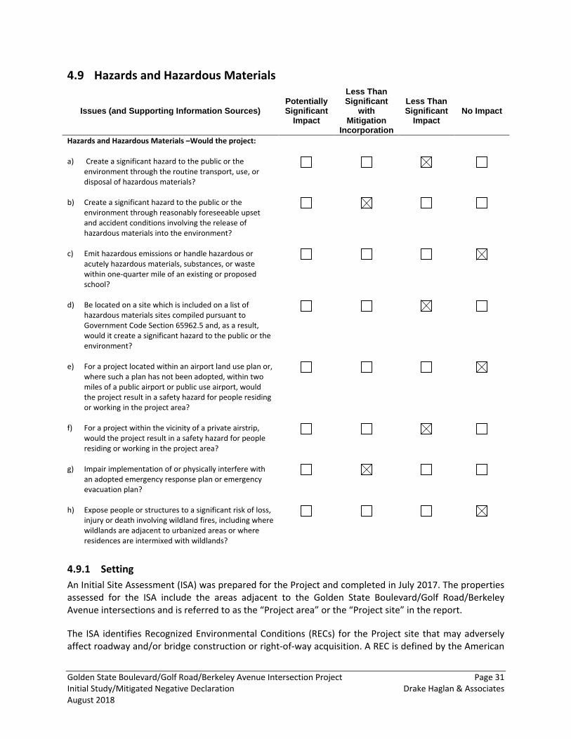
Golden State Boulevard/Golf Road/Berkeley Avenue Intersection Project Page 31 Initial Study/Mitigated Negative Declaration Drake Haglan & Associates August 2018
Hazards and Hazardous Materials 4.9
Issues (and Supporting Information Sources) Potentially Significant
Impact
Less Than Significant
with Mitigation
Incorporation
Less Than Significant
Impact No Impact
Hazards and Hazardous Materials –Would the project: a) Create a significant hazard to the public or the
environment through the routine transport, use, or disposal of hazardous materials?
b) Create a significant hazard to the public or the environment through reasonably foreseeable upset and accident conditions involving the release of hazardous materials into the environment?
c) Emit hazardous emissions or handle hazardous or acutely hazardous materials, substances, or waste within one-quarter mile of an existing or proposed school?
d) Be located on a site which is included on a list of hazardous materials sites compiled pursuant to Government Code Section 65962.5 and, as a result, would it create a significant hazard to the public or the environment?
e) For a project located within an airport land use plan or, where such a plan has not been adopted, within two miles of a public airport or public use airport, would the project result in a safety hazard for people residing or working in the project area?
f) For a project within the vicinity of a private airstrip, would the project result in a safety hazard for people residing or working in the project area?
g) Impair implementation of or physically interfere with an adopted emergency response plan or emergency evacuation plan?
h) Expose people or structures to a significant risk of loss, injury or death involving wildland fires, including where wildlands are adjacent to urbanized areas or where residences are intermixed with wildlands?
4.9.1 Setting An Initial Site Assessment (ISA) was prepared for the Project and completed in July 2017. The properties assessed for the ISA include the areas adjacent to the Golden State Boulevard/Golf Road/Berkeley Avenue intersections and is referred to as the “Project area” or the “Project site” in the report.
The ISA identifies Recognized Environmental Conditions (RECs) for the Project site that may adversely affect roadway and/or bridge construction or right-of-way acquisition. A REC is defined by the American
Golden State Boulevard/Golf Road/Berkeley Avenue Intersection Project Page 32 Initial Study/Mitigated Negative Declaration Drake Haglan & Associates August 2018
Society for Testing and Materials (ASTM) Practice E 1527-05 as: “the presence or likely presence of any hazardous substances or petroleum products in, on, or at a property: (1) due to any release to the environment; (2) under conditions indicative of a release to the environment; or (3) under conditions that pose a material threat of a future release to the environment.”
This ISA was conducted in general conformance with the scope and limitations of the ASTM Practice E 1527-05. This ISA includes a summary of the site reconnaissance conducted on January 26, 2017; a review of environmental databases; and a review of historical data sources. Any exceptions to or deletions from these ASTM practices are described later in this report.
A database report was obtained from Environmental Database Resources, Inc. (EDR) consisting of information compiled from various government records, such as Geotracker, National Priorities List and solid waste information system, for information regarding the Project area. The following potential environmental issues within the Project area and surrounding properties were also discussed:
• The presence of lead-based paint (LBP) due to the age of the existing road; • The presence of aerially deposited lead due to historic deposition of vehicle exhaust
particulates; • The presence of petroleum hydrocarbons, grease, and heavy metals due to adjacent auto
dismantling businesses and the railroad crossing; and • The presence of agricultural chemicals due to historical agricultural practices on adjacent
properties.
Petroleum Hydrocarbons, Grease, Creosote Treated Wood, and Heavy Metals
Based on the results of the records review and reconnaissance, there is the potential for petroleum hydrocarbon, grease, and heavy metals contamination due to the nearby auto dismantling and railroad operations. There are auto dismantling businesses located on either side of Berkeley Avenue and include La Mina Auto Wreckers and Parts 4 Less Auto Dismantling. It has been determined that portions of these parcels would need to be acquired for the Project. Contaminants from dismantled vehicles, such as petroleum hydrocarbons, could be present in the soil. Railroad ties are typically creosote treated timber which could leach into the surrounding soil. Based on the preliminary design, there is a possibility that ground disturbing work would be conducted adjacent to the railroad and therefore contaminated soil may be encountered.
Aerially Deposited Lead and Lead-Based Paint
Aerially Deposited Lead (ADL) is commonly found adjacent to heavily traveled roadways in service prior to 1987 as lead was used as a gasoline additive prior to this time. Based on our review of aerial photos and topographical maps, Golden State Boulevard was historically, and is currently, a major collector route through the County and the City as an alternative route to Highway 99; therefore, historic deposition of vehicle exhaust particulates containing lead may have occurred along the roadway shoulder. The ADL Report conducted for the Project indicated that soils exceeding lead contamination action levels may be encounter during Project construction.
Lead has been used in commercial, residential, roadway, and ceramic paint; in electric batteries and other devises; as a gasoline additive; for weighting; in gunshot; and other purposes. It is recognized as toxic to human health and the environment and is widely regulated in the United States. Structures
Golden State Boulevard/Golf Road/Berkeley Avenue Intersection Project Page 33 Initial Study/Mitigated Negative Declaration Drake Haglan & Associates August 2018
constructed prior to 1978 are presumed to contain LBP unless proven otherwise, although structures constructed after 1978 may also contain LBP. Additionally, pavement striping paint on roadways often contains lead. Painted areas and pavement striping were observed in the Project area; therefore, the potential exists for the roadway within the Project area to contain LBP. Without further testing, the assumption is that the existing paint on roadways would contain concentrations of lead that exceed the threshold values for hazardous waste.
Agricultural Chemicals
The parcels on the southwestern and northeastern sides of Golden State Boulevard were historically used for agricultural production until as recently as 1976. Consequently, there is the potential for the presence of residual environmentally persistent pesticides and/or herbicides in the soil. While the probability of residual environmentally persistent pesticides may be low, they are often detected in soils on properties with a long agricultural history.
4.9.2 Discussion a) Project construction would potentially require the use of various types and quantities of
hazardous materials. Hazardous materials that are typically used during construction include, but are not limited to, hydraulic oil, diesel fuel, grease, lubricants, solvents, and adhesives. Although equipment used during construction activities could contain various hazardous materials, these materials would be used in accordance with the manufacturers specifications and all applicable regulations. Project operations would not involve the routine storage or use hazardous materials. Impacts resulting from the transport, use, or disposal of hazardous materials during construction and operation of the Project would be less than significant and no mitigation measures are required.
b) As stated above, if implemented, the Project construction has the potential to use a variety of hazardous materials. These materials would be stored, handled, and transported per federal, state, and local regulatory requirements. Additionally, an ISA was prepared to support this environmental document which indicated the presence of multiple RECs within the vicinity of the Project site.
During construction, any existing hazardous materials that may be encountered would pose a hazard for construction workers and the environment. Construction workers typically are at the greatest risk for exposure to contaminated materials. Accidents or spills during transport of hazardous materials or wastes could have the potential to expose the public and the environment to these substances.
Implementation of MM HAZ-1, MM HAZ-2, and MM HAZ-3 would be required to ensure there would not be a significant hazard to the public or the environment through reasonably foreseeable upset and accident conditions involving the release of hazardous materials into the environment and would reduce the impact to a less-than-significant level.
c) The Project is located approximately 1-mile northwest from Stanislaus Academy and 1.2 miles east of Cunningham School Headstart and Wakefield Elementary School. While the Project would involve the short-term handling of hazardous materials during construction, the handling and storage of said hazardous materials during construction would comply with all applicable
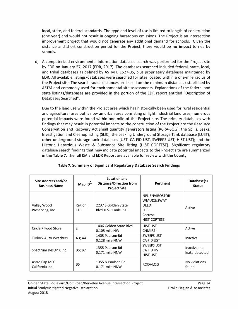
Golden State Boulevard/Golf Road/Berkeley Avenue Intersection Project Page 34 Initial Study/Mitigated Negative Declaration Drake Haglan & Associates August 2018
local, state, and federal standards. The type and level of use is limited to length of construction (one year) and would not result in ongoing hazardous emissions. The Project is an intersection improvement project that would not generate any additional demand for schools. Given the distance and short construction period for the Project, there would be no impact to nearby schools.
d) A computerized environmental information database search was performed for the Project site by EDR on January 27, 2017 (EDR, 2017). The databases searched included federal, state, local, and tribal databases as defined by ASTM E 1527-05, plus proprietary databases maintained by EDR. All available listings/databases were searched for sites located within a one-mile radius of the Project site. The search radius distances are based on the minimum distances established by ASTM and commonly used for environmental site assessments. Explanations of the federal and state listings/databases are provided in the portion of the EDR report entitled "Description of Databases Searched".
Due to the land use within the Project area which has historically been used for rural residential and agricultural uses but is now an urban area consisting of light industrial land uses, numerous potential impacts were found within one mile of the Project site. The primary databases with findings that may result in potential impacts to the construction of the Project are the Resource Conservation and Recovery Act small quantity generators listing (RCRA-SQG); the Spills, Leaks, Investigation and Cleanup listing (SLIC); the Leaking Underground Storage Tank database (LUST); other underground storage tank databases (UST, CA FID UST, SWEEPS UST, HIST UST); and the Historic Hazardous Waste & Substance Site listing (HIST CORTESE). Significant regulatory database search findings that may indicate potential impacts to the Project site are summarized in the Table 7. The full ISA and EDR Report are available for review with the County.
Table 7. Summary of Significant Regulatory Database Search Findings
Site Address and/or Business Name Map ID1
Location and Distance/Direction from
Project Site Pertinent Database(s)
Status
Valley Wood Preserving, Inc.
Region; E18
2237 S Golden State Blvd 0.5- 1 mile SSE
NPL ENVIROSTOR WMUDS/SWAT DEED LDS Cortese HIST CORTESE
Active
Circle K Food Store 2 1406 Golden State Blvd 0.105 mile NW
HIST UST CHMIRS Active
Turlock Auto Wreckers A3; A4 1405 Paulson Rd 0.128 mile NNW
SWEEPS UST CA FID UST Inactive
Spectrum Designs, Inc. B5; B7 1355 Paulson Rd 0.171 mile NNW
SWEEPS UST CA FID UST HIST UST
Inactive; no leaks detected
Astro Cap MFG California Inc B5 1355 N Paulson Rd
0.171 mile NNW RCRA-LQG No violations found
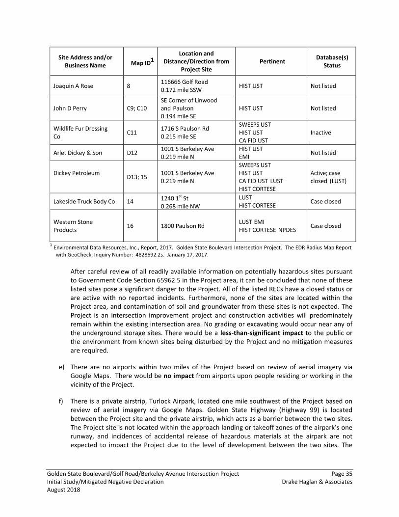
Golden State Boulevard/Golf Road/Berkeley Avenue Intersection Project Page 35 Initial Study/Mitigated Negative Declaration Drake Haglan & Associates August 2018
Site Address and/or Business Name Map ID1
Location and Distance/Direction from
Project Site Pertinent Database(s)
Status
Joaquin A Rose 8 116666 Golf Road 0.172 mile SSW HIST UST Not listed
John D Perry C9; C10 SE Corner of Linwood and Paulson 0.194 mile SE
HIST UST Not listed
Wildlife Fur Dressing Co C11 1716 S Paulson Rd
0.215 mile SE
SWEEPS UST HIST UST CA FID UST
Inactive
Arlet Dickey & Son D12 1001 S Berkeley Ave 0.219 mile N
HIST UST EMI Not listed
Dickey Petroleum D13; 15 1001 S Berkeley Ave
0.219 mile N
SWEEPS UST HIST UST CA FID UST LUST HIST CORTESE
Active; case closed (LUST)
Lakeside Truck Body Co 14 1240 1st St 0.268 mile NW
LUST HIST CORTESE Case closed
Western Stone Products 16 1800 Paulson Rd LUST EMI
HIST CORTESE NPDES Case closed
1 Environmental Data Resources, Inc., Report, 2017. Golden State Boulevard Intersection Project. The EDR Radius Map Report with GeoCheck, Inquiry Number: 4828692.2s. January 17, 2017.
After careful review of all readily available information on potentially hazardous sites pursuant to Government Code Section 65962.5 in the Project area, it can be concluded that none of these listed sites pose a significant danger to the Project. All of the listed RECs have a closed status or are active with no reported incidents. Furthermore, none of the sites are located within the Project area, and contamination of soil and groundwater from these sites is not expected. The Project is an intersection improvement project and construction activities will predominately remain within the existing intersection area. No grading or excavating would occur near any of the underground storage sites. There would be a less-than-significant impact to the public or the environment from known sites being disturbed by the Project and no mitigation measures are required.
e) There are no airports within two miles of the Project based on review of aerial imagery via Google Maps. There would be no impact from airports upon people residing or working in the vicinity of the Project.
f) There is a private airstrip, Turlock Airpark, located one mile southwest of the Project based on review of aerial imagery via Google Maps. Golden State Highway (Highway 99) is located between the Project site and the private airstrip, which acts as a barrier between the two sites. The Project site is not located within the approach landing or takeoff zones of the airpark’s one runway, and incidences of accidental release of hazardous materials at the airpark are not expected to impact the Project due to the level of development between the two sites. The
Golden State Boulevard/Golf Road/Berkeley Avenue Intersection Project Page 36 Initial Study/Mitigated Negative Declaration Drake Haglan & Associates August 2018
Project would have less-than-significant impacts on the private airpark and no mitigation measures are required.
g) The Project would require the removal of the existing Golden State Boulevard/Golf Road/Berkeley Avenue intersection and the construction of a new intersection designed to meet applicable LOS requirements. The Project would also involve the realignment of the Paulson Road/Berkeley Avenue and Golf Road/Frontage Road intersections. Construction of the Project is currently scheduled to start in 2020 and take approximately twelve months to complete. The Project would not require the full closure of any roads on the Project site but may require temporary lane closures and one-way traffic control. With the implementation of MM TRAF-1, discussed later in the document in the Transportation and Traffic section, the impact to emergency response plans and emergency evacuation plans would be less than significant.
h) The area surrounding the Project site consists of agricultural, commercial, industrial, and urban transitional land uses. There are no designated wildlands in the vicinity of the Project, and the Project area is not designated as being located within an area prone to wildfire. The Project is an intersection improvement project that would not expose additional people or structures to the threat of fire. There would be no impact associated with wildland fire threat.
4.9.3 Mitigation Measures MM HAZ-1: Development of a Health and Safety Plan (HASP). A HASP shall be developed for the Project by the contractor selected by the County. The County Public Works Department is responsible for reviewing and approving the HASP. The HASP shall describe appropriate procedures to follow in the event that any contaminated soil or groundwater is encountered during construction activities. Any unknown substances shall be tested, handled, and disposed of in accordance with appropriate federal, state, and local regulations.
MM HAZ-2: Dispose of Soils Contaminated with Aerially-Deposited Lead and Lead Containing Materials. The following actions are recommended for handling and disposal of ADL and lead containing materials:
• The Contractor shall prepare a Lead Compliance Plan prepared by a Certified Industrial Hygienist
and should be implemented prior to the start of construction activities. The grindings (which consist of the roadway material and the yellow and white color traffic stripes) shall be removed and disposed of in accordance with SSP 36-4 (Residue Containing High Lead Concentration Paints). In addition, the Lead Compliance Plan will also contain the following provision to address ADL: SSP 7-1.02K (6)(j)(iii) – Earth Material Containing Lead.
• Removal, disposal, storage, and transportation of materials contaminated with hazardous levels of aerially-deposited lead should be performed in compliance with the Soil Management Agreement for Aerially-deposited Lead-Contaminated Soils between Caltrans and the Department of Toxic Substance Control.
• Building materials associated with paint on asphalt and utilities shall be abated by a California licensed abatement contractor and disposed of as a hazardous waste.
• A California-licensed lead contractor should be required to perform all work that will disturb any LBP as a result of planned or unplanned renovations in the Project area, including the presence of yellow traffic striping and pavement markings that may contain LBP. All such material must be removed and disposed of as a hazardous material in compliance with SSP 14-11.12.
Golden State Boulevard/Golf Road/Berkeley Avenue Intersection Project Page 37 Initial Study/Mitigated Negative Declaration Drake Haglan & Associates August 2018
MM HAZ-3: Dispose of Soils Contaminated with Agricultural Chemicals, Petroleum Hydrocarbons, Creosote Treated Wood, Grease and Heavy Metals. The following actions are recommended for handling and disposal of contaminated soil during the Plans, Specifications & Estimate (PS&E) phase:
• Collective representative soil samples of right-of-way acquisition areas and areas within the direct impact area adjacent to the railroad tracks shall be taken and analyzed by a California laboratory certified by the Environmental Laboratory Accreditation Program.
• Removal, disposal, storage and transportation of contaminated soil shall be performed in compliance with federal and state regulations for hazardous waste.
MM TRAF-1: Please refer to the Transportation and Traffic section.
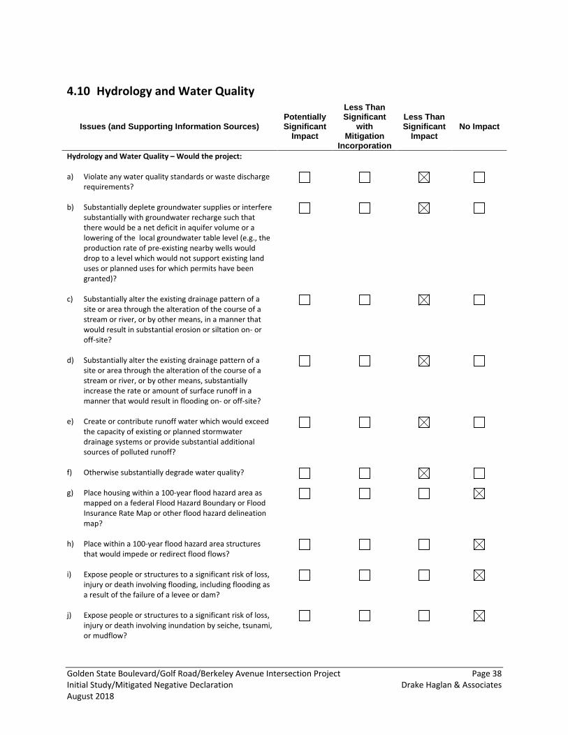
Golden State Boulevard/Golf Road/Berkeley Avenue Intersection Project Page 38 Initial Study/Mitigated Negative Declaration Drake Haglan & Associates August 2018
Hydrology and Water Quality 4.10
Issues (and Supporting Information Sources) Potentially Significant
Impact
Less Than Significant
with Mitigation
Incorporation
Less Than Significant
Impact No Impact
Hydrology and Water Quality – Would the project: a) Violate any water quality standards or waste discharge
requirements?
b) Substantially deplete groundwater supplies or interfere substantially with groundwater recharge such that there would be a net deficit in aquifer volume or a lowering of the local groundwater table level (e.g., the production rate of pre-existing nearby wells would drop to a level which would not support existing land uses or planned uses for which permits have been granted)?
c) Substantially alter the existing drainage pattern of a site or area through the alteration of the course of a stream or river, or by other means, in a manner that would result in substantial erosion or siltation on- or off-site?
d) Substantially alter the existing drainage pattern of a site or area through the alteration of the course of a stream or river, or by other means, substantially increase the rate or amount of surface runoff in a manner that would result in flooding on- or off-site?
e) Create or contribute runoff water which would exceed the capacity of existing or planned stormwater drainage systems or provide substantial additional sources of polluted runoff?
f) Otherwise substantially degrade water quality?
g) Place housing within a 100-year flood hazard area as mapped on a federal Flood Hazard Boundary or Flood Insurance Rate Map or other flood hazard delineation map?
h) Place within a 100-year flood hazard area structures that would impede or redirect flood flows?
i) Expose people or structures to a significant risk of loss, injury or death involving flooding, including flooding as a result of the failure of a levee or dam?
j) Expose people or structures to a significant risk of loss, injury or death involving inundation by seiche, tsunami, or mudflow?
Golden State Boulevard/Golf Road/Berkeley Avenue Intersection Project Page 39 Initial Study/Mitigated Negative Declaration Drake Haglan & Associates August 2018
4.10.1 Setting The Project site is located within the Middle San Joaquin-Lower Merced-Lower Stanislaus watershed within the San Joaquin River Basin. The San Joaquin River Basin covers 15,880 square miles and includes the entire area drained by the San Joaquin River. It includes all watersheds tributary to the San Joaquin River and the Delta south of the Sacramento River and south of the American River watershed. The principal streams in the basin are the San Joaquin River and its larger tributaries: the Cosumnes, Mokelumne, Calaveras, Stanislaus, Tuolumne, Merced, Chowchilla, and Fresno rivers. Major reservoirs and lakes include Pardee, New Hogan, Millerton, McClure, Don Pedro, and New Melones. The terrain at the Project site and surrounding area is generally flat, ranging in elevation from 100 to 105 feet above mean sea level (MSL). Existing storm water drains into basins located along Golden State Boulevard and the UPRR throughout the Project Site. The Project site has a general northeast-to-southwest topographic gradient; therefore, it can be assumed that groundwater within the Project site vicinity also flows in a southwesterly direction.
Stanislaus County Storm Water Management and Discharge Control Ordinance
Stanislaus County implemented the Storm Water Management and Discharge Control Ordinance (Ord. 14.14) to protect and promote the health, safety, and general welfare of the citizens of the County by controlling non-storm water discharges to the storm water conveyance system from spills, dumping, or disposal of material other than storm water and by reducing pollutants in urban storm water discharge to the maximum extent possible. This ordinance establishes measures that any person engaging in activities that may result in pollutants entering the storm water conveyance system shall, to the maximum extent practicable, undertake to reduce the risk of non-storm water discharge and/or pollutant discharge. These measures are as follows:
• Construction o Any person performing construction activities in the County shall prevent pollutants
from entering the storm water conveyance system and comply with all applicable federal, state, and local laws, ordinances, or regulations including, but not limited to, the general permit for storm water discharges associated with construction activity and the County Storm Water Management and Discharge Control Ordinance.
o Any person subject to a Construction Activity NPDES storm water discharge permit shall comply with all provisions of such permit. Proof of compliance with said permit may be required in a form acceptable to the enforcement official prior to, or as a condition of, a subdivision map, site plan, building permit, grading permit, or development or improvement plan, upon inspection of the facility, during any enforcement proceeding or action, or for any other reasonable cause. Prior to issuance of a construction permit or approval of the proposed improvement plans, a copy of the Notice of Intent (NOI) and the SWPPP shall be submitted to the County.
• Development o The enforcement official may require controls as appropriate to minimize the long-term,
post-construction activity discharge of storm water pollutants from new development(s) or modifications to existing development(s). Controls may include source control measures to prevent pollution of storm water and/or treatment controls designed to remove pollutants from storm water.
Golden State Boulevard/Golf Road/Berkeley Avenue Intersection Project Page 40 Initial Study/Mitigated Negative Declaration Drake Haglan & Associates August 2018
• Compliance with Industrial or Construction Activity Storm Water Permit o Any person subject to a State Industrial Activity Storm Water Permit for storm water
discharge shall comply with all provisions of such permit. Proof of compliance with said permit may be required in a form acceptable to the enforcement official upon inspection of the facility, during any enforcement proceeding or action, or for any other reasonable cause.
o Any person subject to a State Construction Activity Storm Water Permit for storm water discharge shall comply with all provisions of such permit. Proof of compliance with said permit may be required in a form acceptable to the enforcement official prior to or as a condition of a subdivision map, site plan, building permit, and development of improvement plan; upon inspection of the facility; during any enforcement proceeding or action; or for any other reasonable cause.
• Compliance with Best Management Practices o Every person undertaking any activity or use of premises that may cause or contribute
to storm water pollution or contamination or illicit discharges shall comply with BMP guidelines or pollution control requirements, including the storage and parking of vehicles, as may be reasonably established by the enforcement official.
4.10.2 Discussion a, f) The Project would improve operational movement for the Golden State Boulevard/Golf
Road/Berkeley Avenue intersections. The Project is located in a highly developed part of the County near the City of Turlock. There is no body of water near the Project location. Vehicles traveling on Golden State Boulevard/Golf Road/Berkeley Avenue are sources of oil, grease, gasoline, heavy metals, and combustion byproducts that serve as potential water pollutants and may contribute to storm water runoff pollution in the storm drains and surrounding soils. In addition, construction materials such as asphalt, concrete, and equipment fluids could be exposed to precipitation and subsequent runoff.
The Project would comply with the NPDES Construction General Permit including preparing and implementing a SWPPP that identifies Project specific BMPs to protect water quality during Project construction. Implementation of Avoidance and Minimization Measures HYD-1 would ensure that Project impacts would be less than significant.
b) The Project site is not actively used for groundwater recharge. The Project does not involve groundwater use. The Project is similar in size and scale as the existing intersection. The Project would not result in a significant amount of new impervious surfaces that would impede shallow groundwater recharge. No wells would be constructed as a result of the Project; and construction activities would not intercept or alter groundwater recharge, discharge, or flow conditions. There would be less-than-significant impact on groundwater resources.
c) The Project would not substantially increase the amount or rate of surface runoff such that it would result in substantial erosion or siltation on- or off-site. Construction activities may expose soils to increased rates of erosion during the clearing and grading phases if conducted during winter, but these activities are short term in nature (twelve months) and added erosion could be prevented through standard BMPs. The Project would have a less-than-significant impact on erosion on- and off-site with implementation of Avoidance and Minimization Measure HYD-1.
Golden State Boulevard/Golf Road/Berkeley Avenue Intersection Project Page 41 Initial Study/Mitigated Negative Declaration Drake Haglan & Associates August 2018
d,e) The Project would not substantially increase the amount or rate of surface runoff such that on or off-site flooding would occur because there will be no incremental increases in impervious surfaces with the Project area. The Project would also not create any additional features or change the surrounding land uses in such a way that would exceed the existing or planned storm water drainage systems, capacities, or provide substantial additional sources of polluted runoff. The Project would have a less-than-significant impact on drainage within the Project area.
g-j) The Project site does not contain a river, creek, stream, or any other body of water. The Project is not located in an area mapped as a flood risk for FEMA based on review of published FEMA Flood Insurance Rate Maps (FEMA 2008). No structures in the Project area are located in or adjacent to a 100-year flood area. The Project is an intersection improvement project that would not include creating additional housing. The Project site is not located near any tidally influenced water bodies nor is it near any large bodies of water that could be affected by a tsunami, seiche, or mudflow. There would be no impact.
4.10.3 Avoidance and Minimization Measures Avoidance and Minimization Measure HYD-1: The County will ensure that the Project contractor complies with the requirements of a NPDES permit from the CVRWQCB. As part of the permit, the contractor would be required to prepare and implement a SWPPP into their construction plans, prior to initiating construction activities, identifying BMPs to be used to avoid or minimize any adverse effects before, during, and after construction to surface waters. The following BMPs will be incorporated into the Project as part of the construction specifications:
• Implement appropriate measures to prevent debris, soil, rock, or other material from entering the water. Use a water truck or other appropriate measures to control dust on applicable access roads, construction areas, and stockpiles.
• Properly dispose of oil or other liquids. • Fuel and maintain vehicles in a specified area that is designed to capture spills. • Fuels and hazardous materials would not be stored on site. • Inspect and maintain vehicles and equipment to prevent the dripping of oil or other fluids. • Schedule construction to avoid the rainy season as much as possible. Ground disturbance
activities are expected to begin in the spring/summer of 2020. If rains are forecasted during construction, additional erosion and sedimentation control measures shall be implemented.
• Maintain sediment and erosion control measures during construction. Inspect the control measures before, during, and after a rain event.
• Train construction workers in storm water pollution prevention practices. • Revegetate disturbed areas in a timely manner to control erosion.
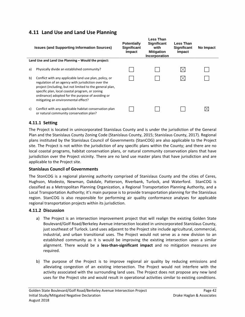
Golden State Boulevard/Golf Road/Berkeley Avenue Intersection Project Page 42 Initial Study/Mitigated Negative Declaration Drake Haglan & Associates August 2018
Land Use and Land Use Planning 4.11
Issues (and Supporting Information Sources) Potentially Significant
Impact
Less Than Significant
with Mitigation
Incorporation
Less Than Significant
Impact No Impact
Land Use and Land Use Planning – Would the project: a) Physically divide an established community?
b) Conflict with any applicable land use plan, policy, or regulation of an agency with jurisdiction over the project (including, but not limited to the general plan, specific plan, local coastal program, or zoning ordinance) adopted for the purpose of avoiding or mitigating an environmental effect?
c) Conflict with any applicable habitat conservation plan or natural community conservation plan?
4.11.1 Setting The Project is located in unincorporated Stanislaus County and is under the jurisdiction of the General Plan and the Stanislaus County Zoning Code (Stanislaus County, 2015; Stanislaus County, 2017). Regional plans instituted by the Stanislaus Council of Governments (StanCOG) are also applicable to the Project site. The Project is not within the jurisdiction of any specific plans within the County; and there are no local coastal programs, habitat conservation plans, or natural community conservation plans that have jurisdiction over the Project vicinity. There are no land use master plans that have jurisdiction and are applicable to the Project site.
Stanislaus Council of Governments The StonCOG is a regional planning authority comprised of Stanislaus County and the cities of Ceres, Hughson, Modesto, Newman, Oakdale, Patterson, Riverbank, Turlock, and Waterford. StanCOG is classified as a Metropolitan Planning Organization, a Regional Transportation Planning Authority, and a Local Transportation Authority; it’s main purpose is to provide transportation planning for the Stanislaus region. StanCOG is also responsible for performing air quality conformance analyses for applicable regional transportation projects within its jurisdiction.
4.11.2 Discussion
a) The Project is an intersection improvement project that will realign the existing Golden State Boulevard/Golf Road/Berkeley Avenue intersection located in unincorporated Stanislaus County, just southeast of Turlock. Land uses adjacent to the Project site include agricultural, commercial, industrial, and urban transitional uses. The Project would not serve as a new division to an established community as it is would be improving the existing intersection upon a similar alignment. There would be a less-than-significant impact and no mitigation measures are required.
b) The purpose of the Project is to improve regional air quality by reducing emissions and alleviating congestion of an existing intersection. The Project would not interfere with the activity associated with the surrounding land uses. The Project does not propose any new land uses for the Project site and would result in operational activities similar to existing conditions.
Golden State Boulevard/Golf Road/Berkeley Avenue Intersection Project Page 43 Initial Study/Mitigated Negative Declaration Drake Haglan & Associates August 2018
Additionally, the Project would not result in any land use conflicts. The Project would not conflict with any applicable land use plan, policy, or regulations. There would be a less-than-significant impact and no mitigation measures are required.
c) The Project site is not within the jurisdiction of an adopted Habitat Conservation Plan or Natural Community Conservation Plan. Therefore, Project implementation would not conflict with the provisions of an approved local, regional, or state habitat conservation plan. No impact would occur.
Golden State Boulevard/Golf Road/Berkeley Avenue Intersection Project Page 44 Initial Study/Mitigated Negative Declaration Drake Haglan & Associates August 2018
Mineral Resources 4.12
Issues (and Supporting Information Sources) Potentially Significant
Impact
Less Than Significant
with Mitigation
Incorporation
Less Than Significant
Impact No Impact
Mineral Resources – Would the project: a) Result in the loss of availability of a known mineral
resource that would be of value to the region and the residents of the state?
b) Result in the loss of availability of a locally important mineral resource recovery site delineated on a local general plan, specific plan or other land use plan?
4.12.1 Setting The California Surface Mining and Reclamation Act (SMARA) was enacted by the California legislature to regulate activities related to mineral resource extraction. The act requires the prevention of adverse environmental effects caused by mining, the reclamation of mined lands for alternative land uses, and the elimination of public health and safety hazards from the effects of mining activities. The California Geological Survey (formerly California Division of Mines and Geology) classifies the regional significance of mineral resources in accordance with SMARA. Mineral Resource Zones (MRZs) have been designated to indicate the significance of mineral deposits. A classification of MRZ-1 signifies an area where adequate information indicates that no significant mineral deposits are present, or where it is judged that little likelihood exists for their presence; MRZ-2 signifies an area where adequate information indicates that significant mineral deposits are present, or where it is judged that a high likelihood for their presence exists; and MRZ-3 signifies an area where the significance of mineral deposits cannot be evaluated from existing data. These designations are intended to preserve known mineral resources for future mining and to prevent encroachment of urban development that would compromise the resource’s value.
According to the California Department of Conservation (2015a), there are areas within the County that contain known significant mineral deposits (MRZ-2a). These deposits are mostly composed of aggregate minerals which are commonly used for development and concrete production. The Project site is not located in an area of the County that has been determined to contain or potentially contain significant mineral deposits.
4.12.2 Discussion a) The Project is an intersection improvement project in a highly developed urban area. There are
no current or planned mining operations in the area. Construction activities would be temporary and operation of the Project would not conflict with or limit access to mineral resources. There would be no impact to the availability of known minerals.
b) Land use within the Project area consists of agricultural, commercial, industrial, and urban transitional uses. The Project is not located near a mineral resource recovery site delineated on any local general plan, specific plan or other land use plan. There would be no impact.
Golden State Boulevard/Golf Road/Berkeley Avenue Intersection Project Page 45 Initial Study/Mitigated Negative Declaration Drake Haglan & Associates August 2018
Noise 4.13
Issues (and Supporting Information Sources): Potentially Significant
Impact
Less Than Significant
with Mitigation
Incorporation
Less Than Significant
Impact No Impact
Noise – Would the project: a) Result in exposure of persons to, or generation of,
noise levels in excess of standards established in the local general plan or noise ordinance, or applicable standards of other agencies?
b) Result in exposure of persons to, or generation of, excessive groundborne vibration or groundborne noise levels?
c) Result in a substantial permanent increase in ambient noise levels in the project vicinity above levels existing without the project?
d) Result in a substantial temporary or periodic increase in ambient noise levels in the project vicinity above levels existing without the project?
e) For a project located within an airport land use plan area, or, where such a plan has not been adopted, in an area within two miles of a public airport or public use airport, would the project expose people residing or working in the area to excessive noise levels?
f) For a project located in the vicinity of a private airstrip, would the project expose people residing or working in the project area to excessive noise levels?
4.13.1 Setting Noise is defined as unwanted sound, and thus is a subjective reaction to characteristics of a physical phenomenon. A frequency weighting measure that simulates human perception is commonly used to describe noise environments and to assess impacts on noise-sensitive areas. It has been found that A-weighting of sound levels best reflects the human ear's reduced sensitivity to low frequencies and correlates well with human perceptions of the annoying aspects of noise. The A-weighted decibel scale (dBA) is cited in most noise criteria. The decibel notation used for sound levels describes a logarithmic relationship of acoustical energy, for example, a doubling of acoustical energy results in an increase of 3 dB, which is considered barely perceptible. A ten-fold increase in acoustical energy equals a 10 dB change, which is subjectively like a doubling of loudness. Table 8, Typical Noise Levels, identifies decibel levels for common sounds heard in the environment.
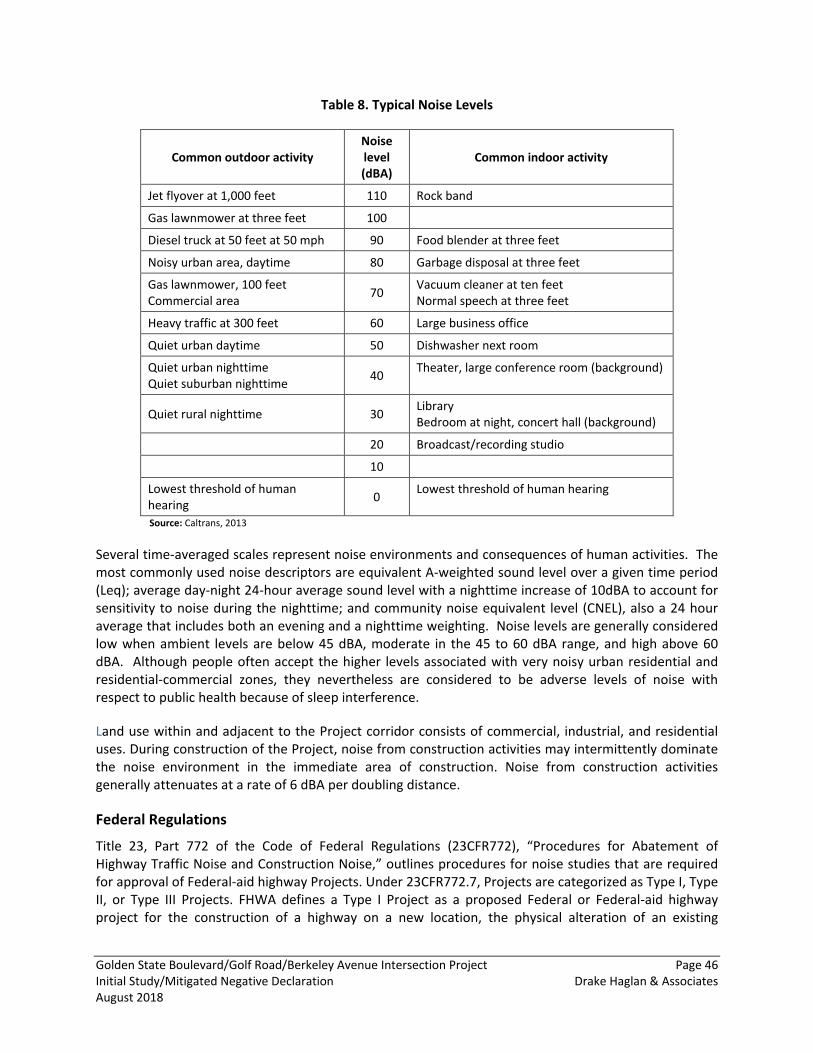
Golden State Boulevard/Golf Road/Berkeley Avenue Intersection Project Page 46 Initial Study/Mitigated Negative Declaration Drake Haglan & Associates August 2018
Table 8. Typical Noise Levels
Common outdoor activity Noise level (dBA)
Common indoor activity
Jet flyover at 1,000 feet 110 Rock band
Gas lawnmower at three feet 100
Diesel truck at 50 feet at 50 mph 90 Food blender at three feet
Noisy urban area, daytime 80 Garbage disposal at three feet
Gas lawnmower, 100 feet Commercial area 70 Vacuum cleaner at ten feet
Normal speech at three feet
Heavy traffic at 300 feet 60 Large business office
Quiet urban daytime 50 Dishwasher next room
Quiet urban nighttime Quiet suburban nighttime 40 Theater, large conference room (background)
Quiet rural nighttime 30 Library Bedroom at night, concert hall (background)
20 Broadcast/recording studio
10
Lowest threshold of human hearing 0 Lowest threshold of human hearing
Source: Caltrans, 2013
Several time-averaged scales represent noise environments and consequences of human activities. The most commonly used noise descriptors are equivalent A-weighted sound level over a given time period (Leq); average day-night 24-hour average sound level with a nighttime increase of 10dBA to account for sensitivity to noise during the nighttime; and community noise equivalent level (CNEL), also a 24 hour average that includes both an evening and a nighttime weighting. Noise levels are generally considered low when ambient levels are below 45 dBA, moderate in the 45 to 60 dBA range, and high above 60 dBA. Although people often accept the higher levels associated with very noisy urban residential and residential-commercial zones, they nevertheless are considered to be adverse levels of noise with respect to public health because of sleep interference.
Land use within and adjacent to the Project corridor consists of commercial, industrial, and residential uses. During construction of the Project, noise from construction activities may intermittently dominate the noise environment in the immediate area of construction. Noise from construction activities generally attenuates at a rate of 6 dBA per doubling distance.
Federal Regulations
Title 23, Part 772 of the Code of Federal Regulations (23CFR772), “Procedures for Abatement of Highway Traffic Noise and Construction Noise,” outlines procedures for noise studies that are required for approval of Federal-aid highway Projects. Under 23CFR772.7, Projects are categorized as Type I, Type II, or Type III Projects. FHWA defines a Type I Project as a proposed Federal or Federal-aid highway project for the construction of a highway on a new location, the physical alteration of an existing
Golden State Boulevard/Golf Road/Berkeley Avenue Intersection Project Page 47 Initial Study/Mitigated Negative Declaration Drake Haglan & Associates August 2018
highway where there is either a substantial horizontal or substantial vertical alteration. A Type II Project involves construction of noise abatement on an existing highway with no changes to highway capacity or alignment. A Type III Project is a project that does not meet the classifications of a Type I or Type II Project. Type III Projects do not require a noise analysis.
The referenced Project meets the criteria for a Type III Project established in 23 CFR 772. The Project is classified as 771.117 (c)(27) Highway safety or traffic operations improvement projects, including the installation of ramp metering control devices and lighting. Therefore, the Project requires no analysis for highway traffic noise impacts. Type III Projects do not involve added capacity, construction of new through lanes or auxiliary lanes, changes in the horizontal or vertical alignment of the roadway, or exposure of noise sensitive land uses to a new or existing highway noise source. DHA acknowledges that a noise analysis is required if changes to the Project result in reclassification to a Type I Project.
State Regulations
Regulation 23 CFR 772 requires that construction noise impacts be identified but does not specify specific methods or abatement criteria for evaluating construction noise. Section 14-8.02, Noise Control, of Caltrans standard specifications provides information that can be considered in determining whether construction would result in adverse noise impacts. The specification states:
• Do not exceed 86 dBA at 50 feet from the job site activities from 9 p.m. to 6 a.m. • Equip an internal combustion engine with the manufacturer-recommended muffler. Do not
operate an internal combustion engine on the job site without the appropriate muffler.
If adverse construction noise impacts are anticipated, Project plans and specifications should identify abatement measures that would minimize or eliminate adverse construction noise impacts to the community. In determining the feasibility of construction noise abatement, Caltrans will consider the benefits achieved and the overall adverse social, economic, and environmental effects and the costs of the construction noise abatement measures.
Stanislaus County Noise Regulations
Policy 2 of the Stanislaus County General Plan Noise Elements states that it is the policy of the County to develop and implement effective measures to abate and avoid excessive noise exposure in the unincorporated areas of the County by requiring that effective noise mitigation measures be incorporated into the design of new noise generating and new noise sensitive land uses.
New development of noise-sensitive land uses will not be permitted in noise-impacted areas unless effective mitigation measures are incorporated into the Project design to reduce noise levels to the following levels:
• For transportation noise sources such as traffic on public roadways, railroads, and airports, 60 Ldn (or CNEL) or less in outdoor activity areas of single family residences, 65 Ldn (or CNEL) or less in community outdoor space for multi-family residences, and 45 Ldn (or CNEL) or less within noise sensitive interior spaces. Where it is not possible to reduce exterior noise due to these sources to the prescribed level using a practical application of the best available noise-reduction technology, an exterior noise level of up to 65 Ldn (or CNEL) will be allowed. Under no
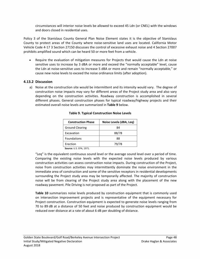
Golden State Boulevard/Golf Road/Berkeley Avenue Intersection Project Page 48 Initial Study/Mitigated Negative Declaration Drake Haglan & Associates August 2018
circumstances will interior noise levels be allowed to exceed 45 Ldn (or CNEL) with the windows and doors closed in residential uses.
Policy 3 of the Stanislaus County General Plan Noise Element states it is the objective of Stanislaus County to protect areas of the County where noise-sensitive land uses are located. California Motor Vehicle Code 4-17 3 Section 27150 discusses the control of excessive exhaust noise and 4 Section 27007 prohibits amplified sound which can be heard 50 or more feet from a vehicle.
• Require the evaluation of mitigation measures for Projects that would cause the Ldn at noise sensitive uses to increase by 3 dBA or more and exceed the “normally acceptable” level, cause the Ldn at noise-sensitive uses to increase 5 dBA or more and remain “normally acceptable,” or cause new noise levels to exceed the noise ordinance limits (after adoption).
4.13.2 Discussion a) Noise at the construction site would be intermittent and its intensity would vary. The degree of
construction noise impacts may vary for different areas of the Project study area and also vary depending on the construction activities. Roadway construction is accomplished in several different phases. General construction phases for typical roadway/highway projects and their estimated overall noise levels are summarized in Table 9 below.
Table 9. Typical Construction Noise Levels
Construction Phase Noise Levela (dBA, Leq)
Ground Clearing 84
Excavation 88/78
Foundations 88
Erection 79/78 Source: U.S. EPA, 1971.
“Leq” is the equivalent continuous sound level or the average sound level over a period of time. Comparing the existing noise levels with the expected noise levels produced by various construction activities can assess construction noise impacts. During construction of the Project, noise from construction activities may intermittently dominate the noise environment in the immediate area of construction and some of the sensitive receptors in residential developments surrounding the Project study area may be temporarily affected. The majority of construction noise will be from clearing of the Project study area along with the placement of the new roadway pavement. Pile Driving is not proposed as part of the Project.
Table 10 summarizes noise levels produced by construction equipment that is commonly used on intersection improvement projects and is representative of the equipment necessary for Project construction. Construction equipment is expected to generate noise levels ranging from 70 to 89 dB at a distance of 50 feet and noise produced by construction equipment would be reduced over distance at a rate of about 6 dB per doubling of distance.
Golden State Boulevard/Golf Road/Berkeley Avenue Intersection Project Page 49 Initial Study/Mitigated Negative Declaration Drake Haglan & Associates August 2018
Table 10. Typical Noise Levels from Construction Equipment
Construction Equipment Noise Level (dBA, Leq at 50 feet)
Scrapers 85
Bulldozers 85
Heavy Trucks 85
Backhoe 80
Pneumatic Tools 85
Concrete Pump 82 Source: HMM&H, 2013
No adverse noise impacts from construction are anticipated because construction would be conducted in accordance with Standard Specification 14-8.02, SSP 14-8.02 applicable local noise standards, and control measures discussed below. Construction noise would be short-term, intermittent, and overshadowed by local traffic noise. Construction operations are anticipated during the day (Monday to Saturday, 7:00 AM to 7:00 PM). This impact would be less than significant.
The Project would have no long-term effects on noise levels because the Project would not increase capacity along the roadway. Once construction is completed, noise levels would return to levels similar to the existing noise environment.
b) There are several different methods that are used to quantify vibration. The threshold of perception for humans is around 65 VdB, and human response to vibration is not usually significant unless the vibration exceeds 70 VdB. Rapid transit or light rail systems typically generate vibration levels of 70 VdB or more near their tracks. On the other hand, buses and trucks rarely create vibration that exceeds 70 VdB unless there are bumps in the road (FTA, 2006).
Equipment associated with high vibration levels (pile drivers) will not be used for construction of the Project. Construction of the Project would use bulldozers and other heavy tracked construction equipment, which may generate a ground-borne vibration level of 90 VdB at 50 feet from source. The majority of construction noise would be from clearing the Project work site along with placement of the new roadway pavement. The nearest sensitive receptor is located 150 feet from construction equipment and would experience vibration levels above the 70 VdB threshold. With the implementation of Avoidance and Minimization Measure NO-1, the Project would have a less-than-significant impact.
c) The Project would establish intersection improvements at the Golden State Boulevard/Golf Road, Paulson Road/Berkeley Avenue, and 1st Street/Golf Road intersections. Based on the existing traffic demands, future traffic demands, and proposed improvements, the Project would have no long-term effects on noise levels. According to the 2040 design-year traffic noise modeling results for the Project, noise levels range from 54 to 63 dBA Leq. Noise levels for the design-year under the Project are not expected to increase over design-year 2040 No-Build noise levels. Therefore, noise abatement and mitigation measures are not required. There would be less-than-significant impact to long-term noise levels.
Golden State Boulevard/Golf Road/Berkeley Avenue Intersection Project Page 50 Initial Study/Mitigated Negative Declaration Drake Haglan & Associates August 2018
d) During construction, the Project would temporarily increase ambient noise levels in the Project vicinity. See the discussion regarding construction noise under a) above. This impact would be less than significant with implementation of Avoidance and Minimization Measure NO-1.
e) There are no public airports within a two-mile radius of the Project. There would be no impact from airports upon people residing or working in the vicinity of the Project.
f) There is a private airstrip, Turlock Airpark, located one mile southwest of the Project. Golden State Boulevard (Highway 99) is located between the Project site and the private airstrip; therefore, noise levels from the highway already dominate the surrounding area. The Project is not located in the approach or takeoff zone for the airpark. This impact would be less than significant.
4.13.3 Avoidance and Minimization Measures Avoidance and Minimization Measure No-1: Reduce Elevated Noise Level during Construction. No adverse noise impacts from construction are anticipated because construction would be conducted in accordance with Caltrans Standard Specifications Section 14-8.02, 42-1.02. Construction noise would be short-term and intermittent. Construction operations are anticipated during daylight hours only (Monday to Friday, 7:00 AM to 7:00 PM). The following control measures shall be implemented in order to minimize noise and vibration disturbances during periods of construction.
• Use equipment with regulatory approved or meter muffling devices and ensure that all equipment items have the manufacturers’ recommended noise abatement measures, such as mufflers, engine enclosures, and engine vibration isolators intact and operational. Newer equipment will generally be quieter in operation than older equipment. All construction equipment should be inspected at periodic intervals to ensure proper maintenance and presence of noise control devices (e.g., mufflers and shrouding, etc.).
• Turn off idling equipment.
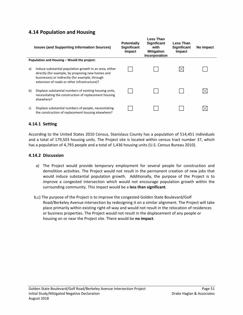
Golden State Boulevard/Golf Road/Berkeley Avenue Intersection Project Page 51 Initial Study/Mitigated Negative Declaration Drake Haglan & Associates August 2018
Population and Housing 4.14
Issues (and Supporting Information Sources) Potentially Significant
Impact
Less Than Significant
with Mitigation
Incorporation
Less Than Significant
Impact No Impact
Population and Housing – Would the project: a) Induce substantial population growth in an area, either
directly (for example, by proposing new homes and businesses) or indirectly (for example, through extension of roads or other infrastructure)?
b) Displace substantial numbers of existing housing units, necessitating the construction of replacement housing elsewhere?
c) Displace substantial numbers of people, necessitating the construction of replacement housing elsewhere?
4.14.1 Setting
According to the United States 2010 Census, Stanislaus County has a population of 514,451 individuals and a total of 179,503 housing units. The Project site is located within census tract number 37, which has a population of 4,793 people and a total of 1,436 housing units (U.S. Census Bureau 2010).
4.14.2 Discussion
a) The Project would provide temporary employment for several people for construction and demolition activities. The Project would not result in the permanent creation of new jobs that would induce substantial population growth. Additionally, the purpose of the Project is to improve a congested intersection which would not encourage population growth within the surrounding community. This impact would be a less than significant.
b,c) The purpose of the Project is to improve the congested Golden State Boulevard/Golf Road/Berkeley Avenue intersection by redesigning it on a similar alignment. The Project will take place primarily within existing right-of-way and would not result in the relocation of residences or business properties. The Project would not result in the displacement of any people or housing on or near the Project site. There would be no impact.
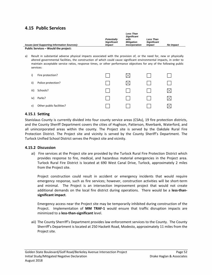
Golden State Boulevard/Golf Road/Berkeley Avenue Intersection Project Page 52 Initial Study/Mitigated Negative Declaration Drake Haglan & Associates August 2018
Public Services 4.15
Issues (and Supporting Information Sources): Potentially Significant Impact
Less Than Significant with Mitigation Incorporation
Less Than Significant Impact No Impact
Public Services – Would the project: a) Result in substantial adverse physical impacts associated with the provision of, or the need for, new or physically
altered governmental facilities, the construction of which could cause significant environmental impacts, in order to maintain acceptable service ratios, response times, or other performance objectives for any of the following public services: i) Fire protection?
ii) Police protection?
iii) Schools?
iv) Parks?
v) Other public facilities?
4.15.1 Setting Stanislaus County is currently divided into four county service areas (CSAs), 19 fire protection districts, and the County Sheriff Department covers the cities of Hughson, Patterson, Riverbank, Waterford, and all unincorporated areas within the county. The Project site is served by the Oakdale Rural Fire Protection District. The Project site and vicinity is served by the County Sheriff’s Department. The Turlock Unified School District serves the Project site and vicinity.
4.15.2 Discussion ai) Fire services at the Project site are provided by the Turlock Rural Fire Protection District which
provides response to fire, medical, and hazardous material emergencies in the Project area. Turlock Rural Fire District is located at 690 West Canal Drive, Turlock, approximately 2 miles from the Project site.
Project construction could result in accident or emergency incidents that would require emergency response, such as fire services; however, construction activities will be short-term and minimal. The Project is an intersection improvement project that would not create additional demands on the local fire district during operations. There would be a less-than-significant impact.
Emergency access near the Project site may be temporarily inhibited during construction of the Project. Implementation of MM TRAF-1 would ensure that traffic disruption impacts are minimized to a less-than-significant level.
aii) The County Sherriff’s Department provides law enforcement services to the County. The County Sherriff’s Department is located at 250 Hackett Road, Modesto, approximately 11 miles from the Project site.
Golden State Boulevard/Golf Road/Berkeley Avenue Intersection Project Page 53 Initial Study/Mitigated Negative Declaration Drake Haglan & Associates August 2018
Construction of the Project may result in accident or emergency incidents that would require police services; however, construction activities will be short-term and minimal. The Project is an intersection improvement project that would not create additional demands on the local police district during operations.
Emergency access to the vicinity of the Project site may be temporarily inhibited during construction of the Project. Implementation of MM TRAF-1 would ensure that traffic disruption impacts are minimized to a less-than-significant level.
aiii) The Project is located approximately 0.5 miles northwest from Stanislaus Academy, 1.1 miles south of Turlock High School and Julien Elementary School, and 1.2 miles east of Cunningham Elementary School and Wakefield Elementary School. The Project is an intersection improvement project that would not generate any additional demand for schools. The Project site is located in the Cunningham and Julien Elementary School enrollment areas, as well as the Turlock High School attendance area. The Project would have no impact to schools in the area.
aiv) The Project is located in a rural area with no parks in or adjacent to the Project site. The nearest parks to the Project site include Sunnyview Park, located approximately 0.5 miles north, and Tot Lot, located approximately 0.75 miles west. The Project would have no impact on public parks.
av) The Project would have no impact on any other public services, such as the County administrative services.
4.15.3 Mitigation Measures MM TRAF-1: Please refer to the Transportation and Traffic section.
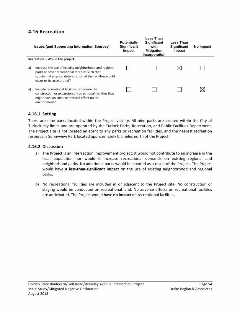
Golden State Boulevard/Golf Road/Berkeley Avenue Intersection Project Page 54 Initial Study/Mitigated Negative Declaration Drake Haglan & Associates August 2018
Recreation 4.16
Issues (and Supporting Information Sources) Potentially Significant
Impact
Less Than Significant
with Mitigation
Incorporation
Less Than Significant
Impact No Impact
Recreation – Would the project: a) Increase the use of existing neighborhood and regional
parks or other recreational facilities such that substantial physical deterioration of the facilities would occur or be accelerated?
a) Include recreational facilities or require the construction or expansion of recreational facilities that might have an adverse physical effect on the environment?
4.16.1 Setting There are nine parks located within the Project vicinity. All nine parks are located within the City of Turlock city limits and are operated by the Turlock Parks, Recreation, and Public Facilities Department. The Project site is not located adjacent to any parks or recreation facilities, and the nearest recreation resource is Sunnyview Park located approximately 0.5 miles north of the Project.
4.16.2 Discussion a) The Project is an intersection improvement project; it would not contribute to an increase in the
local population nor would it increase recreational demands on existing regional and neighborhood parks. No additional parks would be created as a result of the Project. The Project would have a less-than-significant impact on the use of existing neighborhood and regional parks.
b) No recreational facilities are included in or adjacent to the Project site. No construction or staging would be conducted on recreational land. No adverse effects on recreational facilities are anticipated. The Project would have no impact on recreational facilities.
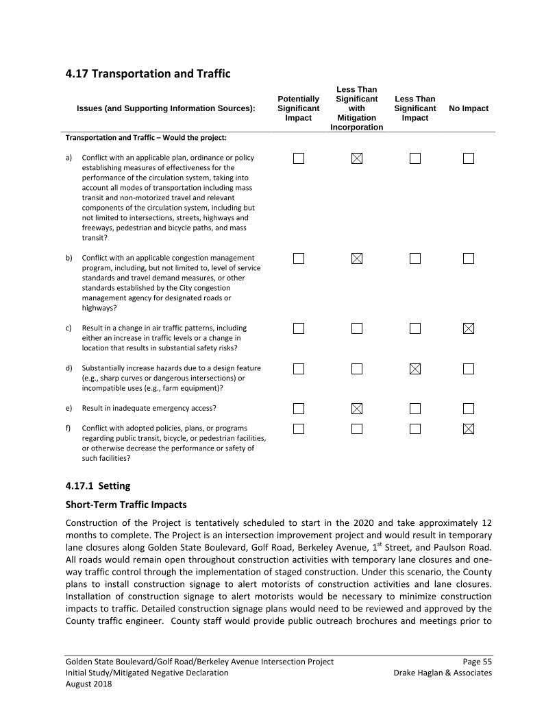
Golden State Boulevard/Golf Road/Berkeley Avenue Intersection Project Page 55 Initial Study/Mitigated Negative Declaration Drake Haglan & Associates August 2018
Transportation and Traffic 4.17
Issues (and Supporting Information Sources): Potentially Significant
Impact
Less Than Significant
with Mitigation
Incorporation
Less Than Significant
Impact No Impact
Transportation and Traffic – Would the project: a) Conflict with an applicable plan, ordinance or policy
establishing measures of effectiveness for the performance of the circulation system, taking into account all modes of transportation including mass transit and non-motorized travel and relevant components of the circulation system, including but not limited to intersections, streets, highways and freeways, pedestrian and bicycle paths, and mass transit?
b) Conflict with an applicable congestion management program, including, but not limited to, level of service standards and travel demand measures, or other standards established by the City congestion management agency for designated roads or highways?
c) Result in a change in air traffic patterns, including either an increase in traffic levels or a change in location that results in substantial safety risks?
d) Substantially increase hazards due to a design feature (e.g., sharp curves or dangerous intersections) or incompatible uses (e.g., farm equipment)?
e) Result in inadequate emergency access?
f) Conflict with adopted policies, plans, or programs regarding public transit, bicycle, or pedestrian facilities, or otherwise decrease the performance or safety of such facilities?
4.17.1 Setting
Short-Term Traffic Impacts
Construction of the Project is tentatively scheduled to start in the 2020 and take approximately 12 months to complete. The Project is an intersection improvement project and would result in temporary lane closures along Golden State Boulevard, Golf Road, Berkeley Avenue, 1st Street, and Paulson Road. All roads would remain open throughout construction activities with temporary lane closures and one-way traffic control through the implementation of staged construction. Under this scenario, the County plans to install construction signage to alert motorists of construction activities and lane closures. Installation of construction signage to alert motorists would be necessary to minimize construction impacts to traffic. Detailed construction signage plans would need to be reviewed and approved by the County traffic engineer. County staff would provide public outreach brochures and meetings prior to
Golden State Boulevard/Golf Road/Berkeley Avenue Intersection Project Page 56 Initial Study/Mitigated Negative Declaration Drake Haglan & Associates August 2018
construction to keep residents informed of the Project. Emergency vehicle access would be maintained at all times.
Long-Term Impacts
The Project is an intersection improvement project that would not increase or decrease future traffic capacity and would result in minimal long-term impacts to traffic circulation in the area. Roadway users would continue to be able to access the intersection from Golden State Boulevard, Golf Road, Berkeley Avenue, and Paulson Road by motor vehicle, bicycle, or on foot following construction. The Project would restrict access along South 1st Street by constructing a right-in/right-out intersection where South 1st Street terminates at Golf Road. The right-in/right-out intersection at South 1st Street and Golf Road would include a raised concrete median that would restrict southbound traffic along South 1st Street from making a left turn onto Golf Road, and northbound traffic along Golf Road from making a direct left turn onto South 1st street. Northbound traffic along Golf Road would still be able to access northbound South 1st Street by performing a U-turn at the proposed signalized Golden State Boulevard/Golf Road intersection, located 100 feet to the northeast of the proposed right-in/right-out intersection. Access to Golden State Boulevard from South 1st Street would be maintained through the implementation of a right-in/right-out access located along Golden State Boulevard, located approximately 500 feet northwest of the intersection of Golf Road and South 1st Street.
4.17.2 Discussion a,b) The purpose of the Project is to improve regional air quality by reducing emissions and
alleviating congestion. The Project would achieve this by redesigning the Golden State Boulevard/Golf Road/Berkeley Avenue intersection, Berkeley Avenue/Paulson Road intersection, and 1st Street/Golf Road intersection. The Project would not create additional lanes, so the average daily traffic volume is expected to be consistent with current volumes on the existing roadways. Minor short-term traffic-related impacts are anticipated during construction of the Project. All roads would remain open throughout construction activities with temporary lane closures and one-way traffic control to be implemented when necessary. Therefore, the overall impact due to the detour would be minor.
The Project is anticipated to create minor long-term impacts to traffic circulation in the area, as the Project will not increase roadway capacity. The Project would alter access along South 1st Street by constructing a right-in/right-out intersection where South 1st Street terminates at Golf Road. The right-in/right-out intersection at South 1st Street and Golf Road would include a raised concrete median that would restrict southbound traffic along South 1st Street from making a left turn onto Golf Road, and northbound traffic along Golf Road from making a direct left turn onto South 1st street. Northbound traffic along Golf Road would still be able to access northbound South 1st Street by performing a U-turn at the proposed signalized Golden State Boulevard/Golf Road intersection, located 100 feet to the northeast of the proposed right-in/right-out intersection. The Project would construct a right-in, right-out access point 500 feet southwest of the Golden State Boulevard/Golf Road/Berkeley Avenue intersection to maintain access to the intersection from South 1st Street. This change is considered to be a minor long-term impact to traffic circulation in the Project area as access to nearby roads would be maintained through traffic control measures and a right-in/right-out access point along Golden State Boulevard.
Golden State Boulevard/Golf Road/Berkeley Avenue Intersection Project Page 57 Initial Study/Mitigated Negative Declaration Drake Haglan & Associates August 2018
The Project would not conflict with any plan or policy established for measuring the performance of the circulation system with the implementation of MM TRAF-1. With MM TRAF-1, the Project would have a less-than-significant impact to level of service along Golden State Boulevard, Golf Road, Berkeley Avenue, South 1st Street, or Paulson Road.
c) The Project does not include structures or uses that would affect air traffic patterns, nor is a public airport located in proximity to the Project site. The Turlock Airpark is located approximately one mile southwest of the Project site, but the Project is not located in the approach or takeoff zone of this facility. Therefore, the Project would not result in substantial safety risks related to air traffic and would have no impact.
d) One of the primary purposes of the Project is to improve regional air quality by upgrading the current LOS at the Golden State Boulevard/Golf Road/Berkeley Avenue intersection and reducing current long vehicle idling times. The Project would convert the un-signalized intersections of Golden State Boulevard and Golf Road into one consolidated four-legged signalized intersection. Additionally, the Project would widen and convert the 2-way stop controlled intersection of Paulson Road and Berkeley Avenue to a signalized intersection to improve sight distances, safety, and LOS of this intersection. The Project would alter access along South 1st Street at Golf Road by constructing a right-in/right-out intersection but would maintain access to nearby roads through traffic control measures and the implementation of a right-in/right-out access along Golden State Boulevard. Traffic hazards would not be increased as a result of the Project. There would be less-than-significant impacts associated with increased hazards due to design features.
e) Traffic congestion and delays can occur during construction and can result in an adverse effect; however, these adverse effects can be avoided through standard construction period traffic management planning that includes timely notification of any road closures and detours to police and fire departments and other emergency service providers. Implementation of MM TRAF-1 would ensure that traffic disruption impacts are minimized to a less-than-significant level.
f) The Project would increase pedestrian and bicyclist safety at the Project site by realigning the Golden State Boulevard/Golf Road/ Berkeley Avenue, Berkeley Avenue/Paulson Road, and South 1st Street/Golf Road intersections. The Project would not conflict with adopted policies, plans, or programs supporting alternative transportation. There would be no impact.
4.17.3 Mitigation Measures MM TRAF-1: Implement Standard Traffic Management Plan. The construction contractor for the Project shall implement a standard traffic management plan to minimize traffic disruption and ensure adequate access is maintained to surrounding properties. Temporary disruptions to access for residences in the area shall be minimized by coordinating construction activities to provide alternative access points and/or by coordinating construction schedule with property owners. Additionally, prior to the start of construction, the contractor shall coordinate with the County Sheriff and Fire departments and local public and private ambulance and paramedic providers in the area to prepare a Construction Period Emergency Access Plan. The Emergency Access Plan shall identify phases of the Project and construction scheduling and shall identify appropriate alternative emergency access routes.
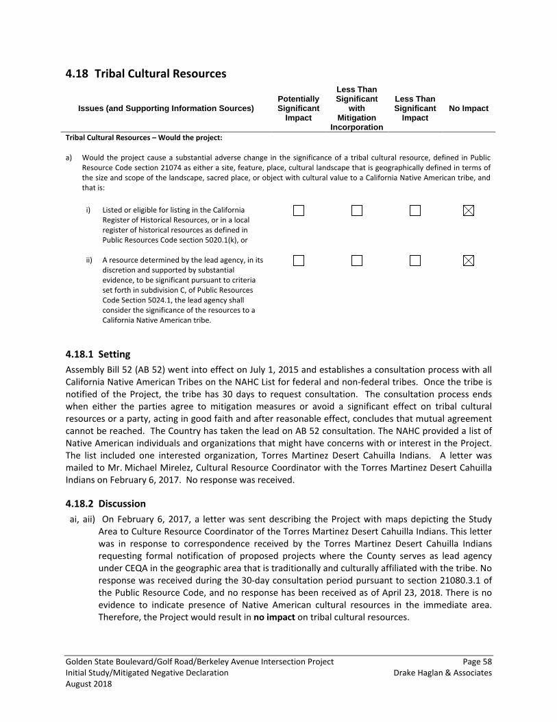
Golden State Boulevard/Golf Road/Berkeley Avenue Intersection Project Page 58 Initial Study/Mitigated Negative Declaration Drake Haglan & Associates August 2018
Tribal Cultural Resources 4.18
Issues (and Supporting Information Sources) Potentially Significant
Impact
Less Than Significant
with Mitigation
Incorporation
Less Than Significant
Impact No Impact
Tribal Cultural Resources – Would the project: a) Would the project cause a substantial adverse change in the significance of a tribal cultural resource, defined in Public
Resource Code section 21074 as either a site, feature, place, cultural landscape that is geographically defined in terms of the size and scope of the landscape, sacred place, or object with cultural value to a California Native American tribe, and that is:
i) Listed or eligible for listing in the California
Register of Historical Resources, or in a local register of historical resources as defined in Public Resources Code section 5020.1(k), or
ii) A resource determined by the lead agency, in its discretion and supported by substantial evidence, to be significant pursuant to criteria set forth in subdivision C, of Public Resources Code Section 5024.1, the lead agency shall consider the significance of the resources to a California Native American tribe.
4.18.1 Setting Assembly Bill 52 (AB 52) went into effect on July 1, 2015 and establishes a consultation process with all California Native American Tribes on the NAHC List for federal and non-federal tribes. Once the tribe is notified of the Project, the tribe has 30 days to request consultation. The consultation process ends when either the parties agree to mitigation measures or avoid a significant effect on tribal cultural resources or a party, acting in good faith and after reasonable effect, concludes that mutual agreement cannot be reached. The Country has taken the lead on AB 52 consultation. The NAHC provided a list of Native American individuals and organizations that might have concerns with or interest in the Project. The list included one interested organization, Torres Martinez Desert Cahuilla Indians. A letter was mailed to Mr. Michael Mirelez, Cultural Resource Coordinator with the Torres Martinez Desert Cahuilla Indians on February 6, 2017. No response was received.
4.18.2 Discussion ai, aii) On February 6, 2017, a letter was sent describing the Project with maps depicting the Study
Area to Culture Resource Coordinator of the Torres Martinez Desert Cahuilla Indians. This letter was in response to correspondence received by the Torres Martinez Desert Cahuilla Indians requesting formal notification of proposed projects where the County serves as lead agency under CEQA in the geographic area that is traditionally and culturally affiliated with the tribe. No response was received during the 30-day consultation period pursuant to section 21080.3.1 of the Public Resource Code, and no response has been received as of April 23, 2018. There is no evidence to indicate presence of Native American cultural resources in the immediate area. Therefore, the Project would result in no impact on tribal cultural resources.
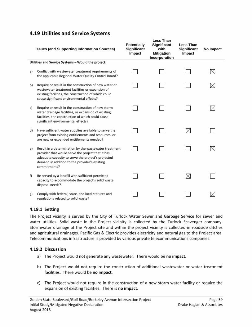
Golden State Boulevard/Golf Road/Berkeley Avenue Intersection Project Page 59 Initial Study/Mitigated Negative Declaration Drake Haglan & Associates August 2018
Utilities and Service Systems 4.19
Issues (and Supporting Information Sources) Potentially Significant
Impact
Less Than Significant
with Mitigation
Incorporation
Less Than Significant
Impact No Impact
Utilities and Service Systems – Would the project: a) Conflict with wastewater treatment requirements of
the applicable Regional Water Quality Control Board?
b) Require or result in the construction of new water or wastewater treatment facilities or expansion of existing facilities, the construction of which could cause significant environmental effects?
c) Require or result in the construction of new storm water drainage facilities, or expansion of existing facilities, the construction of which could cause significant environmental effects?
d) Have sufficient water supplies available to serve the project from existing entitlements and resources, or are new or expanded entitlements needed?
e) Result in a determination by the wastewater treatment provider that would serve the project that it has adequate capacity to serve the project’s projected demand in addition to the provider’s existing commitments?
f) Be served by a landfill with sufficient permitted capacity to accommodate the project’s solid waste disposal needs?
g) Comply with federal, state, and local statutes and regulations related to solid waste?
4.19.1 Setting The Project vicinity is served by the City of Turlock Water Sewer and Garbage Service for sewer and water utilities. Solid waste in the Project vicinity is collected by the Turlock Scavenger company. Stormwater drainage at the Project site and within the project vicinity is collected in roadside ditches and agricultural drainages. Pacific Gas & Electric provides electricity and natural gas to the Project area. Telecommunications infrastructure is provided by various private telecommunications companies.
4.19.2 Discussion a) The Project would not generate any wastewater. There would be no impact.
b) The Project would not require the construction of additional wastewater or water treatment facilities. There would be no impact.
c) The Project would not require in the construction of a new storm water facility or require the expansion of existing facilities. There is no impact.
Golden State Boulevard/Golf Road/Berkeley Avenue Intersection Project Page 60 Initial Study/Mitigated Negative Declaration Drake Haglan & Associates August 2018
d) The Project is an intersection improvement project and would not require a water supply for its operation. The Project would require some non-potable water during construction for dust control. This would be a less-than-significant impact.
e) The Project does not require wastewater treatment services. There would be no impact to wastewater treatment facilities.
f) The Project would generate waste from temporary construction activities and demolition of sections of the intersection. Solid waste associated with construction activities would be handled by Fink Road Sanitary Landfill located on 4000 Fink Road in Crows Landing. This landfill has the capacity to accept waste generated by the Project. The Project would not result in long-term demands for solid waste disposal services. This would be a less-than-significant impact.
g) The Project would comply with all federal, state, and local statues and regulations related to solid waste. There would be no impact.
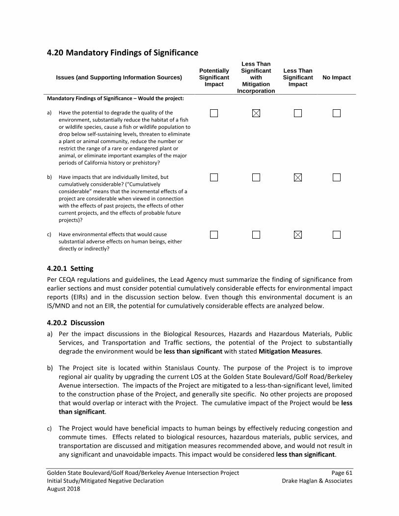
Golden State Boulevard/Golf Road/Berkeley Avenue Intersection Project Page 61 Initial Study/Mitigated Negative Declaration Drake Haglan & Associates August 2018
Mandatory Findings of Significance 4.20
Issues (and Supporting Information Sources) Potentially Significant
Impact
Less Than Significant
with Mitigation
Incorporation
Less Than Significant
Impact No Impact
Mandatory Findings of Significance – Would the project: a) Have the potential to degrade the quality of the
environment, substantially reduce the habitat of a fish or wildlife species, cause a fish or wildlife population to drop below self-sustaining levels, threaten to eliminate a plant or animal community, reduce the number or restrict the range of a rare or endangered plant or animal, or eliminate important examples of the major periods of California history or prehistory?
b) Have impacts that are individually limited, but cumulatively considerable? (“Cumulatively considerable” means that the incremental effects of a project are considerable when viewed in connection with the effects of past projects, the effects of other current projects, and the effects of probable future projects)?
c) Have environmental effects that would cause substantial adverse effects on human beings, either directly or indirectly?
4.20.1 Setting Per CEQA regulations and guidelines, the Lead Agency must summarize the finding of significance from earlier sections and must consider potential cumulatively considerable effects for environmental impact reports (EIRs) and in the discussion section below. Even though this environmental document is an IS/MND and not an EIR, the potential for cumulatively considerable effects are analyzed below.
4.20.2 Discussion a) Per the impact discussions in the Biological Resources, Hazards and Hazardous Materials, Public
Services, and Transportation and Traffic sections, the potential of the Project to substantially degrade the environment would be less than significant with stated Mitigation Measures.
b) The Project site is located within Stanislaus County. The purpose of the Project is to improve regional air quality by upgrading the current LOS at the Golden State Boulevard/Golf Road/Berkeley Avenue intersection. The impacts of the Project are mitigated to a less-than-significant level, limited to the construction phase of the Project, and generally site specific. No other projects are proposed that would overlap or interact with the Project. The cumulative impact of the Project would be less than significant.
c) The Project would have beneficial impacts to human beings by effectively reducing congestion and commute times. Effects related to biological resources, hazardous materials, public services, and transportation are discussed and mitigation measures recommended above, and would not result in any significant and unavoidable impacts. This impact would be considered less than significant.
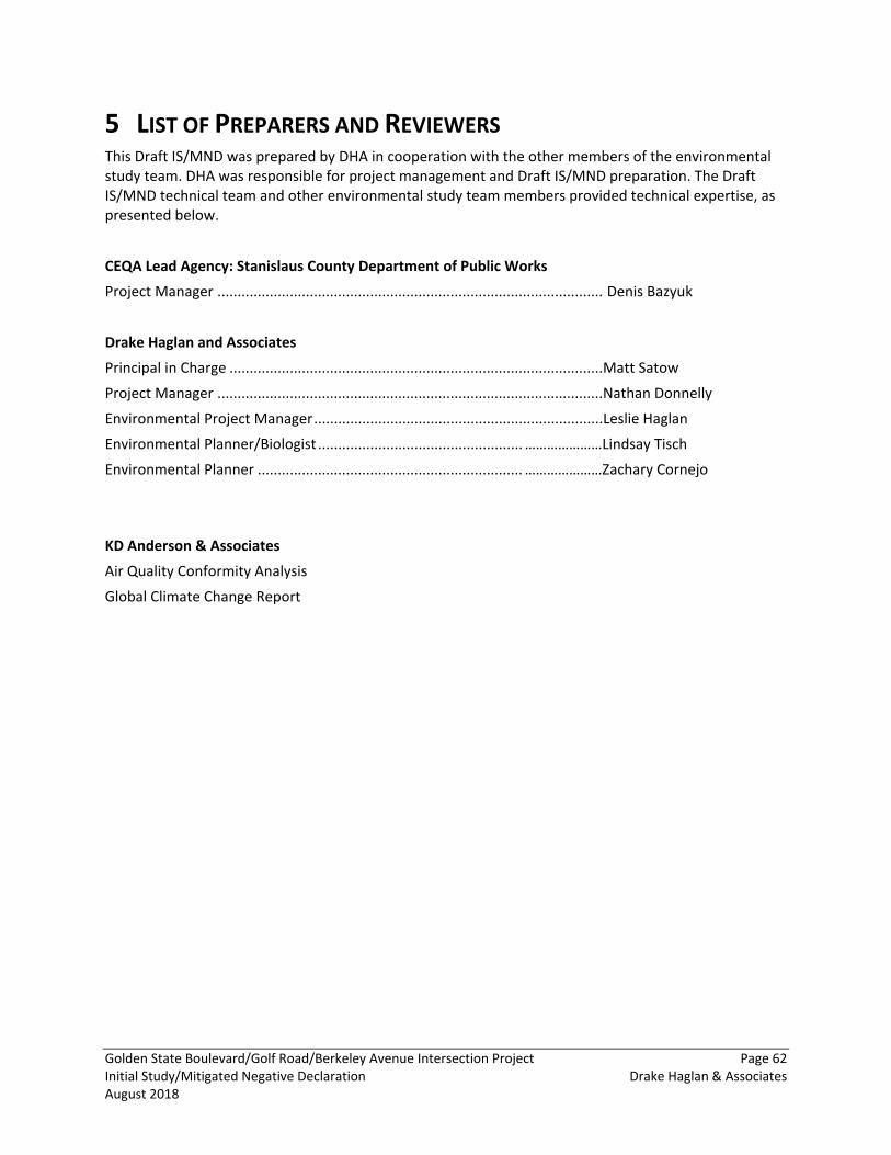
Golden State Boulevard/Golf Road/Berkeley Avenue Intersection Project Page 62 Initial Study/Mitigated Negative Declaration Drake Haglan & Associates August 2018
5 LIST OF PREPARERS AND REVIEWERS This Draft IS/MND was prepared by DHA in cooperation with the other members of the environmental study team. DHA was responsible for project management and Draft IS/MND preparation. The Draft IS/MND technical team and other environmental study team members provided technical expertise, as presented below.
CEQA Lead Agency: Stanislaus County Department of Public Works
Project Manager ................................................................................................ Denis Bazyuk
Drake Haglan and Associates
Principal in Charge .............................................................................................Matt Satow
Project Manager ................................................................................................Nathan Donnelly
Environmental Project Manager ........................................................................Leslie Haglan
Environmental Planner/Biologist ................................................... …………………Lindsay Tisch
Environmental Planner .................................................................. …………………Zachary Cornejo
KD Anderson & Associates
Air Quality Conformity Analysis
Global Climate Change Report
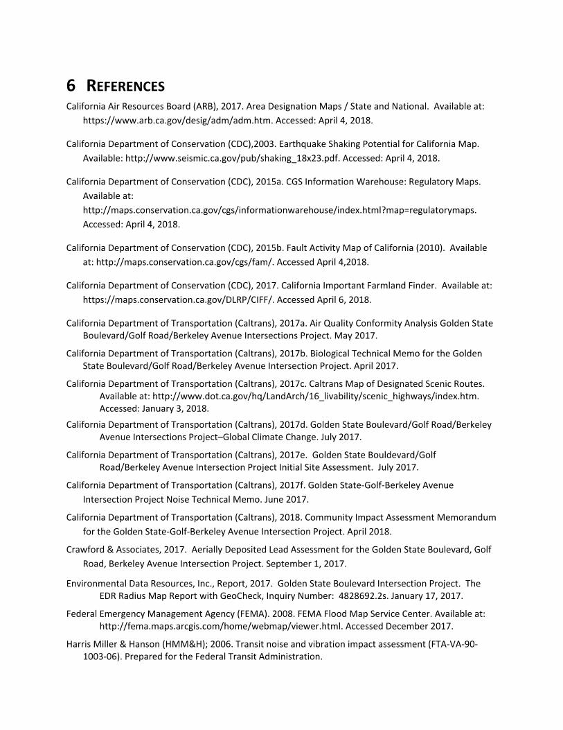
6 REFERENCES California Air Resources Board (ARB), 2017. Area Designation Maps / State and National. Available at:
https://www.arb.ca.gov/desig/adm/adm.htm. Accessed: April 4, 2018.
California Department of Conservation (CDC),2003. Earthquake Shaking Potential for California Map. Available: http://www.seismic.ca.gov/pub/shaking_18x23.pdf. Accessed: April 4, 2018.
California Department of Conservation (CDC), 2015a. CGS Information Warehouse: Regulatory Maps. Available at: http://maps.conservation.ca.gov/cgs/informationwarehouse/index.html?map=regulatorymaps. Accessed: April 4, 2018.
California Department of Conservation (CDC), 2015b. Fault Activity Map of California (2010). Available at: http://maps.conservation.ca.gov/cgs/fam/. Accessed April 4,2018.
California Department of Conservation (CDC), 2017. California Important Farmland Finder. Available at: https://maps.conservation.ca.gov/DLRP/CIFF/. Accessed April 6, 2018.
California Department of Transportation (Caltrans), 2017a. Air Quality Conformity Analysis Golden State Boulevard/Golf Road/Berkeley Avenue Intersections Project. May 2017.
California Department of Transportation (Caltrans), 2017b. Biological Technical Memo for the Golden State Boulevard/Golf Road/Berkeley Avenue Intersection Project. April 2017.
California Department of Transportation (Caltrans), 2017c. Caltrans Map of Designated Scenic Routes. Available at: http://www.dot.ca.gov/hq/LandArch/16_livability/scenic_highways/index.htm. Accessed: January 3, 2018.
California Department of Transportation (Caltrans), 2017d. Golden State Boulevard/Golf Road/Berkeley Avenue Intersections Project–Global Climate Change. July 2017.
California Department of Transportation (Caltrans), 2017e. Golden State Bouldevard/Golf Road/Berkeley Avenue Intersection Project Initial Site Assessment. July 2017.
California Department of Transportation (Caltrans), 2017f. Golden State-Golf-Berkeley Avenue Intersection Project Noise Technical Memo. June 2017.
California Department of Transportation (Caltrans), 2018. Community Impact Assessment Memorandum for the Golden State-Golf-Berkeley Avenue Intersection Project. April 2018.
Crawford & Associates, 2017. Aerially Deposited Lead Assessment for the Golden State Boulevard, Golf Road, Berkeley Avenue Intersection Project. September 1, 2017.
Environmental Data Resources, Inc., Report, 2017. Golden State Boulevard Intersection Project. The EDR Radius Map Report with GeoCheck, Inquiry Number: 4828692.2s. January 17, 2017.
Federal Emergency Management Agency (FEMA). 2008. FEMA Flood Map Service Center. Available at: http://fema.maps.arcgis.com/home/webmap/viewer.html. Accessed December 2017.
Harris Miller & Hanson (HMM&H); 2006. Transit noise and vibration impact assessment (FTA-VA-90-1003-06). Prepared for the Federal Transit Administration.
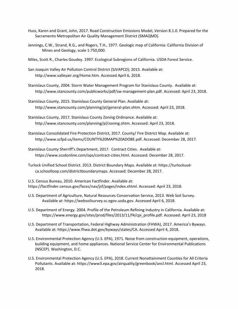
Huss, Karen and Grant, John, 2017. Road Construction Emissions Model, Version 8.1.0. Prepared for the Sacramento Metropolitan Air Quality Management District (SMAQMD).
Jennings, C.W., Strand, R.G., and Rogers, T.H., 1977. Geologic map of California: California Division of Mines and Geology, scale 1:750,000.
Miles, Scott R., Charles Goudey. 1997. Ecological Subregions of California. USDA Forest Service.
San Joaquin Valley Air Pollution Control District (SJVAPCD); 2015. Available at: http://www.valleyair.org/Home.htm. Accessed April 6, 2018.
Stanislaus County, 2004. Storm Water Management Program for Stanislaus County. Available at: http://www.stancounty.com/publicworks/pdf/sw-management-plan.pdf. Accessed: April 23, 2018.
Stanislaus County, 2015. Stanislaus County General Plan. Available at: http://www.stancounty.com/planning/pl/general-plan.shtm. Accessed: April 23, 2018.
Stanislaus County, 2017. Stanislaus County Zoning Ordinance. Available at: http://www.stancounty.com/planning/pl/zoning.shtm. Accessed: April 23, 2018.
Stanislaus Consolidated Fire Protection District, 2017. County/ Fire District Map. Available at: http://www.scfpd.us/items/COUNTY%20MAP%20ADOBE.pdf. Accessed: December 28, 2017.
Stanislaus County Sherriff’s Department, 2017. Contract Cities. Available at: https://www.scsdonline.com/ops/contract-cities.html. Accessed: December 28, 2017.
Turlock Unified School District. 2013. District Boundary Maps. Available at: https://turlockusd-ca.schoolloop.com/districtboundarymaps. Accessed: December 28, 2017.
U.S. Census Bureau, 2010. American Factfinder. Available at: https://factfinder.census.gov/faces/nav/jsf/pages/index.xhtml. Accessed: April 23, 2018.
U.S. Department of Agriculture, Natural Resources Conservation Service, 2013. Web Soil Survey. Available at: https://websoilsurvey.sc.egov.usda.gov. Accessed April 6, 2018.
U.S. Department of Energy. 2004. Profile of the Petroleum Refining Industry in California. Available at: https://www.energy.gov/sites/prod/files/2013/11/f4/cpi_profile.pdf. Accessed: April 23, 2018
U.S. Department of Transportation, Federal Highway Administration (FHWA), 2017. America’s Byways. Available at: https://www.fhwa.dot.gov/byways/states/CA. Accessed April 4, 2018.
U.S. Environmental Protection Agency (U.S. EPA), 1971. Noise from construction equipment, operations, building equipment, and home appliances. National Service Center for Environmental Publications (NSCEP). Washington, D.C.
U.S. Environmental Protection Agency (U.S. EPA), 2018. Current Nonattainment Counties for All Criteria Pollutants. Available at: https://www3.epa.gov/airquality/greenbook/ancl.html. Accessed April 23, 2018.

U.S. Geological Survey and California Geological Survey, 2006. Quaternary fault and fold database for the United States. http://earthquakes.usgs.gov/regional/qfaults/. Accessed April 6, 2018.