Embed Size (px)
Citation preview

GOVERNMENT OF JHARKHAND
DEPARTMENT OF MINES & GEOLOGY
Ranchi, 2011-12
THE LAND OF MINES AND MINERAL

Saranda Forest

|3|Ranchi, 2011-12
DEPARTMENT OF MINES & GEOLOGY
GOVERNMENT OF JHARKHAND
THE LAND OF MINES AND MINERAL

C o n t e n t sIntroduction 1
Infrastructure 1
Physiography 2
River Basins of Jharkhand 3
Geological History of Jharkhand 5
Geology and Mineral Resources 6
Ü Geology 6
Ü Singhbhum Shear Zone 6
Ü Mineral Resources 6
Status of Important Mineral Resources of Jharkhand. 7
Important Mineral Deposits of Jharkhand 8
Ü Energy Group of Minerals 8
Ü Ferrous Group of Minerals 8
Ü Non-Ferrous Group of Minerals 9
Ü Industrial Group of Minerals 10
Ü Refractory Group of Minerals 14
Ü Nobel Metal Group 15
Ü Strategic Minerals 15
Ü Decorative, Precious & Semi Precious Stone 16
Mineral Revenue Collection 16
Mineral Production 17
Mineral-Based Industries in Jharkhand 18

|1|
IntroductIonJharkhand state is a land blessed with the natural gift of immense mineral potential. The state holds a strong position on the mineral map of the country and is the store house of more than 30 types of minerals possessing potential deposits of energy (Coal, CBM), ferrous (Hematite, Magnetite, Manganese, Chromite), non-ferrous (Bauxite, Copper), industrial (Limestone, Graphite, Pyroxenite, Bentonite, Barite, Asbestos, China Clay, Dolomite, Feldspar, Quartz, Quartzite, Silica Sand), fertilizer (Phosphorite, Apatite), refractory (Fire Clay, Kyanite, Mica, Magnesite), atomic (Uranium), precious and semi-precious groups of minerals.
The state is endowed with a large and rich deposit of Coal, Iron ore, Bauxite, Limestone, Copper, Mica, Graphite and Uranium. Besides these it also possesses various other minerals in medium and small quantities viz. andalusite, apatite, Asbestos, Bentonite, Baryte, Chinaclay, Chromite, Dolomite, Felspar, Fireclay, Kyanite, Magnetite, Manganese, Noble metals (Gold & Silver), Pyrite, Quartz, Quartzite, Steatite and several varities of Gemstontes.
The state has rich and oldest heritage of mining and industrial growth and is well exemplified by establishment of first iron & steel manufacturing industry in 1904 by Tata. Presently the state is producing about 160 million tonnes of various minerals annually worth Rs. 15,000 crore.
With such vast mineral resources spread over an area of 79,714 sq. km and a strong human strength of 2.69 crores, the state has tremendous potential for establishment of mineral based industries.
InFrAStructurERoadRoads are the major means of transportation in the state. The total length of National Highway, State Highway and others metalled roads in Jharkhand is 8,070 km. while that of the rural un-metalled roads is 8,986 km.
RailwaysThe state has very good network of railways. The total rail length in the state is 1053 km. Most of the mineral bearing areas are well connected with the railways. Several railway connectivity projects are underway in the state which is expected to be implemented in the next 4 - 5 years.
AirwaysThe capital of Jharkhand is Ranchi which is well connected with air from Delhi, Patna, Kolkata, Bhubneshwer, Raipur, Jaipur, Chandigarh and Mumbai. Some other places like, Jamshedpur, Dhanbad, Deoghar, Chakulia and Bokaro have air stripes. The airport at Ranchi is being upgraded as an international airport.

|2|
Power ProfileJharkhand is rich in both renewable and non-renewable resources of energy with abundance of water falls, rivers, nuclear minerals and huge coal reserve. The existing power generation capacity of the state is 2,590 MW. There is immense scope for further development of mini, micro hydro power stations and non-conventional energy, apart from mega thermal power stations. The State Government has encouraged captive power generation in the state and it is expected that the total power generation capacity of the state will go up to 4,500 MW in the coming years.
PHYSIoGrAPHYThe physiography of Jharkhand is largely defined by the Chhotanagpur Plateau (CNP) region and other distinct geomorphic domains. The Chhotanagpur Plateau (CNP) region extending from the western part of state to the border of West Bengal in the east is characterized by distinct steps i.e. level of planation. This has been further divided into a number of 2nd and 3rd order division based on variation in relief, drainage and geology. Based on broad geomorphic parameters, Jharkhand may be divided into the following geomorphic domains:-
Ranchi PlateauThis is the largest part of the Chhotanagpur Plateau having an average elevation of about 700 meters above msl. There are many waterfalls at the edges of Ranchi Plateau where rivers form waterfalls when they descend through the escarpments of the plateau down to the area of significantly lower height. That is the reason the plateau is highly dissected at the edges. Hundru Falls (75m) on Subarnarekha River, Dassam Falls (39m) on Kanchi River and Sadni Falls (60 m) on Sankh River are some of the examples of scarp falls.
Hazaribagh PlateauThis lies to the north of Ranchi Plateau and is separated by E-W running Damuda valley in which deposition of Gondwana sediments took place. The Hazaribagh Plateau measures about 64 km (east-west) and 24 km (north-south) with an average elevation of 610 m. The north-eastern and southern faces of this plateau are mostly abrupt but to the west it narrows and descends to the south and connects with the Ranchi Plateau through Tori Pargana. As the plateau is highly dissected at the edges, seen from the north, the edge of this plateau has the appearance of a range of hills.
Koderma PlateauThe Koderma Plateau is also referred to as the Hazaribagh Lower Plateau. The northern face of this plateau, elevated 800 ft above the plains of Bihar has the appearance of a range of hills but in reality it is the edge of a plateau. The slope of this plateau to the east is uniform and gentle. The western boundary of the plateau is formed by the deep bed of the Lilajan River. The southern boundary consists of the face of the higher plateau comprising Parasnath Hills.
The Pat RegionThe Netarhat Planation Surface locally known as PATS has also been referred to as Western Ranchi Plateau. This is the highest plateau region of the Chhotanagpur Plateau with an average height of 1000 meters the highest point being 1164 meters. Pat Region is characterized by level surface. The denudation and secondary enrichment of Granite Gneiss of this region has given rise to some of the best Bauxite deposits.
Singhbhum
1250’ 2 5 0 ’
Dam
odar
Valle
y
Haz
arib
agh
Plat
eau
Dis
sect
edbe
lt
Dis
sect
edbe
lt
Koda
rma
D i s s e c t e d r e g i o n R a n c h i p l a t e a u 2 0 0 0 ’
Section across Jharkhand (from north to south) showing Physiography of cnP(Arrows indicate direction of movement)

|3|
Simdega-Singhmbhum Uplands The Ranchi Plateau gradually slopes down towards south east into Singhbhum region. This region is characterized by highly dissected high (600-900 m) rugged hills, steep hill sides, cliffs and narrow valleys; the reason of this high dissection being the type of rock more susceptible to erosion and structurally highly disturbed area. The prominent tectonic feature, the Singhbhum Shear Zone (SSZ) runs south of Dalma Range arcuately for a length of 150 km in this region. To the north of Tatanagar, the Dalma hills (500-600m) form a prominent east-west trending hill range.
Manbhum Area The lowest step of the Chotanagpur Plateau, the Manbhum area covers Dhanbad and part of Bokaro district. This area has a general elevation of 300 meter and it consists of undulating land with scattered hills.
Palamu Plateau It lies at a lower height then the surrounding areas of Chotnagpur Plateau. This upland intrudes the Ranchi plateau on the east and merges with the Pat Region in the south. On the west are the Surguja highlands of Chhattishgarh and Sonbhadra district of Uttar Pradesh. On the north-western corner, the Son River forms the state boundary.
Rajmahal Plateau The Rajmahal hills composed primarily of Mesozoic volcanic basaltic traps along with Gondwana sediments in the form of Intra Trappean Beds form a plateau (150-200m) above msl in Shaebganj and Pakur districts of the eastern part of the state of Jharkhand. The Rajmahal plateau trends N-S with a slope towards east possibly as a result of uplift in the west. The subsidence of the eastern region had led to the deposition of Recent Ganga sediments on this part.
Damodar Valley The Damodar Valley is a trough between the Ranchi and Hazaribagh plateaus resulting from enormous fracture. This basin had been the place of deposition of several hundred meters of Gondwana sediments ranging in age from late Carboniferous to early Cretaceous, later constituting the great belt of Damodar Valley Gondwana Coalfields.
rIvEr BASInS oF JHArkHAndDamodar Basin : Damodar, Barakar, Bokaro, Konar, Jamunia, Khadia and Bhera.
Subarnarekha Basin : Subarnarekha, Kharkai, Raru, Kanchi, Damra, Karru, Chinguru, Garra
Brahmani Basin (Orissa & Jharkhand)
: Deo, Koina, North karo, Sankh, South karo, South koel
Son Basin : Amanat, Auranga, Burha, Kanhar, North koel, Son
others :
N Flowing : Kiul, Lilajan, Mohana, Punpun
E Flowing : Ajay, Bakreshwar, Bansloi, Brahmani, Dwarka, Mayurakshi
SE Flowing : Baitarani, Telen
Damodar River BasinThe Damodar River originates near Chandwa village in Palamau district, flows eastward for about 592 km through the states of Jharkhand and West Bengal to finally join the Hughli south of Kolkata. It forms a major river basin in Jharkhand comprising a number of tributaries. Important amongst them are:
Ü Barakar river: Main tributary of Damodar River, originates near Padma in Hazaribagh district, flows easterly across the northern part of the Chota Nagpur Plateau before joining the Damodar in West Bengal.

|4|
Ü Bokaro river: It rises on the Hazaribagh plateau, south of Hazaribagh, flows through Hazaribagh and Bokaro districts and flows into the Konar River before that joins the Damodar river.
Ü konar river: The Konar originates near Sultana village on the Hazaribagh-Chatra Road, flows through Hazaribagh and Bokaro districts and finally joins the Damodar in Bokaro district.
Subarnarekha River BasinSubarnarekha river after originating near Piska/ Nagri in Ranchi traverses through Ranchi, Seraikela-Kharsawan and East Singhbhum districts. It eventually joins the Bay of Bengal near Talsari in Bengal. It’s important tributary is :
Ü kharkai river: Originates in Mayurbhanj district of Orissa, flows past Rairangpur and heads north of about Saraikela and then turns east to meet Subernrekha in NW of Jamshedpur
Brahmani River Basin The Brahmani is formed by the confluence of the rivers South Koel and Sankh at Ved Vyas near Raurkela. Major portion of this river basin lies within the state of Orissa while a small patch lies in the state of Jharkhand. It forms a large delta, the site of the Bhitarkanika wildlife sanctuary before entering into the Bay of Bengal at Dhamra. It’s main tributaries are:
Ü north karo river: It originates on the Ranchi Plateau, drains the Gumla, Ranchi and West Singhbhum districts and finally joins the South Koel near Serengda.
Ü South karo river: The river flows through industrial and iron ore mining areas and Saranda forest before joining the South Koel River in Goilkera block of West Singhbhum district.
Ü deo river: It rises on the western side of the Gamharia plateau flows through West Singhbhum district and joins the South Karo river
Ü Sankh river: Originates near Jharkhand - Chhatisgarh border in Lupungpat village in Guma Distt, flows for a distance of 240 km before it meets the Koel river in Orissa.
Ü South koel river: This river rises near Lohardaga on the other side of the watershed that also gives rise to damodar River. It runs across Jharkhand and Orissa. It enters Orissa and joins with Sankh river at Ved Vyas near Rourkela from where it is named as Brahmani.
Son River BasinSone river originates near Amarkantak in Madhya Pradesh, flows E-NE through Jharkhand and finally joins Ganges just above Patna. It’s main tributaries are:
Ü Amanat river: It originates on the Hazaribagh plateau flows through Chatra and Palamu districts and then joins the North Koel River five miles north of Daltonganj.
Ü north koel river: It rises on the Ranchi plateau, enters Palamau division, flows due west for about twenty miles, turns north and falls into the Son a few miles north-west of Haidarnagar.
Ü Auranga river : It originates near Soheda in a pass, flows through Latehar and Palamu districts, flows in a north-westerly direction and eventually meets the Koel near Kechki 10 miles south of Daltonganj.
East Flowing Rivers: Ü Bakreshwar river: It is a tributary of the Mayurakshi River. It originates in Santhal Parganas division of Jharkhand,
flows in to the Mayurakshi River in Murshidabad district.
Ü dwarka river : It originates in Santhal Parganas, flows through Birbhum district and then flows through Murshidabad district where it joins the Bhagirathi.
Ü Ajay river : Originates on a small hill in Munger district of Bihar, forms the border between Bardhaman District of West Bengal & Jharkhand. It’s main tributaries are Pathro and Jayanti

|5|
Ü Mayurakshi : Rises from Trikut Pahar in Deoghar district, flows across Godda, Deoghar, Dumka and Sahebganj districts. There is Massanjore Dam across this river at 30 km NE of Dumka
Ü Bansloi: River:Originates in Bans Hills in Sahebganj distt, flows through Pakur distt and eventually flows into Bhagirathi.
North Flowing Rivers: Ü kiul river : The Kiul originates from the Tisri Hill Range in Giridih district. It first flows through Jamui and Lakhisarai
districts. It falls into the Ganges near Surajgarha.
Ü Lilajan river : The Lilajan originates north of Simaria in Chatra district on the Hazaribagh plateau, south of Gaya it unites with the Mohana River to form Falgu River.
Ü Punpun river: It originates in Palamu district at an elevation of 300 metres, flows in a north-east direction through Chatra, Aurangabad, Gaya and Patna districts and joins the Ganges at Fatuha.
South East Flowing Rivers: Ü Baitarani river: The Baitarani originates from the Guptaganga hills in Gonasika of Keonjhar district in
Orissa. The beginning portion of Baitarani acts as the boundary between Orissa and Jharkhand. A major portion of the river basin lies within the state of Orissa while a small patch of the upper reach lies in Jharkhand state.
GEoLoGIcAL HIStorY oF JHArkHAnd
The Older Metamorphics of Singhbhum region is believed to be the oldest rock exposed in the state constituting the basement of the Iron Ore Series. The Older Metamorphic Group Orogenic Cycle continued to operate till 3000 Ma whereas the Iron Ore Orogeny Cycle continued up to 2000 Ma in the Southern Singhbhum. The Singhbhum Orogeny continued up to 905-934 Ma in the Northern Singhbhum. The low and high grade facies rocks in the Northern Singhbhum are the strtigraphic equivalent and their juxtaposition had been brought about by the Singhbhum Thrust. The end of Iron Ore Orogeny was marked by intrusion of Singhbhum Granite, polyphase deformation and metamorphism in the Northern Singhbhum. This phase of polyphase deformation, metamorphism and igneous intrusion culminated in upliftment of the Precambrian rocks of the state. This resulted in to development of a stable and cratonized Precambrian terrain.
This was followed by a prolonged period of denudation and sedimentation. A number of sedimentary groups have formed during this period. The Kolhan Group and the Vindhyan Group are such examples in South Singhbhum and in Garhwa districts respectively. After this there was a big pause in the geological history of the state. At the end of the Palaeozoic era, i.e. towards the Upper Carboniferous a new series of changes took place manifested by gravity block faulting of the Chhotanagpur Granite Gneiss terrain. This resulted in development of a number of basins in which deposition of sediments in glacial condition (Talchir), fluvial and lacustrine conditions with intercalated plant remains (Damudas), flood plains and shallow lakes (Panchets) and arid condition (Mahadevas) took place. The post-Panchet and pre-Mahadeva period witnessed transverse faulting in the Gondwana basin. After this the crust of the earth is appeared to have experienced regional tension resulting in outpouring of vast quantity of basaltic lava and volcanic material forming Rajmahal Traps. After the Rajmahal period, the Jharkhand region did not experience any major geological activity.
A number of eminent Geoscientists have contributed significantly in exploring the geology of Jharkhand. H. W. Voysey, Lieut. Tickells, Col. J. C. Haudhton, Emil Stoeher and V. Ball were amongst the earliest workers to have worked in the region between 1844-1868. The work of Sri P. N. Bose led to the discovery of Gorumahisani iron ore deposit which eventually gave birth to the first iron ore company TISCO in 1904. H. C Jones (1918-1932), J. A. Dunn (1940) and Dunn and Day (1942) were the pioneer workers who had done the regional geological mapping of Singhbhum and surrounding region. Detail geological work in the region was done by Holmes, Sarkar and Saha.
|6|
GEoLoGY And MInErAL rESourcESGeologyJharkhand state a part of the Indian Peninsular Shield is a stable cratonic block of the earth’s crust. Jharkhand is known for its diversified geological set up. The whole of Singhbhum region is considered as a natural geological museum. Geologically, Jharkhand consists of different types of rock formations ranging from Pre-Cambrian to Cenozoic era.
The most predominant hard rocks in the state comprise of the Archaean metamorphics with associated intrusives and sedimentaries belonging to Vindhyan and Gondwana Super Group with associated igneous rocks. The Raj Mahal hills, lying in the north-eastern extremity of the Chotanagpur Plateau consists of Jurassic volcanic lava flows.
The Archaean metamorphics occur in East and West Singhbhum, Ranchi, Gumla, Lohardaga, Palamu, Giridih, Hazaribagh, Chatra, Ramgarh, Dhanbad, Godda, Deoghar and Dumka districts. They are represented by various types of Schists, Gneisses, Granulities, Quartzites, Meta basics and other basic intrusives and Granites. The Archaean formations of West Singhbhum district possesses the iron bearing Iron Ore Group.
The Vindhyans comprising chiefly of Khenjua-shales, Procelanite, Limestone and Sandstones occupy a small area in the north-western part of Garhwa district. The Gondwanas are represented by alteration of agrillaceous and arenaceous sediment & intervened with numerous coal seams. They are located in Palamu, Ranchi, Hazaribagh, Bokaro, Chatra, Dumka, Giridih, Dhanbad and Godda districts.
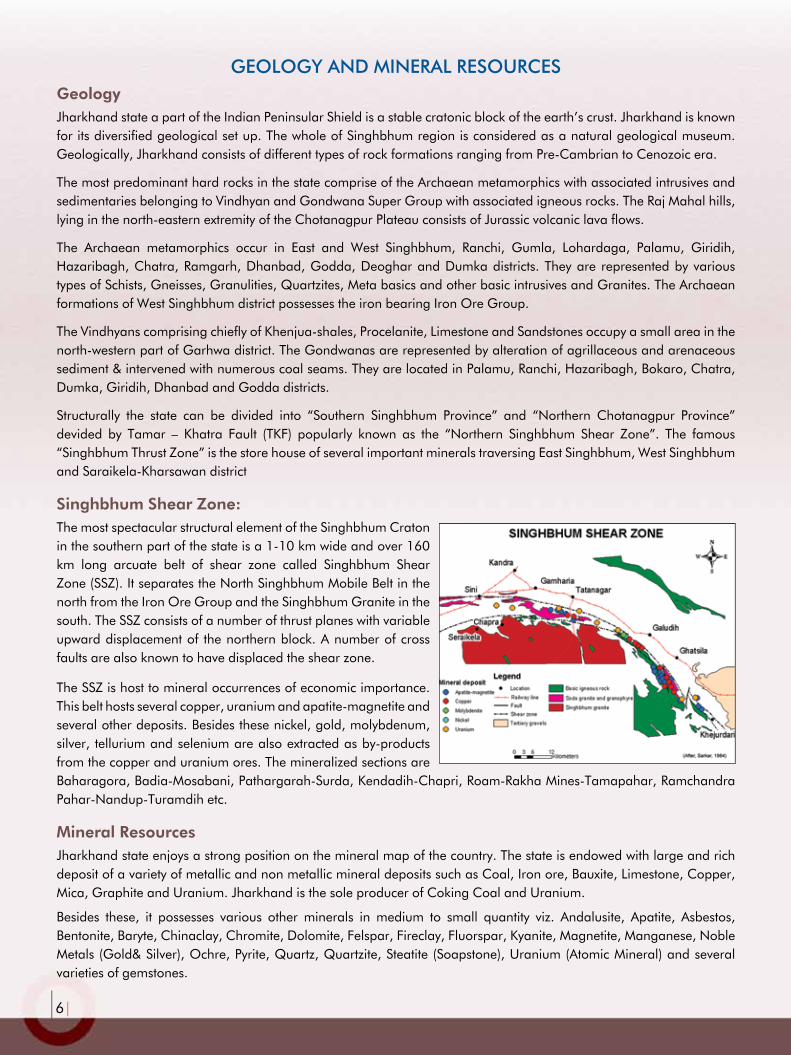
Structurally the state can be divided into “Southern Singhbhum Province” and “Northern Chotanagpur Province” devided by Tamar – Khatra Fault (TKF) popularly known as the “Northern Singhbhum Shear Zone”. The famous “Singhbhum Thrust Zone” is the store house of several important minerals traversing East Singhbhum, West Singhbhum and Saraikela-Kharsawan district
Singhbhum Shear Zone:The most spectacular structural element of the Singhbhum Craton in the southern part of the state is a 1-10 km wide and over 160 km long arcuate belt of shear zone called Singhbhum Shear Zone (SSZ). It separates the North Singhbhum Mobile Belt in the north from the Iron Ore Group and the Singhbhum Granite in the south. The SSZ consists of a number of thrust planes with variable upward displacement of the northern block. A number of cross faults are also known to have displaced the shear zone.
The SSZ is host to mineral occurrences of economic importance. This belt hosts several copper, uranium and apatite-magnetite and several other deposits. Besides these nickel, gold, molybdenum, silver, tellurium and selenium are also extracted as by-products from the copper and uranium ores. The mineralized sections are Baharagora, Badia-Mosabani, Pathargarah-Surda, Kendadih-Chapri, Roam-Rakha Mines-Tamapahar, Ramchandra Pahar-Nandup-Turamdih etc.
Mineral ResourcesJharkhand state enjoys a strong position on the mineral map of the country. The state is endowed with large and rich deposit of a variety of metallic and non metallic mineral deposits such as Coal, Iron ore, Bauxite, Limestone, Copper, Mica, Graphite and Uranium. Jharkhand is the sole producer of Coking Coal and Uranium.
Besides these, it possesses various other minerals in medium to small quantity viz. Andalusite, Apatite, Asbestos, Bentonite, Baryte, Chinaclay, Chromite, Dolomite, Felspar, Fireclay, Fluorspar, Kyanite, Magnetite, Manganese, Noble Metals (Gold& Silver), Ochre, Pyrite, Quartz, Quartzite, Steatite (Soapstone), Uranium (Atomic Mineral) and several varieties of gemstones.

|7|
Mineral availability at A Glance
Available Mineral Resources in PLENTYChina Clay, Fireclay, Magnetite, Graphite, Kyanite, Copper, Bauxite, Feldspar, Mica & Decorative Stones.
Available Mineral Resources SUFFICIENT Coal, Iron Ore, Limestone, Quartz Quartzite, Dolomite, Pyroxenite
Available Mineral Resources INSUFFICIENT Andalusite, Manganese, Chromite, Beryl, Talc, Gold, Bentonite
StAtuS oF IMPortAnt MInErAL rESourcES oF JHArkHAnd.SL. n0.
MInErALreserve/resource (In Million tonnes)
AvAILABLE GrAdE
1 COAL (C) * 76711.96 All Grades.
2 HAEMATITE (Fe2O3) # 4035.74 >58% to 67% of Fe.
3 LIME STONE (Ca Mg)CO3 745.77 Cement to Sub Cement Grade.
4 QUARTZ SILICA SAND (SiO2) 154.76 SiO2 96%
5 CHINA CLAY (AI2O3SiO3,2H2O) 190.140 Superior Quality (Except Ranchi Deposits)
6 COPPER ORE (Cu,FeS2) 226.08 1.00% to 1.85% Cu (Approx)
7 CBM © 300 Billion m3*
8 BAUXITE (AI2O3 2H3O) 117.54 Al (40.55%)
9 DOLOMITE (CaCO3MgCO3) 51.09 Mostly of all aualities
10 KYANITE (AI2Si05) 5.70 Lapsaburu->60% Alumina at other place - 30% to 37%
11 FIRE CLAY 66.80 Good quality
12 GRAPHITE (C) 10.34 Carbon contacts 3.74 to 25%
13 ANDALUSITE (AI2Si05) 4.00 Low grade.
14 APATITE (Ca5(PO4)3F) 7.27 9.60% as P2O3
15 MAGNESITE (MgCO3) 2.30 39% Magnesite rest talc.
16BENTONITE (Al, Mg)2(Si4OI0)2(OH)1012H2O
0.81 Mostly of all qualities.
17 FELSPAR (KNaCa) NAI2O3NSiO? 1.65 Ceramic Grade.
18 CHROMITE (FeCr2O4) 0.73 All Grade. Cr2O3-50% Max
19 ASBESTOS (MG6{SiO10)OH8) 0.15 0.034 as Chrysotile & 0.362 as amphibole variety.
20 BARYTES (BaSO4) 0.03 0.014 of High Quality in Palamu District.
21TALC/STEATITE, SOAPSTONE, (Mg3Si4O10)
0.34 N.A.
22 VERMICULITE (Mg3Si4O10) 0.03 N.A.
23 GOLD (Au) 0.34 N.A.
24 PYROXENITE 30.00 >30%MgO. 34.35% SiO2 and <1% Chrome.
25 MAGANESE ORE (MnO4) 7.47 High Magnetic Content.
26 MICA H2Kal_2(Si04)2 16,65,130 kg. All Grades.
27 MAGNETITE Fe3O4 10.26 High Magnetic Content.
28 OCHRE 0.24 High Grade
29 QUARTZITE 40.23 High to Medium Grade
30 ROCK PHOSPHATE 107.37 Average Grade
* Source: IBM (As on 1.4.2009), # Source: IBM (As on 1.4.2009), © Source: CMPDI (As on 1.4.2005)

|8|
IMPortAnt MInErAL dEPoSItS oF JHArkHAnd
Energy Group of Minerals:
Coal The state possesses 36% of the total Coal deposit and 90% of the Coking Coal deposit of country’s coal reserve. The total recoverable coal reserve of Jharkhand is more than 77,000
million tonnes. The reserve of Coking Coal is more than 25,000 million tonnes while that of Non- Coking Coal is more than 36,000 million tonnes.
At present, the state is producing 105 million tonnes of coal annually. It is 20 % of the total annual Coal production of the country which is about 532 Million Tonnes. The heat value of coal occurring is state ranges between 1300 kilo calories per kilogram (the lowest grade) to 6200 kilo calories per kilogram (the highest grade).
The coal produced in the state is being used in Thermal Power Generation, Domestic Fuel, Furnace Heating, Generation of Combustible Gases and Metallurgical Fuel.
Ferrous Group of Minerals:
Iron Ore Jharkhand is one of the most important states for production of iron ore. In Jharkhand, the most important iron ore is Hematite (Fe2O3) which is confined to the Iron Ore Series of West Singhbhum district.
This is richest in Asia. It can be broadly divided into four sectors viz Noamundi BaraJamda, Gua - Ghatkuri, Karampada - Kodlibad and Chiria- Manoharpur.
The state has a total Iron ore (Hematite) reserve of 4,036 million tonnes which accounts for about 28% of the national reserve. The average Iron content in iron ore of West Singhbhum varies from 58% - 67% with low sulfur and phosphorus content. At present, the state produces 23 million tonnes of iron ore annually which is 10.55% of the total annual production (218 million tonnes) of the country.
There is still vast areas in state having potential for Iron ore in Ghatkuri, Bokana, Diruburu, Kasiapicha, Hatnaburu, Kodlibad, Parambaljori, Barabaljori, Raika, Ankua, Ledaburu, Matkamburu, Rurangburu and Jantaiburu of West Singhbhum district.
Magnetite composition : Iron Oxide, Fe3O4
origin : Magmatic Differentiaion also Hydrothermal & Contact Metasomatism.
Geographical Location : Gore, Biwabathan, Nawadih, Lanka, Rajhara, Pol and Semra areas of Palamu District, Dublabera of East Singhbhum District.
Geological Formation : Archaean
Available Grade : High magnetic content, from 36% to 85% magnetics.
reserve : 10.26 Million Tonnes.
uses : Mainly used in coal washeries.
Khalari CCL Coal Mines Ranchi
Usha Martin Vijay – II Iron Ore Mines Barai Buru, W. Singhbhum
Nawadih Magnetite Mines Palamau

|9|
Manganese Ore composition : Manganese Oxide, MnO2
rock type : Non-Clastic Sedimentary Rock
origin : Chemical precipitation in deep marine condition
occurrence : As thin lenticles segregated parallel to the bedding
Geological Formation : Iron Ore Series and Kolhan Series.
Location : Bara Jamda, Khas Jamda, Ghatkuri, Sillpunji and Kantoria areas of West Singhbhum district
Available Grade : Mostly ferruginous. Average Mn 32%- 42% and Di- Oxide Grade
reserve : 7.47 Million Tonnes.
uses : In Steel, Dry Cells, Chemical, Glass and Paint Industries
Non-Ferrous Group of Minerals:Bauxite
Jharkhand has vast potential of Bauxite. Total reserve of bauxite in the state has been estimated to be about 117.54 million tonnes. At present, the state is producing 1.6 million tonnes of bauxite annually which is 12% of the total production (13.95
million tonnes) of the country. Bauxite deposits of the state are of Pre-Cambrian age and are of metal grade having 45-55% (Al2O3).
Bauxite deposits in Jharkhand are confined to Gumla, Lohardaga and Latehar districts. Serengdag, Pakhar, Orsapat, Bagru, Kujam, Gurdari, Nindi, Chirodih, Jalim, Senai etc. are some of the important bauxite bearing areas.
The bauxite bearing areas in and around Netarhat plateau, Serendag plateau, Bagru hills and Orsapat covers a total of 190 sq km. area. Still some other potential areas are Dudhapat Toli, Sarupahar, Turwapat, Banapahar, Banjarida Toli, Banglapat, Karkotpahar and Dhautapat in Lohardaga district, Bandapat Toli, Pireapat Toli, Risapat Toli, Doharapahar, Baltao, Kondle Pat, Chugru Toli, Bhagla Toli and Marchai Pat in Gumla district and Aksi, Adhe, Tamolgarh, Chari areas in Latehar district.
Bauxite produced in the state is being used in Alumina, Cement and Steel industries.
Copper Jharkhand is known for its copper deposits. The total reserve of copper ore in the state has been estimated to be about 226.08 million tonnes. At present the state is producing 0.01 million tonnes of copper ore (conc.) annually which is about 8% of the
national annual production which is 0.12 million tonnes.
Copper deposits of the state are associated with 167 km long Singhbhum Shear Zone, one the best mineralized zones in the world, along Mosabani, Athargara – Sidheswar, Rakha, Turamdih & Ramchandra Pahar areas of East Singhbhum district. In Jharkhand copper deposits occur mostly as veins, patches, fracture & cleavage fillings and as disseminated forms.
The average copper content varies from 1.00-1.85%. Copper has wide utilization in electrical, electronics, automobiles, chemicals and alloys industries in making alloy of Tin, Zinc, Alluminium and Nickel
Bara Baljori Manganese Mines W. Singhbhum
Pakhar Bauxite Mines Lohardaga
Surda Underground Copper Mines E. Singhbhum

|10|
Industrial Group of Minerals:
Limestone composition : (CaMg)CO3
rock type : Sedimentary Rock
origin : By chemical precipitation as well as crystallization
Geological Formation : The limestone deposits of the state are typically confined to three geological formations viz. Proterozoic (Ranchi, Hazaribagh and Palamu districts), Vindhyans (Garhwa district) and Kolhans (Kolhan basin of West Singhbhum district)
Geographical Location : Indkuri, Surjabasa, Maniktola, Nakasai, Padampur, Siringsia Kamarhatu, Ramasai, Sosopi are some of the important limestone bearing areas within the Kolhan Basin. Demu – Nareshgrah, Khalari – Rai, Bhawnathpur Semra–Saltua, Konamandra, Sua, Kauria, Teliabandh, Dhanmnadra are some of the important localities of limestone of Garhwa, Palamu, Latehar and Ramgarh districts of the state.
reserve : Jharkhand has potential deposit of good quality Limestone. The total reserve is about 745.77 million tonnes. At present, the state is producing 1.91 million tonnes of Limestone annually that is about 0.87 % of the total production (229 million tonnes) of the country.
uses : Limestone produced in the state is being used in Cement, Iron & Steel, Chemical, Sugar and Textile Industries.
Graphitecomposition : Carbon, C
rock type : Primary Magmatic mineral, high grade metamorphic mineral
origin : As product of carbonization of organic substances in high grade metamorphic rocks, as a primary magmatic substance in some pegmatites and also in hydrothermal veins.
occurrence : As disseminated grains in schistose rocks, in lumpy forms in pegmatites and quartz veins and as fissure filling in quartzite.
Geological Formation : Archaean
Geographical Location : Palamu and Garhwa districts of Jharkhand are the sole producers of graphite. Satbarwa, Mukta, Halumar, Rabda, Pipra-kalan, Nawadih, Tabur, Pochi, Barikhas, Tali, Bishrampur, Mansoti, Mahugai, Lakhdewarand are some of the important localities of Graphite in Palamu District.
Available Grade : Most of the deposits are of low grade.
reserve : 10.34 million tonnes of graphite (R.O.M.). Jharkhand is producing 0.02 million tonnes of it annually being about 20% of the national annual production which is 0.10 million tonnes.
uses : It is used as graphite crucible and carbon electrodes.
Newatia Limestone Mines Chaibasa W. Singhbhum
Murma Graphite Mines Palamau

|11|
Pyroxenitecomposition : Magnesium Sillicate Rock
rock type : Low grade Metamorphic (Ultrabasic) Rock
origin : Hydrothermal alteration of magnesium-rich ultrabasic rocks during low grade metamorphism
Geological Formation : Archaean
Geographical Location : The state has potential deposits of Pyroxenite in East Singhbhum, Saraikela-Kharsawan and West Singhbhum districts. Gobradih, Hatnabera, Matku, Nandup, Kudada of East Singhbhum district, Rsaumchapa, Patapani, Baratilaijor, Tangarsai, Parsagora, Jhillingora, Jojogora, Baradauna, Rawankocha, Bara Dholadih of Saraikela-Kharsawan district and Chaliama of West Singhbhum District are important locations of Pyroxenite deposit in the state.
Available Grade : Flux Grade, 30 - 40% MgO with low Chrome and Al2O3.
reserve/resource : 80 MT
uses : Pyroxenite has proved to be better and cheaper flux agent in Iron and Steel Industries compared to dolomite.
Bentonite composition : Hydrous Aluminium Silicate, {Al4[Si6Al2 O20](OH)4}nH2O
rock type : Sedimentary Rock, highly plastic clay with > 85% montmorillonite
origin : Decomposition of volcanic ash and pumice
occurrence : As irregular, isolated and small pockets on slopes of hillocks.
Geographical Location : Barharwan, Teen Pahar, Bakudih, Taljhari etc. in Sahebganj district.
Geological Formation : Pre-Cambrian
Available Grade : Non-swelling, Poorly-swelling type
reserve/resouce : 1.01 Million Tonnes
uses : It caters to a wide range of industries, from traditional usage areas such as metal casting, iron ore pelletizing, civil engineering, oil & water drilling, to speciality application areas such as paper, paint, detergents, cosmetics etc.
Barytes composition : Barium Sulphate, (BaSO4)
rock type : A gangue mineral
origin : Biogenic, Hydrothermal and Evaporation
occurrence : Most often occurs as hydrothermal veins/replacement cavities in limestone & dolomite, as evaporation deposits in hot spring and in massive form with hematite ore.
Geographical Location : Singhitoli in Palamu, Silwai,Bangaibera Angara in Ranchi, Chanwrapa and Kalpotka in East Singhbhum district
Geological Formation : Archaean
Available Grade : All qualities
Tua Dungri Pyroxenite Deposit E Singhbhum

|12|
reserve/resources : 30,900 Tonnes.
uses : It is the primary ore of Barium. It is most commonly used as a weighting agent in drilling muds. It is also used as a pigment in paints, paper and cloth industries. Barite's high density makes it opaque to x-rays. This property is used to get the image of internal organs by x-ray.
China Clay composition : Hydrous Aluminium Silicate, (Al2O3.SiO2.2H2O)
rock type : Clastic Sedimentary Rock, comprising clay group of minerals e.g. kaolinite, illite, montmorillonite etc.
origin : Primarily due to alteration of feldspars within granite gneisses and clastic deposition thereof.
occurrence : In the form of small pockets within the altered gneisses
Geographical Location : Karanjea-Bhonda - Baikhomon, Hatgamharia and Kesbamandu in West Singhbhum district. Also in some parts of Sahebganj, Ranchi and Hazaribagh districts.
Geological Formation : Archaean Available
Grade : Generally superior
reserve/resources : 190 Million Tonnes.
uses : In manufacturing Porcelain and China Porcelain Fittings, Fillers in Paper, Rubber and Paint Industries.
Dolomite composition : Calcium-Magnesium Carbonate Rock,
(CaCo3. MgCo3)
rock type : A Chemico - Organogenetic sedimentary calcium magnesium carbonate rock dolostone composed predominantly of the mineral dolomite with a greater content of magnesium replacing calcium.
origin : 1.Direct Precipitation from sea water 2.Metasomatic Replacement of calcareous rocks during their digenesis Modern dolomite does occur as a precipitating mineral in specialized environments on the surface of the earth. Dolomite crystals also occur in deep-sea sediments, where organic matter content is high. This dolomite is termed “organogenic” dolomite.
occurrence : Associated with rocks of Singhbhum Group, CGG Complex and Vindhyan Supergroup
Geographical Location : Banapahar, Kauria, Sua, Taliabandh, Semra in Palamu and Tulsidamar in Garhwa district.
Geogical Formation : Archaean and Vindhyan
Available Grade : All Grades.
reserve/resources : 51.00 Million Tonnes.
uses : As Building Materials, in Steel making, as Refractory, as Soil Conditioner and Hardening Agent for rubber
Semra Dolomite Mines Palamau

|13|
Quartz/Quartzite/Silica Sand
composition : Silicon Oxide, (SiO2 )
rock type : A Primary Mineral/Primary Ig. Rock / Regional Met Rock
origin : Quartz crystallizes directly from igneous magma, Quartzite originates from metamorphism of arenaceous sed. rock and quartz rich igneous rocks.
occurrence : The most common mineral found to occur in all types of rocks
Geographical Location : In West Singhbhum, East Singhbhum, Dhanbad, Giridih, Ranchi, Dumka, Jamtara, Saraikela-Kharsawa Districts.
Geological Formation : Mainly present as vein and pocket deposits in Pre-Cambrian formations.
Available Grade : Refractory and Ceramic grade.
reserve/resources : Quartzite/Silica sand 170.44 million tonnes.
uses : Refractory, Ceramic, Foundry, Iron and Steel, Abrasive, Paints and Cement Industries.
Phosphorite
composition : Phosphorous Oxide (P2O5)
rock type : Non-Clastic Sedimentary Rock
origin : Precipitation of phosphorous salt directly from sea water
Geographical Location : Near Bhavnathpur in Garhwa and near Muri in Ranchi District.
Geological Formation : Lower Vindhyan Group.
Available Grade : P205 – 5.0% (Low)
reserve/resources : 107.37 Million Tonnes
uses : Fertilizers.
Apatitecomposition : Ca5 (PO)3(OH,F,Cl)
rock type : A group of phosphate minerals. The three most common minerals are Apatite-Chlorapatite, Flourapatite and Hydroxylapatite
origin : As primary assessory constituent of all igneous rocks. Also a result of contact metasomatism and regional metamorphism
occurrence : As veins emplaced in the schists of the Singhbhum Shear Zone and also as constituent mineral in mica pegmatites of Mica Belt
Geographical Location : Saraikela-Kharsawan and East Singhbhum Districts. Important locations are Nandup, Chanderburu, Pathargora, Badia, Sungri etc.
Geological Formation : Archaean
reserve/resource : 7.27 Million Tonnes
uses : Main source of producing phosphorous. Also used in Fertilizers, Pharmaceuticals, Textile and Explosive Industries.
Raniganj Quartz Mines Saraikela- Kharsawa

|14|
Refractory Group of Minerals:
Fire Clay composition : Aluminium Silicate, (Al2O3Fe2O3,SiO2 etc.)
rock type : Sedimentary Rock. A range of refractory clays having fusion points higher than 1,600°C comprising mostly Kaolinite Group of minerals, qtz and mica.
origin : Alteration of Pelitic Rocks
occurrence : As beds associated with coal-seams in the Gondwana rocks
Geographical Location : North and South Karnpura, Ramgarh, Auranga, Hutar and Palamu Coalfields. Also in Ranchi and Giridih districts
Geological Formation : Gondwana.
Available Grade : Plastic and Non-plastic.
reserve/resources : 66.80 Million Tonnes
uses : As Refractory Bricks, Ceramics and Potteries.
Kyanite
composition : Aluminium Silicate, (Al2 O3 SiO2)
rock type : High Grade Metamorphic rock
origin : Moderate to high-pressure regional metamorphism of pelitic rocks.
occeurnce : As veins & segregations in mica schists, gneiss, pegmatite, quartz veins and quartz
Geographical Location : Lapsaburu in Saraikela – Kharsawan, Kanyaluka, Sirboi, Dungri, Jyoti Pahari in East Singhbhum and Khejurbahar in Ranchi district.
Geological Formation : Archaean.
Available Grade : AI2O3 37%-60%
reserve/resources : 5.70 Million Tonnes.
uses : In Refractory, Ceramic and Insulator industries.
Magnesite
rock type : Metamorphic Rock
composition : Magnesium Carbonate, (MgCo3)
origin : Alteration of magnesium-rich rocks during low grade metamorphism
occurrence : Vein and pocket deposits
Geographical Location : Patharpahar & Bhitardari near Jamshedpur of East Singhbhum Districts
Fire Clay outcrop, Burhakhap Ramgarh
Jyots Pahari Kyanite Mines Bahragora, East Singhbhum

|15|
Geological Formation : Archaean.
Available Grade : 39% Magnetite and rest talc.
reserve resources : 2.30 Million Tonnes.
uses : Refractory Bricks, Furnace Lining,
Mica
rock type : Phyllosilicate Group of Minerals
composition : Hydrous Potassium Aluminium Iron Magnesium Silicate K, Na, Mg, Fe, {AlMn2, (AlSi) 3O10} (OH)2
origin : Differentiation of primary magma, metamorphism of pelitic rocks
occurrence : In all the three types of rocks as accessory as well as main constituents
Geographical Location : 160km. long and 16km.wide belt in Koderma, Hazaribag and Giridih Districts
Geological Formation : Pre-Cambrian
Available Grade : All grades.
reserve/resources : 16,65,130 kg.
uses : As Heat and Electrical Insulators
Nobel Metal Group:
Nobel Metal Gold-Silver, (Au/Ag)
origin : Native, Hydrothermal deposit in Metamorphic rocks, Placer gold
occurrence : Placer deposit, Auriferous lodes in greenschist and lower amphibolite facies of assemblages
Geographical Location : Sonapet in Ranchi district, Lawa Mayasara, Ankua Pahardiya, Sonskal and Kundrekocha in East Singhbhum and Gumla Districts.
Geological Formation : Archaean.
Available Grade : Commercially viable.
reserve/resources : Gold-0.008 Million Tonnes
uses : Ornaments, Medicine, Delicate and Sophisticated Instruments, Plating and making Zari
Strategic Minerals:
East Singhbhum district in Jharkhand is the sole producer of Uranium in the country. Uranium mineralization occurs discontinuously in the metasediments at several places in the Singhbhum Thrust Zone. Important amongst them are at Jadugoda, Turamdih, Narwa Pahar, Bhalki-Kanyaluka, Kodada etc. Presently this mineral is being extracted by Uranium Corporation of India Ltd., a Govt. of India Enterprises under Atomic Mineral Division.

|16|
Decorative, Precious & Semi Precious Stone:Jharkhand has many varieties of such rocks. Granite, Serpentinite, Banded Haematite Jasper and Dolomite are some of the rocks which have proved to be good as decorative stone in the state. It is widely distributed in Palamu, Garhwa,
Dumka, Gumla, Deoghar, Ranchi, Khunti, Singhbhum, Hazaribagh and Koderma districts. The state has a total reserve of 884.73 million cubic meter of Granite (Decorative Stone). At present 2,405 cubic meter of granite is being produced annually in the state.
Ganuamarni, Palajori, Daldali, Pitchri, Chamudih in Dumka district, Poraiyhat in Goda district, Ramuna – Meral in Garhawa district, Khorhi, Chattarpur, Godarma, Nura, Chotho, Talapara in Palamu district, Tangrabasali, Mandar, Silli, Bundu, Hasetu, Jamidag, Chali in Ranchi district, Bangaru, Kinkel, Bano, Kumahri, Biru in Simdega district, Patratoli in Gumla district, Jojosingh in Kunti district, Farindatola in Kodarma, Ichka in Hazaribagh district, Hatha, Katadi, Amiyatola, Pokhandih, Ravankocha in Saraiekela-Kharshawa district are some of the important localities of Granite in the state.
Precious and semi precious stones viz moon stone, garnet, amethyst, topaz and beryl are reported in Hazaribagh, Koderma and Chatra districts. Topaz, Corundum and Cat’s eye are reported in East Singhbhum district. The state has a total reserve of 97,063 tonnes of Garnet.
MInErAL rEvEnuE coLLEctIon
(Fig in Rs Crore)
10141178
1467
1738
2135
0
500
1000
1500
2000
2500
2006-07 2007-08 2008-09 2009-10 2010-11
Mineral Revenue Collection figure of Department of Mines & Geology, Govt. of Jharkhand
Granite Quarry Jamtara
|17|
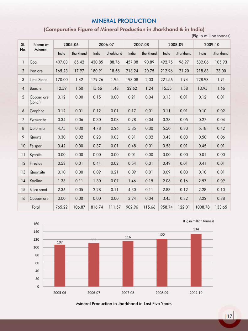
MInErAL ProductIon(Comparative Figure of Mineral Production in Jharkhand & in India)
(Fig in million tonnes)
Sl. no.
name of Mineral
2005-06 2006-07 2007-08 2008-09 2009-10
India Jharkhand India Jharkhand India Jharkhand India Jharkhand India Jharkhand
1 Coal 407.03 85.42 430.85 88.76 457.08 90.89 492.75 96.27 532.06 105.93
2 Iron ore 165.23 17.97 180.91 18.58 213.24 20.75 212.96 21.20 218.63 23.00
3 Lime Stone 170.00 1.42 179.26 1.95 193.08 2.03 221.56 1.94 228.93 1.91
4 Bauxite 12.59 1.50 15.66 1.48 22.62 1.24 15.55 1.58 13.95 1.66
5 Copper ore (conc.)
0.12 0.00 0.15 0.00 0.21 0.04 0.13 0.01 0.12 0.01
6 Graphite 0.12 0.01 0.12 0.01 0.17 0.01 0.11 0.01 0.10 0.02
7 Pyroxenite 0.34 0.06 0.30 0.08 0.28 0.04 0.28 0.05 0.27 0.04
8 Dolomite 4.75 0.30 4.78 0.26 5.85 0.30 5.50 0.30 5.18 0.42
9 Quartz 0.30 0.02 0.23 0.03 0.31 0.02 0.43 0.03 0.50 0.06
10 Felspar 0.42 0.00 0.37 0.01 0.48 0.01 0.53 0.01 0.45 0.01
11 Kyanite 0.00 0.00 0.00 0.00 0.01 0.00 0.00 0.00 0.01 0.00
12 Fireclay 0.53 0.01 0.44 0.02 0.54 0.01 0.49 0.01 0.41 0.01
13 Quartzite 0.10 0.00 0.09 0.21 0.09 0.01 0.09 0.00 0.10 0.01
14 Kaoline 1.33 0.11 1.30 0.07 1.46 0.15 2.08 0.16 2.57 0.09
15 Silica sand 2.36 0.05 2.28 0.11 4.30 0.11 2.83 0.12 2.28 0.10
16 Copper ore 0.00 0.00 0.00 0.00 3.24 0.04 3.45 0.32 3.22 0.38
Total 765.22 106.87 816.74 111.57 902.96 115.66 958.74 122.01 1008.78 133.65
(Fig in million tonnes)
107111
116 122134
0
20
40
60
80
100
120
140
160
2005-06 2006-07 2007-08 2008-09 2009-10
Mineral Production in Jharkhand in Last Five Years

|18|
MInErAL BASEd InduStrIES In JHArkHAnd
Sl. no. type of Industry/Plant name of Industry/Plant district
1 ALUMINA Hindalco Industries Ltd., Muri Ranchi
2 ASBESTOS PRODUCTS Hyderabad Industries Ltd., Jasidih Deoghar
3
CEMENT
ACC Ltd., Chaibasa West Singhbhum
4 ACC Ltd., Sindri Dhanbad
5 Lafarge, Jojobera West Singhbhum
6 Lemos Cement, Khalari Ranchi
7 Sri Durga Cement Ltd., Hosla Ramgarh
8 Sone Vally, Japla Palamau
9CERAMIC
Bihar Industrial Corp. Ltd., Madhupur Deoghar
10 Maithan Ceramics Pvt. Ltd., Dhanbad Dhanbad
11 CHEMICALS Castic & Chemical Ltd., Garhwa Road Palamau
12 COPPER SMELTER HCL, ICC, Ghatsila West Singhbhum
13 FOUNDRYHindustan Malleables & Forgings Ltd. Jalan Nagar, Dhanbad
Dhanbad
14IRON & STEEL
Bokaro Steel Plant, Bokaro Bokaro
15 Tata Steel Ltd., Jamshedpur East Singhbhum
16 SINTERS & PELLETS Tata Steel Ltd., Noamundi West Singhbhum
17 PIG IRON Usha Martin Industries, Jamshedpur East Singhbhum
18
SPONGE IRON
Bihar Sponge Iron Ltd., Chandil Saraikela-Kharsawan
19 Jai Durga Iron Pvt. Ltd., Jhumari Tellaiya Koderma
20 Zoom Vallabh Steels Ltd., Dugdha Saraikela-Kharsawan
21 TIN PLATING The Tin Plate Co. of India Ltd., Jamshedpur East Singhbhum
22 GLASS IAG Co. Ltd., Bhandainagar Deoghar
23
REFRACTORY
Allied Refractories (P) Ltd., Amaghata
24Bharat Refractoreis Ltd., Marar, (Ranchi Road Refractories Ltd.)
Hazaribagh
25Bharat Refractoreis Ltd., Marar, (IFICO Refractories Ltd.)
Hazaribagh
26Bharat Refractoreis Ltd., Bhandaridah (Bhandaridah Refractory Plant)
Bokaro
27 Jharia Firebricks Pottery Works (P) Ltd., Dhansar Dhanbad
28 Mineral & Chemical Products, Kendposi West Singhbhum
29 Raj Refracrtory (P) Ltd., Hardag Ranchi

Chiria Iron Ore Deposit

Directorate of GeologyDepartment of Mines & Geology
Engineer’s Hostel No. - 2 Dhurwa, Ranchi - 834 004
2208
/10/
11 •
ww
w.k
aila
shpa
per.o
rg