Embed Size (px)
Citation preview

Government of the People’s Republic of BangladeshMinistry of Communications
Roads and Highways Department
ROAD CONDITION SURVEY MANUAL
NOVEMBER 2001

Ministry of Communication Road ConditionRoads and Highways Department Survey Manual
E:\Documents\Road Condition Survey Manual\Road Condition Survey Manual.docPage 2 (20)
Table of Contents1. ROADS...............................................................................................................................................................3
1.1 INTRODUCTION .....................................................................................................................................31.2 ROADS UNDER ROADS & HIGHWAYS DEPARTMENT..................................................................31.3 ROAD CLASSIFICATION........................................................................................................................3
1.3.1 National Highways .........................................................................................................................31.3.2 Regional Highways .......................................................................................................................41.3.3 Feeder Road...................................................................................................................................4
1.4 Road link...................................................................................................................................................41.4.1 Definition..........................................................................................................................................41.4.2 Same Road and Link number .....................................................................................................41.4.3 Link conditions ...............................................................................................................................41.4.4 Survey order ....................................................................................................................................5
1.5 Road COMPONENT...............................................................................................................................51.5.1 Road components .........................................................................................................................7
2. ROAD MAINTENANCE.....................................................................................................................................7
2.1 Why Maintenance....................................................................................................................................72.2 Type of Maintenance...............................................................................................................................7
2.2.1 Routine Maintenance ....................................................................................................................72.2.2 Periodic Maintenance....................................................................................................................82.2.3 Emergency Maintenance..............................................................................................................8
3. ROAD CONDITION SURVEY...........................................................................................................................8
3.1 A ROADS DESIGN LIFE.........................................................................................................................83.2 Road CONDITION SURVEY..................................................................................................................83.3 Why Road Condition Survey..................................................................................................................83.4 Data Collection........................................................................................................................................93.5 Surface Type ............................................................................................................................................93.6 HOW TO COLLECT FIELD DATA...................................................................................................... 103.7 RESPONSIBILITIES OF PERSONNEL INVOLVED........................................................................ 10
3.7.1 Role & Responsibilities............................................................................................................. 103.7.2 To be checked in the Office....................................................................................................... 11
4. ROAD DISTRESSES...................................................................................................................................... 12
4.1 Introduction............................................................................................................................................ 124.2 POTHOLES (RCS: COLUMN 2) ........................................................................................................ 124.3 Broken Edge (RCS: Column 3)......................................................................................................... 134.4 Cracking (RCS: Column 4) ................................................................................................................ 144.5 Rutting (RCS: Column 5).................................................................................................................... 154.6 Depression Area (RCS: Column 6).................................................................................................. 154.7 Raveling (RCS: Column 7)................................................................................................................. 164.8 HBB Road – Replace Bricks (RCS: Column 8) ............................................................................. 164.9 Earth Road – Regrade (RCS: Column 9)........................................................................................ 164.10 Shoulder Repair – Low and High (RCS: Column 10)................................................................... 164.11 Embankment – Left Repair & Right Repair (RCS 11 & 12)......................................................... 174.12 Side Drain – Repair (RCS Column 13) ........................................................................................... 17
5. PLANNING ROAD CONDITION SURVEY.................................................................................................... 18
5.1 ORGANISING ROAD CONDITION SURVEY (rcs) TEAM............................................................... 185.2 DUTIES OF TEAM MEMBERS............................................................................................................ 185.3 TRANSPORT FOR THE SURVEY..................................................................................................... 185.4 EQUIPMENT FOR THE SURVEY...................................................................................................... 195.5 DOCUMENTS, FORMS & STATIONERIES...................................................................................... 195.6 ADJUSTMENT OF ODOMETER......................................................................................................... 195.7 SAFETY.................................................................................................................................................. 20
APPENDIX 1 RCS-4 ROAD CONDITION SURVEY FORM

Ministry of Communication Road ConditionRoads and Highways Department Survey Manual
E:\Documents\Road Condition Survey Manual\Road Condition Survey Manual.docPage 3 (20)
1. ROADS
1.1 INTRODUCTION
A road network is a valuable Government asset and failure to maintain the roads thatform the network will lead to their rapid deterioration which in turn will lead toincreases in road user costs and accidents and the need for expensive re-construction works. Well-maintained roads make a valuable contribution towards thecountry’s economy.
This guide is accessible on the RHD Intranet.
1.2 ROADS UNDER ROADS & HIGHWAYS DEPARTMENT
The main road network of the country is under Roads and Highways Department(RHD). Maintenance of the roads including bridges is carried out by RHD. There isapproximately 20,850 km of roads under this department.
The road network capable to carry vehicles has increased significantly and isincreasing every year.
Bangladesh government realises the importance of road maintenance and the RHDhas given more emphasis on this subject. Only a few years back there was no properplanning and system for road maintenance. Therefore International agencies assistedthe Government of Bangladesh to address and solve the problem.
RHD has created an HDM Circle within the department. The HDM Circle will assistwith road maintenance planning and implementation by using modern technology."The Road Condition Survey" is a step forward for the government in order to achieveproper road maintenance.
1.3 ROAD CLASSIFICATION
The Roads and Highways Department (RHD) within the Ministry of Communications,is responsible for the management of approximately 20,850 km comprising threecategories of road classes; National, Regional and Feeder type ‘A’ roads.
1.3.1 National Highways
National Highways are defined as Highways connecting national capital with differentdivisional and old district headquarters port cities and international highways.
These roads have been categorised as National Highways considering the nationalimportance and geographical positions. Each National Highway has been provided

Ministry of Communication Road ConditionRoads and Highways Department Survey Manual
E:\Documents\Road Condition Survey Manual\Road Condition Survey Manual.docPage 4 (20)
with a name and a number, such as Dhaka-Chittagong Highway has been numberedN-1 whereas N stands for National. This number can only be changed by RHD headquarter.
1.3.2 Regional Highways
Regional Highways are defined as Highways connecting different regions and newdistrict headquarters not connected by National Highways Feeder Road.
Regional Highways are named after National Highways of national importance.Names and numbers of these highways are decided such as Comilla-Lalmai, R-140,whereas R stands for Regional meaning the Region. This number can only bechanged by RHD head quarter.
1.3.3 Feeder Road
Feeder Roads are defined as Roads connecting Upazila head quarters and otherimportant rural centres (growth centres) with the existing Road network.
These connecting roads are defined as Feeder Roads. There are two types of Feederroads. Feeder road - Type A and Feeder road - Type B. Name and numbers of theseroads are decided such as Akhaura-Agartala, F-1203 whereas F stands for feeder.
1.4 ROAD LINK
1.4.1 Definition
Every road has been divided into one or more links. Every link has got a link name anda number, such as Moulavibazar-Fenchuganj-Sylhet road, N-28 , which has got threelinks; (1) Moulavibazar-Rajnagar link no. 322, (2) Rajnagar- Fenchuganj link no.323, (3) Fenchuganj-Sylhet link no. 324.
1.4.2 Same Road and Link number
Some roads have not been divided in to more than one link. Road number and linknumber is same, such as Brahmanbaria-Lalpur, which has got road number F- 1210and also link number 1210.
1.4.3 Link conditions
Links are not dependent on distance. Links depend on important places, trafficvolume, road intersections and other factors. A link will be named and start with 0

Ministry of Communication Road ConditionRoads and Highways Department Survey Manual
E:\Documents\Road Condition Survey Manual\Road Condition Survey Manual.docPage 5 (20)
kilometres where it begins and proceed towards the next link and measure its lengthin kilometres. Thereafter the next link will also start with 0 kilometres and measure thelink length as previously described. The RHD head quarter has prepared these linksand provided them with a number. Therefore only the RHD head quarter is allowed tochange these.
1.4.4 Survey order
The Road condition survey should start from the beginning of the link name andproceed towards the end of the link name. If the survey is started from the oppositeside, it will not be useful. If any place or any bridge is mentioned by K.M. it means thedistance of the place or the bridge from beginning of that particular link.
1.5 ROAD COMPONENT
Different Road Components are shown in the figure on next page.

Ministry of Communication Road ConditionRoads and Highways Department Survey Manual
E:\Documents\Road Condition Survey Manual\Road Condition Survey Manual.docPage 6 (20)

Ministry of Communication Road ConditionRoads and Highways Department Survey Manual
E:\Documents\Road Condition Survey Manual\Road Condition Survey Manual.docPage 7 (20)
1.5.1 Road components
The road Embankment is build with earth. Earth is filled and Compacted up to therequired height. The Pavement is constructed on the top for traffic movement. Earthat the bottom of the pavement is called the Sub-grade. The Base Course is placedon top of it in two or more than two layers. Finally the Surface Course is placed ontop of it. The Shoulder on both sides of the pavement is for the pedestrian, lightvehicle movement and car park.
The Pavement has slopes on both sides from the centre of the road. This slope iscalled the Camber and has its own Camber Design. Sometimes this camber is alsocalled Crossfall. Each Embankment has Slopes on both sides according to thedesign. At the end of the toe of the Slope, the earth is prepared such so that theEmbankment remains stable. This part is called Berm.
2. ROAD MAINTENANCE
2.1 WHY MAINTENANCE
Of all the possible types of spending on the road network Preventive Maintenanceis the most beneficial. This is because a small amount of money on timelymaintenance can preserve the huge initial expenditure that was made at the time ofconstruction.
Maintenance expenditure saves money in two ways. Firstly it reduces the overallcosts to the roads agency (in this case the RHD). Secondly it reduces the costs tothe road users.
Maintenance is done to keep the vehicle operating cost lower. There will be lessaccident and the road will reach its design life when properly maintained. It will havesatisfactory level of economic rate of return.
2.2 TYPE OF MAINTENANCE
Preventive maintenance is usually classed as either Routine or Periodic. Routinemaintenance consists of minor works that must be carried out at frequent intervals,usually several times a year. Periodic maintenance consists of actions that must becarried out every few years
2.2.1 Routine Maintenance

Ministry of Communication Road ConditionRoads and Highways Department Survey Manual
E:\Documents\Road Condition Survey Manual\Road Condition Survey Manual.docPage 8 (20)
Pavement distresses occur due to vehicular traffic. Distresses are found in shoulderand slope due to rain, flood and other reasons. These essential maintenance worksshould be repaired on regular basis otherwise these in course of time becomes largein shape and size thereby difficult to repair. Repairing these types of distresses everyday on regular basis is known as routine maintenance.
2.2.2 Periodic Maintenance
The road requires surfacing work (Seal coat, Surface treatment) on top of thepavement surface within a gap of few years after doing typical routine maintenancework. There are different designs for this type of works. Sometimes a thick layer ofoverlay is done on the pavement. These types of works are called periodicmaintenance.
2.2.3 Emergency Maintenance
Emergency Maintenance can be defined as works to respond to natural calamitiessuch as flood, cyclone and earth slides etc. and prevent it from further damage.
3. ROAD CONDITION SURVEY
3.1 A ROADS DESIGN LIFE
A road is designed for a specific period of time and constructed accordingly. Forexample, the design period could be 20 years and it would be constructed up to anInternational standard, such as, Dhaka-Chittagong Highway. If the Engineer thinks thatthere will be no need for any maintenance work during this 20 years period, he will bemistaken. Each and every road requires maintenance. Routine maintenance shouldbe initiated directly after construction and continue on regular basis. Thereafterperiodic maintenance will come. By maintaining the road in this way it will reach itsrequired design life, and thereby beneficial from economic point of view.
3.2 ROAD CONDITION SURVEY
It is necessary to know the condition of the road every year for doing propermaintenance works. Accordingly road condition surveys is done to find out thecondition, and should be done every year at a particular time. The next paragraphs willdirect ways and procedure of the survey.
3.3 WHY ROAD CONDITION SURVEY
I. It is possible to find out the condition of the road by doing the survey, whetherthe road is Good, Fair, Poor or Bad.
Ministry of Communication Road ConditionRoads and Highways Department Survey Manual
E:\Documents\Road Condition Survey Manual\Road Condition Survey Manual.docPage 9 (20)
II. Effective road maintenance requires proper planning and budgeting. Byknowing the exact condition of the road this could easily be prepared and theGovernment can provide and distribute money accordingly.
III. HDM Circle receives the road condition survey reports, analyses it andconsidering an economic analysis by using HDM 4. This provides properplanning and feasible time period for periodic maintenance, rehabilitation andreconstruction work.
IV. HDM Circle provides correct information for higher level of planning.
V. Donor agencies are also interested in the HDM results, which enables them tofinance projects on proper basis.
VI. RHD can prepare a Road Data Book on the basis of these field data, whichwill be very useful for planning maintenance and development works.
3.4 DATA COLLECTION
All road links of the whole country need to be surveyed by using the RCS 4 form.
See Appendix 1.
The field level staff needs to collect the required data on this RCS 4 form.
3.5 SURFACE TYPE
Respective type of road surface is to be indicated by putting tick mark in the RCSform. Abbreviations and explanations for surface types are given below.
AC: Asphaltic Concrete – It is usually premixed material prepared in a plant andlaid by paving machine. For example Dhaka-Chittagong Highway or others.
ST: Surface Treatment – SBST (single seal surface treatment) or DBST (doubleseal surface treatment) is done on Highways as well as others bituminous or ACroads.
SC: Seal Coat – Seal coat is applied over the bituminous surface of the road. Put atick mark in the box if it is seal coat road.
CC: Cement Concrete – Though CC roads are not constructed at present but itwas done previously.
WB: Water Bound Macadam – Roads made with stone or brick aggregates rolledby spraying water.
HB: Herringbone Brick Bond – Roads made with HBB bricks over a layer of flatsoling.
ER: Earth Road – Roads constructed with earth.
UK: Unknown – There is an alignment for the road but no work has been done
Last Surfacing Year: Last Surfacing Year is to be provided in the form.

Ministry of Communication Road ConditionRoads and Highways Department Survey Manual
E:\Documents\Road Condition Survey Manual\Road Condition Survey Manual.docPage 10 (20)
3.6 HOW TO COLLECT FIELD DATA
The following information is to be examined or collected from the field.
• Fill in the required basic data on the RCS 4 form.
• Different types of distresses are shown and explained with pictures in thismanual. Use this information as a guide to collect correct data from field.
• This survey is generally for the top surface condition of the road. Cracks and otherdistresses can not be taken together at the same place at the same time.Potholes, edge breaks and patches can not be taken together and otherdistresses should be deducted from those areas.
• The Cross Section of pavement at left bottom of the form should be checked andthe dimensions ought to be taken at the start of each km.
• Each distress for 200 meters of the road should be noted and compared with thenext 800 meters travelled by vehicle. The difference compared to the first 200meters is to be noted in percentage or how much more/less in the figure.
• The distresses of each km should be recorded in the Kilometer Sheet. The surveyand its results will have an impact of the planning of the next year maintenancebudget.
• Fill in Name, Signature and Date
3.7 RESPONSIBILITIES OF PERSONNEL INVOLVED
3.7.1 Role & Responsibilities
The Executive Engineer (EE) and the Sub-divisional Engineer (SDE) engaged assupervisor should take the responsibility for the following:
• The Supervisors should verify if there are any changes in this year survey form. Ifchanges, these ought to be discussed and explained to their fellow workers.
• The Executive Engineer and Sub-divisional Engineer will check whether thesurvey team has any past experience or not. If found no, then it is required toorganise proper training. Thereafter the quality and understanding of the surveyshould be checked within one week after commencement.
• The Executive Engineer should check and verify all data before sending.
• The Executive Engineers are entirely responsible for the quality of the collecteddata in his respective division.
• The respective Sub-divisional Engineers are also responsible for their sub-divisional data.
• The Sub-Assistant Engineer (SAE) and the Work Assistant (WA) should beproperly trained before sending them to the survey.

Ministry of Communication Road ConditionRoads and Highways Department Survey Manual
E:\Documents\Road Condition Survey Manual\Road Condition Survey Manual.docPage 11 (20)
3.7.2 To be checked in the Office
• Last surfacing year
• The respective Executive Engineer and Sub-divisional Engineers should checkand verify all information in the boxes.
Each Sub-division should survey approximately 150 kms of road on average. It willrequire about 20 kms per day, in total ~ 8 days to complete the respective sub-division's survey.
It is necessary to complete and return the survey forms as early as possible. It shouldbe noted that these data will be used for next year maintenance plan and budget.

ROAD DISTRESSES
1.1 INTRODUCTION
Even when roads are constructed to the highest quality, over a period of time the roadwill show distress due to the effects of traffic wear, vehicle loads, climatic effects andother reasons. Road maintenance of this is required on a regular basis to keep theseeffects to a minimum, extend the life of the road and provide a high service to roadusers. Maintenance of all elements of the road is important but the condition of thepavement is the most important in predicting the performance of the road.
The major types of pavement distress to be recorded on RCS are described below.These are the principal condition indices that provide important information inpredicting the pavement, and hence the road, life which enables long term strategiesfor maintenance to be determined.
For the condition survey a form has been designed which will enable the majordistresses to be recorded when the form is correctly completed.

Ministry of Communication Road ConditionRoads and Highways Department Survey Manual
E:\Documents\Road Condition Survey Manual\Road Condition Survey Manual.docPage 12 (20)
4. ROAD DISTRESSES
4.1 INTRODUCTION
Even when roads are constructed to the highest quality, over a period of time the roadwill show distress due to the effects of traffic wear, vehicle loads, climatic effects andother reasons. Road maintenance of this is required on a regular basis to keep theseeffects to a minimum, extend the life of the road and provide a high service to roadusers. Maintenance of all elements of the road is important but the condition of thepavement is the most important in predicting the performance of the road.
The major types of pavement distress to be recorded on RCS are described below.These are the principal condition indices that provide important information inpredicting the pavement, and hence the road, life which enables long term strategiesfor maintenance to be determined.
For the condition survey a form has been designed which will enable the majordistresses to be recorded when the form is correctly completed.
4.2 POTHOLES (RCS: COLUMN 2)
Potholes usually develop in a surfacethat is either cracked, raveled or both.
The presence of water accelerates theformation of potholes both through ageneral weakening of the pavementstructure and through lowering of theresistance of the surface and basematerials to disintegration.
Potholes result from the loss ofsurface and base material in cracked,raveled or undamaged areas. Potholescan ONLY appear from Undamaged,Cracked or Raveled areas. An areathat has Broken Edge cannot beincluded as being Potholed.
Potholes can ONLY appear from Undamaged, Cracked or Raveled areas. An areathat has Broken Edge cannot be included as being Potholed.
Potholedeveloped fromcracking

Ministry of Communication Road ConditionRoads and Highways Department Survey Manual
E:\Documents\Road Condition Survey Manual\Road Condition Survey Manual.docPage 13 (20)
Potholes are recorded as theEquivalent Number of 0.3 m x 0.3 m,10 cm deep potholes (i.e. 10 litreseach). The majority of potholes inBangladesh are less than 10 cm indepth and hence some adjustmentshould be made for this whencalculating the number.
4.3 BROKEN EDGE (RCS: COLUMN 3)
Broken Edge can be defined as the loss of surface and base material at thepavement edge, caused by shear failure and attrition. This commonly arises onnarrow roads with unsealed shoulders, where vehicles pass on or close to apavement edge.
Broken Edge can appear from Undamaged, Cracked or Raveled areas.
Broken edge is recorded as the Equivalent Length of edge, average 30 cm wide, thatis missing over the section being surveyed.
Material lostfrom edge
Material lost fromboth edges
Standarddepth = 100 mm
0.3m
0.3m

Ministry of Communication Road ConditionRoads and Highways Department Survey Manual
E:\Documents\Road Condition Survey Manual\Copy of Road Condition Survey Manual.doc Page 1 (2)
4.4 CRACKING (RCS: COLUMN 4)
Cracking is one of the most important distresses in bituminous pavements. Fatigue,due to passage of traffic and ageing of the pavement binder are the principal factorscontributing to the cracking of a bituminous layer. The propagation of cracking isaccelerated through the embattlement of the binder material (bitumen) resulting fromageing and ingress of water, which can significantly weaken the underlying pavementlayers.
There are two types of cracking considered in the HDM:
Narrow cracks in surface due to theeffect of climatic or traffic damage:these are < 3mm in width
Wide cracks in surface and base due to weakness in pavement structure: these are> 3mm in width.
With a 3 mm wide crack, it would bepossible to easily insert a 3.5 inchfloppy disk on edge into the crack.When in doubt about the width, recordthe cracking as Narrow cracks ratherthan wide.
E:\Documents\Road Condition Survey Manual\Copy of Road Condition Survey Manual.doc Page 2 (2)
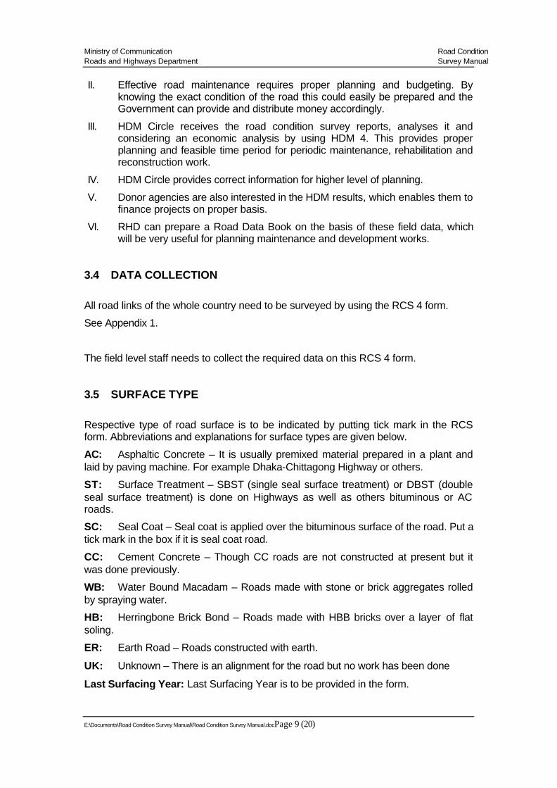
Cracks can ONLY appear fromUndamaged or Raveled areas.
An area that is Potholes or Patch cannotbe measured as cracked, raveled orBroken Edge. Areas of Narrow and Widecracks are independently measured asthe predominant area. Widely spacedcracks are measured as length x 0.5 m.Dense cracking is measured as areaonly.
In any location only one type of crack can be considered. Hence where two type ofcrack exist, Narrow or Wide, it is the most prevalent crack that is recorded.
The area of cracks is recorded as Square metres.
0.5m 0.5m
Width of area to bemeasured as cracked

E:\Documents\Road Condition Survey Manual\Copy of Road Condition Survey Manual.doc Page 1 (1)
4.5 RUTTING (RCS: COLUMN 5)
Rutting is defined as the permanent or unrecoverable traffic-associated deformationwithin pavement layers which, if channelled into wheelpaths, accumulates over timeand becomes manifested as a rut.
Rutting can exist with all other surface damage except Depressions.
Rutting is recorded as the total length of Rut occurrence in each wheelpath and ineach direction.
E:\Documents\Road Condition Survey Manual\Road Condition Survey Manual.docPage 15 (20)
Cracks can ONLY appear fromUndamaged or Raveled areas.
An area that is Potholes or Patch cannotbe measured as cracked, raveled orBroken Edge. Areas of Narrow and Widecracks are independently measured asthe predominant area. Widely spacedcracks are measured as length x 0.5 m.Dense cracking is measured as areaonly.
In any location only one type of crack can be considered. Hence where two type ofcrack exist, Narrow or Wide, it is the most prevalent crack that is recorded.
The area of cracks is recorded as Square metres.
4.5 RUTTING (RCS: COLUMN 5)
Rutting is defined as the permanent or unrecoverable traffic-associated deformationwithin pavement layers which, if channelled into wheelpaths, accumulates over timeand becomes manifested as a rut.
Rutting can exist with all other surface damage except Depressions.
Rutting is recorded as the total length of Rut occurrence in each wheelpath and ineach direction.
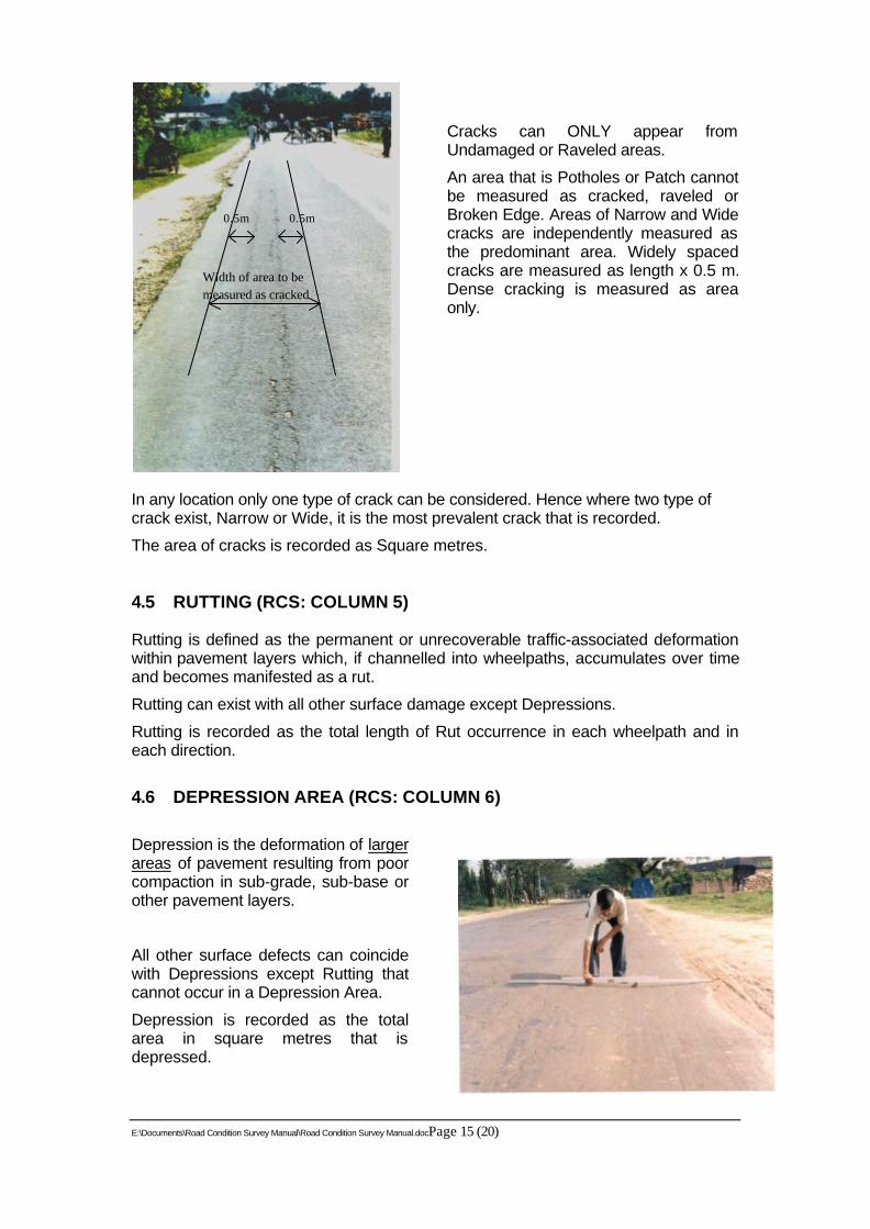
4.6 DEPRESSION AREA (RCS: COLUMN 6)
Depression is the deformation of largerareas of pavement resulting from poorcompaction in sub-grade, sub-base orother pavement layers.
All other surface defects can coincidewith Depressions except Rutting thatcannot occur in a Depression Area.
Depression is recorded as the totalarea in square metres that isdepressed.
0.5m 0.5m
Width of area to bemeasured as cracked

E:\Documents\Road Condition Survey Manual\Road Condition Survey Manual.docPage 16 (20)
4.7 RAVELING (RCS: COLUMN 7)
Raveling is the progressive loss ofsurface material through weatheringand/or traffic abrasion.
Raveling can ONLY appear in anUndamaged road or in a Patched area.An area of road that is Cracked,Potholes or Broken Edge cannot beincluded as a raveled area.
Recorded as the total area suffering surface damage not covered by Cracking,Potholes, Broken Edge or Patch in Square Metres.
4.8 HBB ROAD – REPLACE BRICKS (RCS: COLUMN 8)
This applies only to Herringbone Brick Roads. It is defined as the brick loss resultingfrom removal due to traffic damage or other causes. Is used to identify the area ofbricks to be replaced under the next year programme.
The Area requiring replacement of bricks in Square metres is recorded.
4.9 EARTH ROAD – REGRADE (RCS: COLUMN 9)
This is the need for a road to be reshaped resulting from deformation due to poorcompaction or due to traffic attrition and/or climatic damage.
The area requiring to be reshaped in square metres is recorded.
4.10 SHOULDER REPAIR – LOW AND HIGH (RCS: COLUMN 10)
The need for Shoulder Repairs result from climatic attrition or vehicle damage. Thecondition is reported as either High or Low:
This is reported as the total length of shoulder repair on both sides of the road.
High: where the level of the shoulder is raised above the edge of the road pavement.In this category the locations where surface water run-off is unable to escape fromthe shoulder should be recorded.

E:\Documents\Road Condition Survey Manual\Copy of Road Condition Survey Manual.doc Page 1 (1)
4.8 HBB ROAD – REPLACE BRICKS (RCS: COLUMN 8)
This applies only to Herringbone Brick Roads. It is defined as the brick loss resultingfrom removal due to traffic damage or other causes. Is used to identify the area ofbricks to be replaced under the next year programme.
The Area requiring replacement of bricks in Square metres is recorded.

E:\Documents\Road Condition Survey Manual\Copy of Road Condition Survey Manual.doc Page 1 (1)
4.9 EARTH ROAD – REGRADE (RCS: COLUMN 9)
This is the need for a road to be reshaped resulting from deformation due to poorcompaction or due to traffic attrition and/or climatic damage.
The area requiring to be reshaped in square metres is recorded.

E:\Documents\Road Condition Survey Manual\Copy of Road Condition Survey Manual.doc Page 1 (1)
4.10 SHOULDER REPAIR – LOW AND HIGH (RCS: COLUMN 10)
The need for Shoulder Repairs result from climatic attrition or vehicle damage. Thecondition is reported as either High or Low:
This is reported as the total length of shoulder repair on both sides of the road.
High: where the level of the shoulder is raised above the edge of the road pavement.In this category the locations where surface water run-off is unable to escape fromthe shoulder should be recorded.
Low: where the level of the shoulder,or edging, adjacent to the pavement ismore than 5 cm below the edge of theroad pavement. In addition localisedareas which are low and will causeponding of surface water should beconsidered as “Low” for the purposesof this definition.
>5 cm

E:\Documents\Road Condition Survey Manual\Copy of Road Condition Survey Manual.doc Page 1 (1)
4.11 EMBANKMENT – LEFT REPAIR & RIGHT REPAIR (RCS 11 & 12)
This may be defined as Erosion due to uncontrolled surface run-off or flood relateddamage. It can occur on any section of road on embankment.
The total length of embankment requiring repair is recorded for the left and Right sidein linear metres.

E:\Documents\Road Condition Survey Manual\Copy of Road Condition Survey Manual.doc Page 1 (1)
4.12 SIDE DRAIN – REPAIR (RCS COLUMN 13)
This may be defined as the length of side drain suffering from climatic damage due toclimatic effects and/or lack of maintenance where side drains are already inexistence.
The total length of drain in bad condition is recorded in linear metres.
Side Drainrequiring

Ministry of Communication Manual Traffic CountsRoads and Highways Department Instruction Guide
E:\Documents\Road Condition Survey Manual\Road Condition Survey Manual.docPage 18 (20)
5. PLANNING ROAD CONDITION SURVEY
5.1 ORGANISING ROAD CONDITION SURVEY (RCS) TEAM
One or more than one team conducts the road condition survey. The Team leader willeither be the Sub-divisional Engineer (SDE) or the Sub-Assistant Engineer (SAE).The SAE together with few work assistants (WA) will form each survey team. Moresurvey teams will be required if there are more roads. SDE will be responsible for allsurvey-related information. The Executive Engineer (EE) will co-ordinate all surveyworks under his each sub-division. He should ensure that all the roads are surveyedand each column of the survey sheet are filled in properly.
5.2 DUTIES OF TEAM MEMBERS
The Team leader is responsible for organising the survey work. He will explain andclarify the survey work to his staff members and how to conduct the work, whichtypes of instruments and equipment to use and how to fill in required forms. He alsohas the responsibility for the quality of the survey, examine whether the form has beenproperly filled or not. Each team member is responsible to fill in the form after takingthe correct measurement. The safety aspect has to be considered. The driver shallnote the odometer's reading and drive the vehicle at the defined speed.
5.3 TRANSPORT FOR THE SURVEY
The EE or the SDE will arrange a vehicle for the survey. A proper vehicle equippedwith the odometer should be used for the survey. A signboard with "Road ConditionSurvey" should be mounted in front and back of the vehicle for safety reasons.
Side Drainrequiring

Ministry of Communication Manual Traffic CountsRoads and Highways Department Instruction Guide
E:\Documents\Road Condition Survey Manual\Road Condition Survey Manual.docPage 19 (20)
5.4 EQUIPMENT FOR THE SURVEY
Each Sub-division have previously been provided with tools and equipment for thesurvey. The SDE is responsible for the tools and equipment. If any tool or equipmentis lost or found defective it should be replaced. The list of required tools andequipment are as follows:
• Hammer
• Chisel
• Brush
• Nylon string
• 15 meter tape
• 3 meter tape
• 1 meter long straight edge Wage
• Spirit level
• 1 meter square template
• Chalk
• Clip board
• File folder
• Torch with batteries
• Signboard
• Red flag
• Umbrella
5.5 DOCUMENTS, FORMS & STATIONERIES
The survey team should carry the following:
• Road Condition Survey Booklet
• One notebook and a few sheets of paper
• Pencil, eraser and clipboard
• Road map, list of roads with link name and number
• Pre-printed computer RCS forms for the road condition survey
5.6 ADJUSTMENT OF ODOMETER
The vehicles odometer should before the survey be checked and adjusted. Either avehicle or a motor cycle with a functional odometer can be used for the survey. Thelength will be measured with the odometer. There might be an error in the odometer

Ministry of Communication Manual Traffic CountsRoads and Highways Department Instruction Guide
E:\Documents\Road Condition Survey Manual\Road Condition Survey Manual.docPage 20 (20)
readings therefore it should be adjusted before beginning the survey. RCS Formshould be used for this adjustment.
Select a straight portion of a road with a km post. Put a mark “A” at the km post.Measure one km manually with a tape from this mark. After measuring one km againmeasure one km and put mark ”B” here. Bring the vehicle at “A”. Record theodometer reading in the RCS form at “A”. Start the vehicle at an uniform speed andstop it at “B”. Record the odometer reading at “B” and note it in the form. Deduct thefirst odometer reading from the second odometer reading and note it down. It will beprobable be seen that the odometer reading is more or less than two kms. The exactlength should be two kms. Suppose that the odometer reading is 2.03 kms. The figurewas the result after dividing the readings by 2, namely the “Correction FactorAdjustment”. (If time allows even better adjustment will be achieved if the readings aretaken of a length of ten kms.) The distance found in the odometer reading should thenbe multiplied with this Correction factor to get the correct distance.
5.7 SAFETY
In many roads the speed as well as the traffic volume is high. Special care should betaken for the safety of each member of the survey team on each road conditionsurvey. The use of red flags, signboard, survey caps, jersey, etc. should be promotedfor the survey. The Team Leader will have the overall responsibility for the safetyaspects.