Embed Size (px)
Citation preview

Securing Western Australia’s water future
Water resource protection seriesReport WRP 153
April 2016
Government of Western AustraliaDepartment of Water
Walpole Weir Catchment AreaWalpole Weir Catchment AreaDrinking water source protection review
Walpole town water supply- including Walpole Weir, Butler’s Creek Dam
and Swann Road bores


Walpole Weir Catchment Area drinking water source protection review Walpole town water supply – including Walpole Weir, Butler’s Creek Dam and Swann Road bores
Securing Western Australia’s water future
Department of Water
Water resource protection series
Report no. 153
April 2016

Department of Water 168 St Georges Terrace Perth Western Australia 6000 Telephone +61 8 6364 7600 Facsimile +61 8 6364 7601 National relay service 13 36 77 www.water.wa.gov.au
© Government of Western Australia
This work is copyright. You may download, display, print and reproduce this material in unaltered form only (retaining this notice) for your personal, non-commercial use or use within your organisation. Apart from any use as permitted under the Copyright Act 1968, all other rights are reserved. Requests and inquiries concerning reproduction and rights should be addressed to the Department of Water.
ISSN 1835-3924 (online)
ISBN 978-1-922248-82-4 (online)
Acknowledgements
The Department of Water would like to thank the following staff for their contribution to this publication: Kathryn Buehrig, Nicolie Sykora, Chris Qiu, Stephen Watson and Nigel Mantle (Department of Water) and Katrina Burton (Water Corporation).
For more information about this report, contact Water Source Protection Planning on +61 8 6364 7600 or [email protected].
Disclaimer
This document has been published by the Department of Water. Any representation, statement, opinion or advice expressed or implied in this publication is made in good faith and on the basis that the Department of Water and its employees are not liable for any damage or loss whatsoever which may occur as a result of action taken or not taken, as the case may be in respect of any representation, statement, opinion or advice referred to herein. Professional advice should be obtained before applying the information contained in this document to particular circumstances.
This publication is available at our website <www.water.wa.gov.au> or for those with special needs it can be made available in alternative formats such as audio, large print, or Braille.

Walpole drinking water source protection review WRP no. 153
Contents Summary .......................................................................................................................... iv
1 Review of Walpole’s drinking water source protection plan .......................................1
1.1 Update on Walpole’s drinking water supply ................................................................ 1 1.1.1 Treatment...................................................................................................................................... 1 1.1.2 Licensing....................................................................................................................................... 2 1.1.3 Water supply planning.................................................................................................................. 2
1.2 Hydrogeology .......................................................................................................... 3 1.2.1 Interpretation of hydrogeology for management of the bores .................................................... 3
1.3 Priority areas ........................................................................................................... 4 1.3.1 Department of Water land............................................................................................................ 4 1.3.2 Water Corporation land ................................................................................................................ 4
1.4 Protection zones...................................................................................................... 5 1.5 Native title claims and Aboriginal sites of significance ................................................. 5 1.6 Enforcing by-laws, surveying the area and maintenance ............................................. 5 1.7 Update on water quality risks .................................................................................... 6
1.7.1 Sw ann Road bores ....................................................................................................................... 6 1.7.2 Improved w ater source protection for Walpole Weir and Sw ann Road bores .......................... 7 1.7.3 Department of Parks and Wildlife land........................................................................................ 7 1.7.4 Department of Water land............................................................................................................ 8 1.7.5 Recreation..................................................................................................................................... 9 1.7.6 Feral pigs .................................................................................................................................... 10 1.7.7 Gravel pits ................................................................................................................................... 10 1.7.8 Future development ................................................................................................................... 10
1.8 Water quality information ........................................................................................ 16
2 Implementation of Walpole’s drinking water source protection plan .......................17
2.1 Status of previous recommendations ....................................................................... 17 2.2 Consolidated recommendations .............................................................................. 20
Appendices ......................................................................................................................22
Appendix A — Figures .................................................................................................... 22 Appendix B — Water quality data..................................................................................... 26 Appendix C — Photographs ............................................................................................ 33 Appendix D — How do we protect public drinking water source areas? ............................... 36 Appendix E — Understanding risks to drinking water quality............................................... 39
List of shortened forms ...................................................................................................40
Glossary...........................................................................................................................41
References ......................................................................................................................44
Further reading................................................................................................................46
Tables
Table 1 Summary of Walpole’s drinking water quality risks that are new or have changed since the 2007 plan............................................................................12
Table 2 Implementation status of recommendations from Walpole’s 2007 plan17
Department of Water iii

WRP no. 153 Walpole drinking water source protection review
Summary This document is a review of the Walpole Weir and Butler’s Creek Dam catchment areas drinking water source protection plan that was published in 2007 by the Department of Water. It updates information in the plan and discusses what has changed since then. Both of these documents are available on our website or by contacting us. They should be read in conjunction.
The major changes to Walpole’s drinking water supply since 2007 are:
• The Walpole Weir Catchment Area was proclaimed under the Country Areas Water Supply Act 1947 on 21 December 2007.
• Two new bores were installed along Swann Road that now supplement Walpole’s drinking water supply. These bores will require protection with wellhead protection zones.
• The Water Corporation is considering a new drinking water source for Walpole called Walpole Upper Stream. It is a surface water abstraction point along the Walpole River, upstream of the existing sources, with an associated off-stream water storage area. It has not been included as a source in this review because the necessary planning has not been undertaken, but it may need to be included in future reviews.
• Some lots that were privately owned have now been purchased by the Department of Water or the Water Corporation. Some of these can now be assigned priority 1 (P1) areas.
• Recommendations from the 2007 plan have been implemented.
In preparing this document, we consulted with key stakeholders; including land owners, Water Corporation, Shire of Manjimup and Department of Parks and Wildlife.
This review is consistent with the Australian drinking water guidelines (NHMRC & NRMMC 2011) and State planning policy no. 2.7: Public drinking water source policy (Western Australian Planning Commission 2003).
The following table shows important information about the Walpole Weir Catchment Area.
Key information about the Walpole Weir Catchment Area
Status of this report This report has been prepared based on information for the 2014/15 financial year
Local government authority Shire of Manjimup
Locations supplied Walpole town site, Boronia Ridge, Coalmine Beach Caravan Park and some surrounding farms
Water service provider Water Corporation
____________________________________________________________________________________________________________
iv Department of Water

Walpole drinking water source protection review WRP no. 153
Key information about the Walpole Weir Catchment Area
Capacities Butlers Creek Dam – 3283 kL (additional water available via run-of-the-river offtake)
Walpole Weir – no storage capacity (run-of-the-river)
Swann Road bores – 120 kL per day total (may be revised)
Aquifer type Bores target water within fracture zones, screened at 20–40 m deep. The overlying superficial aquifer is likely to be connected to the fractured rock aquifer, making the source vulnerable to contamination.
Abstraction point details
(See figures A3 and A4)
Bore A-26/08 (6 131 811 N, 473 314 E, zone 50)
Bore B-25/08 (6 131 807 N, 473 403 E, zone 50)
Butler’s Creek Dam (6 131 154 N, 476 779 E, zone 50)
Walpole Weir (6 130 547 N, 473 539 E, zone 50)
Dates of completion Swann Road bores completed in 2009, began supplying in summer 2011/12
Walpole Weir, concrete v-notch, constructed in 1985
Butler’s Creek Dam, earth wall dam, constructed in 1950
Dates of drinking water source protection reports
2000 – Draft Walpole Weir and Butler’s Creek Dam catchment areas water source protection plan
2007 – Walpole Weir and Butler’s Creek Dam catchment areas drinking water source protection plan
2016 – Walpole Weir Catchment Area drinking water source protection review (this document)
Consultation 2000 – advertised, public consultation
2006 – advertised, public consultation
2014 – key stakeholder consultation
Proclamation status Proclaimed on 21 December 2007 under the Country Areas Water Supply Act 1947
Department of Water v


Walpole drinking water source protection review WRP no. 153
1 Review of Walpole’s drinking water source protection plan
1.1 Update on Walpole’s drinking water supply
Walpole is located on the south coast of Western Australia (Figure A1). Walpole’s drinking water is sourced from Butler’s Creek Dam to the north-east of town, a weir on the Walpole River to the north-west of town, and two bores along Swann Road, North Walpole (Figure A3). These sources supply the Walpole town site, the nearby Boronia Ridge development, the Coalmine Beach Caravan Park and some surrounding farms.
Since the last plan was published in April 2007, most of Walpole’s water has been coming from Butler’s Creek Dam (Figure C1) with the Walpole Weir only used occasionally to make up the shortfall. In summer, river flows have been typically very low and in some recent years flow has stopped completely. This has forced the Water Corporation to cart water to supplement Walpole’s drinking water supply (Department of Water 2010). The weir has not been used since 2011, but remains an emergency source.
This led to the Water Corporation conducting a groundwater investigation in 2008 to find a more reliable drinking water supply for Walpole. As a result, two new production bores were constructed along Swann Road, North Walpole (A-26/08 and B-25/08; figures A3, C2 and C3). The pumping capacity of the two bores is 120 kL per day and they are used on a duty/standby basis (alternating pumping) during the summer months, when demand is highest. The bores were first used during the summer of 2011/12 and 4163 kL was abstracted over that period. Water has not been carted to Walpole since the bores came online.
Under the current regime, Butler’s Creek Dam is used solely until the dry season, when water is supplemented by the bores if required. The bores cannot be over-abstracted due to environmental constraints. If further water is required, it can be supplemented from Walpole Weir or by carting water.
During 2012/13, Butler’s Creek Dam supplied 54 761 kL and the bores supplied 1107 kL.
1.1.1 Treatment
Water from Butler’s Creek Dam, Walpole Weir and the Swann Road bores is treated at the same site – the Walpole Water Treatment Plant. The water treatment process stages are as follows:
• pre-treatment for iron and manganese (groundwater only) • caustic soda, alum and polyelectrolyte are used to balance pH and to enhance
flocculation and precipitation of impurities • a clarifying unit that removes turbidity and colour • filtered then stored in a 225 kL holding tank
Department of Water 1

WRP no. 153 Walpole drinking water source protection review
• ultraviolet treatment unit and chlorination for disinfection purposes.
The treated water is then transferred to a summit tank and gravitates through the town’s pipe network.
It should be recognised that although treatment and disinfection are essential barriers against contamination, public drinking water source area (PDWSA) management is the first step in protecting water quality and ensuring a safe drinking water supply. This approach is endorsed by the Australian drinking water guidelines (ADWG) (NHMRC & NRMMC 2011) and reflects a preventive risk–based, multiple-barrier approach for providing safe drinking water to consumers. This combination of catchment protection and water treatment will deliver a more reliable, safer and lower cost drinking water to consumers than either approach could achieve individually.
For more information on why it is so important to protect our catchments, please see Appendix D.
1.1.2 Licensing
The Walpole Weir Catchment Area is not located within a proclaimed groundwater or surface water area under the Rights in Water and Irrigation Act 1914 and therefore a licence is not required for abstraction. The only bores that require licensing are those that are drilled into the deep, confined aquifers. The Swann Road bores are not confined so a licence is not required.
1.1.3 Water supply planning
In December 2014, the Department of Water released the Great Southern regional water supply strategy. Its aim is to help achieve a secure water supply for the south coast area, including Walpole.
The strategy predicts that Walpole’s population will increase by 1–2 per cent per year, driving an increase in water demand of between 20 ML and 45 ML per year by 2043 (Department of Water 2014). A new water supply for Walpole is needed to ensure security of supply for current and future levels of demand.
The Water Corporation is currently working to develop a new water source for Walpole. In the meantime, water carting may still be required if low rainfall occurs before a new source comes online (Department of Water 2014).
In Water Forever: Lower Great Southern (2010), the Water Corporation included three potentially viable future drinking water sources for Walpole in its future sources portfolio. The details and status of these are:
• Walpole local groundwater – bores were installed along Swann Road and started operating in summer 2011/12.
• Samuels Brook Dam, potential for constructing a dam on Samuels Brook about 8 km north-west of Walpole – still under investigation.
• Seawater desalination, possible construction of a reverse osmosis seawater desalination plant, near Peaceful Bay – potential longer-term option.
2 Department of Water

Walpole drinking water source protection review WRP no. 153
A further option has been identified since the release of the Water Forever: Lower Great Southern, called Walpole Upper Stream. This option involves pumping water from the Walpole River near the airstrip into two off-stream storage basins located on land owned by the Water Corporation, north of Swann Road (Figure A3). The Water Corporation is now investigating this option as a priority.
The next review of Walpole’s drinking water source protection should include an update on these potential sources. If new sources are sufficiently developed by then, the Department of Water will need to consider water quality risks to those sources, and make adjustments to the PDWSA boundary, priority areas and protection zones accordingly.
Even if new sources are secured, it is likely that Walpole’s existing sources would continue to be used for emergencies and back-up, so the PDWSA boundary will remain the same at this time.
1.2 Hydrogeology
This section contains information about the hydrogeology of the area as described by Coffey Environments (2010), which was not included in the 2007 Walpole Weir and Butler’s Creek Dam catchment areas drinking water source protection plan.
The area around the Swann Road bores is underlain by granite and gneiss, and is part of the Kordabup land unit. This type of land unit has broad drainage floors in lower reaches of streams, with soil containing humus.
Groundwater is in a shallow, superficial aquifer of alluvial sand and organic material (to about 2 m deep) and then sand and clay (to about 10 m deep) which extends into the underlying weathered granite. Below about 19 m there is only slight weathering and at 23 m the granite is fresh. There are some fractures in the granite. The two production bores target groundwater in fracture zones between 20 m and 40 m below the ground.
During pump testing, measured drawdowns suggest that groundwater in the shallow, superficial aquifer and groundwater in the underlying fractured granite aquifer are connected. It is expected that groundwater in the superficial aquifer follows topographical contours and flows towards the Walpole River, south of the bores.
Water available from the bores is limited, due to environmental impacts that could arise if the bores are over-abstracted.
1.2.1 Interpretation of hydrogeology for management of the bores
It is likely that groundwater is flowing from the north, from land that is predominantly protected by state forest. However, the catchment also includes land with a rural zoning, used mainly for grazing. As the bores are drawing water from fractured rock that is connected to the overlying unconfined aquifer, they require wellhead protection zones to help protect them from immediate water quality contamination risks (see section 1.4).
Department of Water 3

WRP no. 153 Walpole drinking water source protection review
1.3 Priority areas
Since the release of the 2007 plan, several lots have been purchased by the Department of Water (1.3.1) and the Water Corporation (1.3.2). Some of these will change from priority 2 (P2) to priority 1 (P1) areas (Figure A4). Priority areas overlying private land will remain the same as in the 2007 plan. The Walpole Weir Catchment Area boundary will remain unchanged.
The priority areas have been determined in accordance with current departmental policy. If you require more information about how we protect drinking water sources, please see Appendix D.
1.3.1 Department of Water land
A recommendation of the 2007 plan was for the Department of Water to liaise with affected landowners about protecting water quality upstream of Walpole Weir:
‘Recommendation 12: The Department of Water liaise with affected landowners adjoining the Walpole Weir to determine how water quality can best be protected in these areas, including considering purchase options.’
Shortly after the release of the plan, the Department of Water started negotiations with a private landowner whose property abutted the Walpole River and drained directly into the Walpole Weir. This land was grazed by stock, causing a risk to water quality if pathogens entered the water source. Negotiations eventuated in the landowner selling a portion of their property to the Department of Water, that was then changed from a P2 to a P1 area, as stipulated in the 2007 plan (see Lot 87 in Figure A2). The land has since been destocked and the risk of pathogens contaminating the drinking water source has been reduced.
This plan recommends that the Department of Water investigates the potential for revegetating and rehabilitating low-lying and flood-prone areas on this land to improve water source protection (see section 2.2, recommendation no. 8).
1.3.2 Water Corporation land
The Water Corporation have purchased several lots since the release of the 2007 plan (Figure A2). These lots are:
• Lot 86 Swann Road, on both sides of the river • Lot 12737 north of Swann Road (includes the Swann Road bores) • Lot 10181 North Walpole Road • several lots along Chatley Road in the north of the catchment.
Most of these lots were used for grazing, and some remain under lease arrangements. Water Corporation should consider destocking and revegetating the land, pending the finalisation of long-term plans for Walpole’s future water supply, and wastewater planning. Any future plans for the land owned by the Water Corporation would need to be determined in consultation with the Department of Water.
4 Department of Water

Walpole drinking water source protection review WRP no. 153
The lots along Chatley Road in the north of the catchment will become P1 areas and lots 86, 12737 and 10181 will remain P2 areas, which is in accordance with their current use for grazing (Figure A4).
1.4 Protection zones
The new Swann Road bores require wellhead protection zones to protect them from immediate contamination threats. These wellhead protection zones will have a 300 m radius to reflect the P2 status of the land (Figure A4 and section 2.2, recommendation no. 1).
The wellhead protection zones have been determined in accordance with current Department of Water policy. If you require more information about how we protect PDWSAs, please read Appendix D.
1.5 Native title claims and Aboriginal sites of significance
Native title is the recognition in Australian law that some Aboriginal people continue to hold native title rights to lands and water arising from their traditional laws and customs.
The Department of Water is committed to working with Aboriginal people in its planning and management activities. The department recognises that native title is an important framework for water management.
There are three native title claims within the Walpole Weir Catchment Area:
• Single Noongar (WAD 6006/03) • Southern Noongar (WAD 6134/98) accepted for registration • Wagyl Kaip (WAD 6286/98) accepted for registration.
There are no Aboriginal sites of significance within the catchment area that are protected under the Aboriginal Heritage Act 1972.
Since the 2007 plan, a sign written in Noongar and English was erected in the Walpole Catchment Area, highlighting the importance of the waterways in the area to Aboriginal people (Figure C4).
1.6 Enforcing by-laws, surveying the area and maintenance
This review recommends that the Water Corporation continue by-law enforcement under the existing delegation arrangement. This also includes:
• erecting and maintaining signs in accordance with S111 Source protection signage (Water Corporation 2013)
• maintaining security and fencing surrounding the bores, weir and dam • ongoing regular surveillance and inspections
Department of Water 5

WRP no. 153 Walpole drinking water source protection review
• raising water quality incidents through the Advisory Committee for the Purity of Water.
A recommendation in the 2007 plan was for the Water Corporation to install signs along the boundaries of the catchment area to define its location and promote awareness of the need to protect drinking water quality. Since then, the Water Corporation, with the agreement of the Department of Water and other relevant agencies, has installed four new signs along the boundary of the Walpole Weir Catchment Area at the following locations:
• Angove Road • intersection of Centre Road and Angove Road • North Walpole Road • intersection of North Walpole Road and Bridge Road.
These signs will alert road users that they are entering a drinking water catchment area (Figure C5). There are also signs on the bore compounds that house the Swann Road bores.
The Water Corporation will also install one further sign at the airstrip service road (section 2.2, recommendation no. 5).
1.7 Update on water quality risks
As part of this review, we have conducted a new assessment of water quality contamination risks to Walpole’s drinking water source, in accordance with the ADWG. For more information on understanding risks in PDWSAs, please read Appendix E.
This section only discusses risks to Walpole’s drinking water quality that are new or have changed since the release of the 2007 plan. Please refer to the Walpole Weir and Butler’s Creek Dam catchment areas drinking water source protection plan (Department of Water 2007) for information about the unchanged risks that still apply. Table 1 (at the end of this section) summarises the risk assessment undertaken by the Department of Water. The risks are described in the following sections.
1.7.1 Swann Road bores
As the bores have been introduced as a new drinking water source since the release of the 2007 plan, the Department of Water has conducted a full water quality risk assessment in accordance with the ADWG. A summary of these risks is presented in Table 1.
The Swann Road bores are used during peak water demand (generally summer) and at other times as needed (e.g. for contingencies).
Bores drilled near a public drinking water supply bore (such as for irrigation or private purposes) can cause contamination of the drinking water source. For example, a poorly constructed bore may introduce contaminants from surface leakage down the outside of the bore casing into an otherwise uncontaminated aquifer.
6 Department of Water

Walpole drinking water source protection review WRP no. 153
It is therefore important to ensure that any bores are appropriately located and constructed to prevent contamination of the public drinking water source. All bores should be constructed in accordance with Minimum construction requirements for water bores in Australia (National Uniform Drillers Licensing Committee 2012).
As part of the Water Corporation’s project to find a new groundwater source for Walpole during 2008 and 2009, a contractor drilled 12 investigative bores within a 2 km radius of the Swann Rd bores. The Investigative drilling plan (Lowes Churchill & Associates Pty Ltd 2009) stated that successful bores would be cased, and unsuccessful bores would be abandoned, backfilled and the site restored. Two of the bores were converted to the production bores now known as A-26/08 and B-25/08, and it is understood that the remainder were backfilled in accordance with the drilling plan.
1.7.2 Improved water source protection for Walpole Weir and Swann Road bores
During 2008, the Department of Water’s South Coast Region funded a private landowner in the east of the catchment to undertake revegetation and install fencing and stock crossings. This work was completed successfully, reducing the risk of pathogens and nutrients entering the waterways from cattle grazing (Figure C6). This included lot 10181 (now owned by the Water Corporation) and lot 10180.
In April 2011, the South Coast Region used waterways funding to undertake works including fencing of waterways, installing watering points and constructing creek crossings within the Walpole Weir Catchment Area. The eastern tributary of the Walpole River was fenced at this time. This decreases the ability of pathogens and nutrients from stock grazing to enter the waterway, reducing the risk to drinking water quality.
Since the 2007 plan, the Department of Water and the Water Corporation have purchased some lots within the Walpole Weir Catchment Area (see Figure A2 and sections 1.3.1 and 1.3.2). Further, the previously unallocated Crown land surrounding the southern reaches of the Walpole River, directly upstream of the Walpole Weir, has now been vested with the Department of Water and incorporated into Reserve 31501. As part of this vesting process, a sign about ‘The Noongar Way’ was installed (Figure C4).
Some of this land has been destocked, reducing the risks to the weir and the bores. With cattle excluded from seasonally inundated areas the risk of pathogens entering the water source is now reduced. Water Corporation should investigate destocking the remainder of the land under their ownership to address water quality risks from pathogens in the catchment area (section 2.2, recommendation 8).
1.7.3 Department of Parks and Wildlife land
Since the 2007 plan, the Department of Environment and Conservation has split into the Department of Parks and Wildlife and the Department of Environment Regulation. The Department of Parks and Wildlife has responsibility for managing the state
Department of Water 7

WRP no. 153 Walpole drinking water source protection review
forest, national park and conservation areas within the Walpole Weir Catchment Area (Figure A2).
In 2008, the Walpole Wilderness and adjacent parks and reserves management plan was released (Department of Environment and Conservation 2008). The plan outlines the management status of the Department of Parks and Wildlife land within the Walpole Weir Catchment Area. Most of the land became part of the Mount Frankland South National Park, established on 8 December 2004. A small area in the south of the catchment is part of the Walpole-Nornalup National Park (originally gazetted in 1972), and the rest of the land is proposed forest conservation areas.
The key management direction for forest conservation areas in the Walpole Wilderness management plan is ‘to ensure that resource utilisation activities are sustainable, particularly in terms of their effect on flora of conservation significance.’ (Department of Environment and Conservation 2008). A range of sustainable uses are permitted in forest conservation areas, including wildflower picking, firewood collection and craftwood collection.
One of the proposed forest conservation areas is Crown reserve 31501, vested in the Department of Water (see 1.7.4).
No new public access roads are proposed within the Walpole Weir Catchment Area as part of the Walpole Wilderness and adjacent parks and reserves management plan. Access will be via existing roads only.
1.7.4 Department of Water land
The Walpole Wilderness and adjacent parks and reserves management plan (Department of Environment and Conservation 2008) proposes that Reserve 31501 (currently vested with the Department of Water for the purposes of water protection, see Figure A3) become a forest conservation area vested in the Conservation Commission. Activities such as firewood collection, wildflower picking, craftwood collection and beekeeping would be allowed, but timber production would not be permitted. The Department of Water has opposed this change of vesting to ensure that water source protection remains the primary purpose of the land.
The Department of Parks and Wildlife leases a portion of Reserve 31501 from the Department of Water. The leased area features an airstrip (see Figure A4) used primarily by the Department of Parks and Wildlife for fire control. It is also used for other emergency purposes including the Royal Flying Doctor Service, Silver Chain and Police. Occasionally, small, non-commercial planes use the airstrip on request. The Department of Parks and Wildlife Frankland District Manager has been granted power to exercise this discretionary approval. The Department of Water only supports the use of the airstrip for fire control and emergency purposes (section 2.2, recommendation no. 7). The Department of Water’s South Coast Region liaises with the Department of Parks and Wildlife in relation to management and use of the airstrip to ensure the ongoing protection of drinking water quality within the PDWSA.
8 Department of Water

Walpole drinking water source protection review WRP no. 153
1.7.5 Recreation
Swarbrick
There is only one recreation site within the Walpole Weir Catchment Area – Swarbrick. It is located near the north-eastern boundary of the PDWSA, off North Walpole Road (Figure A3). This is one of three sites that make up the Walpole Wilderness Discovery Centre.
Swarbrick was constructed in 2006 and features forest art exhibits and a 500 m walk trail through the old growth forest, and attracts approximately 7000 visitors per year. Gravel car parking and toilets are provided. The toilet is a two-cubicle, sealed-vault facility, and all waste is periodically pumped out and disposed of off-site to avoid contamination in the PDWSA.
Risks from this land use include pathogens from people and the toilet facility, and hydrocarbons from vehicles. Given the distance of Swarbrick from the drinking water offtake points, this land use has been assigned a medium management priority (Table 1).
Munda Biddi Trail
Since the release of the 2007 plan, the alignment of the Munda Biddi Trail was finalised. The trail is within the Walpole Weir Catchment Area, but follows existing roads (Angove Road) and trails. At its closest points, it is over 2 km away from the Swann Road bores and over 2.5 km away from the Walpole Weir (Figure A3). Trail users are not likely to pose a significant risk to Walpole’s drinking water supply. This land use has been assigned a medium management priority (Table 1).
Walpole Enduro motorcycle event
The Walpole Enduro event, run by the Denmark Motor Cycle Club Inc., has been held every second year in the catchment since the 2007 plan. There are approximately 100 participants (including competitors and officials) and it is not a spectator event. The route passes through the catchment a number of times, sometimes on existing roads and tracks, and other times off-road.
The Department of Parks and Wildlife’s predecessor requested an environmental management plan from the event managers to address issues such as temporary bridge construction over waterways, contingency planning (providing contact details for Water Corporation rangers), refuelling and waste disposal. No refuelling occurs within the catchment area and spill kits are provided.
The risks to water quality from motorcycle rallies include hydrocarbons and turbidity from the motorbikes, and pathogens and nutrients from the associated presence of people in the catchment. The Department of Water’s risk assessment process has therefore assigned the event a high management priority (Table 1).
According to Operational policy no. 13: Recreation within public drinking water source areas on Crown land (Department of Water 2012), previously approved motorsport is supported at September 2012 levels. Thus, no expansion of the event
Department of Water 9

WRP no. 153 Walpole drinking water source protection review
will be supported. The Department of Water and the Water Corporation would prefer that event organisers consider alternative routes outside of the PDWSA in future, to minimise the risk to drinking water quality and issues that may be associated with liability on Water Corporation owned land.
If the event is to be run again in the future within the PDWSA, event organisers need to complete Water quality information sheet no. 34: Application form for recreation events in public drinking water source areas on Crown land, available from the Department of Water’s website http://www.water.wa.gov.au/PublicationStore/first/106400.pdf.
1.7.6 Feral pigs
Water Corporation rangers have observed evidence of feral pig trapping on private land (in the P2 area) near the Angove Road sign. Feral pigs pose a risk to water quality through pathogens, nutrients and causing turbidity. This risk has been assigned a low management priority, because the numbers of pigs recorded is low (Table 1).
1.7.7 Gravel pits
During 2009, extraction of gravel from two pits adjacent to the Butler’s Creek Dam caused contamination to the water source through turbidity. Turbidity is an issue for drinking water quality because it not only affects the aesthetic properties of the water (taste and appearance), but it also masks the effectiveness of disinfection processes. The incident was investigated and resolved by installing bunds to prevent flow of turbid water into the dam. One of the pits has since been closed and is now grassed.
The gravel pits have been used by numerous parties including the Shire of Manjimup and Main Roads. There is very little good quality road-building gravel available in the area, so it is unlikely that the remaining pit will be closed. The Department of Water recommends that best management practices be employed when using the gravel pit to ensure the dam is protected from further such incidents. Water Corporation will continue to monitor the gravel pit as part of its regular catchment surveillance. This gravel pit has been assigned a medium management priority, due to the bunding and regular surveillance (Table 1).
1.7.8 Future development
In recent years, land east of the Walpole Weir within the P2 area has been purchased by property investors. There may be an expectation that this rural land can be developed given its close proximity to town. However, there is a tributary of Walpole River in this area that potentially connects to the river upstream of the weir. Any intensification of land use would therefore affect water quality near the weir. The Department of Water does not support intensification of land uses within P2 areas. Further, it is unlikely that the shire would support any rezoning in this area due to its P2 status and low land capability.
10 Department of Water

Walpole drinking water source protection review WRP no. 153
The Shire of Manjimup does not consider the expansion of the town site to the north to be appropriate. Land for town growth has been secured outside of the Walpole Weir Catchment Area in the Frankland rural-residential zoning and the Boronia Ridge development, and also through urban infill via residential subdivision within Walpole.
The Shire of Manjimup is currently updating their Local planning strategy 2003–2013. The shire does not foresee any changes to the zoning of land within the Walpole Weir Catchment Area. The Department of Water expects that special control area boundaries will be included in the updated version to accurately reflect the Walpole Weir Catchment Area boundary. Further, the Shire of Manjimup’s Town Planning Scheme No. 4 (Department of Planning 2010) should be amended to accurately reflect the Walpole Weir Catchment Area. The shire should refer the draft strategy to the Department of Water for formal comments.
There are no indications of any proposed intensification of land uses within the Walpole Weir Catchment Area.
Department of Water 11

WRP no. 153 Walpole drinking water source protection review
Table 1 Summary of Walpole’s drinking water quality risks that are new or have changed since the 2007 plan
Land use/activity
Hazard Comments Management priority
Best management practice guidance1
Recommendations
Risks to the Swann Road bores
Stockyard Pathogens and nutrients
Stockyard used intermittently.
Land is now owned by Water Corporation.
High WQPN no. 80: Stockyards
Water Corporation to investigate closure or relocation of the stockyard (section 2.2, recommendation no. 8).
Cattle grazing
Pathogens Some land has been destocked since the 2007 plan.
Some grazing land is now owned by Water Corporation.
High Water Corporation to investigate destocking land under their ownership (recommendation no. 8).
Diesel generator in bore A-26/08 compound
Hydrocarbons Generator is required to operate the bores (Figure C2).
High WQPN no. 60: Tanks for mobile fuel storage in PDWSAs
No new strategies recommended. Water Corporation to maintain current water quality protection regime (recommendation no. 6).
Road adjacent to bore compounds
Hydrocarbons Signs have now been installed to alert road users they are within a PDWSA.
High WQPN no. 44: Roads near sensitive water resources
Current Westplan-HAZMAT emergency response procedures (recommendation no. 4).
12 Department of Water

Walpole drinking water source protection review WRP no. 153
Land use/activity
Hazard Comments Management priority
Best management practice guidance1
Recommendations
Airstrip Hydrocarbons Airstrip is approximately 750 m from the bores.
Used primarily by the Department of Parks and Wildlife for fire control and by other users for emergency purposes. They occasionally allow small, non-commercial planes to use the airstrip on request.
Medium WQPN no. 44: Roads near sensitive water resources
WQPN no. 83: Infrastructure corridors near sensitive water resources
WQPN no. 65: Toxic and hazardous substances – storage and use
Department of Water and Department of Parks and Wildlife continue to liaise regarding drinking water source protection at the airstrip. Best management practices such as correct fuel and chemical storage should continue.
The Department of Water does not support any other uses of the airstrip (section 2.2, recommendation no. 7)
Munda Biddi trail
Pathogens Trail is over 2 km away from the bores.
No campsites within the catchment area.
Medium WQPN no. 81: Tracks and trails near sensitive water resources
No additional recommendations required.
Department of Water 13

WRP no. 153 Walpole drinking water source protection review
Land use/activity
Hazard Comments Management priority
Best management practice guidance1
Recommendations
Feral pigs Pathogens There are low numbers of pigs recorded.
Low WQPN no. 96: Pest animal management in PDWSAs
Water Corporation to continue current regime surveillance regime (recommendation no. 6). If feral pigs become an increasing problem, investigate a control program.
New risks to the Walpole Weir (since the 2007 plan)
Walpole Enduro event
Pathogens and hydrocarbons
Environmental management plan required by Department of Parks and Wildlife.
New rally events are incompatible in P1 areas.
High WQPN no. 100: Motorsport facilities near sensitive waters
Operational policy no. 13: Recreation within PDWSAs on Crown land
Event organisers to submit Application form for recreation events within PDWSAs prior to proposed future events.
Expansion will not be supported.
Consideration should be given to locating the event outside the PDWSA.
Swarbrick Pathogens and hydrocarbons
Sealed-vault toilets and gravel carparking provided for 7000 visitors per year.
Over 5 km from the weir.
Medium Operational policy no. 13: Recreation within PDWSAs on Crown land
No additional recommendations required.
14 Department of Water

Walpole drinking water source protection review WRP no. 153
Land use/activity
Hazard Comments Management priority
Best management practice guidance1
Recommendations
New risks to Butler’s Creek Dam (since the 2007 plan)
Gravel pits Turbidity Turbidity contamination occurred in 2009. One pit has been closed. Bunding now prevents turbid water from entering the dam.
Medium WQPN no 15: Extractive industries near sensitive water resources
Water Corporation to continue to monitor the gravel pits as part of its regular catchment inspections (recommendation no. 6).
1Water quality protection notes (WQPNs) are available <http://drinkingwater.water.wa.gov.au> scroll down to water quality protection notes, or see Further reading.
Department of Water 15

WRP no. 153 Walpole drinking water source protection review
1.8 Water quality information
The Water Corporation has provided updated water quality information for the Swann Road bores, Walpole Weir and Butler’s Creek Dam. This is shown in Appendix B.
In summary, the high turbidity levels from the bores are likely to come from iron and manganese which occur naturally in the local groundwater. The high microbiological contamination readings in the surface water sources are likely to be from surrounding land uses such as cattle grazing. The Water Corporation treats and disinfects the water to address these water quality issues before supplying to consumers (section 1.1.1).
16 Department of Water

Walpole drinking water source protection review WRP no. 153
2 Implementation of Walpole’s drinking water source protection plan
2.1 Status of previous recommendations
Table 2 Implementation status of recommendations from Walpole’s 2007 plan
No. Recommendation Comments
1 The Walpole Weir and Butler’s Creek Dam catchment areas should be proclaimed under the Country Areas Water Supply Act 1947. (Department of Water)
The Walpole Weir Catchment Area was proclaimed on 21 December 2007 under the Country Areas Water Supply Act 1947 and incorporates the catchment areas of the Walpole Weir, Butler’s Creek Dam, the capture zones of the Swann Road bores and the potential new water source storage area near the airstrip.
2 The Shire of Manjimup Town Planning Scheme should incorporate this plan and reflect the identified catchment area boundaries and priority classifications. (Shire of Manjimup)
Local planning scheme no. 4 (updated to include amd 7 GG 03/07/12) includes Walpole Weir Catchment Area as special control area no.5, and Butler’s Creek Dam Catchment Area as special control area no.6. It also discusses appropriate developments within PDWSAs and the requirement to refer development applications to the Department of Water. However the boundaries are incorrect. A recommendation to amend this is included in this review (section 2.2, recommendation no. 2).
Department of Water 17

WRP no. 153 Walpole drinking water source protection review
No. Recommendation Comments
3 All development proposals located in the catchment areas that are likely to impact on water quality and/or quantity, or are inconsistent with WQPN no. 25: Land use compatibility in public drinking water source areas or State planning policy no. 2.7: Public drinking water source policy should be referred to the Department of Water for advice and recommendations. (Department for Planning and Infrastructure, Shire of Manjimup)
Development proposals within all PDWSAs are referred to the South Coast Region office of the Department of Water.
This recommendation is ongoing and will be carried forward in this review (recommendation no. 3).
4 Signs should be erected along the boundaries of the catchment areas to define their location and promote awareness of the need to protect drinking water quality. Signs should include an emergency contact telephone number. (Water Corporation)
Signs have been installed at four different points where roads intersect the boundary of the Walpole Weir Catchment Area (Figure C5), and on the bore compounds. One remaining sign is to be installed at the airstrip (recommendation no. 5). See section 1.6 for more information. ‘The Noongar Way’ sign was also installed in 2010 as part of the vesting of unallocated Crown land to the Department of Water (Figure C4).
5 Incidents covered by Westplan – HAZMAT in the Walpole Weir and Butler’s Creek Dam catchment areas should be addressed through the following: (see 2007 plan for further details).
Emergency response in the catchment area is an ongoing requirement and the recommendation will be carried forward (recommendation no. 4).
6 Implementation of surveillance and by-law enforcement should be delegated to the Water Corporation as the government licenced water service provider for Walpole. (Water Corporation)
Delegation was completed in 2013.
Water Corporation continues to undertake surveillance and by-law enforcement and this recommendation will be carried forward (recommendation no. 6).
18 Department of Water
Walpole drinking water source protection review WRP no. 153
No. Recommendation Comments
7 Review the water quality monitoring program in light of the identified risks to the water sources to ensure key characteristic parameters are included. Routinely review water quality analysis results to detect any increasing trends. (Water Corporation)
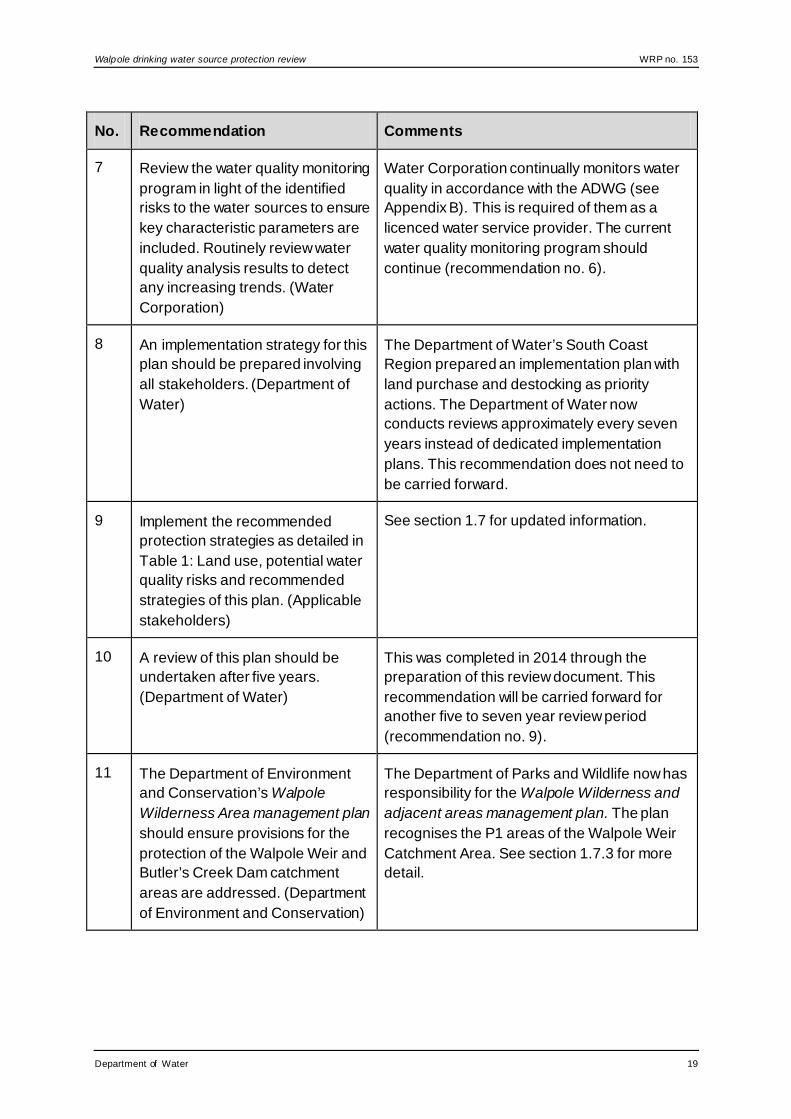
Water Corporation continually monitors water quality in accordance with the ADWG (see Appendix B). This is required of them as a licenced water service provider. The current water quality monitoring program should continue (recommendation no. 6).
8 An implementation strategy for this plan should be prepared involving all stakeholders. (Department of Water)
The Department of Water’s South Coast Region prepared an implementation plan with land purchase and destocking as priority actions. The Department of Water now conducts reviews approximately every seven years instead of dedicated implementation plans. This recommendation does not need to be carried forward.
9 Implement the recommended protection strategies as detailed in Table 1: Land use, potential water quality risks and recommended strategies of this plan. (Applicable stakeholders)
See section 1.7 for updated information.
10 A review of this plan should be undertaken after five years. (Department of Water)
This was completed in 2014 through the preparation of this review document. This recommendation will be carried forward for another five to seven year review period (recommendation no. 9).
11 The Department of Environment and Conservation’s Walpole Wilderness Area management plan should ensure provisions for the protection of the Walpole Weir and Butler’s Creek Dam catchment areas are addressed. (Department of Environment and Conservation)
The Department of Parks and Wildlife now has responsibility for the Walpole Wilderness and adjacent areas management plan. The plan recognises the P1 areas of the Walpole Weir Catchment Area. See section 1.7.3 for more detail.
Department of Water 19

WRP no. 153 Walpole drinking water source protection review
No. Recommendation Comments
12 The Department of Water liaises with affected landowners adjoining the Walpole Weir to determine how water quality can best be protected in these areas, including purchase options. (Department of Water)
The Department of Water and the Water Corporation have purchased land within the catchment area. See sections 1.3 and 1.7.2 for more information.
2.2 Consolidated recommendations
Based on the findings of this review, the following recommendations will now be applied to the Walpole Weir Catchment Area. The bracketed stakeholders are those expected to have a responsibility for, or an interest in, the implementation of that recommendation.
1. Create wellhead protection zones surrounding the Swann Road bores, and update the priority areas as specified in Figure A4. (Department of Water)
2. Correct the location of the Walpole Weir Catchment Area (including its priority areas and new protection zones) in the Shire of Manjimup’s local planning scheme in accordance with the Western Australian Planning Commission’s State planning policy no. 2.7: Public drinking water source policy. (Shire of Manjimup)
3. Refer development proposals within the Walpole Weir Catchment Area that are inconsistent with the Department of Water’s WQPN no. 25: Land use compatibility in public drinking water source areas or recommendations in this plan to the Department of Water regional office for advice. (Department of Planning, Shire of Manjimup, proponents of proposals)
4. Ensure incidents covered by Westplan–HAZMAT in the Walpole Weir Catchment Area are addressed by ensuring that:
• the Manjimup local emergency management committee and the Walpole sub-group are aware of the location and purpose of the Walpole Weir Catchment Area
• the locality plan for the Walpole Weir Catchment Area is provided to the Department of Fire and Emergency Services headquarters for the HAZMAT emergency advisory team
• the Water Corporation acts in an advisory role during incidents in the Walpole Weir Catchment Area
• personnel dealing with Westplan–HAZMAT incidents in the area have ready access to a locality map of the Walpole Weir Catchment Area and information to help them recognise the potential impacts of spills on drinking water quality. (Water Corporation)
5. Erect a sign in the vicinity of the airstrip to promote protection of the drinking water source, including an emergency contact telephone number, and maintain
20 Department of Water

Walpole drinking water source protection review WRP no. 153
this and other existing signs; in accordance with the Water Corporation’s S111 Source protection signage (2013). (Water Corporation)
6. Water Corporation should continue the current regime of water quality monitoring, maintenance of fencing, inspections and by-law enforcement. (Water Corporation)
7. The airstrip should only be used for fire fighting and emergency purposes, and best management practices to protect drinking water quality at the airstrip should be continued. (Department of Parks and Wildlife)
8. Investigate the potential for the following measures to improve water source protection:
• closing or relocating the stockyard (Water Corporation)
• destocking and revegetating purchased land (Water Corporation, Department of Water)
• fencing and revegetating the major tributary of the Walpole River (East Walpole River) upstream of the stock crossing. (Department of Water, Water Corporation)
9. Review this document after seven years, or sooner if a new source is developed. (Department of Water)
Department of Water 21

WRP no. 153 Walpole drinking water source protection review
Appendices
Appendix A — Figures
Figure A1 Walpole Weir Catchment Area locality map
22 Department of Water

Walpole drinking water source protection review WRP no. 153
Figure A2 Walpole Weir Catchment Area land tenure
Department of Water 23

WRP no. 153 Walpole drinking water source protection review
Figure A3 Walpole Weir Catchment Area aerial photograph
24 Department of Water

Walpole drinking water source protection review WRP no. 153
Figure A4 Walpole Weir Catchment Area priority areas and protection zones
Department of Water 25

WRP no. 153 Walpole drinking water source protection review
Appendix B — Water quality data
The information provided in this appendix has been supplied by the Water Corporation.
The Water Corporation has monitored the raw (source) water quality for Walpole in accordance with the requirements of the Australian drinking water guidelines (ADWG) (NHMRC & NRMMC 2011) and interpretations agreed to with the Department of Health. This data shows the quality of water in the public drinking water source area (PDWSA). The raw water is monitored regularly for:
• aesthetic characteristics (non-health-related) • health-related characteristics including:
health-related chemicals microbiological contaminants.
The following data represents the quality of raw water from Walpole Weir, Butler’s Creek Dam, and the Swann Road bores. In the absence of specific guidelines for raw-water quality, the results have been compared with the ADWG values set for drinking water, which defines the quality requirements at the customer’s tap. Any water quality parameters that have been detected are reported; those that on occasion have exceeded the ADWG are in bold and italics to give an indication of potential raw-water quality issues associated with this source. The values are taken from ongoing monitoring for the period December 2008 to November 2013.
It is important to appreciate that the raw-water data presented does not represent the quality of drinking water distributed to the public. Barriers such as storage and water treatment exist downstream of the raw water to ensure it meets the requirements of the ADWG.
For more information on the quality of drinking water supplied to Walpole refer to the most recent Water Corporation drinking water quality annual report at <www.watercorporation.com.au> What we do > Water quality > Water quality publications > Most recent Drinking water quality annual report.
Aesthetic characteristics
The aesthetic quality analyses for raw water from Walpole Weir, Butler’s Creek Dam and the Swann Road bores are summarised in the following tables. The bores are a new source that are only used in times of peak demand. As such, the groundwater data quality is limited, so it has been presented in a separate table to the surface water sources. The high turbidity readings from the bores are likely to come from iron and manganese that naturally occur in the groundwater.
26 Department of Water

Walpole drinking water source protection review WRP no. 153
Aesthetic detections for Butler’s Creek Dam and Walpole Weir
Parameter Units ADWG aesthetic guideline value*
Butler’s Creek Dam Walpole Weir
Range Median Range Median
Aluminium acid soluble mg/L 0.2 0.1–0.11 0.105 0.55# 0.55
Chloride mg/L 250 105–190 180 70–150 95
Colour – true TCU 15 <1–130 6 48–>200 >200
Hardness as CaCO3 mg/L 200 45–65 60 26–50 35
Iron unfiltered mg/L 0.3 0.04–3.2 0.22 0.54–7.2 1.4
Manganese unfiltered mg/L 0.1 <0.002–2.6 0.004 0.009–0.14 0.025
Silicon as SiO2 mg/L 80 5.7–12 9.1 4.5–8.5 7.4
Sodium mg/L 180 48–100 91 39–72 51
Sulfate mg/L 250 17–18 17 6–23 8.5
Total filterable solids mg/L 600 224–352 338 201–309 260
Turbidity NTU 5 0.1–100 1.3 <0.1–28 4.5
Department of Water 27

WRP no. 153 Walpole drinking water source protection review
Parameter Units ADWG aesthetic guideline value*
Butler’s Creek Dam Walpole Weir
Range Median Range Median
pH pH units
6.5 – 8.5 5.76–6.56 6.13 4.75–6.53 5.54
Copper mg/L 1 0.01–0.016 0.013 NS NS
Zinc mg/L 3 <0.02–0.04 <0.03 NS NS
* An aesthetic guideline value is the concentration or measure of a water quality characteristic that is associated with good quality water.
# Only one sample taken during the period of review.
NS Not sampled.
Aesthetic detections for Swann Road bores
Parameter Units ADWG aesthetic guideline value*
Bore B-25/08 Bore A-26/08
Range Median Range Median
Colour – true TCU 15 4–12 8 3–5 4
Iron (unfiltered) mg/L 0.3 14–15 14.5 9.8–14 11.9
28 Department of Water

Walpole drinking water source protection review WRP no. 153
Parameter Units ADWG aesthetic guideline value*
Bore B-25/08 Bore A-26/08
Range Median Range Median
Manganese (unfiltered) mg/L 0.1 0.2–0.24 0.22 0.14–0.2 0.17
Turbidity NTU 5 95–110 103 27–110 68.5
pH pH units 6.5–8.5 5.99–6.06 6.03 5.94–6.11 6.03
* An aesthetic guideline value is the concentration or measure of a water quality characteristic that is associated with good quality water.
Health-related chemicals
Raw water from Walpole’s sources is analysed for chemicals that are harmful to human health, including inorganics, heavy metals, industrial hydrocarbons and pesticides. Health-related parameters that have been detected in the sources are summarised in the following table. Again, the data for the Swann Road bores has been presented in a separate table.
Department of Water 29

WRP no. 153 Walpole drinking water source protection review
Health-related detections for Butler’s Creek Dam and Walpole Weir
Parameter Units ADWG health guideline value*
Butler’s Creek Dam Walpole Weir
Range Median Range Median
Manganese unfiltered mg/L 0.5 <0.002–2.6 0.004 0.009–0.14 0.025
Nitrite plus nitrate as N mg/L 11.29 0.28–0.97 0.44 <0.05–0.042 <0.05
Sulfate mg/L 500 17–18 17 6–23 8.5
Barium mg/L 0.7 0.018–0.065 0.055 0.007–0.025 0.012
Boron mg/L 4 <0.02–0.03 <0.02 <0.02–0.24 0.02
Copper mg/L 2 0.01–0.016 0.013 NS NS
Fluoride (lab) mg/L 1.5 <0.1–0.1 <0.1 <0.1–0.1 <0.1
Nitrate as nitrogen mg/L 11.29† 0.36–0.95 0.49 0.012–0.042 0.02
Nitrite as nitrogen mg/L 0.91 <0.002–0.014 <0.002 <0.002–0.024 0.015
* A health guideline value is the concentration or measure of a water quality characteristic that, based on present knowledge, does not result in any significant risk to the health of the consumer over a lifetime of consumption (NHMRC & ARMCANZ 2011). † A guideline value of 11.29 mg/L (as nitrogen) has been set to protect bottle-fed infants less than three months of age. Up to 22.58 mg/L (as nitrogen) can be safely consumed by adults and children over three months of age.
NS Not sampled.
30 Department of Water

Walpole drinking water source protection review WRP no. 153
Health-related detections for Swann Road bores
Parameter Units ADWG health guideline value*
Bore B-25/08 Bore A-26/08
Range Median Range Median
Manganese (unfiltered) mg/L 0.5 0.2–0.24 0.22 0.14–0.2 0.17
Department of Water 31

WRP no. 153 Walpole drinking water source protection review
Microbiological contaminants
Microbiological testing of raw-water samples from Walpole Weir and Butler’s Creek Dam is currently conducted on a weekly basis, and on a monthly basis from the Swann Road bores. Escherichia coli counts are used as an indicator of the degree of recent faecal contamination of the raw water from warm-blooded animals. A detection of E. coli in raw water may indicate contamination of faecal material through rainfall runoff from surrounding land uses into surface water sources; or for groundwater sources, via ingress into the bore, or recharge through to the aquifer (depending on aquifer type).
During the review period, positive E. coli counts were recorded in 92.3 per cent of samples from the weir and the dam. Approximately 57 per cent of these samples had E. coli counts greater than 20 MPN per 100mL. It is likely that the high counts are a result of rainfall runoff from surrounding land use into the water sources. Conventional treatment, in addition to ultrafiltration, UV and chlorination are in place to treat the water at Walpole before supply to consumers.
During the reviewed period, there were no positive E. coli counts detected in the bore samples.
32 Department of Water

Walpole drinking water source protection review WRP no. 153
Appendix C — Photographs
Figure C1 Butler’s Creek Dam looking north, photograph by N. Sykora,
Department of Water
Figure C2 Swann Road bore A-26/08, showing mobile diesel generator,
photograph by N. Sykora, Department of Water
Department of Water 33

WRP no. 153 Walpole drinking water source protection review
Figure C3 Swann Road bore B-25/08, photograph by N. Sykora, Department of
Water
Figure C4 The Noongar Way sign, photograph by M. Gangell, Department of
Water
34 Department of Water

Walpole drinking water source protection review WRP no. 153
Figure C5 Example of a sign in the Walpole Weir Catchment Area, photograph by
N. Sykora, Department of Water
Figure C6 Example of fencing work done to protect water quality, photograph by
L. Newman, Department of Water
Department of Water 35

WRP no. 153 Walpole drinking water source protection review
Appendix D — How do we protect public drinking water source areas?
The Australian drinking water guidelines (ADWG) (NHMRC & NRMMC 2011) outline how we should protect drinking water in Australia. The ADWG recommends a ‘catchment to consumer’ framework that uses a preventive risk–based and multiple-barrier approach. A similar approach is recommended by the World Health Organization.
The catchment to consumer framework applies across the entire drinking water supply system – from the water source to the taps in your home. It ensures a holistic assessment of water quality risks and solutions to ensure the delivery of a reliable and safe drinking water to supply your home.
A preventive risk–based approach means that we look at all the different risks to water quality. We determine what risks can reasonably be avoided and what risks need to be minimised or managed to protect public health. This approach means that the inherent risks to water quality are as low as possible. A multiple-barrier approach means that we use different barriers against contamination at different stages of a drinking water supply system.
The first and most important barrier is protecting the public drinking water source area (PDWSA) (the area from which water is captured to supply drinking water). If we get this barrier right, it has a flow-on effect that can result in a lower cost, safer drinking water supply. Other barriers against contamination include storage of water to help reduce contaminant levels, disinfecting the water (for example chlorination to inactivate pathogens), maintenance of pipes and testing of water quality. Another community benefit from PDWSA protection is that it complements the state’s conservation initiatives.
Research and experience shows that a combination of catchment protection and water treatment is safer than relying on either barrier on its own. That’s why this drinking water source protection report is important. We should not forget that ultimately it’s about protecting your health by protecting water quality now and for the future.
In Western Australia, the Department of Water protects PDWSAs by implementing the ADWG, writing reports, policies and guidelines, and providing input into land-use planning.
This drinking water protection report achieves elements 2 and 3 of the 12 elements in the ADWG recommended for protecting drinking water. It shows the PDWSA’s location, its characteristics, existing and potential water quality contamination risks, and makes recommendations to deal with those risks.
The Metropolitan Water Supply, Sewerage, and Drainage Act 1909 and the Country Areas Water Supply Act 1947 provide us with important tools to protect water quality in proclaimed PDWSAs. These Acts allow us to assess and manage the water quality contamination risks from different land uses and activities. The department works
36 Department of Water

Walpole drinking water source protection review WRP no. 153
cooperatively with other agencies and the community to implement this legislation and develop drinking water source protection reports. For example, the Western Australian Planning Commission has developed a number of state planning policies to help guide development in PDWSAs.
An important step in maximising the protection of water quality in PDWSAs is to define their boundaries, priority areas and protection zones to help guide land-use planning and to identify where legislation applies. There are three different priority areas. The objective of priority 1 (P1) areas is risk avoidance – ensuring there is no degradation of the water quality (for example over Crown land). The objective of priority 2 (P2) areas is risk minimisation – maintaining or improving water quality (for example over rural-zoned land). The objective of priority 3 (P3) areas is risk management – maintaining the water quality for as long as possible (for example, urban- or commercial-zoned land). Protection zones surround drinking water abstraction bores and surface water reservoirs so that the most vulnerable areas are protected from contamination.
With 129 proclaimed PDWSAs across Western Australia, the department prioritises the update of drinking water source protection reports (such as this document). Our aim is to update each report every five years. In some locations, more frequent updates may be required to address changing water quality risks and land uses. These updates allow us to make changes to the PDWSA boundary, priority areas and protection zones if required. They also allow solutions to new water quality risks to be considered.
There are three different types of drinking water source protection report – each providing for different needs. The following table shows the differences between the types of reports.
There is a fourth type of report – Land use and water management strategy – that performs the same functions as a drinking water source protection report. However, these strategies are prepared by the Western Australian Planning Commission (with input from the Department of Water) and are strategic documents that integrate land use planning with water management. There are currently land use and water management strategies for Gnangara, Jandakot and Middle Helena.
If you would like more information about the ADWG and how we protect drinking water in Western Australia, visit <http://drinkingwater.water.wa.gov.au> or refer to our Water quality protection note (WQPN) no. 36: Protecting public drinking water source areas. You can also contact the Department of Water’s Water source protection planning branch on +61 8 6364 7600 or email [email protected].
Department of Water 37

WRP no. 153 Walpole drinking water source protection review
Drinking water source protection reports produced by Department of Water
Drinking water source protection report
Scope and outcome
Consultation Time to prepare
Implement-ation table
Proclamation
Drinking water source protection assessment (DWSPA)
Desktop assessment of readily available information.
Targeted Up to 3 months
No Proclamation to protect water quality and guide land use planning can occur as a result of any type of drinking water source protection report.
Drinking water source protection plan (DWSPP)
Full investigation of risks to water quality building on information in the DWSPA.
Public 6–12 months
Prepared from recommend-ations in the DWSPA and/or information from public consultation.
Drinking water source protection review (DWSPR)
Review change in land and water factors and implementation of previous recommend-ations. Sometimes prepared to consider specific issues in a PDWSA.
Key stakeholders
Up to 3 months
Prepared from recommend-ations in the DWSPA or DWSPP.
38 Department of Water

Walpole drinking water source protection review WRP no. 153
Appendix E — Understanding risks to drinking water quality
The existing integrated land use planning and public drinking water source area (PDWSA) protection program is based on the findings of three parliamentary committee reports in 1994, 2000 and 2010 (see Further reading). Since 1995, this integrated program has resulted in the development of four Western Australian Planning Commission state planning policies. These planning policies recognise the importance of PDWSAs for the protection of water quality and public health.
This integrated program relies upon a preventive risk–based assessment process in each PDWSA through the development of drinking water source protection reports. It is important to understand how risks are assessed to appreciate the impact of development within PDWSAs.
Risk-based assessments normally focus on the acceptability of risks after mitigation (residual risks). For drinking water sources, a preventive risk–based assessment that considers both the maximum and residual risks is required. This means that in some cases, the maximum risks from land uses will still be considered unacceptable, even after mitigation has reduced the risk. This is a more conservative approach needed to protect the health of consumers.
Water quality risks are evaluated by considering the type and scale of a potential contamination event (consequence), together with the probability/frequency of that event occurring (likelihood). An understanding of this relationship will prevent the common misunderstanding that probability equals risk (see risk matrix below).
For example, just because a drinking water contamination incident has not occurred for many years (low likelihood) does not mean that the risk is low, because we also need to consider the consequence of that contamination when determining risk. Further, no previous detection of contamination is not proof that the risk is acceptable.
Risk matrix: Level of risk (from the Australian drinking water guidelines 2011)
Likelihood Consequences
Insignificant Minor Moderate Major Catastrophic
Almost certain Moderate High Very high Very high Very high
Likely Moderate High High Very high Very high
Possible Low Moderate High Very high Very high
Unlikely Low Low Moderate High Very high
Rare Low Low Moderate High High
Department of Water 39

WRP no. 153 Walpole drinking water source protection review
List of shortened forms ADWG Australian drinking water guidelines
ANZECC Australian and New Zealand Environment Conservation Council
ARMCANZ Agriculture and Resource Management Council of Australia and New Zealand
GL gigalitre
HAZMAT hazardous materials
kL kilolitre
km kilometre
m metres
mg/L milligram per litre
mL millilitre
MPN most probable number
NHMRC National Health and Medical Research Council
NRMMC Natural Resource Management Ministerial Council
NS not sampled
NTU nephelometric turbidity units
P1 priority 1
P2 priority 2
PDWSA public drinking water source area
TCU true colour units
Westplan–HAZMAT
Western Australian plan for hazardous materials
WQPN water quality protection note
40 Department of Water

Walpole drinking water source protection review WRP no. 153
Glossary Abstraction The pumping of groundwater from an aquifer, or the removal of
water from a waterway or water body. Aesthetic guideline value
The concentration or measure of a water quality characteristic that is associated with acceptability of water to the consumer, for example appearance, taste and odour (NHMRC & NRMMC 2011).
Aquifer An aquifer is a geological formation or group or formations able to receive, store and transmit significant quantities of water.
Australian drinking water guidelines
The National water quality management strategy: Australian drinking water guidelines 6, 2011 (NHMRC & NRMMC 2011) (ADWG) outlines acceptable criteria for the quality of drinking water in Australia (see this plan’s References).
Bore A bore is a narrow, lined hole drilled into the ground to monitor or draw groundwater (also called a well).
Catchment The area of land which intercepts rainfall and contributes the collected water to surface water (streams, rivers, wetlands) or groundwater.
Confined aquifer
An aquifer that is confined between non-porous rock formations (such as shale and siltstone) and therefore contains water under pressure.
Drinking water source protection report
A report on water quality hazards and risk levels within a PDWSA; includes recommendations to avoid, minimise, or manage those risks for the protection of the water supply in the provision of safe drinking water supply.
Effluent Effluent is treated or untreated liquid, solid or gaseous waste discharged by a process such as through a septic tank and leach drain system.
Fractured rock An aquifer where groundwater is present in the fractures, joints, solution cavities, bedding planes and zones of weathering igneous, metamorphic and deformed sedimentary rocks. Fractures rock aquifers are highly susceptible to contamination from land-use activities when aquifers crop-out or sub-crop close to the land surface.
Gigalitre A gigalitre is equivalent to 1 000 000 000 litres or one million kilolitres.
Department of Water 41

WRP no. 153 Walpole drinking water source protection review
Health guideline value
The concentration or measure of a water quality characteristic that, based on current knowledge, does not result in any significant risk to the health of the consumer over a lifetime of consumption (NHMRC & NRMMC 2011).
Hydrocarbons A class of compounds containing only hydrogen and carbon, such as methane, ethylene, acetylene and benzene. Fossil fuels such as oil, petroleum and natural gas all contain hydrocarbons.
Hydrogeology The study of groundwater, especially relating to the distribution of aquifers, groundwater flow and groundwater quality.
Hydrology The science dealing with water on the land, including such things as its properties, laws and geographical distribution.
mg/L A milligram per litre (0.001 grams per litre) is a measurement of something (such as salinity) in a solution.
Most probable number
Most probable number is a measure of microbiological contamination.
Nephelometric turbidity units
Nephelometric turbidity units are a measure of turbidity in water.
Nutrients Minerals, particularly inorganic compounds of nitrogen (nitrate and ammonia) and phosphorous (phosphate) dissolved in water which provide nutrition (food) for plant growth.
Pathogen A disease-producing organism that can cause sickness and sometimes death through the consumption of water, including bacteria (such as Escherichia coli), protozoa (such as Cryptosporidium and Giardia) and viruses.
Pesticides Collective name for a variety of insecticides, fungicides, herbicides, algicides, fumigants and rodenticides used to kill organisms.
pH A logarithmic scale for expressing the acidity or alkalinity of a solution. A pH below seven indicates an acidic solution and above seven indicates an alkaline solution.
Public drinking water source area
The area from which water is captured to supply drinking water. It includes all underground water pollution control areas, catchment areas and water reserves constituted under the Metropolitan Water Supply, Sewerage, and Drainage Act 1909 or the Country Areas Water Supply Act 1947.
Recharge Recharge is the action of water infiltrating through the soil/ground to replenish an aquifer.
42 Department of Water

Walpole drinking water source protection review WRP no. 153
Recharge area An area through which water from a groundwater catchment percolates to replenish (recharge) an aquifer. An unconfined aquifer is recharged by rainfall throughout its distribution. Confined aquifers are recharged in specific areas where water leaks from overlying aquifers, or where the aquifer rises to meet the surface.
Run-of-the-river scheme
A scheme that takes water from a flowing river. Water is taken directly from the source and there is no detention (storage) time.
Runoff Water that flows over the surface from a catchment area, including streams.
Treatment Application of techniques such as settlement, filtration and chlorination to render water suitable for specific purposes, including drinking and discharge to the environment.
True colour units
True colour units are a measure of degree of colour in water.
Turbidity The cloudiness or haziness of water caused by the presence of fine suspended matter.
Unconfined aquifer
An aquifer in which the upper surface of water is lower than the top of the aquifer itself. The upper surface of the groundwater within the aquifer is called the watertable. This is also known as a superficial aquifer.
Water quality Water quality is the collective term for the physical, aesthetic, chemical and biological properties of water.
Wellhead The top of a well (or bore) used to draw groundwater is referred to as a wellhead.
Wellhead protection zone
A wellhead protection zone is usually declared around wellheads in PDWSAs to protect the groundwater from immediate contamination threats in the nearby area.
Westplan–HAZMAT
State emergency management plan for hazardous materials emergencies.
Department of Water 43

WRP no. 153 Walpole drinking water source protection review
References Coffey Environments 2010, Hydrogeological assessment of proposed production
bores Swann Road, Walpole, unpublished report prepared for the Water Corporation, Coffey Environments Australia Pty Ltd, Albany.
Department of Environment and Conservation 2008, Walpole Wilderness and adjacent parks and reserves management plan, Management plan no. 61, Government of Western Australia, Perth, available www.dpaw.wa.gov.au.
Department of Planning 2010, Shire of Manjimup Local planning scheme no. 4, updated to include AMD 1 GG 26/07/2013, originally gazetted December 2010, Government of Western Australia, Perth, available www.planning.wa.gov.au > the planning system > local planning schemes > search ‘m’ for Manjimup.
Department of Water 2007, Walpole Weir and Butlers Creek Dam catchment areas drinking water source protection plan, Government of Western Australia, Perth, available http://www.water.wa.gov.au/PublicationStore/first/61317.pdf.
——2014, Great Southern regional water supply strategy, Government of Western Australia, Perth, available http://www.water.wa.gov.au/PublicationStore/first/108261.pdf.
Government of Western Australia 1914, Rights in Water and Irrigation Act, State Law Publisher, Perth.
——1947, Country Areas Water Supply Act, State Law Publisher, Perth.
——1972, Aboriginal Heritage Act, State Law Publisher, Perth.
Lowes Churchill & Associates Pty Ltd 2009, Investigation drilling plan, C-W00441 Walpole source, Revision 2, 4 May 2009, unpublished report prepared for the Water Corporation, Bunbury, Western Australia.
National Health and Medical Research Council (NHMRC) & Natural Resource Management Ministerial Council (NRMMC) 2011, National Water Quality Management Strategy: Australian drinking water guidelines, Australian Government, Canberra, available https://www.nhmrc.gov.au/guidelines/publications/eh52.
National Uniform Drillers Licensing Committee 2012, Minimum construction requirements for water bores in Australia, 3rd edn, Australian Government National Water Commission, Braeside, Victoria, available www.water.wa.gov.au/PublicationStore/first/102386.pdf.
Shire of Manjimup 2003, Local planning strategy 2003 – 2013, endorsed by the Western Australian Planning Commission August 2003, Government of Western Australia, Perth, available http://www.planning.wa.gov.au/dop_pub_pdf/manjimup_local_planning_strategy.pdf.
44 Department of Water

Walpole drinking water source protection review WRP no. 153
State Emergency Management Committee 2009, State emergency management policy no. 2.4: District emergency management arrangements, as amended 12 April 2010, Government of Western Australia, Perth, available https://www.semc.wa.gov.au/policyandlegislation/policiesandplans/Administration/SEMP_2.4_-_District_Emergency_Management.pdf.
Water Corporation 2006, SG097 Source protection operations manual, Water Corporation, Leederville.
——2010, Water Forever: Lower Great Southern, final report, Water Corporation, Leederville, available http://www.watercorporation.com.au/~/media/Files/About%20us/Our%20strategies/Water-Forever-Lower-Great-Southern.
——2013, S111 Source protection signage, unpublished corporate standard, Water Corporation, Leederville.
Western Australian Planning Commission 2003, State planning policy no. 2.7: Public drinking water source policy, Government Gazette Western Australia, 10 June 2003, pp. 2077-82, Government of Western Australia, Perth, available www.planning.wa.gov.au.
World Health Organization 2004, Guidelines for drinking-water quality – Volume 1 – Recommendations, 3rd edn, World Health Organization, Geneva, http://www.who.int/water_sanitation_health/dwq/gdwq3rev/en/.
Department of Water 45

WRP no. 153 Walpole drinking water source protection review
Further reading Agriculture and Resource Management Council of Australia and New Zealand
(ARMCANZ) & Australian and New Zealand Environment and Conservation Council (ANZECC) 2000, Rural land uses and water quality – A community resource document, ARMCANZ & ANZECC, Canberra, available http://www.environment.gov.au/resource/rural-land-uses-and-water-quality-community-resource-document.
Board M (MLA Member for Jandakot and Chairman of the Select Committee) 1994, The Select Committee on Metropolitan Development and Groundwater Supplies – Report, Legislative Assembly, Perth, Western Australia.
Department of Health 2013, A guide to the use of pesticides in Western Australia – Providing information on legislation, policies and best practice, Government of Western Australia, Perth, available www.public.health.wa.gov.au/3/1139/2/pesticide_use.pm.
Department of Water & Department of Health 2008, Risks from pathogenic micro-organisms in public drinking water source areas, Government of Western Australia, Perth, available http://www.water.wa.gov.au/PublicationStore/first/82068.PDF.
Department of Water 2011, Living and working in public drinking water source areas, Government of Western Australia, Perth, available http://www.water.wa.gov.au/PublicationStore/first/97368.pdf.
——2012, Operational policy no.13: Recreation within public drinking water source areas on Crown land, Government of Western Australia, Perth, available http://www.water.wa.gov.au/PublicationStore/first/103823.pdf.
——2013, Water quality information sheet no. 34: Application form for recreation events within public drinking water source areas on Crown land, Government of Western Australia, Perth, available http://www.water.wa.gov.au/PublicationStore/first/106400.pdf.
——Water quality protection notes (WQPNs), Government of Western Australia, Perth, available www.water.wa.gov.au > publications > series browse > water quality protection notes.
2004, WQPN no. 25: Land use compatibility in public drinking water source areas
2006, WQPN no. 44: Roads near sensitive water resources
2006, WQPN no. 65: Toxic and hazardous substances – storage and use
2006, WQPN no. 80: Stockyards
2006, WQPN no. 81: Tracks and trails near sensitive water resources
2007, WQPN no. 83: Infrastructure corridors near sensitive water resources
46 Department of Water

Walpole drinking water source protection review WRP no. 153
2007, WQPN no. 100: Motor sport facilities near sensitive waters
2009, WQPN no. 96: Pest animal management in public drinking water source areas
2009, WQPN no. 36: Protecting public drinking water source areas
2013, WQPN no. 15: Extractive industries near sensitive water resources
2013, WQPN no. 60: Tanks for mobile fuel storage in public drinking water source areas.
Hrudey, SE & Hrudey, EJ 2004, Safe drinking water – Lessons from recent outbreaks in affluent nations, IWA Publishing, London.
National Health and Medical Research Council (NHMRC) & Natural Resource Management Ministerial Council (NRMMC) 2004, Water made clear – A consumer guide to accompany the Australian drinking water guidelines 2004, Australian Government, Canberra, available http://www.nhmrc.gov.au/_files_nhmrc/publications/attachments/eh33.pdf.
Sharp Hon C (MLC and Chairman of the Standing Committee) 2000, Report of the Standing Committee on Ecologically Sustainable Development in relation to the quality of Perth’s water supply, Legislative Council, Perth, Western Australia, available www.parliament.wa.gov.au.
Standing Committee on Public Administration, 2010, Report 11: Recreation activities within public drinking water source areas, Legislative Council, Perth, available www.parliament.wa.gov.au.
Department of Water 47


Department of Water168 St Georges Terrace, Perth, Western Australia
PO Box K822 Perth Western Australia 6842Phone: 08 6364 7600
Fax: 08 6364 7601www.water.wa.gov.au
10447 0 0416