Embed Size (px)
Citation preview

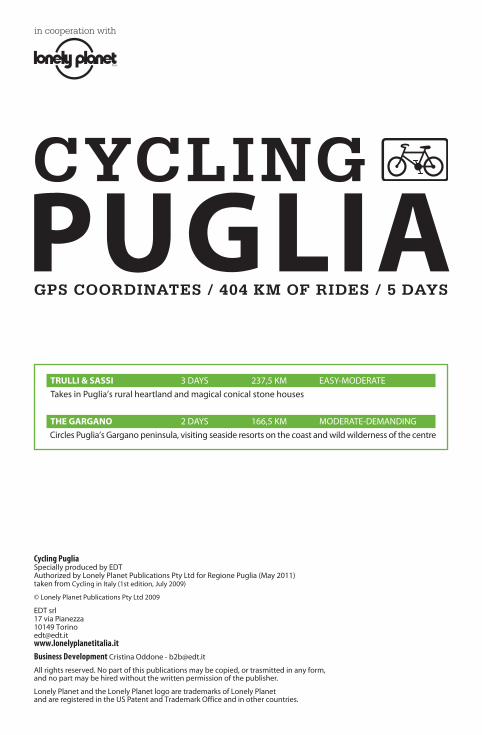
PUGLIA
in cooperation with
GPS COORDINATES / 404 KM OF RIDES / 5 DAYS
CYCLING

Maps, symbols and road signsThe routes described in this guide are accom-panied by maps showing the routes and the services offered, the interesting places to visit and the off-the-beaten-track sites. The most significant hills are shown with an altimetric profile. For more detailed maps, we advise you to buy specific maps.
The tables show the number of kilometres at which to turn, and the places and reference points along the route. Below is a key to these tables. The only other instrument that might be useful is a cyclocomputer.
CUE SHEET SYMBOLS
7 right-hand turn
6 veer right
8 continue straight on
9 left-hand turn
5 veer left
Bari town/city
0 caution
R side trip
P return
3 point of interest
< traffic light
; roundabout
HOW TO READ A CUE SHEET
start
climbs are graded as gradual, moderate, hard or steep
towns or cities along the ride are highlightedread: at roundabout turn left to Monte Sant’Angelo
read: at 32 km turn left for the side trip to Villaggio Umbra
THE GARGANO – DAY 2
CUES GPS COORDINATES
start Peschici, Piazza IV Novembre 41°56’51”N 16°00’52”E
7 Via Umberto I
0,1 9 to Rodi Garganico, Corso Garibaldi
1,5 7 to Rodi Garganico
2,7 5 to Vico del Gargano
3,9 0 2.2 km moderate climb
10,3 9 to Vico del Gargano
11,8 0 5.6 km hard climb
18,8 Vico del Gargano 41°53’46”N 15°57’35”E
9; to Monte Sant’Angelo
32 6 to Monte Sant’Angelo
{R5 to Vieste for Villaggio Umbra 1 km P}
FESTIVALS AND EVENTSThe Puglian festivals have always been magnificent occasions for enjoying the territory and ex-periencing its most profound soul, whether it is a question of celebrating a patron saint or a musical event. We have gathered many of the most important events on the calendar: they will be excellent companions for your days on the bicycle.
January Falò (11-12 January) At Castellana Grotte bonfires are lit to recall the miracle that freed the town from the plague in 1691.Sant’Antonio Abate (16 January) At Novoli a huge bonfire is lit to celebrate the hermit saint.
February Carnival – the most interesting is the one in Putignano, the longest-lasting in Italy: it begins on December 26th and ends on Shrove Tuesday. Great fetes also in Gallipoli, Massafra, Manfredonia and Molfetta.
March/April San Giuseppe (19 March) Great bonfires at Altamura, Bitetto, Faeto, Ginosa and in other towns in the province of Taranto.Easter – on Maundy Thursday at Ruvo in Puglia there is the Procession of the Eight Saints, while in Ginosa there is a very striking Via Crucis. On Easter Sunday, again in Ruvo, there is a great festival with the Procession of the Risen Christ.San Leone (6 April) the country fete of Bitonto, one of the most ancient in Italy, mentioned in the Decameron.San Giorgio (23 April) in Manfredonia the founding of the city is celebrated on the day of San Giorgio.Festa dell’Incoronata (last week in April) and the Cavalcata degli Angeli in Foggia, with children dressed as angels, saints and madonnas.
May San Nicola (7-8 May) great festival in Bari, parades, processions on the sea and music.San Cataldo (8-10 May) in Taranto, processions on the sea, fireworks and a mediaeval regatta.Open courtyards (end of May) in Lecce, the aristocratic palaces of the city open the doors of their courtyards.
JuneProcession of the Cavallo Parato (Sunday of Corpus Christi) a celebration dating from the sixteenth century: in Brindisi the archbishop carries the consecrated host on a white horse.Santi Pietro & Paolo (29 June) Galatina pays homage to the saints with a festival of taranta (traditional local music and dancing).Mediterranea Estate (June-September) a long series of free events throughout the summer, with concerts, comedians, theatre and dance – Lecce.
JulyDisfida di Barletta (22 and 23 July) the second historical pageant (the first is held in February) portraying the battle between the Italians and the French in 1503.Madonna del Carmine (16 July) Trani celebrates the protector of fishermen, laying floral crowns in the sea. Festival della Valle d’Itria (July-August) at Martina Franca, the renowned international festival with opera, classical music and jazz.San Nicola Pellegrino (last weekend in July) three days of celebrations for the patron saint of Trani.
AugustCorteo Storico di Federico II (second weekend in August) mediaeval procession at Oria, with a horse race between the four districts of the town.Festa dei Martiri idruntini (11-14 August) Otranto commemorates the martyrs of 1480. Notte della Taranta (late August) colossal concert of taranta (traditional local music and dancing)in the town of Melpignano. San Rocco (16 August) fireworks at Locorotondo. Sant’Oronzo (24-26 August) feast for the patron saint of Lecce, with processions, fireworks and music.La Cavalcata (26 August) at Ostuni processions of horsemen wearing brilliant red and white uniforms.
September San Teodoro (1-10 September) historical regatta, competitions between fishing boats and fireworks over the sea at Brindisi.Fiera del Levante (second Sunday in September) At Bari, the largest trade fair in southern Italy.
OctoberIntorciata (third Sunday of October) At Bitonto, procession in honour of the Medici saints Cosma and Damiano.
December Fiera di Santa Lucia (13-24 December) Christmas fair in Lecce and other towns, an excellent op-portunity to buy nativity scenes in papier-mâché and terracotta.Christmas – processions and events throughout the period of Advent. In many towns and villages there are living nativity scenes, but the most spectacular is in Crispiano, in the province of Taranto.
Cycling PugliaSpecially produced by EDT Authorized by Lonely Planet Publications Pty Ltd for Regione Puglia (May 2011)taken from Cycling in Italy (1st edition, July 2009)
© Lonely Planet Publications Pty Ltd 2009
EDT srl 17 via Pianezza 10149 [email protected] www.lonelyplanetitalia.itBusiness Development Cristina Oddone - [email protected]
All rights reserved. No part of this publications may be copied, or trasmitted in any form, and no part may be hired without the written permission of the publisher.
Lonely Planet and the Lonely Planet logo are trademarks of Lonely Planet and are registered in the US Patent and Trademark Office and in other countries.
GPS COORDINATES / 404 KM OF RIDES / 5 DAYS
CYCLINGPUGLIA
TRULLI & SASSI 3 DAYS 237,5 KM EASY-MODERATE
Takes in Puglia’s rural heartland and magical conical stone houses
THE GARGANO 2 DAYS 166,5 KM MODERATE-DEMANDING
Circles Puglia’s Gargano peninsula, visiting seaside resorts on the coast and wild wilderness of the centre
in cooperation with

2C
YC
LIN
G P
UG
LIA
Puglia
The bicycle is the right way to appreciate the variety and the beauty of Puglia. The elegance of Bari, the picturesque Valle d’Itria, the landscapes of the Gargano, with its cliffs, sandy beaches, whitewashed houses and the Foresta Umbra, without forgetting, of course, the charm of the Salento area: these attractions deserve more attention and the saddle of a bicycle is the perfect place from which to admire them. It is important to remember that over the last decade the Puglia Region has invested time and effort in enhancing its natural charm: the sea, the artistic heritage (the baroque buildings of Lecce, and much more), the traditions, the climate, the cuisine, the habit of welcoming visitors and culture of every sort. If you decide to travel the routes we suggest in this guide, you will soon understand what we mean. You will be enchanted, whether you visit a white trullo of Alberobello, a belvedere at Pugnochiuso or enjoy the generous fare of a trabucco.
The variety of landscapes and the welcoming atmosphere of the Gargano (p. 9)
The picturesque, almost surreal architecture of Puglia: the trulli of the Valle d’Itria (see p. 4) and the whitewashed houses of Vieste (p. 11)
The unforgettable flavours of a meal on the trabucchi, the fishing platforms that jut out over the sea like crabs.
SPECIAL EVENTS The feast of the three patron saints of Peschici (early July), with a procession through the mediaeval
quarter.
The Carpino Folk Festival (July-August): Italian folk music in Carpino, in the Gargano district.
The Valle d’Itria Festival (July-August): opera, classical music and jazz in Martina Franca.
CYCLE RACES The Giro di Puglia MTB, a mountain bike lap race, also open to touring bikes (March-October)
The Gran Fondo Circuito delle Colline di Monopoli (April): a circular race along the coast of Alberobello.
The Gran Fondo del Gargano (May): from Mattinata to the Foresta Umbra, a classic race of about 130km.
GASTRONOMIC HIGHLIGHTS Oil, wine, mutton, bread and fish, all prepared by the skilful Puglian chefs.
THE REGIONThe most characteristic trait of Puglia is the length of its coast: 800km lapped by the Adriatic and Ionian Seas, which corresponds to 10% of the entire Italian coastline. The inland areas are very varied, like the coast. There are dense forests, like the renowned Foresta Umbra, beautiful pastures and sunny plains that drop down towards sandy bays and cliffs. A paradise for cyclists, concentrated in the heart of a single Italian region.
NOT TO BE MISSED…
www.viaggiareinpuglia.it

lonelyplanet.comC
YC
LIN
G P
UG
LIA
3
PUGLIAThe ‘spur’ and ‘heel’ of Italy’s boot, Puglia is bordered by two seas, the Adriatic to the east and the Ionian to the south. Its strategic position as the peninsula’s maritime gateway to the east made it a major thoroughfare and a target for colonisers and invaders.
The ancient Greeks founded Magna Grae-cia, a string of settlements along the Ionian coast. Brindisi marks the end of the Roman Via Appia, which was completed around 190 BC and ran all the way to Rome.
The Norman legacy is seen in mag-nificent Romanesque churches across the region. Foggia and its province were fa-voured by the great Swabian king, Fred-erick II, several of whose castles remain. Spanish colonisers have also left their ar-chitectural mark, particularly in the prov-ince of Lecce.
Puglia’s predominant flatness makes it ideal cycling territory. In any case, pedal power offers a passage into many out-of-the-way parts of the province and can open otherwise closed doors into the world of the innately friendly southern Italians. Another indirect advantage is that cycling creates an appetite, and perhaps nowhere in Italy is the produce as fresh and the food as good as it is in Puglia.
This is one of southern Italy’s few easy rides, starting and finishing in Puglia’s capital, Bari, and traversing the region’s broad inland plains known as the Murge. It’s mostly flat, but the landscape manages to inspire rather than bore. It touches down in Basilicata, visiting Matera’s once infa-mous Sassi, then discovers the landscapes dotted with intriguing trulli. These quaint,
conical-roofed stone houses dot the richly cultivated countryside of the Murge (be-tween Noci and Locorotondo), a region with a justly deserved reputation as the ‘garden of Italy’.
PLANNINGWhen to CycleSummer heat can be oppressive in Puglia, es-pecially out on the open plains of the Murge. Ideal riding times are March to July and Sep-tember to November. If riding in the warmer months, plan to make an early departure to allow for siesta time during the hottest part of the day.
MapsTCI’s 1:200,000 Puglia map is fine, covering all but one or two of the minor roads (which aren’t shown on any other available maps of the area either).
GETTING THERE & AWAY Bari (start/finish)AIR Bari’s Palese Karol Wojtyla International Airport (BRI; %information 080 58 00 200, booking 080 58 00 204; www.aeroportidi puglia.it) is located 10km west of the city centre. It is serviced by a host of international, domestic and budget airlines. To get to the airport, take a train or the Cotrap bus (€4.15). Taxis wait outside the airport and the trip into town costs around €25, but you might have to search a bit to find one willing to shuttle a bike box.
BOATBari’s port (www.aplevante.it) is the principal port in the Adriatic. Ferries run to Greece, Albania, Croatia and Montenegro. Bicycles normally travel free.
BUSThe Ferrovie Appulo–Lucane (%08 057 25 229; www.fal-srl.it, in italian) services Altamura (€2.90, 1 hour, hourly) and Ma-tera (€4.50 1 hour 20 minutes, 10 daily). The south of Puglia is serviced by the Ferrovie del Sud-Est (%08 054 62 111, 800 079 090; www.fseonline.it, in italian). Every hour its tiny trains head for some of the most tourist-filled towns in Puglia, like Alberobello (€4.50 1 hour ½ hours) and Martina Franca (€4.50, 2 hours).
Duration 3 days
Distance 237.5km
Difficulty easy–moderate
Start/Finish Bari
Summary Flat riding on rural back roads past surreal architectural anomalies in stark, inspiring landscapes just got better: the food of Puglia makes your eyes roll back.
TRULLI & SASSI

lonelyplanet.comC
YC
LIN
G P
UG
LIA
4
TRAINBeing a transportation hub, Bari has buses to just about anywhere, but riding the train is easier with a loaded bike. The train sys-tem out of Bari can be confusing due to the various private and state railway services that operate. Note that Puglia is proudly the only region in Italy without the extra bike charge on its trains!
On Piazza Aldo Moro you’ll find the main train station (%89 20 21; www.ferroviedellostato.it), which is serviced by mainline trains connecting Bari with Milan (1st/2nd
class IC trains €86.50/64.50, 7½-10 hours), Rome (€57/41, 6 hours) and Foggia (€17/13, 1½ hours), where you can connect to Man-fredonia and the start of the Gargano ride. Be aware that bikes cannot be taken on Alta Ve-locità trains unless disassembled and packed. There are also trains to towns to the south like Brindisi (€7.70, 1¼ hours) and Lecce (€9.70, 1½–2 hours).
THE RIDEDay 1: Bari to Matera4½–8 hours, 78kmToday involves an almost imperceptible climb from sea level to 400m. Escaping Bari’s urban congestion is relatively quick and pain-free, with traffic thinning out after only a few kilometres. Beyond Ceglie del Campo (7.5km) – where you can pick up supplies from the morning produce mar-ket – the route heads south through olive groves to Adelfia (15.2km), a small rural
TRULLITrulli are circular or cube-shaped, stone hou-ses, conical-roofed and whitewashed, and built entirely without mortar. Their roofs are tiled with concentric rows of chiancarelle (evenly-shaped slate pieces) and topped with pinna-cles or spheres, which are often painted with astrological or religious symbols. Their origin is obscure, with suggestions of a connection to the Nuraghe of Sardinia, the bories of France and other similar structures in parts of Spain and Turkey.
The mortarless construction reputedly enabled feudal lords to deny the exploited peasants who tilled their lands any civil rights, by conveniently moving them on whenever necessary. Another theory is that the dry construction enabled rapid dismantling and rebuilding of the trulli, thereby sidestepping decrees forbidding the construction of towns by feudal lords without express royal permis-sion, and avoiding heavy imposts levelled on urban collectives.
The trulli area is in the Itria Valley. It ex-tends from Conversano and Gioia del Colle in the west to Ostuni and Martina Franca in the east. The greatest concentration of trulli is in and around Alberobello.
Within the more commercialised quarter of Rione Monti, on the south side of Alberobello (Unesco World Eritage site), more than 1000 trulli cascade down the hillside. To its east, on the other side of Via Indipendenza, is Rione Aia Piccola, with 400 trulli still mostly used as family dwellings. In the modern part of town, the 16th-century Trullo Sovrano (%08 043 25 482; Piazza Sacramento 10; h10-13 and 15.30-18 winter, 10-20 Easter-sep) has been converted into a small museum.
0 15 km0 10 miles
START & END
START: DAY 2
Bari
Matera
Side Trip
Side Trip
START: DAY 3
Side Trip
Airport
Grotte diCastellana
Torri di CastiglioneSaracen Tower
Torre Canne
Mottola
Rutigliano
Coreggia
Noci
Locorotondo
San Paolo
Palo delColle
Ceglie del Campo
Cassanodelle Murge
Capurso
Turi
Putignano
Gioia del Colle
Polignano
Corato
MartinaFranca
Ruvo diPuglia
Conversano
Mola di Bari
Terlizzi
Castellana Grotte
Gravinadi Puglia
ModugnoTriggiano
Castellaneta
Bitonto
Monopoli
Acquaviva delle Fonti
Fassano
Santeramo in Colle
Noicattaro
Altamura
Casamassima
Sammichele
Alberobello
Egnazia
Valled'Itria
A D R I A T I C S E A
SS235
SS99
A14
SS271
SS172
A14
A14
SS7SS7
SS53
E55
SS377
SS172
SS215
SS96
SS48
SS100
SS100
E55
E55
SS238
SS111 SS16
SS231
SS16
TRULLI & SASSI
Parco Sculturala Palomba
Santa Mariadella Palomba
MasseriaJesce

lonelyplanet.comC
YC
LIN
G P
UG
LIA
5
town boasting an original Norman tower, a lovely baroque palazzo with a clocktower, and a baroque archway to the town’s historic centre. Beyond Adelfia, your sense of space becomes expansive as the horizon stretches on forever and the rock-strewn land is given over to vineyards and fruit orchards.
Cassano delle Murge (30.1km) has a good little bakery, signposted just as you enter the town. Beyond Cassano delle Murge the minor road is a patchwork of repaired
potholes. It’s a little rough in places, but pleasant distractions are plentiful in this silent and harshly beautiful landscape of olive groves corralled by rock walls, and vast empty fields stretching away into a distant, hazy horizon.
Altamura (54.9km) is a large rural centre, and negotiating its maze of one-way streets can be confounding. The city was buildt in VI century BC, although human pres-ence in the area dates back to 400.000 years
0 15 km0 10 miles
START & END
START: DAY 2
Bari
Matera
Side Trip
Side Trip
START: DAY 3
Side Trip
Airport
Grotte diCastellana
Torri di CastiglioneSaracen Tower
Torre Canne
Mottola
Rutigliano
Coreggia
Noci
Locorotondo
San Paolo
Palo delColle
Ceglie del Campo
Cassanodelle Murge
Capurso
Turi
Putignano
Gioia del Colle
Polignano
Corato
MartinaFranca
Ruvo diPuglia
Conversano
Mola di Bari
Terlizzi
Castellana Grotte
Gravinadi Puglia
ModugnoTriggiano
Castellaneta
Bitonto
Monopoli
Acquaviva delle Fonti
Fassano
Santeramo in Colle
Noicattaro
Altamura
Casamassima
Sammichele
Alberobello
Egnazia
Valled'Itria
A D R I A T I C S E A
SS235
SS99
A14
SS271
SS172
A14
A14
SS7SS7
SS53
E55
SS377
SS172
SS215
SS96
SS48
SS100
SS100
E55
E55
SS238
SS111 SS16
SS231
SS16
TRULLI & SASSI
Parco Sculturala Palomba
Santa Mariadella Palomba
MasseriaJesce
delle Murge

lonelyplanet.comC
YC
LIN
G P
UG
LIA
6
ago (Uomo di Altamura), but it’s the 13th-century Cattedrale dell’Assunta that is of interest. The cathedral is in the old town’s main street, Corso Federico II di Svevia.
Also, don’t miss out on Altamura’s region-ally famous bread (pane di Altamura), which will send you straight into carb-loading heaven. Its hard exterior shields soft, thick insides that have an ever-so-slight hint of spice, maybe cinnamon. The route passes right by a few bakeries.
For a few short kilometres, the route traces the original Via Appia Antica (Appian Way), roughly between 60 and 70km, but visions of Roman centurions with clanging shields and sandalled feet quickly dissipate within the roar of traffic that’s not particularly heavy, but fast-moving. The route passes Parco Scultura la Palomba (75.5km; www.parcosculturalapalomba.it; under construction), an intrigu-ing display of gigantic, surreal works of art. Barinese Antonio Paradiso is in charge of this project that combines his scientific experi-ence in anthropology and palaeontology with visual art. The final run up to the day’s end at Matera involves one uphill grunt.
SIDE TRIP: MASSERIA JESCE 30 minutes–1hour, at 66.1km, 2.6km RTThis whole region is dotted with masserias, or old Italian farmhouses, that used to be the nuclei of rural farming communities. Many of them have been converted into agrituri-smi (farm stay accommodation). However, Masseria Jesce, once a medieval agricultural centre, has definitely not been converted to anything. Rather, it has given time free reign to dilapidate it into a fascinating relic. Believed to have been built between 1400 and 1550, this massive stone structure was intended to be a point of fortification for the community against possible threats brewing in an unsettled countryside.
Though the government intends it to be a historical site for tourists, that project has not manifested and you can wander about this decrepit edifice freely while taking in the stark landscape and imagining what it once must have been like.
SANTUARIO SANTA MARIA DELLA PALOMBA 30 minutes–one hour, at 75.5km, 1.6km RTOnce frequented by vagrants and shepherds who visited the frescoed Madonna Odigitria,
TRULLI & SASSI – DAY 1CUES GPS COORDINATES
Start Bari tourist office by train station 41°07'34''N 16°52'20''E
0km 9 Head east of station on Via Zuppetta
0.4 9 at T unsigned
7 (40m) Hard right at Piazza Luigi di Savoia
to underpass
0.6 7 at T
9 (60m) Viale Unità d’Italia, to ‘Stadio’
1.8 7 Viale Don Sturzo (which becomes Papa Giovanni XXIII)
2.3 9 Giulio Petroni
4.9 ; to ‘Carbonara, ospedale’
5.0 ; to ‘Carbonara, ospedale’
5.8 8 Continue straight at intersection
7.5 Ceglie del Campo 41°03'53''N 16°51'41''E
12.9 5 to ‘Adelfia’
15.3 9 to ‘Adelfia’
15.8 8 to ‘centro’ at stop sign
16.2 Adelfia 41°00’14’’N 16°52’05’’E
7 at clocktower
16.8 7 to ‘Bitritto’
5 to ‘Cassano delle Murge’ SP16
24.5 8 ‘to Cassano delle Murge’ (at ‘Stop’ sign)
31.2 8; ‘to Cassano delle Murge’
31.6 Cassano delle Murge 40°53’30’’N 16°46’16’’E
9 at T intersection
31.7 7 ‘to Matera, Santeramo in Colle’
32 9 ‘to Matera, Santeramo in Colle’
34.1 7 ‘to Altamura’
53.3 8< uphill
53.8 7 ‘to Bari, Matera, Gravina in Puglia’
54.2 9 ‘to Matera, Gravina in Puglia’
54.9 Altamura 40°49’46’’N 16°33’15’’E
54.9 5 ‘Matera, Corato’
55.1 9 Viale Martiri (not to ‘Matera’ to the right)
55.7 7 Tutte la direzioni, Via Carpentino
56.5 8 to LaterzaCUES CONTIES
63.4 8 to Laterza
66.1 9 to Matera SS9
R8 to side trip to Masseria Jesce up on left 2.6km RT.
69 8 to Matera
72.4 9 to Matera SS7
75.5 7 to Matera
3 Parco Scultura la Palomba
R9 to Santuario Santa Maria della Palomba
7 (1.6km) take first right after 20m
7 (0.3km) entrance is on the right}
75.5 9 to ‘Centro’
0 0.8km moderate climb
76.5 8 at stop sign to Palazzo Lanfranchi
77.1 6 merging with main road (Via Nazionale)
77.5 8 following information icon
77.9 7 following info icon on Via Roma
7 (10 meters) following info icon
78 9 following info icon
Matera, APT on left 40°40’02’’N 16°36’06’’E

lonelyplanet.comC
YC
LIN
G P
UG
LIA
7
this cave church (%08 353 30 287, telephone in advance to be sure that the keeper will wait you; Contrada Pedale della Palomba) dates back to the Byzantine era. Now there is a more recent church structure attached to what used to be just a sanctuary carved out of the cliff.
There are hiking trails into the gorge from the courtyard to other minor cave churches if you are up for that additional exercise. After the left turn off the route at 75.5km, follow signs to the church.
Day 2: Matera to Alberobello4–7 hours, 71.1kmThe first half of today’s ride heads back across the broad, gently rolling plains of the western Murge. Once you turn off the main road out of Matera, the soft hues of tilled soil and wheat crops mark the long stretch to Gioia del Colle. On warm days the silence may be broken by bizarre, squeaking crickets that do a masterful imitation of derailleur pulleys in dire need of oil. Don’t be surprised if you do a time-warp double-take as you pass a mule and cart.
Gioia del Colle (37.8km) is a large rural town with a supermarket, a greengrocer and several bars in the central piazza. From there, it’s a straight shot to the turn-off near Noci, which leads to possibly the most pleasant part of the day through pictur-esque trulli territory on other quiet back roads. It’s a gentle cruise to day’s end at Alberobello.
Day 3: Alberobello to Bari5–9 hours, 88kmThe last day might be the best of all, as the countryside becomes lusher and you wind your way via back roads through trulli country.
This day is a juicy example of why bicycle touring is one of the best ways to travel. In Alberobello, mobs of tourists flood in to see
TRULLI & SASSI – DAY 2CUES GPS COORDINATES
Start Matera, APT 40°40'02''N 16°36'06''E
0km head downhill
7 (20 meters) on Via De Viti de Marco
7 (20 meters) on Via Roma
0.3 7 at T at Stazione Matera
7< (30m) Viale Aldo Moro
0.5 6 Via Fratelli Rosselli
0.9 7; Via Stigliani, to ‘Bari, Taranto’
2.8 7< ‘to Bari, Taranto’
2.9 7 to ‘Taranto, Santeramo in Colle’
3.1 7 to ‘Santeramo in Colle’
6.5 9 to ‘Gioia del Colle’
17.6 7 to ‘Gioia del Colle’
20.7 8 to ‘Gioia del Colle’ at stop sign
36.8 9 to ‘Gioia del Colle’ centro
37.1 7 to ‘centro’ at stop sign
37.8 9 to ‘Bari’
Gioia del Colle 40°47'55''N 16°55'22''E
38.7 ; First exit to ‘Noci’
39.9 ;9 to ‘Noci’
40.8 at intersection, follow signs to Noci
40.9 5 at fork to ‘Noci’
56.9 7 to Mottola
8 if you want to go to Noci centro
57.2 ;9 to ‘Mottola’
57.6 8 to ‘Mottola’
58.1 9 to ‘Martina Franca’
58.4 7 to Martina Franca’
59.6 8 to Martina Franca’
60 5 NOT To Martina Franca, unsigned road
3 Vineria Barsento on Left, winery and restaurant
64.6 9 at T intersection at stop sign
65 7 at white trullo
67 9 at fork
70 8 to Centro at stop sign
70.3 5 to centro
70.7 6 Via Battisti
70.9 7 at intersection
71.1 Alberobello, Piazza Indipendenza 40°46'57''N 17°14'17''E

lonelyplanet.comC
YC
LIN
G P
UG
LIA
8
the trulli, and locals present them like ap-petizers. But roaming the rural countryside, you’ll see the trulli and realise how they blend with the well-tended orchards and vineyards of the vast landscape. You get a sense of what it might have been like to live in a trullo hun-dreds of years ago.
A short pedal north of Martina Franca is Locorotondo (17.5km), a completely circular town perched on a hill above the Valle dei Trulli. It takes only a minor diversion to ac-cess the charming, rambling streets and alleys of the centre, and it’s well worth the effort. It also offers a couple of fine restaurants serving delicious home-style food using the freshest local produce.
Leaving Locorotondo, the route continues to roll along quiet roads through undulating farmland marked by a noticeable absence of trulli. After the little one-bar village of Co-reggia (25.8km), the route heads onto busier roads, skirting Castellana Grotte (39.1km) and beginning the long, loping descent to the Adriatic Coast at Mola di Bari (64.4km) via Conversano (51.2km). Take the short 1km round-trip side trip to the Torre saracena di Castiglione (46.2km).
From Mola di Bari, the route is flat and moderately built up, and it hugs the coast for the most part.
Traffic density will vary somewhat depend-ing on the time of day and season, but it will
CUES CONTINUED GPS COORDINATES
40.5 7 ‘to Monopoli, Brindisi’ (at ‘Stop’ sign)
9 (50m) ‘to Polignano a Mare’
40.7 9 ‘to Polignano a Mare’
40.8 7 ‘to Polignano a Mare’ (at ‘Stop’ sign)
41.7 9 Via Vecchia, ‘to Conversano’
43.1 8 ‘to Torre Castiglione’
46.2 7 ‘to Conversano’
{R Saracen tower 1km P}
48 7 small road, industrial buildings on right
50.2 7 at T intersection
50.7 7 at T intersection
50.8 9 at T intersection
50.9 8; ‘to Conversano centro’
51.2 Conversano 40°58'03''N 17°07'02''E
51.5 7 at T intersection, ‘to Bari’
51.8 8; ‘to Bari, Rutigliano’
52.2 8 Via Bari (white sign)
53.2 ; 2nd exit, ‘to Rutigliano’
53.3 7 to ‘Centro di Valorizzazione’
57.2 9 ‘to Mola di Bari’
57.8 7 ‘to Mola di Bari’
58.5 7 ‘to Mola di Bari’
63.3 9 at T intersection
64.4 7 to ‘Cozze’ (not to Stadio)
8 to centro di Mola di Bari
65.6 9 at T intersection at waterfront
67.8 8 to ‘Torre a Mare’
69.6 ;8 to Torre a Mare (don’t get on highway)
74.7 7 Strada Scizze (right before highway entrance)
77.9 8 0.3km of gravel (head under arched overpass)
78.2 7 Via Abate Eustasio at stop sign
78.4 9< to ‘Bari Lungomare’
86.7 9< to ‘Stazione, Centro’ Corso Cavour
87.5 7< Via Prospero Petroni
87.7 9 Pedestrian/bike thruway, across from Piazza Umberto I
88 ; Bari, Stazione and APT tourist office 41°07'35''N 16°52'20''E
TRULLI & SASSI – DAY 3CUES GPS COORDINATES
Start Alberobello, Piazza del Popolo 40°47'06''N 17°14'21''E
0km Head Downhill on Via Fausto Arturo Cucci (flanks park on west)
0.1 9 at T unsigned ‘Largo Martellotta’
0.7 ;8 to ‘Locorotondo’
0.8 9 to ‘Locorotondo’
7 to ‘Locorotondo’
1.5 7 ‘to ‘Ristorante/Pizzeria Green Park’
2 9 Strada Acquarulo
9 9 to “Martina Franca’ at stop sign
9.5 5 to ‘Martina Franca’
12 9 ‘to Locorotondo’ (at ‘Stop’ sign)
{7R Martina Franca 4km P}
12.2 9 minor road before white trullo,
Cupa Rampone Strada
15.7 8 stay left of train line
16.7 7 uphill at T intersection
17.0 9< ‘to Fasano’
R8 to Locorotondo centro
17.8 5 not to Fasano
18.5 8 ‘to Contrada San Marco’ (right of little church) SP 162
18.6 9 ‘to Contrade Catuscio Nunzio’ (white sign) SC 190
23.4 6 no sign at roughly hewn roundabout
24.2 9 unsigned (green gate on drive-way to the right)
25 7 at T intersection, at stop sign
25.8 8 Viale Serenissima (at ‘Stop’ light)
28.3 9 ‘to Castellana Grotte, Putignano’
28.9 8 ‘to Putignano’ (at ‘Stop’ sign)
31.6 7 rock-walled lane, trullo on right
37.4 5 at fork
38.9 9 ‘to Castellana Grotte’
39.1 7 ‘to Monopoli, Polignano a Mare’
8 to Castellana Grotte cenrto
{8R Grotte di Castellana 6.6km P}
39.4 9 ‘to Monopoli, Polignano a Mare’
39.8 9 ‘to Brindisi, Monopoli, Polignano a Mare’

lonelyplanet.comC
YC
LIN
G P
UG
LIA
9
increase from what you’ve been accustomed to over the last couple of days, especially as you get closer to Bari. On the coastal stretch coming into Bari is a strip where locals buy cheap, fresh seafood and produce.
SIDE TRIP: MARTINA FRANCA 1 hour, at 12km, 4km RTThe short side trip to Martina Franca offers the chance to admire its well-maintained old quarter boasting some fine examples of baroque architecture. Founded in the 10th century by refugees fleeing the Arab inva-sion of Taranto, Martina Franca flourished from the 14th century, when it was granted tax exemptions (franchigie, hence the name Franca) by Philip of Anjou.
SIDE TRIP: GROTTE DI CASTELLANA 2–3hours, At 39.1, 6.6km returnThese spectacular limestone caves (%08 049 98 211, 800 21 39 76; www.grottedi castellana.it; Piazzale Anelli; full route/partial route €15-12) form Italy’s longest natural, subterranean network.
The interlinked galleries, with their breathtaking stalactite and stalagmite for-mations, were first explored in 1938 by the speleologist Franco Anelli: today’s visitors can follow his route in a guided group. After trudging down 265 steps (or taking the elevator) to a huge cavern known as ‘la Grave’, you pass through a series of caves, culminating in the magnificent Grotta Bianca.
The caves are only about 2km southwest of the main town and are well signposted. They’re open 9am–7pm daily, with tours on the hour. Bikes can be left at Hotel Autostello’s private car park (next to the caves’ entrance) at no cost if you purchase lunch at the hotel (www.hotelautostello.it).
This circuit of Puglia’s surprisingly un-spoilt Gargano Promontory, the ‘spur’ of the Italian boot, hugs the coast one day and traverses the mountainous interior the next.
The ride passes through a rich and amaz-ingly varied landscape of stark limestone terrain, cliffs falling to the sea, ancient for-ests and beautiful beaches. It’s a truly special place, and since public transportation here is not the most convenient, you as the cyclist have the unrivalled opportunity to explore this marvellous territory (while others look at you wistfully through the windows of ve-hicles).
While parts of the promontory bustle with tourists in summer, it doesn’t suffer from overcrowding or gross overdevelopment. The visitors seem to cluster and leave you the beautiful remainder. A midway stopover in the lovely little cliff-top village of Peschici offers seaside lazing and the option to ac-cess the superb beech and oak woods of the Foresta Umbra.
The terrain is hilly and the two days rela-tively long and arduous, but opportunities abound for those wishing to linger longer.
You could describe the Gargano as the low-key, second cousin of the Amalfi Coast, where you can experience a dramatic coast-line without the dramatic crowds.
Duration 2 days
Distance 166.5km
Difficulty moderate–demanding
Start/Finish Manfredonia
Summary In between bustling enclaves of beachgoers on the coast, you have a spectacular coastal ride. Inland, you’ll have diverse landscapes and wildernesses practically to yourself.
THE GARGANO

lonelyplanet.comC
YC
LIN
G P
UG
LIA
10
ENVIRONMENTThe Gargano Promontory was formed some-where between 70 and 180 million years ago, and is predominantly composed of dolomite, limestone and sedimentary rock. Traces of human habitation date back to the Neolithic Age.
The Parco Nazionale del Gargano in-cludes the Riserva Marina delle Tremiti (marine reserve of the Tremiti archipelago) and covers 121,118 hectares.
The park is home to a wide variety of important plant and animal species, includ-ing 170 of the 237 species of birds that ni-dify in Italy and 85 species of wild orchids. There are 27,000 hectares of predominantly broad-leaf forest (Italy’s largest), where 79 tree species such as the beech, ilex (holm oak), Turkey oak, cerris, ash and elm thrive. Coastal areas are dominated by native pines and Mediterranean maquis.
Significant and endangered native ani-mal and bird species include the capriolo italico (Italy’s own roe deer), which inhab-its the Foresta Umbra, the gallina prataiola (a small native bustard) found on the dry
fields of the foothills, and 5 species of pic-chio (woodpecker). The native wildcat, sev-eral other species of woodpecker, peregrine and lanner falcons, buzzards, kestrels, owls (including the rare eagle owl) and sparrow hawks also thrive in the sanctuary of the park.
PLANNINGWhen to CycleWhile the tourist flocks and high prices of the summer peak in August are best avoided, the beach aspect can be enjoyed during any of the warmer months. The promontory also offers pleasant cycling in spring and autumn, but winters are cold, wet (espe-cially on the northern side) and windy on the coast. If you’re riding on the weekend you’ll run into more lycra-ed cyclists than vrooming vehicles.
The Gargano is sprinkled with lodg-ing and lots of camp sites (check out www.camping.it), so this route can be extended into any number of enjoyable days. And don’t be afraid to explore roads off the route.
MapsTCI’s 1:200,000 Puglia map covers the ride.
GETTING TO/FROM THE RIDEManfredonia (start/finish)BUSTaking a bus means you don’t have to change trains, but there are only two daily SITA buses (€7.70, 1½ hours), leaving from Bari’s ATS Viaggi office. Ferrovia del Gargano and SITA also operate regular services between Foggia and Manfredonia (€2.60; 2 hours; frequent).
TRAINTrains connect Manfredonia with Foggia (€2.50 per bike and person; 30 minutes; 5 daily; tickets from Bar Impero, opposite the station), where FS services for many major cities stop, including Bari (first/second class €19.60/15.60, 2 hours).
THE RIDEDay 1: Manfredonia to Peschici5–9 hours, 86kmThis is a longish day accented by a number of climbs. The first, at 11.9km, is a moder-ate 3km at 5% not far out of Manfredonia.
0 6 km0 3 miles
Promontoriodel Gargano
MonteSacro
(872m)
Necropoli Salata
La Salata
VillaggioUmbra
RodiGarganico
Vico delGargano
MonteSant'Angelo
Peschici
Siponto
Pugnochiuso
Baia delleZagare
San Menaio
Ischitella
Mattinata
Porto diMattinata
Manfredonia
Vieste
A D R I A T I C S E A
Golfo diManfredonia
Baia diManaccora
Pizzomunno
THE GARGANO
RouteAlternative
Side Trip
START/END
START: DAY 2

lonelyplanet.comC
YC
LIN
G P
UG
LIA
11
After skirting Mattinata (18.7km) the road is smooth and wide, rising and falling dra-matically as it negotiates the rugged coastline, offering sensational panoramas down to the gleaming waters of the Adriatic.
The south coast of the promontory is noticeably drier and the vegetation sparser than on the northern side, so noon heat should be avoided. Rest assured, shady coastal pines bring welcome relief beyond 35km. There are numerous bars, restau-rants, hotels and camping villages (many of which are seasonal) dotting the route, so rest stops and accommodation options are never far away.
Vieste (60.3km) is a bright and very popular seaside resort, loaded with tourist facilities and boasting some great beaches. The IAT tourist office (%08 847 08 806; Piazza Kennedy; h8-13.30 Mon-Fri and 15-18.30 Tue and Thu Nov-Mar, h8-13.30 and 15-20 Mon-Sat Apr-May and Sep-Oct; h8-13.30 and 15-21 Jun-Aug) is an excellent source of information on the national park and places of interest on the promontory. Worth a look in the medieval quarter are the Chianca Amara (Bitter Stone), where thousands were beheaded when the Turks sacked Vieste in the 16th century, and the Museo Malacologico, exhibiting a collection of seashells from around the world.
On the flat stretch leaving town, the road passes an endless chain of unobtru-sive, low-level camping villages. At 70.3km there’s a small Roman ruin on the left near the church. At 71.8km (100m along the en-trance road to Camping Spiaggia Lunga), Sinergie (%08 847 06 635; www.agenziasinergie.it) conducts guided tours of the necropoli paleocristiana La Salata, under-ground tombs and burial grounds repre-senting the earliest evidence of Christianity in the region.
There are plenty of secluded bays and little beaches to explore along the final stretch to Peschici, which includes a series of short,
steep pinches and one last hefty climb at 78.3km to test weary legs.
Day 2: Peschici to Manfredonia4½–8 hours, 80.5kmAfter a short roll along the coast, today’s route heads inland and upward, starting with a hard 6km, then levelling out for a further 1km or so to Vico del Gargano (18.8km), a major agricultural centre. Encompassing two more moderate yet long climbs, the road
THE GARGANO – DAY 1CUES GPS COORDINATES
start Manfredonia, Piazza del Popolo 41°37’46”N 15°55’03”E
0km north on Corso Manfredi
0.3 9 Via Vittor Pisani
0.4 7 Via Tribuna
1.9 6 to ‘Mattinata’
11.9 7 ‘to Monte Sant'Angelo’
0 3km moderate climb
17.9 7 ‘to Vieste’
18.2 6 to ‘Mattinata’
18.7 8 to ‘Litoranea, Vieste’
or 9 to Mattinata Centro
22.3 0 2.3km moderate climb
29 7 to ‘Vieste’
29.9 pensione & camping
31.5 Villa Scapone
35.4 0 2.3km hard climb
39.7 0 3.6km moderate climb
49.5 camping village
60 7 to ‘centro, port’
60.3 7 Corso Lorenzo Fazzini
3 Vieste 41°53’02”N 16°10’36”E
60.6 5 Piazza Kennedy, to ‘Porto’
60.9 8 keep to road above coast
61.9 7< Peschici Litoranea
70.3 3 Necropoli La Salata
78.3 0 5.2km moderate-hard climbing
(1km break in middle of climb)
85.9 7 to info icon Via Pertini
Peschici
86 Peschici Tourist Office on corner of Piazza Sant'Antonio 41°56’50”N 16°00’51”E

lonelyplanet.comC
YC
LIN
G P
UG
LIA
12
maintains the exposed ridgeline, affording superb views down to Peschici and the coast before plunging into the leafy depths of the Foresta Umbra.
A short side trip (32km) to Villaggio Umbra leads to a museum and nature centre, and the leafy surrounds of the picnic areas,
kiosk and restaurant nearby make an ideal rest stop.
Back on the promontory’s southern side, the vegetation becomes markedly thinner and drier, slowly giving way to more open farmland as the road drops into the steep Valle Carbonara. The forbidding switchback up to Monte Sant’Angelo looks worse than it is, and after a steady, but exposed, 5km climb you’re in the town (60.7km).
The centre is just off the route. For use-ful tourist information go to the Pro Loco (%08 845 65 520; Via Reale Basilica 40; h8.30-13.30 and 15-20 May-Aug, h10-13 and 16.30-18.30 Sep-Apr) and the Parco Nazionale del Gargano head office (%08 845 68 911, www.parcogargano.it; Via Sant’Antonio Abate 121; h8-14 Mon-Fry, 15-18 Tue and Thu).
The town’s main attraction is the Santua-rio di San Michele Arcangelo, for centuries the last stop on a gruelling pilgrimage to the place where St Michael the Archangel is said to have appeared before the Bishop of Siponto in AD 490.
Opposite the sanctuary is the Tomba di Rotari, not a tomb but a 12th-century bap-tistery. Enter through the facade of the Chiesa di San Pietro. Its intricate rose window is all that remains since a 19th-century earthquake destroyed the church.
The town’s highest point is a Norman castle with Swabian and Aragonese addi-tions. Take time too to enjoy the belvedere, a building situated to give sweeping views of the coast.
With a scintillating switchback descent from 800m to the coast, the last leg to the ride end in Manfredonia is quick and easy.
THE GARGANO – DAY 2CUES GPS COORDINATES
start Peschici, Piazza IV Novembre 41°56’51”N 16°00’52”E
7 Corso Umberto I
0.1 9 to ‘Rodi Garganico,’ Corso Garibaldi
1.5 7 ‘to Rodi Garganico’
2.7 5 to ‘ Vico del Gargano'
3.9 0 2.2 moderate climb
10.3 9 ‘to Vico del Gargano’
11.8 0 5.6km hard climb
18.8 Vico del Gargano 41°53’46”N 15°57’35”E
9; ‘to Monte Sant'Angelo’
32 6 to ‘Monte Sant'Angelo’
{R5 to ‘Vieste’ for ST Villaggio Umbra 1km P}
55.1 9 ‘to Monte Sant' Angelo, Manfredonia’
55.4 0 5km moderate to hard climb
60.7 3 Monte Sant’Angelo 41°42’18”N 15°57’32”E
7 ‘to Manfredonia’
61.2 7 ‘to Manfredonia’
61.6 9 ‘to Manfredonia,’ at stop sign
63.5 7 ‘to Manfredonia’
73.1 7 ‘to Manfredonia’
77.7 7 ‘to Manfredonia nord’
79 6 Via Giantommaso Giordani
79.5 7 Via Torre dell’Astrologo
9 (50m) Via delle Antiche Mura
80.1 9 Via Campanile
80.2 9 Via Tribuna
80.3 7 Via Arcivescovado
80.5 Manfredonia, Piazza del Popolo 41°37’44”N 15°55’07”E

Maps, symbols and road signsThe routes described in this guide are accom-panied by maps showing the routes and the services offered, the interesting places to visit and the off-the-beaten-track sites. The most significant hills are shown with an altimetric profile. For more detailed maps, we advise you to buy specific maps.
The tables show the number of kilometres at which to turn, and the places and reference points along the route. Below is a key to these tables. The only other instrument that might be useful is a cyclocomputer.
CUE SHEET SYMBOLS
7 right-hand turn
6 veer right
8 continue straight on
9 left-hand turn
5 veer left
Bari town/city
0 caution
R side trip
P return
3 point of interest
< traffic light
; roundabout
HOW TO READ A CUE SHEET
start
climbs are graded as gradual, moderate, hard or steep
towns or cities along the ride are highlightedread: at roundabout turn left to Monte Sant’Angelo
read: at 32 km turn left for the side trip to Villaggio Umbra
THE GARGANO – DAY 2
CUES GPS COORDINATES
start Peschici, Piazza IV Novembre 41°56’51”N 16°00’52”E
7 Via Umberto I
0,1 9 to Rodi Garganico, Corso Garibaldi
1,5 7 to Rodi Garganico
2,7 5 to Vico del Gargano
3,9 0 2.2 km moderate climb
10,3 9 to Vico del Gargano
11,8 0 5.6 km hard climb
18,8 Vico del Gargano 41°53’46”N 15°57’35”E
9; to Monte Sant’Angelo
32 6 to Monte Sant’Angelo
{R5 to Vieste for Villaggio Umbra 1 km P}
FESTIVALS AND EVENTSThe Puglian festivals have always been magnificent occasions for enjoying the territory and ex-periencing its most profound soul, whether it is a question of celebrating a patron saint or a musical event. We have gathered many of the most important events on the calendar: they will be excellent companions for your days on the bicycle.
January Falò (11-12 January) At Castellana Grotte bonfires are lit to recall the miracle that freed the town from the plague in 1691.Sant’Antonio Abate (16 January) At Novoli a huge bonfire is lit to celebrate the hermit saint.
February Carnival – the most interesting is the one in Putignano, the longest-lasting in Italy: it begins on December 26th and ends on Shrove Tuesday. Great fetes also in Gallipoli, Massafra, Manfredonia and Molfetta.
March/April San Giuseppe (19 March) Great bonfires at Altamura, Bitetto, Faeto, Ginosa and in other towns in the province of Taranto.Easter – on Maundy Thursday at Ruvo in Puglia there is the Procession of the Eight Saints, while in Ginosa there is a very striking Via Crucis. On Easter Sunday, again in Ruvo, there is a great festival with the Procession of the Risen Christ.San Leone (6 April) the country fete of Bitonto, one of the most ancient in Italy, mentioned in the Decameron.San Giorgio (23 April) in Manfredonia the founding of the city is celebrated on the day of San Giorgio.Festa dell’Incoronata (last week in April) and the Cavalcata degli Angeli in Foggia, with children dressed as angels, saints and madonnas.
May San Nicola (7-8 May) great festival in Bari, parades, processions on the sea and music.San Cataldo (8-10 May) in Taranto, processions on the sea, fireworks and a mediaeval regatta.Open courtyards (end of May) in Lecce, the aristocratic palaces of the city open the doors of their courtyards.
JuneProcession of the Cavallo Parato (Sunday of Corpus Christi) a celebration dating from the sixteenth century: in Brindisi the archbishop carries the consecrated host on a white horse.Santi Pietro & Paolo (29 June) Galatina pays homage to the saints with a festival of taranta (traditional local music and dancing).Mediterranea Estate (June-September) a long series of free events throughout the summer, with concerts, comedians, theatre and dance – Lecce.
JulyDisfida di Barletta (22 and 23 July) the second historical pageant (the first is held in February) portraying the battle between the Italians and the French in 1503.Madonna del Carmine (16 July) Trani celebrates the protector of fishermen, laying floral crowns in the sea. Festival della Valle d’Itria (July-August) at Martina Franca, the renowned international festival with opera, classical music and jazz.San Nicola Pellegrino (last weekend in July) three days of celebrations for the patron saint of Trani.
AugustCorteo Storico di Federico II (second weekend in August) mediaeval procession at Oria, with a horse race between the four districts of the town.Festa dei Martiri idruntini (11-14 August) Otranto commemorates the martyrs of 1480. Notte della Taranta (late August) colossal concert of taranta (traditional local music and dancing)in the town of Melpignano. San Rocco (16 August) fireworks at Locorotondo. Sant’Oronzo (24-26 August) feast for the patron saint of Lecce, with processions, fireworks and music.La Cavalcata (26 August) at Ostuni processions of horsemen wearing brilliant red and white uniforms.
September San Teodoro (1-10 September) historical regatta, competitions between fishing boats and fireworks over the sea at Brindisi.Fiera del Levante (second Sunday in September) At Bari, the largest trade fair in southern Italy.
OctoberIntorciata (third Sunday of October) At Bitonto, procession in honour of the Medici saints Cosma and Damiano.
December Fiera di Santa Lucia (13-24 December) Christmas fair in Lecce and other towns, an excellent op-portunity to buy nativity scenes in papier-mâché and terracotta.Christmas – processions and events throughout the period of Advent. In many towns and villages there are living nativity scenes, but the most spectacular is in Crispiano, in the province of Taranto.

PUGLIA
in cooperation with
GPS COORDINATES / 404 KM OF RIDES / 5 DAYS
CYCLING