Embed Size (px)
Citation preview


After you have read this research report, pleasegive us your frank opinion on the contents. Allcomments––large or small, complimentary orcaustic––will be gratefully appreciated. Mail themto CADRE/AR, Building 1400, 401 ChennaultCircle, Maxwell AFB AL 36112–6428.
Thank you for your assistance.
....
....
....
....
....
....
....
....
....
....
....
....
....
....
....
....
....
....
....
....
....
....
....
...
....
....
.C
ut
alo
ng
do
tted
line
GPS versus Galileo
Balancing for Position in Space
Beidleman
COLLEGE OF AEROSPACE DOCTRINE,RESEARCH AND EDUCATION
AIR UNIVERSITY
GPS versus GalileoBalancing for Position in Space
SCOTT W. BEIDLEMAN
Lieutenant Colonel, USAF
CADRE Paper No. 23
Air University PressMaxwell Air Force Base, Alabama 36112-6615
May 2006

ii
Air University Library Cataloging Data
Beidleman, Scott W.GPS versus Galileo : balancing for position in space / Scott W. Beidleman.
p. ; cm. – (CADRE paper, 1537-3371 ; 23)Includes bibliographical references.ISBN 1-58566-149-X1. Global Positioning System. 2. Galileo Joint Undertaking. 3. Artificial satellites
in navigation. 4. Astronautics and state. I. Title. II. Series. III. Air University (U.S.).College of Aerospace Doctrine, Research and Education.
623.893––dc22
This CADRE Paper and others in the series are availableelectronically at the Air University Research Web sitehttp://research.maxwell.af.mil and the AU Press Web sitehttp://aupress.maxwell.af.mil.
Disclaimer
Opinions, conclusions, and recommendations expressed or implied within are solely those of theauthor and do not necessarily represent the views of Air University, the United States Air Force, theDepartment of Defense, or any other US government agency. Cleared for public release: distribu-tion unlimited.
CADRE Papers
CADRE Papers are occasional publications sponsored bythe Airpower Research Institute of Air University’s College ofAerospace Doctrine, Research and Education (CADRE). Dedi-cated to promoting the understanding of air and space powertheory and application, these studies are published by AirUniversity Press and broadly distributed to the US Air Force,the Department of Defense and other governmental organiza-tions, leading scholars, selected institutions of higher learn-ing, public-policy institutes, and the media.
All military members and civilian employees assigned to AirUniversity are invited to contribute unclassified manuscriptsthat deal with air and/or space power history, theory, doctrineor strategy, or with joint or combined service matters bearingon the application of air and/or space power.
Authors should submit three copies of a double-spaced,typed manuscript and an electronic version of the manuscripton removable media along with a brief (200-word maximum)abstract. The electronic file should be compatible with MicrosoftWindows and Microsoft Word—Air University Press uses Wordas its standard word-processing program.
Please send inquiries or comments toChief of Research
Airpower Research InstituteCADRE
401 Chennault CircleMaxwell AFB AL 36112-6428
Tel: (334) 953-5508DSN 493-5508
Fax: (334) 953-6739DSN 493-6739
E-mail: [email protected]
iii

Contents
Chapter Page
DISCLAIMER . . . . . . . . . . . . . . . . . . . . . . . . . . . ii
FOREWORD . . . . . . . . . . . . . . . . . . . . . . . . . . . vii
ABOUT THE AUTHOR . . . . . . . . . . . . . . . . . . . . ix
ACKNOWLEDGMENTS . . . . . . . . . . . . . . . . . . . xi
1 INTRODUCTION . . . . . . . . . . . . . . . . . . . . . . . . 1Notes . . . . . . . . . . . . . . . . . . . . . . . . . . . . . . . 9
2 GPS VERSUS GALILEO . . . . . . . . . . . . . . . . . . . 11Notes . . . . . . . . . . . . . . . . . . . . . . . . . . . . . . . 27
3 WHY GALILEO? . . . . . . . . . . . . . . . . . . . . . . . . . 31Notes . . . . . . . . . . . . . . . . . . . . . . . . . . . . . . . 45
4 IMPLICATIONS AND RECOMMENDATIONS . . . . 51Notes . . . . . . . . . . . . . . . . . . . . . . . . . . . . . . . 66
ABBREVIATIONS . . . . . . . . . . . . . . . . . . . . . . . . 69
BIBLIOGRAPHY . . . . . . . . . . . . . . . . . . . . . . . . . 71
IllustrationsFigure
1 Satellite geometry 92 Global positioning system (GPS) satellite 143 Galileo satellite 16
Table
1 Number of visible satellites for various maskingangles . . . . . . . . . . . . . . . . . . . . . . . . . . . . . . . . 13
v


Foreword
This study investigates Europe’s motives to develop the inde-pendent satellite navigation system known as Galileo despite theexistence of America’s successful global positioning system(GPS). The study begins by analyzing both systems to familiarizethe reader with global navigation satellite systems (GNSS) and toprovide an understanding of the strengths and weaknesses ofGPS and Galileo, as well as the systems’ similarities and differ-ences. Although the two systems have different founding prin-ciples, they employ similar infrastructures and operational con-cepts. In the short term, Galileo will provide better accuracy forcivilian users until GPS upgrades take effect. But performance isonly part of the rationale. The author contends that Europe’spursuit of Galileo is driven by a combination of reasons, includ-ing performance, independence, and economic incentive. WithGalileo, Europe hopes to achieve political, security, and techno-logical independence from the United States. Additionally, Eu-rope envisions overcoming the US monopoly on GNSS by seizinga sizable share of the expanding GNSS market and setting a newworld standard for satellite navigation. Finally, the author ex-plores Galileo’s impact on the United States and reviews USpolicy towards Galileo. The study concludes with recommenda-tions to strengthen the competitiveness of GPS.
GPS versus Galileo: Balancing for Position in Space was origi-nally written as a master’s thesis for the Air University’sSchool of Advanced Air and Space Studies (SAASS) at MaxwellAFB, Alabama, in June 2004. The College of Aerospace Doctrine,Research and Education (CADRE) is pleased to publish thisSAASS research as a CADRE Paper and thereby make it avail-able to a wider audience within the US Air Force and beyond.
DANIEL R. MORTENSENChief of ResearchAirpower Research Institute, CADRE
vii


About the Author
Lt Col Scott W. Beidleman (BS, Pennsylvania State University;MS, University of Colorado; Master of Military Operational Artand Science, Air Command and Staff College; Master of Air-power Art and Science, USAF School of Advanced Air and SpaceStudies) is assigned to the Air Staff Directorate of OperationalPlans and Joint Matters, Pentagon, Washington, DC. An experi-enced space operator, he earned his commission from the AirForce Reserve Officer Training Corps at Pennsylvania State Uni-versity in 1988. Graduating from Undergraduate Space Train-ing, Vandenberg AFB, California, in 1989, he went on to servein a number of space-operations positions, including satellitemission-analysis officer, chief of standardization and evalua-tion, chief of operations training, chief of space-control warplans, space-surveillance crew commander, and operations offi-cer. He has worked with a variety of space systems including theglobal positioning system at Schriever AFB, Colorado; the DeepSpace Tracking System and the Low Altitude Space SurveillanceSystem at Royal Air Force Feltwell, United Kingdom; and theAN/FPS-85 phased-array surveillance radar at Eglin AFB,Florida. He is a distinguished graduate of the Air Command andStaff College and a June 2004 graduate of the School of Ad-vanced Air and Space Studies (SAASS), both based at MaxwellAFB, Alabama. Colonel Beidleman was selected to command the533d Training Squadron, Vandenberg AFB, California, in thesummer of 2006. His paper was recently recognized as the bestSAASS thesis in airpower and technology for 2004.
ix

Acknowledgments
I am indebted to Dr. Everett Dolman for suggesting a greatthesis topic, providing guidance to strengthen my argument,and applying his outstanding editing skills to increase thequality of my written work. I also wish to thank Col Jon Kim-minau for his insight in making a good product even better. Fi-nally, and above all else, I thank my wonderful wife anddaughter for enduring many “husbandless/fatherless” week-ends and for those times when I was with them, but mythoughts were in “thesis-land.” Their love and encouragementmade this work possible.
xi
Chapter 1
Introduction
And who can doubt that it will lead to the worst disorderswhen minds created free by God are compelled to submitslavishly to an outside will? When we are told to deny oursenses and subject them to the whim of others?
––Galileo Galilei
In 1633 the Roman Catholic Church declared Galileo Galileia heretic because his beliefs conflicted with the status quo.1
Almost four centuries later, Europeans have christened theirproposed global navigation satellite system (GNSS) with the in-dependent thinker’s name, a not so subtle challenge to thestatus quo dominated by America’s global positioning system(GPS). Considering that GPS has become a global public good,an international utility paid for by the United States and freefor use by anyone, and that most of Western Europe has beena staunch American ally since World War II, Europe’s pursuitof the Galileo GNSS approaches heresy from an American per-spective. Europe has broken ranks and is acquiring an inde-pendent space capability in a way that seems sure to conflictwith American national interests.
In the post–Cold War environment, Europe has increasinglyshown a desire to act independently of the United States to en-hance its prestige and sovereignty. Despite long-standingcooperation agreements such as the North Atlantic TreatyOrganization (NATO), Europe has pursued its own security ini-tiatives, including the European Security and Defense Policy(ESDP) and the Rapid Reaction Force.2 In this context, Galileonot only could strengthen European military independence,but also could bolster the European space program—addingcredibility and prestige to Europe’s effort to grow as a worldpower. Additionally, Galileo could challenge the US monopolyin the GNSS market and compete for its lucrative applications(air traffic control, shipping, etc.). This effort is not unprece-dented—similar attempts to introduce pan-European competi-
1
tion in the past include the development of Airbus aircraft andAriane launch boosters. Those efforts were seen as crucial tomaintaining Europe’s place in military matters and the mostlucrative world markets. Competition with GPS is a challengeat least on par with these previous ventures and could proveeven more rewarding.
Over the past quarter century, GPS has established itselfas the world’s standard for position, velocity, and timing in-formation, providing a free, continuous, and all-weathernavigation service to the entire planet. With innumerableapplications such as guiding precision munitions, synchro-nizing the Internet, or locating a seafood restaurant in anunfamiliar city, GPS has become embedded in global society.Moreover, the United States openly shares technical detailsof the system’s signal structure. Public documents specifythe format of various data streams emanating from thesatellites—data streams a receiver must recognize and decodeto operate navigation and synchronization applicationsproperly.3 In this way, the United States provides key infor-mation enabling all interested parties to prosper by developingand marketing their own versions of GPS receivers. Finally,GPS is backed by the US government and operated by theUS Air Force; clearly, the system’s host is an extremely stableand competent authority.
Consequently, a puzzle arises: why is Europe pursuing the de-velopment of Galileo when a global space-based radio navigationsystem already exists that is free to all? Despite the high costs ofdeveloping and deploying its own redundant system, Europe ispressing ahead. From this action, follow-on questions emerge.Does GPS have deficiencies that Galileo will fix or improve? Arethere motives that have not yet been made public? What are theimplications of the proposed Galileo system for the UnitedStates? How should the United States respond?
To address these questions, I examined technical designdocuments, publications, and discourse from the EuropeanUnion (EU) and the European Space Agency (ESA); variousperiodicals; and newspapers. I conducted my research in themidst of ongoing negotiations between the United States andthe EU as they attempted to forge a cooperative agreement
2
INTRODUCTION

ensuring compatibility and interoperability between Galileoand GPS. While future talks may affect the relevance of theanalysis contained herein, this study utilized data accurate asof 1 March 2004. Accordingly, I interviewed US military per-sonnel and representatives from the US Departments of Stateand Transportation and attempted to do the same with corre-sponding EU officials. The sensitivity of these negotiationsunderstandably tempered the candidness of some US govern-ment officials and resulted in no response from representa-tives of the European community with whom I inquired. Igleaned the European perspective chiefly from official govern-ment publications and press releases, promotional materialfrom Galileo developers, and foreign newspapers and peri-odicals. In general, the bulk of the analysis relies on variousdefense- and space-related journals and periodicals to piecetogether the whole story.
My research shows that although GPS and Galileo werefounded on different principles and were designed to meetthe needs of different user communities, the two systemsemploy similar infrastructures and operational concepts.The key finding is that when operational, Galileo will providebetter performance for global civilian users until GPS up-grades take effect. This overlap represents a window of op-portunity for Europeans to take advantage of lagging GPSupdates and seize a significant market share. After this, thetwo systems will provide analogous free services with com-parable performance; however, only Galileo will offer a ser-vice guarantee for fee-paying customers.
Beyond providing an improved source for civil navigation(albeit temporary), Europe is pursuing Galileo to achieve adegree of independence from the United States. Trustingthat satellite navigation will become increasingly embeddedin the daily lives of its citizens, Europe views a public goodcontrolled by a foreign power’s military as a breach of sov-ereignty. Europe may also be acting on the belief that theprestige-enhancing aura of large space programs likeGalileo will enrich its international standing. Besides politi-cal independence, Galileo will figure prominently in Euro-pean efforts to develop a security apparatus independent of
3
INTRODUCTION
NATO, in part to protect against the possibility that theUnited States would degrade or deny GPS signals during acrisis. Lastly, Europe hopes Galileo will cultivate Europeantechnological independence by nurturing homegrown tech-nical know-how in space technology that enables the EU’sindustrial capacity to compete with that of the United Stateson an equal footing.
In addition to strengthening European independence, the win-dow of opportunity Galileo offers may include more than just thepossibility of seizing a significant share of the satellite-navigationmarket from the United States. It opens the possibility that Eu-rope could set a new global standard for navigation. With in-credible growth forecasted for the satellite-navigation sector, ifthe EU can make itself the perceived leader in GNSS technolo-gies and applications, it stands to gain considerably by over-coming the current US monopoly. Whether Galileo becomes—orGPS remains—the top satellite navigation service, either situa-tion will have far-reaching effects. While a clear winner in thecoming struggle for GNSS superiority is unknown, I argue herethat civil and commercial users would reap the greatest bene-fit from the combination of both systems working together ina seamless GNSS.
The struggle will play out. The advent of Galileo presents anumber of national security and economic implications for theUnited States. As originally proposed, Galileo would impedeUS space superiority by interfering with GPS signals andgreatly complicating the ability to deny satellite navigation tohostile users. Economically, Galileo challenges US dominanceof satellite navigation and poses a threat to usurp GPS as theworld standard. In view of this potential reality, US concernsinclude ensuring fair trade and assured access to the globalsatellite-navigation market.
In response to early Galileo proposals, the United Statesinitially downplayed the need for Galileo and took measuresto forestall its development. As it became clear that Galileowould be developed over its objections, the United Stateschanged its adversarial stance and sought ways to limit thepotentially detrimental impact of Galileo on GPS users. Ac-cordingly, the United States and EU continue to negotiate a
4
INTRODUCTION

cooperative agreement to produce an interoperable andcompatible system for global navigation. To maintain andenhance its position, the United States must cooperatewhere it can and compete where it must by continuing effortsto develop a common standard for satellite navigation andby taking steps to strengthen the commercial and militarycompetitiveness of GPS.4 Specifically, I recommend that theUnited States and EU work towards standardized formatsfor satellite navigation, much like the standardization of In-ternet protocol, and that the United States formally sepa-rate the civilian and military aspects of GPS. These recom-mendations assume that Galileo will progress towards fulloperational capability as planned with no major delays and,when operational, will provide services as prescribed by theEU and ESA.
OverviewThe analysis begins in chapter 2 with an assessment of the
GPS and Galileo systems through a comparable evaluation oftheir respective strengths and weaknesses. Specifically, I ex-amine the origins of the systems, their space and control seg-ments, the services and capabilities provided, and the limitationsand vulnerabilities. The chapter provides the reader with an un-derstanding of both systems and determines if—and to what ex-tent—Galileo provides a better source of navigation than GPS.
In chapter 3, I put forward a number of potential motives that,in combination, propelled Europe to build a GPS competitor.European incentive for an independent GNSS revolved around adesire for improved performance, independence from the UnitedStates, and economic aggrandizement. This requires an exami-nation of performance in terms of accuracy, reliability, and vul-nerability. I then explore European independence from political,security, and technological perspectives. The chapter concludeswith a discussion of Europe’s intent to increase its share of thepotentially lucrative satellite-navigation market and Galileo’seconomic window of opportunity.
In chapter 4, I conclude the paper by examining the impli-cations of Galileo from a US perspective, reviewing US policy,and recommending actions for the future. Galileo has poten-
5
INTRODUCTION
tially severe national security and economic implications, in-cluding encroachment on US space superiority and the poten-tial loss of the GNSS market share. How the United Sates ad-dresses Galileo’s impact on US national interests in space setsthe stage for future cooperation and confrontation on spacepolicy as more nations attempt to become space powers.
Before settling into an analysis of the two space-based naviga-tion systems, Europe’s motives for Galileo, and the subsequentimplications, it is necessary to put the issues into context. I beginwith a concise history of space navigation and an overview offundamental concepts.
Brief History of Navigationfrom Space
The idea of space-based navigation emerged from military ne-cessity. While the terrestrial-based radio-navigation methods ofthe 1940s and 1950s supported intercontinental bombers intheir missions to find city-sized targets, intercontinental ballisticmissiles (ICBM) moved too fast to conduct the required naviga-tional computations.5 Developments in inertial navigation sys-tems (INS) partially remedied the problem, but accuracy in INSwithout external updates decreased over time. In addition tomissile guidance, as the United States developed the Polarissubmarine-launched ballistic missile (SLBM) program, the Navyalso needed an accurate method to determine the location of thesubmarine. To calculate a precise SLBM trajectory, one needs toknow the location of the mobile launch site (submarine) as wellas the target. “No INS alone would suffice for SLBM guidance.The drift over time would produce a navigational error too greatto ensure target destruction.”6 Furthermore, terrestrial naviga-tion systems lacked truly global coverage and were vulnerable toenemy attack. The solution lay in space.
Shortly after the launch of Sputnik, US researchers trackedthe Soviet artificial moon by measuring the Doppler shifts of itsfrequency.7 Using the same concept, researchers convinced theNavy to field a constellation of satellites broadcasting Sputnik-like signals. If the Navy knew the orbital locations of the satel-lites, its submarines could quickly determine their exact loca-tions via the Doppler shifts. With this logic as a mandate, the
6
INTRODUCTION

United States launched the Transit program, the world’s firstoperational satellite-navigation system.8 Transit satellites trans-mitted their orbital positions every two minutes on two sig-nals, affording two-dimensional accuracies up to 25 meters forusers tracking both signals.9 The Transit constellation servedmilitary and civilian users quite well for 32 years and played anessential role supporting the sea-based leg of the nucleartriad.10 However, a two-dimensional fix did not support air-craft or munitions in flight.
In the early 1970s, plans for a GPS emerged from the lessonsof Transit and a combination of the Navy’s Timation programand the Air Force’s System 621B, with a goal of obtaining“greater accuracy with air-launched weapons and weapon sys-tems.”11 Timation tested spaceborne atomic clocks, whileSystem 621B demonstrated a new satellite-ranging signal basedon pseudorandom noise (PRN).12 When combined, these tech-nologies and concepts offered the designs and techniques re-quired to provide three-dimensional position, velocity, and time-transfer information.
Fundamentals of Navigationfrom Space
The new means for space-based navigation went well beyondmeasuring Doppler shifts and remain the fundamental prin-ciples of GPS and Galileo today. The operation is somewhat com-plex, but application has become essentially transparent and in-stantaneous to users. In order to locate one’s position inthree-dimensional space, a user needs eight ingredients fromGPS at any given time: the distances or ranges between the userand at least four satellites, as well as the positions of these foursatellites in space.
First, the user’s GPS receiver measures the distance betweenitself and a satellite by measuring the time it takes for the signalto traverse from the satellite to the receiver’s antenna.13 The re-ceiver measures the transit time by matching two codes. Theprocess is straightforward. Each satellite transmits a uniquePRN code (a pulse-train or stream of ones and zeroes) on its sig-nal, allowing receivers to distinguish between satellites. Re-ceivers internally generate the same codes. Since receivers and
7
INTRODUCTION
satellites are synchronized to the same time reference (GPStime), the satellite code and the receiver code should be identi-cal. However, when the user set receives the satellite’s code andcompares it to its own code, the satellite code appears shifted.The receiver then slews its code until the ones and zeroes align.The amount of slewing required to match the codes representsthe transit time of the satellite signal and, subsequently, the dis-tance between the satellite and receiver, since the signal movesat the speed of light. In this manner the user obtains the rangesto four different satellites.
Second, each GPS satellite constantly transmits its uniqueorbital parameters in a data stream known as the navigationmessage (contained within the signal and the PRN code). Hav-ing locked onto a satellite’s signal via the PRN code, the re-ceiver downloads the satellite’s position in space. Essentially,the satellite broadcasts, “I am here, and the time is (currenttime).” Once in possession of a set of four satellite positionsand four ranges, the receiver calculates the user’s location bysolving four equations for four unknowns: the user’s altitude,longitude, and latitude, together with the receiver’s clockerror.14 The accuracy of this solution depends heavily onwhich four satellites the receiver chooses.
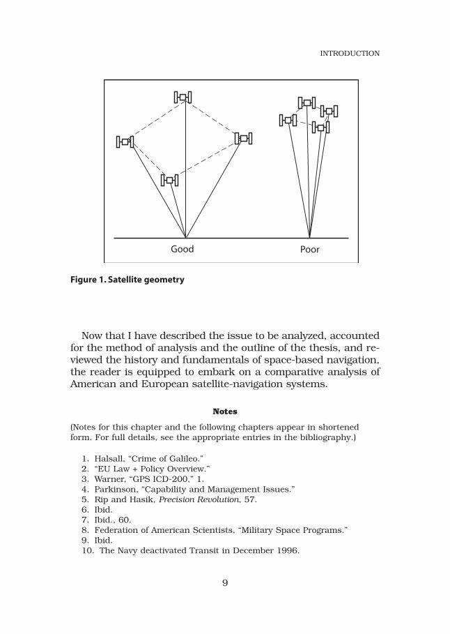
The accuracy of a user’s position fix depends on where thesatellites are in the sky with respect to the user, otherwiseknown as satellite geometry. Consider the geometry of a poly-hedron with the user at the vertex (fig. 1). The volume of thepolyhedron affects GPS accuracy. As a rule, greater satellitespacing results in a larger volume and better accuracy. Ideally,the best geometry results from having one satellite directlyoverhead and three satellites spread equally near the user’shorizon. With as many as 12 GPS satellites in view at anygiven time, the receiver must carefully select the optimumsatellite combination to obtain the best fix.15 Again, this is arelatively instantaneous and transparent function of the re-ceiver’s computer. The receiver examines all possible satellitecombinations and chooses the solution with the best satellitegeometry. The user is now in receipt of three-dimensional po-sition information accurate to within 50 feet.16
8
INTRODUCTION
Now that I have described the issue to be analyzed, accountedfor the method of analysis and the outline of the thesis, and re-viewed the history and fundamentals of space-based navigation,the reader is equipped to embark on a comparative analysis ofAmerican and European satellite-navigation systems.
Notes
(Notes for this chapter and the following chapters appear in shortenedform. For full details, see the appropriate entries in the bibliography.)
1. Halsall, “Crime of Galileo.”2. “EU Law + Policy Overview.”3. Warner, “GPS ICD-200,” 1.4. Parkinson, “Capability and Management Issues.”5. Rip and Hasik, Precision Revolution, 57.6. Ibid.7. Ibid., 60.8. Federation of American Scientists, “Military Space Programs.”9. Ibid.10. The Navy deactivated Transit in December 1996.
9
INTRODUCTION
Good Poor
Figure 1. Satellite geometry
11. Sietzen, “Galileo Takes on GPS,” 38.12. Pace et al., Global Positioning System, 239.13. Moving at the speed of light, the signal’s travel time is roughly one-
eleventh of a second.14. For a more detailed discussion of the navigation solution, see chaps.
1 and 2 of Logsdon, Navstar.15. Using a five-degree elevation mask, according to European Commis-
sion, Galileo: Mission High Level Definition, 28.16. Logsdon, Navstar, 64. The quoted accuracy refers to the Standard
Positioning Service.
10
INTRODUCTION

Chapter 2
GPS versus Galileo
GPS has become a global utility.
—Pres. Bill Clinton—1 May 2000
In this chapter I compare the two navigation systems to deter-mine critical similarities and differences and to evaluate theirstrengths and weaknesses. Specifically, I attempt to determineGPS operational deficiencies from a European perspective andthe extent to which Galileo intends to improve upon them. Theassessment begins with a review of the primary purpose andsponsorship of each system, followed by an examination of ac-tive and proposed system infrastructures, services, limitations,and vulnerabilities.
Purpose and SponsorshipThe raison d’être and sponsorship of the two navigation
systems produce two fundamentally different outlooks. Aspreviously discussed, GPS was driven by the military’s needfor increased weapon’s accuracy. Consequently, the US AirForce owned and operated the system—fully funded by the UStaxpayer—and the Department of Defense (DOD) maintainedultimate authority. Recognizing the growing use and impor-tance of GPS to the civilian community, the US governmentestablished the Interagency GPS Executive Board (IGEB) in1996. While the Air Force still operates the system, the IGEBmanages senior-level policy for GPS and is chaired jointly bythe DOD and Department of Transportation (DOT). Neverthe-less, and regardless of its dual-use potential, the primary pur-pose of GPS is “enhancing the effectiveness of US and alliedmilitary forces.”1 US national security remains the top policygoal for decisions concerning GPS.2
In contrast, Galileo came about as a direct response to theperception that GPS catered to US military requirements at the
11
expense of global civilian needs. Although the United Statespromoted GPS as a worldwide utility, it did not promote globalparticipation in managing that increasingly depended-uponglobal resource, nor would it guarantee continued access to it.Thus, Galileo emerged as a joint venture between the Euro-pean Commission (EC) and the ESA, spurred by transportministers with a decidedly nonmilitary perspective. Further-more, Galileo is funded through a public-private partnershipin which the EC and ESA provide funding in tandem with pri-vate companies participating in the project. When operational,a consortium-created private company, referred to as theGalileo Operating Company (GOC), will operate and maintainthe constellation. In short, “the US places priority on securityand allied military capability, [and] Europe places it on com-mercial viability.”3
System Infrastructure
Both the GPS and Galileo systems are subdivided into threecomponents: the space segment, comprised of the satellites;the control (or ground) segment, consisting of the commandand control infrastructure; and the user segment, encompass-ing the end user or customer.
Space Segment
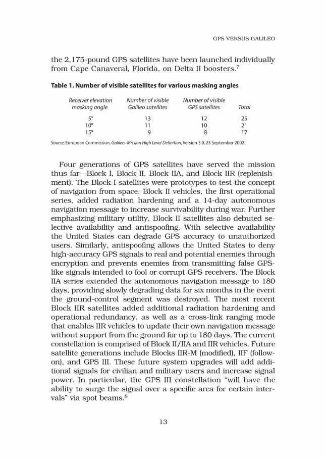
The purpose of the GPS space segment is to transmit timingpulses and satellite positional data to users worldwide. TheGPS space segment is comprised of 24 satellites in a “Walkerconstellation” at an altitude of 10,898 nautical miles (roughly20,200 km), organized in six orbital planes equally spaced inright ascension around the earth, with an inclination of 55 de-grees.4 Walker constellations (named after the British RoyalAircraft Establishment’s J. G. Walker) are satellites configuredin circular orbits with common altitudes and inclinations thatprovide global coverage of the earth.5 The design of the GPSconstellation guarantees that at least five satellites with favorablesatellite geometry (table 1) are always in view to users world-wide to meet accuracy requirements.6 Since their inception,
12
GPS VERSUS GALILEO
the 2,175-pound GPS satellites have been launched individuallyfrom Cape Canaveral, Florida, on Delta II boosters.7
Table 1. Number of visible satellites for various masking angles
Receiver elevation Number of visible Number of visiblemasking angle Galileo satellites GPS satellites Total
5° 13 12 2510° 11 10 2115° 9 8 17
Source: European Commission, Galileo–Mission High Level Definition, Version 3.0, 23 September 2002.
Four generations of GPS satellites have served the missionthus far—Block I, Block II, Block IIA, and Block IIR (replenish-ment). The Block I satellites were prototypes to test the conceptof navigation from space. Block II vehicles, the first operationalseries, added radiation hardening and a 14-day autonomousnavigation message to increase survivability during war. Furtheremphasizing military utility, Block II satellites also debuted se-lective availability and antispoofing. With selective availabilitythe United States can degrade GPS accuracy to unauthorizedusers. Similarly, antispoofing allows the United States to denyhigh-accuracy GPS signals to real and potential enemies throughencryption and prevents enemies from transmitting false GPS-like signals intended to fool or corrupt GPS receivers. The BlockIIA series extended the autonomous navigation message to 180days, providing slowly degrading data for six months in the eventthe ground-control segment was destroyed. The most recentBlock IIR satellites added additional radiation hardening andoperational redundancy, as well as a cross-link ranging modethat enables IIR vehicles to update their own navigation messagewithout support from the ground for up to 180 days. The currentconstellation is comprised of Block II/IIA and IIR vehicles. Futuresatellite generations include Blocks IIR-M (modified), IIF (follow-on), and GPS III. These future system upgrades will add addi-tional signals for civilian and military users and increase signalpower. In particular, the GPS III constellation “will have theability to surge the signal over a specific area for certain inter-vals” via spot beams.8
13
GPS VERSUS GALILEO
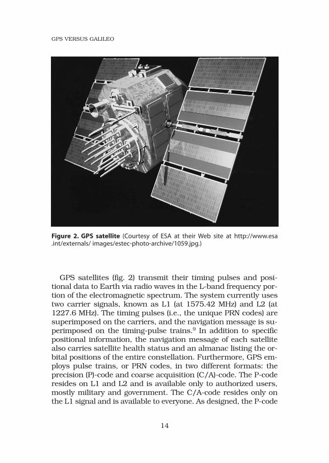
GPS satellites (fig. 2) transmit their timing pulses and posi-tional data to Earth via radio waves in the L-band frequency por-tion of the electromagnetic spectrum. The system currently usestwo carrier signals, known as L1 (at 1575.42 MHz) and L2 (at1227.6 MHz). The timing pulses (i.e., the unique PRN codes) aresuperimposed on the carriers, and the navigation message is su-perimposed on the timing-pulse trains.9 In addition to specificpositional information, the navigation message of each satellitealso carries satellite health status and an almanac listing the or-bital positions of the entire constellation. Furthermore, GPS em-ploys pulse trains, or PRN codes, in two different formats: theprecision (P)-code and coarse acquisition (C/A)-code. The P-coderesides on L1 and L2 and is available only to authorized users,mostly military and government. The C/A-code resides only onthe L1 signal and is available to everyone. As designed, the P-code
14
GPS VERSUS GALILEO
Figure 2. GPS satellite (Courtesy of ESA at their Web site at http://www.esa.int/externals/ images/estec-photo-archive/1059.jpg.)
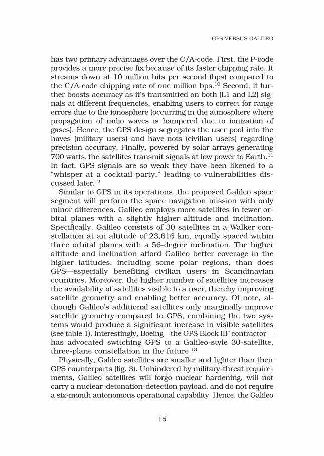
has two primary advantages over the C/A-code. First, the P-codeprovides a more precise fix because of its faster chipping rate. Itstreams down at 10 million bits per second (bps) compared tothe C/A-code chipping rate of one million bps.10 Second, it fur-ther boosts accuracy as it’s transmitted on both (L1 and L2) sig-nals at different frequencies, enabling users to correct for rangeerrors due to the ionosphere (occurring in the atmosphere wherepropagation of radio waves is hampered due to ionization ofgases). Hence, the GPS design segregates the user pool into thehaves (military users) and have-nots (civilian users) regardingprecision accuracy. Finally, powered by solar arrays generating700 watts, the satellites transmit signals at low power to Earth.11
In fact, GPS signals are so weak they have been likened to a“whisper at a cocktail party,” leading to vulnerabilities dis-cussed later.12
Similar to GPS in its operations, the proposed Galileo spacesegment will perform the space navigation mission with onlyminor differences. Galileo employs more satellites in fewer or-bital planes with a slightly higher altitude and inclination.Specifically, Galileo consists of 30 satellites in a Walker con-stellation at an altitude of 23,616 km, equally spaced withinthree orbital planes with a 56-degree inclination. The higheraltitude and inclination afford Galileo better coverage in thehigher latitudes, including some polar regions, than doesGPS—especially benefiting civilian users in Scandinaviancountries. Moreover, the higher number of satellites increasesthe availability of satellites visible to a user, thereby improvingsatellite geometry and enabling better accuracy. Of note, al-though Galileo’s additional satellites only marginally improvesatellite geometry compared to GPS, combining the two sys-tems would produce a significant increase in visible satellites(see table 1). Interestingly, Boeing—the GPS Block IIF contractor—has advocated switching GPS to a Galileo-style 30-satellite,three-plane constellation in the future.13
Physically, Galileo satellites are smaller and lighter than theirGPS counterparts (fig. 3). Unhindered by military-threat require-ments, Galileo satellites will forgo nuclear hardening, will notcarry a nuclear-detonation-detection payload, and do not requirea six-month autonomous operational capability. Hence, the Galileo
15
GPS VERSUS GALILEO
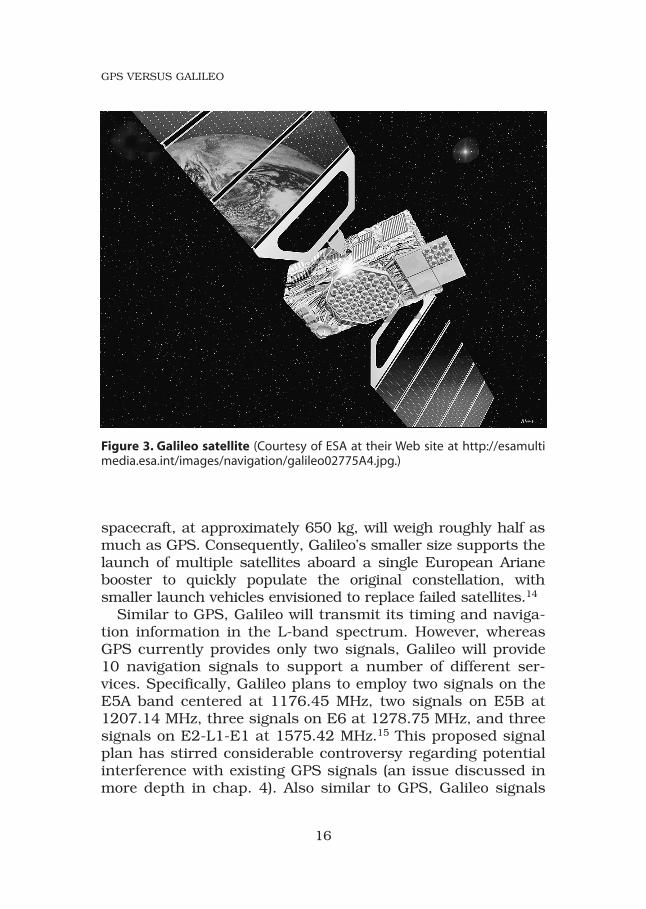
spacecraft, at approximately 650 kg, will weigh roughly half asmuch as GPS. Consequently, Galileo’s smaller size supports thelaunch of multiple satellites aboard a single European Arianebooster to quickly populate the original constellation, withsmaller launch vehicles envisioned to replace failed satellites.14
Similar to GPS, Galileo will transmit its timing and naviga-tion information in the L-band spectrum. However, whereasGPS currently provides only two signals, Galileo will provide10 navigation signals to support a number of different ser-vices. Specifically, Galileo plans to employ two signals on theE5A band centered at 1176.45 MHz, two signals on E5B at1207.14 MHz, three signals on E6 at 1278.75 MHz, and threesignals on E2-L1-E1 at 1575.42 MHz.15 This proposed signalplan has stirred considerable controversy regarding potentialinterference with existing GPS signals (an issue discussed inmore depth in chap. 4). Also similar to GPS, Galileo signals
16
GPS VERSUS GALILEO
Figure 3. Galileo satellite (Courtesy of ESA at their Web site at http://esamultimedia.esa.int/images/navigation/galileo02775A4.jpg.)
will carry different PRN code schemes that effectively segregateusers into three distinct groups: the general public, commer-cial users, and authorized government users.16 However, un-like GPS, Galileo will transmit the PRN code available to thegeneral public on two signals, enabling everyone to correct forionospheric delays and obtain higher accuracy. In essence,GPS segregates users by controlling access to better accuracy,whereas Galileo divides users by controlling access to ancillarydata. One primary type of segregated ancillary data is in-tegrity, which constitutes a major difference between GPS andGalileo. The EC defines integrity as the ability “to providetimely warnings to the user when [the system] fails to meetcertain margins of accuracy.”17 Thus, Galileo plans to con-stantly monitor system accuracy and quickly update the con-stellation upon detection of a problem.18 Specifically, Galileowill broadcast integrity flags in the navigation message with atime-to-alert of six to 10 seconds.19 Currently, GPS can takeas long as 30 minutes to notify users of an out-of-tolerancecondition.20 Galileo will be the first GNSS to incorporate real-time signal-integrity monitoring, a capability not planned forGPS until the GPS III upgrade, currently scheduled for 2012.21
Control Segment
As with the GPS and Galileo space segments, the controlsegments of the two systems are very similar. While the satel-lites of the space segments constantly transmit their locationsto the users, the satellites themselves do not know where theyare. They transmit only what they are instructed to transmit.The control segment on the ground develops, monitors, andupdates each satellite’s navigation message and then feeds thedata to the satellite for retransmission.
The US Air Force maintains and operates the GPS constel-lation via a control segment comprised of the Master ControlStation (MCS), monitoring stations, and ground antennas. TheMCS, located at Schriever AFB, serves as the central process-ing facility for GPS. Operated continuously by Air Force crewpersonnel, the MCS houses the operations center for com-mand and control of the constellation, the computers used to
17
GPS VERSUS GALILEO

predict orbits, and the array of atomic clocks that constitutesthe system’s timing reference, known as GPS time.
Linked to the MCS, five unmanned monitoring stations sup-port GPS, spread across the globe at Hawaii, Colorado Springs,Ascension Island (South Atlantic Ocean), Diego Garcia (IndianOcean), and Kwajalein (western Pacific Ocean). The monitoringstations constantly track each satellite in view, measure therange to each satellite (known as a pseudorange), and downloadeach navigation message. Then the stations send the pseudo-ranges and navigation messages to the MCS for processing.
The MCS receives the constant flow of information from themonitoring stations and calculates a fresh predicted orbit(ephemeris) for each satellite from the pseudoranges. Addi-tionally, the MCS examines the navigation message of eachsatellite to verify that the satellites are transmitting the correctones and zeroes. Finally, the MCS updates the navigationmessage for each satellite based on the new orbit predictionsand sends the resulting navigation uploads to one of fiveground antennas.
The GPS control segment employs four dedicated, unmannedground antennas located at Cape Canaveral, Diego Garcia, Kwa-jalein, and Ascension Island. A fifth antenna at Schriever AFB isalso available upon request to support GPS requirements.22 Theground antennas provide the MCS an uplink and downlink ca-pability. They receive navigation uploads and other commandsfrom the MCS and transmit them to the satellites. Moreover, theycollect and transmit telemetry, tracking, and commanding(TT&C) data, enabling the MCS to monitor and maintain the con-stellation’s health and to control each satellite. Thus, the GPScontrol segment is a data-processing loop that maintains a con-tinuous flow of accurate navigation information.
The Galileo control segment greatly resembles the GPS infra-structure. As proposed, a private business enterprise to becalled the GOC will manage the constellation from two naviga-tion system control centers (NSCC) located somewhere in Europe(possibly France and Germany, based on their sizeable contri-butions), along with a global network of unmanned orbitographyand synchronization stations (OSS) and TT&C stations.23
18
GPS VERSUS GALILEO
Like the GPS MCS, the Galileo NSCC serves as the “heart ofthe system and includes all control and processing facilities,”providing orbit determination and maintaining time synchro-nization (with Galileo time as the reference).24 As with GPSmonitoring stations, the Galileo OSS collects and measuresnavigation data and passes it to the NSCC. Finally, similar toGPS ground antennas, Galileo TT&C stations provide uplinkand downlink capabilities, linking the NSCC with the constel-lation. Despite all of these resemblances, the Galileo controlsegment is not a mirror image of its GPS counterpart.
The major difference between the control segments is Galileo’saddition of integrity monitoring. Galileo satellites are designed toprovide integrity alerts to users within the navigation signal-in-space. Thus, the Galileo control segment includes an IntegrityDetermination System comprised of integrity monitoring and up-link stations.25 The system will monitor each satellite’s signals,determine whether the signals are outside specifications, anduplink an integrity flag to the constellation identifying faultysatellites. Hence, a user’s receiver will reject the signals fromsatellites identified in the alert.26
User Segment
Since the DOD developed GPS to support national security,the US armed forces are the primary intended customer. How-ever, in 1983 after the Soviets shot down a Korean airliner thaterroneously wandered into Soviet airspace, Pres. Ronald Reagandeclared that the United States would provide civilian airlinersaccess to GPS signals, essentially establishing GPS as a dual-use system.27 Pres. Bill Clinton reiterated the US commitmentto providing civilian access free of charge in the 1996 Presi-dential Decision Directive NSTC-6.28 In contrast, Europe hasmarketed Galileo as a public GNSS geared to civilian and com-mercial user requirements and has downplayed Galileo’s mili-tary utility. Generally speaking, nonmilitary customers com-prise the overwhelming majority of all GNSS users; however,GPS places the military user above the civilian for reasons ofnational security.
19
GPS VERSUS GALILEO
Services
GPS provides position, navigation, and timing (PNT) serviceswith two different levels of accuracy: the Standard PositioningService (SPS) and the Precise Positioning Service (PPS). The un-encrypted SPS offers PNT services free of charge to all users.Based on the less accurate C/A-code transmitted on L1, theSPS cannot self-correct for ionospheric errors and so producesless accurate navigation solutions than the PPS. Additionally,to prevent adversary use of GPS against US forces duringconflicts, the US government can intentionally degrade SPSaccuracy via selective availability. For many years, selectiveavailability fixed SPS accuracy at roughly 100 meters. How-ever, in 2000 President Clinton directed that the DOD turn offselective availability; consequently, SPS accuracy increasedtenfold to roughly within 10–20 meters.29 While the SPS is un-encrypted, the United States currently encrypts the PPS andrestricts access to authorized users, mainly the armed forcesand government agencies. Based on the P-code transmitted onL1 and L2, the PPS offers more accurate PNT services with po-sitional accuracy of approximately 25 feet.30
In contrast to GPS, Galileo plans to offer five types of ser-vices—Open Service (OS), Commercial Service (CS), Safety-of-Life (SoL) Service, Public Regulated Service (PRS), and Searchand Rescue (SAR) Support Service.
Open Service
OS is similar to the GPS SPS in that it is intended for the gen-eral public and is provided for free. However, since OS will betransmitted on two frequencies, users of this basic service cancorrect for ionospheric effects and obtain better accuracy thanwith the GPS SPS. Specifically, the ESA expects to achieve four-meter accuracy with a service availability of 99.8 percent.31 GPSwill not provide this level of accuracy until the Block IIF con-stellation is operational circa 2012.32 Again, similar to the GPSSPS, the OS provides no service guarantee or integrity informa-tion to the general public. Like the GPS’s civilian users, Galileo’sOS customers use Galileo at their own risk.
20
GPS VERSUS GALILEO
Commercial Service
CS is a combination of OS plus two encrypted signals sepa-rated in frequency from OS signals.33 Like OS, CS will not ex-plicitly carry integrity data; however, CS accuracies will beguaranteed. Designed to support users requiring higher per-formance than OS, CS’s additional signals allow the develop-ment of professional applications such as producing high-data-rate broadcasting, resolving ambiguities in differentialapplications, and integrating Galileo with wireless communi-cations.34 Access to the encrypted signals will be restricted tofee-paying users who will subscribe to CS. Third-party serviceproviders will determine the specific services offered and willpurchase the rights to utilize the encrypted signals via a licenseagreement with the GOC.35 Finally, the company will providea guarantee for disruption or degradation of service and willprovide timely warning to users. Failure to meet standardswould lead to compensation to affected users and/or serviceproviders. Service guarantees addressing liability constitute amajor difference between Galileo and GPS.
Safety-of-Life Service
SoL will offer the same accuracies as OS, but it will provideboth integrity data and service guarantees for a fee. SoL is de-signed to serve safety-critical users who require precision ac-curacy and signal reliability. Anticipated customers includeairlines, trains, and transoceanic maritime companies.36 WithSoL, Galileo plans to comply with “levels of service stipulatedby law in various international transportation fields,” such asthose prescribed by the International Civil Aviation Organiza-tion.37 SoL’s integrity monitoring is essential to meeting thisgoal. Galileo will reportedly inform users of out-of-toleranceconditions within six to 10 seconds of occurrence, supportingsafety-critical applications such as Category I landings (air-craft landings with weather conditions of a 200-foot ceilingand visibility of one-half mile). However, this additional servicecomes at a price. Users will need specialized receivers to getthe enhanced signals,38 and the EC retains the option to en-crypt integrity data and administer access fees.39
21
GPS VERSUS GALILEO
Public Regulated Service
The objective of PRS, according to the EC and ESA, “is to im-prove the probability of continuous availability of the SIS [signal-in-space], in [the] presence of interfering threats.”40 Envisionedas a protected navigation service for government and public-service users, PRS will employ robust signals with interferencemitigation technologies to reduce susceptibility to jammingand interference from terrorists, criminals, or hostile entitiesthat could affect national security.41 Furthermore, PRS must re-main operational during crises, when other services may bejammed. Hence, Galileo transmits PRS on two wideband signals(to increase jamming resistance) and spectrally separates themfrom other Galileo services, so these other services “can be de-nied without affecting PRS operations.”42 Additionally, PRS willbe encrypted to restrict access to interference-mitigation tech-nologies and to prevent hostile use of PRS against EC memberstates (in this paper, the word states used in context with Europerefers to EU nation-states).43 Accordingly, EC member states willcontrol PRS access via cryptological keying systems. Based onthis description, the Galileo PRS sounds very similar to GPS PPSand presents a potential military capability in a system strictlytrumpeted as “the first satellite . . . navigation system specificallyfor civil purposes.”44 In fact, while Galileo is frequently touted as“a civil system, operated under public control” and “a non-mili-tary programme,” the design and spectral locations of PRS sig-nals mirror future GPS military upgrades, potentially conflictingwith US navigation warfare (NAVWAR) concepts (see chap. 4).45
Search and Rescue Support Service
SAR will augment the Cospas-Sarsat system, which assistsinternational search and rescue efforts by detecting and locat-ing distress signals worldwide. Galileo satellites will employSAR transponders that will detect distress alerts and relay thedetection to Cospas-Sarsat ground stations. Moreover, Galileowill also send an acknowledgement to the stranded personsinforming them they have been located. Consequently, Galileowill reportedly fine-tune alert-location accuracy, greatly im-proving the current specification of five kilometers.46 Also,
22
GPS VERSUS GALILEO
Galileo will provide near-real-time reception of distress mes-sages, greatly reducing the current wait time of one hour.47
In short, both GPS and Galileo provide basic PNT servicesopen to all users, as well as augmented services restricted toauthorized users. However, Galileo plans to offer additionalfeatures such as service guarantees, global-integrity monitor-ing, and additional data services supporting commercial mar-kets in an attempt to capitalize on GPS limitations from a civil-ian perspective.
Limitations and VulnerabilitiesIn general, the performance of GPS and the impact of its PNT
capabilities have led to its perception as a global utility.48 How-ever, like every system, GPS has limitations and vulnerabilities.While the proposed Galileo design will purportedly overcome sev-eral GPS deficiencies, including liability, integrity, and inade-quate civilian accuracy, other issues affect both systems. Theseinclude “urban canyons” (often occurs in cities, created by tallstructures obscuring signals), susceptibility to jamming, andhostile use by potential adversaries.
One of the primary differences between GPS and Galileo isthe latter’s liability service guarantee. Unlike GPS, Galileoplans to provide a guarantee against disruption of service interms of accuracy, continuity of availability, and integrity,where interruptions “would have significant [safety] or eco-nomic impacts.”49 This translates to a service guarantee forGalileo’s CS and SoL service. Thus, Galileo will provide a legalframework to increase the confidence of users previously re-luctant to utilize space-based radio navigation signals as a pri-mary means of navigation. As mentioned before, the GOC (theprivate company chosen to manage the constellation) will com-mit to providing the signal quality required to support thespecified services and will compensate users if signal qualityfalls short of specifications without adequate warning.50 Inthis manner, Galileo users sidestep the potential barriersfaced by GPS users who file claims against the US governmentas GPS owners—GPS does not provide a service guarantee.
On the surface, a service guarantee appears marginal or in-significant—the general public will largely ignore it. However,
23
GPS VERSUS GALILEO
a significant subset of users (such as air traffic controllers)would highly value service guarantees for safety-critical orprecision operations. The functions these users provide, pri-marily accomplished through national governments employingGalileo and GPS as the basis of their transport policies, do af-fect entire populations. The lack of a service guarantee couldimpede GPS’s ability to compete in this critical niche. As a sen-ior fellow on the Council on Foreign Relations observed, “UntilGPS is certifiable for aviation use worldwide, its usefulnesswill be unavoidably curtailed.”51
The viability of Galileo’s service guarantee remains to be seen.Its credibility depends on the system’s ability to compensate auser’s loss, leading to a multitude of contractual and liability is-sues beyond the scope of this study. In short, the EU foreseesthe guarantee relying on legal mechanisms “to prevent, inform,alert, or compensate failure, disruption, or provision of a ser-vice” due to failing specifications.52 These may include certifica-tion of risks, licensing usage, and mechanisms to manage com-pensation or reimbursement and jurisdiction/recourse issues,yet to be defined.53 The crux of Galileo’s service guarantee is ad-equate warning of substandard performance, accomplished viaintegrity monitoring.
Lack of real-time integrity monitoring is another shortcomingof GPS from the civilian perspective. Currently, if a GPS satellite’snavigation signal drifts out of tolerance, the GPS control segmentmust schedule a contingency contact to refresh the satellite’smemory with a new navigation upload or set the satellite’s healthflag within the navigation message. Depending on satellite visi-bility, this process could take up to 30 minutes before the satel-lite transmits corrected information.54 Meanwhile, users are notwarned of the out-of-tolerance condition and could continue touse less accurate data.55 In contrast, Galileo plans to directlywarn users of substandard performance in less than 10 seconds,allowing customers “of standard commercial services to reactrapidly to malfunctions,”56 albeit potentially for a fee. Similar tothe reaction to Galileo’s service guarantee, one might concludethat integrity for a price would appeal only to a small number ofprofessional users, certainly not the majority of recreationalGNSS users. Although integrity could be characterized as a
24
GPS VERSUS GALILEO

niche service, many users who prefer integrity provide servicesthat affect the mass public, such as the airline, banking,telecommunications, and transport industries. Therefore, whileintegrity may directly serve the needs of only a few niche users,integrity indirectly affects virtually everyone. Consequently,Galileo bests GPS by offering fee-based integrity. However, withrespect to free/open services, neither GPS nor Galileo providesreal-time integrity monitoring, though Galileo’s free services willreportedly be more accurate.
A third shortcoming of GPS is its level of accuracy afforded tocivilian users. This deficiency is in part a deliberate characteris-tic of the system. Designed as a national-security asset, GPS pro-vides better accuracy for military users. Selective availabilityintentionally decreased civilian accuracy in the past, but evenwithout selective availability, civilian accuracy is inherently lessprecise than Galileo’s because the SPS is transmitted on onlyone signal. In contrast, the military utilizes two frequencies inorder to improve accuracy by correcting for ionospheric errors.Galileo plans to transmit its free OS on dual frequencies,enabling higher accuracies for civilians than is currentlypossible with GPS.57 In addition to dual-frequency use, the GPSconstellation design causes accuracy to degrade at higher lati-tudes. Accuracy degrades because satellite geometry (as definedin chap. 1) diminishes at higher latitudes. At latitudes above 55degrees, GPS satellite spacing becomes increasingly confined tothe user’s horizon, with no satellites directly overhead. Thus,poor satellite geometry results in lower overall accuracy. Conse-quently, Galileo hopes to improve satellite geometry at higherlatitudes by orbiting satellites in higher inclinations and alti-tudes than those offered by GPS, thereby providing users withsatellites higher on their horizon (although not directly overhead).
Lower accuracy at higher latitudes is one of the orbit-limitingcharacteristics of GPS. Accuracy also suffers in cities andother areas of severe occultation where signals are prohibitedfrom reaching the user. In fact, such urban canyons can limitservice availability to 55 percent of a typical city’s territory.58
While Galileo will also endure the same coverage problemson its own, the combination of 29 GPS and 30 Galileo satel-
25
GPS VERSUS GALILEO

lites could improve positioning-service coverage to 95 percentof an urban area.59
In addition to signal blocking by natural and man-madebarriers, jamming can also affect signal availability by denyingservice to local areas. By design, GPS signals reach the userat very low power levels of only a few milliwatts.60 With such aweak signal, even low-watt jammers can be effective. Less thanone watt of power will suffice to jam standard receivers at arange of 25 kilometers, while a 100-watt jammer “can blanketa 65-kilometer region.”61 To put this into contemporary per-spective, “a single electronic jammer radiating at one-tenth ofa watt could prevent [civilian receivers] from tracking GPS withinthe Baghdad metropolitan area.”62 In a real-world example, ata tank competition in August 2000 sponsored by the Greekgovernment, a French security agency jammed British and UStanks during trial demonstrations, causing significant navi-gation problems.63 Although Galileo plans to transmit at aslightly higher power, it too will be susceptible to intentionaland possibly inadvertent jamming. Various techniques areavailable to reduce this susceptibility, but susceptibility tojamming is not altogether a bad thing because it enables theUnited States to deny locally the use of GPS to potentially hos-tile individuals, parties, etc.64
GPS and Galileo are mutually susceptible to hostile use byan enemy or adversary. Since both systems offer free and openservices to anyone with a receiver, significantly increased ac-curacy is available to rogue states, terrorists, and rising peercompetitors like China. Originally, selective availability servedto deprive hostile users of precise GPS PNT services, but it alsodeprived legitimate civilian users, who outnumber military users100 to one.65 For this reason, the United States terminated thecapability in 2000. Likewise, Galileo currently has no methodof denying its OS to undesirable users (other than jamming).As a result, many states, including EU members and those inthe so-called axis of evil, have enhanced their military capa-bilities via GPS.66 North Korea has reportedly utilized GPS onits submarines, China is integrating it into fighter aircraft, andIran Aircraft Manufacturing plans to incorporate GPS onboard new variants of its Ababil unmanned air vehicle.67
26
GPS VERSUS GALILEO
This chapter has examined GPS and Galileo for similaritiesand differences to determine if GPS had deficiencies thatGalileo could exploit and, ultimately, to forecast if Galileocould provide a better source for navigation than GPS. Al-though the two systems were founded on fundamentally dif-ferent visions, the similarities outnumber the differences. GPSis designed to support national security, while Galileo is de-signed to make Euros. Nevertheless, the two systems sharesimilar infrastructures, performing virtually the same func-tions to provide like PNT services.
While GPS has arguably become a global public utility, thesystem is not without significant limitations and vulnerabilities.Galileo claims it will resolve several GPS deficiencies, includ-ing liability, integrity, and inadequate civilian accuracy. Evenif these assertions prove true, GPS modernization programs(see subsequent chapters) will eventually level the playing fieldonce again. Moreover, GPS and Galileo are mutually deficientand vulnerable regarding urban canyons, jamming, and hos-tile use by potential adversaries.
Assuming Europe fields Galileo as claimed, Galileo will out-perform GPS in the near term from a civilian perspective byproviding a guaranteed service with better accuracy andglobal-integrity monitoring—for a price. However, in the not-too-distant future the United States will upgrade GPS, enabling itto provide the same services to the same users for free. Giventhis inevitable outcome, it remains uncertain why Europeanswould expend the enormous capital involved to compete witha successful and reliable system not only backed by the USgovernment but also available free of charge.
Notes
1. United States Mission to the European Union, “US Global PositioningSystem.”
2. Ibid.3. Julie Karner (assistant director, Office of Space and Advanced Tech-
nology, US Department of State), interview by the author, 5 Jan. 2004.4. As of 14 Jan. 2004, GPS had 29 operational satellites in orbit. Maj
Michael Brownworth, GPS Operations flight commander, interview by theauthor, 13 Jan. 2004.
5. Wertz and Larson, Space Mission Analysis and Design, 175.
27
GPS VERSUS GALILEO
6. Pace et al., Global Positioning System, 218.7. The weight listed is the on-orbit weight of Block II satellites. Block IIR
satellites weigh 2,370 pounds, and Block IIF satellites will weigh 3,407 pounds.8. Sirak, “Holding the Higher Ground,” 21.9. Logsdon, Navstar, 20–21.10. Ibid., 20.11. The power listed is for Block II satellites. Block IIR satellites generate
1,136 watts, and IIF will generate 2,900 watts.12. Divis, “This Is War.”13. Richardson, “GPS in the Shadows of Navwar,” 26.14. Benedicto et al., “Galileo: Satellite System,” 9.15. European Commission, Galileo: Mission High Level Definition, 41–42.16. Ibid., 29.17. Ibid., 16.18. Galileo will provide integrity monitoring independent of augmenta-
tion systems like the European Geostationary Navigation Overlay Service(EGNOS). Also, Galileo will provide global-integrity monitoring, whereasEGNOS is a regional system serving greater Europe.
19. Benedicto et al., “Galileo: Satellite System,” 13.20. Brownworth, interview.21. Pappas, “Effects of the Galileo,” 8.22. Unlike the dedicated antennas, the antenna at Schriever AFB (known
as PIKE) is part of the Air Force Satellite Control Network (AFSCN) and sup-ports many satellite programs in addition to GPS.
23. Benedicto et al., “Galileo: Satellite System,” 1. The NSCC, OSS, andTT&C are also known as the Galileo Control Center, Galileo Sensor Station,and Galileo Uplink Station, respectively.
24. European Commission, Galileo: Mission High Level Definition, 30.25. Current documentation implies separate equipment for integrity
functions vice assigning the mission to OSS and TT&C stations.26. Benedicto et al., “Galileo: Satellite System,” 13.27. Statement by the principal deputy press secretary to the president,
16 Sept. 1983, in Rip and Hasik, Precision Revolution, 429.28. Presidential Decision Directive NSTC-6, US Global Positioning System
Policy.29. US Department of State, “US Global Positioning.”30. Logsdon, Navstar, 64.31. European Commission, Galileo: Mission High Level Definition, 14.32. Parkinson, “Capability and Management Issues.”33. Ibid., 15.34. Wilson, Galileo: The European Programme, 20.35. European Commission, Galileo: Mission High Level Definition, 15.36. Wilson, Galileo: The European Programme, 20.37. Galileo: Mission High Level Definition, 16.38. Commission of the European Communities, Commission Communi-
cation to the European Parliament, 13.
28
GPS VERSUS GALILEO
39. Karner, interview.40. European Commission, Galileo: Mission High Level Definition, 17.41. Ibid.42. Wilson, Galileo: The European Programme, 21.43. The European Commission (EC) contains the executive function of
the European Union (EU). The EU, which currently has 25 member “states”or nations, works towards and oversees the economic and political integra-tion of these states.
44. Wilson, Galileo: The European Programme, 5.45. European Commission, Galileo: Mission High Level Definition, 6; and
European Parliament, Report on the Commission Communication to the Euro-pean Parliament, 40.
46. European Commission, Galileo: Mission High Level Definition, 19.47. Ibid.48. Adams, “GPS Vulnerabilities,” 11.49. European Commission, European Dependence, sec. 3; and European
Commission, Galileo: Mission High Level Definition, 11.50. European Commission, European Dependence, 12.51. Braunschvig et al., “Space Diplomacy,” 159.52. European Commission, European Dependence, 24.53. Ibid.54. Brownworth, interview.55. Augmentation systems like the Wide Area Augmentation System
(WAAS) provide localized or regional GPS integrity information to civilianusers, but these systems operate independently of GPS. Galileo allegedly willinherently provide global integrity coverage.
56. European Commission, European Dependence, sec. 3.57. Future GPS upgrades will provide additional signals for civilian
users, but Galileo will provide this service first.58. European Parliament, Report on the Commission Communication to
the European Parliament, 28.59. Ibid.60. A milliwatt is approximately -160 dBW (power level in decibels rela-
tive to one watt). Alterman, “GPS Dependence,” 54.61. Rip and Hasik, Precision Revolution, 278; and Richardson, “GPS in
the Shadows of Navwar,” 22.62. Rip and Hasik, Precision Revolution, 280.63. Adams, “GPS Vulnerabilities,” 12.64. Jam-resistance techniques have fortified military receivers such that
a 100-watt jammer would need to be within 0.3 nautical miles to cause sig-nificant problems. Roos, “Pair of Achilles Heels,” 22.
65. GPS Joint Program Office, “Navstar GPS Fact Sheet.”66. Iraq, Iran, and North Korea were termed axis of evil nation-states in
Pres. George W. Bush’s State of the Union Address on 29 Jan. 2002.67. Snyder, “Navigating the Pacific Rim”; and Adams, “GPS Vulnerabili-
ties,” 11. China is not exactly an axis of evil state, per se.
29
GPS VERSUS GALILEO
Chapter 3
Why Galileo?
If you use your parent’s car, there will come a day when it’snot available.
—Gilles Gantelet—European Commission Spokesman
In 1996 the US government pledged to provide GPS “for peace-ful civil, commercial and scientific use on a continuous world-wide basis, free of direct user fees,” and it has largely kept itsword.1 Since its operational inception in 1994, GPS remainsomnipresent and complementary. However, Europe, America’straditional ally for the past six decades, has decided to expend 3.6billion euros to pursue its own satellite-navigation system. Whywould anyone pay to build a capability that is already availablefor free? Only the Soviet Union, America’s Cold War enemy, sawfit to build a Global Navigation Satellite System (GLONASS) pri-marily to guide its bombers and missiles against America and itsallies.2 Europe harbors no such plans, so why Galileo?
In this chapter, I examine Europe’s rationale to build a sepa-rate satellite-navigation system. I contend there are three mainsources of motivation propelling Europe towards Galileo: im-proved performance, independence from the United States, andeconomic opportunity.
Performance
Many Europeans believe that “consumer reliance on satel-lite navigation will turn into dependence, as [its] use becomesan essential tool for business and daily lives.”3 They are fur-ther concerned that as business expands and reliance in-creases, GPS may not be upgraded to meet future needs in atimely fashion. Hence, GPS performance in the form of accu-racy, reliability, and vulnerability has become a primary con-cern and motive for European development of Galileo.
31
Originally, the United States designed GPS as a militarysupport system and intentionally degraded civilian-accessibleaccuracy through selective availability to approximately 100meters. This policy continued until President Clinton terminatedit in May 2000. However, as the Europeans quickly point out,the United States still maintains the capability to degrade civil-ian GPS accuracy immediately upon direction.4 Thus, manyEuropeans fear (or claim to fear) that the “military character ofGPS means there is always a risk of civil users being cut off inthe event of a crisis.”5 Although technically possible, such anoccurrence is remote because the United States has never de-graded (beyond established selective-availability policy levels)or removed GPS signals during wars or crises. For instance,the United States neither increased degradation beyond thestandard 100 meters during operations in Bosnia and Kosovonor reactivated selective availability during post-9/11 operationsin Afghanistan and Iraq.6 Nevertheless, even with selectiveavailability turned off, GPS accuracy does not meet require-ments for all civil applications.
Although GPS civilian accuracy suffices for recreational andmany other functions, accuracy of 10–20 meters provided bya single signal does not meet requirements for sole-meansnavigation in safety-critical applications such as entering aseaport or landing aircraft under poor weather conditions.7
Moreover, “current space-based radio navigation systems donot provide adequate performance to meet European multi-modal and multi-sector needs.”8 For that, Europe’s use of GPSwould require heavy investments in differential technology inwhich line-of-sight limitations constrain use to localized areas(without additional investments in Wide Area AugmentationSystems [WAAS]).9 Alternatively, the proposed Galileo systemwill transmit multiple civilian signals, providing a global accu-racy of approximately four meters.10 Additionally (as discussedin chap. 2), GPS accuracy degrades at high latitudes and inurban settings. The Center for Transport Studies at ImperialCollege, London, tested the urban-canyon problem in the Eng-lish capital and discovered that GPS five-meter accuracy wasavailable only 17 percent of the time.11 Galileo’s orbit designhopes to improve accuracy for Nordic users, but it is unlikely
32
WHY GALILEO?

to overcome the urban-canyon occultation problem on its own.The largest improvement in accuracy for any environmentwould come not from a new system, but from the combinationof GPS and Galileo systems. More satellites in orbit will in-crease the “probability of having a clear view to sufficientsatellites for a robust positioning solution.”12 However, while“mediocre and varying position accuracy” is an issue, Euro-peans are more concerned with the availability and reliabilityof GPS signals.13
The GPS civilian service, the SPS, is not guaranteed world-wide at all times. In fact, it is not guaranteed at all. Nor does itquickly inform users of substandard performance. While GPS isgenerally reliable and system failures are rare, outages havecaused discontinuous service in the past. In 2000, for example,GPS satellite malfunctions deprived the areas of Oklahoma,Kansas, and Nebraska of navigation signals for 18 minutes.14 Inother cases, a Canadian research body reported that one air-craft was affected by an unannounced signal interruptiongreater than 80 minutes, and Icelandic aviation authoritiesnoted that several transatlantic flights in their control zone weresimilarly disturbed.15 Likewise, the deactivation of a satellite formaintenance shut down a series of automated bank-teller ma-chines as well as a communications network that relied on GPSfor synchronization.16
Consequently, if satellite navigation is a keystone of trans-portation infrastructure, even minor service discontinuitiescan have severe consequences for safety. For this reason theEuropean transport industry is a primary driving force behindGalileo.17 Not surprisingly, Europeans have identified satellitenavigation as an essential tool for implementing the EuropeanTransport Policy.18 Extant terrestrial navigation aids varywidely in number and technology across Europe, and eachtransport community uses different types of systems withouta coordinated policy at the European level.19 Europe plans toemploy a GNSS to standardize and “harmonize future trans-port guidance systems.”20 Numerous safety-critical applica-tions will depend on the GNSS. Accordingly, EU directives forsafe transport of people and goods require a GNSS to provideservice guarantees with liability commitments.21 Given that
33
WHY GALILEO?

GPS does not provide such guarantees, Europe is seeking aseparate GNSS.
The last European concern regarding GPS performance is vul-nerability. As confirmed in the US DOT’s Volpe Report, GPS issusceptible to intentional (jamming) and unintentional inter-ference. As previously noted, GPS is easily jammed because itemploys extremely low-power signals. For the same reason it isalso susceptible to unintentional disruption from mobile-phonesatellite systems, television broadcasts, and natural phenomenasuch as ionospheric interference and solar flares.22 This situa-tion was illustrated when interference affecting GPS receiversand differential stations in and around the harbor of Monterey,California, was traced to a fishing boat and two other sourcesusing active television antennas emitting in the L1 frequencyrange.23 In view of these vulnerabilities, the Volpe Report statesthat GPS cannot serve as a sole source of PNT services forcritical applications and that backup systems are vital for allGPS applications involving the potential for major economic orenvironmental impacts or SoL situations.24
The United States has not sat idle in the face of these per-formance drawbacks. The ongoing GPS modernization plan willeventually address all of these shortcomings. Next-generationsatellites—the Block IIR-M—will add a second civilian signalon L2 (referred to as L2C), greatly increasing civilian accuracy.Block IIR-M will also debut the military M-code on L1 and L2,“which will provide improved signal-processing techniques forenhanced jamming resistance.”25 Block IIF satellites will add athird civilian signal, L5, featuring more power and a new cod-ing scheme. The signal will increase availability and civilianaccuracy, potentially to the centimeter level.26 The United Statesplans to begin launching Block IIF satellites in 2006.27 GPS IIIsatellites will have 100 to 300 times the transmission power ofthe current constellation to mitigate jamming and interfer-ence.28 They will also debut high-gain antennas to generate di-rectional spot beams several hundred kilometers in diameter.29
Spot beams will allow the US military to focus more power inparticular regions to resist jamming.30 Lastly and perhapsmost importantly, GPS III will provide integrity monitoring, in-creasing reliability by quickly informing users of performance
34
WHY GALILEO?

degradation.31 Unfortunately, GPS III will not begin launchinguntil 2012.32 In due course, GPS will address all these statedperformance concerns regarding accuracy, reliability, and vul-nerability. However, Europe and the rest of the world will notwait—they plan to act independently.
IndependenceAn increasingly integrated Europe has progressively sought
to “acquire power and project geopolitical ambition,” especiallysince the end of the Cold War.33 One of the EU’s chief goals isto create “a superpower on the European continent thatstands equal to the United States.”34 Naturally, this ambitionextends to space. As early as 1991, the EC hinted at the po-tential development of an independent navigation system toreduce European dependence on US space-defense systems.35
Unsurprisingly, the ESA claims that “European independenceis the chief reason” for building Galileo.36 Indeed, Galileostrengthens Europe’s bid for political, security, and techno-logical independence from the United States.
Political Independence
Originally, Europe did not plan to build its own satellite-navigation system. It had hoped to participate in an interna-tionally developed global system similar to GPS for civilian use“under the aegis of the United Nations.”37 However, the UnitedStates concluded that this idea was not in its best interest. Itwould not cede control of GPS and was not interested in run-ning an additional system, effectively stalling the developmentof a global system under civilian control and, ultimately, plant-ing the seeds for Galileo.38 In the meantime, GPS flourished.
To the extent that it affects sovereignty, the impact of GPSon modern European society is pervasive. Europe plans to em-ploy a GNSS to aid the implementation of a broad set of poli-cies that includes regulating agriculture, fisheries, and trans-portation services.39 For example, Europeans forecast highgrowth rates for inland transport that will double loading by2020.40 This increase is expected to overwhelm the existing in-frastructure.41 The European GNSS is expected to provide a
35
WHY GALILEO?
sustainable transport policy by monitoring traffic flows, pre-venting congestion, and enabling automatic toll paymentswithout stopping for tollgates.42 Thus, GNSS technology willbecome increasingly embedded in European domestic policy,forming “the basis of important commercial applications andgovernment-supported infrastructures.”43 In the absence ofGalileo, these basic governmental decisions and policies woulddepend upon US policy for GPS, which is subject to changewithout reference to European requirements. Without Galileo,European critical infrastructure will rely on a system ownedand operated by a foreign power’s military. This potential con-dition conjures up fearful images that “Europe can be held toransom on all issues related to its use of GPS and might beobliged to pay governmental levies to the US in the future.”44
Additionally, under various international conventions, EUmember states have public obligations to provide safe naviga-tion and certain other public services, such as SAR.45 TheseEuropean states have laws requiring them to control and regu-late navigation aids used in SoL applications, but Europe can-not control or regulate GPS.46 Ultimately, the European Par-liament (EP) concluded that “the sovereignty and safety ofEurope will be in serious danger if the European navigationsystems are removed from European control.”47
In addition to sovereignty, a powerful political motive spurringthe pursuit of Galileo is prestige, influencing the development ofpolicies that allocate status and acknowledge achievement.48 In1957 the launch of Sputnik instigated an international spacerace—essentially a superiority contest between the United Statesand USSR to garner influence over the rest of the world. Manybelieved that “emerging Third World nations would follow thecountry considered most technically advanced, for developmentand political reasons.”49 However, “since the end of the Cold War,the stakes in the space race have shifted from prestige . . . to-wards market shares and dominance for applications.”50 Todayspace activities are judged by what they provide to society in thebroad sense, especially economically.51
Nonetheless, Europeans still regard space as an area for sig-nificant technological innovation that can elevate internationalstanding.52 Similar to the impacts of Ariane and Airbus, Euro-
36
WHY GALILEO?

peans believe Galileo will enhance the international influence ofthe EU.53 Galileo will help build leading-edge technology and astrong economy, prime assets regarding Europe’s influence andattractiveness in the world.54 According to an EU governmentadvisor, “There was a prestige aspect involved in the whole de-velopment [of Galileo], that Europe wanted to show that theycould indeed do something.”55 Epitomizing the influence ofvying for status, French president Jacques Chirac warned thatEurope’s failure to develop Galileo “would inevitably lead to [Eu-rope] becoming . . . vassals” of the United States.56
Additionally, anti-American sentiment on the part of Europeanelites may be augmenting the pursuit of Galileo.57 Inflamed byAmerica’s unilateralist expansion of the war against terrorism toIraq and the explicitly preemptive rhetoric contained in the 2002National Security Strategy of the United States, some Europeanleaders have grown disgruntled “with America’s might and itsoverbearing ways.”58 Consequently, Europe may symbolicallyview Galileo as “a means to struggle against American hege-mony.”59 Regardless of the political motive, would the UnitedStates place its policies for national security and economic de-velopment on critical infrastructure owned by Europe?
Security Independence
The European security perspective has changed over theyears, and Galileo will play an important role in the future de-fense of Europe. Europe has depended on the United Statesfor security since the end of World War II. NATO was designedto keep the “Americans in, the Russians out, and the Germansdown.”60 However, the end of the Cold War changed the geo-political landscape. In Europe today, the Americans are super-fluous, the Russians are irrelevant, and the Germans are inte-grated. European security has faded as an American priorityin the absence of the USSR, as illustrated both by Congress’sinsistence that Europe bear a greater defense burden and byAmerica’s reluctance to prosecute the war in Kosovo.61 Cer-tainly, the post-9/11 environment refocused American priori-ties on homeland defense and the war on terrorism.
While originally slow to respond to these changes, Europehas redoubled its efforts to build a common defense policy in
37
WHY GALILEO?
the wake of the Kosovo campaign, an indication that “the Euro-peans are scared . . . that America will not show up the nexttime war breaks out somewhere near Europe’s periphery.”62
Indeed, by 2000 the EU established the position of High Repre-sentative for Common Foreign and Security Policy and commit-ted itself to fielding a rapid-reaction force of 60,000 troops de-ployable for at least a year to conduct peace operations.63 Afterthe Kosovo war, “several European governments agreed thatan autonomous satellite navigation capability must serve as thebasis for Europe’s security and defense policy.”64 Thus, Europeis taking steps to end its security dependence, and Galileo willfigure prominently in the endeavor. However, supporting militaryoperations goes against a founding principle of Galileo.
Europe insists Galileo is designed “specifically for civilian pur-poses,” as compared to GPS, which was “designed during theCold War for military purposes.”65 By contrasting Galileo’s peace-ful orientation with GPS’s military roots Europe implies thatGalileo is the best choice for civilians, since meeting civilianneeds is not the Pentagon’s top priority.66 The European Parlia-ment expressly stated that “[Galileo] is being developed by civil-ian organizations . . . and run under civilian control. . . . [Galileo]is not designed for specifically military purposes.”67 Some EUstates were quite emphatic that Galileo remain strictly civilian innature.68 In particular, the British insisted that all public state-ments about Galileo stress civilian applications.69 Moreover, theydid not see the need for the PRS, Galileo’s encrypted service withpotential military value.70 Essentially, the Galileo doves felt that“using Galileo for military purposes would jeopardize businessinvestments.”71 In contrast, France has quietly championedGalileo for military purposes and has previously threatened towithdraw support for it without the PRS.72 Historically, Franceled European efforts for autonomy, marked by its independentprocurement of nuclear weapons in the face of American non-proliferation policy, its departure from NATO’s military commandstructure, and its push for the Airbus and Ariane programs. Infact, France believed that “Europe as a whole was destined toeventually move away from military, economic, and techno-logical dependence on the US.”73 As the giant of the Europeanspace industry, France used its influence to help move the EU’s
38
WHY GALILEO?
position on Galileo from a civil system under civil control, to acivil system usable by the military, to a system critical for Euro-pean defense.74 In the end, the Directorate-General for Energyand Transport (DG-TREN) acknowledged, “Although designedprimarily for civilian applications, Galileo will also give the EU amilitary capability.”75
GNSS technology has proven essential to military capabili-ties, as illustrated by the impact of GPS on US military opera-tions. During Operation Desert Storm, GPS guided coalitionforces through the featureless desert, from the tanks involvedin the famous left-hook maneuver to the Apache and Pave Lowhelicopters that provided the opening salvos of the war.76 Dur-ing Operation Allied Force (OAF), GPS-guided munitions be-came a requirement, enabling precision all-weather bombingof Kosovo and Belgrade.77 Without GPS, pilots facing 50 per-cent cloud cover more than 70 percent of the time would haveto wait for clearer skies, creating sanctuaries and operationallulls.78 GPS-guided munitions proved so effective that US re-liance on them increased from 3 percent of all bombs duringOAF to roughly 60 percent in Operation Iraqi Freedom (OIF).79
In addition to precision navigation and munitions, GPS alsoprovided enhanced battlefield awareness. During OIF the USArmy and special operations forces utilized Blue Force Track-ing (BFT) systems that integrated GPS with other space technol-ogy to provide theaterwide situational awareness. BFT signifi-cantly reduced fratricide in OIF, during which only one soldierwas killed by friendly direct ground fire, as compared to 35deaths in Desert Storm.80 Also, BFT proved essential to the fa-mous “race to Baghdad,” greatly accelerating the tempo ofcombat through battlespace awareness and real-time infor-mation.81 Without it the maneuver would have lost cohesionbecause the vehicles moved so fast they outran the range oftheir radios.82 Consequently, space activities such as GPShave become indispensable to US national security.83
Europeans clearly understand the value of a GNSS to securityand view Galileo as a means to “hedge against the perceived riskthat the US Department of Defense would deliberately degrade orjam a signal increasingly vital to European interests.”84 The firstline of defense for Europe, NATO has sanctioned GPS as its pri-
39
WHY GALILEO?

mary navigational aid.85 But not all EU states are members ofNATO. There may come a time when the EU acts on its own, out-side of NATO and possibly against US interests. According to theDG-TREN, “If the EU finds it necessary to undertake a securitymission that the US does not consider to be in its interest, [Eu-rope] will be impotent unless it has the satellite navigation tech-nology that is now indispensable.”86 In other words, “Galileo willunderpin the common European defense policy.”87
Technological Independence
Since the 1950s “the drive for advanced technology . . . [hasbeen] and remains a key motivation for European activities inspace” and serves as a primary incentive fueling the develop-ment of Galileo.88 While early European space efforts were tiedto cooperation with NASA, Europe sought more than just a co-operative role in space; “the Europeans [wanted] to master thetechnology of space activity.”89 Indeed, “the most fundamentalreason for cooperation . . . was to help European industry de-velop its know-how and potential.”90 This was especially im-portant because Europeans perceived that a technology gap,created by heavy US spending on research and development,divided America and its allies and provided American firmsleverage in European markets.91 In the early 1960s the fear offalling behind led the Europeans to establish “their own spaceresearch organizations . . . precisely to promote Europeancompetitive independence from the United States in advancedtechnology.”92 One organization explicitly advocated that Europeshould forgo importing US space technology so that Euro-peans might acquire experience in research and development.93
Today Europe looks to Galileo to serve this exact purpose.Without access to technological developments in the satellite-navigation sector, the EU’s industrial capacity to compete inthe US-dominated market would be seriously constrained—alesson learned from previous experience.94
Galileo is not the first European venture designed to over-come US technological dominance in space. In the 1960s theUnited States enjoyed an almost total monopoly in communi-cation satellites and sought to control international develop-ments in the field through the creation of the International
40
WHY GALILEO?
Telecommunication Satellite Organization (INTELSAT).95 Pre-dictably, the provisions of INTELSAT nourished American hege-mony and heightened the technology gap, galvanizing the Euro-peans to move away from scientific projects to pursue theirown “technologically relevant, commercially viable endeavors”such as the Symphonie satellite communication program.96
However, as the Europeans shifted away from scientific space-craft with hopes to achieve some measure of technologicalindependence, they ran headlong into additional obstacles im-posed by a near-monopoly of American launch systems. In1972 the United States prohibited the export of space-launchtechnology “in support of its own launch providers . . . creatinga clear state of dependence by other countries.”97 Previous USpolicy pledged to launch European spacecraft only of a scien-tific or experimental nature.98 As a result, the United Statesrefused to launch Symphonie until “assured that . . . [it] wouldnot compete with Intelsat for commercial traffic.”99 The UnitedStates eventually launched the satellite but not until the Euro-peans begrudgingly acquiesced to the required concessions.100
Thus, to escape their technological dependence on the UnitedStates and America’s unwillingness to guarantee space-launchservices, the Europeans independently pursued developmentof the Ariane launch booster.101 Fast-forwarding to the present,US dominance in satellite-navigation technology once againthreatens Europe with technological dependence and hasspurred the pursuit of Galileo.
According to Alenia Spazio, a major Italian space company, asrecently as three years ago Europe had no industry for satellitenavigation.102 The market was and remains dominated by GPSand US industries. Accordingly, Carl Bildt, a former Swedishprime minister, contends that “the most important reason forEurope to develop Galileo is to maintain Europe’s high-tech in-dustrial base.”103 Europeans believe that developing Galileo willhelp build technical skills and knowledge on a learn-as-you-gobasis as engineers meet the challenges of satellite and ground-systems design, manufacturing, and certification.104 For example,European engineers will enhance their competency in “space-qualified clocks and volume parts procurement for multi-satelliteconstellations,” skills transferable to various other space appli-
41
WHY GALILEO?

cations.105 Still fearing the technology gap, Europe feels it “can-not allow itself to lag behind in the future development of tech-nological capacities and the management of related technologies.”106
Most significantly, technological independence enables theability to influence or set system standards. “Whoever defines therequirements, develops the specifications and sets standards for[Galileo] satellite signals and equipment will have tremendouscommercial leverage.”107 For example, in the 1980s, Europelagged considerably behind the United States in digital cellulartelephony.108 In response, the EU “supported the launch of theGlobal System for Mobile Communications, which ultimately setthe new digital standard,” enabling European companies likeNokia and Ericsson to lead the industry.109 Certainly, the Euro-peans feel that their “absence from the definition of the [GPS]space segment” significantly hurts their position “in the rapidlyexpanding markets for user equipment and value-added ser-vices.”110 Furthermore, “experience shows that only those na-tions and industries with a decisive influence on the system in-frastructure will remain competitive in the market.”111
Economic OpportunityThe third pillar of Europe’s three-tiered European Space
Strategy is to reap the benefits of space for markets and soci-ety.112 Germany’s federal minister of education and researchunderscored this objective by asserting that “the most impor-tant goal of the European Space Strategy is the consistent useof space technologies to seize market opportunities.”113 In ad-dition to concerns about GPS performance and Europeanindependence, economic opportunity emerges as a major in-centive to develop Galileo.
The market for GNSS civil applications is immense andgrowing rapidly. In 2002 “commercial services based on freeaccess to GPS [had] revenues estimated at around $12 bil-lion,” and the global market for services and receivers is fore-casted to approach Euro 40 billion by 2005.114 By 2020 Euro-peans estimate “that over 65 percent of the population ofEurope will rely on GNSS while going about their business anddaily lives,” driven largely by an anticipated surge in personalGNSS use in vehicles and services integrated with mobile
42
WHY GALILEO?

phones.115 Currently, however, Europe’s share of the satellite-navigation-terminal market is minuscule, amounting “to 15%in Europe, and only 5% worldwide.”116 Moreover, a study in2000 that examined European competitiveness in the GNSSindustry reveals that “Europe had few suppliers of GPSchipsets/receivers for high-end applications as well as low-end mass market products.”117 In fact, during that time over80 percent of the GPS receivers were designed and manufac-tured in the United States.118 With Galileo, Europeans believethey will gain a foothold in the market, much like they did withAriane.119 Today, Ariane commands nearly 50 percent of thecommercial-satellite-launch market.120
If Europe can establish a foothold, sales of Galileo receiversare expected to increase from “[Euro] 100 million in 2010 tosome 875 million by 2020, representing market penetrationrising from 13 percent to 52 percent.”121 Increasing the Euro-pean share of the satellite-navigation market via Galileo woulddrive the creation of jobs. Studies performed for the EU varyin their predictions, ranging from 100,000 jobs by 2020 to146,000 by 2025.122 In addition to driving up market shareand creating jobs, Galileo is forecast to begin turning a profitby 2011 through royalties and service charges.123 Given thesepredictions, a substantial market exists in the future, and, ac-cording to the EU’s vice president, “The challenge is to ensurethat Europe can take a fair share of this global market.”124 Foran economically competitive Europe, Galileo provides a windowof opportunity—but the window will not stay open long.
According to an independent study by Pricewaterhouse-Coopers, Galileo must commence service by 2008 because“the market will be in a rapid growth phase by then, and GPSIII . . . is expected to commence operations one or two yearsthereafter. Galileo will only become established if it is in themarket with enough time to gain acceptance in the launch ofnew equipment and services.”125 If launched as planned (anassumption most economic studies rely upon), Galileo willprovide improved accuracy and integrity monitoring severalyears before GPS can introduce comparable services. As dis-cussed previously, GPS III will provide virtually the same ser-vices as Galileo for free “and would thus close the window of
43
WHY GALILEO?
opportunity for Europe to set the global standard in satellitenavigation.”126 Because the United States does not plan tolaunch GPS III before 2012, however, Galileo has a four- tofive-year window to establish itself with a superior product.Considering that most space programs encounter delays dur-ing development, any setback for Galileo could nullify its com-petitive advantage.127 Accordingly, the EU fears that if it post-pones Galileo, the market will adopt GPS as the standard,relegating Europe to a supporting role.128 Hence, Galileo is aclassic case of the need to “git thar fustest with the mostest”in order “to combat the USA’s current monopoly.”129
In general, monopolies stifle “technological innovation andeconomic progress,” and so the US monopoly on satellite navi-gation services provides additional economic incentive tolaunch Galileo.130 Europe believes the “absence of competitionmeans that optimal service cannot be provided for privateusers, neither can free reception be guaranteed in the longterm.”131 It looks to Galileo to remedy the US monopoly, just asAirbus challenged the Boeing monopoly and “brought airlines,passengers, and crews the benefits of real competition.”132 Thesame may be said for Ariane and the commercial launch in-dustry. To at least some degree, it can be argued that the riseof Galileo is America’s own fault.
In 1995 Irving Lachow warned that “international acceptanceof GPS is important from an economic and commercial stand-point because the lack of it could lead to competing satellitenavigation systems.”133 With no competition to drive improve-ments for civilian users, the Pentagon focused on refining GPSmilitary applications and did not satisfy major concerns of thecivilian-user community, especially foreign governments.134 Alack of competition allows the United States to follow a launch-on-need policy, whereby it replaces GPS satellites only whenthey fail.135 GPS satellites have routinely outlived their designlife, however, and this has had the unintended result of pre-serving old technology in orbit and, for economizing, holdingimprovements hostage to the failure rate.136 One does not waituntil the family computer ceases to operate before purchasing anupgraded model to exploit faster processing or other new features.Nevertheless, it is likely that the status of the on-orbit Block IIR
44
WHY GALILEO?
constellation will influence the launch of Block IIF satellites,which would delay the debut of L5, the third civilian signal.
Additionally, Lachow warned that “the technologies requiredto develop and deploy a satellite navigation system are no longerstate-of-the-art,” falling well within the capabilities of privatecompanies.137 The biggest obstacle preventing other players fromentering the satellite-navigation market is investment capital,which the Europeans have overcome through collective action.138
Consequently, one cannot fault Europe for pursuing Galileo be-cause “societies which fail to maintain competitiveness run thedanger of economic stagnation and eventual decline.”139
In short, while individual motives for Galileo may vary de-pending on the nation, collectively the EU is pursuing it for im-proved performance, independence from the United States, andeconomic opportunity. Specifically, Europe believes Galileo willoutperform GPS and is inherently more accurate, more reliable,and less vulnerable by design. With Galileo, Europe can securea degree of political, security, and technological independencefrom the United States. Finally, Galileo offers Europe an economicwindow of opportunity to seize the satellite-navigation marketfrom the United States and to set a new global standard. WhileGalileo should have a considerably positive impact on Europe,the ramifications of Galileo’s development and implementationmay have an equally significant impact on the United States.
Notes
1. The White House, Office of Science and Technology Policy, “US GlobalPositioning System.”
2. Dinerman, “GPS and Galileo,” 10.3. European Commission, “European Dependence,” technical note, 2.4. Ibid.5. Wilson, Galileo: The European Programme, 7.6. US Department of State, “US Global Positioning System.” The United
States has discontinued selective availability because it has developed methodsto deny enemy use of GPS signals in localized areas. See Public Papers: Clinton,803.
7. Wilson, Galileo: The European Programme, 8.8. de Palacio, “Importance of Galileo for Europe.”9. Lembke, Competition for Technological Leadership, 69.10. European Commission, Galileo: Mission High Level Definition, 14.11. Byrne, “What’s So Wrong with GPS?” 32.
45
WHY GALILEO?
12. European Commission, European Dependence, 27.13. Wilson, Galileo: The European Programme, 7.14. European Commission, European Dependence, 1.15. Wilson, Galileo: The European Programme, 7.16. Dornheim, “GPS Improvements Set,” 56.17. European Parliament, Report on the Commission Communication to
the European Parliament, 12.18. European Commission, European Dependence, 3.19. European Commission, Galileo, 8.20. de Palacio, “Importance of Galileo for Europe.”21. European Commission, European Dependence, 3.22. US Department of Transportation, “Vulnerability of the Transporta-
tion Infrastructure,” 25–27.23. Dornheim, “GPS Improvements Set,” 56.24. US Department of Transportation, “Vulnerability of the Transporta-
tion Infrastructure,” 6.25. Sirak, “USA Sets Sights on GPS,” 30.26. Dornheim, “GPS Improvements Set,” 56; and Kirk Lewis (senior ana-
lyst, Institute for Defense Analyses [IDA], Alexandria, VA), interview by theauthor, 9 December 2003.
27. Hewish, “What Is Happening with GPS?” 54.28. Sirak, “USA Sets Sights on GPS,” 30.29. Hewish, “What Is Happening with GPS?” 54.30. Sirak, “USA Sets Sights on GPS,” 30.31. Dornheim, “GPS Improvements Set,” 56.32. Ibid.33. Kupchan, End of the American Era, 151.34. Reid, “EU Summit Ends,” Washington Post, 17 March 2002.35. European Commission, European Community, 27.36. European Space Agency, “Why Europe Needs Galileo.”37. Lembke, Competition for Technological Leadership, 59.38. Ibid.39. European Commission, European Dependence, 3.40. Lembke, “EU Critical Infrastructure,” 108.41. European Parliament, Report on the Commission Communication to
the European Parliament, 12–13.42. Ibid, 13.43. Bulmahn, “Europe’s Ambitions in Space.”44. European Commission, European Dependence, 6.45. European Commission, Galileo: Involving Europe, 2.46. Pace et al., Global Positioning System, 39.47. European Parliament, Report on the Commission Communication to
the European Parliament, 15.48. Handberg and Johnson-Freese, Prestige Trap, 4.49. Ibid., 20.50. European Commission, “Towards a Coherent European Approach,” 5.
46
WHY GALILEO?

51. Handberg and Johnson-Freese, Prestige Trap, 2.52. European Parliament, Report on the Commission Communication to
the European Parliament, 9.53. Commission of the European Communities, Commission Communi-
cation to the European Parliament, 8.54. European Commission, “Galileo: A Decision,” 6.55. Lembke, Competition for Technological Leadership, 99.56. Braunschvig et al., “Space Diplomacy,” 160.57. Dinerman, “GPS and Galileo,” 10.58. Kupchan, End of the American Era, 154.59. Ibid. Kupchan quotes French president Jacques Chirac.60. Robertson, referring to Lord Ismay’s famous quote in “NATO in the
21st Century.”61. Kupchan, End of the American Era, 152.62. Ibid.63. Ibid., 149.64. Braunschvig et al., “Space Diplomacy,” 159.65. Wilson, Galileo: The European Programme, 5, 7.66. National Academy of Public Administration, Global Positioning Sys-
tem: Charting the Future, 42.67. European Parliament, Report on the Commission Communication to
the European Parliament, 14.68. Bell, “GPS and Galileo.”69. “Europe: Eppur Si Muove,” 53.70. Divis, “Galileo Breaks Free.”71. Lembke, “Politics of Galileo,” 10.72. Karner, interview (see chap. 2, n. 3).73. Handberg and Johnson-Freese, Prestige Trap, 171.74. Karner, interview.75. European Commission,“Galileo: A Decision,” 6.76. Mackenzie, “Apache Attack.”77. Air Force Doctrine Document (AFDD) 2-2, Space Operations, 51.78. Ibid.79. Braunschvig et al., “Space Diplomacy,” 158.80. Dunn, “Blue Force Tracking,” 11.81. Robinson, “Who Goes There?”; and Peartree et al., “Information Su-
periority,” 120.82. Robinson, “Who Goes There?”83. Condoleeza Rice, quoted by Butler in “Rice Wants President to Initiate.” 84. Braunschvig et al., “Space Diplomacy,” 159.85. Bell, “GPS and Galileo.”86. European Commission,“Galileo: A Decision,” 6.87. Ibid.88. Handberg and Johnson-Freese, Prestige Trap, 21.89. Frutkin, International Cooperation in Space, 133.
47
WHY GALILEO?
90. Handberg and Johnson-Freese, Prestige Trap, 172. Handberg quotesA. Dattner, Reflections on Europe in Space: The First Two Decades and Be-yond (Noordwijk, Netherlands: ESA Scientific and Technical PublicationsBranch, ESTEC, 1982).
91. Sebesta, “US-European Relations,” 139.92. McDougall, . . . the Heavens and the Earth, 208.93. Ibid., 426.94. European Commission, Galileo: Involving Europe, iv.95. Sebesta, “US-European Relations,” 141.96. Ibid., 140.97. Handberg and Johnson-Freese, Prestige Trap, 170.98. Sebesta, “US-European Relations,” 150.99. McLucas, Space Commerce, 54.100. Sebesta, “US-European Relations,” 155.101. Handberg and Johnson-Freese, Prestige Trap, 170.102. Lembke, Competition for Technological Leadership, 123.103. Grant and Keohane, “Europe Needs More Space,” R14.104. European Commission, “European Dependence,” technical note, 7.105. Ibid.106. European Parliament, Report on the Commission Communication to
the European Parliament, 6.107. Lembke, “Politics of Galileo,” 22.108. Braunschvig et al., “Space Diplomacy,” 162.109. Ibid.110. European Commission, “Towards a Coherent European Approach,”
17.111. European Commission, European Union and Space, 23.112. European Commission, Communication from the Commission to
the Council, Europe and Space, 3.113. Bulmahn, “Europe’s Ambitions in Space.”114. “Business: Navigating the Future,” 92; and European Parliament,
Report on the Commission Communication to the European Parliament for the2005 estimate.
115. European Commission, European Dependence, 14–15.116. European Parliament, Report on the Commission Communication to
the European Parliament, 11.117. European Commission, European Dependence, 17. The document
refers to the “Structural Analysis of the European Satellite Application Seg-ment” study from Technomar GmbH, October 2000.
118. Lembke, Competition for High Technology, 123.119. Commission of the European Communities, Commission Communi-
cation to the European Parliament, 29.120. European Parliament, Report on the Commission Communication to
the European Parliament, 9.121. PricewaterhouseCoopers, Inception Study, 4.
48
WHY GALILEO?

122. See de Palacio, “Importance of Galileo for Europe,” for 100,000 jobs;and Lembke, “EU Critical Infrastructure,” 109 for 146,000 jobs. The num-bers include employment in design, manufacturing, operations, sales, andservices sectors.
123. PricewaterhouseCoopers, Inception Study, 3, 7.124. de Palacio, “Importance of Galileo for Europe.”125. PricewaterhouseCoopers, Inception Study, 4.126. Braunschvig et al., “Space Diplomacy,” 160.127. “Europe: Eppur Si Muove,” 53.128. European Commission, Galileo: Involving Europe, 44, 54.129. General Nathan Bedford Forrest Historical Society, “Quotes by Gen-
eral Forrest”; and European Parliament, Report on the Commission Commu-nication.
130. Gibbons, “World of Difference.”131. European Parliament, Report on the Commission Communication to
the European Parliament, 10.132. “Airbus Today.”133. Lachow, “GPS Dilemma,” 141.134. Ibid.135. Divis, “GPS III,” 10.136. Ibid.137. Lachow, “GPS Dilemma,” 141.138. MacDonald, “Econosats,” 44–54.139. Handberg and Johnson-Freese, Prestige Trap, 1.
49
WHY GALILEO?
Chapter 4
Implications and Recommendations
Failure to master space means being second best in everyaspect.
—Pres. Lyndon B. Johnson
Today, through lack of focus and funding, the United Statesstands to lose not only its primacy but even its capability insatellite navigation if it does not rise to the occasion.
—David Braunschvig
The European public and private sectors, driven by the mo-tives outlined in the previous chapter, have provided the neces-sary financial and political backing for Galileo to proceed to thedevelopment phase. Additionally, Galileo has attracted interestand investment from many non-European nations, including thePeople’s Republic of China. With this groundswell of interna-tional support, Galileo is fast becoming reality. Assuming Europeimplements Galileo as planned, the implications for US spacepolicy are significant, and its response will be carefully moni-tored around the world. In this final chapter, I examine the na-tional security and economic concerns generated by the emer-gence of Galileo, review US policy towards Galileo, and providerecommendations for the future.
Implications
The primary goals of the US national policy for GPS are tostrengthen and maintain US national security and to supportand enhance US economic competitiveness and productivity.1 Ascurrently designed and promoted, the proposed Galileo systemdirectly challenges these US national interests. Since GPS is nowintegrated into virtually every facet of US military operations,anything that potentially interferes with GPS threatens national
51

security.2 As a result, the advent of Galileo sparks security con-cerns centering on space control and superiority.
The Air Force defines space superiority as the “degree of con-trol necessary to employ, maneuver, and engage space forceswhile denying the same capability to an adversary.”3 This in-cludes protecting the benefits of space support to the friendlywar fighter as well as denying these same benefits to theenemy. One tool of space superiority is navigation warfare.The concept of NAVWAR, initiated in 1996 by the UnitedStates, protects US as well as allied use of GPS during con-flicts, prevents the enemy from exploiting GPS, and preservesnormal signal availability outside the theater of operations forglobal civilian users.4 Essentially, the United States plans tojam GPS (or any other satellite-navigation system) to deny theenemy’s access in a localized area. Currently, civilian and mili-tary signals share the same GPS frequency on L1, and militaryreceivers utilize the civilian signal to acquire the more complexmilitary signal.5 Thus, jamming L1 would effectively reduce mili-tary accuracy.6 For this reason, in order to optimize NAVWAR,future GPS satellites (beginning with Block IIR-M) will trans-mit military signals (M-code) spectrally separated from civiliansignals, eliminating the potential for signal fratricide andenabling more efficient jamming. However, at the 2000 WorldRadiocommunications Conference, the International Telecom-munications Union authorized Galileo to transmit its PRS andOS signals in the same frequency range as the GPS M-code.Furthermore, Europeans planned to transmit the PRS signalusing the same modulation scheme as the GPS M-code,thereby directly overlaying Galileo’s PRS signal on top of theGPS M-code signal. In addition to interfering with GPS signals,any attempt by the United States to jam the PRS would alsojam the M-code, effectively nullifying NAVWAR.
As a result, US Deputy Defense Secretary Paul Wolfowitz em-phasized US concerns in a letter to NATO defense ministers,stating that “the addition of any Galileo services in the samespectrum . . . will significantly complicate our ability to ensureavailability of critical GPS services in time of crisis or conflict andat the same time assure adversary forces are denied similar capa-bilities.”7 Subsequently, George Bell, NATO’s assistant secretary
52
IMPLICATIONS AND RECOMMENDATIONS
general for defence support, reiterated these security concerns,stating that the signal-overlay condition produced “a negativeimpact on NATO’s military effectiveness in the area of operations,potentially risking fratricide on friendly forces and civil popula-tions.”8 Not surprisingly, the EU viewed things differently.
The Europeans insisted on pursuing the proposed PRS signalspecification because it “offers the best performance in peace-time, particularly in terms of resistance and robustness.”9 Argu-ments for optimum signal robustness aside, by overlaying thePRS on the M-code, Europeans could force the United States toinclude them in jamming decisions.10 In fact, the EU assertedthat “a political agreement on the cooperation necessary betweenthe two radionavigation systems is required in preparation for acrisis.”11 With this pronouncement, it is clear that the EU is po-sitioning itself to be consulted before the United States imple-ments NAVWAR and jams Galileo.12 In November 2003, US-EUnegotiations appeared to resolve the PRS overlay problem inprinciple; however, the final terms have yet to be agreed upon.13
Furthermore, some believe that the EU’s concession could betemporary and that the EU, driven by France, intends to changethe frequency once it has demonstrated its ability to manage anencrypted signal.14 Despite negotiations, the French remain com-mitted to a direct PRS overlay of the M-code, in part because theyplan to incorporate Galileo into weapons manufactured for export,and because an unjammable signal would undoubtedly boostsales in the arms market.15 Indeed, the French firm Thales alreadyoffered a presentation on PRS-based military-equipment mar-kets at the Institute of Navigation’s annual conference in 2002.16
Besides posturing for a joint US-EU decision process for de-nial of service, the EU believes that the need to jam the PRS isnegligible because the signal will be encrypted and restrictedto authorized users.17 In response, NATO highlighted concernsregarding the integrity of the PRS encryption regime, fearingthat PRS signals could be compromised and exploited by anadversary.18 Likewise, the United States fears that roguestates, terrorists, or even states acting against US interestscould use Galileo to their advantage.19 Although the EU aversthat PRS access requires a special cryptographic key that willbe strictly controlled by key-management systems approved
53
IMPLICATIONS AND RECOMMENDATIONS
by EU member states, the EU has not yet addressed thespecifics of the crypto-security regime or who exactly will haveaccess.20 According to Bell, “Detailed discussion on the crucialissues . . . related to the control and possible proliferation ofuser equipment, the robustness of associated cryptographyand distribution and control procedures for the keys have [sic]not been initiated or authorized between NATO and the EC.”21
For the moment, the EU believes that the United Statesshould trust Europe to secure its PRS signal. Hoping to con-vince the United States of the encrypted service’s viability, theEU stated that “some EU Member States have the know-howto design and implement effective government encryption. Theresulting technology could be made available to the Europeanauthorities controlling the Galileo PRS signal.”22 In this man-ner, Galileo would mitigate fears of a PRS compromise and“ensure signal denial to hostile nations where necessary.”23
The EU asserts that European nations within NATO havetrusted the US security mechanisms for GPS ever since a 1993memorandum of understanding between the US DOD andNATO provided them access to the PPS.24 Consequently, “theEU would like the US to show the same trust regarding its ca-pability to implement a secure Galileo system.”25
Also worrisome for the United States is that in the processof seeking additional funding and support for Galileo, the EUhas welcomed non-European investment and participation inGalileo’s development, further complicating the issue of con-trolled access. China, India, Israel, Canada, and South Koreahave expressed interest in assisting the EU, with some degreeof access and influence in return.26 In particular, China’sprime minister has “expressed his country’s interest in beingfully involved in the Galileo programme financially, technicallyand politically.”27 In fact “China’s support . . . can facilitateEU’s negotiation with the US . . . on cooperation” by providingthe EU with additional diplomatic leverage.28 An EC ministerconfidently stated: “We expect Chinese support to our posi-tions on frequencies and international standardization activi-ties.”29 The issue is more than merely speculative. China re-cently pledged Euro 200 million ($236 million) for Galileo andis primarily interested in investing in the PRS.30 The prospect
54
IMPLICATIONS AND RECOMMENDATIONS
of China with access to an encrypted and potentially unjam-mable navigation service raises concerns among US militaryand foreign policy officials.31 Moreover, through continued in-vestment and support, China could possibly buy a seat on theGalileo security committee that controls access to the PRS—acommittee currently conceived to decide issues via unanimousvote.32 Although the EU insists that China will not have accessto the PRS or any other security aspects of the system, the ex-tent of China’s participation will be determined in subsequentagreements and will likely be influenced by “how [China’s] ini-tial investment takes shape.”33 Beyond China’s direct invest-ment and support, access to its 100 million mobile users pro-vides a huge market for Galileo.34
Along with national security issues, Galileo challenges US eco-nomic competitiveness, with implications for fair competitionand assured access to the global satellite-navigation market. TheUS national policy for GPS encourages worldwide acceptanceand integration of GPS for peaceful civil and commercial pur-poses, promoting GPS as a worldwide standard for internationaluse.35 “The acceptance of GPS as the world standard . . . en-hances the position of the US and allows it to lead in . . . theprocess of technological and economic globalization.”36 Moreover,“the globalization of GPS markets provides an economic stimu-lus to firms in the growing US GPS industry, many of which al-ready rely on exports for a significant share of their revenues.”37
Civilian users are not the only economic driver for navigation ser-vices as “the potential market for military equipment incorporat-ing satellite navigation is huge.”38 Eventually all defense systemswill utilize navigation signals, with big money at stake.39 In termsof the overall defense market, the American defense industry ac-counts for roughly $100 billion in market capital, with 22 per-cent representing exports, compared to $50 billion for the EU,with around 25 percent exports.40 Specifically, “by 2005, theworld market [for GPS] is expected to reach $31 billion, 55 per-cent of which will be outside of the [United States].”41 Galileomarks the end of the US monopoly on satellite-navigation ser-vices; with its planned service upgrades, Galileo could capture asignificant share of the market. If Galileo can gain enough mar-ket share, it could conceivably threaten, then redefine, the world
55
IMPLICATIONS AND RECOMMENDATIONS

standard that GPS policy has long sought to control. In order toprevent Europe from introducing an incompatible standard andestablishing its own monopoly, the United States argued for in-ternational consultations prior to initiating new standards orregulations regarding satellite navigation.42
The United States not only fears losing its grasp on the worldstandard, but also is concerned that the EU (and supportingnon-European nations) may pass laws or regulations mandatingthe use of Galileo within certain regions. Since Galileo is partiallyfunded by private investment and is a for-profit enterprise, theEU may be further tempted to compel the use of Galileo by mem-ber states or require it for certain purposes in order to generaterevenues.43 EU officials have already publicly asserted that“there will be a transitional period during which Europe willauthorize a choice between GPS and Galileo, but EU users even-tually will be required to utilize receivers equipped for Galileo,”and that “fees and royalties will be levied for use of Galileochips.”44 An EU mandate could trigger a reactionary US mandatefor GPS, needlessly complicating navigation for commercial air-lines and other transnational users.
Such pronouncements have spurred the United States to pur-sue policies which ensure that all satellite-navigation users havethe freedom to choose the service (or combination of services)that best meets their needs and to protect the extant GPS-userbase.45 The US position is that GPS users traveling to and fromEurope should be required neither to pay Galileo fees nor to in-stall specialized Galileo equipment on boats or airplanes whenthey can already obtain the same performance from GPS equip-ment.46 An EU mandate such as that described above could ef-fectively close the European market to US manufacturers of GPSequipment and cause the United States to take retaliatory mea-sures. For instance, it could respond in kind with mandates orattempt to take legal action against the EU for restraint of fairtrade in proper international forums such as the World TradeOrganization. Without redress, the current de facto global utilityin space navigation would be effectively privatized. And it is notjust commercial and civil navigation that would be negatively af-fected by these potential dictates. A Galileo regional mandate fur-ther raises questions regarding NATO and US military equip-
56
IMPLICATIONS AND RECOMMENDATIONS
ment in Europe that relies on the GPS M-code. A split, or worse—a declaration requiring Galileo use on European soil—couldcause divisions that unravel long-standing US-European mili-tary cooperation and integration.
The United States is also concerned that the EU will restrictaccess to its OS signal specifications. To fully participate in theequipment manufacturing and services markets, US and non-European companies need equal access to technical informa-tion.47 Any restrictions or fees on technical data would eitherdeny American firms access to the Galileo market or unfairly in-crease their costs. In contrast, the United States openly pub-lishes GPS signal parameters for the SPS (but controls PPS pa-rameters as classified information) at no charge to the public asstipulated in an interface control document (GPS ICD-200),thereby “enabling businesses, scientific and academic institu-tions, and government entities [worldwide] to develop products,services, and research tools on an equal basis,” with no attemptto control the resulting innovations.48 Like the United States,the EU has no intention of regulating the GNSS applicationsmarket, other than carving out a share for Galileo. Whether ornot Galileo follows the GPS precedent of openness, the EU willcharge royalties “on chipset sales, paid by equipment providerswho incorporate a Galileo chip in their products to [access] theOpen Service.”49 To earn revenue and control Galileo intellec-tual-property rights incorporated in the chipsets, the EU mayrely on patent protection and may elect to encode the signal, re-quiring chipsets to contain copyrighted software to decode theOS.50 A recent EU economic study that analyzed the Galileobusiness plan deemed the encoding scheme feasible, providingthe EU charges all manufacturers the same one-time royalty tofacilitate fair competition.51
Fair trade is an important concern for the United States. Withrespect to Galileo, the United States seeks obligations similar to“normal trade relations” (NTR) from Europe.52 The pressure toproduce income for Galileo concessionaires and investors maymake it politically difficult for the EU to refrain from imposingtariffs or discriminatory taxes on GPS-related equipment.53 Inparticular, the United States disdains any tax on European salesof GPS receivers to provide a revenue source to fund Galileo.54
57
IMPLICATIONS AND RECOMMENDATIONS
Unfair trade practices extend beyond government actions to en-compass individual businesses as well, and here the Europeanshave some legitimate complaints. At least one American com-pany refused to sell individual cryptological components to Eu-rope and insisted on selling only complete GPS receivers at 10 to50 times the price.55
The advent of Galileo raises additional US concerns regard-ing technology proliferation. Some of the third-party nationslining up to invest in Galileo are not members of the MissileTechnology Control Regime (MTCR), to include China, andthere appears to be no safeguard ensuring they will not gainaccess to advanced space technology that could be applied tomissile development and applications. Furthermore, as Galileoshareholders, their privileged access enables them to incorpo-rate satellite-navigation technology into their own domesticweapons programs, including arms manufactured for export.China is already incorporating GPS into its fighter aircraft,and its neighbor and trading partner, North Korea, has re-portedly utilized GPS on its submarines.56 Given access to allphases of satellite-navigation production, launch, control, andoperations, these countries could be expected to advance sig-nificantly. The North Korean Taepo Dong 2 missile can reachportions of the United States, and the potential addition ofsatellite-navigation technology would greatly increase its long-range accuracy and amplify the danger of this threat.57 Francesees Galileo as a means to help sell French weapons, furthermagnifying the potential for technology proliferation.58 France“cannot sell GPS-supported arms outside of NATO” and chafesat the thought of the United States disapproving sales ofFrench GPS-guided cruise missiles to countries not meetingUS criteria.59 No such requirement could be placed on Galileo-compatible systems. Consequently, controlling technologytransfer and proliferation is a primary US goal for cooperationwith the EU regarding Galileo.60
The US ResponseConsidering the broad potential ramifications of Galileo’s com-
ing operations, the United States has a great deal at stake. Hav-ing invested approximately $20 billion in GPS since its inception,
58
IMPLICATIONS AND RECOMMENDATIONS
not to mention having groomed the concept of satellite navigationto global-utility status, the United States is not about to watchits investment become irrelevant or obsolete.61 Accordingly, USpolicy has evolved as Galileo has gained momentum.
Initially, US policy employed a wait-and-see approach towardsGalileo, downplaying the need for another system and doubtingEurope’s ability to pull it off. Officially, the United States saw “nocompelling need for Galileo” because GPS would continue tomeet the needs of users worldwide.62 The United States con-vinced itself that “the availability of GPS without direct charges[would] be enough to win international acceptance of the system”and minimize “the likelihood that competing satellite navigationsystems [would] be deployed.”63 It seemed improbable that any-one would pay for a service already available for free. However,as Thomas Schelling explains, “There is a tendency in [US] plan-ning to confuse the unfamiliar with the improbable. The contin-gency we have not considered looks strange; what looks strangeis thought improbable; what is improbable need not be consid-ered seriously.”64 Thus, the United States did not take Galileo se-riously, expecting that “plans for a satellite navigation systemwould be ground to pieces in the gears of the Brussels bureau-cracy.”65 As time went by and plans progressed, the UnitedStates could not completely ignore Galileo.
In March 1996, the United States reiterated its commitmentto providing GPS signals for free and established the Inter-agency GPS Executive Board.66 The IGEB, jointly chaired bythe Departments of Defense and Transportation, was an effortto downplay the military nature of GPS and strengthen theperception of increased civilian control. In May 2000, theUnited States stopped degrading GPS civilian accuracy byturning off selective availability in an “effort to make GPS moreresponsive to civil and commercial users worldwide” and fur-ther soften its military image.67 Then in September 2000, it ac-celerated GPS modernization by upgrading 12 of the 20 BlockIIR satellites to include an additional civilian signal (L2C) andtwo military signals (M-code).68 The effort accelerated “the GPSmodernization program by approximately eight years” and willeventually raise GPS accuracy on par with Galileo.69 Ulti-mately, these efforts failed to increase the international ac-
59
IMPLICATIONS AND RECOMMENDATIONS

ceptance of GPS and forestall the need for Galileo. In February1999, the EU announced plans to pursue an independent sys-tem, and in March 2002, it obtained approval and funding tolaunch the Galileo program.70
Once the United States accepted that the EU would buildGalileo—whether it liked it or not—policy softened from block-ing Galileo’s progress to ensuring its compatibility and inter-operability with GPS.71 Indicative of this new perspective, theUnited States announced that it would share its space tech-nology if the EU agreed to a common signal for its OS thatwould not disrupt the GPS M-code.72 In particular, the UnitedStates recommended a specific signal structure to be shared byGalileo’s OS and GPS III. Appealing to European prestige, amember of the US negotiating team called the offer “a major po-litical swing because it says that the US would recognize Galileoas the [international] standard which [GPS III] would follow.”73
In reality, the compromise creates a neutral world standard thatGalileo will transmit first since it is scheduled to go operationalseveral years ahead of GPS III. However, the signal that theUnited States proposes would be slightly less accurate thanGalileo’s original design.74 To sweeten the incentive for a com-mon standard, the United States would provide a “favorableview toward export control” on items like space-qualified clocksand radiation-shielded parts, as well as sharing experience inmanaging large constellations deployed in a very hazardousspace environment.75 In February 2004, Heinz Hilbrecht, EU’schief negotiator for Galileo, responded positively to the US offer,potentially removing the last major obstacle.76 As the dialoguecontinues, officials are optimistic that ongoing negotiations willproduce a GPS-Galileo cooperation agreement that resolves thetechnical, trade, and security issues.77
Recommendations“Policy provides the framework within which military and
industry leaders can plan for the future.”78 As discussed pre-viously, the current US policy towards Galileo attempts to fos-ter a “cooperative relationship . . . allowing industry to com-pete in the applications market.”79 However, the “current GPSmanagement, funding and modernization plans are not struc-
60
IMPLICATIONS AND RECOMMENDATIONS
tured to respond to international competition.”80 Faced withthe reality of Galileo, the United States needs to cooperatewhere it can and compete where it must by continuing effortsto develop a common standard for satellite navigation and tak-ing steps to strengthen the competitiveness of GPS.81
A common standard for satellite navigation provides aframework for competition and cooperation, creating “a levelplaying field for commerce.”82 Jeffrey Bialos, former head ofthe US delegation for negotiations on the future of GPS andGalileo, likened the utility of satellite navigation to the WorldWide Web and argued that it “would make no more sense tohave two disconnected, non-interoperable and exclusionaryglobal navigation systems . . . than it would to have two Inter-nets.”83 Standardized competition provides a better productfor the user as it leads to more innovative applications andmore responsive modernization. Without it, the resulting com-placency stagnates development. The lack of a competitor inspace “is most assuredly causing complacency in the UnitedStates, stunting the expansion of its space capabilities, andfurther causing [its] allies to develop their own potentially con-flicting . . . space capabilities.”84 Arguably without the threatof Galileo, GPS civilian users would still suffer degraded accu-racy via selective availability and would not enjoy the benefitsof a second civilian signal (L2C) until the launch of Block IIFsatellites in mid-2006.85
Europe clearly understands that in order to succeed, Galileomust be interoperable and compatible with GPS because“compatibility is the only way to open new applications and toincrease market interest in areas in which the existence of twosystems offers numerous advantages.”86 Compatibility alsoimplies Galileo will not interfere with or degrade GPS, so de-velopment of a common standard will inherently mitigate anysignal-overlay issues.87 From a national security perspective,this is the primary reason the United States should seek com-patibility with Galileo.
Beyond healthy competition, a common standard also pro-motes cooperation. Standardization enables the United Statesand Europe to exploit the synergy of combining GPS and Galileocapabilities. According to a US DOT report, “Using signals from
61
IMPLICATIONS AND RECOMMENDATIONS

other satellite navigation systems along with GPS . . . offers thepotential to enhance integrity, availability, and . . . accuracy forcivilian users.”88 The report also deduces that Galileo could ef-fectively mitigate “the consequences of a major GPS system dis-ruption or satellite problem.”89 The EC agreed, noting that “com-bined performance will provide significant enhancements overindividual performances of either GPS or Galileo, opening up ap-plications that would otherwise be impossible for either GPS orGalileo to fulfill alone.”90 Combining the two systems providesusers with access to more than 50 satellites, versus 24 or 30 forGPS and Galileo alone, respectively. More satellites mean ahigher probability of better satellite geometry—and therefore bet-ter accuracy—especially in cities, mountainous and heavilyforested terrain, and higher latitudes. Furthermore, a commonstandard simplifies and streamlines development of combinedGPS/Galileo receivers utilizing the same antenna and circuitry.91
Continuing the themes of cooperation and compatibility, a1995 RAND report remarked that “there is no internationalorganization that can address all [GNSS-related] issues.”92 Acommon standard between GPS and Galileo could providethe foundation for a new international paradigm for globalnavigation, setting the precedent for potential upgrades toRussia’s GLONASS and other emerging systems like China’sBeidou constellation.
Besides developing a common standard, the United Statesmust strengthen the competitiveness of GPS if it is to competesuccessfully and remain viable. A recent Foreign Affairs articlewarned, “Today, through lack of focus and funding, the UnitedStates stands to lose not only its primacy but even its capa-bility in satellite navigation if it does not rise to the occa-sion.”93 Analysis of proposed constellation fill plans indicatesthat GPS would cede global leadership to Galileo sometime be-tween 2008 and 2010.94 To remain competitive, the UnitedStates must separate the military and civilian aspects of GPSand aggressively pursue upgrades to the latter.
The United States has already taken the first step towardsseparate military and civilian systems by spectrally separatingthe M-code from the SPS. Although spectral separation improvesthe military’s ability to deny GPS in localized areas, the separation
62
IMPLICATIONS AND RECOMMENDATIONS
provides no benefit to civilian users and does little to strengthenGPS competitiveness. However, taking the idea of separation onestep further could greatly boost GPS’s global viability.
Dividing GPS into autonomous military and civilian systemsusing the same or slightly modified infrastructures “wouldenable GPS to address Galileo’s challenge more effectively.”95
The Air Force would manage the M-code service, and somecivilian organization, possibly the DOT, would manage theSPS. The DOT already maintains a liaison at the GPS MasterControl Station.96 Splitting off the SPS into a separate civilian-managed service would create a civil subset of GPS with the “cru-cial commercial orientation required to define, develop, and mar-ket customer-oriented services.”97 By virtue of its predominantmilitary disposition, GPS competes globally with a decided dis-advantage in commercial markets. Freed of the restraints ofcommercial and civilian requirements, however, the military as-pects of GPS could flourish under Air Force leadership, both en-hanced by civil advances and complementing them.
Another way in which the United States can strengthen thecompetitiveness of GPS is to provide comparable services by thetime Galileo is expected to begin operation. By accelerating GPSmodernization and moving up the launch schedules for theBlock IIF and GPS III programs, the United States can reduceGalileo’s appeal—but doing so is far beyond current budget out-lays for GPS modernization. When Secretary of Defense DonaldRumsfeld inquired about the feasibility of accelerating the GPSIII launch schedule by two years (to begin in 2010), he learned itwould cost the Air Force an additional $300 million through FY2009.98 Separating military and civilian GPS costs could reducethe DOD portion of that increase significantly, while acceleratingthe development of a competitive civilian GPS infrastructure.
With the DOD (specifically the Air Force) solely in charge of theGPS budget, civilian requirements take a backseat to militarypriorities—directly encroaching upon the system’s global com-petitiveness. While national security must always come first, thecurrent system creates a zero-sum environment where militaryand civilian needs compete, usually to the detriment of the lat-ter. The United States created the IGEB in 1996 to increase civil-ian involvement and establish joint management of GPS between
63
IMPLICATIONS AND RECOMMENDATIONS

the DOD and DOT. However, the Defense Department remainsthe main funding and operating agency for GPS and continuesto acquire, operate, and maintain all GPS services.99 Since theUS Air Force funds GPS, it must compete with other Air Forcespace programs and other air platforms for its budget. In 2002,for example, the Air Force contemplated cutting funding and de-laying the launch of the GPS III program to bail out the Space-Based Infrared System.100 In 2003, when the DOD reviewed thepossibility of accelerating the GPS III program, the Air Force ad-vised against acquiring GPS improvements ahead of schedule.101
Maj Gen Franklin J. “Judd” Blaisdell, the Air Force’s director ofspace operations and integration, questioned “whether it isworth the billions and billions of dollars to get it early,” andstated that the war fighter appeared satisfied with the state of ex-isting GPS capabilities and planned improvements.102 The gen-eral added, “At this point in time, maybe I have some otherthings I need to spend my money on.”103 Also in late 2003, Pen-tagon officials considered delaying procurement and launch ofBlock IIF satellites to free up $220 million for other Air Forceuses in fiscal year 2005.104 Delays in the procurement of GPSmodernization prolong the performance gap between GPS andGalileo, widening Galileo’s window of opportunity. As I haveshown, the biggest challenge to GPS’s competitiveness is thebrief window of opportunity for Galileo to capture market sharewith its enhanced services. It is not advisable to lengthen thatwindow intentionally and increase Galileo’s appeal. A separatebudget supporting only civilian requirements and managed out-side the DOD would help reduce the dilemma of balancing mili-tary priorities against civilian needs.105
A distinct budget complements the current plan that spec-trally separates military and civilian signals as initial steps to-wards independent military and civilian services and, possibly,separate constellations in the long term. Most space missionshave some dual-use aspect, and many have spawned separatesatellite constellations to support US military and civilian users.For example, the weather-forecasting mission produced the mili-tary Defense Meteorological Satellite Program (DMSP) and thecivilian Geostationary Operational Earth Satellite (GOES) sys-tem; the two systems work in tandem for the benefit of both
64
IMPLICATIONS AND RECOMMENDATIONS
groups of users.106 Separation of satellite communicationsgenerated various military systems like the Defense SatelliteCommunications System (DSCS) and civilian systems likeINTELSAT and Inmarsat. Earth observation produced numerousclassified military systems as well as civilian programs likeFrance’s Satellite Pour L’observation de la Terre (SPOT) andAmerica’s Ikonos and Landsat programs. The satellite-navigationmission should not be any different, especially when one considersthat the inability of a military system to meet civilian needs in atimely manner served as a major incentive to build Galileo.
The time is undoubtedly not right for the United States toseparate military and civilian navigation programs completely.At Euro 3.6 billion, the staggering cost of Galileo is reasonenough for the United States to forgo building a civilian siblingto GPS. Alternatively, pooling resources to form a civilian in-ternational consortium to manage a system based on GPS SPSand Galileo would distribute the costs, treating satellite navi-gation like the public good it has become. Separate systemsenable military and civilian communities to focus on their pri-mary missions, unhindered by each other’s conflicting or non-supportive requirements. Thus, each can concentrate on pro-ducing the best systems to meet their unique perspectives.
In conclusion, the proposed Galileo satellite-navigation systemchallenges US national security and economic productivity. TheEuropean system currently impinges on US space superioritybecause it could interfere with GPS signals and nullify the con-cept of NAVWAR. Questionable security of the PRS encryptionscheme and broad international participation heighten the fearof future hostile use of Galileo against US interests. Economi-cally, Galileo erodes GPS’s status as the world standard. TheEU’s need to generate revenue raises concerns regarding accessto signal specifications, fair-trade practices, and proliferation ofspace technology. In response, the United States must work withthe EU to develop a common standard for satellite navigation asa framework for cooperation and competition. Within this frame-work, the United States must strengthen GPS’s competitivenessby (1) accelerating GPS modernization where possible to mini-mize Galileo’s appeal and (2) separating military and civilian ser-vices to enable both sectors to minimize conflict within a dual-
65
IMPLICATIONS AND RECOMMENDATIONS
use system and focus on their specific needs. In this manner, theUnited States can rise to the occasion, cooperating where it canand competing where it must, to maintain global leadership insatellite navigation and uphold its position in space.
Notes
1. The White House, Office of Science and Technology Policy, “US GlobalPositioning System.”
2. Ibid.3. Air Force Doctrine Document (AFDD) 1, Air Force Basic Doctrine, 85.4. Hewish, “What Is Happening with GPS?” 57.5. Richardson, “GPS in the Shadows of Navwar,” 23.6. Ibid.7. “US Warns EU.”8. Bell, “GPS and Galileo.”9. European Commission, State of Progress, 9.10. Divis, “This Is War,” 13.11. European Commission, State of Progress, 13.12. Karner, interview (see chap. 2, n. 3).13. de Selding, “Europe Concedes to US,” 3.14. Karner, interview.15. Ibid.; and Divis, “This Is War,” 13.16. Karner, interview.17. European Commission, State of Progress, 33.18. Bell, “GPS and Galileo.”19. “USA to Fall behind Europe.”20. European Commission, State of Progress, 8.21. Bell, “GPS and Galileo.”22. European Commission, State of Progress, 33.23. Taverna, “Europe Declares Satnav Independence,” 24.24. European Commission, State of Progress, 33–34.25. Ibid., 34.26. “Galileo Progress.”27. European Commission, State of Progress, 14.28. “China Joins EU Space Program.”29. Lamoureux, “Opening of EU-China Negotiations.”30. Buck and Dempsey, “China to Join EU’s Galileo.”31. “Galileo Progress.”32. Taverna, “Europe Declares Satnav Independence,” 24.33. Taverna and Wall, “Chinese Connection,” 23; and Buck and
Dempsey, “China to Join EU’s Galileo.”34. “China Joins EU Space Program.”35. The White House, Office of Science and Technology Policy, “US
Global Positioning System.”
66
IMPLICATIONS AND RECOMMENDATIONS
36. National Academy of Public Administration, Global Positioning Sys-tem, 42.
37. Ibid.38. Divis, “Military Role for Galileo Emerges,” 12.39. European Commission, “Galileo: An Imperative for Europe,” annex 1, 8.40. Ibid.41. National Academy of Public Administration, Global Positioning Sys-
tem, 16.42. Braibanti and Kim, “GPS-Galileo Negotiations,” slide 8.43. “U.S. Officials Cite Concerns.”44. Taverna, “Europe Declares Satnav Independence,” 25.45. Boucher, “State Department Spokesman on GPS.”46. “U.S. Officials Cite Concerns.”47. Boucher, “State Department Spokesman on GPS.”48. Bureau of Public Affairs, “U.S. Global Positioning System.”49. PricewaterhouseCoopers, Inception Study, 3.50. Ibid., 4.51. PricewaterhouseCoopers, “Galileo Study, Phase II,” 18.52. Braibanti and Kim, “GPS-Galileo Negotiations,” slide 13. Also, “NTR
is the norm in bilateral trade relationships between countries. Under NTRboth parties agree not to extend to any third party nation any trade prefer-ences that are more favorable than those available under the agreementconcluded between them unless they simultaneously make the same provi-sions available to each other” (http://www.itds.treas.gov/mfn.html).
53. Karner, interview. Based on her statement that “the bidders for theconcessionaire contract want a guaranteed level of revenue. If they cannotachieve it from the market, they want the EC to make up any difference.”
54. Sietzen, “Galileo Takes on GPS,” 38–42.55. European Commission, “Galileo: An Imperative for Europe,” annex 1, 8.56. Snyder, “Navigating the Pacific Rim,” chap. 10.57. Lindstrom and Gasparini, Galileo Satellite System, 24.58. Divis, “Galileo Breaks Free.”59. Ibid.; and Grant and Keohane, “Europe Needs More Space,” xiv.60. Braibanti and Kim, “GPS-Galileo Negotiations,” slide 6.61. “Business: Navigating the Future,” 92.62. Derse, “U.S. Position on Galileo.”63. Lachow, “GPS Dilemma,” 141–42.64. Space Commission, Report of the Commission, xv.65. “USA to Fall behind Europe.”66. Presidential Decision Directive NSTC-6.67. Public Papers: Clinton, 803.68. Foust, “U.S. Air Force Awarded.”69. Ibid.70. European Commission, Galileo: Involving Europe, iv; and Yoshida,
“Complex, Costly Galileo,” 1.71. Singer, “White House Directs Negotiators,” 4.
67
IMPLICATIONS AND RECOMMENDATIONS
72. Dinmore, “Deal Offered in Satellite,” 9.73. Karner, interview.74. Knight, “Row over GPS Jamming.”75. Karner, interview.76. de Selding, “Frequency Concession Removes Galileo,” 6.77. Dempsey, “US and EU Poised,” 8.78. Pace et al., Global Positioning System, 204.79. Karner, interview.80. Parkinson, “Capability and Management Issues.”81. Ibid.82. Braibanti and Kim, “GPS-Galileo Negotiations,” slide 6.83. Bialos, “Togetherness on Galileo?” 15.84. Dolman, Astropolitik: Classical Geopolitics,” 157.85. “Boeing to Upgrade GPS.”86. European Parliament, Report on the Commission Communication to
the European Parliament, 17.87. Parkinson, “Capability and Management Issues.”88. US Department of Transportation, Vulnerability of the Transportation
Infrastructure, 49.89. Ibid.90. European Commission, “European Dependence,” technical note, 22.91. Braibanti and Kim, “GPS-Galileo Negotiations,” slide 11.92. Pace et al., Global Positioning System, 209.93. Braunschvig et al., “Space Diplomacy,” 162.94. Parkinson, “Capability and Management Issues.”95. Braunschvig et al., “Space Diplomacy,” 163.96. Steven Bayless, program analyst, Office of Navigation Spectrum Pol-
icy, Department of Transportation, interview by author, 19 February 2004.97. Braunschvig et al., 163.98. Stephens, “Boeing, Lockheed Awarded.”99. Except augmentations to GPS. See Presidential Decision Directive
NSTC-6.100. Divis, “GPS III,” 10.101. Sirak, “Holding the Higher Ground,” 21.102. Ibid.103. Ibid.104. Butler, “GPS Spacecraft Lasting Longer,” 5.105. A civilian budget would also need to cover expenses addressing the
impact of civil requirements on military requirements.106. The Air Force transferred control of the DMSP to a joint operational
team comprised of the Air Force and the National Oceanic and AtmosphericAdministration in May 1998, but they remained separate systems for manyyears.
68
IMPLICATIONS AND RECOMMENDATIONS
Abbreviations
AFDD Air Force Doctrine DocumentAFSCN Air Force Satellite Control NetworkBFT blue force trackingbps bits per secondC/A-code coarse acquisition codeCS Commercial ServiceDG-TREN Directorate-General for Energy and TransportDMSP Defense Meteorological Satellite ProgramDOD Department of DefenseDOT Department of TransportationEC European CommissionEGNOS European Geostationary Navigation Overlay
ServiceESA European Space AgencyESDP European Security and Defense PolicyEU European UnionGLONASS Global Navigation Satellite SystemGNSS global navigation satellite systemGOC Galileo Operating CompanyGOES Geostationary Operational Earth SatelliteGPS Global Positioning SystemICBM intercontinental ballistic missilesIGEB Interagency GPS Executive BoardINS inertial navigation systemsINTELSAT International Telecommunication Satellite
OrganizationM-code military codeMCS Master Control StationNATO North Atlantic Treaty Organization NAVWAR navigation warfare NSCC navigation system control centerNTR normal trade relationsOAF Operation Allied Force
69

OIF Operation Iraqi FreedomOS Open ServiceOSS orbitography and synchronization stationsP-code precision codePNT position, navigation, and timingPPS Precise Positioning ServicePRN pseudorandom noisePRS Public Regulated ServiceSAR Search and RescueSLBM submarine launched ballistic missileSoL Safety-of-LifeSPS Standard Positioning ServiceTT&C telemetry, tracking, and commandingWAAS Wide Area Augmentation System
70
ABBREVIATIONS

Bibliography
Adams, Lt Col Thomas K. “GPS Vulnerabilities.” Military Review81, no. 2 (March–April 2001): 10–12.
“Airbus Today.” Airbus, 26 January 2004. http://www.airbus.com/about/history.asp.
Air Force Doctrine Document (AFDD) 1. Air Force Basic Doctrine,1 September 1997.
Air Force Doctrine Document (AFDD) 2-2. Space Operations,27 November 2001.
Alterman, Dr. Stanley B. “GPS Dependence: A Fragile Vision forUS Battlefield Dominance.” Journal of Electronic Defense 18,no. 9 (September 1995): 52–54.
Bell, Robert G., NATO assistant secretary general for defencesupport. “GPS and Galileo: Capabilities and Compatibility.”Address. European Satellites for Security Conference,Brussels, Belgium, 19 June 2002.
Benedicto, Javier, S. E. Dinwiddy, G. Gatti, R. Lucas, and M.Lugert. “Galileo: Satellite System Design and TechnologyDevelopments.” European Space Agency, November 2000.http://ravel.esrin.esa.it/docs/galileo_world_paper_Dec_2000.pdf (accessed 6 November 2003).
Bialos, Jeffrey P. “Togetherness on Galileo?” Space News Inter-national, 6 May 2002, 15.
“Boeing to Upgrade GPS 2F Series Birds As Military Needs In-crease.” Space Daily, 19 November 2003. http://www.spacedaily.com/news/gps-03zs.html (accessed 20 February 2004).
Boucher, Richard, US State Department spokesman. “State De-partment Spokesman on GPS and Galileo.” Press briefing,26 March 2002. United States Mission to the EuropeanUnion. http://www.useu.be/Galileo/Mar2602BoucherGalileoGPS.html (accessed 5 November 2003).
Braibanti, Ralph, and Jason Y. Kim. Briefing to US GPS Indus-try Council, Sunnyvale, CA, 21 March 2002. Subject: GPS-Galileo Negotiations: Commercial Issues at Stake. http://www.technology.gov/space/library/speeches/2002-04-24-ISAC-briefing.ppt.
Braunschvig, David, Richard L. Garwin, and Jeremy C. Marwell.“Space Diplomacy.” Foreign Affairs, July/August 2003, 159–62.
71
Buck, Tobias, and Judy Dempsey. “China to Join EU’s Galileo Navi-gation Plan.” London Financial Times, 19 September 2003.
Bulmahn, Edelgard, federal minister of education and research(Germany). “Europe’s Ambitions in Space.” Address. Centerfor International Science and Technology Policy, GeorgeWashington University, Washington, DC, 6 February 2002.
Bureau of Public Affairs, US Department of State. “U.S. GlobalPositioning System and European Galileo System.” Medianote. Washington, DC: Office of the Spokesman, 7 March2002. http://www.state.gov/r/pa/prs/ps/2002/8673.htm(accessed 5 November 2003).
“Business: Navigating the Future; GPS and Galileo.” Economist367, no. 8330 (28 June 2003): 92.
Butler, Amy. “GPS Spacecraft Lasting Longer Than Expected,Prompting Possible IIF Delay,” Defense Daily, 2 December2003, 5.
_______. “Rice Wants President to Initiate Sweeping SpacePolicy Review.” InsideDefense.com, 14 May 2002. http://www.californiaspaceauthority.org/pr020517a.html (ac-cessed 16 January 2004).
Byrne, Gerry. “Global Fix: What’s So Wrong with GPS That Eu-rope’s Spending Billions on an Alternative? Plenty.” NewScientist 174, no. 2341 (May 2002): 32–36.
“China Joins EU Space Program to Break US GPS Monopoly.”Space Daily, 27 September 2003. http://www.spacedaily.com/news/gps-03zc.html.
Clinton, William J. “Statement on the Decision to Stop Degrad-ing Global Positioning System Signals.” Public Papers of thePresidents of the United States: William J. Clinton, 2000–2001. Book 1, 1 May 2000. Washington, DC: GovernmentPrinting Office, 2001. http://www.presidency.ucsb.edu/ws/index.php?pid=58423&st=&st1=.
Commission of the European Communities. Commission Com-munication to the European Parliament and the Council: OnGalileo. COM(2000) 750. Brussels: European Commis-sion, 22 November 2000. http://europa.eu.int/comm/dgs/energy_transport/galileo/doc/gal_com_2000_750_en.pdf (accessed 31 October 2003).
72
BIBLIOGRAPHY
Dempsey, Judy. “US and EU Poised to Agree on Satellite Naviga-tion Networks.” London Financial Times, 3 February 2004, 8.
de Palacio, Loyola, vice president of the European Commis-sion. “The Importance of Galileo for Europe.” Address.Internationaler Kongress Kommerzielle Anwendung derSatelliten-Navigation. Munich, Germany, 26 April 2001.http://eu.spaceref.com/news/viewpr.html?pid=5419 (ac-cessed 5 December 2004).
Derse, Anne, minister counselor for economic affairs at the USMission to the European Union. “U.S. Position on Galileo.”Statement to Euronews, 17 January 2002. http://www.useu.be/Galileo/Jan2902USGalileo.html (accessed 5 No-vember 2003).
de Selding, Peter B. “Europe Concedes to US on One GPS,Galileo Roadblock.” Space News, 18 December 2003, 3.
______. “Frequency Concession Removes Galileo AgreementRoadblock.” Space News, 9 February 2004, 6.
Dinerman, Taylor. “GPS and Galileo: European Illusions andAmerican Fears.” Ad Astra 14, no. 2 (March/April 2002): 10.
Dinmore, Guy. “Deal Offered in Satellite Navigation Row.” Lon-don Financial Times, 9 January 2004, 9.
Divis, Dee Ann. “Galileo Breaks Free.” GPS World, 1 July 2003.http://www.gpsworld.com/gpsworld/article/articleDetail.jsp?id=63243 (accessed 28 December 2003).
_______. “GPS III, Modernization Face Budget Cut.” GPS World13, no. 7 (July 2002): 10–11.
_______. “Military Role for Galileo Emerges.” GPS World 13, no.5 (May 2002): 10, 12–13.
_______. “This Is War: FCC’s Disputed Limits.” GPS World, 1 May2003. http://www.gpsworld.com/gpsworld/articleDetail.jsp?id=56991 (accessed 28 December 2003).
Dolman, Everett C. Astropolitik: Classical Geopolitics in theSpace Age. London: Frank Cass Publishers, 2002.
Dornheim, Michael A. “GPS Improvements Set to Help CivilUsers.” Aviation Week and Space Technology 157, no. 13(23 September 2002): 56.
Dunn, Richard J., III. Blue Force Tracking: The Afghanistanand Iraq Experience and Its Implications for the US Army.Reston, VA: Northrop Grumman Mission Systems, 2003.
73
BIBLIOGRAPHY

http://www.analysiscenter.northropgrumman.com/files/BFT-WP%20Halfc.pdf (accessed 9 December 2005).
“EU Law + Policy Overview.” European Union in the US. http://www.eurunion.org/legislat/Defense/esdpweb.htm (accessed20 February 2004).
European Commission. Communication from the Commission tothe European Parliament and the Council. State of Progressof the Galileo Programme. COM (2002) 518 final, 24 September2002. http://europa.eu.int/comm/dgs/energy_transport/galileo/doc/com2002_518_en.pdf (accessed 1 April 2004).
_______. Directorate-General for Energy and Transport. “Galileo:A Decision Must Be Taken Urgently.” Information note,March 2002.
_______. Directorate-General for Energy and Transport. “Galileo:An Imperative for Europe.” Information note. Annex 1, 18January 2002. http://www.tvlink.org/pdf/galileo_en_final.pdf.
_______. The European Community: Crossroads in Space. ECReport EUR 14010. Luxembourg: Office for Official Publi-cations of the EC, 1991.
_______. The European Dependence on US-GPS and the GalileoInitiative. Brussels, Belgium: Directorate-General for Energyand Transport, 8 February 2002. http://europa.eu.int/comm/dgs/energy_transport/galileo/doc/gal_european_dependence_on_gps_rev22.pdf (accessed 31 October 2003).
_______. “The European Dependence on US-GPS and the GalileoInitiative.” Technical note. Brussels, Belgium: EuropeanCommission, Directorate-General for Energy and Transport,14 February 2002.
_______. The European Union and Space: Fostering Applications,Markets and Industrial Competitiveness. EC Directorate-General XII: Science, Research and Development. Luxem-bourg: Office for Official Publications of the EC, 1997.
_______. Galileo: Involving Europe in a New Generation of SatelliteNavigation Services. COM (1999) 54 Final. Brussels, Bel-gium: European Commission, 10 February 1999. http://europa.eu.int/comm/dgs/energy_transport/galileo/doc/com_1999_54_en.pdf (accessed 31 October 2003).
74
BIBLIOGRAPHY

_______. Galileo: Mission High Level Definition (Mission Require-ments Document). Version 3.0, 23 September 2002. http://europa.eu.int/comm/dgs/energy_transport/galileo/doc/galileo_hld_v3_23_09_02.pdf (accessed 31 October 2003).
_______. The Galileo Project: Galileo Design Consolidation. August2003.http://europa.eu.int/comm/dgs/energy_transport/galileo/doc/galilei_brochure.pdf (accessed 31 October 2003).
_______. “Towards a Coherent European Approach for Space.”EC Working Document, SEC(1999) 789, 7 June 1999.
“Europe: Eppur Si Muove—or Maybe Not; Europe’s GalileoSatellite Positioning System.” Economist 363, no. 8275 (1June 2002): 53–54.
European Parliament. Report on the Commission Communica-tion to the Council and the European Parliament on Europeand Space: Turning to a New Chapter. Final A5-0451/2001. Committee on Industry, External Trade, Researchand Energy, 6 December 2001. http://www.europarl.eu.int/registre/seance_pleniere/textes_deposes/rapports/2001/0451/P5_A(2001)0451_EN.doc.
_______. Report on the Commission Communication to the Euro-pean Parliament and the Council: On Galileo. EP ReportA5-0288/2001. Brussels, Belgium: European ParliamentCommittee on Regional Policy, Transport and Tourism, 20July 2001.
European Space Agency. “Why Europe Needs Galileo.” http://www.esa.int/export/esaSA/GGG0H750NDC_navigation_0.html (accessed 6 November 2003).
Federation of American Scientists. “Military Space Programs:Transit,” 13 April 1997. http://www.fas.org/spp/military/program/nav/transit.htm (accessed 29 December 2003).
Foust, Jeff. “The U.S. Air Force Awarded a $53 Million Con-tract to Lockheed Martin Monday to Begin Upgrades onGlobal Positioning System.” Space.com, 12 September 2000.http://209.73.219.100/businesstechnology/technology/gps_modernized_000912.html (accessed 4 November 2003).
Frutkin, Arnold W. International Cooperation in Space. Engle-wood Cliffs, NJ: Prentice-Hall, 1965.
75
BIBLIOGRAPHY
“Galileo Progress: New Alliances, ITTs.” GPS World, 1 November2003. http://www.gpsworld.com/gpsworld/article/articleDetail.jsp?id=75540 (accessed 28 December 2003).
General Nathan Bedford Forrest Historical Society. “Quotes byGeneral Forrest,” n.d. http://www.tennessee-scv.org/ForrestHistSociety/quotes.html (accessed 3 February 2004).
Gibbons, Glen. “Birth of Galileo: A World of Difference.” GPSWorld, 2 February 2002. http://www.gpsworld.com/gpsworld/article/articleDetail.jsp?id=118824.
GPS Joint Program Office. “Navstar GPS Fact Sheet,” March2003. http://gps.losangeles.af.mil/jpo/gpsoverview.htm(accessed 14 January 2004).
Grant, Charles, and Daniel Keohane. “Europe Needs MoreSpace.” Britain in Space. New Statesman 15, no. 707 (Spe-cial Supplement) (20 May 2002): xiv.
Halsall, Paul, ed. “The Crime of Galileo: Indictment and Abjura-tion of 1633.” Internet Modern History Sourcebook, January1999. http://www.fordham.edu/halsall/mod/1630galileo.html (accessed 25 February 2004).
Handberg, Roger B., and Joan Johnson-Freese. The PrestigeTrap. Dubuque, IA: Kendal/Hunt Publishing, 1994.
Hewish, Mark. “What Is Happening with GPS?” Jane’s Interna-tional Defense Review 36 (July 2003): 53–58.
Knight, Will. “Row over GPS Jamming Still Divides US and Eu-rope.” NewScientist.com, 3 February 2004. http://www.newscientist.com/news/print.jsp?id=ns99994641.
Kupchan, Charles. The End of the American Era. New York:Alfred A. Knopf, 2002.
Lachow, Irving. “The GPS Dilemma.” International Security 20,no. 1 (Summer 1995): 126–48.
Lamoureux, Francois, director general, European Commis-sion, Directorate-General for Energy and Transport (ECDG-TREN). “Opening of EU-China Negotiations on SatelliteNavigation.” Address. Brussels, Belgium, 16 May 2003.
Lembke, Johan. Competition for Technological Leadership: EUPolicy for High Technology. Cheltenham, UK: Edward ElgarPublishing, 2002.
76
BIBLIOGRAPHY
_______. “EU Critical Infrastructure and Security Policy: Capa-bilities, Strategies and Vulnerabilities.” Current Politics andEconomics of Europe 11, no. 2 (2002): 99–129.
_______. “The Politics of Galileo.” European Policy Paper no. 7.Pittsburgh, PA: University of Pittsburgh, University Cen-ter for International Studies, April 2001.
Lindstrom, Gustav, and Giovanni Gasparini. The Galileo SatelliteSystem and Its Security Implications. Occasional Paper no.44. Paris, France: EU Institute for Security Studies, April 2003.
Logsdon, Tom. The Navstar Global Positioning System. NewYork: Van Nostrand Reinhold, 1992.
MacDonald, Keith. “Econosats: Toward an Affordable GlobalNavigation Satellite System.” GPS World, September 1993,44–54.
Mackenzie, Richard. “Apache Attack.” Air Force Magazine Online,October 1991. http://www.afa.org/magazine/perspectives/desert_storm/1091apache.html (accessed 31 January 2004).
McDougall, Walter A. . . . the Heavens and the Earth: A Politi-cal History of the Space Age. Baltimore, MD: Johns Hop-kins University Press, 1985.
McLucas, John L. Space Commerce. Cambridge, MA: HarvardUniversity Press, 1991.
National Academy of Public Administration and the NationalResearch Council. The Global Positioning System: Chartingthe Future. Report for the US Congress and Department ofDefense. Washington, DC: National Academy Press, 1995.
National Research Council. The Global Positioning System: AShared National Asset. Washington, DC: National AcademyPress, 1995.
“Navstar Global Positioning System.” Federation of American Sci-entists. http://www.fas.org/spp/military/program/nav/gps.htm (accessed 3 November 2003).
Pace, Scott, Gerald Frost, Dave Freligner, Donna Fossum,Donald K. Wassem, and Monica Pinto. The Global Position-ing System: Assessing National Policies. Santa Monica,CA: RAND, 1995.
Pappas, Maj Zannis M. “Effects of the Galileo Constellation on USNational Interests.” Research Report no. 32-1229. MaxwellAFB, AL: Air Command and Staff College, April 2003.
77
BIBLIOGRAPHY

Parkinson, Dr. Brad. “Capability and Management Issues forGPS/Galileo Positioning and Timing.” Presentation.Council on Foreign Relations, 7 November 2003.
Peartree, C. Edwards, C. Kenneth Allard, and Carl O’Berry.“Information Superiority.” In Air and Space Power in theNew Millennium. Edited by Daniel Gouré and ChristopherM. Szara. Washington, DC: Center for Strategic and Inter-national Studies, 1997.
Presidential Decision Directive NSTC-6. The White House. To thevice president et al. Memorandum, 28 March 1996. http://www.schriever.af.mil/GpsSupportCenter/documents/gps_pdd.htm (accessed 14 January 2004).
PricewaterhouseCoopers. “Galileo Study, Phase II Executive Sum-mary.” Belgium: Corporate Finance Division, 17 January 2003.
_______. Inception Study to Support the Development of a BusinessPlan for the GALILEO Programme. TREN/B5/23-2001. Execu-tive Summary. Belgium: Corporate Finance, 20 November2001. http://europa.eu.int/comm/dgs/energy_transport/galileo/doc/gal_exec_summ_final_report_v1_7.pdf (accessed31 October 2003).
Reid, T. R. “EU Summit Ends with a Bang and a Whimper.”Washington Post, 17 March 2002.
Richardson, Doug. “GPS in the Shadows of Navwar.” ArmadaInternational 22, no. 4 (August–September 1998): 23–26.
Rip, Michael R., and James M. Hasik. The Precision Revolution:GPS and the Future of Aerial Warfare. Annapolis, MD:Naval Institute Press, 2002.
Robertson, George Islay MacNeill (Lord Robertson). “NATO inthe 21st Century.” Speech. Secretary General to the Mil-lennium Year Lord Mayor’s Lecture, 20 July 2000. http://www.nato.int/docu/speech/2000/s000720a.htm (accessed30 January 2004).
Robinson, Bruce T. “Who Goes There?” IEEE Spectrum Online, 1October 2003. http://www.spectrum.ieee.org/WEBONLY/publicfeature/oct03/mili.html (accessed 19 January 2004).
Roos, John G. “A Pair of Achilles’ Heels.” Armed Forces Jour-nal International, November 1994, 21–23.
Sebesta, Lorenza. “US-European Relations and the Decision toBuild Ariane, the European Launch Vehicle.” In Beyond
78
BIBLIOGRAPHY
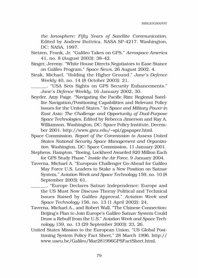
the Ionosphere: Fifty Years of Satellite Communication.Edited by Andrew Buttrica. NASA SP-4217. Washington,DC: NASA, 1997.
Sietzen, Frank, Jr. “Galileo Takes on GPS.” Aerospace America41, no. 8 (August 2003): 38–42.
Singer, Jeremy. “White House Directs Negotiators to Ease Stanceon Galileo Program.” Space News, 26 August 2002, 4.
Sirak, Michael. “Holding the Higher Ground.” Jane’s DefenceWeekly 40, no. 14 (8 October 2003): 21.
_______. “USA Sets Sights on GPS Security Enhancements.”Jane’s Defence Weekly, 16 January 2002, 30.
Snyder, Amy Paige. “Navigating the Pacific Rim: Regional Satel-lite Navigation/Positioning Capabilities and Relevant PolicyIssues for the United States.” In Space and Military Power inEast Asia: The Challenge and Opportunity of Dual-PurposeSpace Technologies. Edited by Rebecca Jimerson and Ray A.Williamson. Washington, DC: Space Policy Institute, Decem-ber 2001. http://www.gwu.edu/~spi/gpspaper.html.
Space Commission. Report of the Commission to Assess UnitedStates National Security Space Management and Organiza-tion. Washington, DC: Space Commission, 11 January 2001.
Stephens, Hampton. “Boeing, Lockheed Awarded $20 Million Eachfor GPS Study Phase.” Inside the Air Force, 9 January 2004.
Taverna, Michael A. “European Challenger Go-Ahead for GalileoMay Force U.S. Leaders to Stake a New Position on SatnavSystem.” Aviation Week and Space Technology 159, no. 10 (8September 2003): 61.
_______. “Europe Declares Satnav Independence: Europe andthe US Must Now Discuss Thorny Political and TechnicalIssues Raised by Galileo Approval.” Aviation Week andSpace Technology 156, no. 13 (1 April 2002): 24.
Taverna, Michael A., and Robert Wall. “The Chinese Connection:Beijing’s Plan to Join Europe’s Galileo Satnav System CouldDraw a Rebuff from the U.S.” Aviation Week and Space Tech-nology 159, no. 13 (29 September 2003): 23, 26.
United States Mission to the European Union. “US Global Posi-tioning System Policy Fact Sheet,” 28 March 1996. http://www.useu.be/Galileo/Mar281996GPSFactSheet.html.
79
BIBLIOGRAPHY
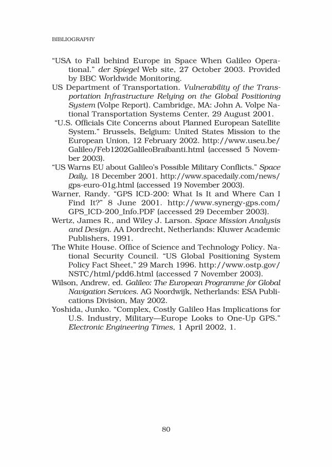
“USA to Fall behind Europe in Space When Galileo Opera-tional.” der Spiegel Web site, 27 October 2003. Providedby BBC Worldwide Monitoring.
US Department of Transportation. Vulnerability of the Trans-portation Infrastructure Relying on the Global PositioningSystem (Volpe Report). Cambridge, MA: John A. Volpe Na-tional Transportation Systems Center, 29 August 2001.
“U.S. Officials Cite Concerns about Planned European SatelliteSystem.” Brussels, Belgium: United States Mission to theEuropean Union, 12 February 2002. http://www.useu.be/Galileo/Feb1202GalileoBraibanti.html (accessed 5 Novem-ber 2003).
“US Warns EU about Galileo’s Possible Military Conflicts.” SpaceDaily, 18 December 2001. http://www.spacedaily.com/news/gps-euro-01g.html (accessed 19 November 2003).
Warner, Randy. “GPS ICD-200: What Is It and Where Can IFind It?” 8 June 2001. http://www.synergy-gps.com/GPS_ICD-200_Info.PDF (accessed 29 December 2003).
Wertz, James R., and Wiley J. Larson. Space Mission Analysisand Design. AA Dordrecht, Netherlands: Kluwer AcademicPublishers, 1991.
The White House. Office of Science and Technology Policy. Na-tional Security Council. “US Global Positioning SystemPolicy Fact Sheet,” 29 March 1996. http://www.ostp.gov/NSTC/html/pdd6.html (accessed 7 November 2003).
Wilson, Andrew, ed. Galileo: The European Programme for GlobalNavigation Services. AG Noordwijk, Netherlands: ESA Publi-cations Division, May 2002.
Yoshida, Junko. “Complex, Costly Galileo Has Implications forU.S. Industry, Military—Europe Looks to One-Up GPS.”Electronic Engineering Times, 1 April 2002, 1.
80
BIBLIOGRAPHY

GPS versus GalileoBalancing for Position in Space
Air University Press Team
Chief EditorJeanne K. Shamburger
Copy EditorTammi K. Long
Book Design and Cover Art Daniel M. Armstrong
Composition andPrepress ProductionMary P. Ferguson
Print PreparationJoan Hickey
DistributionDiane Clark