Embed Size (px)
Citation preview
Société du Grand Paris
Grand Paris Express
Evaluation of the long-term impacts with a TRANUS integrated land-use/transport model
AUM Conference, Cambridge University
November 16, 2020
Sylvie Gayda, Simon Chevalier, Mathilde Ruyssen, Victoire Vincent,
Arseni Fedosseev (STRATEC, Brussels)
Tomas de la Barra (MODELISTICA)

2
Introduction
16/11/2020
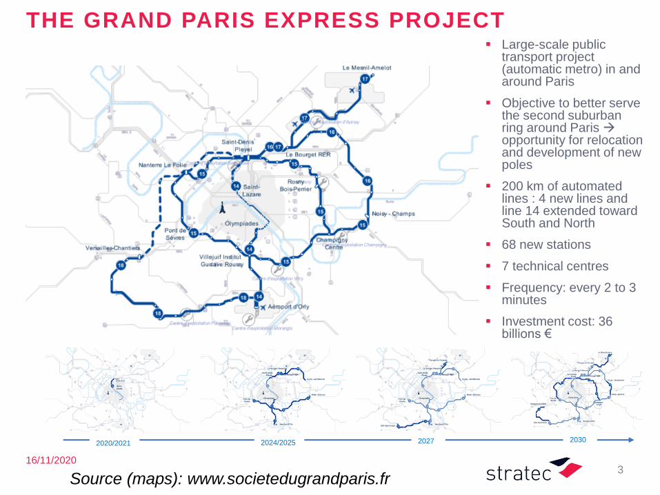
THE GRAND PARIS EXPRESS PROJECT▪ Large-scale public
transport project (automatic metro) in and around Paris
▪ Objective to better serve the second suburban ring around Paris →opportunity for relocation and development of new poles
▪ 200 km of automated lines : 4 new lines and line 14 extended toward South and North
▪ 68 new stations
▪ 7 technical centres
▪ Frequency: every 2 to 3 minutes
▪ Investment cost: 36 billions €
3
2020/2021 2024/2025 2027 2030
Source (maps): www.societedugrandparis.fr
Source: www.societedugrandparis.fr
Source: www.societedugrandparis.fr
Source: www.societedugrandparis.fr
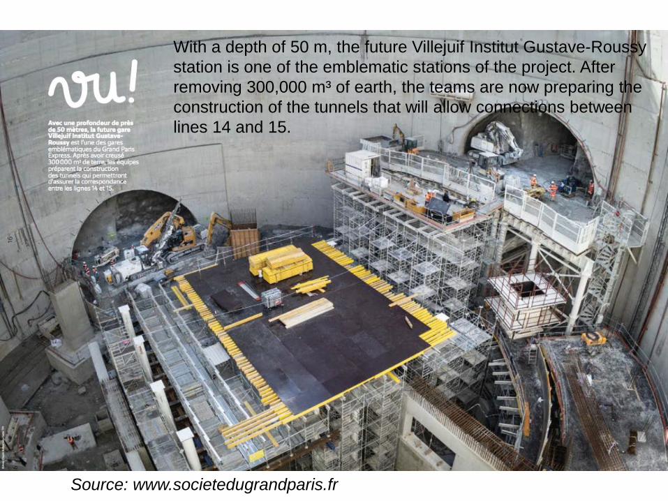
With a depth of 50 m, the future Villejuif Institut Gustave-Roussy
station is one of the emblematic stations of the project. After
removing 300,000 m³ of earth, the teams are now preparing the
construction of the tunnels that will allow connections between
lines 14 and 15.
Source: www.societedugrandparis.fr
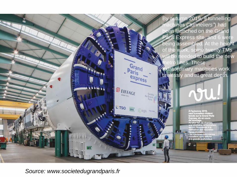
By autumn 2019, 9 tunnelling
machines (“tunneliers”) had
been launched on the Grand
Paris Express site, and 6 were
being assembled. At the height
of the work, some twenty TMs
will be needed to build the new
metro lines. These
extraordinary machines work
tirelessly and at great depth.
16/11/2020
▪ The « Société du Grand Paris » (SGP) is a public company created in 2010 by the French Government with the aim of managing the project of the « Grand Paris Express »
▪ The project mid-term impacts (horizon 2030) have previously been estimated with three LUTI models:▪ UrbanSimE (Paul Wadell and André De Palma)
▪ Pirandello model (Delons and Piron)
▪ RELU-TRAN (Alex Anas)
▪ The SGP decided to keep the UrbanSimE model as its official model for further work and to keep the results of UrbanSimE as the official results
▪ The objective of the current study is to model the longer-term effects
GRAND PARIS EXPRESS – PREVIOUS STUDIES
8
16/11/2020
ISSUES
▪ The impacts of the « Grand Paris » have been evaluated for a mid term situation (10 to 15 years), close from what we are currently experiencing
▪ However, the impacts of the « Grand Paris » will spread over time, over the lifetime of the infrastructure (>100 years)
▪ What will be the impacts of the « Grand Paris » in a situation much more far away from what we are currently experiencing with for example : ▪ A population of 14, even 15 millions of inhabitants ;
▪ Further developments in public transports (better bus feeder services, maybe an additional metro ring, …
▪ Changes in mobility behaviour
▪ Etc.
9
16/11/2020
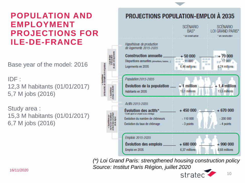
POPULATION AND EMPLOYMENTPROJECTIONS FOR ILE-DE-FRANCE
10
Base year of the model: 2016
IDF :
12,3 M habitants (01/01/2017)
5,7 M jobs (2016)
Study area :
15,3 M habitants (01/01/2017)
6,7 M jobs (2016)
(*) Loi Grand Paris: strengthened housing construction policy
Source: Institut Paris Région, juillet 2020
16/11/2020
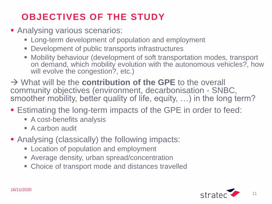
OBJECTIVES OF THE STUDY
▪ Analysing various scenarios:▪ Long-term development of population and employment
▪ Development of public transports infrastructures
▪ Mobility behaviour (development of soft transportation modes, transport on demand, which mobility evolution with the autonomous vehicles?, how will evolve the congestion?, etc.)
→ What will be the contribution of the GPE to the overall community objectives (environment, decarbonisation - SNBC, smoother mobility, better quality of life, equity, …) in the long term?
▪ Estimating the long-term impacts of the GPE in order to feed:▪ A cost-benefits analysis
▪ A carbon audit
▪ Analysing (classically) the following impacts:▪ Location of population and employment
▪ Average density, urban spread/concentration
▪ Choice of transport mode and distances travelled
11
16/11/2020
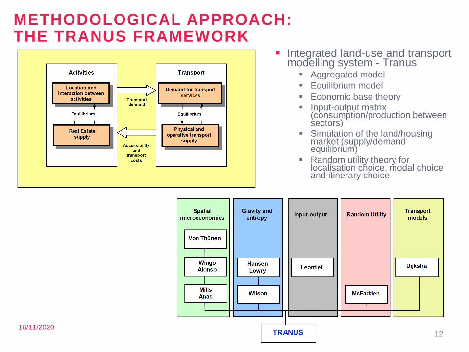
METHODOLOGICAL APPROACH:THE TRANUS FRAMEWORK
12
▪ Integrated land-use and transport modelling system - Tranus▪ Aggregated model
▪ Equilibrium model
▪ Economic base theory
▪ Input-output matrix (consumption/production between sectors)
▪ Simulation of the land/housing market (supply/demand equilibrium)
▪ Random utility theory for localisation choice, modal choice and itinerary choice
16/11/2020
A SIMPLIFIED MODEL
▪ Why ? In order to meet the objectives of the study within the available resources: ▪ (very) long term effects
▪ no need for detailed forecasts
▪ but it is critical to properly model the mechanisms, the interactions, to get the right elasticities and to get the right scale (order of magnitude) of the effects
▪ What means a “simplified model” here ?▪ The study area is large ; exchanges with the outside are minor and hence can
be modelled in a nutshell
▪ The zoning system is not much disaggregate (120 000 pers./zone)
▪ The public transport network is modelled in a schematic way
▪ The home-to-school trips are modelled exogenously
▪ The entering commuter trips (from outside the study area) and outgoing commuter trips are modelled exogenously
▪ No modelling of the freight transport
▪ Parameters have to be robust but, to some extent, not necessarily specific (may be fixed by analogy, etc.)
▪ It is no required to reconstitute precisely the base situation (2016) but well to get the right elasticities
13
16/11/2020
A WORK IN PROGRESS
▪ Current status :▪ finalisation of the land-use submodel calibration and of the
transport submodel calibration
▪ Next steps :▪ Calibration of the full LU-T-I model
▪ Simulation of the reference situation at future horizons (on the basis of the existing official population and employmentprojections)
▪ Simulation of the project situation
14

15
Model development
Study area, zoning system
16/11/2020
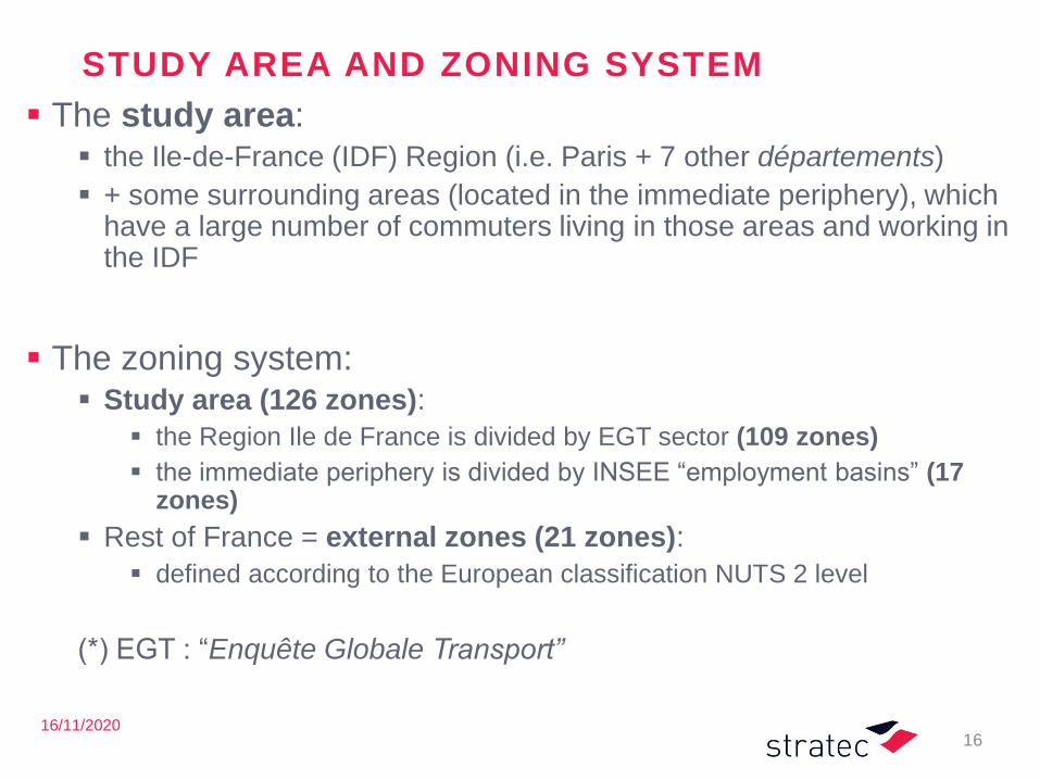
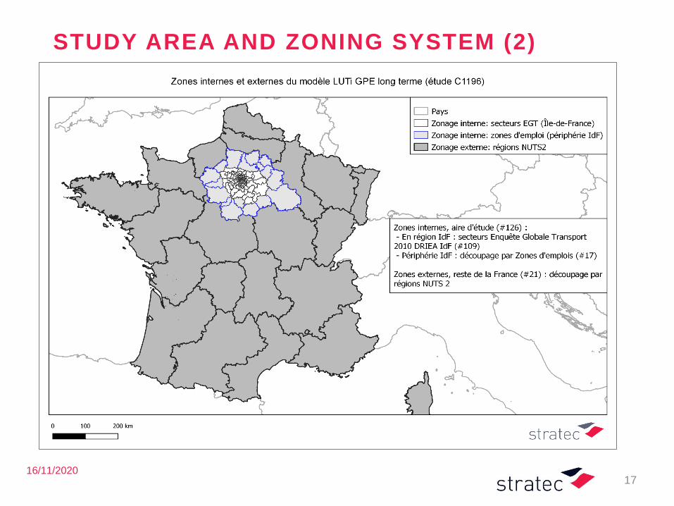
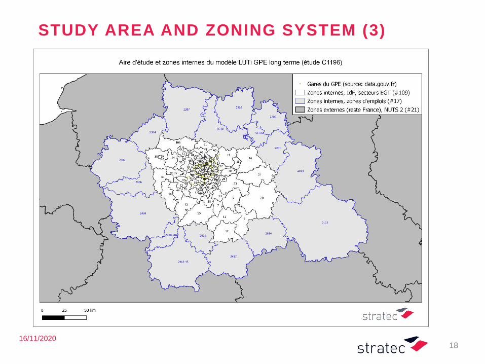
STUDY AREA AND ZONING SYSTEM
▪ The study area:▪ the Ile-de-France (IDF) Region (i.e. Paris + 7 other départements)
▪ + some surrounding areas (located in the immediate periphery), which have a large number of commuters living in those areas and working in the IDF
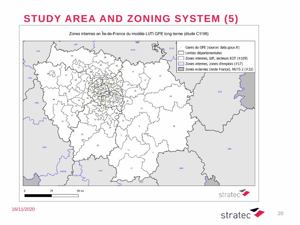
▪ The zoning system:▪ Study area (126 zones):
▪ the Region Ile de France is divided by EGT sector (109 zones)
▪ the immediate periphery is divided by INSEE “employment basins” (17 zones)
▪ Rest of France = external zones (21 zones):
▪ defined according to the European classification NUTS 2 level
(*) EGT : “Enquête Globale Transport”
16
16/11/2020
STUDY AREA AND ZONING SYSTEM (2)
17
16/11/2020
STUDY AREA AND ZONING SYSTEM (3)
18
16/11/2020
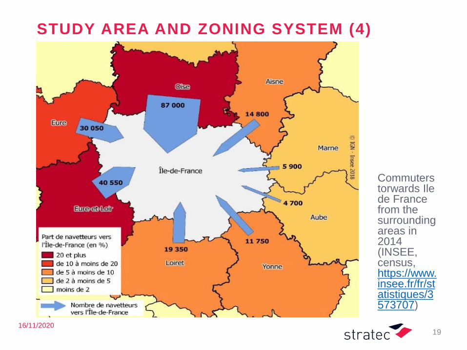
STUDY AREA AND ZONING SYSTEM (4)
19
Commuterstorwards Ile de France from the surroundingareas in 2014 (INSEE, census, https://www.insee.fr/fr/statistiques/3573707)
16/11/2020
STUDY AREA AND ZONING SYSTEM (5)
20
21
Model development
Land-use: segmentat ion of the sectors (s takeholders)
16/11/2020
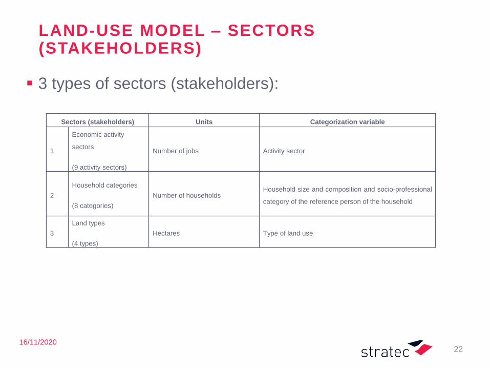
LAND-USE MODEL – SECTORS(STAKEHOLDERS)
▪ 3 types of sectors (stakeholders):
22
Sectors (stakeholders) Units Categorization variable
1
Economic activity
sectors
(9 activity sectors)
Number of jobs Activity sector
2
Household categories
(8 categories)
Number of householdsHousehold size and composition and socio-professional
category of the reference person of the household
3
Land types
(4 types)
Hectares Type of land use
16/11/2020
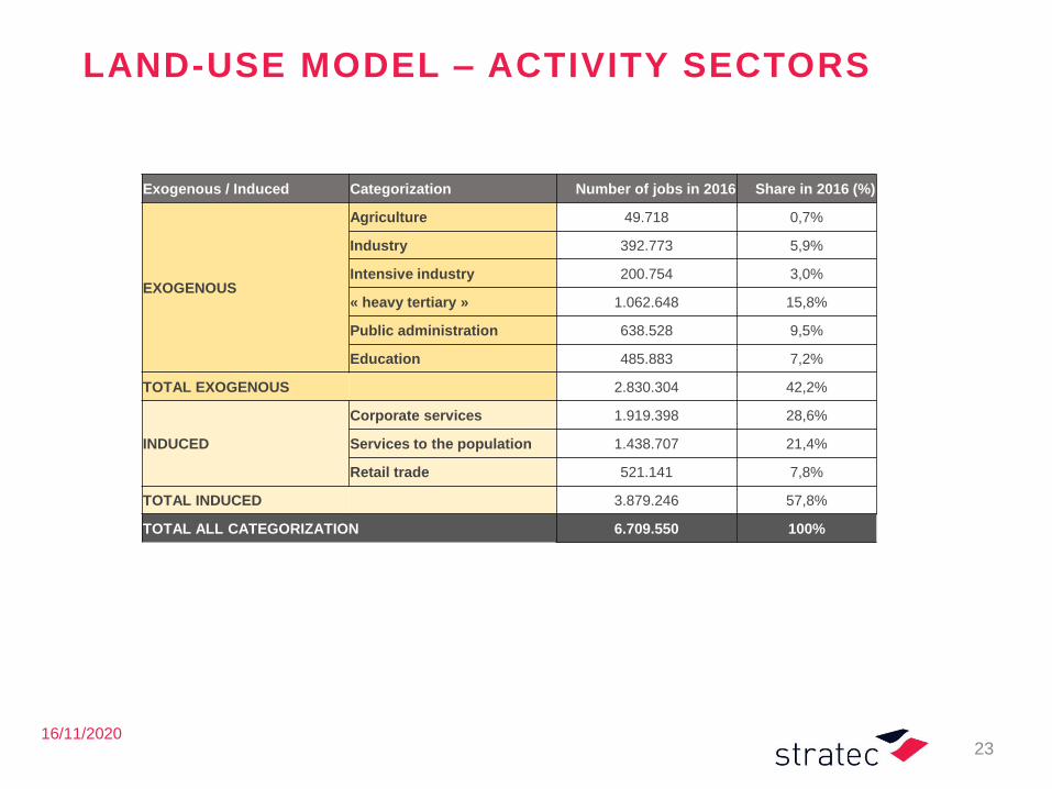
LAND-USE MODEL – ACTIVITY SECTORS
23
Exogenous / Induced Categorization Number of jobs in 2016 Share in 2016 (%)
EXOGENOUS
Agriculture 49.718 0,7%
Industry 392.773 5,9%
Intensive industry 200.754 3,0%
« heavy tertiary » 1.062.648 15,8%
Public administration 638.528 9,5%
Education 485.883 7,2%
TOTAL EXOGENOUS 2.830.304 42,2%
INDUCED
Corporate services 1.919.398 28,6%
Services to the population 1.438.707 21,4%
Retail trade 521.141 7,8%
TOTAL INDUCED 3.879.246 57,8%
TOTAL ALL CATEGORIZATION 6.709.550 100%
16/11/2020
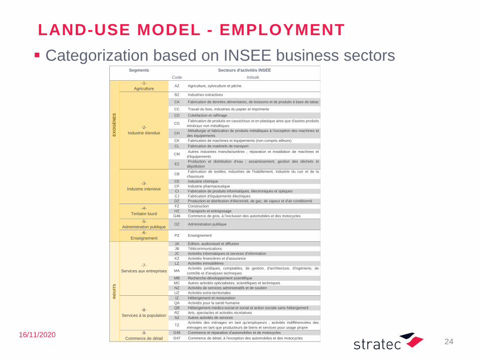
LAND-USE MODEL - EMPLOYMENT
▪ Categorization based on INSEE business sectors
24
Segments Secteurs d'activités INSEE
Code Intitulé
EX
OG
ÈN
ES
-1-
Agriculture AZ Agriculture, sylviculture et pêche
-2-
Industrie étendue
BZ Industries extractives
CA Fabrication de denrées alimentaires, de boissons et de produits à base de tabac
CC Travail du bois, industries du papier et imprimerie
CD Cokéfaction et raffinage
CG Fabrication de produits en caoutchouc et en plastique ainsi que d'autres produits
minéraux non métalliques
CH Métallurgie et fabrication de produits métalliques à l'exception des machines et
des équipements
CK Fabrication de machines et équipements (non compris ailleurs)
CL Fabrication de matériels de transport
CM Autres industries manufacturières ; réparation et installation de machines et
d'équipements
EZ Production et distribution d'eau ; assainissement, gestion des déchets et
dépollution
-3-
Industrie intensive
CB Fabrication de textiles, industries de l'habillement, industrie du cuir et de la
chaussure
CE Industrie chimique
CF Industrie pharmaceutique
CI Fabrication de produits informatiques, électroniques et optiques
CJ Fabrication d'équipements électriques
DZ Production et distribution d'électricité, de gaz, de vapeur et d'air conditionné
-4-
Tertiaire lourd
FZ Construction
HZ Transports et entreposage
G46 Commerce de gros, à l'exclusion des automobiles et des motocycles
-5-
Administration publique OZ Administration publique
-6-
Enseignement PZ Enseignement
IND
UIT
S
-7-
Services aux entreprises
JA Edition, audiovisuel et diffusion
JB Télécommunications
JC Activités informatiques et services d'information
KZ Activités financières et d'assurance
LZ Activités immobilières
MA Activités juridiques, comptables, de gestion, d'architecture, d'ingénierie, de
contrôle et d'analyses techniques
MB Recherche-développement scientifique
MC Autres activités spécialisées, scientifiques et techniques
NZ Activités de services administratifs et de soutien
UZ Activités extra-territoriales
-8-
Services à la population
IZ Hébergement et restauration
QA Activités pour la santé humaine
QB Hébergement médico-social et social et action sociale sans hébergement
RZ Arts, spectacles et activités récréatives
SZ Autres activités de services
TZ Activités des ménages en tant qu'employeurs ; activités indifférenciées des
ménages en tant que producteurs de biens et services pour usage propre
-9-
Commerce de détail
G45 Commerce et réparation d'automobiles et de motocycles
G47 Commerce de détail, à l'exception des automobiles et des motocycles
16/11/2020
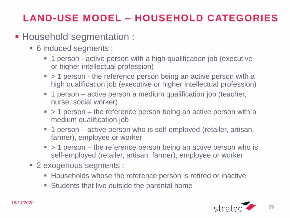
LAND-USE MODEL – HOUSEHOLD CATEGORIES
▪ Household segmentation :▪ 6 induced segments :
▪ 1 person - active person with a high qualification job (executive or higher intellectual profession)
▪ > 1 person - the reference person being an active person with a high qualification job (executive or higher intellectual profession)
▪ 1 person – active person a medium qualification job (teacher, nurse, social worker)
▪ > 1 person – the reference person being an active person with a medium qualification job
▪ 1 person – active person who is self-employed (retailer, artisan, farmer), employee or worker
▪ > 1 person – the reference person being an active person who is self-employed (retailer, artisan, farmer), employee or worker
▪ 2 exogenous segments :
▪ Households whose the reference person is retired or inactive
▪ Students that live outside the parental home
25
16/11/2020
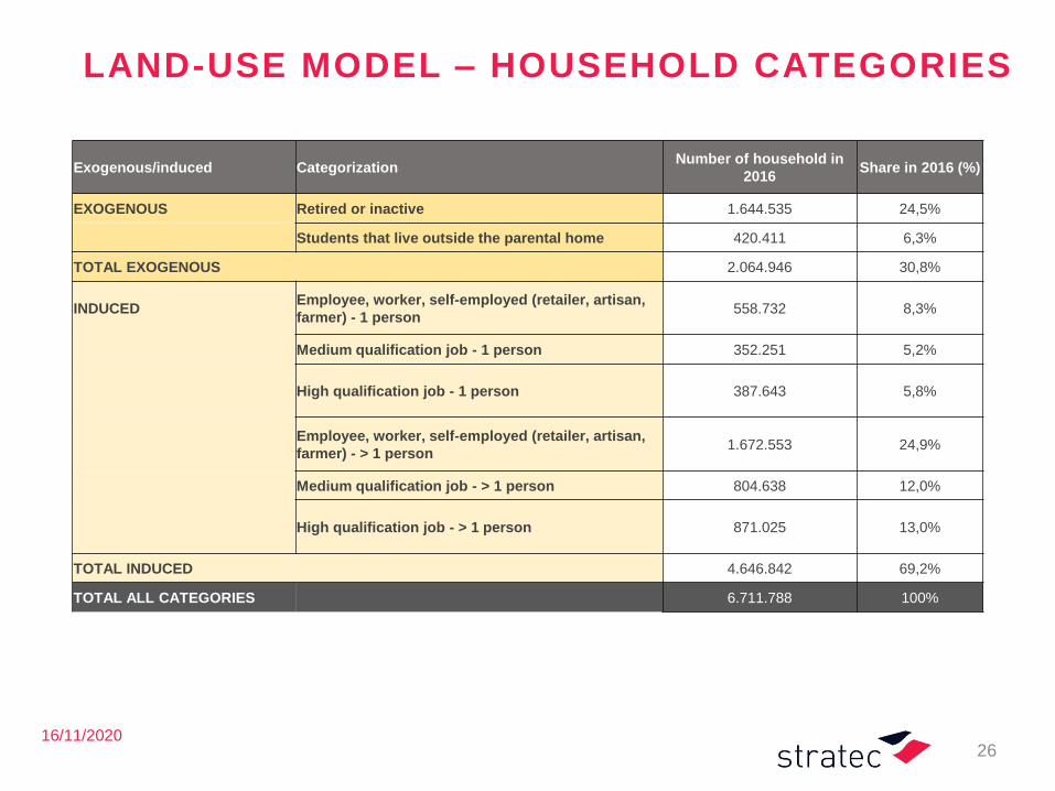
LAND-USE MODEL – HOUSEHOLD CATEGORIES
26
Exogenous/induced CategorizationNumber of household in
2016Share in 2016 (%)
EXOGENOUS Retired or inactive 1.644.535 24,5%
Students that live outside the parental home 420.411 6,3%
TOTAL EXOGENOUS 2.064.946 30,8%
INDUCEDEmployee, worker, self-employed (retailer, artisan,
farmer) - 1 person558.732 8,3%
Medium qualification job - 1 person 352.251 5,2%
High qualification job - 1 person 387.643 5,8%
Employee, worker, self-employed (retailer, artisan,
farmer) - > 1 person1.672.553 24,9%
Medium qualification job - > 1 person 804.638 12,0%
High qualification job - > 1 person 871.025 13,0%
TOTAL INDUCED 4.646.842 69,2%
TOTAL ALL CATEGORIES 6.711.788 100%
16/11/2020
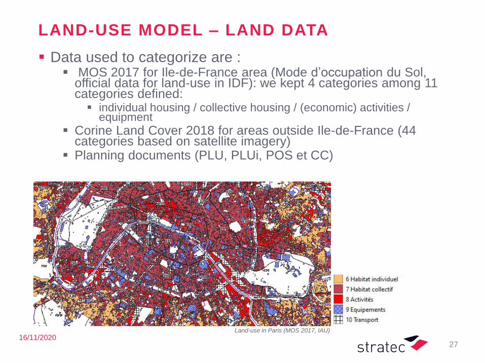
LAND-USE MODEL – LAND DATA
▪ Data used to categorize are : ▪ MOS 2017 for Ile-de-France area (Mode d’occupation du Sol,
official data for land-use in IDF): we kept 4 categories among 11 categories defined:▪ individual housing / collective housing / (economic) activities /
equipment
▪ Corine Land Cover 2018 for areas outside Ile-de-France (44 categories based on satellite imagery)
▪ Planning documents (PLU, PLUi, POS et CC)
27
Land-use in Paris (MOS 2017, IAU)
28
Model development
Land-use: input /output mat r ix
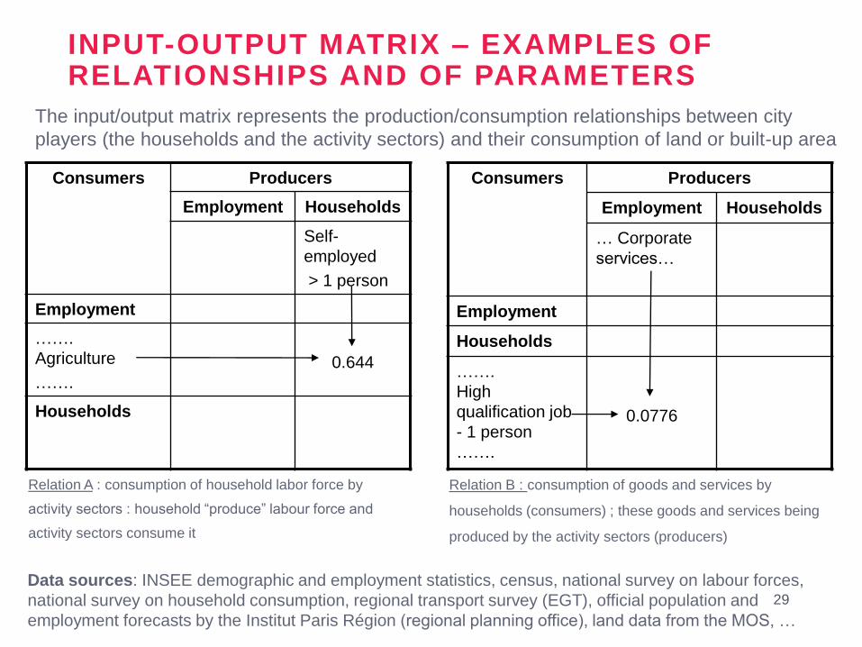
Consumers Producers
Employment Households
… Corporate
services…
Employment
Households
…….
High
qualification job
- 1 person
…….
0.0776
29
Consumers Producers
Employment Households
Self-
employed
> 1 person
Employment
…….
Agriculture
…….
0.644
Households
INPUT-OUTPUT MATRIX – EXAMPLES OF RELATIONSHIPS AND OF PARAMETERS
Relation A : consumption of household labor force by
activity sectors : household “produce” labour force and
activity sectors consume it
Relation B : consumption of goods and services by
households (consumers) ; these goods and services being
produced by the activity sectors (producers)
The input/output matrix represents the production/consumption relationships between city
players (the households and the activity sectors) and their consumption of land or built-up area
Data sources: INSEE demographic and employment statistics, census, national survey on labour forces,
national survey on household consumption, regional transport survey (EGT), official population and
employment forecasts by the Institut Paris Région (regional planning office), land data from the MOS, …

30
Model development
Transpor t model : network
16/11/2020
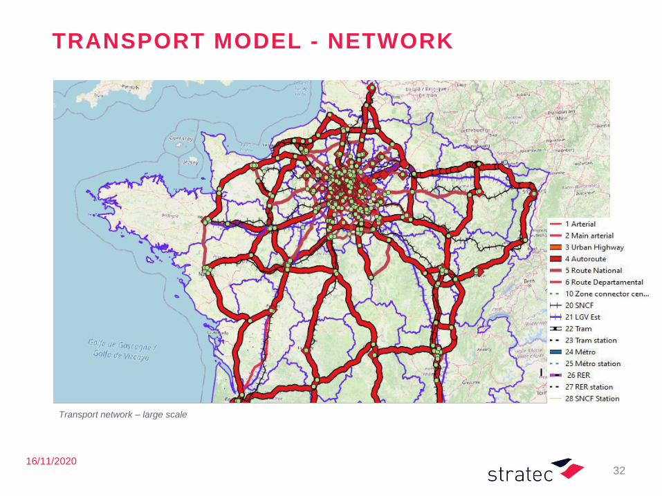
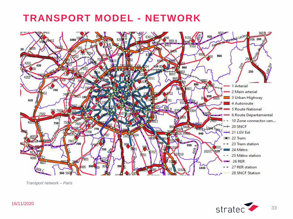
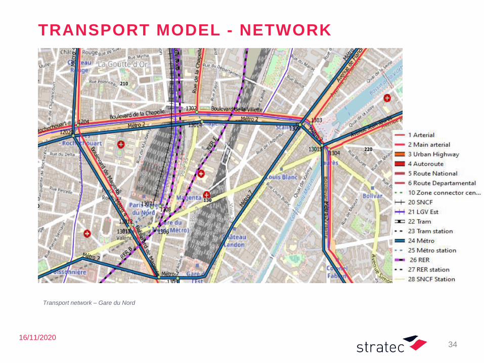
TRANSPORT MODEL - NETWORKS
▪ The road network has been developed starting from OpenStreetMap (OSM)
▪ It includes arteries, urban motorways, motorways, A-roads, B-roads,
zonal connectors for roads
▪ Easy to use in Tranus because integrated in Qgis
▪ The public transport network resumes the main components of the IDF public transport system, i.e.:
▪ SNCF lines, LGV, tram lines, tram stations, metro lines, metro stations, RER lines, RER stations, SNCF stations
▪ the bus lines are not modelled in detail but just as feeder of the rail network
▪ Network definition:
▪ 1127 nodes
▪ 955 bidirectional links road
▪ 861 bidirectional links TC
31
16/11/2020
TRANSPORT MODEL - NETWORK
32
Transport network – large scale
16/11/2020
TRANSPORT MODEL - NETWORK
33
Transport network – Paris
16/11/2020
TRANSPORT MODEL - NETWORK
34
Transport network – Gare du Nord
35
Thank you for yourattention !
36
Annexes
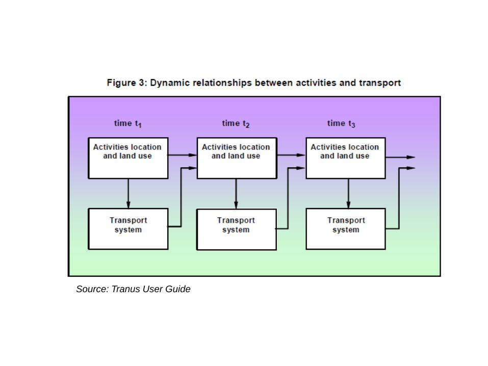
Source: Tranus User Guide
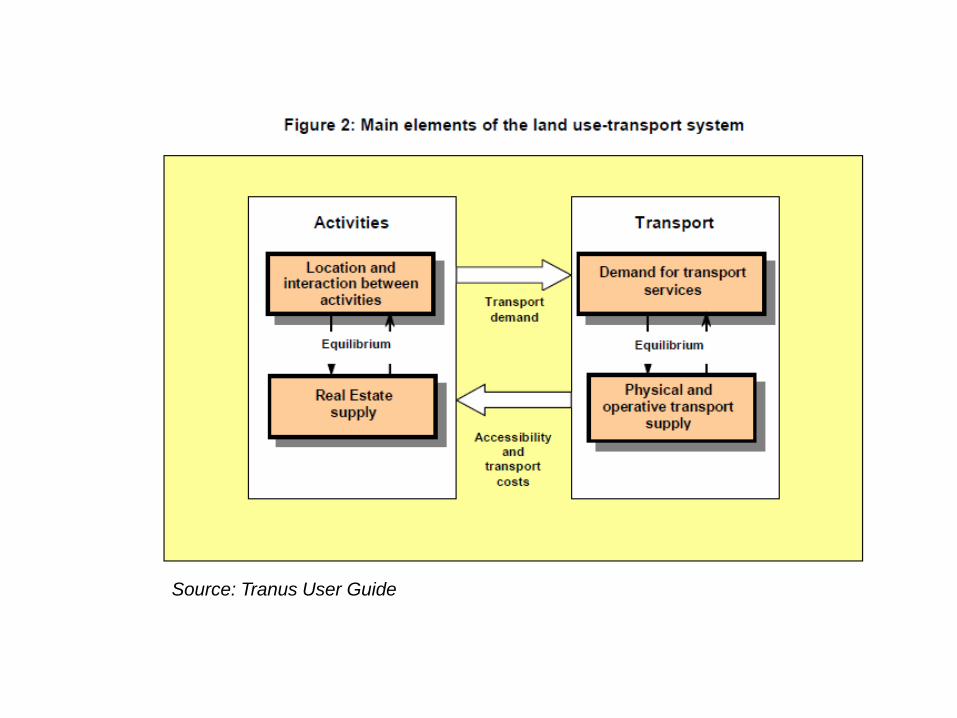
Source: Tranus User Guide
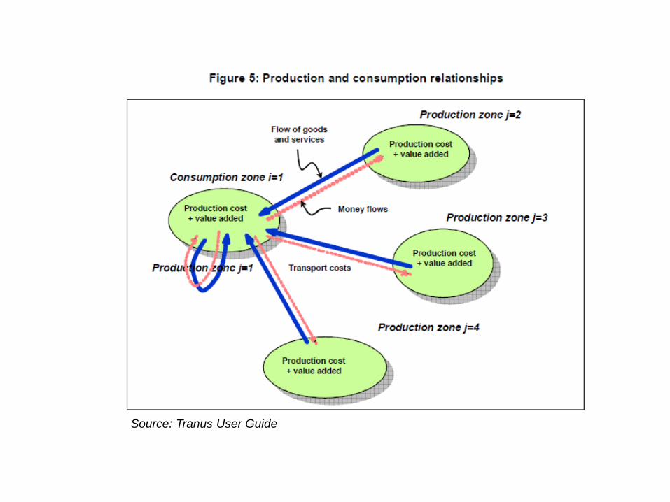
Source: Tranus User Guide
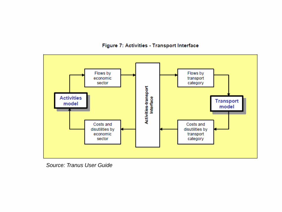
Source: Tranus User Guide
STRATEC S.A.
Avenue Adolphe Lacomblé
69-71 boîte 8
1030 Bruxelles
Belgique
+32 (0) 2 738 78 82
DES TRANSPORTS DURABLES DANS UNE SOCIÉTÉ DYNAMIQUE