Embed Size (px)
Citation preview
Any use of trade, firm, or product names is for descriptive purposes only and does not imply endorsement by the U.S. Government
Fort Collins Science Center
Grass Buffers for Playas in Agricultural Landscapes: An Annotated Bibliography
By Cynthia P. Melcher and Susan K. Skagen
Open-File Report 2005-1221
U.S. Department of the Interior U.S. Geological Survey

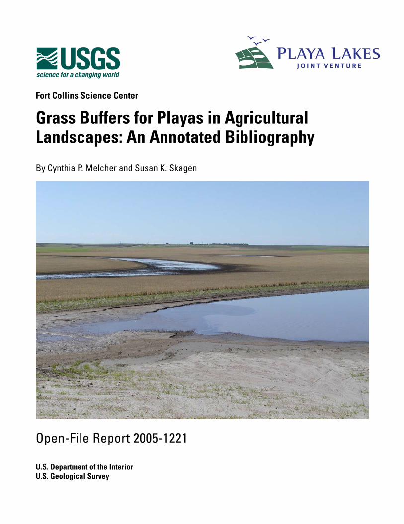
Cover photo courtesy of Ted LaGrange, NGPC
U.S. Department of the Interior GALE A. NORTON, Secretary
U.S. Geological Survey P. Patrick Leahy, Acting Director
U.S. Geological Survey, Reston, Virginia 2005 Revised and reprinted: 2005
For product and ordering information: World Wide Web: http://www.usgs.gov/pubprod Telephone: 1-888-ASK-USGS
For more information on the USGS—the Federal source for science about the Earth, its natural and living resources, natural hazards, and the environment: World Wide Web: http://www.usgs.gov Telephone: 1-888-ASK-USGS
This report is also available on-line at: http://www.fort.usgs.gov/products/publications/21488/21488.asp
Suggested citation:
Melcher, C.P., and Skagen, S.K., 2005, Grass buffers for playas in agricultural landscapes: An annotated bibliography: U.S. Geological Survey, Biological Resources Discipline, Open-File Report 2005-1221, 46 p.
Although this report is in the public domain, permission must be secured from the individual copyright owners to reproduce any copyrighted material contained within this report.
A Joint Project of the USGS and the Playa Lakes Joint Venture Monitoring, Evaluation, and Research Team
Playa Lakes Joint Venture (PLJV) Monitoring, Evaluation, and Research Team:
Reggie Blackwell U. S. Forest Service/Natural Resources Conservation Service Alison Cariveau Rocky Mountain Bird Observatory Jim Dubovsky U. S. Fish and Wildlife Service Lee Elliott The Nature Conservancy Helen Hands Kansas Department of Wildlife and Parks Bill Johnson Texas Parks and Wildlife David Klute Colorado Division of Wildlife Ted LaGrange Nebraska Game and Parks Commission Keith McKnight Ducks Unlimited Tim Mitchusson New Mexico Game and Fish Department Lynn Nymeyer U. S. Fish and Wildlife Service Mike O’Meilia Oklahoma Department of Wildlife Conservation Jim Ray BWXT Pantex, LLC
PLJV Management Board:
Merlin Bartz Natural Resources Conservation Service Ruben Cantu Texas Parks and Wildlife Cindy Correll U. S. Forest Service Barth Crouch Pheasants Forever Bill Dunn New Mexico Game and Fish Department Paul Gertler U. S. Fish and Wildlife Service Nancy Gloman U. S. Fish and Wildlife Service Mace Hack Nebraska Game and Parks Commission Richard Hatcher Oklahoma Department of Wildlife Conservation Rob Hosford Farm Services Agency Mike Johnston ConocoPhillips Joe Kramer Kansas Department of Wildlife and Parks Bob McCready The Nature Conservancy Ross Melinchuk Ducks Unlimited Jeff Ver Steeg Colorado Division of Wildlife
PLJV Staff:
Mike Carter Coordinator Karin Callahan GIS Team Leader Christopher Rustay Shortgrass Prairie Bird Conservation Region Coordinator Debbie Slobe Communications Team Leader Brian Sullivan* Biological Team Leader
*PLJV liaison to USGS for this project.
iii
Contents
Introduction.......................................................................................................................................1 Methods............................................................................................................................................2 Annotated Bibliography ....................................................................................................................3
Buffers: Design, Effectiveness, Water Retention, Models, Management, and other Best Management Practices ...............................................................................................3
Sediments and Contaminants: Processes, Effects, Transport ..............................................17 Ecology Of Playas And Other Isolated Wetlands ..................................................................20 Playa Wildlife And Invertebrates: Ecology, Responses to Contaminants, Management ......23 Personal Communications and Associated Notes ................................................................35
Additional References of Potential Interest to Buffer Researchers and Managers in the Playa Lakes Region.................................................................................................39
Acknowledgments ..........................................................................................................................43 Appendix 1. Common and Scientific Names of Avian Species Mentioned in this Document (Taxonomic Order) .........................................................................................................................44 Appendix 2. Common and Scientific Names of Plants Species Mentioned in this Document (Alphabetical Order by Common Name) ........................................................................................45 Appendix 3. Acronyms Used in this Document ..............................................................................46
iv
Grass Buffers for Playas in Agricultural Landscapes: An Annotated Bibliography
By Cynthia P. Melcher and Susan K. Skagen
Introduction
This bibliography and associated literature synthesis (Melcher and Skagen, 2005) was developed for the Playa Lakes Joint Venture (PLJV). The PLJV sought compilation and annotation of the literature on grass buffers for protecting playas from runoff containing sediments, nutrients, pesticides, and other contaminants. In addition, PLJV sought information regarding the extent to which buffers may attenuate the precipitation runoff needed to fill playas, and avian use of buffers. We emphasize grass buffers, but we also provide information on other buffer types.
There are a number of relatively synonymous terms that describe grass buffers for wetlands. They include: buffer strip, vegetated filter strip (VFS), grass buffer, grass filter, grass hedge, and grassed waterway (GW), among others (see McKague and others, 1996). Although some of these terms represent slightly different designs, placements, and/or purposes, they all perform similar functions. In this document, we use ‘buffer’ and VFS more or less interchangeably; other types are specified by name (e.g., grass hedges).
Our bibliography is by no means exhaustive, as the body of literature potentially relevant to playas and wetland buffers is vast. Thus, we attempted to include and annotate at least 1–3 papers by numerous researchers heavily involved in buffer research and modeling. We also included single papers by other researchers to increase the spectrum of regional focus, watershed/wetland conditions, research approaches, researcher expertise, and the time over which buffer theories/practices have evolved. We found virtually no literature specific to buffers for playas (confirmed by D.A. Haukos, oral. commun., 2005); thus, we conducted interviews with playa scientists to glean information on possible buffer design and management specifically for playas. We did, however, find a significant body of literature on the results of controlled experiments designed to test buffer effectiveness, an important first step towards validating buffer effectiveness in real-world situations.
Of the literature on playa ecology, flora, and wildlife, we found that most focuses on playa basins and wetlands rather than the surrounding uplands and grasslands; furthermore, most of the empirical work on playa ecology has taken place in the Southern High Plains (SHP; i.e., Texas and Okalahoma panhandles, southeastern Colorado, and southwestern Kansas) because many wetlands in other portions of the PLJV region (Fig. 1) were only recently recognized as playas. Finally, we found few papers on avian use of buffers; therefore, we focused on those that report on avian use of Conservation Reserve Program (CRP) fields or lands enrolled in similar programs.
References on best management practices (BMPs) for agricultural lands were included because certain BMPs are crucial for informing decisions about buffer design/ effectiveness and overall playa ecology. We also included various papers that increase the spectrum of time over which buffer theories and practices have evolved. An unannotated section lists references that we did not prioritize for annotation and references that may be helpful but were beyond the scope of this document. Finally, we provide notes on conversations we had with scientists, land managers, and other buffer experts whom we consulted, and their contact information. We conclude the bibliography with appendices of common and scientific names of birds and plants and acronyms used in both the bibliography. In the annotations, italicized text signifies our own editorial remarks. Readers should also note that much of the work on buffers has been designed using English units of measure rather than metrics; in most cases, their results have been converted to metrics for publication, explaining the seemingly odd or irregular buffer widths and other parameters reported.
1
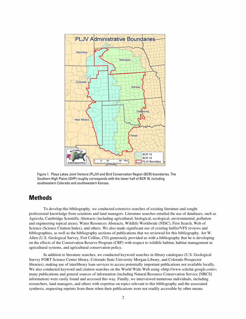
Figure 1. Playa Lakes Joint Venture (PLJV) and Bird Conservation Region (BCR) boundaries. The Southern High Plains (SHP) roughly corresponds with the lower half of BCR 18, including southeastern Colorado and southwestern Kansas.
Methods
To develop this bibliography, we conducted extensive searches of existing literature and sought professional knowledge from scientists and land managers. Literature searches entailed the use of databases, such as Agricola, Cambridge Scientific Abstracts (including agricultural, biological, ecological, environmental, pollution and engineering topical areas), Water Resources Abstracts, Wildlife Worldwide (NISC), First Search, Web of Science (Science Citation Index), and others. We also made significant use of existing buffer/VFS reviews and bibliographies, as well as the bibliography sections of publications that we reviewed for this bibliography. Art W. Allen (U.S. Geological Survey, Fort Collins, CO) generously provided us with a bibliography that he is developing on the effects of the Conservation Reserve Program (CRP) with respect to wildlife habitat, habitat management in agricultural systems, and agricultural conservation policy.
In addition to literature searches, we conducted keyword searches in library catalogues (U.S. Geological Survey FORT Science Center library, Colorado State University Morgan Library, and Colorado Prospector libraries), making use of interlibrary loan services to access potentially important publications not available locally. We also conducted keyword and citation searches on the World Wide Web using <http://www.scholar.google.com>; many publications and general sources of information (including Natural Resource Conservation Service [NRCS] information) were easily found and accessed this way. Finally, we interviewed numerous individuals, including researchers, land managers, and others with expertise on topics relevant to this bibliography and the associated synthesis, requesting reprints from them when their publications were not readily accessible by other means.
2
Annotated Bibliography
Buffers: Design, Effectiveness, Water Retention, Models, Management, and Other Best Management Practices
Abu-Zreig, M., 2001, Factors affecting sediment trapping in vegetated filter strips: Simulation study using VFSMOD: Hydrological Processes, v. 15, p. 1477–1488.
The model, VFSMOD, validated with field data from 21 VFSs, predicts that filter width has the greatest affect on sediment-trapping efficiency (STE), but that this relationship is nonlinear. Sediment size is also important (larger particles are trapped more efficiently than smaller particles); VFSs of 15 m trapped only 47% of clay particles compared to 92% for silt. STE also increased with roughness coefficient, which tended to be greater in narrow VFSs due to increased stem densities.
Authors’ note: Apparently these and some other agricultural engineers involved in studying VFS effectiveness define width and length opposite of the way we define them. Throughout this document, we standardized all references to buffer or filter width as the distance [of the buffer] between a source of runoff and a protected resource, and length as the distance along the lower edge of a source of runoff.
Abu-Zreig, M., Rudra, R.P., and Whiteley, H.R., 2001, Validation of a vegetated filter strip model (VFSMOD): Hydrological Processes, v. 15, p. 729–742.
This paper reports on a series of tests to validate a process-based STE model, VFSMOD. The model uses 25 variables from 5 different files. It was tested with data collected during experiments of the STE of different VFS widths (0, 2, 5, 10, 15 m), slopes, and vegetation characteristics (stem density and height). Overall, the model’s predictions of STE closely matched the observed efficiencies (R2 = 0.9); the model’s predicted volume of infiltration also closely matched that of observed infiltration (R2 = 0.95). What makes this model different from some others is its hydrological component, taking into account not only rainfall amount/intensity and runoff characteristics (e.g., velocity, turbulence), but also infiltration (e.g., soil-water moisture, soil texture).
Abu-Zreig, M., Rudra, R.P., Whitely, H.R., Lalonde, M.N., and Kaushik, N.K., 2003, Phosphorus removal in vegetated filter strips: Journal of Environmental Quality, v. 32, p. 613–619.
This study, conducted in outdoor plots in Ontario, evaluated the effect of VFS widths on runoff of phosphorus (P) and sediment under simulated rainfall. Filter lengths were standardized at 1.2 m. Soils were characterized as silt loam with 38% sand, 54% silt, and 8% clay. In a somewhat imbalanced design, the authors evaluated effects of varying filter lengths (2, 5, 10, 15 m), inflow rates, slopes, and filter covers (1 = perennial ryegrass, 5-m widths only; 2 = legume/creeping red fescue mix; 3 = “native grasses,” 5-m widths only; and bare ground---control of only 5-m widths) on reducing P and sediments. Slope was 2.3% for all plots except those planted with native grass (5% slope). Vegetation cover ranged from 40–65% in the legume/fescue mix, to 70–83% in the two other vegetated cover types. The native grasses were well-established; the other two vegetation types were recently established. Experiments were conducted on previously moistened soil (results could be different in arid or semi-arid regions, where soils may be dry when runoff occurs).
Reductions of both P and sediment were highly correlated (positively) with filter width. Slope, vegetation type, and inflow rate had only secondary influences on amounts trapped. Average phosphorus-trapping efficiency (PTE ) was 61%; the 2-m filters trapped 31% and the 15-m filters trapped 89%. In another paper by Abu-Zreig and others (2004), an average of 89% of the sediment was trapped in the same buffers (range 68–98%). At filter widths >10 m, filtering efficiency declined, especially STE; wider filters, however, are expected to result in additional PTE. However, as filters (especially narrow ones) become saturated with sediments, they may become less effective. Primary mechanisms for trapping P were deposition of sediments to which P was attached, infiltration, and adsorption by plants. More P can bind to finer sediments (i.e., silt, clay) than coarse sediments, and narrow strips are not usually enough to trap fine sediments; thus, wider strips will be needed to trap more P in finer soils.
Among all 5-m wide strips, the plots with native grasses trapped the most P (65–72%, mean 68%), although the difference between native and the next-best performer (perennial ryegrass) was not significant. Native
3
grasses performed even better under low-flow regimes---better than strips of 10 and 15 m planted with the legume/fescue mix---and the slopes of the native grass buffers were twice those of other plots; the authors attribute this difference to greater cover in native-grass plots. However, the native-grass plots retained more water (39–58% v. 37–44% in legume/fescue mix) due to greater cover and a rougher surface. Lower runoff velocities and more infiltration resulted in more P removal. The extent to which infiltration represented loss of overland water flow was not discussed.
Abu-Zreig, M., Rudra, R.P., Lalonde, M.N., Whiteley, H.R., and Kaushik, N.K., 2004, Experimental investigation of runoff reduction and sediment removal by vegetated filter strips: Hydrological Processes, v. 18, p. 2029–2037.
Sediment transport is disrupted by vegetation in VFSs by (1) decreasing the velocity of water passing through the strip (thus allowing sediments to settle within the VFS), and (2) increasing water infiltration (thus, depriving sediments of transport beyond the VFS). This is an experimental study designed to test VFS efficiency. It entailed evaluating the sediment runoff after simulated rainfall from 20 VFSs of various widths (0–15 m; in this paper, as in many papers on buffers conducted by agricultural engineers, VFS width is referred to as length), VFS vegetation cover (0–83%), and slope (2.3 and 5%). The experimental design tested the effect of filter width with one vegetation type. Effects of vegetation structure were tested at a constant filter width of 5 m at slopes of 2.3 and 5%. VFSs were 0 (controls), 2, 5, 10, and 15 m wide. The STE of VFSs ranged from 25% in controls and 68% in 2-m VFSs to 98% in 15-m filters; however, increasing the VFS from 10 to 15 m did not improve efficiency in this set of experiments. Although lower flow velocity of water entering the VFS and greater percent vegetation cover increased VFS efficiency, filter width had the far greater effect on trapping sediments.
Perhaps the most-important component of this study---something few others have addressed---was evaluation of water retention (infiltration) in the VFSs. Infiltration was largely a function of filter width and stem density of the VFS. In 2-m-wide filters, 20% of the runoff was retained, whereas in the 10-m-wide filters, 62% was retained.
Arora, K., Mickelson, S.K., Baker, J.L., Tierney, D.P., and Peters, C.J., 1996, Herbicide retention by vegetative buffer strips from runoff under natural rainfall: Transactions of the American Society of Agricultural Engineers, v. 39, p. 2155–2162.
An important factor affecting runoff of agricultural chemicals are their soil-adsorption capabilities, which can range from low to high for herbicides. This paper reports on a 2-year study of how effectively VFSs retained herbicides during natural rainfall events in Iowa. The source area, 0.41 ha on silty clay loam soils with an average slope of 3%, was chisel-plowed in the fall, then disked the next spring before corn was planted. Each spring, atrazine, metolachlor, and cyanazine (all exhibiting moderate soil-adsorption capabilities) were applied to the corn field. Rainfall runoff was collected and held in a mixing tank before being released onto six 20.12-m VFSs planted with well-established brome grass: 3 VFS replicates received a drainage-to-buffer area ratio of 15:1 and three received a ratio of 30:1. Herbicide retention varied from 11–100%, depending on antecedent moisture conditions, and was similar for all three herbicides; however, there was no significant effect of drainage-to-buffer area ratio. Herbicide retention was due primarily to infiltration; only ~5% of the reduction in herbicide runoff was attributable to adsorption by sediment retained in VFSs. Overall, VFSs would be more useful for retaining herbicides that adsorb strongly to sediments and other suspended solids.
Baker, J.L., Mickelson, S.K., Hatfield, J.L., Fawcett, R., Hoffman, D.W., Franti, T.G., Peter, C.J., and Tierney, D.P., 1995, Reducing herbicide runoff: role of best management practices: Brighton Crop Protection Conference Proceedings, Brighton, England.
A review of work conducted from 1970–1990 revealed that conservation tillage reduced the amount of applied herbicides from entering runoff by ~60%.
Barfield, B.J., Blevins, R.L., Fogle, A.W., Madison, C.E., Inamdar, S., Carey, D.I., and Evangelou, V.P., 1998, Water quality impacts of natural filter strips in karst areas: Transactions of the American Society of Agricultural Engineers, v. 41, p. 371–381.
This study was conducted to test the trapping effectiveness of riparian grass buffers on sediments, nutrients, and herbicides in a region of Kentucky characterized by karst soils underlain by limestone; karst soils contain numerous macropores---i.e., high level of soil porosity---and limestone bedrock contains many channels. Runoff was simulated in no-till and conventional tillage plots, which were buffered by grass strips 4.57, 9.14, and 13.72 m
4
wide. The trapping efficiency of both sediments and pollutants was >90%. As buffer width increased, more infiltration---thus pollutant trapping---occurred.
This paper was included herein to underscore the effects of soil porosity and infiltration on buffer effectiveness.
Black, A.L., and Aase, J.K., 1988, The use of perennial herbaceous barriers for water conservation and the protection of soils and crops: Agriculture, Ecosystems and the Environment, v. 22/23, p. 135–148.
In Montana, grass hedges (tall wheatgrass) spaced ~15 m apart diminished wind erosion of soil by ~93% annually when compared to unhedged fields. Grass hedges also caused ponding of runoff on their upslope sides, thus increasing infiltration of water into the soil.
Boatman, N.D., and Sotherton, N.W., 1988, The agronomic consequences and costs of managing field margins for game and wildlife conservation: Aspects of Applied Biology, v. 17, p. 47–56.
This paper reviews a BMP that entails establishing >6-m wide no-application zones, known as ‘conservation headlands,’ for pesticides around field margins. This practice allows the survival of some forbs and herbs, as well as invertebrates, which can be crucial for brood rearing of many terrestrial and aquatic birds. The paper also provides an analysis of the agricultural consequences and economic costs associated with conservation headlands, including weed growth and grain yield, grain-moisture content, grain contamination by weed seeds, interference with harvesting, and aphid damage. At the time this paper was published, farmers were finding that the costs incurred from conservation headlands were acceptable, given the benefits; however, the authors conclude by saying that, if grain prices were to continue declining, farmers may be less amenable to this BMP unless their costs are subsidized.
Castelle, A.J., Johnson, A.W., and Conolly, C., 1994, Wetland and stream buffer size requirements -- a review: Symposium on Wetland Processes and Water Quality, Minneapolis, MN, 3–4 November 1992.
This paper is a literature review and synthesis of specific buffer functions with respect to buffer size. The authors define buffer as either undisturbed, native vegetation, or as an area revegetated after some form of disturbance. Typically, buffer-size requirements have been established according to political acceptability as opposed to scientific merit. Effective buffer widths ranged from 3 m to 200 m, depending on site-specific conditions; a minimum of 15 m is necessary to protect wetlands and streams under most conditions. Overall, buffer-width requirements for reducing sediments (10–60 m) were smaller than those required for nutrient removal (5–90 m) and enhancing species diversity (5 – 100+ m). Buffers that promote sheet flow as opposed to channelized flows enhance settling and infiltration. Certain vegetation types were found to uptake and/or accumulate chromium, copper, lead, manganese, selenium, strontium, and zinc, all of which have been found at high levels in playa basins (see Irwin and others, 1996).
Wong and McCuen (1982) noted a nonlinear relationship between buffer size and percent sediment removal desired. For example, if the criterion of percent sediment removal on a 2% slope was increased from 90 to 95%, the required buffer width doubled from 30.5 to 61 m. Ghaffarzadeh and others (1992) found that grass buffers 9.1-m wide trapped 85% of sediments at both 7 and 12% slopes, that STE did not increase in buffers > 9.1 m wide, and that sediment removal at both slopes did not differ in buffers >3.1 m.
Several studies of feedlot runoff showed a wide variation in the ratio of buffer width to reductions in solids and sediments in runoff, ranging from 33% removed by a 22.8-m buffer, to 92% removed by a 24.4-m buffer, and 80% removed by a 61-m buffer.
Dewald, C.L., Henry, J., Bruckerhoff, S., Ritchie, J., Dabney, S., Sheperd, D., Douglas, J., and Wolf, D., 1996, Guidelines for establishing warm season grass hedges for erosion control: Journal of Soil and Water Conservation, v. 51, p. 16–20.
This paper contains general information on selecting grasses/seed quality, preparing seedbeds, planting times, planting rates (seed densities), planting procedures, and management procedures for grass hedges.
Dillaha, T.A., 1990, Role of best management practices in restoring the health of the Chesapeake Bay, in Perspectives on the Chesapeake Bay, 1990: Advances in Estuarine Sciences. CBP/TRS41/90. Chesapeake Bay Program, U.S. Environmental Protection Agency, Washington. DC. Available online at: <http://www.bse.vt.edu/Courses/BSE4324/Lecture11_BMPs-Assessments%20of%20Effectiveness.html>.
5
Among other things, this is an excellent review of BMPs (including buffers) for conserving topsoil and protecting wetlands and water quality. It also includes monitoring considerations and approaches, comparisons of the cost-effectiveness of different buffers, and it discusses the capabilities, limitations, and outputs of various models designed to predict sediment and pollutant transport, among other things. Each model differs from the rest in terms of spatial and temporal scale, input variables and output parameters, and so on. Finally, this paper summarizes research needs with respect to effective BMPs (including buffers).
Dillaha, T.A., Sherrard, J.H., and Lee, D., 1986, Long-term effectiveness and maintenance of vegetative filter strips, VA: Water Resources Research Center, Bulletin 153, Blacksburg, Va, 39 p.
This is the long, detailed version of the study described in Dillaha and others (1989b; see below). It also includes a literature review and details/specifications of Virginia’s VFS program for buffering riparian areas. Virginia’s program requires buffers to average 20 feet wide (taking into account irregularities such as boundaries and fencing), with a minimum of >12 feet; widths of 10 feet are acceptable where slopes are <2%. No-till BMPs are preferred, and removal of trees, stumps, shrubs and other materials that disrupt the evenness and density of grass in a VFS is recommended, as they impair buffer effectiveness. Filter strips are likely to be totally ineffective as wildlife habitat, as most wildlife prefer grass densities too sparse for adequately retarding runoff.
Dillaha, T.A., Reneau, R.B., Mostaghimi, S., and Lee, D., 1989a, Vegetative filter strips for agricultural nonpoint source pollution control: Transactions of the American Society of Agricultural Engineers, v. 32, p. 513–519.
VFSs of 0, 4.6, and 9.1-m widths in Virginia silt loam soils were evaluated within experimental field plots ranging in slope from 5–16 degrees. Plots were designed so that runoff would flow in an even, shallow sheet (cross slopes of <1%) or directed in drainageways (cross slopes of up to 4%). Cropland portions of plots were tilled conventionally, N and P were applied, and then rainfall at an intensity of 50 mm/hr was simulated 4 times over one week (200 mm).
Significantly more sediment, P, and N were lost from plots with no VFS. Sediment, P, and N reductions increased significantly with filter width; 4.6-to 9.1-m VFSs removed a mean of 70 to 84% of the suspended solids, 61 to 79% of the total P, and 54 to 73% of the N, respectively. Percent P and N removed correlated closely with percent sediment removed because the majority of P and N were sediment-bound. Sediment reduction was similar on 5 and 11% slopes, but reduction was greatly diminished at 16% slopes. A similar trend was found for P and N; however, during repeated rainfall simulations, previously sediment-bound P likely dissolved and was released, and N not bound to sediments or volatilized escaped VFSs as residual organic N. The resulting P and N in outflows would have been enough to cause eutrophication in wetland catchments.
Most sediments were deposited just upslope, or in the first few meters, of the VFSs. As sediments buried the upslope area of the VFSs, however, they spilled downslope to the next portion of the VFSs until they were buried, and so on. On 5% slopes, VFSs absorbing directed flows (i.e., formation of draingeways) were generally as effective as those absorbing even sheet flows, and they were more effective than VFSs absorbing even sheet flows on 16% slopes. Apparently, for a given watershed, the directed flows at 5% slopes carried proportionately smaller volumes of sediments by the time they directed than they would have had they not become directed, thus somewhat making up for the minimized sediment-trapping efficiency under more directed flows. Overall, however, VFSs became less effective with each subsequent rainfall; in real world situations, it’s not clear whether this problem could be mitigated by vegetation capable of growing up through accumulated sediments.
Inspection of existing VFSs at 18 area farms showed that real-world VFSs may not be as effective as experimental VFSs, particularly at higher runoff volumes and at steeper slopes. They must absorb much larger areas of runoff that tend to concentrate runoff in a few natural drainageways that cut across the VFSs rather than flowing in even sheets through the VFSs. In flatter areas, where VFSs had worked well, so much sediment built up that VFSs become more like terraces, often leading to directed flows where low spots remained.
Dillaha, T.A., Sherrard, J.H., and Lee, D., 1989b, Long-term effectiveness of vegetative filter strips: Water, Environment & Technology, v. 1, p. 419–421.
Most research on the effectiveness of VFSs and other buffers has been limited almost entirely to controlled experiments in greenhouses or field plots. To develop a preliminary picture of real-world buffer effectiveness and maintenance, the authors conducted site visits at 33 farms, in rural Virginia. Site visits were repeated 4 more times in 13 months where VFSs still existed and functioned as buffers (74%). The authors included VFSs of varying ages, and measured buffer width, slope, vegetation characteristics, land use of the adjacent land, runoff
6
flows/concentrations, vegetation cover, maintenance needed, and landowner perspectives. Most of the VFSs were predominantly tall fescue, although other species were present. Surveys were mailed to farmers after site visits to solicit their feedback regarding buffer effectiveness and needs for improving them.
VFSs were 3 to 9 m wide (ave. 5.8 m). Most newer buffers were planted to 6 m, but over time tilling adjacent croplands encroached on them. Twenty percent of the VFSs had significant gully/erosion problems; most gullies were localized but they severely compromised VFS effectiveness for water-quality protection. In 29% of the VFSs, weed problems were apparent, outcompeting (shading) the grasses. The authors suggest that mowing, herbicide applications (although this seems counter-intuitive if one is attempting to filter herbicides out of runoff), and reseeding would have improved the VFSs. Nearly 1/5th of the VFSs were damaged due to farm traffic/turning equipment, and a few were damaged by trampling from cattle.
Overall, VFSs in hilly landscapes were most damaged by directed runoff; those in smaller watersheds had fared better. VFSs planted within (across) drainageways would have helped buffer the buffers. About 1/3 of the farmers surveyed indicated that they would continue installing buffers even without cost-sharing, another third would not, and the remaining were not sure.
Recommendations for establishing and maintaining VFSs are provided. However, their recommendations may be counter-indicated in some instances (e.g., their recommendation to mow VFSs three times per year would probably result in significant nesting failures among breeding birds). Perhaps the maintenance recommendations most-applicable to playa buffers is to repair them when breached by gully erosion, disk/reseed them if sediments accumulate enough to develop terraces, and avoid using them as 2-tracks or turn-arounds for farm equipment.
Dosskey, M.G., 2001, Toward quantifying water pollution abatement in response to installing buffers on crop land: Environmental Management, v. 28, p. 577–598.
This literature review examines the extent to which buffers diminish nonpoint source pollution, summarizes the factors that most influence buffer effectiveness, and identifies major gaps in our knowledge on buffers. Overall, studies have yet to quantify direct measures of pollution abatement (i.e., amount of pollutants passing through or bypassing buffers and entering wetlands); rather, studies have focused on indirect measures, such as sediment retention, runoff volume, etc. Buffer research clearly shows that buffers accrue benefits in terms of diminishing erosion, sediment, and sediment-bound pollutants, but the extent to which they improve the situation over that of unbuffered wetlands is unclear. As conditions vary even in minor ways, results of runoff experiments can vary widely. Models for predicting runoff and associated pollutants have proven promising, but more work is needed in this realm, and, for now, a great deal of ‘professional judgment’ is still required to extrapolate current knowledge of buffer functions into only broadly accurate estimates of water pollution abatement.
Dosskey, M.G., Schultz, R.C., and Isenhart, T.M., 1997a, A riparian buffer design for cropland: Agroforestry Notes, January 1997, no. 5. National Agroforestry Center, Lincoln, Nebraska.
The authors provide a general buffer design for riparian systems. Their standard design is a 50-foot wide buffer composed of a 20-foot wide strip of 2 rows of fast-growing trees (planted 6–10 feet apart) immediately adjacent to the riparian corridor, then a 10-foot wide strip of 2 rows of shrubs (planted 3–6 feet apart), and finally a 20-foot wide strip of grass. The first two strips (trees and shrubs) are meant to stabilize the streambank, while the grass is meant to slow and disperse runoff---thus promoting the settlement of sediments and the infiltration of nutrients and pesticides, albeit limited control.
Narrower buffers reduce control over nutrients and pesticides, and require a more careful selection of suitable vegetation species to accomplish goals similar to that of the standard design. Wider buffers can promote further control over runoff of pesticides and nutrients, although the proportion of pesticide and nutrient control diminishes with each additional unit of buffer width.
To filter sediments from agricultural lands, the authors suggest making a narrower buffer with a larger grass section. Dense, stiff grasses may outperform bunchgrasses and short, flexible grasses in filtering sediments. To filter soluble nutrients and pesticides, the buffer should be wider and include fast-growing grasses (and/or trees). Deep-rooted grasses may perform better at filtering nutrients and pesticides than shallow-rooted grasses.
Dosskey, M.G., Schultz, R.C., and Isenhart, T.M., 1997b, Riparian buffers for agricultural land: Agroforestry Notes, January 1997, no. 3. National Agroforestry Center, Lincoln, Nebraska.
7
As filters for sediments, buffers perform best for filtering larger-sized sediments (e.g., sand, soil aggregates) and crop residues, but they are less effective at filtering clay sediments. Periodically, sediments may have to be removed from buffers, especially where sediment loads are heavy. As filters for nutrients, pesticides, herbicides, and animal wastes, buffers can effectively filter particulates and contaminants attached (bound, undissolved) to sediments. Soluble contaminants may be uptaken and transformed by soil microbes and vegetation in the buffer, and they are further diluted by rain while in the buffer itself. Buffers are less effective for filtering dissolved nutrients and pesticides, although nitrates may be removed effectively as they pass through shallow groundwater under wetland conditions. Periodic harvest of buffer vegetation may be required to remove the nutrient loads they contain; the sediments built up around the vegetation also may require removal. The authors advocate connecting buffers in a riparian context but do not discuss buffers for isolated wetlands.
Feldhake, C.M., and Boyer. D.G., 1995, Soil water depletion by C3 and C4 pasture grasses in central Appalachia: Journal of Soil and Water Conservation, v. 50, p. 106–109.
The authors report that growing C4 grasses at high elevations in West Virginia may result in decreased soil water depletion, which in the long run could result in higher water yield in streams. C4 grasses generally do not begin growing and taking up water until after the last frost, whereas C3 grasses can grow until severe cold occurs. They may affect soil water in surface layers accordingly. This paper reports on experiments at elevations of 2,000 and 3,000 feet in West Virginia, where first heavy frosts occurred at both sites simultaneously. Plots were in fields on nearly level ridgetops. The C3 grass was orchardgrass, and the C4 grasses were switchgrass---which grows tall--and bermudagrass---which grows in short, dense mats. C4 pastures were treated with atrazine to control C3 weeds. Soil water was measured weekly (or more often) at depths ranging from 20–80 cm.
At the higher site, the C3 grass depleted soil water more than the C4 grasses, possibly because the site was cooler overall and may have enhanced C3 growth; no trend was revealed at the lower-elevation site. At the higher site, the difference in water depletion by C3 versus C4 grasses was most pronounced during late spring and late summer, when temperatures favored growth of C3 over C4 grasses. Despite the structural differences between the two C4 grasses, they did not differ with respect to soil water depletion. Rather, average temperatures and soil properties (pH–which hinders water uptake at low levels, clay content, bulk density) seemed to affect water depletion most.
Inamdar, S.P., Sheridan, J.M., Williams, R.G., Bosch, D.D., Lowrance, R.R., Altier, L.S., and Thomas, D.L., 2000, Evaluation of the riparian ecosystem management model (REMM): I. Hydrology: Transactions of the American Society of Agricultural Engineers, v. 42, p. 1679–1689.
This paper evaluates the performance of the hydrological component of REMM (Riparian Ecosystem Management Model), a modeling tool that can help predict the effects of buffers on water quality under various conditions. Among other things, REMM will model hydrology (surface, subsurface), movement and fate of sediments and nutrients, and the growth of buffer species. REMM can project outcomes for >100 years. A user’s guide to REMM is available online at: <http://www.tifton.uga.edu/remmwww/remm/documents/Userguide.pdf>.
Kemper, D., Dabney, S., Kramer, L., Dominick, D., and Keep, T., 1992, Hedging against erosion: Journal of Soil and Water Conservation, v. 47, p. 284–288.
Grass hedges are typically narrow (0.3–1.0 m) rows of stiff, erect, densely tillering grasses planted in parallel rows across the slopes of agricultural fields; they can take 2–3 years to become established enough to perform as intended. In Texas, switchgrass has been used and promoted for grass hedges. Particularly where hedges are planted across gullies and rills, runoff will pond upslope, allowing sediments to settle out. Crop residues may be washed up against the hedge and cause further ponding and/or increased time for ponded water to infiltrate and/or trickle through the hedge. A benefit of hedges is that they keep more soil in its original place (i.e., not eroded all the way down slope before being intercepted at a wetland buffer). However, hedges can allow benches to form (in the PLR, this could result in unacceptable loss of overland sheet flow otherwise bound for playa basins). In addition, certain species potentially useful in grass hedges, particularly vigorous, well-established grasses, may outcompete crops for soil water in relatively arid regions; the extent to which ponding might offset those effects remain unknown. Grass hedges also help trap snow and reduce wind erosion (Black and Aase, 1988) (although one must consider the potential consequences of diminishing wind erosion if natural scouring processes in playa basins were to be diminished). Because grass hedges are typically very narrow, they are susceptible to breakthrough, especially where animal tunnels channel water flow underneath and allow undermining and dislodging of the sod above. If
8
water flow thus becomes uneven through the hedge, its effectiveness is greatly diminished. Thus, grass hedges would not be appropriate where fossorial animals are common.
Kindscher, K., Aschenbach, T., and Ashworth, S.M., 2004, Wetland vegetation response to the restoration of sheet flow at Cheyenne Bottoms, Kansas: Restoration Ecology, v. 12, p. 368–375.
This paper reports on a restoration project for plant communities damaged by excess salts in a mixed prairie/playa wetland (Cheyenne Bottoms in central Kansas). The site is an important migration stopover site for waterfowl and shorebirds. Efforts included reestablishing native plants in grazed pastures and former croplands by restoring sheetflow of water across the damaged areas. Comparisons of pre- and post-treatment (first few years) data indicate that vegetation responses were subtle, and cover of perennials and grasses declined in the grazed areas. Responses in the former croplands were variable. Overall, the results indicate that it will take more time before they can determine the ultimate success of restoration efforts.
Komor, S.C., and Hansen, D.S., 2003, Attenuation of runoff and chemical loads in grass filter strips at two cattle feedlots, Minnesota, 1995–98. WRI no.03-4036. U.S. Dept. of Interior Geological Survey, Branch of Information Services, Denver, CO. 15 pp. Available online at: <http://permanent.access.gpo.gov/waterusgsgov/water.usgs.gov/pubs/wri/wri03-4036/pdf/03-4036.book.pdf >.
Effectiveness of grass filter strips at reducing nutrients and pathogens from feedlot runoff in Minnesota was tested. One feedlot had 35 cattle, the other 225. Filters were 20 m wide and 60 m long. Infiltration promoted by the grass strips allowed sulfate, chloride and N to enter ground water, especially where soils were more permeable.
Overall runoff reductions in grass strips ranged from 47–98%; wetter soil resulted in less reduction as soils were unable to absorb more water. Reductions in pollutants from runoff were: 6–79% dissolved chloride, -3–82% dissolved sulfate (the negative value likely indicates previously undissolved sulfate becoming dissolved and entering the runoff), 33–80% dissolved ammonia N (much of which may have volatilized or been taken up by plants), 14– 75% dissolved N, 29–82% suspended ammonia and organic N, 24–82% suspended P, 14–72% dissolved P, 30–81% of the chemical oxygen demand, and 18–79% fecal coliform bacteria (some of which may be killed by exposure to sunlight in filter strips). Reductions of pollutants were greater in October and May, after frost-damaged grasses had formed mats and further obstructed runoff, and was less in summer when grass was growing. Overall, the greatest portion of pollutant reduction was attributed to contact with soil and plant material. Plant uptake and infiltration were also important.
Lee, D., Dillaha, T.A., and Sherrard, J.H., 1989, Modeling phosphorus transport in grass buffer strips: Journal of the Environmental Engineering Division, v. 115, p. 408–426.
This paper reports on a model, GRAPH, for predicting P transport through herbaceous buffers.
Lee , K.H., Isenhart, T.M., Schultz, R.C., and Mickelson, S.K., 1999, Nutrient and sediment removal by switchgrass and cool-season grass filter strips in Central Iowa, USA: Agroforestry Systems, v. 44, p. 121–132.
VFSs 6 and 3 m wide, planted with a warm-season grass (switchgrass) and several cool- season grasses (smooth brome, timothy, and fescue), were tested under simulated rainfall at varying intensity/duration to determine their effectiveness at reducing sediment, N, and P from crop field runoff, where average slopes were 3%. The 6- and 3-m-wide VFSs represented watershed:buffer ratios of 20:1 and 40:1, respectively. The 6-m VFSs removed 77% of the sediment, 46% of the total N, 42% of nitrate N (dissolved), 52% of the total P, and 43% of phosphate P (dissolved). The 3-m VFSs removed 66% of the sediment, 28% of the total N, 25% of nitrate N, 37% of total P, and 34% of phosphate P. Overall, the 6-m VFSs were significantly more effective than the 3-m VFSs. Switchgrass VFSs were significantly more effectively at removing total N, nitrate N, total P, and phosphate P than cool-season grasses. A website that provides an excellent, user-friendly description of nutrient issues and forms as they relate to water pollution can be found at: <http://www.ecy.wa.gov/programs/wq/plants/management/joysmanual/streamnutrients.html>.
Leonard, R.A., Knisel, W.G., and Still, D.A., 1987, GLEAMS: Groundwater loading effects of agricultural management systems: Transactions of the American Society of Agricultural Engineers, v. 30, p. 1403–1418. Available online at: http://www.cpes.peachnet.edu/sewrl/Gleams/raleonard87.pdf.
GLEAMS is a mathematical model developed in 1984 to simulate effects of different management practices and soil/climate conditions on the transport of sediments, agrochemicals, nutrients, and water within the
9
root zones, and beyond the borders of, field-sized agricultural plots. The model has been tested in various regions of the world, resulting in refinements and newer versions of the model. This paper explains the model’s components and how they work in the model, and it provides the results of analyses to determine the model’s validity. The GLEAMS user’s guide is available online at: http://www.cpes.peachnet.edu/sewrl/Gleams/gleams.htm
Magette, W.L., Brinsfield, R.B., Palmer, R.E., and Wood, J.D., 1989, Nutrient and sediment removal by vegetated filter strips: Transactions of the American Society of Agricultural Engineers, v. 32, p. 663–667.
This paper reports on the effectiveness of VFSs for removing sediments, N, and P from agricultural runoff in a mid-Atlantic coastal plain. Study design entailed experimental field plots (5.5 X 22 m), simulated rainfall, and VFSs of fescue that were 0, 4.6 and 9.2 m wide. Bare source-areas were tilled twice during the 12 experiments that tested varying antecedent moisture conditions/rainfall intensities and nutrient sources (liquid N versus chicken litter). As in many similar studies, results varied widely, in this study due, at least in part, to ‘flushing’ events (similar to conditions described in studies of directed flows) where mass losses of built-up material occurred. Overall, increasing the ratio of VFS area to unvegetated (runoff) area increased VFS effectiveness. However, VFSs were more effective at reducing sediments than nutrients, and overall effectiveness for all pollutants diminished as subsequent rainfall events occurred. There may be a lower threshold of VFS width, below which a VFS cannot effectively remove N; the 4.6-m VFSs resulted in poor N removal rates, probably because soluble N can be transported relatively easily in terrestrial systems. P transport, however, generally occurs with suspended solids to which it is bound; thus, as long as a VFS reduces sediment runoff, it is likely to reduce P as well.
Makuch, J., 1993, Riparian zones and filter strips in agricultural operations: January 1985 – January 1993: National Agricultural Library, Beltsville, Md, 40 p.
This is a bibliography of works published on buffers and filter strips for use in agricultural landscapes. Most citations include an abstract and keywords.
McKague, K.J., Cao, Y.Z., and Stephenson, D.E., 1996, The CREAMS model for evaluating the effectiveness of buffer strips in reducing sediment loads to wetlands, in Mulamoottil, G., Warner, B.G. and McBean, E.A., eds., Wetlands: environmental gradients, boundaries, and buffers: CRC Press, Inc., Boca Raton, Fla, p. 251–261,
This paper first discusses and compares three models developed for predicting buffer performance: GRASSF, GRAPH, and CREAMS.
GRASSF was developed in the late 1970s [see Barfield and others (1979) and Hayes and others (1979) in McKague and others (1996)] for designing sediment-trapping VFSs. The model’s predictions closely matched outcomes in experimental plots, although it failed to account for sediment settlement that occurred as water ponded upslope of VFSs.
GRAPH, developed a decade later (see Lee and others, 1989), overcame some of GRASSF’s limitations. It incorporated not only sediment transport, but transport of various forms nutrients can take as well as their adsorption/desorption. GRAPH also takes VFS species into account.
CREAMS (Chemical Runoff and Erosion from Agricultural Management Systems), developed in the early 1980s by a task force of the Agricultural Research Service, is more comprehensive than either GRASSF or GRAPH [see Knisel and Nicks (1980) in McKague and others (1996)]. Not only does it evaluate effectiveness of VFSs in trapping sediments and nutrients, it includes effectiveness in reducing pesticides in VFSs. At least two studies [Flanagan and others (1989) in McKague and others (1996) and Williams and Nicks (1988), below] report that CREAMS is a useful predictor of VFS effectiveness.
This paper is another test of CREAMS (in Ontario, buffering a nearby wetland from effects of construction activities) for trapping sediments in 4 watersheds (3 with even slopes ranging from 3–10.8 % that provided even sheet flow of runoff, and 1 uneven, watershed with slopes of 3.1–12% that directed waterflow into narrow drainageways). Local precipitation data (10 years) provided the model’s hydrological input; soil parameters were included, as well as area of denuded soil and watershed, and topographical components (slope, gradient, etc.). Seven VFS widths were modeled: 0, 5, 10, 25, 50, 100, and 200 feet (0, 1.52, 3.05, 7.62, 15.24, 30.48, and 60.96 m, respectively). In the 3 relatively even-flow watersheds, the greatest effects occurred in the first 10–20 feet (3.05–6.1 m); relative effectiveness declined in wider strips, although the decline varied widely by watershed---pointing out the need for VFS widths tailored to each watershed. For the watershed with directed flows, no VFS width effectively reduced sedimentation, and called for other means of trapping sediments.
10
The authors also modeled effectiveness of grass density in the VFSs. Denser (usually after they become well-established) stands were more effective at reducing sediments, particularly as buffers widened (reduction was similar in the first 5–10 feet). The authors claimed a greater ‘retardation’ of flow in denser stands, which improved pollutant-filtering capabilities of buffers; however it is not clear whether this was a function of greater infiltration (i.e., diminished flow) or slower passage (i.e., more settlement of sediment and soil-bound pollutants).
Overall, the authors felt that CREAMS provides a scientifically sound means of designing buffer strips, and they propose that a range of scenarios could be modeled and charted to avoid the need for land managers to learn how to use CREAMS or use it every time a buffer design is requested. They also point out that wildlife habitat is not considered in CREAMS, and would need additional consideration. A pictorial version of CREAMS is provided.
Mickelson, S.K., Boyd, P., Baker, J.L., and Ahmed, S.I., 2001, Tillage and herbicide incorporation effects on residue cover, runoff, erosion, and herbicide loss: Soil and Tillage Research, v. 60, p. 55–66. Available online at: <http://0-www.sciencedirect.com.catalog.library.colostate.edu/science?_ob=ArticleURL&_udi=B6TC6-430WX6B6&_coverDate=06%2F30%2F2001&_alid=241331726&_rdoc=1&_fmt=&_orig=search&_qd=1&_cdi=5162&_sort =d&view=c&_acct=C000053133&_version=1&_urlVersion=0&_userid=1493582&md5=a1be7b6e6905f9ea3a53c6 11c90afe8c>. Accessed February 2005.
This paper reports on an experimental study of the effects of tillage and herbicide-application methods on crop residue, volume of surface-water runoff, soil erosion, and transport of herbicides (atrazine, metolachlor, and cyanazine). Experiments were conducted during two growing seasons of natural rainfall in 1.7- × 12.0-m plots of corn. Four combinations of tillage/herbicide application treatments were evaluated: (1) no-tillage, herbicide application via broadcast spray (NT); (2) chisel-plowing in the fall, disking in spring and broadcast spraying of herbicide afterwards (DS); (3) chisel-plowing in the fall, broadcast spraying of herbicide in spring and disking afterwards (SD); and (4) chisel-plowing in fall, and spring mulching with simultaneous applications of herbicide using a John Deere Mulch Master (MM).
The least amount of soil erosion and (usually) water runoff, by rainfall event, occurred in no-till plots, most likely due to the higher percent of residue cover on those plots. Overall herbicide losses each year were <2% of original applications (from 1.5% for atrazine in year one to 0.07% for metolachlor in year two). Interestingly, both the greatest and least runoff of herbicides occurred in the NT treatment, possibly due to interactive effects of NT/surface application of herbicide, percent residue cover, and water volume in runoff (water volume was a factor of storm duration and intensity). Otherwise, herbicides losses were generally least in MM and SD treatments, where herbicides had been incorporated into the soil, either by disking or mulching. Herbicide concentrations were higher in both sediments and water runoff in NT and DS plots. Although herbicide concentrations were 2–10 times greater in sediments (i.e., bound to the sediments) than in water, more than 95% of overall herbicide lost in water runoff was in the dissolved form (i.e., not sediment-bound); the herbicides used have relatively low adsorption capabilities (i.e., do not readily adhere to soils/sediments), which renders them easily transported by water.
To maximize reductions in soil erosion and minimize losses of herbicides into watersheds, land managers will need to work with farmers to develop a best strategy for a given set of conditions, including crop type, soil type, types of herbicides used, slope, etc. Where soil erosion is likely to be a greater problem (steeper and/or longer slopes, coarser soil textures, less crop cover), BMPs that maximize soil retention may be necessary to minimize necessary VFS width and prevent VFSs from becoming overwhelmed with sediments. Suitable BMPs may include no-till, contour tilling, and/or mulching. Where soil erosion is less problematic but herbicide applications are heavy/frequent, not incorporated, and/or herbicides are of the low-adsorption type, managers may wish to encourage mulching (MM or SD type approaches), and, possibly, a no-spray zone around playas and their buffers.
NRCS (Natural Resources Conservation Service), 1997, Contour buffer strips: Conservation Practice Job Sheet 332, U.S. Department of Agriculture, Washington, D.C.
A generalized ratio of between 9:1 and 4:1 of cultivated strip to buffer strip is recommended (specifications may differ somewhat from region to region, however; NRCS practice standards for each county/region should be consulted---see NRCS 2005 below). Strips should follow land contours. Match buffer vegetation to target wildlife species. Mow buffer strips to maintain desired density and height, but not until nesting season is over. Fertilize buffers as needed (determined by soil testing). Repair buffer areas damaged by herbicides, equipment, or breakthrough during heavy rain events. Redistribute sediments as needed to maintain even overland flow. Specific
11
recommendations are listed in NRCS practice standards sheets and developed for a given site on the specifications sheet.
(NRCS (Natural Resource Conservation Service), 2005) NRCS Conservation Practice Standards: Natural Resource Conservation Service, U.S. Department of Agriculture, Available online at: <http://www.nrcs.usda.gov/technical/Standards/nhcp.html>, <http://www.nrcs.usda.gov/technical/efotg/>. Accessed February 2005.
The first website listed above provides general criteria and standards for all recommended BMPs in agricultural lands, including filter strips. The second website provides electronic, county-level Field Office Technical Guides (eFOTG) that detail BMP criteria and standards for individual counties. To access county-level information, go to the map in the upper right-hand corner of the eFOTG page, click on the state of interest, then the county of interest. Finally, use the eFOTG drop-down menu on the upper left part of the page to find the section that contains practice standards for the BMP of choice (e.g., filter strip). A downloadable PDF file is provided; it details desired filter area:drainage area ratios, planting/seeding specifications, and maintenance recommendations. Some experts have cautioned that the erosion curves for some regions in NRCS’s calculations are not particularly accurate.
Norman, A.J., 1996, The use of vegetative buffer strips to protect wetlands in southern Ontario, in Mulamoottil, G., Warner, B.G., and McBean, E.A., eds., Wetlands: Environmental Gradients, Boundaries, and Buffers, CRC Press, Inc., Boca Raton, Fla, p. 263–278.
This is a general overview of buffer purposes and benefits to water quality and wildlife in different runoff landscape contexts (agriculture, logging, urban).
Patty, L., Réal, B., and Gril, J.J., 1997, The use of grass buffer strips to remove pesticides, nitrate and soluble phosphorus compounds from runoff water: Pesticide Science, v. 49, p. 243–251.
This paper first summarizes results of studies on buffers for reducing herbicides in the United States (an excellent summary is provided in table 1, p. 244). They summarize the few studies conducted in France to evaluate the effectiveness of VFSs in reducing runoff volume, suspended solids, and four herbicides: lindane and diflufenican (neither very water soluble with strong soil-adsorption capacities) and atrazine and isoproturon (both relatively soluble with moderate soil-adsorption capacities). Soils were composed of silty loam, slopes averaged 7–15%, conventional tillage was used, and buffer vegetation was ryegrass. In 1992–1994, VFS widths were 5.7 and 11.1 m (each buffering 125 m2); in 1995, they were 0, 6, 12, and 18 m (0, 12, 24, and 36% of the cultivated plot area, respectively). In some plots, corn or winter wheat was sown parallel to the slope, while in others perpendicular to the slope. Natural rainfall events varied from 10.3 to 85 mm, with each site receiving very different rainfall totals and frequencies. Although the variations in study design made interpretation of results somewhat difficult, overall there was an inverse relationship between the amount of herbicide residues in runoff and time that elapsed between herbicide application and first rainfall.
Qiu, Z, 2003, A VSA-based strategy for placing conservation buffers in agricultural watersheds. Environmental Management 32:299–311.
The author proposes a method of buffering that targets small areas that regularly contribute to runoff at their source rather than placing a single buffer at a wetland or field edge. In effect, he proposes buffering the buffers.
Rickerl, D.H., Jansen, L.L., and Woodland, R., 2000, Buffered wetlands in agricultural landscapes in the Prairie Pothole region: environmental, agronomic, and economic evaluations: Journal of Soil and Water Conservation, v. 55, p. 220–225.
Buffers effectively reduce the amount of nutrients in prairie potholes in South Dakota. An economic analysis indicated that buffering wetlands did not yield net returns as high as they would have been if the land had remained in crop production. However, net returns would increase by enrolling the land in CRP or WRP (Wetland Reserve Program) incentive programs.
Schmitt, T.J., Dosskey, M.G., and Hoagland, K.D., 1999, Filter strip performance and processes for different vegetation, widths, and contaminants: Journal of Environmental Quality, v. 28, p. 1479–1489.
12
Reducing concentration of dissolved herbicides in runoff was affected most significantly by dilution from rainfall. Infiltration within filter strips reduced the overall volume of runoff passing through the strip by 36–82%. Doubling the width of the filter from 7.5 to 15 m also doubled the amount of infiltration and dilution.
Seybold, C., Merise, W., and Delorem, D., 2001, Removal and degradation of atrazine and metolachlor by vegetative filter strips on clay loan soil: Communications in Soil and Plant Analysis, v. 32, p. 723–737.
Infiltration is an important means of reducing herbicides in surface runoff; soils with poor rates of infiltration can be relatively ineffective in reducing dissolved herbicides. Previous studies of herbicide reduction in VFSs have had varied results, depending on soils, vegetation type, slope, previous soil moisture conditions, rainfall, extent of surface-connected macropores, etc. This paper reports on a laboratory experiment of herbicide-removal effectiveness within 3 unvegetated filter strips and 3 VFSs planted with switchgrass in tilted beds (1% slope) of clay loam soil (Cullen: 38% clay, 62% silt, and 35% sand). Switchgrass was selected due to its stiff stalk that stands up to high velocities of water flow, has a deep root system capable of holding soil in place, and has minimal water and nutrient requirements. Tests were conducted once the switchgrass had attained the tillering stage (125 cm in height). Testing involved atrazine and metolachlor, both widely used to diminish annual grasses and broadleaf ‘weeds.’ Atrazine is generally used on corn, and metolachlor is used on corn, soybeans, and potatoes.
In this study, filters strips removed from ‘runon’ water 53–73% of the original amount of herbicides. At all soil depths, microbial activity degraded herbicides continuously over the 7 weeks of study; degradation rates were greater in VFSs than in bare strips, although only significantly differently for metolachlor. This may indicate that the roots of switchgrass remove metolachlor more efficiently than atrazine, although cited studies of laboratory experiments indicate that the half life of atrazine may be 2.5–4 times longer than that of metolachlor. Although vegetated strips averaged more reduction in herbicide concentrations, it was not significantly more than what was removed by bare strips (but see Mersie and others, 1999, who found that VFSs with switchgrass removed significantly more atrazine and metolachlor than bare strips in sandy loam, and Tingle and others (1998), who found that significantly more metolachlor was removed by strips vegetated with fescue than bare strips). In field settings, buildup of switchgrass thatch would be expected to enhance herbicide adsorption.
Two of 3 VFSs allowed no runoff, while the 3 vegetated strips allowed an average of 33% runoff. The concentration of dissolved herbicide in surface runoff was reduced by 6.2–6.4% in bare strips and 5.3–5.4% in VFSs, most likely due to soil and plant adsorption. Infiltration of initial runon volume ranged from 56% in bare strips to 82% in VFSs. (Although infiltration in sandy loams is likely to occur at a steadier rate, overall infiltration is predicted to be greater in clay loams; however, soil infiltration in clay loams may be reduced if runoff enters macropores that form when soil dries and cracks between wet cycles; see Vervoort and others, 1999.) (NOTE: According to Zartman and others, 1994, at least 50% of water infiltration to the Ogallala aquifer in the SHP occurs through playa basins, where surface-connected macropores may form due to clay cracking, subsidence, and piping of underlying caliche, thus making it imperative to remove pollutants before water reaches playa basins).
Far more herbicide (72–88% of original concentrations) was trapped in leachates than at the surface, indicating significant adsorption to soils during infiltration. Runoff via lateral subsurface movement occurred in only one bare and one vegetated strip, and in both cases <13% of the original runoff infiltrated then moved laterally under the soil surface. About 50% of the herbicide was removed from subsurface water, less than that removed by leaching, probably because a fair amount of subsurface water moves through macropores, thus bypassing further soil-adsorption processes. Another 7–11% of runon was trapped in filter soils.
Sharpley, A.N., and Smith, S.J., 1994, Wheat tillage and water quality in the Southern Plains: Soil Tillage Research, v. 30, p. 33–38.
Conservation tillage resulted in much reduction in P runoff. However, a later study (Sharpley and others, 1996) indicated that tillage in this work had no effect on reducing P in the local river because BMPs were not adequately targeting offending P sources; the bigger source was not the wheat field, per se, nor a result of tillage method, but rather from erosion gullies.
Sharpley, A.N., Kleinman, P., and McDowell, R., 2001, Innovative management of agricultural phosphorus to protect soil and water resources: Communications in Soil Science and Plant Analysis, v. 32, p. 1071–1100.
Increasing specialization and intensification of agricultural practices, especially livestock farming, lawns, and golf courses, is resulting in significant non-point source pollution from P. Managing P requires control of both
13
source and transport of P in surface and subsurface runoff. P can accumulate in soils and persist for decades. Thus, managing P entails diminishing input and immobilizing sediment-bound P. Factors affecting the extent and speed with which P may be transported include intensity/duration of rainfall, existing soil moisture and status of ground water, soil type, temperature, and slope.
Many livestock producers apply manure to soil for meeting N requirements of crops, but adequate input of N can result in excessive P. P runs off in either dissolved forms or bound to sediments and organic matter, or it leaches into wetlands; when vegetation adequately precludes runoff of P-containing sediments, P may still runoff in the dissolved form. Significant amounts of dissolved P that travel through subsurface venues may be bound up through fixation by subsoils deficient in P; exceptions occur in acid, organic, and/or sandy soils, or in macropores (including piping and earthworm holes) that bypass subsoils.
Buffers that allow passage of water may not preclude passage of dissolved P, and, at least in soils, elevated levels of P can take 20 years to decline. Therefore, buffers alone may not be enough to protect playas from dissolved P, and, where P levels in playas are already high, restoration may be required along with buffer development. Local farmers/ranchers must be encouraged to balance their operation’s P input with its P needs. Soil levels of P should not rise above levels needed for crop growth---accomplished via careful application of manure and fertilizer to soil, and balancing dietary P with MDR dietary need for P among livestock (i.e., controlling P content of manure). P-rich manure should not be applied when intense, prolonged rain events or other sources of significant water runoff (e.g., rainy season or times of rapid snow melt on top of frozen ground) may be expected. Manure banks, which entail transfer of manure from P-rich farms/ranches to P-deficient farms/ranches, should be employed.
This paper also details pitfalls of testing for soil P without careful interpretation and consideration of other factors (e.g., current crop uptake potential, soil saturation of P, etc.). They cite several sources (including NRCS and research studies) that describe site-assessment approaches that factor in variability in runoff potential (P index), as well as suitable management/remedial practices for different situations. P management includes BMPs (conservation tillage, terracing, cover crops, management of crop residues, conversion from flood to sprinkler irrigation, buffers) in watersheds that will respond most effectively to them; however, reductions in P input is crucial to overall effectiveness of any plan. Buffers are discussed in a riparian context; overall, however, buffers work best on overland sheet flow as opposed to channelized flow.
Minimum vegetative buffer widths are provided for various soil runoff classes, subsurface drainage classes, and leaching potential with respect to P, as well as a measure of ‘priority of receiving water’ (a function of wetland surface area, mean water residence time, and average depth of the wetland). Buffers widths vary from <10 to >30 feet, and may incorporate a no P-application zone of >30 feet. They do not include buffers as a means of reducing P if the P index is low (<15). Vegetation type is not specified. Although not stated explicitly in this paper, the authors suggest the possible strategy of having no-manure application zones around buffers.
Shaw, D.R., and Webster, E.P., 1994, Impact of grass filter strips on herbicide loss in runoff from soybeans: Technical Completion Report Project G2028-05. Water Resource Research Institute, Mississippi State University, Mississippi State, 19 p,
Conservation tillage practices in agriculture can lead to more frequent use of herbicides to control weeds. In some studies, herbicide runoff increased with increased tillage and, in others, decreased with increased tillage. These differences appear related to soil type, prior soil moisture, and intensity of rainfall. Herbicide runoff can also increase with increasing amounts of residual plant material on the ground. In the southeastern states, typical grass filter strips planted to slow water movement and reduce erosion are permanent, composed of perennial grasses, 2–4 m in width, and placed at intervals down slightly to moderately sloped land.
In this study, herbicide (metribuzin and metolachlor) runoff after natural and simulated rain events in Mississippi was measured from fields of conventional-till monocrop soybeans, no-till monocrop soybeans, and no-till doublecrop soybeans (usually soybeans planted behind wheat), both with and without 2.8-m wide grass (tall fescue) filter strips. Results for all 3 years of the study (each year a different rainfall regimen) showed that total losses of herbicides were reduced by grass filter strips---for all tillage systems. However, reductions of herbicide loss due to filter strips varied between years, treatments, and herbicides.
Sprague, M.A., and Triplett, G.B., eds., 1986, No-tillage and surface-tillage agriculture: the tillage revolution: John Wiley & Sons, New York, 467 p.
14
This book details many practices meant to conserve soil, decrease environmental degradation, and minimize costs to landowners. Sections include everything from alternative tillage treatments and reduced-tillage equipment to management of soils, soil moisture, fertilizers, crop pests and diseases, and rangeland improvements.
While the content of most of this volume does not relate directly to the intended purpose of this bibliography, it seemed important to point it out by including it herein. Because buffers alone will probably not be enough to protect many playas, particularly those in croplands, it will be crucial to encourage landowners to use BMPs that will enhance any efforts to protect playas.
Tingle, C.H., Shaw, D.R., Boyette, M., and Murphy, G.P., 1998, Metalachlor and metribuzin losses in runoff as affected by width of vegetation filter strips: Weed Science, v. 46, p. 475–479.
Past research has demonstrated that tillage type (conventional, no-till) can increase or decrease herbicide runoff, and that vegetative filter strips can effectively reduce concentrations of herbicides in runoff. Also, there can be significant interactive effects of soil type, year (e.g., rainfall intensity, antecedent soil moisture conditions), amount and treatment of plant residues (e.g., herbicides may continue to wash off plant residues).
This study addressed filter-strip width that would maximize herbicide reduction while minimizing the area of crop production lost to filter strips. Research was conducted in Mississippi on silty clay soils---which, when drying, forms cracks that can permit increased infiltration through macropores. Tall fescue was planted in filter strips and clipped to 10 cm before each growing season. Filter widths varied from 0.5, 1, 2, and 3 to 4 m. Crops of soybeans were planted, then sprayed with metolachlor and metribuzine. Both herbicides are highly soluble (530 and 1,220 ppm, respectively), have relatively short half-lives (15–25 days and 7–60 days, respectively), and exhibit low adsorption capabilities; thus, runoff is likely to be greatest early in the growing season and immediately after precipitation. Rainfall was simulated 2 days after application, and then repeated throughout the growing season. Runoff measures were discontinued at 84 days, the point at which the herbicides no longer occurred at detectable levels. Pretreatment soil moisture conditions and slope are not indicated.
Regardless of VFS width, runoff 2 days after first treatment was reduced 83–93%; thus, water infiltration was significant early in the season; cumulative runoff over entire growing season was 46–77%, depending on filter width (46% in 0.5 m, 77% in 4 m). One must keep in mind that plot-level runoff (4 X 22 m) may not adequately represent watershed-level runoff.
U.S. Department of Agriculture, 2000, Conservation buffers work… economically and environmentally: U.S. Department of Agriculture, Washington, D.C.
This brochure encourages buffer use and explains their benefits. It lists 15 buffer types, 8 of which pertain, or could pertain, directly to herbaceous buffers: filter strips, grassed waterways, contour grass strips, cross-wind trap strips, field borders, herbaceous wind barriers, and vegetative barriers. The differences among them relate to buffer purpose and placement with respect to the problem source and the protected resource.
van der Kamp, G., Stolte, W.J., and Clark, R.G., 1999, Drying out of small prairie wetlands after conversion of their catchments from cultivation to permanent brome grass: Hydrological Sciences Journal, v. 44, p. 387–397.
Ten, small, isolated wetlands in central Saskatchewan dried out after ~1/3 of the 385-ha watershed was converted from dryland farming to a permanent cover of smooth brome and alfalfa. The project was undertaken to improve habitat for nesting birds, but reductions in spring snowmelt were drastically reduced, and after a few years the wetlands dried out; other wetlands in neighboring watersheds remained unchanged. Prior to the cover conversion, the 10 wetlands that dried out had not changed water levels by any significant degree in the 12 previous years during which water levels had been monitored. After brome and alfalfa were planted, the fields were not mowed, hayed, grazed or burned. At least some of the altered hydrology is attributed to increased infiltration. The authors also attribute some of the change to increased snow trapped by vegetation higher up the slope than in the wetlands themselves, which meant that less snow melted directly into the wetlands. Overall, the authors conclude that conservation tillage may cause similar trends due to increased infiltration.
Van Dijk, P.M., Kwaad, F.J., and Klapwijk, M., 1996, Retention of water and sediment by grass strips: Hydrological Processes, v. 10, p. 069–1080.
This paper is a literature synthesis of the design, function, and effectiveness of four buffer types: grass hedges, grass strips, buffer zones, and grass channels. This paper also reports on the authors’ own field experiments
15
of filter strip effectiveness in trapping sediments during simulated runoff on loess soils in The Netherlands. The authors noted that most studies had been conducted in the U.S. where conditions may have been quite different from those in The Netherlands.
Grass hedges are narrow (0.3–1.0 m), permanent strips of deep-rooted grass with stiff stems that develop high densities, withstand the pressure of water flow, and grow up through accumulating sediments. They diminish sedimentation by causing ponding within and behind the hedge or strip, which has the effect of slowing water velocity, thus enhancing settling and infiltration. Because hedges are narrow, they are susceptible to breakthrough, especially where animal tunnels channel water flow and allow undermining of the sod above. In time, hedges may cause terraces to form behind them, which may or may not diminish this threat. But, as with any buffer or filter, it is only as good as its ability to force water flow evenly throughout the entire hedge, filter, buffer; uneven flow diminishes its effectiveness. Thus, grass hedges would be inappropriate where fossorial animals occur.
Grass filter strips are usually 1–25 m wide; other structure requirements for filter strips are similar to those for hedges. They may be permanent or part of the crop-rotation cycle. The effectiveness of both hedges and strips can be affected by grass age. Younger grasses bend more easily and tend to occur at lower densities than older grasses; thus, water flow can overwhelm younger strips more easily than older ones. Some grass species are considerably stiffer and develop greater densities and evenness of coverage than others. Sediment retention efficiency varies with soil particle size; most larger particles drop out in the first 0.6 m of the strip; but particles <125 microns (clay particles) may pass through, regardless of strip width. Strips that do not follow contours precisely will likely channel directed runoff that could overwhelm the strip.
Results of field trials showed that increasing filter strip width decreased sediment concentration of runoff, more so in older grass strips than younger ones. Sediment was reduced 50 – 60% in 1-m strips, 60 – 90% in 4- to 5m strips, and 90 – 99% in 10-m strips. As sediment load increased, the difference in effectiveness between young and old grass increased. Variation in sediment runoff was also greater in young than in old grass. Slope (which ranged from 5.2 – 2.3 degrees) and flow rate did not have significant effects on sediment loads in runoff. Water retention was quite variable, likely due to differences in soil infiltration capacity combined with differences in slope and antecedent soil moisture. Overall, however, retention was greater in old grass, due primarily to grass density and not soil-infiltration capacity.
Wenger, S., 1999, A review of the scientific literature on riparian buffer width, extent and vegetation: Institute of Ecology, University of Georgia, Athens.
Often, buffer width recommendations are a by-product of research design. Nonetheless, research has demonstrated a positive correlation between buffer width and percent sediment trapped. In Sweden, grass buffers retained 66% and 95% of P in buffers 8 m and 16 m wide, respectively. In Estonia, PTE was 67% and 81% in riparian buffers 20 and 28 m wide, respectively. Desbonnet (1994) found that increasing buffer width by a factor of 3.5 in a coastal system improved sediment removal 10%. For removing sediments in riparian systems, the most efficient buffer width is 25 m (82 feet). For total suspended solids (TSS), buffers should be 60 m (197 feet) wide.
Magette and others (1989), Peterjohn and Correll (1984), and Young and others (1980) show that, on slopes of 3.5 – 5%, buffer widths of 19 to 60 m removed 66 – 94% of TSS; buffer composition varied from grass filter strips to riparian forest. Dillaha and others (1988) found that buffer strips of orchard grass placed downslope from a simulated feedlot reduced average TSS by 81% in 4.6-m buffer strips and by 91% in 9.1-m buffer strips. Dillaha (1989) went on to test effects of vegetated buffer strips---composed of the same widths and species as in Dillaha 1988---on reducing sediments from cropland; reductions were 70% for 4.6-m-wide buffers and 84% for 9.1-m-wide buffers.
Coyne and others (1994) found that grass strips of 9 m reduced sediment 99% (but there was only one rain event compared to more in previous studies). Young and others (1980) tested strips of corn, orchard grass, oats, and sorghum/Sudangrass and found that buffers of 70 feet (21.34 m) reduced TSS by 78% and 90-foot (27.43 m) buffers reduced TSS by 93%. In a 5% slope landscape, Peterjohn and Correll (1984) found that the first 19 m of a 50-m riparian buffer in an agricultural catchment trapped 94% of the sediment.
Williams, R.D., and Nicks, A.D., 1988, Using CREAMS to simulate filter strip effectiveness in erosion control: Journal of Soil and Water Conservation, v. 43, p. 108–112.
16

CREAMS (Chemical, Runoff, and Erosion from Agricultural Management Systems) was developed to model field-scale chemical, runoff, and erosion from agricultural lands (Knisel, 1980). This paper evaluates CREAMS in simulating VFS effectiveness on erosion control in fields of winter wheat in central Okalahoma. Topographical configurations varied from uniform to concave and convex, slope ranged from.4–10% in uniform topography (2.4% only in concave and in convex topography), and the quality of grass stand (Manning’s n---a coefficient of relative vegetation roughness) ranged from 0.023 (poor) to 0.46 (good). VFSs were part of an 8-year wheat-fallow rotation; their widths ranged from 0–15.2 m. Sediment loss was inversely related to VFS width and/or Manning’s n, although overall performance was more-closely tied to Manning’s n. VFSs performed better on uniform slopes of 2.4% than on steeper slopes, and their performance was poorest on convex slopes.
Wilson, L.G., 1967, Sediment removal from flood water by grass filtration: Transactions of the American Society of Agricultural Engineers, v. 10, p. 35–37.
In southern Arizona, VFSs of 167.5- and 305-m widths were established in field plots of 0.3 and 4.54 acres, on slopes of 0.6 and 0.1 %, respectively. VFSs were evaluated over three years for sediment retention and water retention. VFSs were effective for trapping sand, silt, and clay (inverse relationship between trapping efficiency of particle size and VFS width). The sediment deposition rate was greatest in the first 15.4 m, but sediment depths continued to increase up through ~121 m. Overall STE was 60–95%, generally better in Bermudagrass. VFSs were planted with fescue, switchgrass, Bermudagrass, Sudangrass, or alfalfa (more than 1 variety of switchgrass, orchardgrass, Bermudagrass). The maximum trapping efficiencies were at 3.5 m for sand, 15.4 m for silt, and 91.5 m for clay. Overall, grass growth was not inhibited by deposits of sediment; Bermudagrass was especially able to ‘climb’ out of sediments.
Wong, S.L., and McCuen, R.H., 1982, The design of vegetative buffer strips for runoff and sediment control: Maryland Coastal Zone Management Program, Civil Engineering Department, University of Maryland, College Park.
STE was 90–95% in buffers 30–60 m wide, respectively.
Zartman, R.E., Evans, P.W., and Ramsey, R.H., 1994, Playa lakes on the Southern High Plains in Texas: reevaluating infiltration: Journal of Soil and Water Conservation, v. 49, p. 299–301.
Most infiltration from playa basins to subsurface regions takes place within 1–3 days of inundation. After that, the rate of infiltration slows exponentially as clay soils swell and macropores close. If playa water level rises high enough, some water may seep out from the annulus and the outer basins soils.
Sediments and Contaminants: Processes, Effects, Transport
Gleason, R.A., and Euliss, N.H., Jr., 1998, Sedimentation of prairie wetlands: Great Plains Research, v. 8, p. 97– 112.
The focus of this paper is wetlands in agricultural landscapes of the prairie pothole region. The authors explain sedimentation processes and effects on wetlands, similar to what was described by Luo and others (1997, 1998) for playa wetlands. The authors alter the paradigm that wetlands benefits include sediment trapping; they discuss the ways in which that benefit may be outweighed by the costs. They conclude with a discussion of research needs as they pertain to protecting wetlands from sedimentation. Most importantly, there needs to be better cooperation among agricultural and conservation scientists, and studies should be interdisciplinary. A first priority is to determine the effects of differing land-uses and tillage practices on soil erosion and contaminants flow into wetlands. Most studies have taken an agricultural perspective as opposed to an ecological one. More direct measure of VFS benefits to wetlands and wildlife are needed. Of the cover types used in CRP and other programs, little work has been done to determine their effectiveness at limiting soil erosion. The authors also point out the lack of research on what happens when buffers become inundated during very wet cycles. They also call for a better understanding of wetland functions, at what point sediments become a problem, and what, if any restoration methods are appropriate for wetlands degraded by sedimentation.
Gleason, R.A., Euliss, N.H., Jr., Hubbard, D.E., and Duffy, W.G., 2003, Effects of sediment load on emergence of aquatic invertebrates and plants from wetland soil egg and seed banks: Wetlands, v. 23, p. 26–34.
17
The findings of this paper underscore the importance of sedimentation reduction in wetland systems. As little as 0.5 cm of sediment resulted in a 91.7% reduction in seedling emergence and a 99.7% reduction in the emergence of invertebrates.
Irwin, R.J., Connor, P.J., Baker, D., Didson, S., and Littlefield, C., 1996, Playa lakes of the Texas High Plains: a contaminants survey and assessment of biological integrity: Ecological Services, U.S. Fish and Wildlife Service, Arlington, Texas, 94 p.
This report describes the results of field surveys for contaminants in playa sediments, invertebrates, and aquatic plants, and of birds using playas in the SHP. Samples and survey data were collected from playas considered relatively undisturbed, and from those embedded in or affected by irrigated corn, ephemeral row crops, cattle feedlot waste, municipal effluent, pastureland/rangeland, and oil/brine production, and salt playas. Contaminants investigated included organochlorine, organophosphate (OP), and carbamate pesticides; chlorophenoxy acid herbicides; aliphatic and aromatic hydrocarbons; oil and grease; metalloids; and nutrient-derived contaminants. The authors also evaluated conventional parameters of playa water quality. Results of other playa studies and of wetlands in other portions of the country were incorporated and contrasted with the authors’ findings. Wildlife diseases that may be promoted or exacerbated by certain pollutants and related effects are discussed briefly, and research needs for understanding the impacts of pollution on playa function and wildlife health are stipulated.
Overall, the most-heavily impacted playas were those affected by feedlot waste and discharges from oilfield brine production. However, no playa type (even those deemed relatively undisturbed) was completely free of anthropogenically derived contaminants. Playas are affected by contaminants introduced not only via runoff from precipitation and agricultural tailwater, but also via drift from aerial spraying of pesticides, contaminated precipitation, and contaminated soil carried by the wind. Thus, attempts to protect playas should first entail ascertainment of contaminant sources; then a strategy to mitigate those inflows can be developed.
Of the metalloids known to harm wildlife, arsenic was among the most widely distributed in sampled playas, probably because arsenic can be transported via wind-borne, contaminated soil particles. Herbicides containing arsenic---frequently associated with cotton production---are likely sources of elevated (above naturally occurring background levels) arsenic levels in playa sediments. Boron, chromium, copper, iron, manganese, selenium, vanadium, and zinc are also of concern in many playas. Furthermore, some elements can react synergistically with ammonia nitrate to stress organisms.
With the exception of DDE, no detectable levels of pesticides were found in playas. Many pesticides used today have short half-lives and do not bioaccumulate; however, their short-term toxicity has resulted in some large wildlife dieoffs at some playas (see White and others, 1980, 1982).
Effects of wastes from cattle feedlots included significant decreases in biodiversity, especially that of invertebrates. Not only are manure-derived nutrients contaminating playas in feedlot watersheds, a host of other toxic compounds often associated with feedlot operations (e.g., dietary supplements, machinery) are often found in playa sediments and invertebrates (e.g., copper, zinc, oil/grease). Nitrogen (N) waste that is not volatilized, fixed by bacteria, and/or taken up by plants, contributes to ammonia build-ups in sediments; this can generate anoxic sediments, which may contribute to outbreaks of botulism.
King, L.D., 1981, Effects of swine manure lagoon sludge and municipal sewage sludge on growth, nitrogen, recovery, and heavy metal content of fescuegrass: Journal of Environmental Quality, v. 10, p. 465–472.
This study did not involve buffers or filter strips, but it contains information regarding nutrient and heavy metal uptake by fescuegrass in agricultural fields. Because various fescue species are commonly used in buffers and VFSs, information in this paper may be useful in designing buffers and associated cropland BMPs. Sludges from swine manure lagoons and municipal wastewater, as well as from inorganic fertilizers, were applied at three rates to fescuegrass grown in a greenhouse in North Carolina. Sludge and fertilizer were either surface applied or incorporated into the soil. The fescuegrass was cultured in one of two soil types (loamy sand and sandy clay loam) and subjected to 5 harvests over 35 weeks. The total recovery of applied N was 16% for swine sludge and 24% for municipal sludge over the 5 harvests. Overall N recovery was greater if surface applied. Fescuegrass content of heavy metals varied, apparently due, at least in part, to interactions between soil type and the metal in question; however, results were inconsistent, and the author suggests that cation exchange capacity is not a very reliable predictor of acceptable loads of heavy metals in soils.
18
Lin, H.S., McInnes, K.J., Wilding, L.P., and Hallmark, C.T., 1998, Macroporosity and initial moisture effects on infiltration rates in vertisols and vertic intergrades: Soil Science, v. 163, p. 2–8.
The fate of chemicals and nutrients applied to active (swells upon wetting, shrinks/cracks upon drying) vertisols (clay soils) is heavily influenced by the soil’s structure at various depths, as well as antecedent moisture conditions. Overall, macroporosity in clay soils increases as it dries and shrinks, providing low-tension pathways for vertical and horizontal movement of water through soils. Both wetting and tillage can close or eliminate macropores. Based on this information, it seems likely that infiltration of agrochemical-loaded runoff in playa watersheds would be most significant early in a given precipitation event (see Zartman and others, 1994) and deeper infiltration might be reduced by basin tillage. It is not clear from this highly technical paper whether one could interpret tillage to be advantageous for conserving surface water in uplands of playa watersheds; however, other sources indicate that infiltration is increased through tillage (e.g., Detenbeck and others, 2002).
Luo, H.R., Smith, L.M., Allen, B.L., and Haukos, D.A., 1997, Effects of sedimentation on playa wetland volume: Ecological Applications, v. 7, p. 247–252.
Sediment depth and volume was measured in 40 playas of the Texas panhandle. Authors used a 2 X 2 factorial design: rangeland (grazed, uncultivated, native prairie >64 ha) and cropland (primarily annual crops) landscape types by soil type (fine- and medium-textured); 20 playas in each landscape type, 11 in fine-textured soils and 9 in medium-textured soils per landscape type. Upland slope surrounding each playa was <3%, except in one case where it was 3–5%; playas depths were <2 m from the basin bottom to the surrounding upland. Mean annual precipitation in the study area was 46.2 cm, occurring primarily during May–September thunderstorms. Mean annual potential evaporation ranged from 200–250 cm.
Overall, sediment depth/volume were significantly greater in cropland playas than in rangeland playas. Nearly 90% of the total sediment volume was found in cropland playas, particularly in medium-textured soils; overall, cropland playas contained 8.5 times more sediment than rangeland playas. The estimated rate of sedimentation in cropland playas ranged from 4.8 and 9.7 mm/year in fine- and medium-textured soils, respectively. In rangeland playas, there was no difference in sedimentation values across soil types. Based on estimated natural rates of playa deepening, the sedimentation rates far exceed deepening rates in cropland playas and somewhat exceed that of rangeland playas. No rangeland playa watershed was completely devoid of cropland, possibly accounting for most rangeland playa sedimentation. Once sediments begin to fill a playa basin, water from that watershed must expand outward from the containment of the playa’s Randall Clay floor onto the surrounding landscape, where soils do not have water-holding capacity; water lost to surrounding soils would not contribute significantly, if at all, to Ogallala recharge.
In the Southern High Plains (SHP) playas, CRP slowed sedimentation rates at least until 1995, but many CRP contracts expired then and many areas are back in cultivation. Most SHP sediments are water-deposited, not wind-deposited. Conservation practices should allow for buffers of undisturbed, native, perennial grasses with initial focus on croplands in medium-textured soils and other more-erodable soils. Water conservation will diminish sediment-carrying water reaching playas. Row crop rows that run down slope should not channel furrows towards playa basins. Playas also should be buffered from roads and borrow ditches.
Recommendations include:
• Remove sediments from playas. Feasible but expensive, and should be planned only for those playas considered most valuable to wildlife, taking care to NOT remove the Randall Clay floor.
• Establish permanent vegetation cover in the watershed immediately after removing sediments to keep playa from rapidly filling again.
• As an essential BMP, farmers should avoid ‘listing’ (channeling furrows towards playa basins) agricultural fields in playa watersheds towards the playa.
• Roads, ditches and other conveyors of runoff should not channel sediment-carrying water towards playas; sediment barriers may be constructed to help trap sediment while maximizing waterflow to the playa.
Luo, H.R., Smith, L.M., Haukos, D.A., and Allen, B.L., 1999, Sources of recently deposited sediments in playa wetlands: Wetlands, v. 19, p. 176–181.
19
Research entailed measuring particle size distribution (PSD) of soils in 8 playas to determine sediment source (wind v. water), PSD in cropland v. native rangeland (never cultivated), and proposed approaches for limiting sedimentation in playas. Sediments were evaluated in 4 watersheds dominated by cropland and in 4 watersheds dominated by rangeland in a zone of fine-textured-soils in the Texas panhandle. Measures distinguished natural versus recently deposited sediments. Results of PSD analyses in soil profiles indicated that water is the primary source of moving recent sediments into playa basins. PSD analyses also indicated that the sediment structures of cropland playas were significantly altered from those of rangeland playas. Because these altered sedimentation processes and profiles also disrupt the ecological functions of playas, sedimentation must be minimized.
Permanent vegetative cover anywhere in the watershed of a given playa will slow erosion and sedimentation, but VFSs surrounding a playa edge will help preclude most sediment from entering its basin. Soil erosion in cropland watersheds should be managed by minimizing tillage activity and contour tilling, distributing overland water flow evenly (eliminate focused runoff points and drainage ditches). Restoration of playas inundated with sediments may be possible, although little is known about how to do this without causing further damage or alteration to the playa basin floor.
Marquez, C.O., Cambradella, C.A., Isenhart, T.M., and Schultz, R.C., 1999, Assessing soil quality in a riparian buffer by testing organic matter fractions in central Iowa, USA: Agroforestry Systems, v. 44, p. 133–140.
This study evaluated the effectiveness of a multispecies (including trees, switchgrass and soybeans) riparian buffer in Iowa.
Rather than looking at how buffers reduce runoff and pollutants, this paper looks at how buffers can improve soil quality after cropping has damaged it. While not within the scope of this project, these are important considerations in promoting the use of buffers.
Miyasaka, S.C., and Habte, M., 2001, Plant mechanisms and mycorrhizal symbioses to increase phosphorus uptake efficiency: Communications in Soil and Plant Analysis, v. 32, p. 1101–1147.
In most soils, P is easily bound up, making even high levels of P unavailable to plants. However, other work has shown that over-application of P can lead to water-quality problems (see Sharpley and others, 2001). This paper reviews literature on plant uptake of P and possible means of increasing uptake, particularly via arbuscular mycorrhizal fungi.
Rocke, T.E., and Samuel, M.D., 1999, Water and sediment characteristics associated with avian botulism outbreaks in wetlands: Journal of Wildlife Management, v. 63, p. 1249–1260.
This paper discusses the results of a study on two wetland types: those currently undergoing an outbreak of botulism and those not currently undergoing an outbreak. The goal was to develop a predictive model that might help alert wetland managers of possible botulism outbreaks. In wetlands undergoing an outbreak of botulism, there were significantly greater oxygen demands and greater percents of organic matter in the wetland sediments than in unaffected wetlands. Also associated with botulism outbreaks were greater temperatures, pH, and salinity. However, these relationships are complex and need more research before they can be fully understood and outbreaks predicted with accuracy.
Ecology of Playas and Other Isolated Wetlands
Bragg, T.B., 1995, Mixed prairie of the North American Great Plains: Transactions of the North American Wildlife and Natural Resources Conference, v. 60, p. 335–338.
Fire typically stimulates production in tallgrass prairie, but not necessarily in drier grasslands; late-spring fires encourage warm-season plant species. This may be important when considering buffer management in the PLJV.
Curtis, D., and Beierman, H., 1980, Playa lakes characterization study: U.S. Department of the Interior, Fish and Wildlife Service, Ecological Services Office, Fort Worth, Texas, 54 p.
This reports on general physical and ecological characteristics of playas and the overall playa region. During May to September, field data were collected by biologists at 116 playas in 31 counties; additional
20
information was collected via landowner survey. Both ‘current’ and ‘historical’ information is provided (although land use, management, and wildlife occurrences/distribution considered ‘current’ when this was published (1980) might be considered ‘historical’ today).
The report also includes survey-based lists of floral and faunal species occurrences and distributions within specified zones of the playa region. This report’s primary value may be in providing a baseline for researchers and managers as to historical species occurrences and distribution. The area of consideration is the Southern High Plains; other portions of the PLR, as currently defined by the PLJV, are not included.
Euliss, N.H., Jr., LaBaugh, J.W., Fredrickson, L.H., Mushet, D.M., Laubhan, M.K., Swanson, G.A., Winter, T.C., Rosenberry, D.O., and Nelson. R.D., 2004, The wetland continuum: a conceptual framework for interpreting biological studies: Wetlands, v. 24, p. 448–458.
Although this paper has no direct bearing on the issue of grass buffers for playas, it nonetheless may become a useful tool in developing a similar conceptual framework for playas when considering climate variation, the range of playa types, and the different types of management (including buffers) that may be needed for them.
Guthery, F.S., Bryant, F.C., Kramer, B., Stoecker, A., and Dvoracek, M., 1981, Playa assessment study: U.S. Department of the Interior, Water and Power Resources Service, Southwest Region, Amarillo, Texas, unpublished report, 182 p.
This report was developed in response to concerns about diminishing water availability for agriculture in the region overlying the Ogallala Aquifer, particularly in the SHP. It augments and updates historical information on the use of playa water and basins, modification to and conditions of playas, how modifications have affected playa/groundwater relationships, how much land has been ‘reclaimed’ by modifying and cropping playas, and water law (surface and groundwater) in the playa states (excluding Nebraska and Wyoming). It also includes discussions on matters related to cost effectiveness of various potential playa-modification scenarios. The data for this report were collected from 52 counties in Texas, New Mexico, Oklahoma, Colorado, and Kansas. Overall, this report assumes that, under certain circumstances, modification of playas is a viable alternative for water storage and use, counter to today’s prevailing wisdom.
Playa water uses included water for livestock (19%), irrigation (10%), catchment for irrigation tailwater (7%), and recreation (<1%). Playa basin uses included: grazing (46%), dumping (1%), storage for silage (<1%), parking for equipment (<1%), oil well pad (<1%), sewage treatment (<1%), feedlot runoff catchment (<1%), sludge dumping (<1%), and other (<1%). The percentages of use are somewhat different if only playas >4 ha are considered, but overall the order from most common to least common use is similar. The data also indicated that 43% of all the playas were modified (a ten-fold increase from 1965–1980); modification is usually defined as excavation to deepen a portion of the basin to concentrate water volume to make it easier to pump, and to reduce surface area for minimizing evaporative losses. In this report, construction of levees was also considered modification. Overall, 50 types of playa modifications were identified, including various locations and combinations of pit excavations, ditches, and levees.
This report was included to help provide a basis of understanding the myriad of ways in which playa have been modified and what that may mean for buffer programs.
Haukos, D.A., and Smith, L.M., 1997, Common flora of the playa lakes: Texas Tech University Press, Lubbock, 196 p.
This book is a photographic guide to the more common flora of the Southern High Plains playas. It compiles the results of a 1995 floristic survey conducted at 233 playas in 40 counties throughout the SHP region, as well as other available data, to provide baseline information for individuals working in wildlife and land management, regulatory agencies, and others interested in wetland flora. The authors provide introductory text on the natural history and ecological importance of playas. The book includes 75 individual species accounts, which include photographs and brief textual descriptions of each species, common names, growing season, wetland-indicator status, distribution, value to wildlife, and comparative information on similar species.
Haukos, D.A., Sun, H.Z., Webster, D.B., and Smith, L.M., 1998, Sample size, power, and analytical considerations for vertical structure data from profile boards in wetland vegetation: Wetlands, v. 18, p. 203–215.
21
The information in this paper would be very useful to those developing, conducting, and analyzing monitoring programs for playa buffer vegetation and/or vegetation in playa basins. It entails data collection as well as statistical considerations.
Haukos, D.A., and Smith, L.M., 2001, Temporal emergence patterns from seed banks of playa lakes: Wetlands, v. 21, p. 274–280.
Although the information in this paper applies more to seedling emergence in playa basins as opposed to areas outside the basins (e.g., buffers), nonetheless the information could be useful to inform an overall management plan for playa habitats, including buffers. The authors specifically addresses chronological emergence patterns of seedlings during simulated drawdown or flooding. Greenhouse experiments were conducted with seed banks from a sample of 8 playas.
Hoagland, B.W., and Collins, S.L., 1997, Heterogeneity of shortgrass prairie vegetation: the role of playa lakes: Journal of Vegetation Science, v. 8, p. 277–286.
This reports on the role of shortgrass (and other) species in contributing to playa region-wide biodiversity in the SHP. Within-playa diversity often varied widely, in large part due to the number of vegetation zones within a given playa. There were no significant relationships between playa size and any measure of diversity, although small sample size may have led to poor detection. In addition to increasing the extent of local diversity, the combined diversity of all playas contributed to regional biodiversity, underscoring the need to protect (including buffer) large complexes of playas.
Hutton, K., 2005, Survey and assessment of playas in Colorado: 2004 annual report: Rocky Mountain Bird Observatory, Fort Collins, Colorado, 27 p.
This report describes the first year of a project designed to investigate playas in eastern Colorado and establish a scientific basis for conservation planning. The work entailed building a spatial model of potential playas within the Shortgrass Prairie Bird Conservation Region 18 of eastern Colorado and verifying the location, conditions, and wildlife use of a sample of the 2508 potential playas identified.
LaGrange, T.G., 1997, Guide to Nebraska wetlands and their conservation needs: Nebraska Game and Parks Commission, Lincoln.
This booklet includes a section on the 4 regions of playas in Nebraska. The majority of playas are located in the Rainwater Basin. The others are the Central Table playas (just north of the Platte River in central Nebraska), the Southwest playas (located in the southwestern corner area of the state), and the Todd Valley playas (located in extreme east-central Nebraska just north and south of the Platte River). The author provides a brief profile of the playas in each region, including their functions and values, losses and threats.
MacKay, W.P., Loring, S.J., Frost, T.M., and Whitford, W.G., 1990, Population dynamics of a playa community in the Chihuahuan desert: Southwestern Naturalist, v. 35, p. 393–402.
Community structure and population responses of invertebrates and amphibians to flooding were evaluated in a playa (and a stock tank) in southern New Mexico. Results may be helpful to wetland managers seeking to maximize food resources for specified times and avian populations through management of hydrological regimes. Population-growth and body-size curves are presented for some invertebrates species, and interactive effects of life history and flooding regime on population, survivorship, and turnover rates are discussed.
Reed, E.L., 1930, Vegetation of the playa lakes in the staked plains of western Texas: Ecology, v. 11, p. 597–600.
The author discusses playa origin, hydrology, and ecology, and describes typical flora of the playa region of the Staked Plains and the floral communities of the playas themselves. The discussion focuses on plants found nowhere else but on the floors or margins of playas. It also describes the playa types where these plants are most-commonly found, and the months and/or moisture regimes during which they emerge, flower, etc. Although this work focuses on vegetation of freshwater playas, there is a brief mention of vegetation that typifies alkaline playas.
Although some changes in playa vegetation associated with European settlement had undoubtedly already occurred by the time this paper was published, this paper’s historical information may be of value in restoring and/or maintaining native vegetation communities associated with playas.
22

Robb, J., 2005, Wetland science: isolated wetlands, Association of State Wetland Managers, published online at: http://www.aswm.org/science/isolated.htm. (Accessed February 2005.)
This is an excellent online bibliography of published materials on isolated wetlands. Among the listed items are a number that are also available online, and their URL addresses are provided.
Rowell, C.M., Jr., 1971, Vascular plants of the playa lakes of the Texas Panhandle and South Plains: Southwestern Naturalist, v. 15, p. 407–417.
This is an annotated list of 65 plant species from 25 families commonly found in/around playas. The brief species accounts include habitat (playa type), season and/or months of occurrence, and county distribution.
Wilson, S.L., and Buckley, J.E., 1995, Vegetation of plowed and unplowed playa lake wetlands in southwestern Kansas. Pages 765–776 in Environmental challenges: the next 20 years: Proceedings of the National Association of Environmental Professionals, NAEP Publications, Washington, D.C.
Climatic conditions in the PLR vary widely; thus, the hydrology of playas is also variable. The majority of playas occur in predominantly agricultural land, where irrigation and other practices can alter natural (if varied) hydrological regimes in playas. As a result, the vegetative mixture of the playas can change drastically from year to year and month to month.
Playa Wildlife and Invertebrates: Ecology, Responses to Contaminants, Management
Anderson, J.T., and Smith, L.M., 2000, Invertebrate response to moist-soil management of playa wetlands: Ecological Applications, v. 10, p. 550–558.
This study evaluated the effects of moist-soil management (including when playas are flooded) on invertebrate communities (diversity, density, biomass) in 12 SHP playas in winter, 1994–1995 and 1995–1996. Overall, playas managed as moist-soil habitats and which had longer hydroperiods (4 as opposed to 2 months) had greater invertebrate diversity, density, and biomass, most likely due to greater vegetative food resources and breadth of niches. Also, moist-soil plants typically break and decompose more rapidly than other emergents, further enhancing invertebrate populations. Of invertebrate taxa detected, 75% exhibited greater densities in moist-soil managed playas than in unmanaged playas. Although flooding date did not appear to influence diversity, it may have played a role in abundance (overall greatest abundance in moist-soil managed playas flooded in September, and lowest in unmanaged playas flooded in November), although this relationship varied by species. The observed trend related to flooding date is probably due to warmer temperatures during September, which encourages faster growth rates. Increased hydrological periods may enhance survivorship of eggs and invertebrates in diapause.
To maximize foraging resources for migrating and overwintering shorebirds and waterfowl, the authors recommend moist-soil management and two flooding periods scattered among playas within a given region: September to ensure food for migrants and early arrivals of overwintering species, and November to ensure continued food supplies and foraging locations throughout winter. Also, playas flooded in November may remain wet until spring thus promoting plant emergence and recovery of invertebrate populations. Moist-soil conditions should be created in April, as well, to enhance plant germination and invertebrate flushes for spring migration. Furthermore, if there are more wetland areas to choose from, birds will not become as concentrated, which may help diminish chances of disease outbreaks.
This publication was included to broaden the understanding of how invertebrate dynamics in wetlands may affect their availability to birds using nearby habitats (e.g., buffers).
Bergan, J.F., and Smith, L.M., 1993, Survival rates of' female mallards wintering in the Playa Lakes Region: Journal of Wildlife Management, v. 57, p. 570–577.
The PLR is considered the most-important overwintering area for Mallards in the Central Flyway. Numbers of Mallards overwintering in the PLR region average about 300,000, although nearly 1,000,000 have been reported in the region in some years. Factors affecting overwinter survival and survival rates of 153 mallards from 21 November–1 March were evaluated via radio transmitters during the 3 winters of 1986 through 1989. Mean natural mortality rate was 21% (excluding hunting mortalities) over the 100-day study periods; mortality rate in the hunting season was 1.8%. Mortality rates did not differ between males and females or adults and juveniles. Body condition
23

and extended periods of sub-freezing weather appeared to influence mortality most, although avian cholera (Pasturella multocida) seems to cause at least some mortality each winter. Not only does severe cold or snowy weather increase energy demands, ice may preclude aquatic feeding in playas, and snow cover precludes feeding on waste corn in nearby fields. Birds entering winter in better body condition exhibited higher rates of survival than those in poor condition. Mallards shifted to lakes where habitat conditions had become good as a result of rainfall and subsequent filling of playas. Although between-year data were inadequate for rigorous testing, survivorship appeared best in the wettest year/winter. In more-severe winters, ducks generally move farther south in the PLR to seek open water and available foods. Protecting playas from northern to southern portions of the PLR is crucial.
Berthelsen, P.S., Smith, L.M., and Coffman, C.L., 1989, CRP land and game bird production in the Texas High Plains: Journal of Soil and Water Conservation, v. 44, p. 504–507.
Factors typically limiting pheasant populations in agricultural landscapes are lack of winter cover, nesting and brood habitat, and travel corridors. Prior to the CRP, pheasants had little nesting habitat outside of playa basins (which are prone to flooding during nesting season) and small grain fields. The authors conducted this study to understand how CRP and other vegetation management efforts (e.g., wildlife food plots) affected both pheasant and waterfowl use in the Texas SHP. Searches for pheasant nests were conducted in 4-ha plots within CRP fields dominated by three vegetation compositions: blue gramma/sideoats gramma, blue gramma/Kleingrass, and blue gramma/old world bluestems. They then used pheasant production estimates from a prior year, and average survival rates found in the pheasant literature, to calculate number of chicks produced per year. For the land area enrolled in CRP covered with the types described above in four counties (47,021 ha), the number of chicks produced per year would have been 174,204 (3.7/ha). Similar calculations for ducklings resulted in 1,426 ducklings per year (6.3 nests/100 ha). It is difficult to determine, however, exactly how much of the habitat comprised native versus nonnative habitat.
This and other CRP papers were included to help provide comparative information for potential avian use of grass buffer habitats.
Berthelsen, P.S., Smith, L.M., and George, R.R., 1990, Ring-necked Pheasant nesting ecology and production on CRP lands in the Texas southern High Plains: Transactions of the North American Wildlife and Natural Resources Conference, v. 55, p. 46–56.
This paper provides additional information to the study described above in Berthelsen and others (1989). Mean clutch size over both years was 11.2 (11.9 in year 1, 10.2 in year 2). Male recruitment in the fall was a estimated at 0.87/ha, and female recruitment in spring was 0.51/ha. Nest density ranged from1.18–2.1/ha, but did not vary by cover type or year. Nest success varied from 15–28% (ave. 22%) in the three cover types, which is low compared to other regions; however, other factors (e.g. high nest densities and chick survivorship) may make up for the low nest success. The authors conclude that the CRP types are good nesting habitat for pheasants.
Berthelsen, P.S., and Smith, L.M., 1995, Nongame bird nesting on CRP lands in the Texas Southern High Plains: Journal of Soil and Water Conservation, v. 50, p. 672–675.
This study was conducted to evaluate nongame bird nesting use of CRP fields established in the Texas SHP. The most-commonly used grass mixes were (1) blue gramma/sideoats gramma, (2) blue gramma/Kleingrass, and (3) blue gramma/plains bluestem. Corn was the crop most commonly retired to CRP. Over the 1988–1989 breeding seasons, nest searches were conducted in CRP and corn fields from early to mid May through mid July. In CRP fields, observers located 218 nests over the two years (141 in 1988, 77 in 1989). Nest initiation peaked in mid-May, and, by July 7, 95% of nests found had been initiated. In corn fields, only two nests were found.
For all species, mean nest density was 4.2/ha and mean nesting success was 40.5%. Cassins’s Sparrow, Red-winged Blackbird, and Western Meadowlark were the most common species nesting in CRP (0.7, 0.6, and 0.3 nests/ha, respectively). In year one, the authors were particularly encouraged about the use of CRP fields by Grasshopper Sparrows, whose populations have been undergoing considerable declines. In year two, nesting success declined among Grasshopper Sparrows (48 to 30%), Red-winged Blackbirds (28 to 16%), and Western Meadowlarks(71 to 32%) but increased in Cassin’s Sparrows (41 to 66%); for some species, clutch size decreased with nesting success. Weather during both breeding seasons was similar, thus was probably not a factor in the observed between-year differences in nesting density and success. The value of CRP grasses to some species may decline as grasses age, however. Other studies of nesting grassland birds have revealed year-to-year changes in nesting densities, but the factors involved were unclear.
24
Best, L.N., Campa, H., III, Kemp, K.E., Robel, R.J., Ryan, M.R., Savidge, J.A., Weeks, H.P., Jr., and Winterstein, S.R., 1997, Bird abundance and nesting in CRP fields and cropland in the Midwest: a regional approach: Wildlife Society Bulletin, v. 25, p. 864–877.
Abundance and nesting success of birds using CRP were compared to that of crop fields in 6 midwestern states, including 2 playa states (Kansas and Nebraska, primarily in landscape planted to sorghum, corn, or soybeans). Pairs of 3–5-year-old CRP fields and reduced-tillage rowcrop fields were established. CRP fields were planted with native perennial grasses or mixes of non-native perennial grasses and legumes. Non-native CRP species in Nebraska typically consisted of smooth brome and either alfalfa or yellow sweetclover; no non-native CRP fields were studied in Kansas. Native CRP fields in Nebraska were planted with switchgrass or mixes of big bluestem, Indiangrass, little bluestem, sideoats gramma, switchgrass, and western wheatgrass; native CRP fields in Kansas were planted with native mixes minus the wheatgrass. Fields ranged in size from 8.1–16.2 ha; highly rectangular fields were avoided. A variety of vegetation characteristics were measured, birds were censused within 25 m of line transects, and nests were found/monitored over 5 breeding seasons.
Overall, the number of avian species detected in CRP versus rowcrop fields (all states combined) was similar (30 and 20 species in CRP of Kansas and Nebraska, respectively; 24 in both Kansas and Nebraska). However, average annual avian abundance (mean number of birds recorded/km of transect) was 1.4 to 10.5 times greater in CRP than in crop fields. Unfortunately, avian use of different CRP types was not reported. The most common nesting species (no./km of transect) in Kansas were: Ring-necked Pheasant (0.10), Northern Bobwhite (0.22), Mourning Dove (0.27), Grasshopper Sparrow (0.47), Dickcissel (4.31), Red-winged Blackbird (0.24), and Brown-headed Cowbird (1.10). In Nebraska, the most common nesting species were: Ring-necked Pheasant (0.31), Mourning Dove (0.27), Grasshopper Sparrow (2.48), Dickcissel (8.10), meadowlark species (0.33), and Brown-headed Cowbird (1.35).
Overall, the number of nesting species and nests was 3.5 and 13.5 times greater, respectively, in CRP than in crop fields; however, actual avian use of CRP may be even higher, as nest-finding was more difficult in CRP than in crop fields. No nests were found for a number of species reported as relatively common. Overall, nesting success was similar in CRP versus crop fields, but the number of young fledged from nests in CRP was 15 times that of nests in crop fields. Nesting success in CRP for which fate could be determined was 25% in Kansas (n = 56) and 69% in Nebraska (but n = 13). Known causes of nesting failure in Kansas and Nebraska included predation (41 and 31%), parasitism (23 and 0%), and desertion (11 and 0%), respectively; no nest failures in these two states were attributed to weather or agricultural operations. Causes of nesting failure were fairly similar in CRP and crop fields, with the exception of agricultural operations, which destroyed 1% in CRP and 10% in crop fields, and predation, which was higher in CRP (46%) than in crop fields (42%). Similar to findings of studies in more northern states, CRP fields supported nesting of numerous declining grassland species, whereas crop fields did not.
Best, L.N., Campa, H., III, Kemp, K.E., Robel, R.J., Ryan, M.R., Savidge, J.A., Weeks, H.P., Jr., and Winterstein, S.R., 1998, Avian abundance in CRP and crop fields during winter months in the Midwest: American Midland Naturalist, v. 139, p. 311–324.
Avian communities in CRP versus row-crop fields over three winters were compared. Comparable study sites were located in Nebraska as well as 5 other states outside of the PLR; CRP was composed of either permanent non-native grasses/legumes or permanent native grasses, although mixtures varied by state. Six to 32 species were detected in CRP fields, while 8–18 species were in crop fields. Average bird abundance per winter ranged from 0.1– 5.1/km of transect in CRP fields, and from 0.1–24.2/km of transect in crop fields. CRP fields supported relatively high numbers of several species undergoing population declines, including Northern Bobwhite, Northern Harrier, and Eastern Meadowlark. Better thermal cover, seed availability during periods of snow cover, and small mammal prey are all likely to have contributed to avian presence in CRP. For bobwhites and pheasants, overwinter survivorship may be enhanced in CRP by increased thermal cover and food resources that remain available when snows cover waste grains in crop fields. Species most common in CRP were Ring-necked Pheasant, Northern Bobwhite, American Tree Sparrow, Dark-eyed Junco, and American Goldfinch. Some species likely foraged in both CRP and adjacent crop fields but sought roosting cover in CRP fields. Mean relative abundances of each species, by state and treatment, are tabulated.
Bogenschutz, T.R., Hubbard, D.E., and Leif, A.P., 1995, Corn and sorghum as a winter food source for Ring-necked Pheasants: Journal of Wildlife Management, v. 59, p. 776–784.
25
This study, conducted in east-central South Dakota over two winters, was designed to evaluate the effect of winter food plots planted to enhance overwinter survival of female Ring-necked Pheasants. Organ mass and carcass composition were the dependent variables. Diets ranged from wild foods to crop grains, including corn, sorghum, soybean, and others. Pen-reared birds had ad libitum access to food or were restricted to one of three kcal maintenance ratios provided by corn, sorghum, or a mix of both. Wild birds from areas where local food plots were planted (corn, sorghum, or a mix of both) and not planted were also evaluated. Results indicated that wild birds with access to either corn or a mix of corn and sorghum had larger reserves of lipids than those with no access to food plots or food plots containing only sorghum. Results from pen-reared birds indicated that no one food provided a higher level of metabolizable energy, although previous work has shown that monotypic diets of corn or sorghum lack some essential amino acids.
Bolen, E.G., and Gray, P.N., 1988, Playa lakes: natural impoundments and waterfowl management of the southern High Plains of Texas, in Thames, J.L., and Ziebell, E.D., eds., Small water impoundments in semi-arid regions University of New Mexico Press, Albuquerque, p. 115–129.
This paper investigates the avian use of terraces built into previously modified (pitted) playas to provide some benefit to shorebirds, waterfowl, and other birds that feed in littoral zones as water levels rise and fall. Playas modified to increase water storage and diminish evaporative losses are not very useful to most species that feed in littoral zones and mudflats; digging pits tends to diminish the overall littoral zone significantly. Terracing in modified playas was an attempt to enhance feeding habitat for various avian species. Although sample sizes were small and results quite variable, overall terracing in pitted playas did seem to attract more species and individuals than unterraced pitted playas. The authors did not address whether terracing damages the structure of playa clay basins (i.e., water-holding capacity).
This paper was included in the event that terracing would be desirable and affect buffer placement.
Bowen, B.E., and Kruse, A.D., 1993, Effects of grazing on nesting by upland sandpipers in south central North Dakota: Journal of Wildlife Management, v. 57, p. 291–301.
Searches for Upland Sandpiper nests were conducted over 7 breeding seasons in pastures that were ungrazed, grazed in spring, grazed in autumn, grazed in spring and autumn, and grazed all season by cattle. Mean annual nest density was 12.4/100 ha (range 9.8–21.8/100 ha), but was significantly higher in the autumn-grazed and ungrazed plots than in the other plots. On the other hand, birds avoided nesting in tall, dense grass. Herbaceous species where most nests were located included needle-and-thread, green needlegrass, western wheatgrass, smooth brome, and upland sedges. There was no evidence that grazing reduced overall nesting success (range 28–82%).
Grass litter was not measured, but may have influenced nest distribution. Results indicated that some grazing may promote habitat quality, but that the effects are not immediate and require more research to fully understand. Grazed pastures may be more suitable for brood-rearing and resting. Upland Sandpipers sometimes nest in loose colonies, and there is evidence that the species is philopatric. The authors suggest that grazing management where Upland Sandpipers nest should be based on a complex of pastures, at least some of which always remain ungrazed (or only autumn-grazed) for an entire breeding season. Overall, low-density, season-long grazing should be avoided where Upland Sandpipers nest; in any case, grazing should be delayed until young have left the nest (mid-to-late June in southcentral North Dakota). At least in North Dakota, the authors state that haying, burning, and grazing within a given complex of habitats would provide the array of habitat types required for nesting, foraging, resting, and brood-rearing.
This paper was included because Upland Sandpiper nesting range includes portions of the PLR, and relevant management recommendations could be applied to buffers where the species might nest.
Bryan, G.G., and Best, L.B., 1991, Bird abundance and species richness in grassed waterways in Iowa row-crop fields: American Midland Naturalist, v. 126, p. 90–102.
This paper reports on avian species richness and relative abundance in 44 grassed waterways (GWs; 24 in 1987, 20 in 1988) in reduced tillage corn and soybean fields of central Iowa. GWs were 9–30 m wide and 150–900 m long, and planted primarily with smooth brome; some had a mix of brome with orchard grass, reed canary grass, timothy, and/or switchgrass. More than half the GWs were linear, others were dendritic. Vegetation mensuration was conducted as well as bird surveys to evaluate habitat use.
26
Overall, 48 bird species were detected in GWs---11 of which nested there---compared to 14 in crop fields; most common were Barn Swallow, Grasshopper Sparrow, Song Sparrow, Dickcissel, Brown-headed Blackbird, and Western Meadowlark; a total of 2,198 individuals were detected in GWs compared to 682 in crop fields. All species and their mean (SE) relative abundances are tabulated. Nesting species included Ring-necked Pheasant, Sedge Wren, Common Yellowthroat, Western Meadowlark, Red-winged Blackbird, Dickcissel, American Goldfinch, Grasshopper Sparrow, Vesper Sparrow, Field Sparrow, and Song Sparrow. The two years differed---1988 was a drought year, possibly affecting bird communities; moreover, 1988 abundances may have been affected by emergency mowing of local set-aside lands, thus resulting in concentrations of birds in unmowed GWs.
In GWs, grass plants were three times more abundant than forbs (primarily invasive plants typically suppressed in crop fields, thus unlikely to become common). The data indicate that peak bird abundances occurred from 4–22 July, thus GWs should not be mowed until late August/early September; however, GWs should be mowed no later than mid-September so that there is time for winter and early spring cover to regrow.
This paper was included because relevant management recommendations for nesting birds could be applied to buffers.
Camp, M., and Best, L.B., 1994, Nest density and nesting success of birds in roadsides adjacent to row-crop fields: American Midland Naturalist, v. 131, p. 347–358.
This paper reports on a study of avian nesting densities and success in roadside vegetation of 34 roadsides (10.2 ha total) in the heavily farmed region of central Iowa, 1990–1991. Researchers found 8 species (120 nests total) nesting in these habitats. Red-winged Blackbirds nested most frequently in tall, dense vegetation, Vesper Sparrows nested in sparse vegetation, and Ring-necked Pheasants and Gray Partridges nested where residual cover was greatest. Of all species, 52% of nests were depredated. Red-winged Blackbirds that placed their nests in grass as opposed to shrubs, forbs, or fencing were least successful---unless the grass was reed canary grass. Densities were similar to those reported in GWs by Bryan and Best (1994) and other studies of bird use in linear Midwestern habitats. Red-winged Blackbird nesting success was 26%, compared to the range of 8.4–46% reported elsewhere in linear central Midwestern habitats.
Conway, W.C., Smith, L.M., and Ray, J.D., 2005, Shorebird habitat use and nest site selection in the Playa Lakes Region: Journal of Wildlife Management, v. 69, p. 174–184.
This publication discusses habitat and nesting of American Avocets, Black-necked Stilts, Killdeer, and Snowy Plovers nesting in playas and saline lakes.
Davis, C.A., and Smith, L.M., 1998, Ecology and management of migrant shorebirds in the Playa Lakes region of Texas: Wildlife Monographs, no. 140.
In primarily unvegetated (wet) playas, invertebrate densities were greater in spring than in summer/fall, but the reverse was true for biomass.
Davis, C.A., and Smith, L.M., 2001, Foraging strategies and niche dynamics of coexisting shorebirds at stopover sites in the Southern Great Plains: Auk, v. 118, p. 484–495.
In 1993–1994, shorebird foraging strategies, including prey taken, foraging methods, and foraging habitats, were measured during both spring and fall migration at 60 playas in the SHP. Overall, prey species taken most often within a given time period were those most abundant at that time, not necessarily prey that would impart the greatest nutritional or energetic benefits; this supports other earlier research indicating that shorebirds migrating across the Great Plains must exercise opportunism with respect to prey and stopover wetlands.
Shorebirds segregated themselves on several dimensions, particularly timing of peak passage and foraging habitats (e.g., mudflat, shallow water, deep water, etc.). Where similar foods were eaten by species of varying size, the birds sorted themselves according to leg length and corresponding water depth. Generally, birds with larger bills ate larger prey, thus further diminishing niche overlap; however, this could vary by season within and among species. Where overlap of peak passage and foraging habitat occurred, foraging method further segregated species. Overlap is more likely to occur during the concentrated movements of spring migration than in fall, when migration is more protracted; furthermore, invertebrate abundances are more likely to become depleted by shorebird use in spring, when invertebrate populations are still recovering from winter, than in fall. Implications of these results are
27

that playa management for shorebirds must maximize the range of wetland zones, particularly in the shoreline-littoral zones. See Anderson and Smith (2000) for more information on promoting invertebrate populations.
Delisle, J.M., and Savidge, J.A., 1997, Avian use and vegetation characteristics of Conservation Reserve Program fields: Journal of Wildlife Management, v. 61, p. 318–325.
Comparisons of year-round avian habitat use were made in southeastern Nebraska CRP fields planted with cool-season grasses and legumes (cool-season) or native, warm-season grasses. In warm-season fields, grasses were taller and denser in the breeding season and winter than they were in cool-season fields. Avian densities did not differ among treatments, however. Dominant species varied by season. In breeding season, Dickcissels and Grasshopper Sparrows were most common in both cool-season and warm-season fields---although, Dickcissels generally occupied taller, denser vegetation than Grasshopper Sparrows. Bobolinks were more common in cool-season fields, while Common Yellowthroats and Sedge Wrens were more common in warm-season fields. Dominant species in winter were Ring-necked Pheasant and American Tree Sparrow, both preferring warm-season fields; meadowlarks, however, appeared to prefer cool-season fields (meadowlarks not identified to species). The authors suggest that vegetation structure, rather than species, per se, influenced habitat preferences and nesting densities of each species. Cool- and warm-season fields provide different vegetation heights and densities from ground to top. If faced with scaling down the number of CRP fields, some managers feel that CRP fields of native grasses should be favored over those planted with non-natives, but the authors of this study seem skeptical about the potential for management of native grasses to provide the full range of vegetation height/density requirements of all grassland birds; the natural disturbance regimes that historically provided that full range have been severely disrupted.
Fairbain, S.E., and Dinsmore, J.J., 2001, Local and landscape-level influences on wetland bird communities of the Prairie Pothole Region of Iowa, USA: Wetlands, v. 21, p. 41–47.
The authors modeled the effects of numerous landscape variables on avian species richness and density as they relate to wetland complexes. Overall, for a given wetland complex, the variables that best predicted species richness was the total area of emergent wetland vegetation (including wet meadow) and the total wetland area within 3 km. The ratio of wetland perimeter to wetland area best predicted species densities in more than 50% of the models. Overall, species richness and densities of 5 species were closely tied to the total wetland area within a given complex of wetlands. The authors conclude by promoting the conservation strategy of preserving whole wetland complexes for a given basin rather than isolated wetlands scattered across the landscape.
The way in which this applies to playas---which, by definition, are isolated basins in themselves–may be to buffer groups of nearby playas that maximize playa diversity (in terms of hydrology, size, natural resources available). This approach has been suggested by other researchers who have found that waterfowl, for example, may spend too much energy traveling between wetlands that provide feeding areas versus loafing/resting cover.
Fischer, D.H., and Bolen, E.G., 1981, Nestling diets of Red-winged and Yellow-headed Blackbirds on playa lakes of west Texas: The Prairie Naturalist, v. 13, p. 81–84.
Previous studies had been conducted to evaluate diets of nestling icterids in wetlands undisturbed by agriculture; however, this was the first study designed to evaluate the same in highly agriculturalized landscapes. Adult blackbirds of both species obtained primarily terrestrial prey from surrounding croplands; other studies have revealed similar behaviors for Red-winged Blackbirds, but Yellow-headed Blackbirds inhabiting the playa region appear to feed on significantly greater amounts---by volume and frequency---of terrestrial invertebrates than those observed elsewhere. The most important prey were orthopterans (especially short-horned grasshoppers [Acrididae]) and lepidoptera (especially larval forms); coleopterans (terrestrial beetles) were also important to Red-winged Blackbirds, and dipterans were important to Yellow-headed Blackbirds.
This paper was included herein because at least Red-winged Blackbirds are known to nest in grasslands and other habitats surrounding wetlands, including playas (see Best and others, 1997), and because it implies that Yellow-headed Blackbirds may forage in buffer-like habitats. The study really underscores the need for healthy invertebrate populations and minimal pesticide contamination in buffers and adjacent sections of cropland that surround playas.
Friend, M., 1982, Playas and wildlife disease. Unpublished report prepared for Eastern Energy Land Use Team, Office of Biological Services, U.S. Department of Interior Fish and Wildlife Service: National Wildlife Health Laboratory, U.S. Department of Interior Fish and Wildlife Service, Madison, Wisconsin.
28
This report covers a variety of diseases and poisonings found among playa birds and mammals. Avian diseases covered most thoroughly are avian cholera (Pasteurella multocida) and botulism (Clostridium botulinum). To a lesser extent, duck plague (Virus Enteritis, caused by a herpesvirus), aflatoxicosis, avian tuberculosis (Mycobacterium avium), avian salmonellosis (Salmonella spp.), lead poisoning, soybean impaction, and poisoning from castor beans, algae, oil, and salt are also discussed. This report also includes a 20-page list of references that cover many works on avian diseases, including a number that are specific to the PLR and the Rainwater Basin.
Both the Texas panhandle and the Rainwater Basin are two of the three recognized enzootic foci in the U.S. for avian cholera. When this report was published, the greatest percentage of mortality for a given outbreak generally occurred at specific wetlands, but could not be explained by patterns in bird use, density, or species affected. Persistence of infected carcasses (in which cholera organisms have been found to survive for up to 3 months) in combination with temperatures, water pH, and chemical composition were all thought to contribute to disease outbreaks. The organism also may come from applications of, or runoff from, contaminated manure, especially that of poultry. Thus, buffers and other BMPs that help preclude cholera organisms from entering wetlands by additional pathways will help diminish the chances of outbreaks.
Managing avian cholera entails a two-step process: 1) vigilance in outbreak detection and immediate removal of affected carcasses or sick birds, and 2) avoiding land- and water-management practices that encourage birds to concentrate in a single area or playa (usually waterfowl, but also crows, gulls, and others that forage in flocks). Attempts to keep birds dispersed, however, should occur as a preventative measure, not a cure; dispersal efforts conducted after outbreaks begin can actually spread the disease. Feedlot-affected playas are often very attractive to overwintering waterfowl, and waterfowl carcasses are very attractive to crows, gulls, and other scavengers. Overall, maintaining healthy playa watersheds is the key to long-term minimization of cholera outbreaks. If a given area simultaneously provides a minimal number of playas containing water and a significant local source of waterfowl forage/cover, it is more likely to concentrate birds.
Although avian diseases do not necessarily fall under the scope of this bibliographic project, buffer design and management may factor into disease considerations in terms of how they help preclude disease-bearing runoff and/or concentrate resources that may, in turn, concentrate birds (which can promote and exacerbate disease outbreaks). For example, excess nutrients in wetlands sediments is suspected of interacting with botulism in promoting disease outbreaks (see Irwin and others, 1996; Hall and others, 1999; Rocke and Samuel, 1999).
Guthery, F.S., and Stormer, F.A., 1984, Wildlife management scenarios for playa vegetation: Wildlife Society Bulletin, v. 12, p. 227–234.
A field study of playas sampled within the Texas panhandle evaluated relationships between: (1) playa size class (ha) and the frequency of grazing, modification, tillage, and tailwater uses of playas, and (2) the relationships between the frequencies of plant species within a given combination of playa size class and land use. When this paper was published, larger playas were more typically used for grazing and smaller ones for tillage. Larger playas tended to be most often modified and/or use for irrigation tailwater catchments.
Plant species frequencies versus playa size and land-use relationships are summarized in a table. A large number of species are strictly aquatic or inhabit moist-soil vegetation; however, a number of upland plants are mentioned that may have potential application in playa buffers. Upland plant species mentioned include both natives and non-natives; they also include forbs, which papers we found on avian use of native CRP grasses and GW buffers did not mention (although other papers mentioned the importance of including a mix of forbs for wildlife in grass buffers).
In a concluding section, three wildlife management scenarios are described: (1) managing playa basins for migrating shorebirds; (2) increasing the water-surface area of playas in corn fields, and promoting moist-soil plants for wintering ducks; and (3) managing vegetation (primarily moist-soil or wet meadow plants) in playa basins for overwintering pheasants. A contingency table elucidates interrelationships among land-use and species (hypothetical factors that promote certain combinations of land-use and frequencies if plant species), which may be useful for determining plant species that might be more suitable for use in playa buffers.
Hall, D.L., Sites, R.W., Fish, E.B., Mollhagen, T.R., Moorhead, D.L., and Willig, M.R., 1999, Playas of the Southern High Plains: the macroinvertebrate fauna, in Batzer, D.P., Rader, R.B., and Wissinger, S.A., eds., Invertebrates in freshwater wetlands of North America: Ecology and management: John Wiley and Sons, New York, p. 635–665.
29
In addition to discussing macroinvertebrates of the SHP playas, the authors discuss the consequences of nutrient overloads in playas. This condition often result in high ratios of oxygen demand:availability, thus depleting the water of oxygen. In turn, botulism can thrive in the anaerobic conditions. Anaerobic conditions can be a greater threat in playas surrounded by cropland due to fertilizer runoff (readily available source of nutrients).
Hayes, T.B., Collins, A., Lee, M., Mendoza, M., Noriega, N., Stuart, A.A., and Vonk, A., 2002, Hermaphroditic, demasculinized frogs after exposure to the herbicide atrazine at low ecologically relevant doses: Proceedings of the National Academy of Science, v. 99, no. 8, p. 5476–5480. Available online at: <http://www.pubmedcentral.nih.gov/articlerender.fcgi?artid=122794>.
Atrazine herbicide is one of the most commonly used herbicides in the world. It is often used on corn, and kills pre- and post-emergence broadleaf and grasses and weeds. This study evaluated effects of atrazine in male frogs at realistic exposure levels (previous studies have largely used very high exposure levels) and revealed that even low-dose exposure to atrazine results in promotion of testosterone conversion to estrogen. Ecologically relevant doses produced negative effects. Only 0.1 ppb produced hermaphroditic frogs and exposures of 1 ppb resulted in reduced laryngeal size. As doses increased, more male frogs were affected.
Atrazine and other environmental disrupters of endocrine systems may be involved in global declines of amphibian populations. The authors cite numerous other studies that have found similar results of atrazine exposure in mammals and reptiles. Most studies, however, have evaluated effects of atrazine at very high doses and investigated mortality, acute toxicity, deformities. This study and numerous replicates of it demonstrate potential effects, such as impaired reproductive capability, even at very low doses.
Atrazine application recommendations range from 2,500,000–29,300,000 ppb, and EPA recommendations for allowable levels of atrazine in drinking water is 3 ppb. Atrazine has been found at >1 ppb in precipitation---even where it is not used---and up to 40 ppb in precipitation falling in midwestern U.S. agricultural areas. This would have major implications in protecting wetlands where atrazine is heavily used (i.e., to what extent could a buffer protect against atrazine-laden precipitation). Atrazine also may be carried downwind, and it is implicated in decreases of dissolved oxygen, pH, and phytoplankton, periphyton, and macrophytes in wetlands.
This paper was included to underscore the crucial function that both buffers and BMPs play in diminishing herbicides in all wetlands. The extent to which herbicides may be affecting avian productivity remains unknown, but should be investigated.
King, J.W., and Savidge, J.A., 1995, Effects of the Conservation Reserve Program on wildlife in southeast Nebraska: Wildlife Society Bulletin, v. 23, p. 377–385.
To evaluate whether CRP lands are contributing to relative abundance and densities of a selection of wildlife species (including some birds), roadside counts were conducted in farmlands where 18–21% of the land was in CRP (high) to lands where 2–3% of the land was in CRP (low). To evaluate the effects of cover type on bird densities, four types were evaluated: cool-season grasses<3 years old, warm-season grasses <3 years old, sorghum cropland, and established prairie>10 years old.
During spring counts, pheasants were more abundant in high CRP areas. Warm-season grasses were taller and had greater visual obstruction readings than vegetation in other cover types. In breeding season, both the number of species and the number of birds/100 ha were lower in the cropland. In winter, the warm-season grasses hosted significantly greater numbers of individuals in both years, largely due to vegetation height and visual obstruction. Overall, avian abundance in CRP averaged roughly 4 times that of crop fields.
Marzluff, J.M., and Ewing, K., 2001, Restoration of fragmented landscapes for the conservation of birds: a general framework and specific recommendations for urbanizing landscapes: Restoration Ecology, v. 9, p. 280–292.
The authors conducted a literature review of the wildlife value of conserved/restored habitats in fragmented landscapes, focusing on birds in particular. Among the best approaches they found, there were four that may apply to playa scenarios: (1) reestablish and maintain native vegetation and maximize foliage-height diversity, (2) manage the landscapes that surround habitat fragments, (3) design buffers that minimize damage from surrounding land-uses, and (4) give regulatory protection to entire complexes of small wetlands. They also state that expectations for species conservation within habitat fragments must be realistic, that there are some species for which small fragments will not be suitable.
30
Milsap, B.A., and Bear, C., 2000, Density and reproduction of burrowing owls along an urban development gradient: Journal of Wildlife Management, v. 64, p. 33–41.
An increasing population of nesting Burrowing Owls in an area of urban development in Florida continued to increase until lot development reached 45–60% of the 35.9-km2 study area (6.9 pairs/km2), at which point nesting density declined. Owls exhibited increasing nesting failure as human disturbance and development increased; however, nesting burrows buffered from disturbance by >10 m resulted in greater numbers of young fledged than unbuffered nests.
Nelson, R.W, Logan, W.J., and Weller, E.C., 1983a, Playa-wetlands and wildlife on the Southern Great Plains: a characterization of habitat: Biological Services Project FWS/OBS-83/28, U.S. Fish and Wildlife Service, Albuquerque, NM, 163 p.
This publication is very specific to the SHP and fairly specific to upland game birds and waterfowl. In the SHP, usually there are two periods of peak rain: May and September. Smaller, deeper playas typically occur on medium-textured soils of sandy loams in non-irrigated croplands. Generally, larger, shallower playas occur in fine-textured soils of silty clay loams in irrigated croplands (primarily corn; although cotton may have become more dominant since this publication came out); there are exceptions north of the Canadian River into KS. In the Texas panhandle, soil textures range from fine (NE) to coarse (SW).
The authors divide the SHP into 5 zones, from north to south, with varying degrees of habitat value:
• Northern cropland (authors classify as having a low percent of good to excellent habitat; grain sorghum, wheat, some corn, cotton)
• Northern rangeland (some good to excellent habitat) • Southern cropland (substantial good to excellent habitat; predominantly cotton, some wheat, sorghum) • Irrigated cropland (overlaps the middle of the Southern cropland; this region encompasses the largest
concentration of large playas, which the authors believe provide the highest percent of good to excellent habitat; predominantly corn)
• Southern rangeland (low percent of good to excellent habitat) Irrigation tailwater recycled through playas used to be a significant source of water in more permanent
playas; however, as water conservation pressures increase, more farmers are converting to aerial spraying via center pivots and/or dryland farming, which reduces or eliminates tailwater. Many playas that no longer receive tailwater will revert to wet-dry cycles unless groundwater is pumped into them.
Modifications for water storage that diminish playa surface area concentrate waterfowl---especially during drought--which can lead to outbreaks of avian cholera. However, deeper playas may be less susceptible to outbreaks of botulism.
Nelson, R.W, Logan, W.J., and Weller, E.C., 1983b, Playa wetlands and wildlife on the Southern Great Plains: a guide to habitat management: Biological Services Project FWS/OBS-83/29, U.S. Fish and Wildlife Service, Washington, D.C., 99 p.
Approaches to managing playas for wildlife habitat appear focused almost entirely on game birds, especially waterbirds that use the wetlands themselves. Many recommendations (e.g., building pits, trenches, and dikes in playa basins to diminish evaporation; increasing water infiltration in the surrounding watershed) may be counterindicated for restoring/protecting playas and their natural functions. This publication also contains descriptions of landowner-incentive programs and methods of providing artificial sources (infrastructure) of wildlife food and shelter. Only information that may pertain to non-woody vegetative buffers or related approaches (e.g., crop buffers) and playa/buffer management (e.g., controlled grazing, hunting to promote playa conservation and wildlife dispersal) has been incorporated herein.
Relatively undisturbed playas with healthy stands of native vegetation should be left alone and protected from overgrazing or modifications that would adversely affect habitat. Wildlife management should be integrated with present agricultural practices at playas that have been modified for agricultural purposes. Playas >10 acres and those not previously tilled or disked (small playas are often tilled in years when they are dry) provide the best wildlife habitat; therefore, management/conservation priority should be placed on larger, undisturbed playas. Newer publications indicate that playas of all sizes are crucial to protecting the region’s overall biodiversity.
31
Good to excellent wildlife (primarily waterfowl) habitat was found in playas receiving irrigation tailwater, which provides permanent water and promotes tall, persistent emergent plants. Some species prefer large, open-water playas, while others prefer smaller, more heavily vegetated cover of smaller playas; still others use both types for different functions (e.g., resting v. feeding). Overall, playas that provide shallow water habitats will support more wintering waterfowl than playas modified to deepen the water and diminish surface area. Playas in winter wheat or rangeland may provide better (more undisturbed) nesting habitat than playas in other contexts. Grazing of playas and surrounding cover must be controlled with fencing for specific management purposes; fencing safe for wildlife is described.
Playa uplands planted with corn, grain, sorghum, and sunflowers support greater wildlife densities (i.e., more waste grain preferred as winter forage) than those planted with cotton, sugar beets, or potatoes. Sprouting winter wheat is also important forage for migrating and overwintering birds. Damage to sprouting crops by foraging birds can be diminished by planting food crops adjacent to playa shorelines, but natural plant cover should not be damaged in the process.
Disking stubble shortly after harvest significantly diminishes forage availability; post-harvest stubble should be grazed instead. If farmers must disk or plow, it should be delayed as much as possible, but not conducted later than March. Burning stubble makes waste grain more available and may allow greater flow of water from fields to watersheds, although it diminishes cover for overwintering upland birds and may contribute to soil erosion/sedimentation.
Moderate grazing may be more desirable for managing nesting habitat for plovers and meadowlarks. Burning wetland vegetation (e.g., cattails) for opening up travel lanes is useful, but should be done only every other year in mid-summer after nesting season because it destroys nesting and winter cover. Disking, plowing, and other means of scarifying or ‘roughening’ soils will increase water infiltration within a given watershed. This may improve growth of wildlife cover, particularly some species preferred by wildlife (e.g., kochia, amaranth, lambsquarters and other ruderal species), but it is likely to diminish water flow to the playa basin.
Many farmers will plant crops in small playas in dry years, but they risk crop loss due to flooding. This may provide opportunities for conservation easements, CRP, buffer initiatives, and other programs. Planting wildlife food crops along with native grasses and forbs in small playas provides valuable wildlife cover and food and minimizes invasions of weeds from dry playas to croplands and rangelands. Strips 6–8 feet wide of unharvested crops could be planted around the playa; a second strip planted 30 feet beyond the proximal strip would be even more beneficial. Mowing and harvesting should not occur until nesting is completed; in the SHP, it should be delayed until at least late June (this approach might not favor many passerine species). Mowing/harvesting should be done outwards from the field center to give wildlife access to escape cover. Remaining stubble should vary in height from 10–20 cm.
Gamebirds most commonly found in/around playas include Ring-necked Pheasants, geese, Sandhill Cranes, American Wigeon, Northern Pintail, and Mallards and Green-winged Teal. Mourning Doves can also be common where upland cover and food resources are suitable.
Pheasants prefer cropland playas where corn, grain sorghum, and small grains are gown, although they will use soybeans and sunflower seeds as well. Cropland playas with little open water and significant cover of harvest stubble are especially important in winter, when other cover is minimal. They may nest in winter wheat or alfalfa, but harvest often coincides with nesting, resulting in significant nesting failure; other row crops may be used for cover and loafing habitat. Management recommendations include planting a field (e.g., 100 acres) of winter wheat on one side of a playa and another of grain sorghum or corn on the other (or a diversity of crops on both sides), leaving some unharvested linear patches.
Geese and cranes seek large areas of shallow water for resting, and often forage in open fields where waste corn and grain sorghum are available. Many ducks also seek shallow littoral habitats, but for nesting and brooding they need relatively dense vegetative cover. Mallards and Green-winged Teal prefer roosting on smaller, shallow playas with at least some dense, emergent vegetation; pintails prefer larger, shallower, open-water playas. However, many species use one type of wetland for roosting and cover, while they use others for foraging. Interspersion of various playa types within playa clusters will not only provide all resources required, but may promote greater avian diversity on a local scale.
32
Although hunting issues are not directly relevant to this bibliography, playa conservation and management on private lands is more likely when landowners can charge hunters permitted to hunt on their lands. Playas with adequate vegetation cover usually command higher hunting fees than open playas; however, blinds can be provided for hunters at open playas, thus allowing landowners to charge higher fees for access to open playas. Hunting can also help disperse waterfowl potentially at risk of cholera outbreaks and botulism.
Quinlan, E. A., and Baldassarre, G.A., 1984, Activity budgets of nonbreeding Green-winged Teal on playa lakes in Texas: Journal of Wildlife Management, v. 48, p. 838–845.
Most previous studies of waterfowl activity budgets have taken place during the breeding season. This study was an attempt to quantify and characterize behaviors of overwintering Green-winged Teal from September to March. The PLR is thought to be the most-important region for overwintering Green-winged Teal, which feed extensively on waste corn during winter (<1 hr/day); the remainder of their time is spent on playas. Study playas had a band of exposed mudflat around the edge and were dominated by moist-soil plants. There was no submergent vegetation, and the invertebrate communities were dominated by midge larvae (Chironomidae).
There were no differences in activity budgets of male and female teal; however, overall activity patterns changed through the seasons. Teal fed in both corn fields and in playas; corn does not meet all their dietary amino acid requirements, nor was the corn in the PLR found to have a particularly high level of protein content, and midge larvae (large numbers of which were found in collected ducks) can fulfill both amino acid and protein requirements. Teal spent more time (24% of overall activity budget) feeding in the September-October period that at other times (12.4% in November–December, 12.2% in December–January, and 9.7% in February–March), possibly because nutritional demands due to molt and fat deposition were high at that time. A drop in energetically expensive activities as weather turned colder may have elicited the decline in feeding activity and a concurrent increase in resting and comfort activities. If teal have to fly from playas to crop fields and back to find enough food resources, they will expend energy that might otherwise be needed for surviving cold weather.
The authors recommend against planting crops or grazing cattle around the perimeters of playas, where such activities would damage the littoral zone and inhibit moist-soil plants sought by overwintering teal. Artificial lowering of water levels in playas as winter approaches will minimize the moist-soil foods needed by overwintering teal. Finally, to minimize unnecessary energy expenditures, the authors advocate protecting playas from disturbance where teal are overwintering.
This study underscores the need to protect (including buffers) complexes of a variety of playas.
Ray, J.D., Sullivan, B.D., and Miller, H.W., 2003, Breeding ducks and their habitats in the High Plains of Texas: Southwestern Naturalist, v. 48, p. 241–248.
Over 5 breeding seasons, roadside surveys of ducks were conducted in May and June at a variety of wetland types, including playas (both unaltered and those modified by pits), ponds, entrenched draws, borrow pits, sheetwater (puddles, flooded fields, ditches), and livestock watering impoundments in the SHP region of Texas. Species observed included Mallards (and Mexican Ducks*), Blue-winged teal, Northern Shoveler, Green-winged Teal, Cinnamon Teal, Northern Pintail, Gadwall, American Wigeon,* Redhead, Ruddy Duck, Lesser Scaup,* Bufflehead,* Ring-necked Duck,* and Canvasback (asterisked species were those for which breeding was not confirmed). More than 50% of all pairs detected were Mallards.
The average density of breeding pairs (all ducks) was 47/ km2 (range: 14.8–46.7/100 km2; 9.1–23.1 pairs/100 km2 for Mallards). Playas were occupied more often than other wetland types, and the number of duck pairs detected per occupied wetland was greatest at playas. Although duck densities were low compared to that of other key waterfowl nesting regions in North America, the PLR nonetheless contributes important waterfowl breeding habitat to the Central Flyway.
Various management suggestions are provided for enhancing habitat for breeding ducks, including management of nesting cover in surrounding uplands, reducing sedimentation in playa basins, and promoting growth of moist-soil vegetation. Regular duck surveys are recommended for monitoring trends in breeding populations, particularly in the face of changing agricultural emphases in the SHP (e.g., conversions to center pivot from flood irrigation) that could have a profound effect on hydrological regimes in tailwater playas.
Renfrew, R.B., and Ribic, C.A., 2001, Grassland birds associated with agricultural riparian practices in southeastern Wisconsin: Journal of Range Management, v. 54, p. 546–552.
33
The authors compared avian community structure in rotationally grazed pastures with continuously grazed pastures and rowcrop fields with 10-m-wide, ungrazed buffer strips to protect nearby riparian areas. Avian abundance and number of birds/ha did not differ with respect to land use, which contradicts previous studies indicating that rotational grazing can promote greater species richness and diversity. Similarly, grassland species of concern, including Eastern Meadowlark, Savannah Sparrow, and Bobolink, which were found regularly on the rotationally and continuously grazed pastures, were rarely or never found in the ungrazed buffer strips. Instead, they found that bird density correlated more closely with depth of litter cover.
Taylor, T.T., and Pence, D.B., 1981, Avian cholera in Common Crows, Corvus brachyrhynchos, from the central Texas panhandle: Journal of Wildlife Diseases, v. 17, p. 511–514.
During early spring 1980 in Castro County, Texas, 300–500 [American] crows were using a dry, wooded playa as a roost. At the same time in a nearby playa, >200 waterbirds (Snow and Canada geese, Northern Pintails, American Wigeon, Blue-winged teal, Green-winged Teal, Mallard, and Franklin’s Gull) were found dead, most probably due to avian cholera (based on symptoms exhibited by live birds at the same playa). Several Short-eared Owls, skunks (Mephitis mephitis), and a cottontail rabbit (Sylvilagus spp.) also found dead on the playa tested positive for cholera. The crows had been observed feeding extensively on the waterfowl carcasses; ~159 crows were exhibiting symptoms of cholera in a chronic form, including neurological symptoms and hemorrhagic lesions. Botulism was eliminated as a possible cause of the deaths, and the authors discuss birds as vectors and perpetuators of avian cholera.
White, D.H., King, K.A., and Prouty, R.M., 1980, Significance of organochlorine and heavy metal residues in wintering shorebirds and Corpus Christi, Texas, 1976–1977: Pesticide Monitoring Journal, v. 14, p. 58–63.
Shorebirds (American Avocet, Greater Yellowlegs, Lesser Yellowlegs, Sanderling, Western and Least sandpipers, and Dunlin) overwintering in Corpus Christi, Texas, were evaluated for their burdens of organochlorines and heavy metals with respect to the potential effects of those burdens on their populations. DDE, PCBs, chlordane isomers, dieldrin, toxaphene, heptachlor epoxide, mercury, lead, arsenic, vanadium, cadmium, and selenium were all detected in shorebirds. Only selenium levels were thought to be high enough to cause concern. Selenium levels in shorebird kidneys were higher than levels found to inhibit reproduction in chickens. At the time this paper was published, other potential forms of selenium toxicity were of concern as well.
This paper was included because some playas have been known to contain high levels of selenium. In this study, the source was probably smelting plants in the Corpus Christi area. In playas, several sources, including natural reservoirs of selenium in soils, have been cited.
White, D.H., Mitchell, C.A., Wynn, L.D., Flickinger, E.L., and Kolbe, E.J., 1982, Organophosphate insecticide poisoning of Canada Geese in the Texas panhandle: Journal of Field Ornithology, v. 53, no. 1, p. 22–27. Available for downloading from online at: http://elibrary.unm.edu/sora/JFO/v053n01/p0022-p0027.pdf.
The authors determined that organophosphates (OP) were the cause of 1600 waterfowl mortalities at a single playa in Texas. Laboratory tests confirmed that mortality was due to direct ingestion of winter wheat shortly after it had been sprayed with parathion and methyl parathion to control an outbreak of greenbug (Schizaphis graminum). Although this newer type of OP does not persist and accumulate in the environment as older OPs did, nonetheless newer OPs can be highly toxic to wildlife for short periods of time. The authors recount a number of previous waterfowl mortality events due to OP poisoning, and while these reports appear isolated and relatively infrequent, there may be many mortalities that go unreported, and the sub-lethal effects remain largely unknown.
Newer classes of OPs (e.g., parathion and methyl parathion) are preferred for field applications because they are relatively quick-acting, short-lived, and do not accumulate in food webs; however, they inhibit acetylcholinesterase activity, causing asphyxiation due to inhibition of nervous impulses to the respiratory center of the brain. A 20% reduction in brain cholinesterase (ChE) activity of birds indicates exposure to OPs; death occurs at >50% inhibition.
In January 1981 at a single playa in Moore County, Texas, 1480 Canada Geese, 20 White-fronted Geese, 75 Mallards, and 25 Northern Pintails were found dying or dead. Two days earlier, methyl parathion (0.85 kg/ha) had been sprayed on a winter wheat field ,100 m from the playa edge. ChE in the brains of control geese were compared to that of dead geese found at the playa. In dead geese, parathion and methyl parathion were found, and
34

their brain ChE was significantly lower (ave. 75% lower---more than enough to have caused death) than that in control geese. Guts of dead geese were full of leaves and stems from young winter wheat.
Other species previously known to have been killed by OPs include gulls, songbirds, and pheasants. In the Texas panhandle, this pesticide is used in years of heavy greenbug infestations. In decreasing order of toxicity, experimental studies of OP effects on Mallards were evaluated for phorate, parathion, disulfoton, dimethoate, and malathion. Because parathion is very lethal to waterfowl, the authors advocate the use of less-toxic OPs, such as malathion, which has been found virtually non-toxic to mallards in experimental studies.
Wobeser, G., 1997, Avian botulism---another perspective: Journal of Wildlife Diseases, v. 33, p. 181–186.
The botulism organism produces toxins in its victims that may be passed from sick and dead birds to other birds (secondary poisoning), and the reproductive rate (R) of the botulism organism may be an additional factor of the number of additional birds infected by a single carcass. The author believes that the occurrence of botulism may be chronic at low levels in many wetland, and conditions that affect R are what may drive large outbreaks of botulism. Factors for modeling probabilities of botulism outbreaks would include carcass number, the probability that a given carcass contains botulism spores and remains in the wetland until botulism-carrying maggots emerge, and the rate at which living birds contact the botulism toxin.
Personal Communications and Associated Notes
Allen, Art W., CRP Research Specialist, U.S. Geological Survey, FORT Science Center, Fort Collins, Colorado; [email protected].
The Conservation Reserve Enhancement Program (CREP) is enhancing and promoting real-world testing of BMPs and watershed/buffer behavior. Under CREP, monitoring programs for buffers have been established, but results are not yet available due to the difficulties of sorting out the variables that affect buffer effectiveness and the time it takes to establish buffer vegetation and detect changes in wetlands systems. Data regarding wildlife value and water quality benefits of buffers are being collected for program evaluation and improvement.
Berry, Bill, editor, Buffer Notes, National Association of Conservation Districts, Stevens Point, Wisconsin; 715341-9119; [email protected].
Bill Berry is willing to solicit expert advice and unpublished results of buffer monitoring and management through Buffer Notes. This web server-based publication is circulated among all National Association of Conservation Districts, plus a number of additional interested parties.
Dosskey, Michael, Research Riparian Ecologist---Soils and Plants, USDA National Agroforestry Center, University of Nebraska, Lincoln; 402-437-5178; [email protected].
There is little information on water infiltration/plant uptake in VFSs or buffers. This is an emerging issue, especially in the western half of the country. We do not really know how buffers affect the fate of runoff water. We have to make reasoned guesses.
Most of the VFS models (CREAMS, GRASSF, VFSMOD, GLEAMS) model surface runoff and consider water gone after infiltration has taken place. They have not addressed issues of water lost within a watershed due to infiltration or evapotranspiration. One model worth looking into is REMM (see Inamdar, 2000; Lowrance, 2004; Williams and others, 2004).
With respect to tall, stiff grasses and the typical recommendation for using them in VFSs, Dosskey felt that was more a function of research being conducted in areas where runoff depth can be significant. In that case, tall, stiff grasses are meant to generate upslope ponding of runoff, where much settlement of sediment takes places before it even enters the VFS. Overall, Dosskey felt that where runoff flows relatively evenly across minimal slopes and runoff is unlikely to be more than 1–2” deep, one would not need grasses much more than 3–4” high. He indicated that the more-important factor is stem density and turf-formation. Bunchgrasses are unsuitable for buffers. C4 grasses may take up less water during the season in which most playa rainfall comes, which might make them useful in terms of minimizing water uptake. However, for nutrient uptake, one wants ‘green-growing’ grasses, in which case C3 grasses might be more suitable where nutrient runoff is more problematic. Native switchgrasses have
35
been favored for VFSs because it grows up to 4’, produces a lot of biomass, and is deep-rooted, thus it is particularly effective for nutrient uptake.
Dosskey agrees that any implementation of playa buffers should be approached as a large research project. It should be reasonably straightforward: evaluate the effectiveness of different vegetation species, filter widths, and filter-management regimes in different soil types in different parts of the playa region in terms of plant uptake, evapotranspiration, subsurface movement of water and potential for lateral seepage into playas, as well as how real-world watershed dynamics affect the effectiveness of filters for reducing sediments, nutrients, and pesticides.
Gitz, Dennis, Plant Physiologist, USDA, Agricultural Research Service, Lubbock, Texas; 806-749-5560; [email protected]. gov.
Gitz is concerned that hydrologists and biologists have not yet integrated their work in the PLR and encourages collaboration in future research.
He subscribes to what he calls the 50% rule: 50% of Ogallala Aquifer recharge comes from infiltration into upland soils; of the remaining 50% that recharges from playa foci, half infiltrates at the annuli of playas, and half from playa basins. Due to the spotty nature of super-cell storms (the primary sources of SHP precipitation), the annual precipitation for a given playa often falls all at once. He believes that there is negligible subsurface (lateral) water flow into playas; most of the water entering playas is surface runoff. Currently, there is no model for predicting the depth and velocity of surface runoff in playa watersheds, which can be important factors in selecting buffer species; he was aware, however, of some USGS scientists looking into these phenomena. His reading of the riparian buffer literature is that fine, turf-building grasses are more effective in narrow buffers. What has been done for riparian situations can be modified for playas.
In terms of buffer management, he believes that bison grazing and trampling produced an effect much like that of fire in terms of setting back the vegetation; thus, fire might be a valid management tool for playas and buffers. He is currently looking at the effects of mowing grasses on soil moisture and infiltration in playa basins. Overall, he feels that management of playa vegetation will need to be specific to certain playa needs/conditions. To a great extent, the frequency of flooding determines the number and extent of biomes within each playa; the different plant communities of each biome may need different management regimes.
Currently, he is quantifying root:water depletion ratios in playas to determine effects of cropping and other practices on the fate of water in and around playas. Currently, there are no models that evaluate plant effects on playa waters, although there are models that predict the water needs of crop plants. Some plants may deplete the surface water if it falls gently over several days; for example, cotton roots can extend 1.5 m below the soil surface and could easily deplete the soil moisture provided by 1–2” of a slow, gentle rain. He does not believe that C3 versus C4 plants should be the focus of any research on playa buffer species; rather the focus should be on plant biomass and physiological processes.
Gitz maintains that by 1930, when Reed (1930) published his paper on vegetation of playas in the Staked Plains, playa plant communities were already quite altered (including introductions of non-natives and suppression of natives) by cattle grazing. Every grazing parcel encompassed at least one playa for livestock watering, and the unmanaged grazing resulted in large pressures on playa plant communities. There is probably no study that adequately described playa communities before they were altered. He is studying k- versus r-selected plant species as it relates to grazing pressures and has found that the k-selected species have been eliminated. Most k-selected species are more palatable to cattle and not particularly competitive in the presence of r-selected species.
Gitz advocates farmers removing sediments from playas as a means of generating a little cash by selling the sediments as fill. He also advocates (is studying potential for an effects of) forage production in playa basins. Once playa water inundates terrestrial plants, they will die---thus, water would not be lost via evapotranspiration. Thus, growing forage plants in playas should not significantly affect their hydrologies.
Gleason, Robert, U.S. Geological Survey, Northern Prairie Wildlife Research Center, Jamestown, North Dakota; [email protected].
Research being conducted on gas exchange is showing significant relationships between hydrological regimes as they relate to soil and wetland oxygen levels, plant water uptake, and fates of nitrogenous compounds as a result of microbial activities affected by changes in oxygen levels. Once these relationships are better understood, they may have important applications in buffer effectiveness, species, and management.
36
Haukos, David A., Adjunct Assistant Professor of Wildlife Ecology; Department of Range, Wildlife, and Fisheries Management, and U.S. Fish and Wildlife Service, Texas Tech University, Lubbock; 806-742-1983; [email protected].
There is no literature on buffers for playas. However, Haukos initiated a buffer program (Partners for Wildlife) for playas on private lands in the Texas SHP. The research proposal he submitted to the LJV several years ago was designed to evaluate his buffer program. After evaluating the literature on buffers in other systems, he adapted buffer recommendations for playas. Most playa buffers are being established in croplands, although some now buffer rangeland playas. Landowners are seeking minimum widths necessary. Fencing must be installed with buffers in grazing lands; fencing with square corners is cheaper than rounded corners, which results in variations of buffer widths, but the overall average is 100 feet. Where there is directed runoff flow, he recommends 150–200 buffer widths; if the slope is >4%, he increases buffer width according to the amount of land owners are willing to give up.
Haukos recommends grass species for buffers that provide playa protection and avian habitat. The overall prescription is a diversity of native grasses; however, native seed availability for commercial use is poor. Soil type and aridity of the PLR (SHP in particular) limits species that can become established successfully; he recommends blue gramma, side-oats gramma, and plains bristlegrass (which cattle prefer; it’s also nutritious to wildlife and seeds prolifically). Switchgrass and Indiangrass are ‘finicky;’ they need more moisture and do not do well in tight clay soils. Other potentially useful buffer plants include western wheatgrass (expanding its range southward), which his palatable to wildlife and cattle. Vine mesquite (a native, perennial grass that spreads along the ground around playa edges) is another candidate.
In terms of conserving overland flow of water so that most of it gets to playa basins, he recommends mostly native shortgrasses in buffers. Non-natives are too water-intensive. Plants such as Old World bluestems and lovegrass out compete the natives, create much biomass and litter build-up, and are not likely to do well in the playa soils. He does not feel that soil-water depletion, as it relates to cool-season versus warm-season grasses, would be an issue in the SHP.
Haukos permits grazing to take place in playa buffers, usually from mid-September to January, ensuring enough residual cover for buffering wetlands and providing nesting cover. In croplands, he recommends mowing buffers every 3 years---on a rotational basis in sections of buffer at a time, so that some is cut from a given buffer every year, but never all of it at once. Burning has yet to be conducted in any playa buffers, although he cannot see any reason why it should not be done. “Blowouts” of soils after burning would be a benefit in playa basins and not likely to be a problem in buffers. Burning does take more work and expense, but it might be best for seedbed preparation and rejuvenating/regenerating rank, aged grasses. Burning might be a more questionable practice in tallgrass regions where soils are more friable.
Jasmer, Gerald, State Resource Conservationist, Natural Resources Conservation Service, Casper, Wyoming; 307-233-6768; [email protected].
Nebraska playas used to be considered prairie potholes---they are now recognized as being in the playa category. However, the Nebraska playas re not characterized by the Randall clays found in SHP playas; rather, they are characterized by Lodgepole, Scott, Fillmore, and Massie clays. Nebraska playas are believed to have been formed by wind action, based primarily upon their directional, oblong shapes that match the direction of prevailing winds. Unlike SHP playas, where new sediments tend to be the same thickness across the basin floors, sediments are thicker at the edges of Rainwater Basin playas; however, clay deposits are thicker at the center. This is probably true in western Nebraska, eastern Wyoming and Colorado playas, as well. As the colloidal clays dry and shrink, they pull in towards the playa centers, thus infiltration in Rainwater Basin playas may occur around the edges of the playa floors, even when they are wet.
In his experience, most playas do not meet wetland criteria when they are vegetated with native shortgrasses; they fail to meet the hydrological criteria in 50% of all years (they don’t fill with the typical 2-year rain events). Only after high rainfall events (10-year rains) will they retain water for 2–3 years and qualify as wetlands. When this happens, there is typically a proliferation of annual wetland plants.
There is more rain and irrigation runoff in playas of eastern Nebraska, where sedimentation is severe. In western playas, there is less runoff (less rain, more dryland farming), thus sedimentation is not a large problem there
37
or in Wyoming and Colorado. Wind blows dry sediments out of playa basins (deflation); he has seen what appeared to be about 1” of soil lost from dry playas in one winter.
When CRP is seeded with non-native grasses, or even natives that do not normally grow in that region, the seedlings may be preventing surface flow of runoff to playas. Snowmelt in Nebraska playas is the main inflow (and there may be more runoff when the ground is frozen); thus, cool-season grasses may take up more water if used in buffers in that region.
More N may be taken up by cool-season grasses; thus, they may be beneficial for special problem areas (e.g., feedlot runoff). Reed canarygrass can become a monoculture and should be avoided. It is favored by moist-soil conditions, but removals of sediments may also result in removal of this species; in addition, livestock prefer it and can help control it. Through the WRP, they have been removing sediments from some Nebraska playas, as well as other restorative practices.
Trends in value-added farming (e.g., planting winter wheat one year, then corn the next instead of leaving wheat fields in fallow), will likely increase infiltration and result in playa degradation.
Hydrogeomorphic modeling is conducted under assumptions of undisturbed, fully functioning wetland systems, which can lead to higher ratings of hydrology functions than what is real (as you approach infinity); the models depend on subjective inputs as to what is a completely functional wetland. For example, one could predict the very best water quality using an enormous buffer of reed canarygrass, but it would not be the best model in terms of the playa hydrology (there would be no water!).
LaGrange, Ted, Wetland Program Manager, Nebraska Game and Parks Commission, Lincoln; 402-471-5436; [email protected].
Some data have been collected regarding water flow into Nebraska’s southwest playas (NRCS has the data). They looked at a sample of playas embedded in CRP fields, and the playas no longer receive enough water to maintain their hydrologies; however, most of the CRP fields were characterized by dense, tall or mid-height grasses that have remained unmanaged by burning or grazing, despite the fact that the landowner contracts had some provisions for haying, burning, and/or grazing of their CRP lands.
He suggested speaking with a number of people:
• Gerald Jasmer. NRCS, who recently served as a wildlife biologist for Nebraska Game and Parks Commission and was part of a team evaluating CRP effects on playas
• Ritch Nelson. NRCS, who is a CRP expert evaluating ways in which newly enrolled CRP fields could be used as a means for experimental evaluations of the program. He and another colleague, Mark Lindflott, have also been looking at mid-contract management of CRP fields in Nebraska and Iowa
• Mike Brown. NRCS, whose expertise on soils and hydrology of Nebraska’s southwest playas may be helpful
• Gerry Steinauer. Nebraska Game and Parks Commission, whose expertise on vegetation of Nebraska’s southwest playas may be helpful
• Warren Wood. Hydrologist (University of Michigan, recently retired from USGS in Texas) • Tom Winter. USGS, Hydrologist
Schroeder, Troy, Agricultural Liaison, Kansas Department of Wildlife & Parks, Hays; 785-628-8614; [email protected].
He works primarily on state-level programming. The programmatic limit for buffers is a 3:1 ratio of buffer area to wetland area, although this is flexible given the available widths around a given wetland. Most buffers in Kansas are less than 5 years old; thus, there are few data on their performance, and there are no published data. Preliminary data on buffer effects may become available in the near future. He can direct interested parties to onthe-ground biologists.
Schroeder is not aware of any ‘science’ on which the prescriptive ratio (above) is based; rather, it comes from ‘best estimates’ of what may be needed based on evaluations of buffer teams. Playa lakes in Kansas have not undergone the extent of sedimentation that has occurred in regions farther south. He is concerned that buffers may form berms or terraces that divert water runoff away from playas. Newer farming techniques are helping to reduce
38
soil erosion, including no-till and residue retention (mulching) as opposed to clean tillage. In other words, BMPs should be implemented either before, or in tandem with, buffers.
Smith, Loren M., Professor of Wildlife Ecology, Department of Range, Wildlife, and Fisheries Management, Texas Tech University, Lubbock; 806-742-2842; [email protected].
Most grasses tested for buffers and CRP have been exotic tallgrasses. He knows of no work that has been conducted on shortgrass buffers.
Irrigation runoff has declined in the SHP over the last 10–20 years due to conversions to center pivot irrigation, although this method may have peaked due to its over-mining of the aquifer. Some watersheds have been terraced to trap more water within upper reaches of watersheds, which may decrease flow to playas. As many as 2,000–3,000 playas may already be affected by terracing; this does not appear to be a growing trend, but as water shortages become more critical, he wonders whether terracing will increase.
Smith maintains that the soil runoff curves developed by NRCS are not accurate; they are developed under limited conditions, not tested in real watersheds. If he were to design a buffer research project, he would select playas with differing slopes under both ‘natural’ land conditions and in CRP, comparing buffer widths. He believes that CRP with dense grasses (e.g., big bluestem) in Texas may reduce overland water flow.
A major herbicide used on SHP cotton crops is atrazine.
Wetterberg, Larry, Resource Conservationist, Natural Resources Conservation Service (NRCS), Battle Creek, Nebraska; 402-675-2745 x110.
Wetland Reserve Program in Nebraska: Buffer teams---including state and federal fish and wildlife agencies, NRCS, soils geologists, hydrologists---work with Ted LaGrange and farmers. Some sediment removal has taken place in some Rainwater Basin playas (Steve Moran at Rainwater Basin Joint Venture may have more information on this).
They try to keep playa vegetation at less than climax status to maximize wildlife value. However, harvesting of CRP lands used as buffers is not allowed. Haying would be the best means of removing nutrients from buffers. Ironweed [western ironweed] is known to uptake high levels of phosphorus when mixed with other species. Big bluestem and switchgrass stand up to water flow better than some other species. Kochia can uptake high levels of nutrients; cattle like the plant, but it can be toxic if nutrient levels are too high. Reed canarygrass is not suitable for planting anywhere; it is an intensive water user and forms monocultures (not even permitted for use in Nebraska).
Walker, T.J., Personal communication to Rich Walters; [email protected].
T.J. Walker expressed concern that buffering playas <10–20 acres in size may prevent water from reaching them, except during large rain events (e.g., 5–10 inches). He has observed that wetlands embedded in fields of winter wheat or in disked fields seem to be the only ones holding water after 2–3” rain events. He’s especially concerned about tall, sod-forming grasses preventing water flow to playas (e.g., some CRP grasses).
Additional References of Potential Interest to Buffer Researchers and Managers in the Playa Lakes Region
Anderson, J.T., and Smith, L.M., 1998, Protein and energy production in playas: implications for migratory bird management: Wetlands, v. 18, p. 437–446.
Anderson, J.T., and Smith, L.M., 1999, Carrying capacity and diel use of managed playa wetlands by nonbreeding waterbirds: Wildlife Society Bulletin, v. 27, p. 281–291.
Anderson, J.T., Smith, L.M., and Haukos, D.A., 2000, Food selection and feather molt by non-breeding American green-winged teal in Texas playas: Journal of Wildlife Management, v. 64, p. 220–230.
Anderson, J.T., and Smith, L.M., 2004, Persistence and colonization strategies of playa wetland invertebrates: Hydrobiologia: the international journal on limnology and marine sciences, v. 513, p. 77–86.
Anonymous, 1973, Grass filter systems… another new control method: Feedlot Management, v. 15, no. 5, p. 42.
39
Baker, J.L., Mickelson, S.K., Arora, K., and Misra, A.K., 2000, The potential of vegetated filter strips to reduce pesticide transport, in Steinheimer, T.R., Ross, L.J., and Spittler, T.D., eds., Agrochemical fate and movement: Perspective and scale of study: American Chemical Society, Washington, D.C., p. 272–285.
Bolen, E.G., and Guthery, F.S., 1982, Playas, irrigation, and wildlife in west Texas: Transactions of the North American Wildlife and Natural Resources Conference, v. 47, p. 528–541.
Bolen, E.G., Baldassarre, G.A., and Guthery, F.S., 1989a, Playa lakes, in Smith, L.M., Pederson, R.L., and Kaminski, R.M., eds., Habitat management for migrating and wintering waterfowl in North America: Texas Technical University Press, Lubbock, p. 341–365.
Bolen, E.G., Smith, L.M., and Schramm, H.L., Jr., 1989b, Playa lakes: prairie wetlands of the southern High Plains: Bioscience, v. 39, p. 615–623.
Brennan, L.A., 1991, How can we reverse the Northern Bobwhite population decline?: Wildlife Society Bulletin, v. 19, p. 544–555. Bryant, F.C., and Smith, L.M., 1988, The role of wildlife as an economic input into a farming or ranching operation, in Mitchell, J.E.,
ed., Impacts of the Conservation Reserve Program in the Great Plains: symposium proceedings, September 16–18, 1987, Denver, Colorado: General Technical Report RM-158, U.S. Department of Agriculture, Forest Service, Rocky Mountain Forest and Range Experiment Station, Fort Collins, Colorado, p. 95–98.
Bunn, J.A., 1997, The implications of alternative beliefs about soil-erosion-productivity relationships and conservation treatments for the economic dynamics of soil erosion on the southern Texas High Plains: Journal of Soil and Water Conservation, v. 52, p. 73–80.
Cook, D. G., and Smith, L.M., 1985, Effects of burning and grazing on playa wetland vegetation and associated wildlife use: Research Highlights – 1985 Noxious Brush and Weed Control, Range and Wildlife, Texas Tech University, v. 16, p. 32–33.
Correll, D.L., 2005, Vegetated stream riparian zones: Their effects on stream nutrients, sediments, and toxic substances --- an annotated and indexed bibliography of the world literature, including buffer strips and interactions with hyporheic zones and floodplains: National Agroforestry Center, U.S. Department of Agriculture, Lincoln, Nebraska, available online at: <http://www.unl.edu/nac/ripzone03.htm>.
Correll, D.L., Jordan, T.E., and Weller, D.E., 1997, Failure of agricultural riparian buffers to protect surface waters from groundwater nitrate contamination, in Gibert, J., Mathieu, J., and Fournier, F., eds., Groundwater/surface water ecotones: biological and hydrological interactions and management options: Cambridge University Press, Cambridge , U.K., p. 162–165.
Coyne, M.S., Gilfillen, R.A., Rhodes, R.W., and Blevins, R.L., 1995, Soil and fecal coliform trapping by grass filter strips during simulated rain: Journal of Soil and Water Conservation, v. 50, p. 405–408.
Daniels, R.B., and Gilliam, J.W., 1996, Sediment and chemical load reduction by grass and riparian filters: Soil Science Society of America Journal, v. 60, p. 246–251.
Davis, W.M., 1994, Importance of playa lakes in the Okalahoma panhandle to migratory water birds: Oklahoma Ornithological Society Bulletin, v. 27, no. 2, p. 10–11.
Desbonnet, A.P. Pogue, Lee, V., and Wolf, N., 1994, Vegetated buffers in the coastal zone: a summary review and bibliography: University of Rhode Island, Providence.
Detenbeck, N.E., Elonen, C.M., Taylor, D.L., Cotter, A.M., Puglisi, F.A., and Sanville, W.D., 2002, Effects of agricultural activities and best management practices on water quality of seasonal prairie pothole wetlands: Wetlands Ecology and Management, v. 10, p. 335–354.
Dillaha, T.A., 1989, Water quality impacts of vegetative filter strips: American Society of Agricultural Engineers Paper No. 89-2043, American Society of Agricultural Engineers, St. Joseph, Michigan.
Dillaha, T.A., Reneau, R.B., Mostaghimi, S., and Shanholtz, V.O., 1988, Evaluation of vegetative filter strips as a best management practice for feed lots: Journal of the Water Pollution Control Federation, v. 60, p. 1231–1238.
Dvoracek, M.J., 1981, Modification of playa lakes in the Texas Panhandle, in Barclay, J.S. and White, W.V., eds., Proceedings of the Playa Lakes Symposium, December 4–5, 1979, Arlington, Texas: Biological Services Project FWS/OBS-81/07. U.S. Fish and Wildlife Service Office of Biological Services, Washington, D.C., p. 64–82.
Edwards, D.R., and Daniel, T.C., 1993, Drying interval effects on runoff from fescue plots receiving swine manure: Transactions of the American Society of Agricultural Engineers, v. 36, p. 1673–1678.
Eghball, B., Gilley, J.E., Kramer, L.A., and Moorman, T.B., 2000, Narrow grass hedge effects on phosphorus and nitrogen runoff following manure and fertilizer application: Journal of Soil and Water Conservation, v. 55, p. 172–176.
Ertl, D.S., Young, K.A., and Raboy, V., 1998, Plant genetic approaches to phosphorus management in agricultural production: Journal of Environmental Quality, v. 27, p. 299–304.
Erskine, M., 1981, Impact of playa lake contamination on wildlife in Playa Lake Symposium Proceedings, Arlington, Texas, 4–5 December 1979: U..S. Department of the Interior, Fish Wildlife Service Biological Services Program, FWS/OBS 81/07:62-63.
40
Flickinger, E.L., and Krynitsky, A.J., 1987, Organochlorine residues in ducks on playa lakes of the Texas panhandle and eastern New Mexico: Journal of Wildlife Diseases, v. 23, p. 165–168.
Flickinger, E.L., Juenger, G., Roffe, T.J., Smith, M.R., and Irwin, R.J., 1991, Poisoning of Canada Geese in Texas by parathion sprayed for control of Russian wheat aphid: Journal of Wildlife Diseases, v. 27, p. 265–268.
Gaynor, J.D., MacTavish, D.C., and Findlay, W.I., 1995, Atrazine and metolachlor loss in surface runoff from three tillage treatments in corn: Journal of Environmental Quality, v. 24, p. 246–256.
Gersib, R.A., Elder, B., Dinan, K.F., and Hupf, T.H., 1990, Waterfowl values by wetland type within Rainwater Basin wetlands with special emphasis on activity time budget and census data: Nebraska Game and Parks Commission, Lincoln, 105 p.
Gilley, J.E., Eghball, B., Kramer, L.A., and Moorman, T.B., 2000, Narrow grass hedge effects on runoff and soil loss: Journal of Soil and Water Conservation, v. 55, p. 190–196.
Gray, M.J., Smith, L.M., and Brenes, R., 2004, Effects of agricultural cultivation on demographics of Southern High Plains amphibians: Conservation Biology, v. 18, p. 1368–1377.
Guthery, F.S., and Pates, J.M., 1981, Characterization of playas in the north-central Llano Escatado in Texas: Transactions of the North American Wildlife and Natural Resources Conference, v. 47, p. 516–527.
Guthery, F.S., and Bryant, F.C., 1982, Status of playas in the Southern Great Plains: Wildlife Society Bulletin, v. 10, p. 309–317. Guthery, F.S., and Whiteside, R.W., 1984, Playas important to pheasants on the Texas High Plains: Wildlife Society Bulletin, v. 12,
p. 40–43. Guthery, F.S., Obenberger, S.M., and Stormer, F.A., 1984, Predictors of site use by ducks on the Texas high plains: Wildlife Society
Bulletin, v. 12, p. 35–40. Haukos, D.A., and Smith, L.M., 1994, The importance of playa wetlands to biodiversity of the Southern High Plains: Landscape and
Urban Planning, v. 28, p. 83–98. Haukos, D.A., and Smith, L.M., 1991, Vegetation management in playa lakes for wintering waterfowl: Range, wildlife, and fisheries
management: Management Note 14, Texas Tech University, Lubbock. Haukos, D.A., and Smith, L.M., 1992, Ecology of playa lakes: Waterfowl management handbook, 13.3.7, Department of the Interior
Fish and Wildlife Service, Washington, D. C. Haukos, D.A., and Smith, L.M., 1993, Seed-bank composition and predictive ability of field vegetation in playa lakes: Wetlands,
v. 13, p. 32–40. Haukos, D.A., and Smith, L.M., 1995, Chemical composition of seeds from plants in playa wetlands: Wildlife Society Bulletin, v. 23,
p. 514–519. Haukos, D.A., and Smith, L.M., 2003, Past and future impacts of wetland regulations on playa ecology in the Southern Great Plains:
Wetlands, v. 23, p. 577–589. Hoffman, D.W., Gerik, T.J., and Richardson, C.W., 1995, Use of contour strip cropping as a best management practice to reduce
atrazine contamination of surface water: IAWQ, DIFuse POL, v. 95, p. 595–596. Available online at: <http://waterhome.tamu.edu/projects/filterstrip.html>.
Iverson, G.C., Vohs, P.A., and Tacha, T.C., 1985, Habitat use by sandhill cranes wintering in western Texas: Journal of Wildlife Management, v. 49, p. 1074–1083.
Knisel, W.G., ed., 1980, CREAMS: A field-scale model for chemical, runoff, and erosion from agricultural management systems: Conservation Research Report No. 26, US Department of Agriculture, Washington, D.C. 640 p.
Lee, K.H., Isenhart, T.M., Schultz, R.C., and Mickelson, S.K., 2000, Multispecies riparian buffers trap sediment and nutrients during rainfall simulations: Journal of Environmental Quality, v. 29, p. 1200–1205.
Lowrance, R.R., ed., 2004, Riparian ecosystems and buffers: multi-scale structure, function, and management, 2004 conference proceedings: American Water Resources Association, Middleburg, VA (CD). Abstract available online at: http://www.ars.usda.gov/research/publications/publications.htm?SEQ_NO_115=169241.
Luckey, R.R., Gutentag, E.D., Heimes, F.J., and Weeks, J.B., 1988, Effects of future ground-water pumpage on the High Plains aquifer in parts of Colorado, Kansas, Nebraska, New Mexico, Oklahoma, South Dakota, Texas, and Wyoming: U.S. Department of the Interior, U.S. Geological Survey Professional Paper 1400-E, Washington, D.C.
Melcher, C.P., and Skagen, S.K., 2005, Grass buffers for playas in agricultural landscapes: a literature synthesis: U.S. Geological Survey, Biological Resources Discipline, Open-File Report 2005–1220, 35 p.
Mickelson, S.K., and Baker, J.L., 1993, Buffer strips for controlling herbicide runoff losses: American Society of Agricultural Engineers Paper No. 93-2084, St. Joseph, Michigan.
Mickelson, S.K., Anton, S., Baker, J.L., and Ahmed, S.I., 2001, Subsurface herbicide application with the modified John Deere Mulch Master: Transactions of the American Society of Agricultural Engineers, v. 44, p. 807–812.
Misra, A.K., Baker, J.L., Mickelson, S.K., and Shang, H., 1996, Contributing area and concentration effects on herbicide removal by vegetative buffer strips: Transactions of the American Society of Agricultural Engineers, v. 39, p. 2105–2111.
41
Mitchell, J.E., ed., 1988, Impacts of the Conservation Reserve Program in the Great Plains: symposium proceedings, September 16–18, 1987, Denver, Colorado: General Technical Report RM-158, U.S. Department of Agriculture, Forest Service, Rocky Mountain Forest and Range Experiment Station, Fort Collins, Colorado.
Mitchell, F., 2002, Shoreland buffers: protecting water quality and biological diversity (New Hampshire) in France, R.L., ed.: Chapter II.1 in Handbook of water sensitive planning and design, CRC Press LLC, Boca Raton, Fla, 699 p.
Moore, R.L, and Simpson, C.D., 1980, Disease mortality of waterfowl on Texas playa lakes: Southwestern Naturalist, v. 25, p. 566– 568.
Murphy, G.P., and Shaw, D.R., 1997, Effects of vegetative filter strip width on reducing fluometuron and norflurazon losses in surface runoff: Mississippi Agricultural Forestry Experiment Station Bulletin 214, Mississippi State, Available online at: <http://msucares.com/pubs/techbulletins/tb214frames.htm>.
Overcash, M.R., Bingham, S.C., and Westerman, P.W., 1981, Predicting runoff pollutant reduction in buffer zones adjacent to land treatment sites: Transactions of the American Society of Agricultural Engineers, v. 24, p. 430–435.
Pence, D.B., 1981, The effects of modification and environmental contamination of Playa Lakes on wildlife morbidity and mortality, Playa Lake Symposium Proceedings, Arlington, Texas, 4–5 December 1979: U.S. Department of the Interior Fish Wildlife Service Biological Services Program, FWS/OBS 81/07:83–93.
Peterjohn, W.T., and Correll, D.L., 1984, Nutrient dynamics in an agricultural watershed: observations on the role of a riparian forest: Ecology, v. 65, p. 1466–1475.
Price, D.J., Murphy, B.R., and Smith, L.M., 1989, Effects of tebuthiuron on characteristic green algae found in playa lakes: Journal of Environmental Quality, v. 18, p. 62–66.
Rhodes, M.J., and Garcia, J.D., 1981, Characteristics of playa lakes related to summer waterfowl use: Southwestern Naturalist, v. 26, p. 231–235.
Robinson, C.A., Ghaffarzadeh, M., and Cruse. R.M., 1996, Vegetation filter strips effects on sediment concentration in cropland runoff: Journal of Soil and Water Conservation, v. 50, p. 227–230.
Rollo, J.D., and Bolen, E.G.,1969, Ecological relationships of blue and green-winged teal on the High Plains of Texas in early fall: Southwestern Naturalist, v. 14, p. 171–188.
Sauer, T.J., and Daniel, T.C., 1987, Effect of tillage systems on runoff losses of surface applied pesticides: Journal of the Soil Science Society of America, v. 51, p. 410–415.
Semlitsch, R.D., and Jensen, J.B., 2001, Core habitat, not buffer zone: The National Wetlands Newsletter, v. 23, p. 5–6. Semlitsch, R.D., and Bodie, J.R., 2003, Biological criteria for buffer zones around wetlands and riparian habitats for amphibians
and reptiles: Conservation Biology, v. 17, p. 1219–1228. Seyffert, K.D., 2001, Birds of the Texas Panhandle: their status, distribution, and history: Moody Natural History Series, Number 29,
Texas A&M University Press, College Station. Sharpley, A.N., 1985, Depth of surface soil–runoff interaction as affected by rainfall, soil slope, and management: Soil Science
Society of America Journal, v. 49, p. 1010–1015. Smith, L.M., 1988, Lack of vertebrate herbivory in playa wetlands: Wetlands, v. 8, p. 193–197. Smith, L.M., 1989, Effects of grazing and burning on nutritive quality of cattail in playas: Journal of Aquatic Plant Management,
v. 27, p. 51–53. Smith, L.M., and Sheeley, D.G., 1993, Factors affecting condition of northern pintails in the Southern High Plains: Journal of Wildlife
Management, v. 57, p. 62–71. Smith, L.M., and Haukos, D.A., 2002, Floral diversity in relation to playa wetland area and watershed disturbance: Conservation
Biology, v. 16, p. 964–974. Smith, L.M., Haukos, D.A., and Prather, R.M., 2004, Avian response to vegetative pattern in playa wetlands during winter: Wildlife
Society Bulletin, v. 32, p. 474–480. Srivastava, P., Edwards, D.R., Daniel, T.C., Moore, P.A., and Costello, T.A., 1996, Performance of vegetative filter strips with varying
pollutant source and filter strip lengths: Transactions of the American Society of Agricultural Engineers, v. 39, p. 2231– 2239.
Stoecker, A., Mathia, G.A., Cardwell, H.T., and Knight, A., 1981, Economic consequences of playa lake enhancements for wildlife, in Proceedings of the Playa Lakes Symposium, 4–5 December 1979, Arlington, Texas: Office of Biological Services, U.S. Department of Interior Fish and Wildlife Service, Washington , D.C., p. 112–123.
Stormer, F., Bolen, E.G., and Simpson, C.D., 1981, Management of playas for migratory birds – information needs, in Playa Lake Symposium Proceedings, Arlington, Texas, 4–5 December 1979, U.S. Fish and Wildlife Service: Biological Report FWS/OBS-81/07, p. 52–61.
Stubbendiek, J., Hatch, S.L., and Kjar, K.J., 1981, North American range plants (2nd ed.): University of Nebraska Press, Lincoln, 464 p.
42
Sublette, J.E., and Sublette, M.S., 1967, The limnology of playa lakes on the Llano Estacado, New Mexico, and Texas: Southwestern Naturalist, v. 12, p. 369–406.
Stout, W I., 1992, Water-use efficiency of grasses as affected by soil, nitrogen, and temperature: Soil Science Society of America Journal, v. 56, p. 29–46.
Thompson, G.K., 1985, Factors associated with waterfowl botulism in the Southern High Plains of Texas: MSc. thesis, Texas Tech University, Lubbock.
Thurman, E.M., Bastian, K.C., and Mollhagen, T., 2000, Occurrence of cotton herbicides and insecticides in playa lakes of the High Plains of West Texas: Science of the Total Environment, v. 248, p. 189–200.
Weller, D.E., Jordan, T.E., and Correll, D.L., 1998, Heuristic models for material discharge from landscapes with riparian buffers: Ecological Applications, v. 8, p. 1156–1169.
Whitson, T.D., Burrill, L.C., Dewey, S.A., Nelson, B.E., Lee, R.D., and Parker, R., 1996, Weeds of the West (5th ed.): Pioneer of Jackson Hole, Wyoming, 630 p.
Williams, R.G., Lowrance,, R.R., Gilbert., J., Sheridan, J.M., Bosch, D.D., Hubbard, R.K., 2004, Use of REMM to compare buffer systems., in Lowrance, R.R., ed., Riparian ecosystems and buffers: multi-scale structure, function, and management: 2004 Conference Proceedings of the American Water Resources Association, Middleburg, Virginia (CD). Abstract available online at: http://www.ars.usda.gov/research/publications/publications.htm?SEQ_NO_115=168174.
Wood, W.W., and Sanford, W.E., 1994, Recharge to the Ogallala: 60 years after C.V. Theis’ analysis, in Urban, L.V., and Wyatt, A.W., eds., Proceedings of the Playa Basin Symposium, Water Resources Center, Texas Tech University, Lubbock, p. 23–33.
Wu, J., Mersie, W., Atalay, A., and Seybold, C.A., 2003, Copper retention from runoff by switchgrass and tall fescue filter strips: Journal of Soil and Water Conservation, v. 58, p. 67–73.
Young, R.A., Huntrods, T., and Anderson, W., 1980, Effectiveness of vegetated buffer strips in controlling pollution from feedlot runoff: Journal of Environmental Quality, v. 9, p. 483–487.
Acknowledgments
This project was conceived by the PLJV Monitoring, Evaluation, and Research Team, and the work was funded by PLJV and U.S. Geological Survey. We thank David Haukos, Art Allen, Brian Sullivan, Michael L. Dosskey, Alison Cariveau, Jim Ray, and Ted LaGrange for comments on earlier drafts and Mike Carter and Greg Esslinger for funding logistics. We are also grateful to the many people who provided information via e-mails and telephone calls.
43
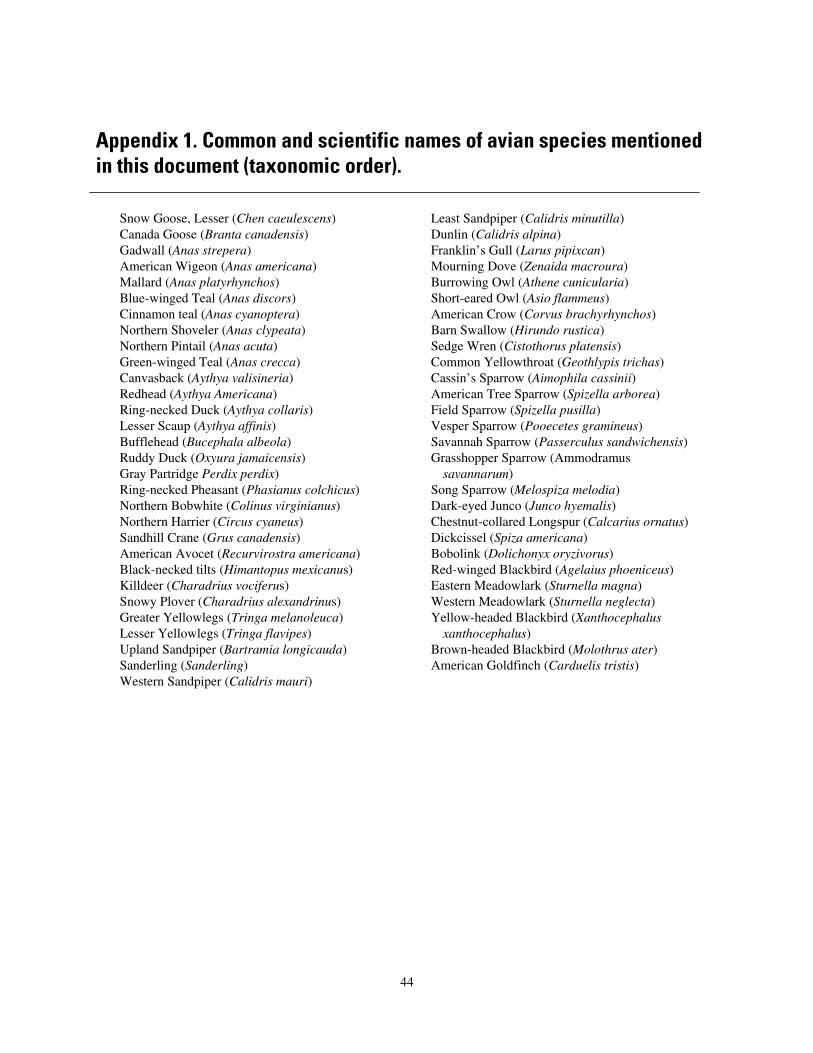
Appendix 1. Common and scientific names of avian species mentioned in this document (taxonomic order).
Snow Goose, Lesser (Chen caeulescens) Least Sandpiper (Calidris minutilla) Canada Goose (Branta canadensis) Dunlin (Calidris alpina) Gadwall (Anas strepera) Franklin’s Gull (Larus pipixcan) American Wigeon (Anas americana) Mourning Dove (Zenaida macroura) Mallard (Anas platyrhynchos) Burrowing Owl (Athene cunicularia) Blue-winged Teal (Anas discors) Short-eared Owl (Asio flammeus) Cinnamon teal (Anas cyanoptera) American Crow (Corvus brachyrhynchos) Northern Shoveler (Anas clypeata) Barn Swallow (Hirundo rustica) Northern Pintail (Anas acuta) Sedge Wren (Cistothorus platensis) Green-winged Teal (Anas crecca) Common Yellowthroat (Geothlypis trichas) Canvasback (Aythya valisineria) Cassin’s Sparrow (Aimophila cassinii) Redhead (Aythya Americana) American Tree Sparrow (Spizella arborea) Ring-necked Duck (Aythya collaris) Field Sparrow (Spizella pusilla) Lesser Scaup (Aythya affinis) Vesper Sparrow (Pooecetes gramineus) Bufflehead (Bucephala albeola) Savannah Sparrow (Passerculus sandwichensis) Ruddy Duck (Oxyura jamaicensis) Grasshopper Sparrow (Ammodramus Gray Partridge Perdix perdix) savannarum) Ring-necked Pheasant (Phasianus colchicus) Song Sparrow (Melospiza melodia) Northern Bobwhite (Colinus virginianus) Dark-eyed Junco (Junco hyemalis) Northern Harrier (Circus cyaneus) Chestnut-collared Longspur (Calcarius ornatus) Sandhill Crane (Grus canadensis) Dickcissel (Spiza americana) American Avocet (Recurvirostra americana) Bobolink (Dolichonyx oryzivorus) Black-necked tilts (Himantopus mexicanus) Red-winged Blackbird (Agelaius phoeniceus) Killdeer (Charadrius vociferus) Eastern Meadowlark (Sturnella magna) Snowy Plover (Charadrius alexandrinus) Western Meadowlark (Sturnella neglecta) Greater Yellowlegs (Tringa melanoleuca) Yellow-headed Blackbird (Xanthocephalus Lesser Yellowlegs (Tringa flavipes) xanthocephalus) Upland Sandpiper (Bartramia longicauda) Brown-headed Blackbird (Molothrus ater) Sanderling (Sanderling) American Goldfinch (Carduelis tristis) Western Sandpiper (Calidris mauri)
44
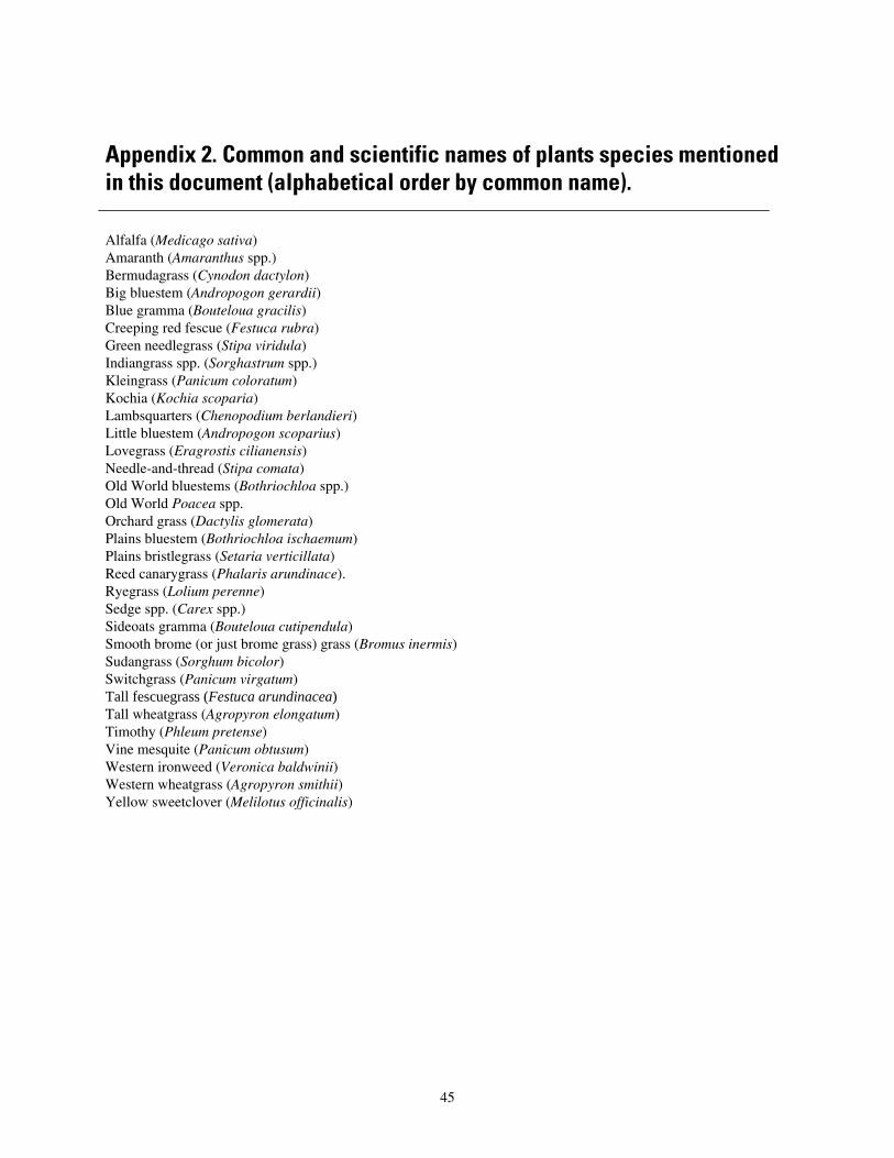
Appendix 2. Common and scientific names of plants species mentioned in this document (alphabetical order by common name).
Alfalfa (Medicago sativa) Amaranth (Amaranthus spp.) Bermudagrass (Cynodon dactylon) Big bluestem (Andropogon gerardii) Blue gramma (Bouteloua gracilis) Creeping red fescue (Festuca rubra) Green needlegrass (Stipa viridula) Indiangrass spp. (Sorghastrum spp.) Kleingrass (Panicum coloratum) Kochia (Kochia scoparia) Lambsquarters (Chenopodium berlandieri) Little bluestem (Andropogon scoparius) Lovegrass (Eragrostis cilianensis) Needle-and-thread (Stipa comata) Old World bluestems (Bothriochloa spp.) Old World Poacea spp. Orchard grass (Dactylis glomerata) Plains bluestem (Bothriochloa ischaemum) Plains bristlegrass (Setaria verticillata) Reed canarygrass (Phalaris arundinace). Ryegrass (Lolium perenne) Sedge spp. (Carex spp.) Sideoats gramma (Bouteloua cutipendula) Smooth brome (or just brome grass) grass (Bromus inermis) Sudangrass (Sorghum bicolor) Switchgrass (Panicum virgatum) Tall fescuegrass (Festuca arundinacea) Tall wheatgrass (Agropyron elongatum) Timothy (Phleum pretense) Vine mesquite (Panicum obtusum) Western ironweed (Veronica baldwinii) Western wheatgrass (Agropyron smithii) Yellow sweetclover (Melilotus officinalis)
45
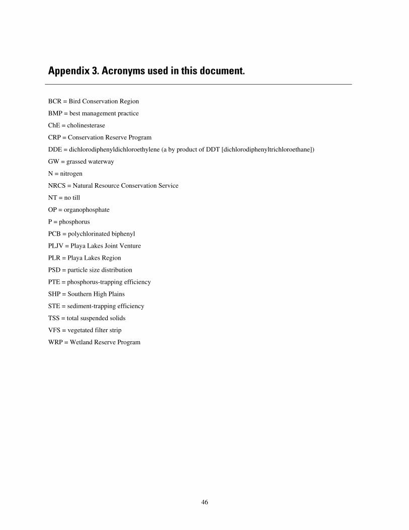
Appendix 3. Acronyms used in this document.
BCR = Bird Conservation Region
BMP = best management practice
ChE = cholinesterase
CRP = Conservation Reserve Program
DDE = dichlorodiphenyldichloroethylene (a by product of DDT [dichlorodiphenyltrichloroethane])
GW = grassed waterway
N = nitrogen
NRCS = Natural Resource Conservation Service
NT = no till
OP = organophosphate
P = phosphorus
PCB = polychlorinated biphenyl
PLJV = Playa Lakes Joint Venture
PLR = Playa Lakes Region
PSD = particle size distribution
PTE = phosphorus-trapping efficiency
SHP = Southern High Plains
STE = sediment-trapping efficiency
TSS = total suspended solids
VFS = vegetated filter strip
WRP = Wetland Reserve Program
46


![[Pgday.Seoul 2017] 3. PostgreSQL WAL Buffers, Clog Buffers Deep Dive - 이근오](https://img.pdfslide.net/doc/110x75/5a65da547f8b9aaf638b5143/pgdayseoul-2017-3-postgresql-wal-buffers-clog-buffers-deep-dive-.jpg)