Embed Size (px)
Citation preview
Grassy Mountain Project: November 13, 2014
1
DisclaimerForward Looking Statements
This presentation contains forward‐looking statements and factual information that are current as of the date the presentation was originally delivered. Calico Resources Corp. (the “Company”), formerly Cobre Exploration C di l i i t ti bli ti t d t i f d l ki t t t h thCorp. disclaims any intention or obligation to update or revise any forward‐looking statements, whether as a result of new information, future events or otherwise. Forward‐looking statements include, but not limited to, statements with respect to the timing and property acquisitions, amount of estimated future exploration, success of exploration activities, expenditures, permitting, and requirements for additional capital and access to data.Forward‐looking statements involve known and unknown risks, uncertainties and other factors which mayForward looking statements involve known and unknown risks, uncertainties and other factors which may cause the actual results, performance or achievements of the Company to be materially different from any future results, performance or achievements expressed or implied by the forward‐looking statements. Such factors include but not limited to, risks related to actual results of future exploration activities, change in project parameters as plans continue to be refined; the ability to enter joint ventures or acquire or dispose of properties; future prices of mineral resources; accidents, labor disputes and other risks of the mining industry; ability to obtain financing; and delays in obtaining governmental approvals of financingability to obtain financing; and delays in obtaining governmental approvals of financing. The information provided here is not an offer to sell securities or the solicitation of an offer to buy securities, nor will there be any sale of securities in any jurisdiction in which such offer, solicitation or sale would be unlawful prior to registration or qualification under the securities laws of such jurisdiction.
Qualified PersonQualified Person
Michael F. McGinnis, CPG, Project Manager‐Exploration for Calico Resources USA Corp., is the Qualified Person as defined in NI43‐101, and is responsible for verifying that the information presented in this document is an accurate representation of the October 2012 NI 43‐101 resource estimate for the Grassy Mountain Project.
www.CalicoResources.com TSXTSX‐‐V: CKBV: CKB 2
HighlightsGrassy Mountain Gold Project
• Calico Resources USA a wholly owned subsidiary of Calico Resources Corporation
• 100% Calico Resources USA ownership (subject to royalties)
• Prefeasibility Stage Project
y j
• Prefeasibility Stage Project
• Defined Resource, large low‐grade shell surrounding a high‐grade core of gold mineralization
• Calico intends to permit and develop a high‐grade underground mine at GrassyCalico intends to permit and develop a high grade underground mine at Grassy
• Conventional underground mining and ore processing techniques
• Preliminary Economic Assessment and Metallurgy Test Work completed Q1, 2015
• Permitting 18 to 24 mo., baseline studies finalized June to November, 2015Permitting 18 to 24 mo., baseline studies finalized June to November, 2015
• State and local regulatory officials have expressed support for developing the Grassy Mountain Gold Project
• Positive Economic Impact – 7 to12 mine life, 150 full time plus over 200 indirect jobsp , p j
• Located in a favorable jurisdiction with excellent infrastructure and available workforce
• No Adverse Environmental Impact
• Experienced management team
www.CalicoResources.com TSXTSX‐‐V: CKBV: CKB
p g
3
Rudi P. Fronk – Chairman/Director: Mr. Fronk has over 30 years experience in the gold business, primarily as a senior officer and director of
Management/ y p g , p y
publicly traded companies. From 1999 until June 2012, Mr. Fronk served as President and CEO of Seabridge Gold. Prior to Seabridge, he held senior management positions with Greenstone Resources, Columbia Resources, Behre Dolbear & Company, Riverside Associates, Phibro‐Salomon, Amax, and DRX. Mr. Fronk is a graduate of Columbia University from which he holds a Bachelor of Science in Mining Engineering and a Master of Science in Mineral Economics.
Paul Parisotto – President, CEO
Mr. Parisotto has been the Chairman and Director of Norant Resources Ltd. since 2008. Mr Parisotto has been responsible for all facets of the administration of this public nickel‐copper‐platinum‐palladium company. As President, CEO and Director of Arizona Star Resources Corp., listed on the TSX Venture Exchange and the American Stock Exchange, he led the sale of the company to Barrick Gold Corporation in December 2007 for $773 million in an all cash take‐over bid. Arizona Star owned a 51% interest in one of the world’s largest undeveloped gold/copper deposits. Earlier in his career, Paul built and headed up the mining corporate finance business for a Canadian investment dealer after serving as the Manager, Original Listing for the Toronto Stock Exchange.
Vance V. Thornsberry, P. Geo – Vice President of Exploration
Registered Professional Geologist with over 35 years of US and International experience in the mining and exploration industry. Mr. Thornsberry has held executive, managerial and technical roles for several companies. He has a strong technical background in both precious and base metals and his expertise ranges from exploration through production. He served as the VP Exploration for Northlands Resources from 2004 to 2008 where he was instrumental in the identification, acquisition and initial development of the Pajala Shear Zone IOCG properties in Sweden and Finland Licensed Professional Geologist in Washington and Wyomingproperties in Sweden and Finland. Licensed Professional Geologist in Washington and Wyoming.
Alec Peck‐ Chief Financial Officer
Mr. Peck completed his chartered accountant designation with Deloitte, Touche, Chartered Accountants – Vancouver. He then practiced in Alberta before moving to Toronto. From 1986 until 1993, he was a Partner in Toronto and then Vancouver with member offices of the international public accounting firm Horwath International. From 1993 until March 2004 he was a Vice President in the corporate finance group of publicly listed full service investment dealers, first with CM Oliver and then Canaccord Capital Corporation, which acquired C M g p p y p p qOliver.
Michael McGinnis, CPG, PG – Project Manager
Mr. McGinnis has 25+ years of experience that covers all aspects of exploration in senior positions with such companies as Placer Dome Inc., New Butte Mining, Union Mines Inc., and Kobex Colorado Corp. He has spent more than twelve years as a senior consultant for clients such as Agnico‐Eagle, Hecla, and Hunter Dickinson Inc. Mr. McGinnis is experienced in various styles of gold mineralization, including epithermal and C li t d it ll C A M h t k d l i i lfid H i t l t f th
www.CalicoResources.com TSXTSX‐‐V: CKBV: CKB
Carlin‐type deposits, as well as Cu‐Au‐Mo porphyry systems, skarns, and volcanogenic massive sulfides. He was an integral part of the discovery teams at Donlin Creek, Alaska; Campo Morado, Mexico and Kilgore, Idaho. Mr. McGinnis is a Certified Professional Geologist with AIPG, a licensed professional geologist in the State of Alaska and a QP in Canada.
4
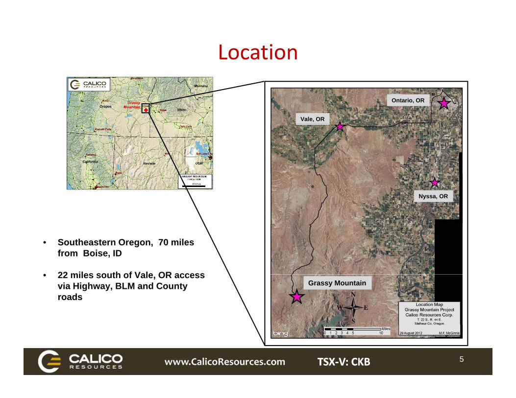
Location
Vale, OR
Ontario, OR
Nyssa, OR
• Southeastern Oregon, 70 miles from Boise, ID
• 22 miles south of Vale OR access• 22 miles south of Vale, OR access via Highway, BLM and County roads
Grassy Mountain
www.CalicoResources.com TSXTSX‐‐V: CKBV: CKB 5
History• 1984 ‐ Skip Yates & Dick Sherry
o Identified area based upon regional N.U.R.E. data
o Targeting epithermal hot spring gold
• Optioned to Newmont in Oct. 1992o 11 holes, 11,472 feeto Rock & soil sampling, regional recon,
detailed mapping, geophysics,occurrences
o Surface sample of 225 ppb Au in sinter outcrop to the west of the deposit
• Optioned to Atlas Precious Metals in 1986
permitting, pre‐feasibilityo Newmont relinquishes option in Aug., 1996
• Tombstone Exploration 1998o 10 holes, 8 RC, 2 Core totaling 8,067 feet
A i d b S b id i 2000o Drilled 1986 ‐ 1991o Discovery hole 26‐9: 145 feet @ 0.075 opt
Auo 388 holes, 221,500 feeto Resource announced in 1990 :
• Acquired by Seabridge in 2000• Acquired by Calico Resources in 2011• Total Drilling to date:
o 428 drill holes totaling 254,150 feet996,000 ounces Au
• Gold rush ensued in SE Oregon/SW Idaho
• 2012 Resource Estimateo 1.6 M oz Au Measured + Indicated
grading 1.13 g/t Au
• > $30 M invested historically
www.CalicoResources.com TSXTSX‐‐V: CKBV: CKB 6
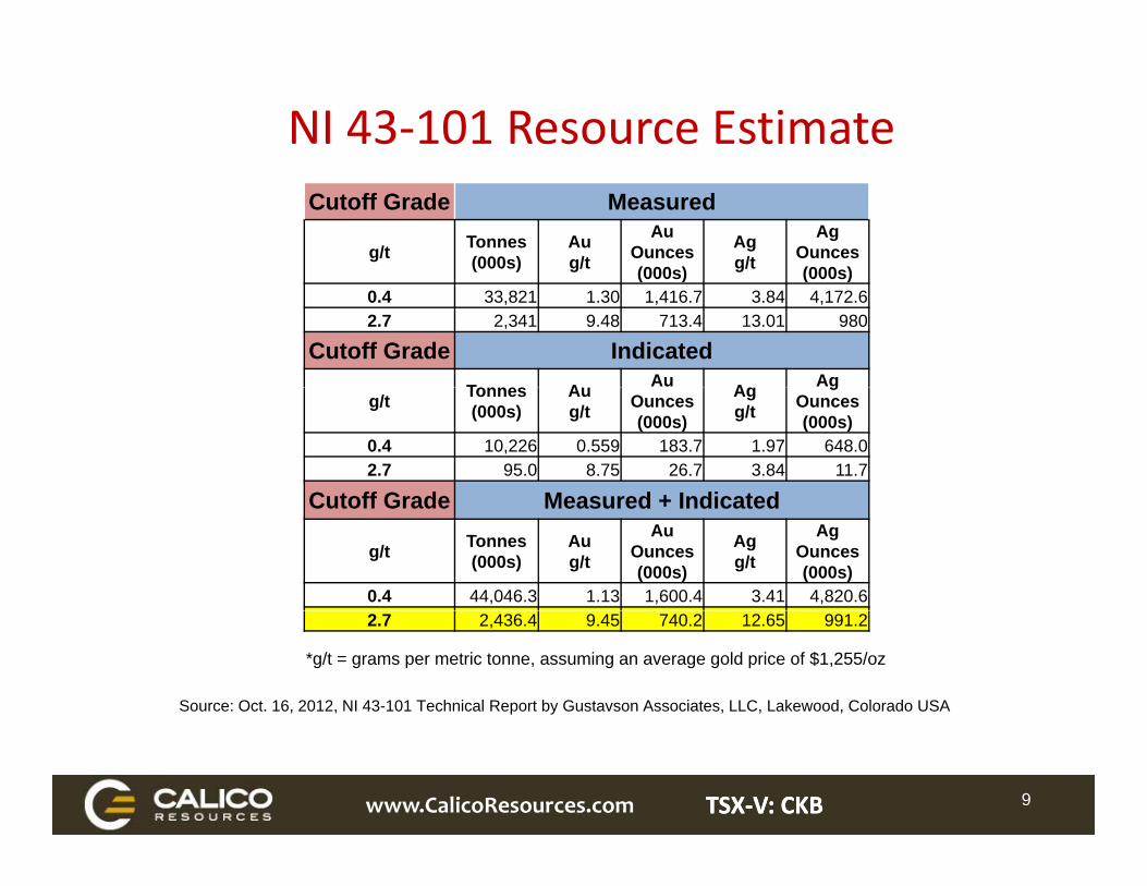
NI 43‐101 Resource EstimateCutoff Grade Measured
g/t Tonnes(000s)
Au g/t
Au Ounces(000s)
Ag g/t
Ag Ounces(000s)(000s) (000s)
0.4 33,821 1.30 1,416.7 3.84 4,172.6 2.7 2,341 9.48 713.4 13.01 980
Cutoff Grade IndicatedT A Au A Ag
g/t Tonnes(000s)
Au g/t Ounces
(000s)
Ag g/t
gOunces(000s)
0.4 10,226 0.559 183.7 1.97 648.02.7 95.0 8.75 26.7 3.84 11.7
Cutoff Grade Measured + IndicatedCutoff Grade Measured + Indicated
g/t Tonnes(000s)
Au g/t
Au Ounces(000s)
Ag g/t
Ag Ounces(000s)
0.4 44,046.3 1.13 1,600.4 3.41 4,820.6
*g/t = grams per metric tonne, assuming an average gold price of $1,255/oz
Source: Oct. 16, 2012, NI 43-101 Technical Report by Gustavson Associates, LLC, Lakewood, Colorado USA
2.7 2,436.4 9.45 740.2 12.65 991.2
www.CalicoResources.com TSXTSX‐‐V: CKBV: CKB 9
Calico Grassy Mountain Project• Limited footprint – Permit area 270 acres or 0.004% of Malheur County (6,355,000 acres)
• Mining and processing facilities will be on private land
• We expect to use off‐the‐shelf ore processing technology
• Underground resource, accessible by decline, amenable to conventional u/g mining methods
• Straight –forward Reclamation
• Favorable Environmental Settingo High desert environmento Moderate topographyo No perennial surface waterso No perennial surface waterso No Impacted wetlandso Outside critical wildlife habitat – NO SAGE GROUSEo Resource above the water tableo No restricted land use designations
• Good logistics / available infrastructure / local labor force
• Jobs and Enhanced Tax Base for Malheur County
www.CalicoResources.com TSXTSX‐‐V: CKBV: CKB 14
• Environmental baseline work plans approved in March 2013 Permitting Status – Current and Planned Tasks
(first proposal since 1990 to secure approvals in State of Oregon)
• Key environmental baseline studies and field work completedo Numerous tasks completed and submitted for approval:
• Uplands Vegetation & Wetlands• Wildlife Fish & AquaticsWildlife, Fish & Aquatics• Noise• Soils & Geology• Visual
o Ongoing tasks• Surface & ground water (final sampling in Q3, 2014)• Climate & Air Quality Geochemistry• Land use• Transportation
o Remaining tasks poised for ramp up in 2015
• Preliminary Economic Assessment underway (available Q1 2015)
• Detailed Metallurgical Test‐work (part of PEA)
• Submit BLM ROW Application (2015)• Submit BLM ROW Application (2015)
• Initiate work on Plan of Ops / State of Oregon Application (2015)o Federal, State & Local permits
I iti t t ti f d li f b lk t ti d f ibilit k
www.CalicoResources.com TSXTSX‐‐V: CKBV: CKB 15
• Initiate construction of decline access for bulk testing and feasibility work
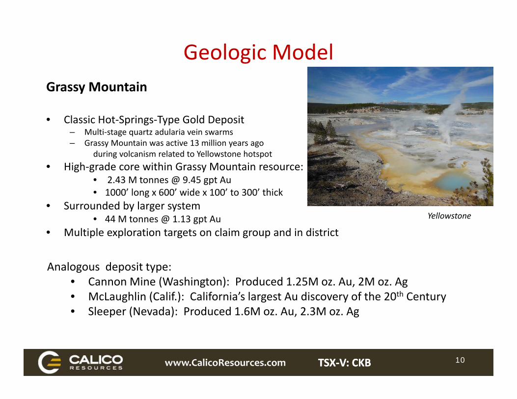
Geologic ModelGrassy Mountain
• Classic Hot‐Springs‐Type Gold Depositp g yp p– Multi‐stage quartz adularia vein swarms– Grassy Mountain was active 13 million years ago
during volcanism related to Yellowstone hotspot
• High‐grade core within Grassy Mountain resource: • 2.43 M tonnes @ 9.45 gpt Au• 1000’ long x 600’ wide x 100’ to 300’ thick
• Surrounded by larger system• 44 M tonnes @ 1.13 gpt Au Yellowstone
• Multiple exploration targets on claim group and in district
Analogous deposit type:• Cannon Mine (Washington): Produced 1.25M oz. Au, 2M oz. Ag• McLaughlin (Calif.): California’s largest Au discovery of the 20th Century• Sleeper (Nevada): Produced 1.6M oz. Au, 2.3M oz. Ag
www.CalicoResources.com TSXTSX‐‐V: CKBV: CKB 10
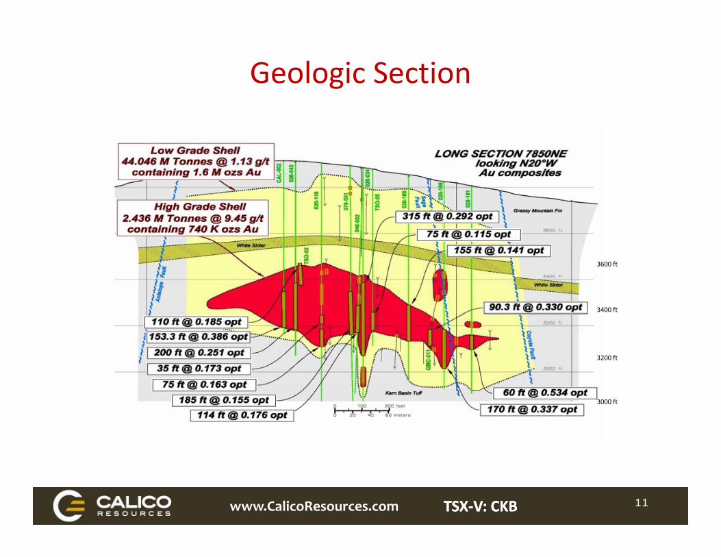
Geologic Section
3600 ft
3400 ft
3200 ft
3000 ft
www.CalicoResources.com TSXTSX‐‐V: CKBV: CKB 11
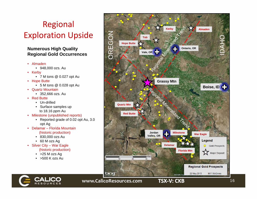
Kerby Almaden
T b OON
Regional Exploration Upside Tub
Hope Butte
Vale, OROntario, OR
IDA
HO
OR
EG
OExploration UpsideNumerous High Quality Regional Gold Occurrences
Boise IDGrassy Mtn
• Almaden• 948,000 ozs. Au
• Kerby• 7 M tons @ 0.027 opt Au
• Hope Butte • 5 M tons @ 0.028 opt Au Boise, ID
Quartz Mtn
@ p• Quartz Mountain
• 352,666 ozs. Au• Red Butte
• Un-drilled• Surface samples up
to 18.16 ppm Au
War EagleJordanValley, OR
Red Butteto 18.16 ppm Au
• Milestone (unpublished reports)• Reported grade of 0.02 opt Au, 3.0
opt Ag• Delamar – Florida Mountain
(historic production)• 830 000 ozs Au
Milestone
Oregon Idaho
Delamar
Florida Mtn
830,000 ozs Au• 60 M ozs Ag
• Silver City – War Eagle(historic production)
• >25 M ozs Ag• >500 K ozs Au
www.CalicoResources.com TSXTSX‐‐V: CKBV: CKB 16
Contact:Contact:
Calico Resources Corp.Suite 615 - 800 West Pender StreetVancouver, BC Canada V6C 2V6
Tel: 1 855.589.0400
TSXV CKBTSXV: CKB
www.calicoresources.com
www.CalicoResources.com TSXTSX‐‐V: CKBV: CKB 19
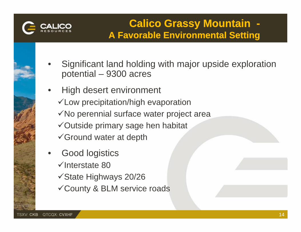
Calico Grassy Mountain Calico Grassy Mountain --A Favorable Environmental SettingA Favorable Environmental Setting
• Significant land holding with major upside exploration potential 9300 acrespotential – 9300 acres
• High desert environmentLow precipitation/high evaporationLow precipitation/high evaporationNo perennial surface water project areaOutside primary sage hen habitatGround water at depth
• Good logisticsInterstate 80State Highways 20/26County & BLM service roadsCounty & BLM service roads
14
Malheur County Malheur County Socioeconomic SettingSocioeconomic Setting
• Local cities and labor force – Vale, Ontario, Nyssa and BoiseBoise
• Unemployment – as high as 12.8% (currently 8.6%)
• Construction workforce 200• Construction workforce – 200
• Operations workforce – 150
E ti t d i di t j b i th i 211• Estimated indirect jobs in the region - 211
• Est. annual payroll cost $13.2 million ($88,000/employee)
• Annual operating cost about $50 million
• Large economic impact – labor dollars turn 5-8 times
15
History of History of Team’s Involvement Team’s Involvement Calico/State of OregonCalico/State of Oregon
• Initially part of 1990 Cooperative rule-making with state and federal agencies and NGO’sg
• Worked directly on Grassy Mountain permitting and governmental and public affairs since 2011
• Guided development and approval NOI, all environmental baseline work plans and ROW application
W k d l l i h TRT d PCC d j• Worked closely with TRT and PCC to advance project
• Developed approved baseline study work plans
• Maintained solid working/professional relationship with NGO’s
16
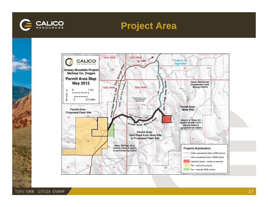
Project Project AreaArea
17

Calico Resources’ Grassy Mountain Calico Resources’ Grassy Mountain Project Project SettingSetting
• 9,300 Acres of Contiguous Controlled Ground 418 unpatented lode claims, 3 patented lode claims, 9 ill it l i 6 i ti l l i 9 mill site claims, 6 association placer claims
• Underground Mining approx. 1000-1200 TPD using conventional cut & fillconventional cut & fill
• Easy Access via 3.5 mile, 60 ft. wide haul road and existing County/BLM access
• Simple and proven processing plan gravity separation, flotation and/or cyanide vat leach
of concentrate
• Tailings disposal dry stack on private fee land
• Straight- forward reclamation by conventional best engineering practices
18
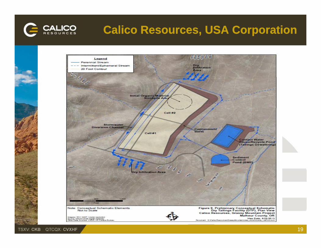
Calico Calico Resources, USA CorporationResources, USA Corporation
19
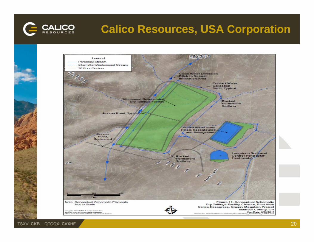
Calico Calico Resources, USA CorporationResources, USA Corporation
20
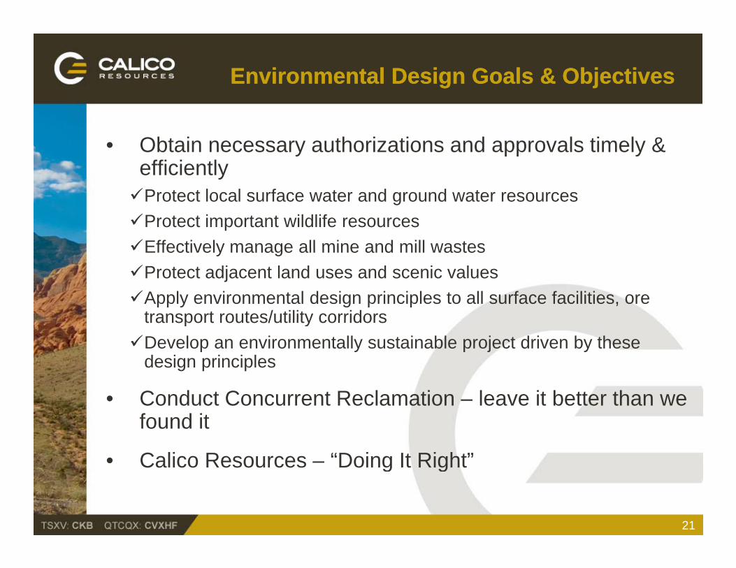
Environmental Design Goals & ObjectivesEnvironmental Design Goals & Objectives
• Obtain necessary authorizations and approvals timely & efficientlyyProtect local surface water and ground water resourcesProtect important wildlife resourcesEffectively manage all mine and mill wastesEffectively manage all mine and mill wastesProtect adjacent land uses and scenic valuesApply environmental design principles to all surface facilities, ore
transport routes/utility corridorstransport routes/utility corridorsDevelop an environmentally sustainable project driven by these
design principles
C d t C t R l ti l it b tt th• Conduct Concurrent Reclamation – leave it better than we found it
• Calico Resources – “Doing It Right”Calico Resources Doing It Right
21

Environmental Design “Template”Environmental Design “Template”For Grassy MountainFor Grassy Mountain
• Coeur Thunder Mountain Project9 major national & state environmental awards9 major national & state environmental awardsNo exceedances during operationsFinal closure and bond release by USFS/IDL
• Golden Cross Gold MineA sustainable project Forestry & grazing businessesForestry & grazing businessesEducation (U of Auckland Research Center)Ongoing advanced water treatment, reclamation trust
• Kensington Gold MineA partnership with the local Native Community Jobs, training, and preferential contractingg p gEnhanced wetlands
22
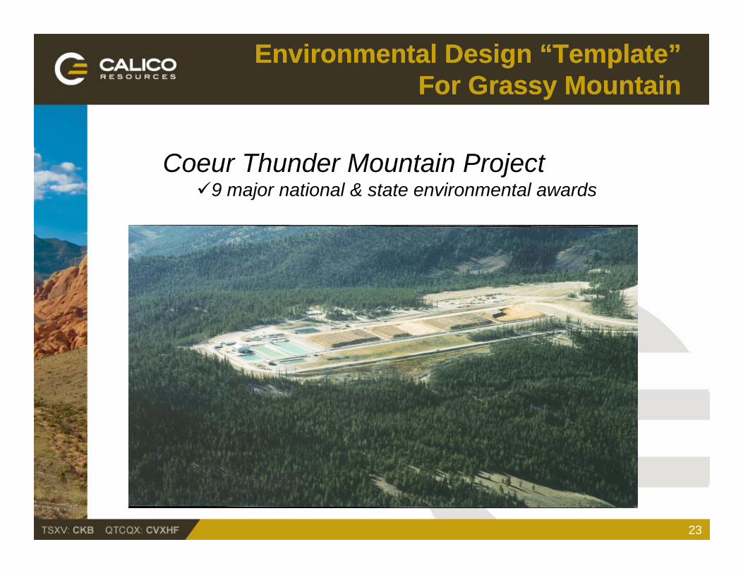
Environmental Design “Template”Environmental Design “Template”For Grassy MountainFor Grassy Mountain
Coeur Thunder Mountain Project9 major national & state environmental awards
23
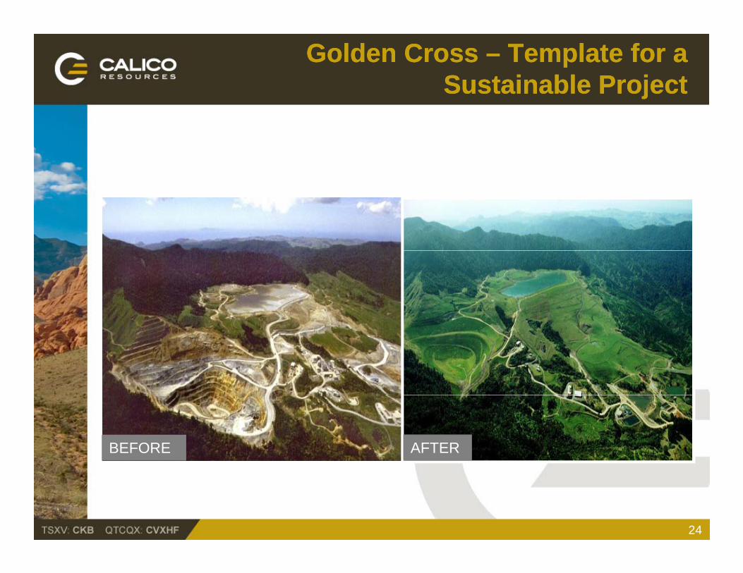
Golden Cross Golden Cross –– Template for a Template for a Sustainable Sustainable ProjectProject
BEFORE AFTER
24
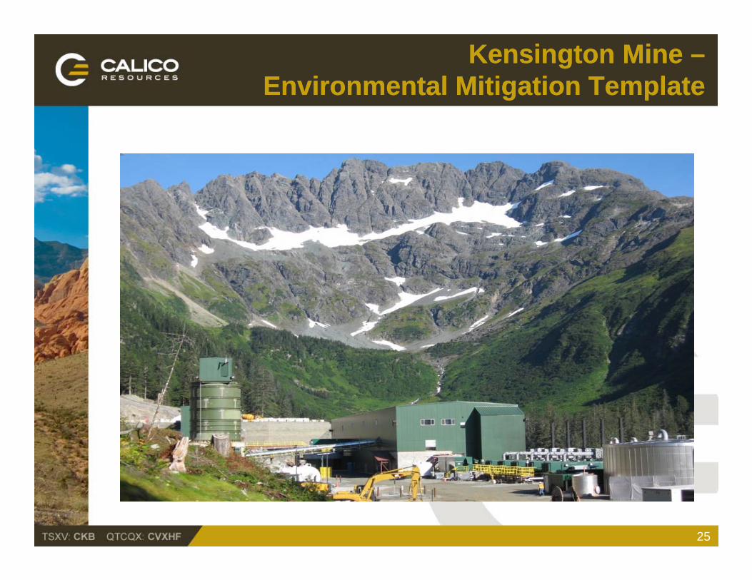
Kensington Mine Kensington Mine ––Environmental Mitigation TemplateEnvironmental Mitigation Template
25
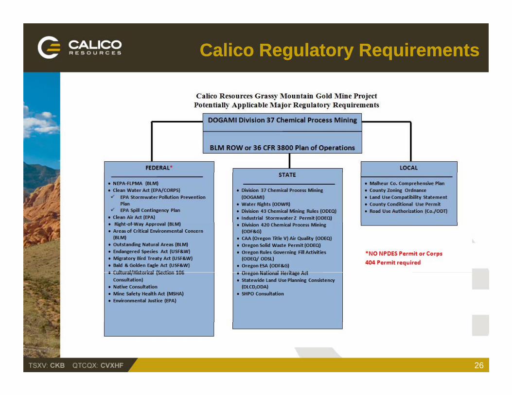
Calico Regulatory RequirementsCalico Regulatory Requirements
26
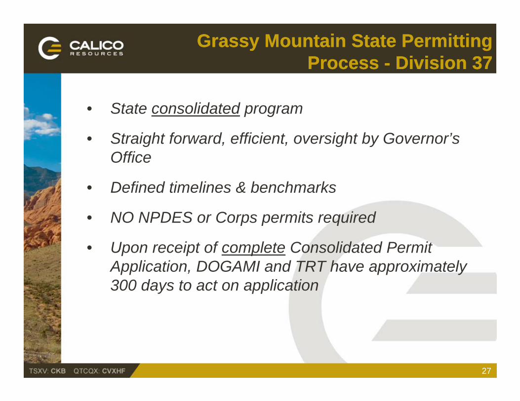
Grassy Grassy Mountain Mountain State Permitting State Permitting Process Process -- Division 37Division 37
• State consolidated program
• Straight forward, efficient, oversight by Governor’s Office
• Defined timelines & benchmarks
• NO NPDES or Corps permits required
• Upon receipt of complete Consolidated Permit Application, DOGAMI and TRT have approximately 300 days to act on application
27
Calico Grassy Mountain ProjectCalico Grassy Mountain Project
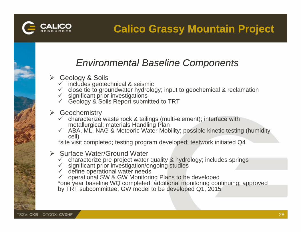
Environmental Baseline ComponentsEnvironmental Baseline Components Geology & Soils includes geotechnical & seismic close tie to groundwater hydrology; input to geochemical & reclamation significant prior investigations Geology & Soils Report submitted to TRT Geology & Soils Report submitted to TRT
Geochemistry characterize waste rock & tailings (multi-element); interface with
metallurgical; materials Handling Plan ABA ML NAG & Meteoric Water Mobility; possible kinetic testing (humidity ABA, ML, NAG & Meteoric Water Mobility; possible kinetic testing (humidity
cell)*site visit completed; testing program developed; testwork initiated Q4
Surface Water/Ground Water characterize pre-project water quality & hydrology; includes springs characterize pre-project water quality & hydrology; includes springs significant prior investigation/ongoing studies define operational water needs operational SW & GW Monitoring Plans to be developed*one year baseline WQ completed; additional monitoring continuing; approved by TRT subcommittee; GW model to be developed Q1 2015by TRT subcommittee; GW model to be developed Q1, 2015
28
Calico Grassy Mountain ProjectCalico Grassy Mountain Project
Environmental Baseline Components (Cont.)Environmental Baseline Components (Cont.)
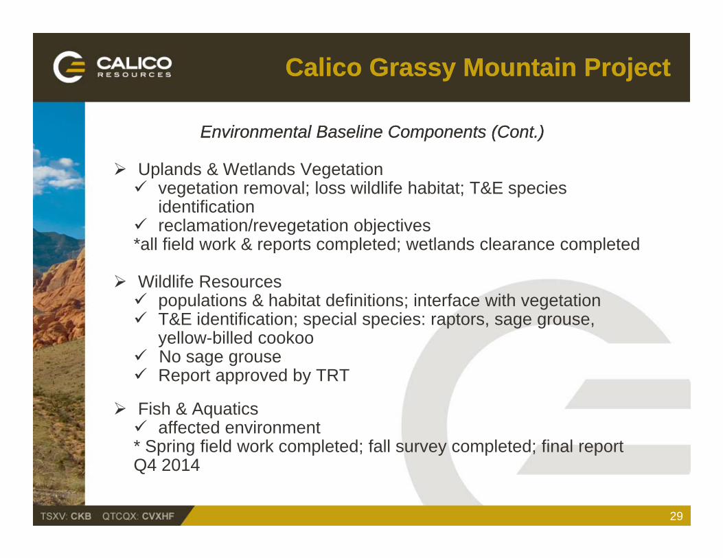
Uplands & Wetlands Vegetation Uplands & Wetlands Vegetation vegetation removal; loss wildlife habitat; T&E species
identification reclamation/revegetation objectives*all field work & reports completed; wetlands clearance completedall field work & reports completed; wetlands clearance completed
Wildlife Resources populations & habitat definitions; interface with vegetation T&E id tifi ti i l i t T&E identification; special species: raptors, sage grouse,
yellow-billed cookoo No sage grouse Report approved by TRT
Fish & Aquatics affected environment* Spring field work completed; fall survey completed; final report p g p y p pQ4 2014
29
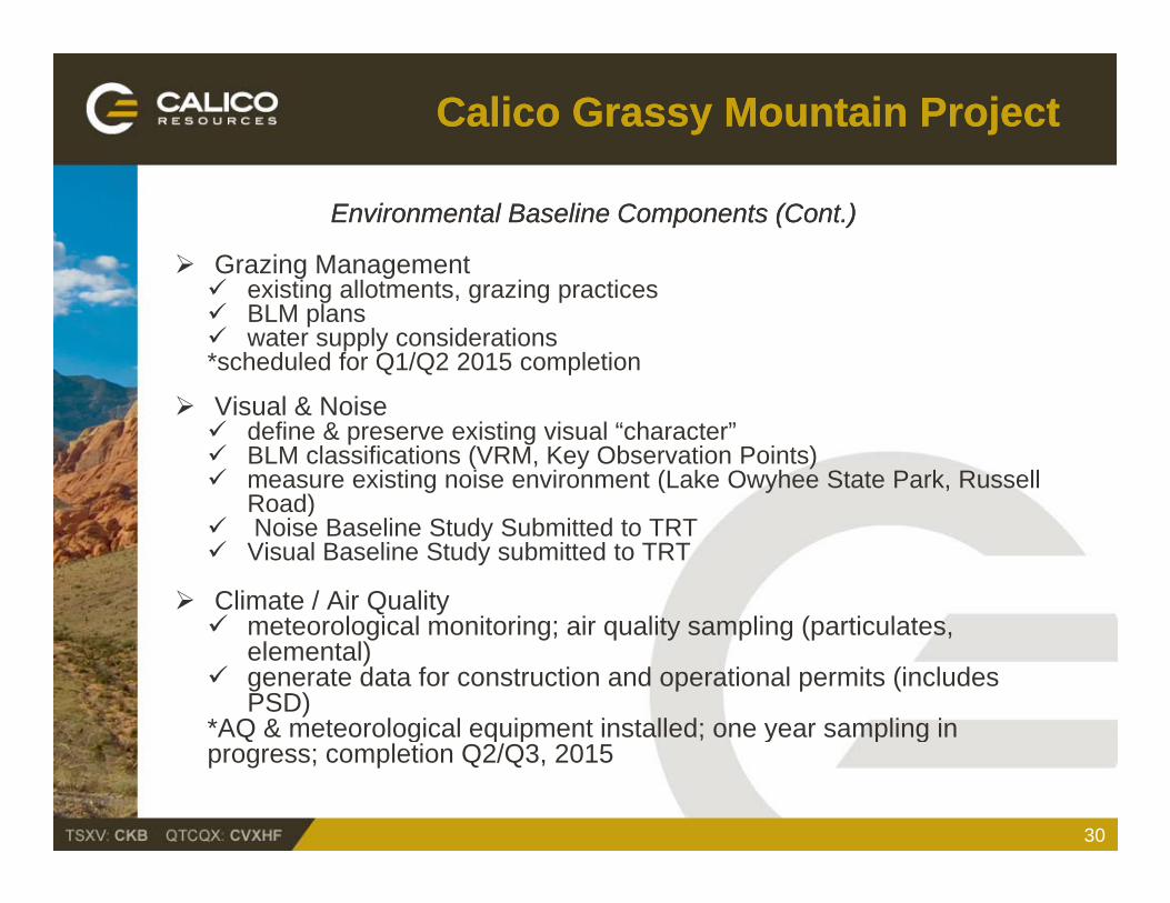
Calico Grassy Mountain ProjectCalico Grassy Mountain Project
Environmental Baseline Components (Cont.)Environmental Baseline Components (Cont.)
Grazing Management i ti ll t t i ti existing allotments, grazing practices BLM plans water supply considerations*scheduled for Q1/Q2 2015 completion
Visual & Noise define & preserve existing visual “character” BLM classifications (VRM, Key Observation Points) measure existing noise environment (Lake Owyhee State Park, Russell
Road)Road) Noise Baseline Study Submitted to TRT Visual Baseline Study submitted to TRT
Climate / Air Quality meteorological monitoring; air quality sampling (particulates meteorological monitoring; air quality sampling (particulates,
elemental) generate data for construction and operational permits (includes
PSD)*AQ & meteorological equipment installed; one year sampling inAQ & meteorological equipment installed; one year sampling in progress; completion Q2/Q3, 2015
30
Calico Grassy Mountain ProjectCalico Grassy Mountain Project
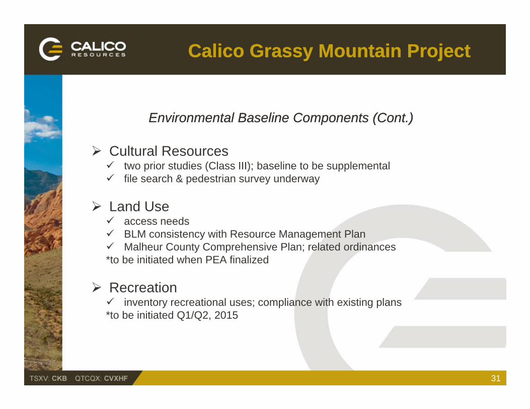
Environmental Baseline Components (Cont.)Environmental Baseline Components (Cont.)
Cultural Resources two prior studies (Class III); baseline to be supplemental file search & pedestrian survey underway file search & pedestrian survey underway
Land Use access needs BLM i t ith R M t Pl BLM consistency with Resource Management Plan Malheur County Comprehensive Plan; related ordinances*to be initiated when PEA finalized
Recreation inventory recreational uses; compliance with existing plans*to be initiated Q1/Q2, 2015
31
Calico Grassy Mountain ProjectCalico Grassy Mountain Project
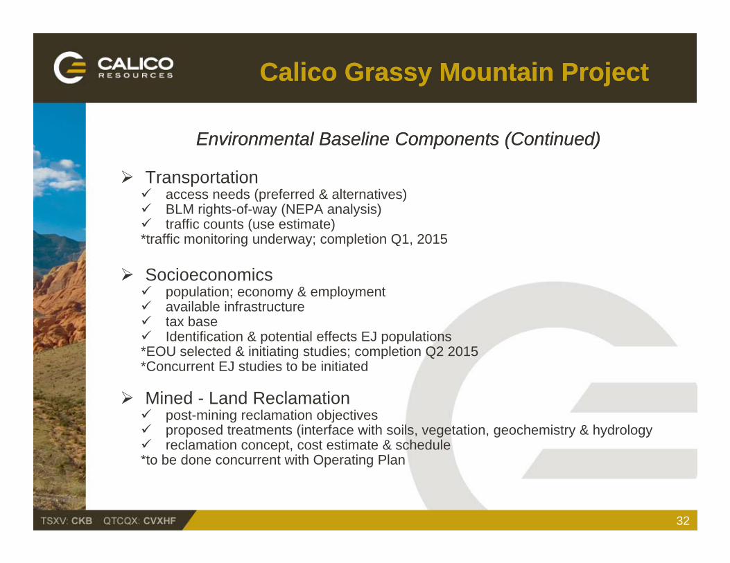
Environmental Baseline Components (Continued)Environmental Baseline Components (Continued)
Transportation Transportation access needs (preferred & alternatives) BLM rights-of-way (NEPA analysis) traffic counts (use estimate)*traffic monitoring underway; completion Q1, 2015g y p
Socioeconomics population; economy & employment available infrastructure t b tax base Identification & potential effects EJ populations*EOU selected & initiating studies; completion Q2 2015*Concurrent EJ studies to be initiated
Mined - Land Reclamation post-mining reclamation objectives proposed treatments (interface with soils, vegetation, geochemistry & hydrology reclamation concept, cost estimate & schedule*to be done concurrent with Operating Planto be done concurrent with Operating Plan
32
Calico Grassy Mountain ProjectCalico Grassy Mountain Project
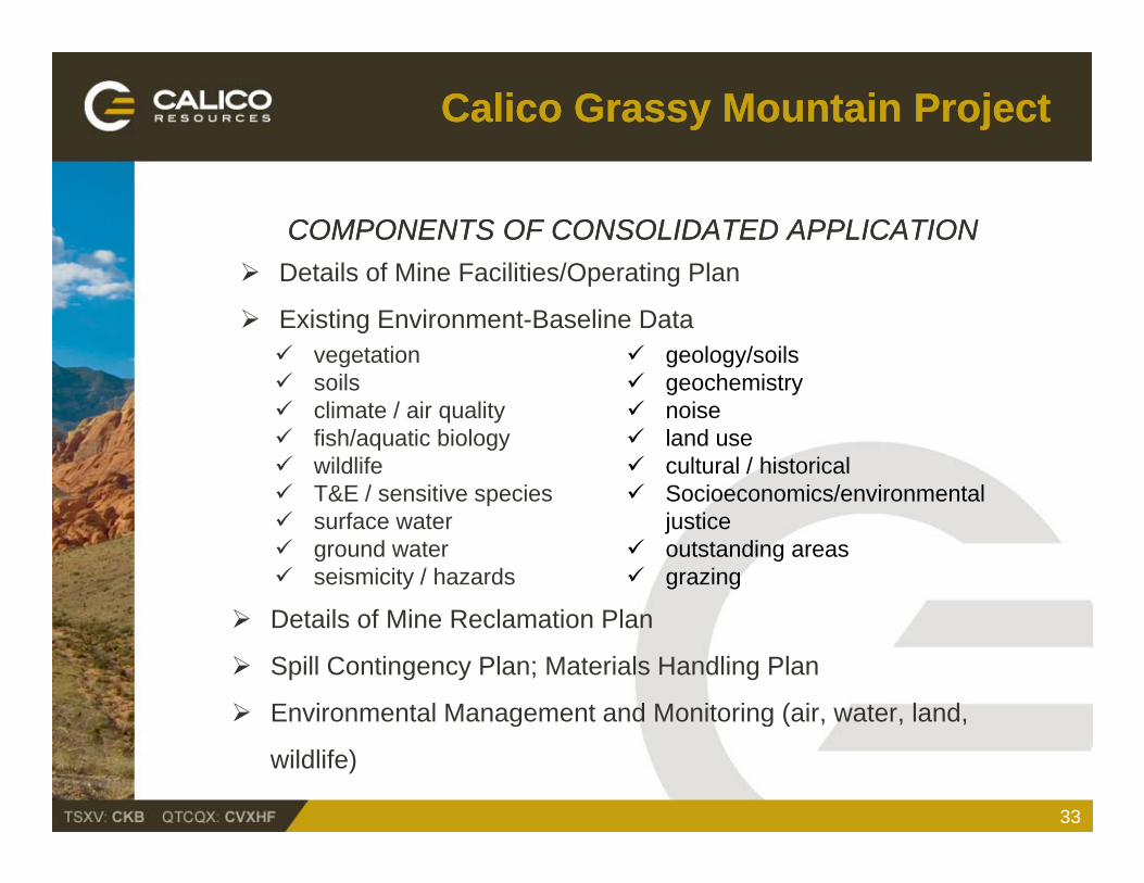
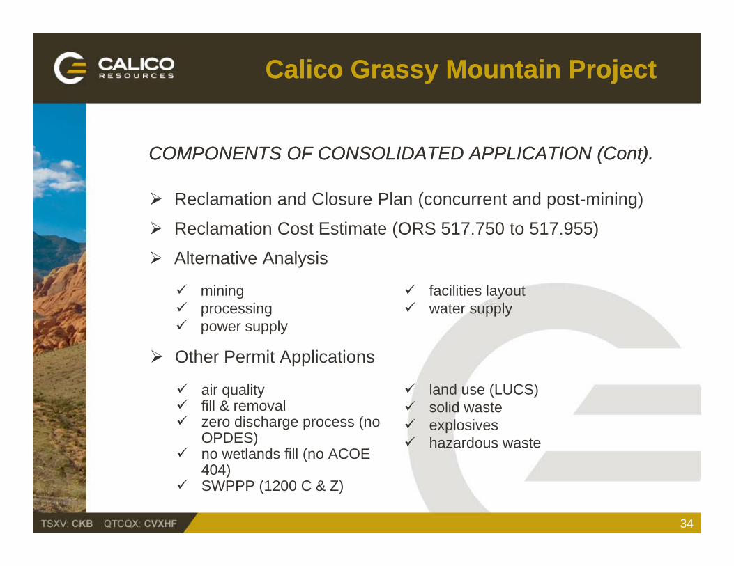
COMPONENTS OF CONSOLIDATED APPLICATIONCOMPONENTS OF CONSOLIDATED APPLICATION Details of Mine Facilities/Operating Plan
vegetation soils
Details of Mine Facilities/Operating Plan
Existing Environment-Baseline Data geology/soils geochemistry soils
climate / air quality fish/aquatic biology wildlife T&E / sensitive species
geochemistry noise land use cultural / historical Socioeconomics/environmental T&E / sensitive species
surface water ground water seismicity / hazards
Socioeconomics/environmental justice
outstanding areas grazing
Details of Mine Reclamation Plan
Spill Contingency Plan; Materials Handling Plan
Environmental Management and Monitoring (air, water, land,
33
Environmental Management and Monitoring (air, water, land,
wildlife)
Calico Grassy Mountain ProjectCalico Grassy Mountain Project
COMPONENTS OF CONSOLIDATED APPLICATION (COMPONENTS OF CONSOLIDATED APPLICATION (ContCont).).
Reclamation and Closure Plan (concurrent and post-mining)
Reclamation Cost Estimate (ORS 517.750 to 517.955)
mining processing
Alternative Analysis
facilities layout water supply
power supply
Other Permit Applications
air quality land use (LUCS) air quality fill & removal zero discharge process (no
OPDES) no wetlands fill (no ACOE
land use (LUCS) solid waste explosives hazardous waste
34
(404)
SWPPP (1200 C & Z)
Calico Grassy Mountain ProjectCalico Grassy Mountain Project
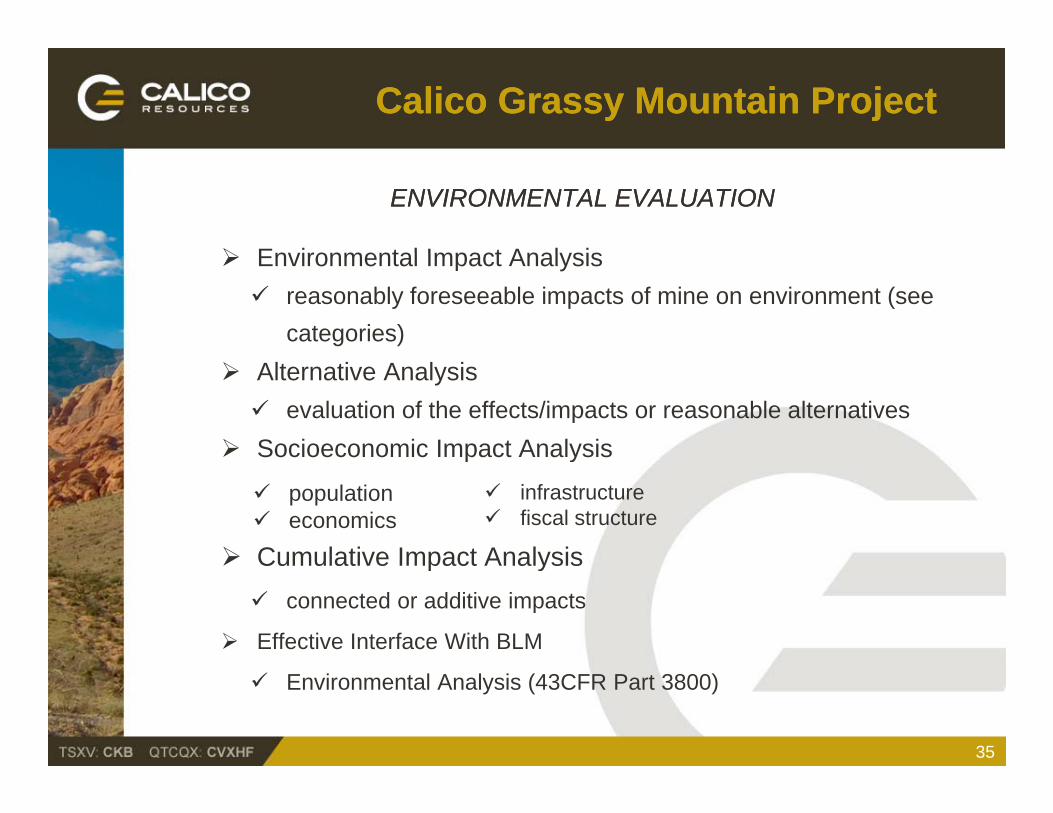
ENVIRONMENTAL EVALUATIONENVIRONMENTAL EVALUATION
En ironmental Impact Anal sis Environmental Impact Analysis reasonably foreseeable impacts of mine on environment (see
categories) Alternative Analysis evaluation of the effects/impacts or reasonable alternatives
Socioeconomic Impact Analysisp y
Cumulative Impact Analysis
population economics
infrastructure fiscal structure
Cumulative Impact Analysis connected or additive impacts
Effective Interface With BLM
35
Environmental Analysis (43CFR Part 3800)
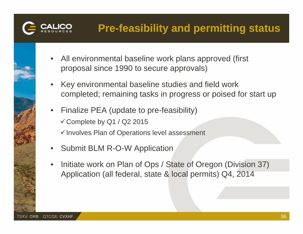
PrePre--feasibility feasibility and and permitting statuspermitting status
• All environmental baseline work plans approved (first proposal since 1990 to secure approvals)
• Key environmental baseline studies and field work completed; remaining tasks in progress or poised for start up
• Finalize PEA (update to pre-feasibility)Complete by Q1 / Q2 2015 Involves Plan of Operations level assessment Involves Plan of Operations level assessment
• Submit BLM R-O-W Application
I i i k Pl f O / S f O (Di i i 3 )• Initiate work on Plan of Ops / State of Oregon (Division 37) Application (all federal, state & local permits) Q4, 2014
36
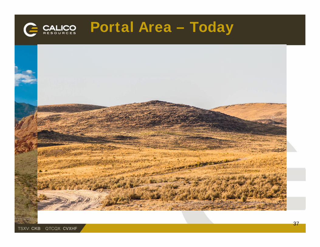
Portal Area – Today
37
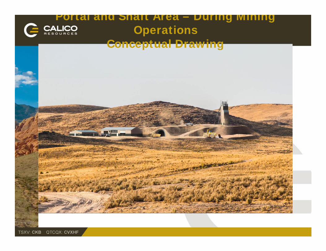
Portal and Shaft Area – During Mining Operations
Conceptual DrawingConceptual Drawing
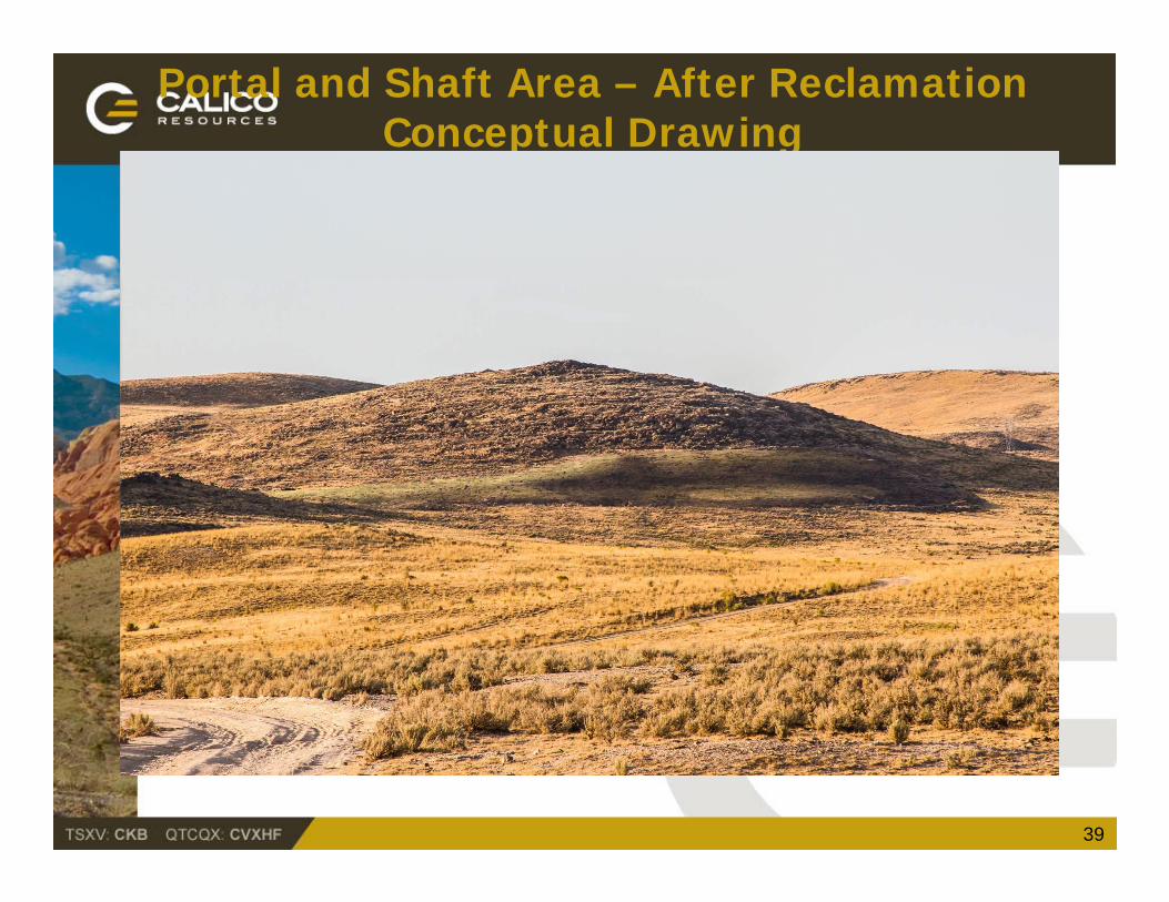
Portal and Shaft Area – After ReclamationConceptual Drawing
39
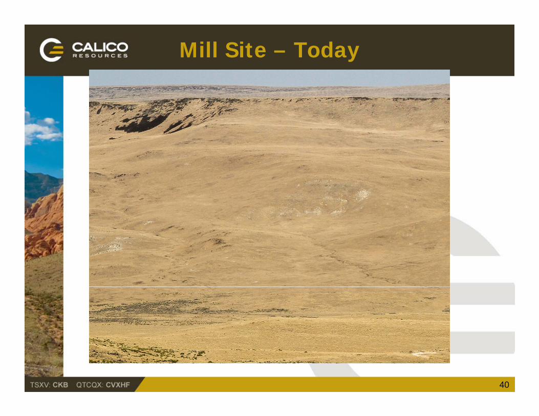
Mill Site – Today
40
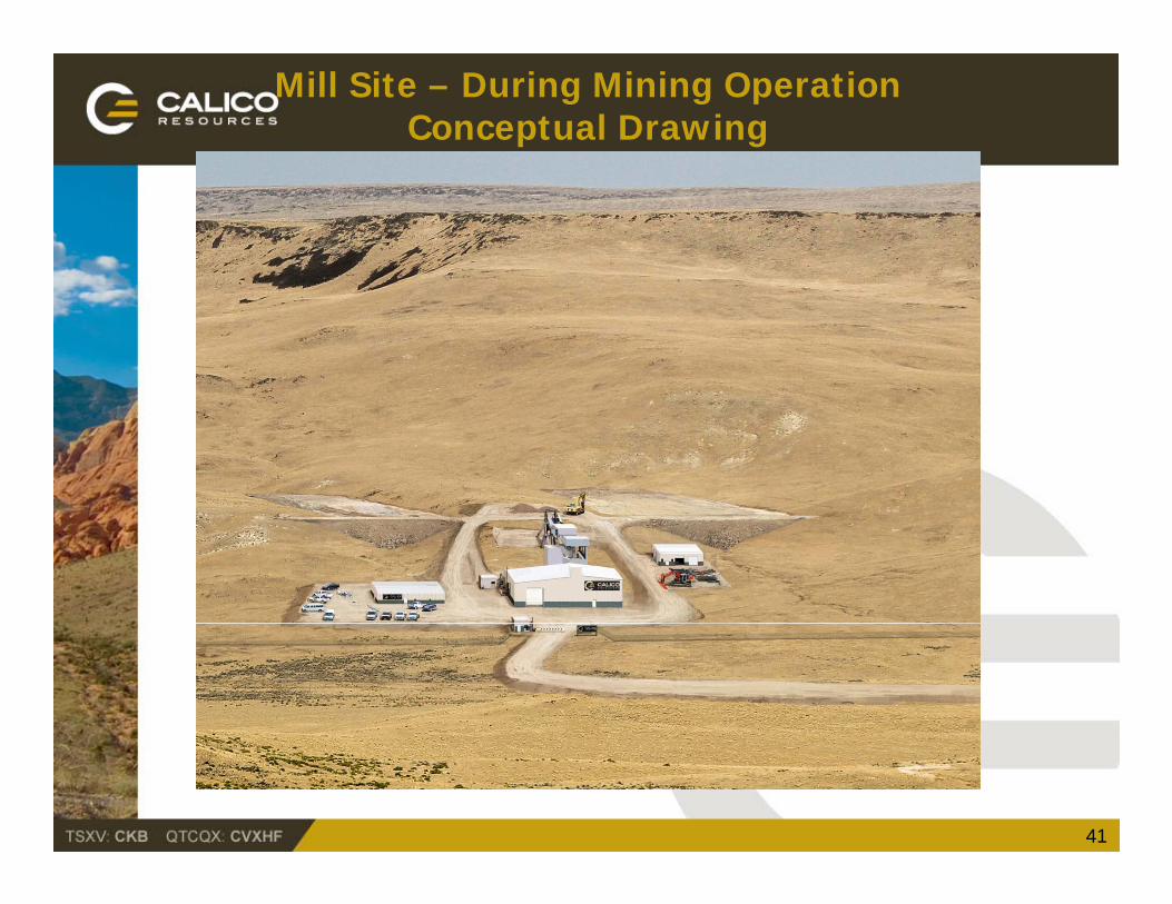
Mill Site – During Mining OperationConceptual Drawing
41
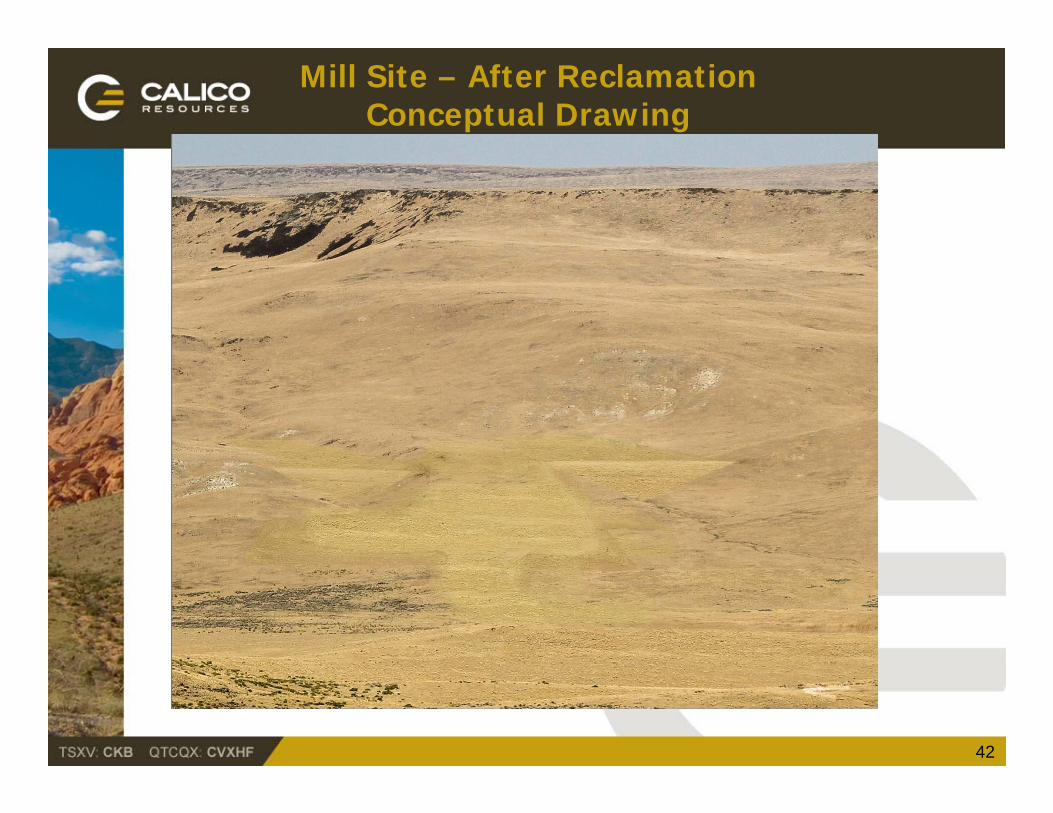
Mill Site – After ReclamationConceptual Drawing
42