Embed Size (px)
Citation preview

Greater Los Angeles Integrated Regional Water Management Plan Meeting Notes – Upper Los Angeles River Watersheds Steering Committee
The mission of the Greater Los Angeles IRWMP is to address the water resources needs of the Region in an integrated and collaborative manner.
Draft Meeting and Project Prioritization Workshop Minutes January 27, 2009, 10:30 am to 3:30 pm
Glendale Water and Power, Perkins Community Room 118 Present:
Siya Araumi, LA County FCD Debbie Bruschaber, MRT Bekah Cooke, San Gabriel Valley COG George De La O, LA County FCD Joyce Dillard Rebecca Drayse, TreePeople Tom Erb, LADWP
Darryl Ford, City of LA Rec and Parks Richard Gomez, LA County DPW Mark Hanna, LADWP Andree Hunt, Malcolm Pirnie Morton Khaim, Office of Sen. Alex Padilla Michael LaRussa, City of Calabasas Vivian Marquez, City of LA Sanitation
Ed Means, Malcolm Pirnie Andy Niknafs, LADWP Daniel Pankali, City of Calabasas Nancy Steele, LASGRWC Patricia Wood, LA County DPW
Topic/Issue Discussion Action/Follow up
1. Introductions Tom Erb opened the meeting with introductions. • No Action
2. Approve 11/19/08 Meeting Minutes
The meeting minutes were approved with changes.
Tom Erb provided an update on Prop 84 guidelines. The State has said that the guidelines will be released this spring, but they could be deferred.
• Consultant will update 11/19/08 meeting minutes to reflect adopted changes.
3. DAC Outreach Update The consultant met with a set of stakeholders on each project in order to see if the projects could be developed to be competitive within timeframe. The project handouts were distributed, and Ed Means gave a presentation on each project.
Comments on the Arroyo Seco confluence project included:
• In order for the LA River to maintain Clean Water Act status, commerce on the river will need to be addressed. The project description for the Arroyo Seco confluence project should state that there is a related issue with the LA River and navigability.
• This project needs to be added to the database.
Comments on the Hansen Dam Walnut Woodlands Restoration project
• The consultant will send the project handouts to meeting invitees to obtain their input and will put together a concept implementation report for what would need to be done to move each project forward.

Meeting Notes – Upper Los Angeles River Watersheds Steering Committee – January 27, 2009 Page 2 of 5
The mission of the Greater Los Angeles IRWMP is to address the water resources needs of the Region in an integrated and collaborative manner.
Topic/Issue Discussion Action/Follow up
included:
• The Army Corps has a 1999 study regarding water supply benefits of the Hansen Dam project.
• Parks and Recreation leases this land from Army Corps. There is a Hansen Dam Master Plan that was developed by Parks and the Army Corps from 1991/92.
Other comments included:
• Some projects made it to the stimulus proposal (sponsored by Villaraigosa through his lobbyist Jim Clark) that may not be in the IRWMP database
The Region could get $1-2M of DAC funds optimistically. This funding would probably be used for feasibility studies but could be used for implementation.
4. Review Project Scoring The consultant provided an overview of prioritization process. The goal of the prioritization process is to identify a few top projects that are ready to proceed to take to the LC in the March/April timeframe. There is a large window of uncertainty with the State, but the Region would like to be prepared when funding becomes available.
If the Region receives the maximum amount of money it is eligible for and this money is divided equally between the sub-regions, each sub-region will receive $4-5M. The SC will need to determine how much money should go to each project. Non-Capital projects are not applicable to Prop 84 IRWMP funding, except for DAC funds. Readiness to proceed will need to be a key consideration in the prioritization process. Selected projects will need to be sufficiently developed for a grant application in Summer 2009.
Discussion included:
• The Region needs to discuss the definition of “conservation” going forward. LADWP defines conservation as demand-side reduction. The LA County
• No Action

Meeting Notes – Upper Los Angeles River Watersheds Steering Committee – January 27, 2009 Page 3 of 5
The mission of the Greater Los Angeles IRWMP is to address the water resources needs of the Region in an integrated and collaborative manner.
Topic/Issue Discussion Action/Follow up
FCD defines conservation as the capture of water that would otherwise be lost.
• Projects with multiple benefits tend to rise to top.
• Columns with matching funds and project cost should be added to the project list.
• Rather than changing the weighting for different categories of prioritization, the consultant should sort out those projects that qualify in a particular category.
• The SC should determine whether any projects were updated following the integration exercise.
• For the first round of Prop 84 funding, DAC projects are being selected from top down process due to time.
• Land acquisition projects are probably not allowed under Prop 84.
5. Project Presentations The spreadsheet of prioritization projects was distributed, and proponents of the top 50 projects were asked to give brief presentations addressing project cost and readiness to proceed. The updated project spreadsheet and project descriptions will be distributed to the SC.
The consultant will draft an e-mail inviting the project proponents that were not present at the workshop to give presentations at the February SC meeting. The proponents will be asked to address readiness to proceed, project cost, and matching funds.
• The consultant will draft an e-mail inviting project proponents to present at the February SC meeting.
6. Regional Acceptance The State is requiring a regional acceptance process is order for each region to qualify as an IRWMP region. A formal delineation of what is required is expected within two weeks, and once this is received the Region will need to put together a submittal within 30 days. DWR will have interviews within 8 days of the receipt of the application. The purpose of this process is to minimize the number of discreet IRWMPs
• No Action

Meeting Notes – Upper Los Angeles River Watersheds Steering Committee – January 27, 2009 Page 4 of 5
The mission of the Greater Los Angeles IRWMP is to address the water resources needs of the Region in an integrated and collaborative manner.
Topic/Issue Discussion Action/Follow up
seeking funding. The Region submitted comments to DWR that the acceptance process should be simplified for established Regions that have already received funding.
DWR is considering having Prop 84 planning and implementation grants available concurrently.
7. Leadership Committee-Discuss Draft Agenda Items and Provide Direction to Chair
The LC will be discussing how much funding to apply for in Round 1 and how the funding should be split between the SCs. Discussion included:
• Having money split equally b/t sub-regions wouldn’t look favorable for the Region and wouldn’t take into account DACs. A region-wide filter of the projects put forward by each SC may be needed to make sure the Region’s projects are consistent with the overall goals of the IRWMP.
• Decision-making should not be taken away from the sub-regions.
• Setting a financial allocation for each sub-region is not in the spirit of identifying the best projects for the Region.
Regarding whether the SC should have strict control over project selection, the consensus of the SC was that funding should go to the best projects in the Region. The LC could make a recommendation on project selection, and the decision could then go back to the SCs for approval. Nancy Steele will advocate this at the LC.
The Region gave a proposal to Annenberg Foundation a year ago. The Foundation turned down the proposal but said they will consider an alternate proposal for grassroots DAC outreach.
The SC discussed making a recommendation to the LC to draft a letter to the Governor regarding “freeze of funds” for IRWM projects.
• Nancy Steele will advocate that funding should go to the best projects in the Region at the LC meeting.
8. Next Meetings The next Leadership Committee meeting will be January 28, 2009 at 9:30 am, at LACFCD, 12th floor.
• No Action

Meeting Notes – Upper Los Angeles River Watersheds Steering Committee – January 27, 2009 Page 5 of 5
The mission of the Greater Los Angeles IRWMP is to address the water resources needs of the Region in an integrated and collaborative manner.
Topic/Issue Discussion Action/Follow up
The SC meeting schedule is as follows:
• February 24, 2009 from 1:30 pm to 3:30 pm at LADWP.
• March 24, 2009 from 1:30 pm to 3:30 pm at LADWP.
• April 21, 2009 from 1:30 pm to 3:30 pm at LADWP.

Draft IRWM Regional Acceptance Process Guidelines For 30-Day Public Comment Starting December 22, 2008
Page 1 of 12
RREEGGIIOONN AACCCCEEPPTTAANNCCEE PPRROOCCEESSSS AA CCOOMMPPOONNEENNTT OOFF TTHHEE IINNTTEEGGRRAATTEEDD RREEGGIIOONNAALL WWAATTEERR MMAANNAAGGEEMMEENNTT
PPRROOGGRRAAMM GGUUIIDDEELLIINNEESS
Purpose This document is a component of the Integrated Regional Water Management (IRWM) Program Guidelines. It presents the California Department of Water Resources’ (DWR) Region Acceptance Process (RAP) that will be used to evaluate and accept an IRWM region into the IRWM grant program, California Water Code (CWC) §10541(f) (effective March 1, 2009). Acceptance and approval of the composition of an IRWM region into the IRWM grant program will be required before any region can submit an application for IRWM grant funds. DWR has not previously reviewed and accepted any region, therefore, this process applies to all IRWM regions, both existing and developing. DWR will conduct the RAP on, at least, an annual basis. Timing of the annual RAP review may be coordinated with any upcoming grant solicitation cycle. This opportunity will be given again to those regions that could not apply or were not approved the first time.
Background Since the inception of the IRWM grant program, DWR has encouraged and supported the formation of self-determined IRWM regions. However, effective guidance in IRWM region development has been challenging, because there is no single physical size, organizational structure, or governance definition that applies uniformly to all areas in the state. IRWM regions are dynamic and evolving and as IRWM regions change, it is important that those changes be understood at local and state levels and that the changes work toward the goals of better regional management.
In September 2008, SB 1 (Perata, Stats. 2008, Ch. 1; eff. March 1, 2009) was signed by Governor Schwarzenegger. SB1 contains the “Integrated Regional Water Management Planning Act”, CWC §10530 et seq. The IRWM Planning Act provides a general definition of an IRWM plan as well as guidance to DWR as to what IRWM program guidelines must contain. CWC §10541(f) states that the guidelines shall include standards for identifying a region for the purposes of developing or modifying an IRWM plan. This section also directs DWR to develop a process to approve the composition of the region for the purposes of Proposition 84 IRWM Program. At a minimum, a region is defined as a contiguous geographic area encompassing the service areas of multiple local agencies; is defined to maximize the opportunities to integrate water management activities; and effectively integrates water management programs and projects within a hydrologic region defined in the California Water Plan, the Regional Water Quality Control Board (RWQCB) region, or subdivision or other region specifically identified by DWR (Public Resource Code §75026.(b)(1)).
Equally important to the region boundary is how the IRWM region develops and implements its governance structure and stakeholder involvement functions. A Regional Water Management Group (RWMG) is a group of three or more local agencies, at least two of which have statutory authority over water supply or management, as well as those other persons necessary for the development and implementation of a plan (CWC §10539). This definition acknowledges multiple perspectives on water management and requires collaborative involvement of multiple

Draft IRWM Regional Acceptance Process Guidelines For 30-Day Public Comment Starting December 22, 2008
Page 2 of 12
stakeholders. The governance structure must outline the roles and responsibilities of the governing body, including how decisions are made within the region. DWR will not mandate a specific governance structure; however, certain general governance structure and processes must be addressed. Through the RAP, DWR seeks to meet with the RWMGs to:
1. Understand the challenges the RWMGs face in defining regions and their functions;
2. Provide the state’s perspective on their specific region;
3. Give clear direction on to developing regional efforts on IRWM region boundaries;
4. Establish a mechanism for the RWMG and state to communicate as the region evolves; and
5. Comply with CWC §10541(f).
IRWM Region Description An IRWM region is not based solely on geographic considerations or characteristics. It is also defined by water management issues, its stakeholders, and water-related conflicts. An IRWM region must be designed or configured to diversify and strengthen the regional water management portfolio.
While there is no quantitative definition of a region (such as a certain number of acres), it is possible to define the region too narrowly in terms of geography, participants, water resources, water management strategies, and water management objectives. A narrowly defined region would limit opportunities to integrate water management strategies or diversify a region’s water management portfolio.
The IRWM region must consider the broad variety of the water systems being managed in the planning area, including:
• Water supply;
• Water quality;
• Environmental stewardship;
• Flood management;
• Drought preparedness;
• Wastewater treatment;
• Watershed management;
• Recycled water;
• Groundwater management;
• Land use;
• Natural habitat and conservation;
• Conjunctive use; and
• Emphasis on reduced dependence on imported water.

Draft IRWM Regional Acceptance Process Guidelines For 30-Day Public Comment Starting December 22, 2008
Page 3 of 12
IRWM Region Characteristics Functional, successful regions will typically be composed of numerous, diverse stakeholders that manage, direct, or are involved in processes that influence regional water management.
Desirable Characteristics of an IRWM Region The following is a listing of some of the desirable characteristics of an IRWM Region that DWR will continue to encourage.
• The IRWM region is the largest defined contiguous geographic area encompassing the service areas of multiple local agencies, and it is defined to maximize opportunities to integrate water management activities related to natural and man-made water system(s), including water supply reliability, water quality, environmental stewardship; and flood management.
• The IRWM region is inclusive and utilizes a collaborative, multi-stakeholder process that provides mechanisms to assist disadvantaged communities (DAC); address water management issues; and develop integrated, multi-benefit, regional solutions that incorporate environmental stewardship to implement the IRWM plan.
• The IRWM region encompasses a water system containing natural and man-made components with diverse water management issues that are included in a single collaborative water management portfolio, prioritized on regional goals and objectives.
• The IRWM region should demonstrate a reasonable and effective governance structure for developing and implementing its IRWM plan.
Undesirable Characteristics of an IRWM Region The following is a summary of some of the undesirable characteristics of an IRWM Region that DWR does not encourage.
• Multiple IRWM regions in the same geographic area all planning to manage the same water system.
• A region that is solely defined by a jurisdictional boundary, county line, or other geopolitical boundary, without consideration of watershed boundaries or physical location of water resources and infrastructure.
• A region that is formed for the sole purpose of seeking short-term grant funds rather than to sustain a long-term regional planning effort to ensure water supply reliability, water quality, environmental stewardship, and flood management.
• A region that is project driven where existing projects are the primary focus and collaborative integrated regional planning and management is secondary.
• A region where the boundaries tend to exclude rather than include other water management entities and stakeholders.

Draft IRWM Regional Acceptance Process Guidelines For 30-Day Public Comment Starting December 22, 2008
Page 4 of 12
Who Should Submit? Any RWMG should submit RAP materials if it anticipates applying for grant funding from DWR’s IRWM grant program which includes funding from Proposition 84 IRWM funds, Proposition 1E stormwater flood management funds, or other IRWM funds that may be available in the future. The requested information should be submitted by a local agency or non-profit organization.
What to Submit The RWMG shall submit RAP materials in the form of written text, maps, figures, and tables that thoroughly demonstrate that the IRWM region is the most comprehensive, contiguous area defined by common water management issues related to the water system(s) both natural and man-made, including water supply, water quality, environmental stewardship, and flood management.
DWR understands that some regions may be in the initial developmental process and other regions may have more fully developed IRWM planning efforts. A developing IRWM region and an established region may have differing abilities to provide information about their IRWM region. In these cases, the developing region may only be able to provide a conceptual discussion and limited supporting information regarding the composition of the IRWM region. The RAP materials must provide the information necessary to justify and support the proposed region boundary. Use of pre-existing documents is encouraged and the RWMG may extract the relevant information into the RAP materials. The RAP materials should be a stand-alone document that thoroughly supports the basis for the proposed region boundary.
Table 1 lists and describes the items RWMG must submit for the RAP. Corresponding reviewer information is also provided to clarify how the submittal material will be evaluated. See Table 1.

Draft IRWM Regional Acceptance Process Guidelines For 30-Day Public Comment Starting December 22, 2008
Page 5 of 12
IRWM RAP Review Steps The following flow diagram provides an overview of the RWMG submittal and acceptance process:
N
o
t
R
e
c
o
m
m
e
n
d
e
d
Step 1: Applicant submits material to DWR
Step2: DWR reviews information, selects regions for interview, and develops discussion points for the interview.
Step 3: DWR schedules one presentation by the applicant and conducts interview.
DWR concurs with region definition and/or provides additional suggestions to the RWMG for improvement. DWR makes draft recommendations.
Step 4: DWR provides public comment period on draft recommendations, holds a public meeting, and considers comments.
DWR Director issues final decision.

Draft IRWM Regional Acceptance Process Guidelines For 30-Day Public Comment Starting December 22, 2008
Page 6 of 12
Step 1 – Submission of RAP material RWMG submits materials to DWR, as described in “What to Submit” Section.
Step 2 – DWR reviews RAP material DWR will review the RAP material and make one of the following determinations:
1. Application Not Recommended. The information presented does not meet basic eligibility requirements to reasonably support the concepts and basis for the proposed IRWM Region Boundary. The agencies in this category will not be invited to the region acceptance process interview.
2. Application Recommended. DWR will notify the applicant and schedule an initial applicant interview with the RWMG. DWR will prepare a list of questions or discussion points regarding the questionnaire responses. An email with the questions/discussion points will be sent to the point-of-contact listed in Question 1. DWR may request minor revisions or clarification or submittal of additional material for the RAP interview (discussed in Step 3). The email will also provide the time and location of the interview.
Step 3 – Interviews The RWMG will have an opportunity to discuss the RAP material with DWR representatives during a scheduled interview period. DWR will have an opportunity to ask questions and seek clarification. The purpose of the interview is to provide DWR with answers to questions raised during the review process. Representatives of the State Water Resources Control Board, the appropriate Regional Water Quality Control Board, or other interested state agencies may participate in the interviews. The applicant will be allowed a limited number of representatives to participate in the RAP interview.
At the end of Step 3, draft recommendations for the RWMGs that submitted RAP materials will be posted on the DWR website (list below, in “IRWM Grant Program Website”) and a news release and email announcement will be issued.
Step 4 – Public comment period Before making a final decision, DWR will provide a public comment period, which includes a public meeting to consider public comments. Based on the public comments received and consultation with reviewers, DWR will make one of the following recommendations to the DWR Director:
1. Region Not Accepted. The information provided in the RAP materials and the interview does not reasonably support the concepts and basis for the IRWM region boundary;
2. Region Accepted. The information provided in the RAP materials and the interview reasonably support the IRWM region boundary.
3. Region Conditionally Accepted. In some regions where information on the exact region boundaries may not be complete, it may be necessary for the RWMG to

Draft IRWM Regional Acceptance Process Guidelines For 30-Day Public Comment Starting December 22, 2008
Page 7 of 12
coordinate with stakeholders on the conceptual vision for the region boundary. In these cases, DWR may issue a conditional region approval to allow the applicant an opportunity to coordinate with stakeholders in an effort to finalize the region boundaries and submit to DWR for review and approval. In this case, the applicant would re-enter the process at Step 3. Due to the RAP schedule, the RWGM may need to wait until the next cycle of the RAP review to be able to submit an application for IRWM grant funding.
4. Other Action. DWR make may other recommendations as necessary to address specific concerns with an individual IRWM region or a group of IRWM regions.
Following consideration of public comments, the Director of DWR will issue the final RAP decisions which will be announced in a news release; posted on the IRWM website, along with an updated map of IRWM regions; and emailed to the IRWM distribution list.
Timeline The estimated schedule for the 2009 Expedited RAP is presented below:
Issue draft RAP guidelines and provide 30-Day public comment period Dec 22, 2008
RAP Public Meeting: Northern and Southern California January 20091) Consider public comment and issue final RAP guidelines January 2009 RWMG’s prepare RAP materials (approximately 30 days) Jan – Feb 2009 RAP materials due February 2009 DWR meetings and interviews with RWMGs (approximately 14 days) March 2009 Release draft RAP recommendations April 2009 Public comment period on draft RAP recommendations (at least 15 days) April 2009 DWR's final RAP decisions April 2009
1) Italics denote tentative dates.
When and How to Submit Applications are due on <date> at 5:00PM Pacific Time. Submit three (3) hardcopies and five (5) electronic copies in MS Word on five (5) CDs of the material listed in Table 1. In addition, if necessary provide the map(s) on a separate CD with UTM Zone 10, NAD 27 format. All of the RAP materials above must be sent or delivered to one of the following addresses: Mailing Address
State of California Department of Water Resources Division of Planning and Local Assistance Attn. Ralph Svetich Post Office Box 942836 Sacramento, California 94236-0001

Draft IRWM Regional Acceptance Process Guidelines For 30-Day Public Comment Starting December 22, 2008
Page 8 of 12
Courier Address State of California Department of Water Resources Division of Planning and Local Assistance Attn. Ralph Svetich 901 P St. Sacramento, California 95814
Mailing List In addition to the website referenced below, DWR will distribute information via e-mail. If you are not already on the IRWM contact list and wish to be placed on it, please e-mail your contact information to: [email protected]
IRWM Grant Program Websites DWR will use the Internet to notify interested parties of the status of this proposal process and to convey pertinent information. Information will be posted at the following website: http://www.grantsloans.water.ca.gov/grants/integregio.cfm
Point of Contact For questions about the Guidelines, please contact Norman Shopay at (916) 651-9218, [email protected].
Review Guidance The review of RAP materials will be primarily based on information provided in the submittal and the interview. However, the reviewers’ knowledge of the IRWM region and the funding area will be critical in determining if regions meet the desired characteristics of an IRWM region. If specific information is not presented in the RAP materials, the review team should identify needed additional materials for the RAP interview. Table 1, below, provides guidance and direction to the review team on how and what to consider during the RAP review effort.
Eligibility As part of the RAP review, DWR will determine if the RWMG meets basic fundamental eligibility requirements. DWR will review whether the RWMG composed of three or more local agencies, at least two of which have statutory authority over water supply or management, as well as those other persons necessary for the development and implementation of a plan.

Draft IRWM Regional Acceptance Process Guidelines For 30-Day Public Comment Starting December 22, 2008
Page 9 of 12
Table 1 – Submittal Materials and Reviewer Information
NO. WHAT TO SUBMIT REVIEWER INFORMATION
1 Information on the submitting entity including why the RWMG has selected the entity to submit the RAP materials. Include contact information (name, address, phone, fax, and email) of the person whom DWR should coordinate.
Ensure that contact information was provided. Is it clear that the submitting agency has been given permission to submit on behalf of the RWMG.
2 A description of the composition of the RWMG. Identify RWMG members, including their role in the RWMG process, regional water management responsibilities, and the level of IRWM participation. For each entity, state if they have adopted plan to adopt, or will not adopt the IRWM plan.
Provide a listing of the local agencies with statutory authority over water supply or water management, and the basis and nature of that statutory authority. For the purposes of this document “statutory authority over water supply or water management” may include, but is not limited to, water supply, water quality management, wastewater treatment, flood management/control, or storm water management.
Provide a listing of the other participants such as agencies, stakeholders, and others included in the RWMG and their role in developing and implementing the IRWM Plan.
List and describe the working relationship of identified agencies and stakeholders per CWC §10541.(g), which may include: • Wholesale and retail water purveyors; including a local agency, mutual water company, or a water
corporation as defined by Section 241 of the Public Utilities Code; • Wastewater agencies; • Flood management agencies; • Municipal and county governments and special districts; • Electrical corporation, as defined in Section 218 of the Public Utilities Code; • Native American Tribes that have lands within the region; • Land use authorities; • Watermaster for adjudicated surface water or groundwater basins; • Self-supplied water users, including agricultural, industrial, residential and park districts, school districts,
colleges and universities, and others; • Environmental stewardship organizations including watershed groups, fishing groups, land conservancies,
and environmental groups; • Community organizations, including land owner organizations, taxpayer groups, and recreational interests; • Industry organizations representing agriculture, developers, and other industries appropriate to the region; • State, federal, and regional agencies or universities that have specific responsibilities or knowledge within
the region; • Members and representatives of disadvantaged communities, including environmental justice organizations,
neighborhood councils, and social justice organizations; and • Any other interested groups appropriate to the region.
Descriptions of working relationship may include but is not limited to information regarding the sharing of information, shared infrastructure, or competing interests.
Does the submittal list and discuss the role of the RWMG members and water management stakeholders that have agreed to participate in this process? Have the necessary RWMG members indicated they have or will adopt the completed IRWM plan?
Do the RWMG members identified represent the majority of the water management authorities and stakeholders within the region boundary? Are there any entities known to have an interest in the area that have not been listed? Do you understand for each member whether they have statutory authority over water management, their participation in IRWM planning and implementation, and their local and regional interests in water management and planning?
Do the members and groups appear to have good working relationships? Do they exchange information on water management issues? Do they share any facilities or infrastructure? Are there any competing interests or conflicting policies among the members that may affect integrated water planning and management?

Draft IRWM Regional Acceptance Process Guidelines For 30-Day Public Comment Starting December 22, 2008
Page 10 of 12
3 A description of how stakeholders, including DACs, are identified and invited to participate. List the procedures, processes, or structures that promote access to and collaboration with people or agencies with diverse views within the region. Discuss how the outreach efforts address the diversity of water management issues, geographical representation, and stakeholder interests in the region. Explain how the IRWM region is inclusive and utilizes a collaborative, multi-stakeholder process that provides mechanisms to assist DAC; address water management issues; and develop integrated, multi-benefit, regional solutions that incorporate environmental stewardship to implement future IRWM plans.
Does the list of stakeholders appear to be inclusive? Are DACs given an opportunity to participate? Does it appear that the RWMG includes stakeholders, including DACs, in its planning process and implementation?
Do stakeholder outreach efforts promote participation of broad-based water planning and management interests in the region? Do the listed stakeholders provide a balanced representation of the water issues in the region?
Does the submittal describe how stakeholders, including DACs, are identified and invited to participate? Are the procedures, processes, or structures that promote access to and collaboration with people or agencies with diverse views within the region listed and discussed?
Does it appear that the IRWM region is inclusive and utilizes a collaborative, multi-stakeholder process that provides mechanisms to assist DAC and address water management issues? Will this result in the development of integrated, multi-benefit, regional solutions that incorporate environmental stewardship to implement the IRWM plan?
4 A description of the process being used that makes the public both part of and aware of the regional management and IRWM efforts. Discuss ways for the public to gain access to the RWMG and IRWM process for information and provide input.
Does the RWMG allow the public to participate in regular meetings? Is there an established method of posting meeting agendas, notices, and minutes? Are they posted with sufficient lead time for the public to participate in meetings?
Is it clear who the public should contact within the RWMG if they have questions regarding regional water management efforts or IRWM planning and implementation in the region? Are there public meetings held to solicit public comments ahead of major decisions to be made by the RWMG? What is the process for the public to provide input to RWMG on regional water management and/or IRWMP? And what is the process being used by the RWMG to evaluate and respond to that input?
5 A description of the RWMG governance structure and how it will facilitate the sustained development of regional water management and the IRWM process, both now and beyond the state grant IRWM funding programs.
Discuss how decisions are made. Identify the steps in which RWMG arrives at decisions and how RWMG members participate in the decision-making process. Examples of RWMG decisions to consider in discussion:
• Establishing IRWM plan goals and objectives
• Prioritizing projects
• Financing RWMG and IRWMP activities
• Implementing plan activities
• Making future revisions to the IRWM plan
• Hiring & managing consultants
Describe how the RWMG will incorporate new members into the governance structure. Explain the manner in which a balance of interested persons or entities representing different sectors and interests have been or will be engaged in the process, regardless of their ability to contribute financially to the plan.
Describe how the governance structure facilitates development of a single collaborative water management portfolio, prioritized on the regional goals and objectives of the IRWM region.
Are the roles and responsibilities of the RWMG clearly supportive of regional planning?
Does the RWMG operate in a collaborative manner? Is it clear how decisions are made, including establishing plan goals and objectives, prioritizing projects, financing RWMG activities, implementing plan activities, and making future revisions to the IRWM plan?
Who participates in the decision making process? Are all of the RWMG members involved or are there designated committees? Does the governance structure allow only certain members to vote on decisions? Does the decision making process allow for the participation of stakeholders and smaller entities? Do members have to contribute financially to the RWMG to be allowed to vote?
Can the RWMG governance structure facilitate the sustained development of the IRWM region now and beyond the current IRWM funding programs? Does the group require members to contribute to the group’s expenses, and if not, how will the group identify a budget for its operations, such as plan updates.
Will the governance structure facilitates development of a single collaborative water management portfolio, prioritized on the regional goals and objectives of the IRWM region?

Draft IRWM Regional Acceptance Process Guidelines For 30-Day Public Comment Starting December 22, 2008
Page 11 of 12
6 Present the IRWM regional boundary. Indicate in the submittal which boundaries are included and if/how they affect the determination of the region boundary:
• Political/jurisdictional boundaries; • Water, conservation, irrigation, and flood district boundaries; • Watershed management areas; • Groundwater basins as defined in DWR Bulletin 118, Update 2003 – California’s Groundwater; • RWQCB boundaries • Floodplain maps (i.e. FEMA/Corps of Engineers); • Physical, topographical, geographical and biological features; • Surface water bodies; • Major water related infrastructure; • Impaired water bodies; • Population; • Biological significant units or other biological features (critical habitat areas); and • Disadvantaged communities with median household income demographics
Explain how the IRWM region encompasses the service areas of multiple local agencies and will maximize opportunities to integrate water management activities related to natural and man-made water systems, including water supply reliability, water quality, environmental stewardship, and flood management.
On a CD, provide map(s) that present the regional boundaries in UTM Zone 10, NAD 27 format, including the above information, if applicable.
Does it appear that the IRWM region boundary was based solely on political boundaries?
Is it clear what is the basis and rationale for the IRWM region boundary? Does it make sense for long term water management?
Does the IRWM region boundary consider multiple water management boundaries such as watershed and groundwater basins?
Does the region boundary appear appropriate given the context of the region’s unique water management issues?
Does the IRWM region encompass the service areas of multiple local agencies? Does it appear that the IRWM region is structured to maximize opportunities to integrate water management activities related to natural and man-made water systems, including water supply reliability, water quality, environmental stewardship, and flood management?
7 A description of the history of IRWM efforts in the region. Describe how the region boundary relates to the current water resources and historic water management issues in the region?
A description of the regional water management issues, and conflicts in the region. Issues and conflicts may relate to water supply, water quality, flood management, environmental stewardship, imported water, waste water, conjunctive use, etc. Also describe efforts to develop multi-benefit integrated programs and projects that meet regional priorities.
A description of the water related components of the region. The submittal must consider two different types of components, the physical components and the groups that manage or have input to those components. Physical components of a water system include natural and man made infrastructure. Some of the components we expect to see include are watersheds, surface water impoundments, ground water basins, water collection systems, distribution systems, wastewater systems, flood water systems, and recharge facilities. The submittal should explain how water arrives in the region, how it is used, and how it is handled after it is used.
Is it clear how the history of water management in the region affects the boundaries that exist in the region and how it shapes the water management issues facing the region today?
How has water conflict been resolved in the region? Have there been established water management groups that collaborated to resolve these differences? Is the RWMG associated with these groups?
Does the submittal provide a comprehensive understanding of the water resources available to the region and provide context to the region’s water management challenges today and into the future?
Does it appear that multi-benefit, integrated, programs and projects will be developed to meet regional priorities?
Are the extent and conditions of the water infrastructure in the region well understood? Is it clear where the critical components of the water system reside and the parties responsible to manage and maintain them historically? When were they put into service and are there capital improvement plans to repair or replace them in the near future?
Does the described system omit any obvious water-related components such as watersheds, surface water impoundments, ground water basins, water collection systems, distribution systems wastewater systems, flood water systems, or recharge facilities?

Draft IRWM Regional Acceptance Process Guidelines For 30-Day Public Comment Starting December 22, 2008
Page 12 of 12
8 A description of the IRWM region’s relationship and coordination with adjacent existing or developing IRWM regions.
Identify any overlapping areas and explain the basis for the overlap. Discuss whether there is a clear relationship and acknowledgement by both regions that the overlap is acceptable.
Explain whether the regional boundary will leave any uncovered or void areas immediately outside or within the boundary.
Describe any areas within the region that are excluded or create a void area and explain why this is reasonable and appropriate.
Are there distinct water management differences between adjacent or overlapping IRWM regions and the proposed IRWM region to support being separate IRWM regions?
It is important to note that not only do the region boundaries need to make sense from hydrological, water system, and water issue perspectives; but we also need to consider a broader view of how all the IRWM boundaries fit together to achieve benefits statewide. Consider the shape of the IRWM; and how it relates to other regions nearby.
Determine if the RWMG has successfully managed overlaps or gaps within and outside of the region boundary. If there are overlapping IRWM regions, is there a clearly defined relationship between the IRWM planning regions? Are there indications the overlapping regions have discussed their water management issues and coordinated on activities occurring in overlapping areas?
Is there sound reasoning for having more than one RWMG planning water management issues for the same area? Are there distinct water management differences between adjacent or overlapping IRWM regions and the proposed IRWM region to support being separate IRWM regions?
Does the submittal describe any areas within the region that are excluded or create a void area and explain why this is reasonable and appropriate? Has the boundary been drawn so that the region leaves uncovered or void areas within the region or immediately outside the boundary? Will the region boundary create a planning gap in the region? Are there overlaps, gaps, or holes in the region coverage that do not seem to make sense?

ProjectId ProjectTitle Agency1292 Boulevard Pit Stormwater Capture Project LADWP
12965Tujunga Spreading Grounds Enhancement Project LADWP
500Valley Generating Station Stormwater Recharge Project LADWP
418 Hahamongna Basin Multi-Use Project Arroyo Seco Foundation
478 Pasadena Lower Arroyo Stream Restoration Arroyo Seco Foundation
5121Central Los Angeles County - Regional Water Recycling Program Glendale Water and Power
436Arroyo Seco Channel and Park Naturalization Arroyo Seco Foundation
467 North Branch Stream Daylighting Arroyo Seco Foundation
426Hansen Spreading Grounds Basin Improvements Los Angeles County Flood Control District
1329Hansen Dam Grasslansd/Walnut Woodland Restoration Raptor Hunting Ground LA Trails Project
484San Gabriel Foothills Land Conservation (West Altadena) Altadena Foothills Conservancy
1305 Haines Debris Basin Habitat Restoration LA Trails Project
246Sun Valley Watershed - Tujunga Wash Diversion Project Los Angeles County Flood Control District
481Sun Valley Powerline Easement Groundwater Recharge Project LADWP
1893Brown’s Canyon Wash at Plummer and Variel
Mountains Recreation and Conservation Authority
1925 Aliso and Limekiln Creeks at VanaldenMountains Recreation and Conservation Authority
408Crescenta Valley County Park Multiuse Project Crescenta Valley Water District
212 Brookside Area Channel Naturalization Los Angeles County Flood Control District
471 Pacoima Spreading Grounds Improvements Los Angeles County Flood Control District
1890Brown's Canyon Wash at Route 118 and Rinaldi
Mountains Recreation and Conservation Authority
495Woodman Ave. Multi-Beneficial Stormwater Capture Project LADWP
1308 Headwaters Corner at CalabasasCity of Calabasas and Mountains Restoration Trust
1922Santa Susana Creek at MTA Corridor on Canoga Avenue
Mountains Recreation and Conservation Authority
230 Lower Arroyo Park Channel Naturalization Los Angeles County Flood Control District
494Tujunga Spreading Grounds Intake and Basin Improvements Los Angeles County Flood Control District
1774 Community Native Plant Rescue Nursery Ricky Grubb

245Sun Valley Watershed - Strathern Pit Multiuse Los Angeles County Flood Control District
1285 Millard Creek Protection/Restoration Altadena Foothills Conservancy
8816Urban Interpreters for Environmental Education Program
Resource Conservation Distirct of the Santa Monica Mountains
228 Los Angeles River Headwaters, Phase I Los Angeles County Flood Control District1482 Reclamation Equalization Basin City of Burbank
1923 Arroyo Calabasas at Fallbrook and HatterasMountains Recreation and Conservation Authority
1924 Arroyo Calabasas at Ventura BoulevardMountains Recreation and Conservation Authority
1926Aliso Canyon and Los Angeles River Confluence
Mountains Recreation and Conservation Authority
1931 Bell Creek Riverfront Natural ParkMountains Recreation and Conservation Authority
1932 Lederer RanchMountains Recreation and Conservation Authority
13692San Gabriel Foothills Land Conservation (Chaney Trail to Canon) Altadena Foothills Conservancy
10211 SC LA River Open Space City of Los Angeles
1898Santa Susana Creek at Topanga Canyon and Plummer
Mountains Recreation and Conservation Authority
258Tujunga Wash Restoration Project Section 1135 Los Angeles County Flood Control District
1315Equiestrian Facilities BMP Education Outreach LA Trails Project
133Big Tujunga Dam – San Fernando Basin Groundwater Enhancement Project Los Angeles County Flood Control District
5463 Devil's Gate Water Conservation Project Los Angeles County Flood Control District
13336Upper Arroyo Seco Stream Sustainability Project Arroyo Seco Foundation
493 Confluence Gateway Greenway Program Arroyo Seco Foundation1481 Groundwater Replenishment Project City of Burbank
3530 Cesar Chavez Recreation ComplexCity of Los Angeles, Department of Public Works
8637 Taylor Yard River Park -Parcel G-2 City of Los Angeles, Bureau of Engineering1483 Valhalla System Extension City of Burbank
4395 Echo Park Lake RehabilitationCity of Los Angeles, Department of Public Works
479 Pasadena Reclaimed Water Supply City of Pasadena243 Sun Valley Middle School Multiuse Los Angeles County Flood Control District
1487 Studio District City of Burbank6992 Runoff Remediation Program Pierce College
202 Sun Valley Residential Retrofit LASGR Watershed Council, City of LA WPD
1218 SGVMWD - Raymond Basin FeederSGVMWD, Cities of Alhambra and Sierra Madre
8573River Glen Wetlands and River Glen River Park City of Los Angeles, Bureau of Engineering
9967 Albion Dairy Park City of Los Angeles, Bureau of Engineering

5455 Lopez Spreading Grounds Improvements Los Angeles County Flood Control District9910 7th to Olympic Boulevard River Park City of Los Angeles, Bureau of Engineering
227 Los Angeles River Headwaters, Phase 2 Los Angeles County Flood Control District
399 Arroyo Seco Park Greenway ProjectArroyo Seco Foundation, City of South Pasadena, City of LA, County of LA
1489 Wildwood Canyon Park City of Burbank
5673Citywide Smart Irrigation Controller Replacement City of Calabasas
8445 Encino Velodrome Wetlands Park City of Los Angeles, Bureau of Engineering
14172 Regional Open Space PlanLos Angeles County Department of Parks and Recreation
7392 "Pashanga" Tataviam Park- Pacoima Wash Tataviam7995 First to Sixth Street Greenway City of Los Angeles
14283 Loma Alta County Multibenefit ProjectLos Angeles County Department of Parks and Recreation
233 Nichols SPS Enhancement Los Angeles County Flood Control District8514 Hjelte to Dam Wetlands Park City of Los Angeles, Bureau of Engineering
10269PHASE 1 - Central Los Angeles County - Regional Water Recycling Program Glendale Water and Power
4677 Sepulveda Spillway Park City of Los Angeles, Bureau of Engineering11552 Big Tujunga Sunland Tujunga Neighborhood Council
8463 Sepulveda Basin Sports Complex City of Los Angeles, Bureau of Engineering8699 Hjelte Fields Expansion City of Los Angeles, Bureau of Engineering4811 Bull Creek Water Conservation Project Los Angeles County Flood Control District8086 L.A. River Greenway Phase II City of Los Angeles
12412 Boyle Heights River Gateway Park City of Los Angeles, Bureau of Engineering8092 First Street (Robert F. Kennedy Drive) Park Cit of San Fernando Public Works9978 Crown Coach Riverway City of Los Angeles, Bureau of Engineering
12438River Promenade (Chinatown/Cornfields Opp. Promenade) City of Los Angeles, Bureau of Engineering
762Invasive Plant Control in Riparian Habitat of Los Angeles Basin LASGR Watershed Council
7747 Canoga Park Greenway City of Los Angeles7928 Ellenbogen St Swale and Sidewalk Sunland-Tujunga Neighborhood Council1488 Robert Ovrum Park City of Burbank9881 Center Street Riverway Park City of Los Angeles, Bureau of Engineering
427Hansen Spreading Grounds Intake and Telemetry Improvements Los Angeles County Flood Control District
9960 Studio City Golf and Tennis Club City of Los Angeles, Bureau of Engineering274 Big Tujunga Dam Spillway Dam Los Angeles County Flood Control District
1289 Pacoima Reservoir – Sediment Removal Los Angeles County Flood Control District8247 Sunnynook River Park City of Los Angeles, Bureau of Engineering
3606 Cabrito Paseo Walkway/Bike PathCity of Los Angeles, Department of Public Works
9955 Variel Avenue Park City of Los Angeles, Bureau of Engineering
13083 Reseda Park Greenway & River Park Buffer City of Los Angeles, Bureau of Engineering
1551O’Melveny Park/Bee Canyon Park Stream Ecosystem Restoration
City of Los Angeles; Dept. of Recreation and Parks

1556Sepulveda Basin-Encino & Bull Creeks & Haskell & Havenhurst Channels Rest.
City of Los Angeles; Dept. of Recreation and Parks
1558 Taylor Yard Riverfront ParkCity of Los Angeles; Dept. of Recreation and Parks
1741 Railroad ROW Improvement The River Project
1742Primary Street Improvement Project: San Fernando Road, Woodman Ave, Victory The River Project
1746Tujunga Wash Bridge Retrofit and channel expansion The River Project
1747Pacoima Wash Bridge Retrofit and channel expansion The River Project
11792GROUNDWATER SYSTEM IMPROVEMENT STUDY Los Angeles Department of Water & Power
12405 Sunnynook River Loop City of Los Angeles, Bureau of Engineering1857 Upper Los Angeles River Flood Control City of Los Angeles, Bureau of Sanitation
12441Tujunga Wash Confluence Greenway Connector City of Los Angeles, Bureau of Engineering
12453 River Origin Park City of Los Angeles, Bureau of Engineering
13007Woodman to Whitsett River Greenway (River's north side) City of Los Angeles, Bureau of Engineering
13027 Ricer Archway Park City of Los Angeles, Bureau of Engineering13030 Rio Vista Eco-technology Campus City of Los Angeles, Bureau of Engineering13047 7th Street River Park City of Los Angeles, Bureau of Engineering13056 Sears Site City of Los Angeles, Bureau of Engineering
13075Silver Lake Paseo (Primary Local Green Street) City of Los Angeles, Bureau of Engineering
13078Taylor Yard Bowtie Projects (e.g., Edward Way & Railway Portal) City of Los Angeles, Bureau of Engineering
13088 Metro Rail Cap Park City of Los Angeles, Bureau of Engineering
13094Sepulveda Basin Sports Complex Riparian Buffer City of Los Angeles, Bureau of Engineering
12378 Arroyo Seco Confluence Park City of Los Angeles, Bureau of Engineering12385 Marsh Park Expansion City of Los Angeles, Bureau of Engineering
4151 The Los Angels Zoo Parking LotCity of Los Angeles, Department of Public Works
12448 Aliso Creek Confluence Park City of Los Angeles, Bureau of Engineering
12456134 Freeway to Colorado Greenway Promenade City of Los Angeles, Bureau of Engineering
12461North Atwater Greenway- Colorado to Los Feliz City of Los Angeles, Bureau of Engineering
12464 Weddington Park River Buffer & Promenade City of Los Angeles, Bureau of Engineering
13010Lankershim/Cahuenga to Headworks River Greenway City of Los Angeles, Bureau of Engineering
13022 Pickleworks River Market & Park City of Los Angeles, Bureau of Engineering
1298Recommendation and Implementation Blueprint: groundwater recharge Mountains Restoration Trust
12160 Tujunga Well Treatment Study Project LADWP1525 Central City/ Elysian Park LADWP

1540Stormwater Upgrades at Recreation & Parks Central Service Yard (CSY)
City of Los Angeles; Dept. of Recreation and Parks
1544Environmental Mgmt. of Equestrian Operations – Griffith Park Pony Ride
City of Los Angeles; Dept. of Recreation and Parks
1545
Environmental Mgmt. of Equestrian Operations – Hansen Dam Equestrian Center
City of Los Angeles; Dept. of Recreation and Parks
1546Golf Course BMPs — Hansen Dam Golf Course
City of Los Angeles; Dept. of Recreation and Parks
1547 Hollenbeck Park Lake Rehabilitation ProjectCity of Los Angeles; Dept. of Recreation and Parks
1548Environmental Mgmt. of Equestrian Operations – LA Equestrian Center (LAEC)
City of Los Angeles; Dept. of Recreation and Parks
1550 Mid Valley Senior Citizen CenterCity of Los Angeles; Dept. of Recreation and Parks
1552Orcutt Ranch Park—Dayton Creek Ecosystem Restoration
City of Los Angeles; Dept. of Recreation and Parks
1553 Asphalt Plant at Pacoima WashCity of Los Angeles; Dept. of Recreation and Parks
1554 Reseda Lake Rehabilitation ProjectCity of Los Angeles; Dept. of Recreation and Parks
1743 CBS/Viacom Radio Regional Park The River Project12163 Standby Wells Foothill Municipal Water District
1562 Lincoln Park Lake Rehabilitation ProjectCity of Los Angeles; Dept. of Recreation and Parks
7582 Catch Basin Cover Phase IIICity of Los Angeles, Department of Public Work
7797 Caltrans BMP's 210 Freeway Caltrans/LADOT7824 Caltrans BMP's 118 Freeway Caltrans/LADOT7831 Caltrans BMP's 405 Freeway Caltrans/LADOT7836 Caltrans BMP's 170 Freeway Caltrans/LADOT7861 Caltrans BMP's 101 Freeway Caltrans/LADOT7895 Caltrans BMP's 5 Freeway Caltrans/LADOT
432 Headworks Wetlands LADWP
1542Aliso Canyon Park Stream Ecosystem Restoration
City of Los Angeles; Dept. of Recreation and Parks
1559Stormwater Upgrades at LADRP’s Valley Region Headquarters
City of Los Angeles; Dept. of Recreation and Parks
1744 Valley Glen Community Park Retrofit The River Project
1745 Valley Glen Pocket Park and Swale Network The River Project
771LACDA Project - Stormwater Management Plan Los Angeles County Flood Control District
204 Cudahy River Drive Beautification City of Cudahy224 Limekiln Debris Basin Wetland Corridor Los Angeles County Flood Control District
407 Confluence Park 2Mountains Recreation and Conservation Authority, Santa Monica Mountains Con
413Environmental Education Camps on Angeles NF
School Districts, Grantors, ANF, Dept of Education

414 Equestrian BMPs in Arroyo Seco Watershed Arroyo Seco Foundation
473 Pacoima Wash Greenway: 1st Street ParkMountains Recreation and Conservation Authority, Santa Monica Mountains Con
474Pacoima Wash Greenway: High School River Parkway
Mountains Recreation and Conservation Authority, Santa Monica Mountains Con
511 Watershed U.- Sun Valley UC Cooperative Extension
1313Doane Canyon River Outdoor Education Area LA Trails Project
1316 NRCS Nursery Stock Project LA Trails Project
1751Education for Conservation in Tujunga Watershed The River Project
1752 Equestrian BMPs in Tujunga Watershed The River Project
1755Tujunga Watershed Management Plan Implementation The River Project
1756Tujunga Ponds Habitat Enhancement & Educational Center The River Project
1757 Watershed-U Tujunga The River Project213 Browns Creek SPS Enhancement Los Angeles County Flood Control District225 Lincoln SPS Multiuse Development Los Angeles County Flood Control District
229Los Angeles River Trash TMDL - Full Capture BMPs Los Angeles County Flood Control District
235 Pacoima Wash Landscaping Enhancements Los Angeles County Flood Control District
236Pacoima Wash Pedestrian Access Bridge at 210 Freeway Los Angeles County Flood Control District
242 Studios Network Greenway Los Angeles County Flood Control District
247Sun Valley Watershed - Tuxford Green Phase II Collection System Drain Los Angeles County Flood Control District
250Trash Removal Subregional Solution - Aliso Creek Los Angeles County Flood Control District
251Trash Removal Subregional Solution - Bull Creek Los Angeles County Flood Control District
253Trash Removal Subregional Solution - Pacoima Wash Los Angeles County Flood Control District
254Trash Removal Subregional Solution - Tujunga Central Los Angeles County Flood Control District
255Trash Removal Subregional Solution - Tujunga Wash Los Angeles County Flood Control District
256 Tujunga Wash Greenway - Phase II Los Angeles County Flood Control District257 Tujunga Wash Greenway - Phase III Los Angeles County Flood Control District
259 Verdugo Debris Basin Habitat Enhancement Los Angeles County Flood Control District
265Hansen Dam Water Conservation and Supply Los Angeles County Flood Control District
400 Arroyo Seco Parkway (SR110) BMPs Arroyo Seco Foundation
401Arroyo Seco Watershed Restoration Feasibility Study Coastal Conservancy
402 Arsenic Removal Los Angeles Aqueduct LADWP

403 Boyle Heights Green CorridorMountains Recreation and Conservation Authority, Santa Monica Mountains Con
404 Brown Mountain Dam Removal Arroyo Seco Foundation
405Bull Creek-Los Angeles Reservoir Water Quality Improvement Project LADWP
406Centralized Groundwater Treatment - San Fernando Basin LADWP
409Decrease Impermeability in Arroyo Seco Watershed Arroyo Seco Foundation
410Dorris Place: Elysian Valley Water Quality & Open Space Project
City of Los Angeles, Bureau of Sanitation and North East Trees
411Education for Conservation in Arroyo Seco Watershed Arroyo Seco Foundation
412Elysain Reservoir Water Quality Improvement Project LADWP
415 Flint Canyon Trail Restoration Project City of La Canada Flintridge416 Flint Wash Stream Restoration Arroyo Seco Foundation
417Granada Hills Reservoir Water Quality Improvement Project LADWP
419Hahamongna PWP Surface Water Treatment Plant Arroyo Seco Foundation
420 Hahamongna Storm Drain Outlet BMPs Arroyo Seco Foundation421 Hahamongna Streamcourse Widening Arroyo Seco Foundation422 Hahamongna Water Conservation Pool Arroyo Seco Foundation
423Hahamongna West Side GW Recharge Basins Arroyo Seco Foundation
424 Hansen Dam Parking Lot RehabilitationMountains Recreation and Conservation Authority/ Santa Monica Mountains Con
425 Hansen II Water Recycling Project LADWP429 Hansen Tank LADWP
430Hazard Park Water Quality Enhancement Project City of Los Angeles
431 Hazard Park Stream RestorationNorth East Trees, Earth Island Institute, Coastal Conservancy, City of LA
433 Legion Lane Park City of Los Angeles, Bureau of Engineering434 Lincoln SPS & Surrounding Streets Arroyo Seco Foundation
435Los Angeles Aqueduct Filtration Plant Enhanced Coagulation LADWP
437Los Angeles Reservoir North/South Water Quality Improvement Project LADWP
438 Los Angeles River Greenway BMP RetrofitsMountains Recreation and Conservation Authority, Santa Monica Mountains Con
439
Los Angeles River Revitalization Master Plan, OPPORTUNITY SITE # 1-Canoga Park City of Los Angeles
440
Los Angeles River Revitalization Master Plan, OPPORTUNITY SITE # 11- Verdugo Industrial Green Park City of Los Angeles

441
Los Angeles River Revitalization Master Plan, OPPORTUNITY SITE # 12- Taylor Yards City of Los Angeles
442
Los Angeles River Revitalization Master Plan, OPPORTUNITY SITE # 13- Arroyo Seco Confluence City of Los Angeles
443
Los Angeles River Revitalization Master Plan, OPPORTUNITY SITE # 14-Chinatown/Cornfields Area City of Los Angeles
444
Los Angeles River Revitalization Master Plan, OPPORTUNITY SITE # 15- Mission Road Rail Yards City of Los Angeles
445
Los Angeles River Revitalization Master Plan, OPPORTUNITY SITE # 16- Boyle Heights Connector City of Los Angeles
446
Los Angeles River Revitalization Master Plan, OPPORTUNITY SITE # 17- Downtown Arts District City of Los Angeles
447
Los Angeles River Revitalization Master Plan, OPPORTUNITY SITE # 18- Downtown Industrial Area City of Los Angeles
448
Los Angeles River Revitalization Master Plan, OPPORTUNITY SITE # 19- Santa Fe Warehouse City of Los Angeles
449
Los Angeles River Revitalization Master Plan, OPPORTUNITY SITE # 20- Sears/Crown Coach City of Los Angeles
450
Los Angeles River Revitalization Master Plan, OPPORTUNITY SITE # 2- Reseda Boulevard City of Los Angeles
451
Los Angeles River Revitalization Master Plan, OPPORTUNITY SITES# 3/4- Sepulveda Basin & Agricultural Area City of Los Angeles
452
Los Angeles River Revitalization Master Plan, OPPORTUNITY SITE # 5- Studio City - Coldwater Canyon to Whitsett City of Los Angeles
453
Los Angeles River Revitalization Master Plan, OPPORTUNITY SITE # 6- Tujunga Wash Confluence City of Los Angeles
454
Los Angeles River Revitalization Master Plan, OPPORTUNITY SITE # 7-Ventura Boulevard City of Los Angeles
455
Los Angeles River Revitalization Master Plan, OPPORTUNITY SITE # 8-Weddington Park City of Los Angeles
456
Los Angeles River Revitalization Master Plan, OPPORTUNITY SITE # 9- Spreading Grounds City of Los Angeles

457
Los Angeles River Revitalization Master Plan, OPPORTUNITY SITE # 10- Ferraro Fields City of Los Angeles
458 Marsh ParkMountains Recreation and Conservation Authority, Santa Monica Mountains Con
459 Mission Well Field Rehabilitation LADWP460 Mission Wells Ammoniation Station LADWP461 Modifications at LA-33 LADWP
462 Montecito Heights/ Debs ParkCity of Los Angeles Potential partners: County of Los Angeles, North East
463 Moorpark Park City of Los Angeles, County of Los Angeles464 Mt. Olympus Acquisition Arroyo Seco Foundation
465North Atwater Creek Restoration & Park Expansion
City of Los Angeles, County of Los Angeles, U.S. Army Corps of Engineers
466North Branch Creek Daylighting in Sycamore Park
City of Los Angeles, County of Los Angeles, U.S. Army Corps of Engineers
468 North Hollywood Well Field LADWP
469 North Hollywood Wells Ammoniation Station LADWP
470 Northeast Los Angeles Open SpaceMountains Recreation and Conservation Authority, Santa Monica Mountains Con
475 Pasadena Central Storm Drain Outlet BMPs Arroyo Seco Foundation
476 Pasadena Central Streamcourse Restoration Arroyo Seco Foundation477 Pasadena Lower Storm Drain Outlet BMPs Arroyo Seco Foundation480 Pollock Wells Ammoniation Station LADWP485 Sepulveda IV Water Recycling Project LADWP486 Sheldon Pit LADWP/County
487Silverlake Reservoir Water Quality Improvement Project LADWP
488South Pasadena Alternative Streamcourse & BMPs Arroyo Seco Foundation
489 South Pasadena Partial Channel Removal Arroyo Seco Foundation490 South Valley Water Recycling Project LADWP
491 Stormwater BMPs in Arroyo Seco Watershed Arroyo Seco Foundation498 Tujunga Wells Ammoniation Station LADWP499 Upper Arroy Seco Barrier Removal Arroyo Seco Foundation501 Van Norman Chloramination Station 1 LADWP502 Van Norman Chloramination Station 2 LADWP
508WEST SAN FERNANDO VALLEY LINEAR RIVERFRONT PARKWAY City of Los Angeles, Bureau of Engineering
509 Woodbury Median Swale - Pilot Project Arroyo Seco Foundation1286 Altadena Crest Trail Restoration Los Angeles County1314 Wheatland Vista Trailhead LA Trails Project
1317Kagel-Little Tujunga-Big Tujunga Confluence Bank Restoration Project LA Trails Project
1318Indian Canyon/Lopez Landfill Trail HEad Wildlife Corridor LA Trails Project

1319 Wildlife Waystation - Zoo Poo LA Trails Project
1320Olive View Edison Infiltration Demonstration Area LA Trails Project
1321Kagel Canyon Water Dsitrict El Merrie Dell Infiltration Area LA Trials Project
1322Lopez Canyon Greenwaste Facility Operation Conversion to Reclaimed Water LA Trails Project/LADWP
1323Sheldon Pit Water Transfer (Existing Project 235 & 276) LACDPW
1324 Boulevard Pit Water Transfer LADWP1325 San Fernando Road Rail wtih Trail LA Trails Project
1326Big Tujunga Upland 123 Acres Graveyard Trail LA Trails Project
1327 Haines Canyon Creek River Walk LA Trails Project
1328Wentworth Tunnel Sedimentation Overflow Diversion LA Trails Project
1343 Outdoor Community Living Rooms The Verde Coalition1344 Community Gardens Verde Coalition
1404McCoy Creek bank expansion & riparian restoration City Of Calabasas
1405McCoy Creek concrete channel naturalization City Of Calabasas
1408 McCoy Creek fish barrier removal City Of Calabasas
1412McCoy Creek pull back banks & restore wetlands along golf course City Of Calabasas
1419McCoy Creek 13-20 remove fish barriers, stabilize banks & restore wetlands City Of Calabasas
1424McCoy Creek create wetland @ parkway calabasas City Of Calabasas
1425McCoy Creek channel/bank erosion control w/ rock & willow City Of Calabasas
1428Dry Canyon Creek natural hydrology @ plant restoration City Of Calabasas
1432Dry Canyon Creek arundo eradication on west side of Old Topanga Rd. City Of Calabasas
1433Dry Canyon Creek flow reduction in Calabasas Channel City Of Calabasas
1434Dry Canyon Creek remove fish passage barrier City Of Calabasas
1437 Dry Canyon Creek redesign culvert crossing City Of Calabasas
1438Dry Canyon Creek remove concrete channel and restore wetlands City Of Calabasas
1479 Biomonitoring pilot project LA Trails
1530Chatsworth Park (South) Stormwater Enhancement (2)
City of Los Angeles; Dept. of Recreation and Parks
1532Limekiln Canyon / Moonshine Canyon Restoration
City of Los Angeles; Dept. of Recreation and Parks
1536 Weddington Park Expansion (2)City of Los Angeles; Dept. of Recreation and Parks

1539Golf Course BMPs — Encino/Balboa Golf Courses (Sepulveda Basin)
City of Los Angeles; Dept. of Recreation and Parks
1557 Sycamore GroveCity of Los Angeles; Dept. of Recreation and Parks
1560Golf Course BMPs — Wilson/Harding Golf Courses (Griffith Park)
City of Los Angeles; Dept. of Recreation and Parks
1561Golf Course BMPs — Woodley Lakes Golf Course (Sepulveda Basin)
City of Los Angeles; Dept. of Recreation and Parks
1563 Golf Course BMPs — Los Feliz Golf CourseCity of Los Angeles; Dept. of Recreation and Parks
1659 Rockwood Park City of LA CD131665 Echo Park Minipark City of LA CD131677 Arroyo de las Pasas daylighting NA
1686Los Angeles River watershed stream, spring and wetlands conservation easements SMBRC
1688Los Angeles River watershed floodplain acquisitions SMBRC
1690 Stream Protection Ordinance Implementation City of Los Angeles
1739Rim of the Valley Trail Connection: Equestrian|/Pedestrian/ Bicycle The River Project
1740 Transmission Line Easement Project The River Project
1748 Sediment Gate Addition to Big Tujunga Dam The River Project1749 Sediment Gate Addition to Hansen Dam The River Project
1750Decrease Impermeability in Tujunga Watershed The River Project
1753 Tujunga Watershed Freeway BMP's The River Project1754 Tujunga Watershed Arundo Removal The River Project
1883Los Angeles River Revitalization Master Plan-32 Mile Channel and EasementGreening City of Los Angeles, Bureau of Engineering
1933 Woodley Chase Open SpaceMountains Recreation and Conservation Authority
1959San Gabriel Foothills Debris Basins - Los Angeles Loma Alta (4)
Altadena Foothills Conservancy proponent - LA County jurisdiction
3664Aliso Wash-Limekiln Creek Confluence Restoration Project
City of Los Angeles, Department of Public Works
7397 125 acres Tujunga Canyon Preserve Sunland-Tujunga Neighborhood Council7402 34 Acres Water Tower Canyon Creek Sunland Tujunga Neighborhood Council7410 5 Freeway Drainage Detention Arleta Neighborhood Council7413 "Achoicominga" Park Tataviam7424 Arleta Avenue Street Tree Improvement Arleta Neighborhood Council7428 Arleta Greenbelt Arleta Neighborhood Council7431 Arleta Neighborhood Retrofit Arleta Neighborhood Council7434 Beachy Avenue Linear Pocket Park Arleta Neighborhood Council
7438 Big Tujunga Canyon Equestrian Connection Sunland Tujunga Neighborhood Council7442 Brand Park Retrofit Mission Hills Neighborhood Council

7446 Branford Park Retrofit Arleta Neighborhood Council7904 Camp 16 Groundwater Well Installation Forest Service7917 Devonshire St. Pocket Park Mission Hills Neighborhood Council7924 East Riverwood Preserve Sunland-Tujunga Neighborhood Council8200 Foothill Bike Path and Median Planting Pacoima Neighborhood Council8217 Gain Street and Borden Ave Park Pacoima Neighborhood Council
8231Grace Community Church of the Valley Parking Retrofit Arleta Neighborhood Council
8240Haines Canyon Reservoir Habitat Restoration Sunland-Tujunga Neighborhood Council
8250 Hansen Dam-SF Road Bike Path Connector LA County Bike Coalition8262 Hansen Lake and Dam Retrofit Pacoima Neighborhood Council8270 Hillhaven and Foothill Park Sunland-Tujunga Neighborhood Council8278 Lassen Street Radio Tower Park Panorama City Neighborhood Council8285 Laurel Canyon Bike Lane Extension LA County Bike Coalition8307 Mayall Street Pocket Park Mission Hills Neighborhood Council8314 Mission Hills Greenbelt Mission Hills Neighborhood Council8329 McGroarty Art Center Retrofit Sunland-Tujunga Neighborhood Council8343 MTA Parking Lot Retrofit Pacoima Neighborhood Council
8368N. Sepulveda Blvd Median Extension and Retrofit Mission Hills Neighborhood Council
8380Neighborhood Drainage Easement Naturalization Mission Hills Neighborhood Council
8416 Oro Vista Outdoor Education Center Private
8431
Outdoor Classroom/Native Plant Botanical Garden/Passive Recreation Park with Amphitheatre Sun Valley Neighborhood Council
9045 Pacoima Median and Bike Trail Pacoima Neighborhood Council9049 Pacoima Neighborhood Retrofit Pacoima Neighborhood Coucil9052 Pacoima Pocket Park Pacoima Neighborhood Council9055 Pacoima Spreading Grounds Park Arleta Neighborhood Council9058 Pacoima Wash Bike and Pedestrian Paths LA County Bike Coalition
9064Ritchie Valens 3 (Paxton Park) Pacoima Wash Recreation Trail City of L.A. Recreation and Parks
9069 Pacoima Wash Recreation Trail Panorama City Neighborhood Council9072 Panorama City Creek Restoration Panorama City Neighborhood Council9076 Panorama Recreational Center Retrofit Panorama City Neighborhood Council9079 Parking Lot Retrofits on Sepulveda Blvd Mission Hills Neighborhood Council9082 Parthenia Street Median Retrofit Panorama City Neighborhood Council
9108 Recharging the Aquifer at L.A. Valley College Resident
9114Rowley Canyon Basin Retrofit and Channel Improvement Sunland-Tujunga Neighborhood Council
9121 Samoa Ave Pocket Park Sunland-Tujunga Neighborhood Council9126 San Fernando Road Bike Trail Sun Valley Neighborhood Council
9129San Fernando Road/Bleeker/Truman Medians Improvements Sylmar Neighborhood Council
9134Sepulveda Recreation Center and Greenway Connection City of L.A. Recreation and Parks

9137 Sheldon Street Pedestrian/Bike Trail/Swale Sun Valley Neighborhood Council9141 Sun Valley Greenbelt Sun Valley Neighborhood Council9144 Sunland Blvd Median Sunland-Tujunga Neighborhood Council9160 Sunland Neighborhood Church Retrofit Sunland-Tujunga Neighborhood Council9165 Sunland Park Retrofit Sunland-Tujunga Neighborhood Council9168 Sunland/Foothill Shopping Mall Greening Sunland-Tujunga Neighborhood Council9176 Sunland-Tujunga Street Flooding Analysis Sunland-Tujunga Neighborhood Council9179 "Tujunga" Tataviam Village Park Tataviam9188 Tujunga Canyon Road Pocket Park Sunland-Tujunga Neighborhood Council9192 Tujunga Oak Tree Pocket Park Sunland-Tujunga Neighborhood Council9336 Tujunga Wash Bike and Pedestrian Paths LA County Bike Coalition9340 Tujunga Wash Habitat Extension Sunland-Tujunga Neighborhood Council
9343Tujunga Wash Pedestrian and Bicycle Bridges LA County Bike Coalition
9346 Tujunga Wash Pocket Park Studio City Neighborhood Council
9349Tujunga Wash Community Demonstration Garden Bruce Woodside
9358 Van Nuys Blvd Pocket Parks Panorama City Neighborhood Council9364 Verdugo Hills High School Retrofit Sunland-Tujunga Neighborhood Council
9368Wilson Canyon Wash and Sylmar High School Retrofit The River Project
9371Woodman Ave Shopping Center Landscape Improvement Arleta Neighborhood Council
9374 Woodman Ave Parking Lot Retrofit Arleta Neighborhood Council9377 Woodward Ave/Foothill Pocket Park Sunland-Tujunga Neighborhood Council9380 Wyngate Street Pocket Park Sunland-Tujunga Neighborhood Council
9388Zachau Canyon Basin Retrofit and Channel Improvement Sunland-Tujunga Neighborhood Council
9392 Branford Recreation Center City of L.A. Recreation and Parks9395 Devonwood Park City of L.A. Recreation and Parks9398 Hansen Dam Wildlife Lake Improvement City of L.A. Recreation and Parks9401 Little Tujunga Channel Improvement City of L.A. Recreation and Parks9404 Little Van Nuys (Van Nuys Rec Ctr) Retrofit City of L.A. Recreation and Parks9407 McGroarty Park Retrofit Sunland-Tujunga Neighborhood Council
9410Moorpark Retrofit (McGroarty Preserve and Outdoor Classroom) Studio City Neighborhood Council
9414 Soccer Field Flood Protection City of L.A. Recreation and Parks9417 Sylmar Park Retrofit City of L.A. Recreation and Parks9423 Valley College Trail and Swale Network City of L.A. Recreation and Parks9447 45 acres 8330 Mcgroarty Sunland-Tujunga Neighborhood Council9450 Devonwood Park Retrofit Mission Hills Neighborhood Council9468 Haines Channel Catch Basin Sunland-Tujunga Neighborhood Council
9475Big Tujunga Dam Operation and Maintenance Plan Forest Service
9478 Little Tujunga Noxious Weed Eradication Forest Service9482 Pacoima Wash Greenway Pacoima Neighborhood Council
9485Pacoima Wash Greenway (may be same as proposed by Pacoima NC) City of L.A. Recreation and Parks
9488 Existing Open Space Pacoima Neighborhood Council9504 Synthetic Turf Analysis for existing Parks City of L.A. Recreation and Parks

9509 Verdugo Hills Erosion Control Study The River Project
9513Van Nuys Blvd Parking Lot Retrofit Guidelines Panorama City Neighborhood Council
9521
Tujunga Wash Water Quality Project- Large Zones of Industrial Metal Plating Yards adjacent to Tujunga Wash/Hansen Spreading Grounds and Sheldon Gravel Pit. Sun Valley Neighborhood Council
9524 Tujunga Wash Passive Recreation Park Sunland-Tujunga Neighborhood Council9527 Tujunga Wash Equestrian Trails Sunland-Tujunga Neighborhood Council9532 Tujunga Spreading Ground Expansion Sun Valley Neighborhood Council
9536Sunland-Tujunga Neighborhood Retrofit Study The River Project
9539 Stanwin Community Park Arleta Neighborhood Council
9544San Fernando Road (North) Swale, Rail/Trail, and Rail ROW Sun Valley Neighborhood Council
9547 Panorama Park Retrofit Panorama City Neighborhood Council
9550Panorama City Neighborhood Drainage Channel Retrofit Panorama City Neighborhood Council
9554 Pacoima Wash Trash Prevention Panorama City Neighborhood Council
10470Invasive Plant Removal and Maintenance of Endangered Arroyo Toad Habitat Forest Service
10474 Hansen Dam Golf Course Pacoima Neighborhood Council10480 Hansen Dam Park Flooding Improvement City of L.A. Recreation and Parks10485 Ritchie Valens Park Retrofit City of L.A. Recreation and Parks10492 Roger Jessup Park Expansion City of L.A. Recreation and Parks
10500Valley Glen Community Park (Erwin Park) Retrofit City of L.A. Recreation and Parks
10505 Hansen Dam Golf Course (#2) City of L.A. Recreation and Parks
11496Arroyo Seco-Los Angeles River Confluence Restoration Arroyo Seco Foundation
11562 Oro Vista Corridor Sunland Tujunga Neighborhood Council11913 Charles White Multi-Benefit Project LA County Parks and Recreation
12052Greenway Network of Altadena Community within Arroyo Seco Watershed
Los Angeles County Department of Parks and Recreation
12394 Red Car Park Gateway City of Los Angeles, Bureau of Engineering12425 Art District River Promenade City of Los Angeles, Bureau of Engineering

Regional ScoreSub-reg As Voted Score
Reg + Sub-reg Total
Readiness to Proceed Rank
80 38 118 14.29% 1
70 41 111 64.29% 2
60 41 101 71% 350 38 88 50% 4
50 38 88 64% 5
50 37 87 50.00% 6
40 44 84 29% 740 44 84 21% 8
40 41 81 100% 9
40 41 81 41.67% 10
45 34 79 38% 1145 34 79 21.43% 12
40 38 78 14% 13
40 38 78 64% 14
45 32 77 35.71% 15
45 32 77 28.57% 16
40 36 76 21% 1740 34 74 7% 18
40 34 74 17% 19
45 29 74 50.00% 20
30 41 71 64% 21
30 40 70 28.57% 22
35 34 69 28.57% 2330 38 68 7% 24
40 28 68 33% 2530 38 68 14.29% 26

25 42 67 43% 2740 26 66 35.71% 28
20 43 63 0.00% 2940 19 59 57% 3040 19 59 85.71% 31
25 34 59 21.43% 32
25 34 59 28.57% 33
25 34 59 35.71% 34
25 34 59 92.86% 35
25 34 59 28.57% 36
25 34 59 28.57% 3730 28 58 35.71% 38
25 32 57 42.86% 39
25 31 56 43% 40
40 16 56 28.57% 41
20 33 53 83% 4230 23 53 0.00% 43
10 43 53 50.00% 4420 32 52 57% 4540 12 52 78.57% 46
10 40 50 75.00% 4720 30 50 0.00% 4830 19 49 62.86% 49
10 38 48 50.00% 5020 27 47 21% 5115 31 46 50% 5230 16 46 42.86% 530 46 46 21.43% 54
15 30 45 100% 55
10 35 45 21% 56
0 44 44 0.00% 5720 24 44 0.00% 58

20 22 42 7.14% 5920 22 42 0.00% 6020 21 41 43% 61
0 41 41 7% 6225 16 41 42.86% 63
0 41 41 62.50% 640 41 41 0.00% 65
0 41 41 14.29% 66
20 20 40 0.00% 670 40 40 0.00% 68
10 30 40 7.14% 6920 19 39 21% 7020 19 39 0.00% 71
20 19 39 50.00% 720 38 38 0.00% 730 38 38 14.29% 740 37 37 0.00% 750 37 37 0.00% 76
10 26 36 0.00% 770 35 35 71.43% 78
10 25 35 0.00% 790 34 34 0.00% 80
10 24 34 0.00% 81
10 24 34 0.00% 82
0 32 32 67% 8310 22 32 41.67% 840 32 32 0.00% 85
15 16 31 42.86% 8620 10 30 0.00% 87
10 19 29 57% 8820 7 27 0.00% 8910 16 26 0% 9010 15 25 21.43% 910 24 24 83.33% 92
0 22 22 83.33% 9310 12 22 0.00% 94
0 22 22 0.00% 95
20 0 20 35.71% 96

20 0 20 35.71% 97
20 0 20 35.71% 9820 0 20 0.00% 99
20 0 20 0.00% 100
20 0 20 0.00% 101
20 0 20 0.00% 102
20 0 20 28.57% 1030 19 19 0.00% 1040 18 18 7.14% 105
0 18 18 0.00% 1060 18 18 0.00% 107
0 18 18 0.00% 1080 18 18 0.00% 1090 18 18 0.00% 1100 18 18 0.00% 1110 18 18 0.00% 112
0 18 18 0.00% 113
0 18 18 0.00% 1140 18 18 0.00% 115
0 18 18 0.00% 1160 16 16 0.00% 1170 16 16 0.00% 118
0 15 15 75.00% 1190 15 15 0.00% 120
0 15 15 0.00% 121
0 15 15 0.00% 122
0 15 15 0.00% 123
0 15 15 0.00% 1240 15 15 0.00% 125
0 12 12 28.57% 1260 12 12 16.67% 127
10 0 10 21.43% 128

10 0 10 21.43% 129
10 0 10 21.43% 130
10 0 10 21.43% 131
10 0 10 35.71% 132
10 0 10 35.71% 133
10 0 10 21.43% 134
10 0 10 35.71% 135
10 0 10 35.71% 136
10 0 10 35.71% 137
10 0 10 35.71% 13810 0 10 0.00% 1390 9 9 0.00% 140
5 2 7 35.71% 141
0 7 7 25.00% 1420 7 7 0.00% 1430 7 7 0.00% 1440 7 7 0.00% 1450 7 7 0.00% 1460 7 7 0.00% 1470 7 7 0.00% 1480 5 5 29% 149
5 0 5 21.43% 150
5 0 5 21.43% 1515 0 5 0.00% 152
5 0 5 0.00% 153
0 4 4 17% 1540 2 2 7% 1550 2 2 14% 156
0 2 2 21% 157
0 2 2 7% 158

0 2 2 0% 159
0 2 2 7% 160
0 2 2 21% 1610 2 2 0% 162
0 2 2 0.00% 1630 2 2 0.00% 164
0 2 2 0.00% 1650 2 2 0.00% 166
0 2 2 0.00% 167
0 2 2 0.00% 1680 2 2 0.00% 1690 0 0 7% 1700 0 0 14% 171
0 0 0 36% 172
0 0 0 14% 173
0 0 0 14% 1740 0 0 14% 175
0 0 0 43% 176
0 0 0 21% 177
0 0 0 21% 178
0 0 0 21% 179
0 0 0 21% 180
0 0 0 21% 1810 0 0 21% 1820 0 0 21% 183
0 0 0 14% 184
0 0 0 14% 1850 0 0 0% 186
0 0 0 21% 1870 0 0 21% 188

0 0 0 7% 1890 0 0 0% 190
0 0 0 21% 191
0 0 0 7% 192
0 0 0 0% 193
0 0 0 7% 194
0 0 0 0% 195
0 0 0 21% 1960 0 0 43% 1970 0 0 0% 198
0 0 0 21% 199
0 0 0 0% 2000 0 0 0% 2010 0 0 0% 2020 0 0 0% 203
0 0 0 0% 204
0 0 0 21% 2050 0 0 21% 2060 0 0 36% 207
0 0 0 21% 208
0 0 0 21% 2090 0 0 7% 2100 0 0 0% 211
0 0 0 7% 212
0 0 0 21% 213
0 0 0 7% 214
0 0 0 7% 215
0 0 0 7% 216

0 0 0 7% 217
0 0 0 7% 218
0 0 0 7% 219
0 0 0 7% 220
0 0 0 7% 221
0 0 0 7% 222
0 0 0 7% 223
0 0 0 7% 224
0 0 0 7% 225
0 0 0 7% 226
0 0 0 7% 227
0 0 0 7% 228
0 0 0 7% 229
0 0 0 7% 230
0 0 0 7% 231
0 0 0 7% 232

0 0 0 7% 233
0 0 0 36% 2340 0 0 36% 2350 0 0 21% 2360 0 0 7% 237
0 0 0 7% 2380 0 0 7% 2390 0 0 0% 240
0 0 0 21% 241
0 0 0 21% 2420 0 0 21% 243
0 0 0 21% 244
0 0 0 7% 245
0 0 0 0% 246
0 0 0 0% 2470 0 0 0% 2480 0 0 21% 2490 0 0 7% 2500 0 0 21% 251
0 0 0 14% 252
0 0 0 0% 2530 0 0 0% 2540 0 0 21% 255
0 0 0 0% 2560 0 0 21% 2570 0 0 0% 2580 0 0 7% 2590 0 0 7% 260
0 0 0 36% 2610 0 0 0% 2620 0 0 21.43% 2630 0 0 0.00% 264
0 0 0 0.00% 265
0 0 0 0.00% 266

0 0 0 0.00% 267
0 0 0 0.00% 268
0 0 0 0.00% 269
0 0 0 0.00% 270
0 0 0 0.00% 2710 0 0 0.00% 2720 0 0 0.00% 273
0 0 0 0.00% 2740 0 0 0.00% 275
0 0 0 0.00% 2760 0 0 0.00% 2770 0 0 0.00% 278
0 0 0 0.00% 279
0 0 0 0.00% 2800 0 0 0.00% 281
0 0 0 0.00% 282
0 0 0 0.00% 283
0 0 0 0.00% 284
0 0 0 0.00% 285
0 0 0 0.00% 286
0 0 0 0.00% 287
0 0 0 0.00% 288
0 0 0 0.00% 289
0 0 0 0.00% 290
0 0 0 0.00% 2910 0 0 21.43% 292
0 0 0 35.71% 293
0 0 0 21.43% 294
0 0 0 21.43% 295

0 0 0 21.43% 296
0 0 0 0.00% 297
0 0 0 21.43% 298
0 0 0 35.71% 299
0 0 0 35.71% 3000 0 0 35.71% 3010 0 0 0.00% 3020 0 0 0.00% 303
0 0 0 0.00% 304
0 0 0 0.00% 305
0 0 0 0.00% 306
0 0 0 0.00% 3070 0 0 0.00% 308
0 0 0 0.00% 3090 0 0 0.00% 310
0 0 0 0.00% 3110 0 0 0.00% 3120 0 0 0.00% 313
0 0 0 7.14% 314
0 0 0 0.00% 315
0 0 0 7.14% 316
0 0 0 16.67% 3170 0 0 0.00% 3180 0 0 0.00% 3190 0 0 0.00% 3200 0 0 0.00% 3210 0 0 0.00% 3220 0 0 0.00% 3230 0 0 0.00% 3240 0 0 0.00% 325
0 0 0 0.00% 3260 0 0 0.00% 327

0 0 0 0.00% 3280 0 0 0.00% 3290 0 0 0.00% 3300 0 0 0.00% 3310 0 0 0.00% 3320 0 0 0.00% 333
0 0 0 0.00% 334
0 0 0 0.00% 335
0 0 0 0.00% 3360 0 0 0.00% 3370 0 0 0.00% 3380 0 0 0.00% 3390 0 0 0.00% 3400 0 0 0.00% 3410 0 0 0.00% 3420 0 0 0.00% 3430 0 0 0.00% 344
0 0 0 0.00% 345
0 0 0 0.00% 3460 0 0 0.00% 347
0 0 0 0.00% 3480 0 0 0.00% 3490 0 0 0.00% 3500 0 0 0.00% 3510 0 0 0.00% 3520 0 0 0.00% 353
0 0 0 0.00% 3540 0 0 0.00% 3550 0 0 0.00% 3560 0 0 0.00% 3570 0 0 0.00% 3580 0 0 0.00% 359
0 0 0 0.00% 360
0 0 0 0.00% 3610 0 0 0.00% 3620 0 0 0.00% 363
0 0 0 0.00% 364
0 0 0 0.00% 365

0 0 0 0.00% 3660 0 0 0.00% 3670 0 0 0.00% 3680 0 0 0.00% 3690 0 0 0.00% 3700 0 0 0.00% 3710 0 0 0.00% 3720 0 0 0.00% 3730 0 0 0.00% 3740 0 0 0.00% 3750 0 0 0.00% 3760 0 0 0.00% 377
0 0 0 0.00% 3780 0 0 0.00% 379
0 0 0 0.00% 3800 0 0 0.00% 3810 0 0 0.00% 382
0 0 0 0.00% 383
0 0 0 0.00% 3840 0 0 0.00% 3850 0 0 0.00% 3860 0 0 0.00% 387
0 0 0 0.00% 3880 0 0 0.00% 3890 0 0 0.00% 3900 0 0 0.00% 3910 0 0 0.00% 3920 0 0 0.00% 3930 0 0 0.00% 394
0 0 0 0.00% 3950 0 0 0.00% 3960 0 0 0.00% 3970 0 0 0.00% 3980 0 0 0.00% 3990 0 0 0.00% 4000 0 0 0.00% 401
0 0 0 0.00% 4020 0 0 0.00% 4030 0 0 0.00% 404
0 0 0 0.00% 4050 0 0 0.00% 4060 0 0 0.00% 407

0 0 0 0.00% 408
0 0 0 0.00% 409
0 0 0 0.00% 4100 0 0 0.00% 4110 0 0 0.00% 4120 0 0 0.00% 413
0 0 0 0.00% 4140 0 0 0.00% 415
0 0 0 0.00% 4160 0 0 0.00% 417
0 0 0 0.00% 4180 0 0 0.00% 419
0 0 0 0.00% 4200 0 0 0.00% 4210 0 0 0.00% 4220 0 0 0.00% 4230 0 0 0.00% 424
0 0 0 0.00% 4250 0 0 0.00% 426
0 0 0 0.00% 4270 0 0 0.00% 4280 0 0 14.29% 429
0 0 0 7.14% 4300 0 0 0.00% 4310 0 0 0.00% 432
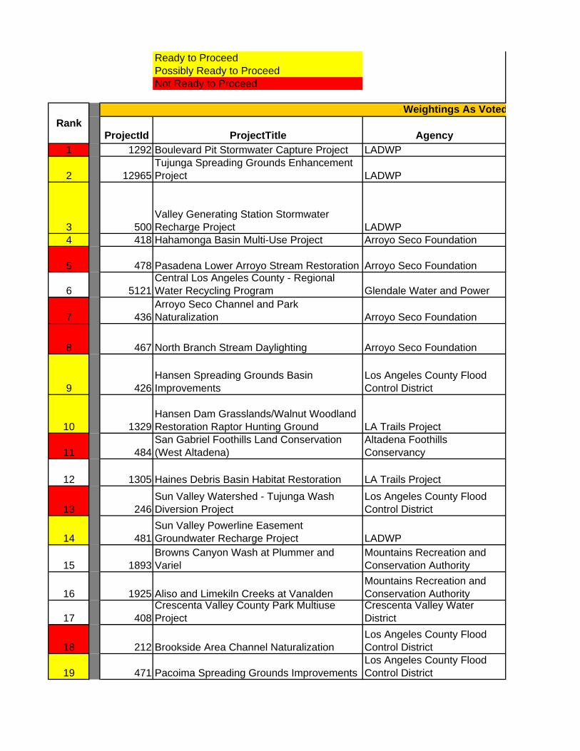
Ready to Proceed Possibly Ready to Proceed
Not Ready to Proceed
ProjectId ProjectTitle Agency1 1292 Boulevard Pit Stormwater Capture Project LADWP
2 12965Tujunga Spreading Grounds Enhancement Project LADWP
3 500Valley Generating Station Stormwater Recharge Project LADWP
4 418 Hahamonga Basin Multi-Use Project Arroyo Seco Foundation
5 478 Pasadena Lower Arroyo Stream Restoration Arroyo Seco Foundation
6 5121Central Los Angeles County - Regional Water Recycling Program Glendale Water and Power
7 436Arroyo Seco Channel and Park Naturalization Arroyo Seco Foundation
8 467 North Branch Stream Daylighting Arroyo Seco Foundation
9 426Hansen Spreading Grounds Basin Improvements
Los Angeles County Flood Control District
10 1329Hansen Dam Grasslands/Walnut Woodland Restoration Raptor Hunting Ground LA Trails Project
11 484San Gabriel Foothills Land Conservation (West Altadena)
Altadena Foothills Conservancy
12 1305 Haines Debris Basin Habitat Restoration LA Trails Project
13 246Sun Valley Watershed - Tujunga Wash Diversion Project
Los Angeles County Flood Control District
14 481Sun Valley Powerline Easement Groundwater Recharge Project LADWP
15 1893Browns Canyon Wash at Plummer and Variel
Mountains Recreation and Conservation Authority
16 1925 Aliso and Limekiln Creeks at VanaldenMountains Recreation and Conservation Authority
17 408Crescenta Valley County Park Multiuse Project
Crescenta Valley Water District
18 212 Brookside Area Channel NaturalizationLos Angeles County Flood Control District
19 471 Pacoima Spreading Grounds ImprovementsLos Angeles County Flood Control District
RankWeightings As Voted

20 1890Brown's Canyon Wash at Route 118 and Rinaldi
Mountains Recreation and Conservation Authority
21 495Woodman Ave. Multi-Beneficial Stormwater Capture Project LADWP
22 1308 Headwaters Corner at CalabasasCity of Calabasas and Mountains Restoration Trust
23 1922Santa Susana Creek at MTA Corridor on Canoga Avenue
Mountains Recreation and Conservation Authority
24 230 Lower Arroyo Park Channel NaturalizationLos Angeles County Flood Control District
25 Deleted- duplicate of #1296526 1774 Community Native Plant Rescue Nursery Ricky Grubb
27 245Sun Valley Watershed - Strathern Pit Multiuse
Los Angeles County Flood Control District
28 1285 Millard Creek Protection/RestorationAltadena Foothills Conservancy
29 8816Urban Interpreters for Environmental Education Program
Resource Conservation District of the Santa Monica Mountains
30 228 Los Angeles River Headwaters, Phase ILos Angeles County Flood Control District
31 1482 Reclamation Equalization Basin City of Burbank
32 1923 Arroyo Calabasas at Fallbrook and HatterasMountains Recreation and Conservation Authority
33 1924 Arroyo Calabasas at Ventura BoulevardMountains Recreation and Conservation Authority
34 1926Aliso Canyon and Los Angeles River Confluence
Mountains Recreation and Conservation Authority
35 1931 Bell Creek Riverfront Natural ParkMountains Recreation and Conservation Authority
36 1932 Lederer RanchMountains Recreation and Conservation Authority
37 13692San Gabriel Foothills Land Conservation (Chaney Trail to Canon)
Altadena Foothills Conservancy
38 10211 SC LA River Open Space City of Los Angeles
39 1898Santa Susana Creek at Topanga Canyon and Plummer
Mountains Recreation and Conservation Authority
40 258Tujunga Wash Restoration Project Section 1135
Los Angeles County Flood Control District
41 1315Equestrian Facilities BMP Education Outreach LA Trails Project
42 133Big Tujunga Dam San Fernando Basin Groundwater Enhancement Project
Los Angeles County Flood Control District
43 5463 Devil's Gate Water Conservation ProjectLos Angeles County Flood Control District
44 13336Upper Arroyo Seco Stream Sustainability Project Arroyo Seco Foundation
45 493 Confluence Gateway Greenway Program Arroyo Seco Foundation

46 1481 Groundwater Replenishment Project City of Burbank
47 3530 Cesar Chavez Recreation ComplexCity of Los Angeles, Department of Public Works
48 8637 Taylor Yard River Park -Parcel G-2City of Los Angeles, Bureau of Engineering

CostReg + Sub-reg
TotalReadiness to
Proceed118 14%
$22M 111 64%
$4-10M depending on attributes ($2.5M- onsite storm flows
capture; $6.5M- utilize gravel pit) 101 71%$26M 88 50%
88 64%
87 50%
84 29%
84 21%Phase 1a underway; Phase 1a - $8-12; Phase 1b - $2M; Phase 2
- Open space, $4M 81 100%
feasibility study - grant app $ not clear 81 42%
land acquisition project (ineligible for 84) 79 38%
79 21%
must aquire sheldon pit first 78 14%
$6-12M 78 64%
77 36%
77 29%
76 21%
74 7%
$9-13M 74 17%
d

74 50%
$1.8M 71 64%
Phase 2 ready to go - $150k 70 29%
69 29%
68 7%
68 14%
$15-$20M construction 67 43%land acquisition project
(ineligible for 84) 66 36%
63 0%
$5-10M 59 57%59 86%
59 21%
59 29%
59 36%
59 93%
59 29%
59 29%
58 36%
57 43%
$5-7M 56 43%
56 29%
~$32M 53 83%
$12-16M 53 0%
$1.5M 53 50%Phase 1 - $2.3M 52 57%

52 79%
50 75%
50 0%