Embed Size (px)
Citation preview
DRAFT TOOLAMBA GROWTH PLAN 2019 1
Greater Shepparton City Council
Toolamba Growth Plan
Consultation Draft – December 2019 December 2019
DRAFT TOOLAMBA GROWTH PLAN 2019 2
Acknowledgements We, Greater Shepparton City Council, acknowledge the Traditional Owners of the land which now comprises Greater Shepparton. We pay respect to their tribal Elders, we celebrate their continuing culture and we acknowledge the memory of their ancestors.
Greater Shepparton City Council gratefully acknowledges the assistance of local government and service agencies, and the Toolamba community in the preparation of this Plan.
GSCC Team Michael MacDonagh Kate Clarke
Study Team Ethos Urban: Tim Peggie Kristen Wilkes Sean Brien
VERSION DATE REVIEWED BY APPROVED BY
1.0 Consultation Draft 17 December 2019 SB/KC TP/MMD
DRAFT TOOLAMBA GROWTH PLAN 2019 3
About the Growth Plan
The Toolamba Growth Plan establishes a framework to guide the sustainable development of Toolamba and Old Toolamba over the next 30 years.
It considers a range of issues, including demographic change, residential growth, transport, facilities, environmental impacts, and maintaining a connected, active community.
The Toolamba Growth Plan identifies the existing context, establishes a future direction and sets out principles manage growth, as well as addressing specific challenges and projects that may impact the townships, to facilitate and support appropriate development and ensure that the benefits of future growth are maximised and shared.
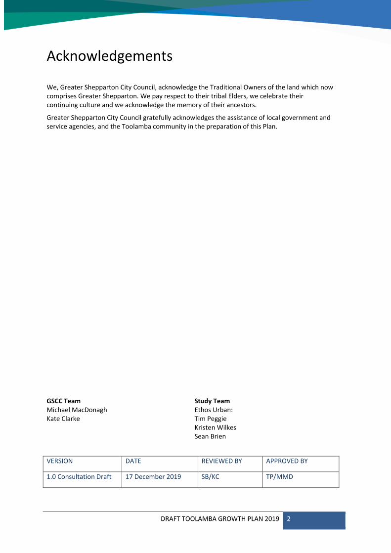
The Plan Process
The development of the Toolamba Growth Plan to date has involved several stages, including pre-draft and draft rounds of consultation with the community, stakeholders and agencies.
Following the current eight-week public consultation period, the draft Plan will be finalised based on community and stakeholder feedback and submitted to Council for Adoption. An Amendment to the Greater Shepparton Planning Scheme will then be undertaken to implement the Plan.
Planning Scheme Amendment
Adoption by Council
Finalisation of the Growth Plan
Public Consultation
Preparation of the draft Growth Plan
Pre-draft Consultation
DRAFT TOOLAMBA GROWTH PLAN 2019 4
Contents
............................................................................................................................................. 4 Contents
1 Introduction ................................................................................................................................ 6
About the Townships.......................................................................................................... 7 1.1
Consultation ....................................................................................................................... 9 1.2
Future Direction ............................................................................................................... 10 1.3
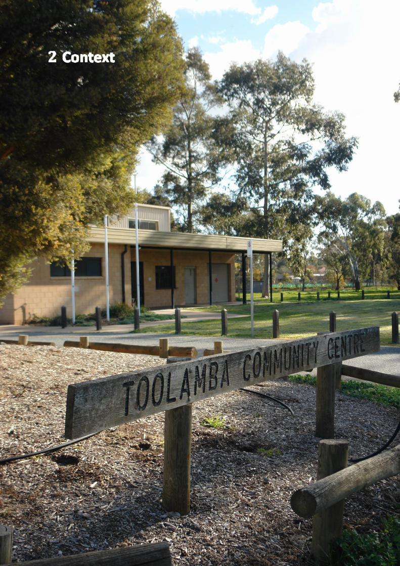
2 Context ..................................................................................................................................... 11
Factors influencing growth ............................................................................................... 12 2.1
Strategic Context .............................................................................................................. 15 2.2
Greater Shepparton Planning Scheme ............................................................................. 18 2.3
Toolamba and District Community Plan ........................................................................... 20 2.4
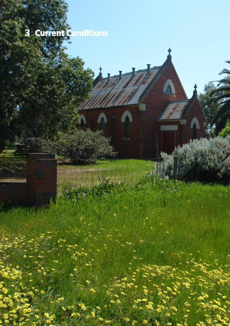
3 Current Conditions .................................................................................................................. 21
Principles for Growth ....................................................................................................... 22 3.1
Housing ............................................................................................................................. 25 3.2
Open Space ....................................................................................................................... 27 3.3
Access & Transport ........................................................................................................... 28 3.4
Employment ..................................................................................................................... 29 3.5
Services ............................................................................................................................. 29 3.6
Education .......................................................................................................................... 29 3.7
4 The Growth Plan ....................................................................................................................... 30
Framework Plan................................................................................................................ 31 4.1
Housing ............................................................................................................................. 35 4.1
Open Space ....................................................................................................................... 41 4.2
Access & Transport ........................................................................................................... 44 4.3
Employment ..................................................................................................................... 47 4.4
Services ............................................................................................................................. 48 4.5
Education .......................................................................................................................... 49 4.6
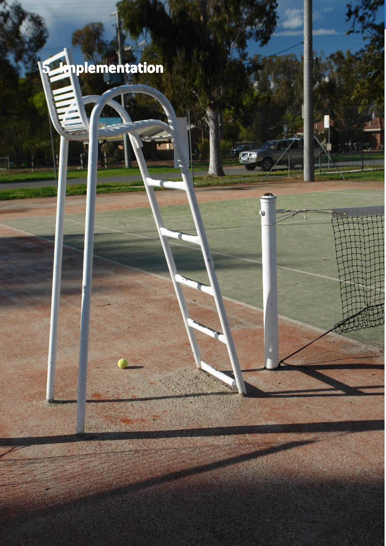
5 Implementation ........................................................................................................................ 50
Action Plan ........................................................................................................................ 51 5.1
Planning Scheme .............................................................................................................. 54 5.2
Appendix – Minimum Lot Sizes of Residential Zones ................................................................... 56
DRAFT TOOLAMBA GROWTH PLAN 2019 5
Executive Summary
While Greater Shepparton’s growth rate has largely remained steady over recent decades, a number of issues may affect the rate of population increase over the next 30 years. These include major infrastructure development projects, such as the Shepparton Art Museum, the GV Health Redevelopment, upgrades to the La Trobe university campus, the Shepparton Stadium Redevelopment, and the construction of the Goulburn Valley Highway Shepparton Bypass. Increasing pressure on peri-urban and regional areas to accommodate population growth to ease Melbourne’s traffic congestion and rising housing market may also impact the municipality’s growth indirectly, as well as broader issues such as environmental sustainability.
Greater Shepparton City Council is aiming to manage future growth to ensure that housing and community infrastructure is provided in a timely and sustainable way.
Although Shepparton, Mooroopna and Kialla are expected to contain a substantial proportion of the anticipated growth, as outlined in the Draft Shepparton and Mooroopna 2050 Regional City Growth Plan 2019, Greater Shepparton’s townships will play an important role in providing a diverse array of lifestyle options to suit changing needs.
Toolamba and Old Toolamba, in the southern area of the locality, were identified as areas of future residential development in the Greater Shepparton Housing Strategy 2011. There are a number of landowners who have expressed interest in subdividing their properties to provide housing. Further, Toolamba will be the only township with its own interchange once Stage 3 of the Goulburn Valley Highway Shepparton Bypass in constructed. As a consequence, Toolamba and Old Toolamba could experience a much faster rate of increase than previously.
The Toolamba Growth Plan identifies residential development opportunities and the potential service and infrastructure requirements to support growth without compromising the townships’ existing character and the natural amenity of its location adjacent to the Goulburn River. It assesses the existing context using the 20-minute neighbourhood framework, and provides direction for future actions across key elements of liveability, housing, access and transport, open space, employment, services, and education.
The Toolamba Growth Plan provides a basis for assessment of prospective applications for rezoning, setting out a future direction and key principles to ensure growth is well planned to benefit the townships as a whole.
DRAFT TOOLAMBA GROWTH PLAN 2019 6
DRAFT TOOLAMBA GROWTH PLAN 2019 7
About the Townships 1.1
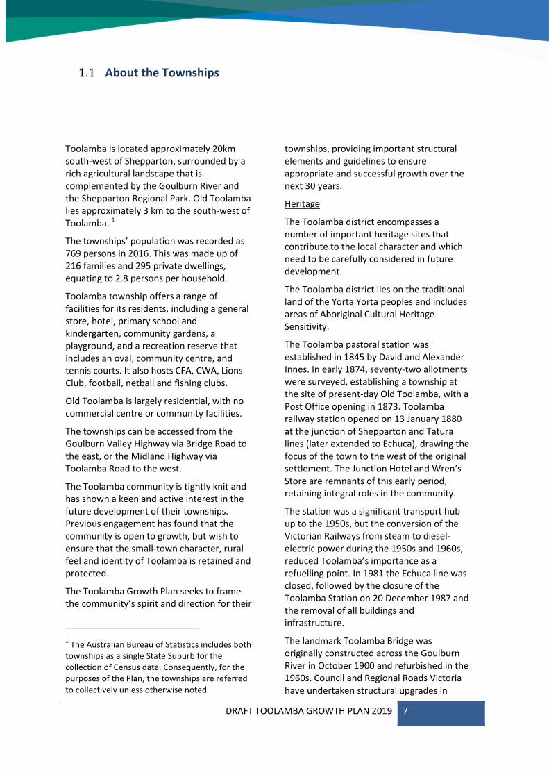
Toolamba is located approximately 20km south-west of Shepparton, surrounded by a rich agricultural landscape that is complemented by the Goulburn River and the Shepparton Regional Park. Old Toolamba lies approximately 3 km to the south-west of Toolamba. 1
The townships’ population was recorded as 769 persons in 2016. This was made up of 216 families and 295 private dwellings, equating to 2.8 persons per household.
Toolamba township offers a range of facilities for its residents, including a general store, hotel, primary school and kindergarten, community gardens, a playground, and a recreation reserve that includes an oval, community centre, and tennis courts. It also hosts CFA, CWA, Lions Club, football, netball and fishing clubs.
Old Toolamba is largely residential, with no commercial centre or community facilities.
The townships can be accessed from the Goulburn Valley Highway via Bridge Road to the east, or the Midland Highway via Toolamba Road to the west.
The Toolamba community is tightly knit and has shown a keen and active interest in the future development of their townships. Previous engagement has found that the community is open to growth, but wish to ensure that the small-town character, rural feel and identity of Toolamba is retained and protected.
The Toolamba Growth Plan seeks to frame the community’s spirit and direction for their
1 The Australian Bureau of Statistics includes both
townships as a single State Suburb for the collection of Census data. Consequently, for the purposes of the Plan, the townships are referred to collectively unless otherwise noted.
townships, providing important structural elements and guidelines to ensure appropriate and successful growth over the next 30 years.
Heritage
The Toolamba district encompasses a number of important heritage sites that contribute to the local character and which need to be carefully considered in future development.
The Toolamba district lies on the traditional land of the Yorta Yorta peoples and includes areas of Aboriginal Cultural Heritage Sensitivity.
The Toolamba pastoral station was established in 1845 by David and Alexander Innes. In early 1874, seventy-two allotments were surveyed, establishing a township at the site of present-day Old Toolamba, with a Post Office opening in 1873. Toolamba railway station opened on 13 January 1880 at the junction of Shepparton and Tatura lines (later extended to Echuca), drawing the focus of the town to the west of the original settlement. The Junction Hotel and Wren’s Store are remnants of this early period, retaining integral roles in the community.
The station was a significant transport hub up to the 1950s, but the conversion of the Victorian Railways from steam to diesel-electric power during the 1950s and 1960s, reduced Toolamba’s importance as a refuelling point. In 1981 the Echuca line was closed, followed by the closure of the Toolamba Station on 20 December 1987 and the removal of all buildings and infrastructure.
The landmark Toolamba Bridge was originally constructed across the Goulburn River in October 1900 and refurbished in the 1960s. Council and Regional Roads Victoria have undertaken structural upgrades in
DRAFT TOOLAMBA GROWTH PLAN 2019 8
2019, with duplication of the bridge expected in approximately 10 years, at the end of its functional life. The historic bridge will then be preserved for its heritage significance.
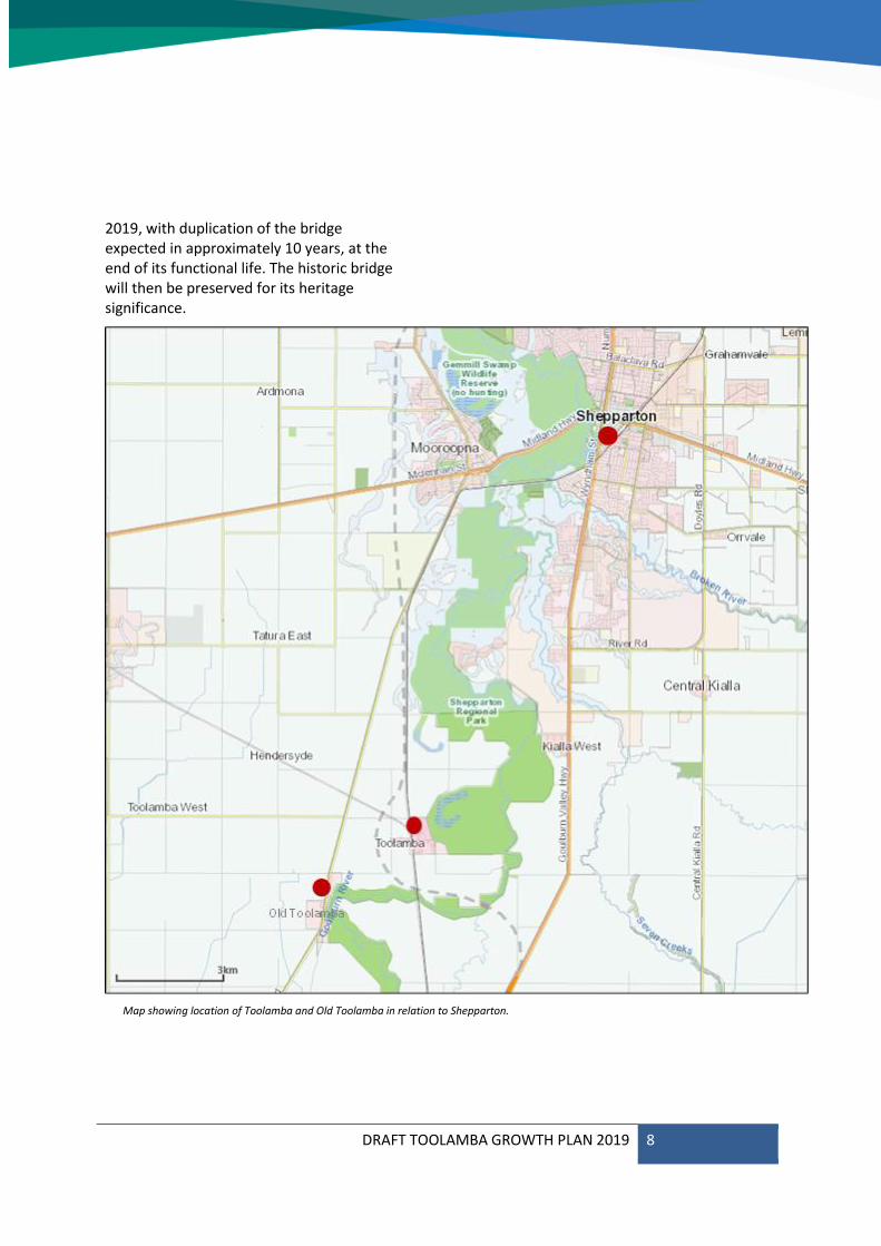
Map showing location of Toolamba and Old Toolamba in relation to Shepparton.
DRAFT TOOLAMBA GROWTH PLAN 2019 9
Consultation1.2
Pre-draft Consultation
A variety of factors will influence the development of Toolamba. The Pre-draft Consultation aimed to ensure that these factors were fully understood prior to beginning work on the Growth Plan.
A range of activities were undertaken to ensure that the community and stakeholders had an opportunity to provide input into the Growth Plan as outlined below.
Council facilitated a workshop with key referral agencies to identify issues that may affect Toolamba’s growth, and met with several landowners to discuss prospective plans for residential development. Agencies in attendance included:
The Department of Land, Water and Planning;
Goulburn Valley Water;
Goulburn Broken Catchment Management Authority;
VicTrack; and
Environmental Protection Authority.
Members of the community were asked to respond to the following questions via an online survey or at a drop-in session held on
9 May 2019 at the Toolamba Community Hall:
What do you love about Toolamba townships?
What physical characteristics would you like to see retained in the future?
What words describe how you imagine Toolamba townships in 2050?
What changes would make Toolamba Townships even better in the long term?
A total of 182 responses were received, providing 404 suggestions, ideas and comments. Six responses to the children’s survey were also received, with 19 comments and ideas.
The comments received are explained in more detail in the Toolamba Growth Plan Pre-draft Engagement Conversation Report 2019 and have been incorporated into this Plan.
Draft Consultation
The findings of the current consultation on the Draft Plan will be considered for the final version of the Growth Plan.
DRAFT TOOLAMBA GROWTH PLAN 2019 10
Toolamba: a growing town offering a relaxed rural lifestyle in a quiet and
spacious landscaped setting, supporting its community to be healthy, connected,
and active.
Future Direction1.3
During pre-draft consultation with the community, residents were asked what they love about Toolamba, and how they see its future. A number of key themes emerged from the responses, demonstrating the importance of retaining the towns’ unique characters as they grow, preserving natural features, and enabling the community to remain physically and socially connected.
The future direction for Toolamba, below, embraces these themes, guiding the preparation of the Toolamba Growth Plan and providing an on-going direction for the Townships’ future development.
DRAFT TOOLAMBA GROWTH PLAN 2019 11
DRAFT TOOLAMBA GROWTH PLAN 2019 12
Factors influencing growth 2.1
Toolamba’s past growth has been sporadic and incremental. In the future, two significant factors may influence the current rate of growth. These are the rezoning of substantial tracts of land along with the provision of reticulated sewerage infrastructure and the construction of the Goulburn Valley Highway Shepparton Bypass. Both factors may result in increased development in the coming decades exceeding the growth that has previously been experienced.
Demographic Change
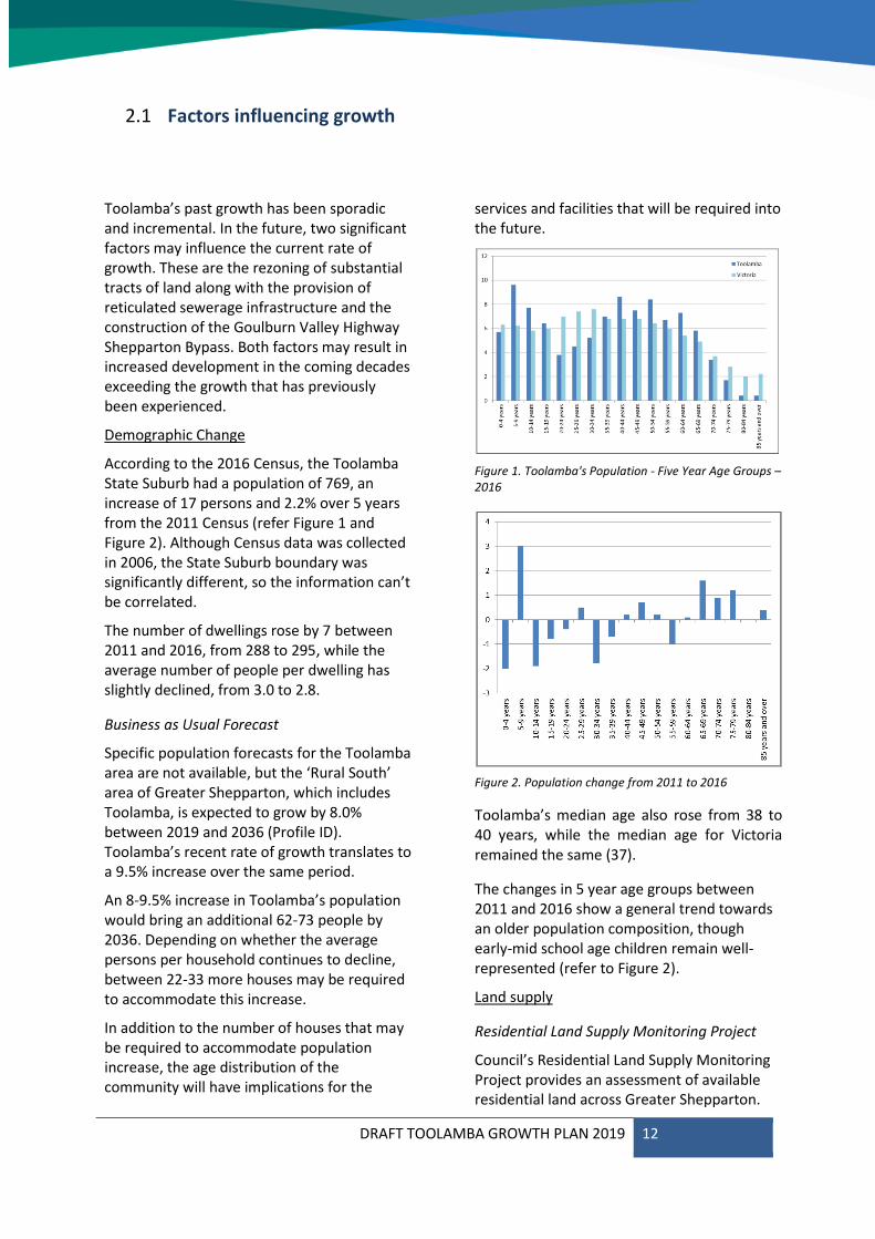
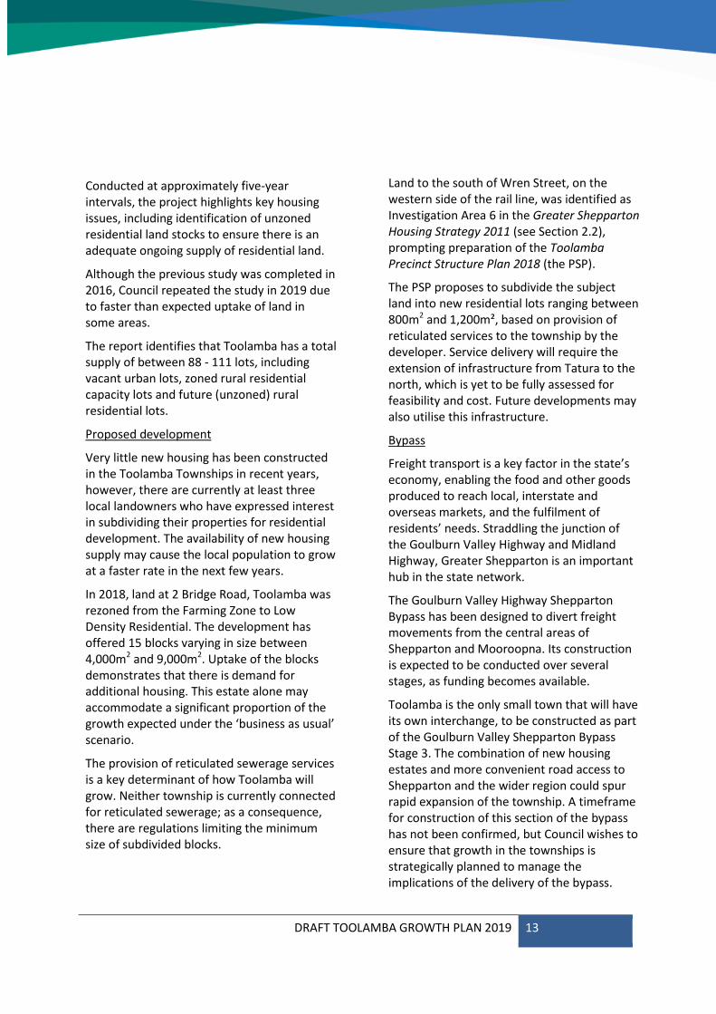
According to the 2016 Census, the Toolamba State Suburb had a population of 769, an increase of 17 persons and 2.2% over 5 years from the 2011 Census (refer Figure 1 and Figure 2). Although Census data was collected in 2006, the State Suburb boundary was significantly different, so the information can’t be correlated.
The number of dwellings rose by 7 between 2011 and 2016, from 288 to 295, while the average number of people per dwelling has slightly declined, from 3.0 to 2.8.
Business as Usual Forecast
Specific population forecasts for the Toolamba area are not available, but the ‘Rural South’ area of Greater Shepparton, which includes Toolamba, is expected to grow by 8.0% between 2019 and 2036 (Profile ID). Toolamba’s recent rate of growth translates to a 9.5% increase over the same period.
An 8-9.5% increase in Toolamba’s population would bring an additional 62-73 people by 2036. Depending on whether the average persons per household continues to decline, between 22-33 more houses may be required to accommodate this increase.
In addition to the number of houses that may be required to accommodate population increase, the age distribution of the community will have implications for the
services and facilities that will be required into the future.
Figure 1. Toolamba's Population - Five Year Age Groups – 2016
Figure 2. Population change from 2011 to 2016
Toolamba’s median age also rose from 38 to 40 years, while the median age for Victoria remained the same (37).
The changes in 5 year age groups between 2011 and 2016 show a general trend towards an older population composition, though early-mid school age children remain well-represented (refer to Figure 2).
Land supply
Residential Land Supply Monitoring Project
Council’s Residential Land Supply Monitoring Project provides an assessment of available residential land across Greater Shepparton.
DRAFT TOOLAMBA GROWTH PLAN 2019 13
Conducted at approximately five-year intervals, the project highlights key housing issues, including identification of unzoned residential land stocks to ensure there is an adequate ongoing supply of residential land.
Although the previous study was completed in 2016, Council repeated the study in 2019 due to faster than expected uptake of land in some areas.
The report identifies that Toolamba has a total supply of between 88 - 111 lots, including vacant urban lots, zoned rural residential capacity lots and future (unzoned) rural residential lots.
Proposed development
Very little new housing has been constructed in the Toolamba Townships in recent years, however, there are currently at least three local landowners who have expressed interest in subdividing their properties for residential development. The availability of new housing supply may cause the local population to grow at a faster rate in the next few years.
In 2018, land at 2 Bridge Road, Toolamba was rezoned from the Farming Zone to Low Density Residential. The development has offered 15 blocks varying in size between 4,000m2 and 9,000m2. Uptake of the blocks demonstrates that there is demand for additional housing. This estate alone may accommodate a significant proportion of the growth expected under the ‘business as usual’ scenario.
The provision of reticulated sewerage services is a key determinant of how Toolamba will grow. Neither township is currently connected for reticulated sewerage; as a consequence, there are regulations limiting the minimum size of subdivided blocks.
Land to the south of Wren Street, on the western side of the rail line, was identified as Investigation Area 6 in the Greater Shepparton Housing Strategy 2011 (see Section 2.2), prompting preparation of the Toolamba Precinct Structure Plan 2018 (the PSP).
The PSP proposes to subdivide the subject land into new residential lots ranging between 800m2 and 1,200m², based on provision of reticulated services to the township by the developer. Service delivery will require the extension of infrastructure from Tatura to the north, which is yet to be fully assessed for feasibility and cost. Future developments may also utilise this infrastructure.
Bypass
Freight transport is a key factor in the state’s economy, enabling the food and other goods produced to reach local, interstate and overseas markets, and the fulfilment of residents’ needs. Straddling the junction of the Goulburn Valley Highway and Midland Highway, Greater Shepparton is an important hub in the state network.
The Goulburn Valley Highway Shepparton Bypass has been designed to divert freight movements from the central areas of Shepparton and Mooroopna. Its construction is expected to be conducted over several stages, as funding becomes available.
Toolamba is the only small town that will have its own interchange, to be constructed as part of the Goulburn Valley Shepparton Bypass Stage 3. The combination of new housing estates and more convenient road access to Shepparton and the wider region could spur rapid expansion of the township. A timeframe for construction of this section of the bypass has not been confirmed, but Council wishes to ensure that growth in the townships is strategically planned to manage the implications of the delivery of the bypass.
DRAFT TOOLAMBA GROWTH PLAN 2019 14
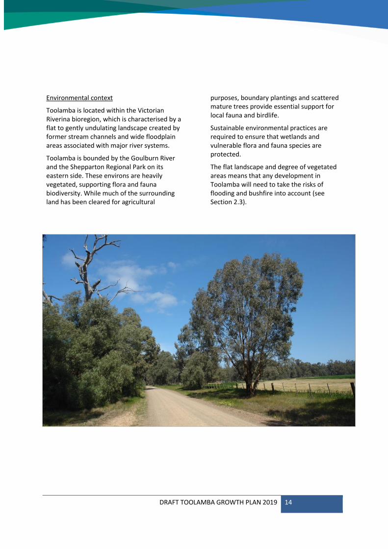
Environmental context
Toolamba is located within the Victorian Riverina bioregion, which is characterised by a flat to gently undulating landscape created by former stream channels and wide floodplain areas associated with major river systems.
Toolamba is bounded by the Goulburn River and the Shepparton Regional Park on its eastern side. These environs are heavily vegetated, supporting flora and fauna biodiversity. While much of the surrounding land has been cleared for agricultural
purposes, boundary plantings and scattered mature trees provide essential support for local fauna and birdlife.
Sustainable environmental practices are required to ensure that wetlands and vulnerable flora and fauna species are protected.
The flat landscape and degree of vegetated areas means that any development in Toolamba will need to take the risks of flooding and bushfire into account (see Section 2.3).

DRAFT TOOLAMBA GROWTH PLAN 2019 15
Strategic Context2.2
State Strategy
Victorian Planning Provisions
The Planning Policy Framework (PPF) provides the broad objectives and strategies for the State of Victoria in relation to key future directions.
The most relevant provisions are:
• Clause 11 Settlement
• Clause 13 Environmental Risks and Amenity
• Clause 14 Natural Resource Management
• Clause 15 Built Environment and Heritage
• Clause 16 Housing
• Clause 18 Transport
• Clause 19 Infrastructure
Plan Melbourne 2050
Plan Melbourne 2050 provides a high level planning strategy for Melbourne that addresses future population and employment growth in the capital city, as well as the expansion and strengthening of physical, economic and social links across the state.
Although Plan Melbourne 2050 is predominantly a metropolitan planning strategy, it shapes the overarching approach to development across the state, particularly in regards to the principle of 20-minute neighbourhoods.
The application of a 20-minute neighbourhood framework is intended to guide development and infrastructure provision to enable residents to fulfil their needs within a 20-minute walk, cycle or public transport ride of their home.
The framework provides a useful tool for assessment of Toolamba’s existing and potential capacity. It is discussed further in Section 3.
Delivering the goods: Victorian Freight Plan 2018
Delivering the Goods 2018 sets out priorities to support Victoria’s freight and logistics systems through a period of unprecedented growth and change in response to increasing demand, global trends and technological innovation.
Greater Shepparton is a key freight hub, due to its position at the junction of the Goulburn Valley Highway and the Midland Highway, and the extent of its agricultural industries. The Goulburn Valley Highway Shepparton Bypass will divert freight movements away from the highly urbanised areas of Shepparton and Mooroopna.
Regional Strategy
Hume Regional Growth Plan
The Hume Regional Growth Plan encompasses the municipalities of Alpine, Benalla, Greater Shepparton, Indigo, Mansfield, Mitchell, Moira, Murrindindi, Strathbogie, Towong, Wangaratta and Wodonga. The plan provides broad direction for regional land use and development, outlining more detailed planning frameworks for key regional centres.
The plan identifies Shepparton as the location for major growth and Toolamba is included within the ‘Hinterland influence’ catchment that surrounds Shepparton. Growth in the hinterland influence catchment needs to be managed to achieve an efficient settlement pattern.
Local Strategies and Plans
Greater Shepparton 2030 Strategy
The Greater Shepparton 2030 Strategy (2006) provides a long-term vision for Greater Shepparton to guide planning, leadership, decision making and expectations about the municipality into the future. It includes a Framework Plan for Toolamba, but this has since been refined by the Greater Shepparton
DRAFT TOOLAMBA GROWTH PLAN 2019 16
Housing Strategy 2011, and the Township Frameworks Plan Review 2018.
Greater Shepparton Council Plan 2017-2021
The Council Plan sets out Council’s Vision for Greater Shepparton to be a thriving economy in the food bowl of Victoria with excellent lifestyles, innovative agriculture, a diverse community, and abundant opportunities.
Incorporating the Municipal Health and Wellbeing Plan, the Council Plan aims to ensure that the municipality continues to be a place where people want to live, now and in the future.
Greater Shepparton Housing Strategy
The Greater Shepparton Housing Strategy 2011 emphasises the need for planning to fulfil short and long-term housing needs, to provide for consolidated and sustainable growth, to respect the existing characters of Greater Shepparton’s diverse housing settings, and to enable efficient management of the development process to benefit the entire community.
The strategy recognises Toolamba as having a unique setting, and the importance of managing the rate of development to protect its character. It notes that there is potential for reticulated sewerage services, and designates the land at 335 Rutherford Road Toolamba as Investigation Area 6, requiring further work on land conditions, servicing and development potential prior to consideration of rezoning.
The Strategy also nominated both townships as Minimal Change Areas due to their strong rural neighbourhood characteristics, vulnerability to environmental factors such as flooding, and valued landscape features. The Growth Area Plan has since been updated in the Greater Shepparton Townships Framework Plan Review (see below).
The objectives in managing residential development in Minimal Change Areas are to
ensure that existing scale, character, and historic buildings are respected, that development does not cause detrimental impacts to significant natural features, and that environmentally friendly technologies are supported in new constructions.
Greater Shepparton Townships Framework Plan Review
The Greater Shepparton Townships Framework Plan Review (2018) reviews nine township Framework Plans from the Greater Shepparton Housing Strategy 2011, including Toolamba, to reflect changes that have occurred since 2011.
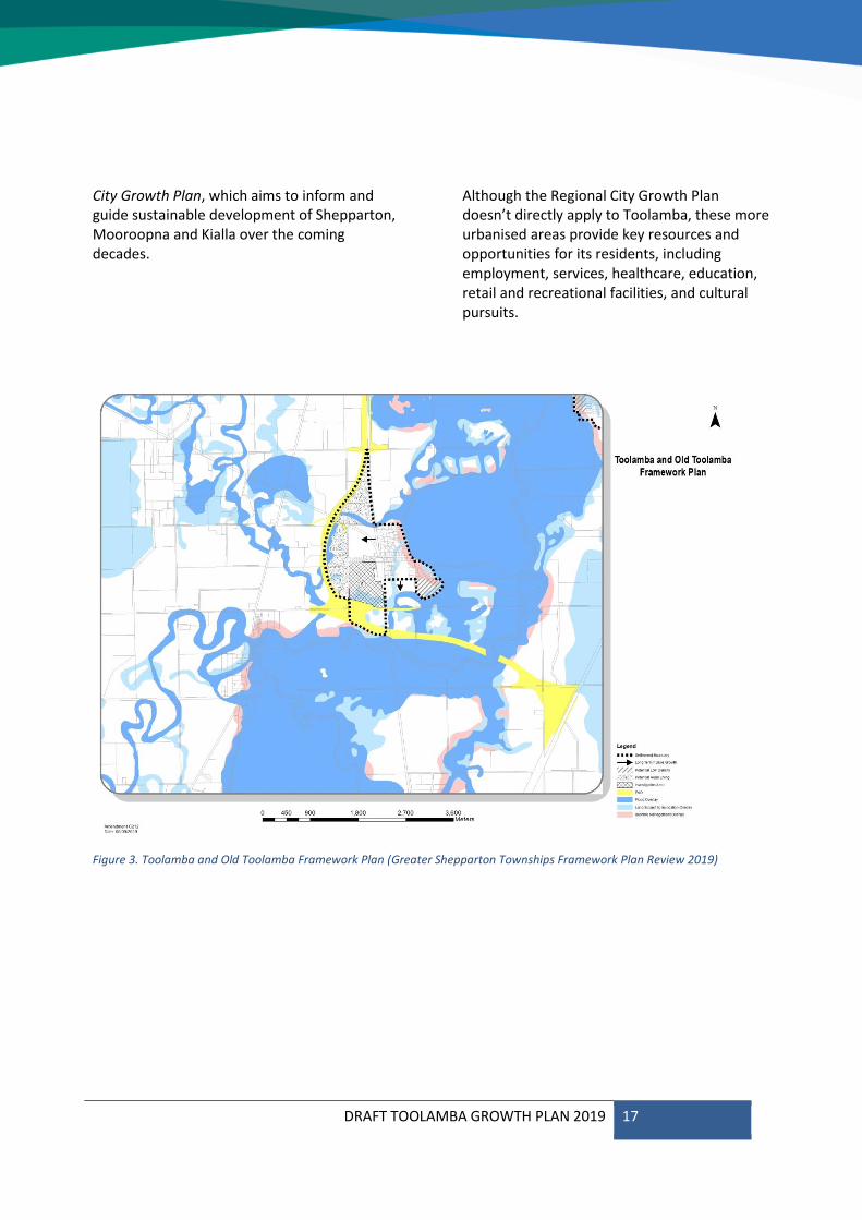
The revised version of the Toolamba and Old Toolamba Framework Plan (Figure 3) displays overlays affecting the area (Bushfire Management, Floodway and Land Subject to Inundation), removes Investigation Area 6 from classification as an area for ‘Long Term Future Growth’, and corrects an anomaly in the settlement boundary, as shown in the map, opposite. Amendment C212 is underway to incorporate the review into the Greater Shepparton Planning Scheme, with final approval expected in early 2020.
Greater Shepparton Cycling Strategy 2013-2017
Council is keen to promote cycling due to the wide-ranging health, tourism and environmental benefits, including staged implementation of a connected and continuous cycling network. The Cycling Strategy (2013) identifies Toolamba and Old Toolamba as potential links in recreational cycling networks aligned to railway corridors, river and road systems.
Shepparton and Mooroopna 2050: Regional City Growth Plan
While developing the Toolamba Growth Plan, Council are also working with the Victorian Planning Authority (VPA) to prepare the Shepparton and Mooroopna 2050: Regional
DRAFT TOOLAMBA GROWTH PLAN 2019 17
City Growth Plan, which aims to inform and guide sustainable development of Shepparton, Mooroopna and Kialla over the coming decades.
Although the Regional City Growth Plan doesn’t directly apply to Toolamba, these more urbanised areas provide key resources and opportunities for its residents, including employment, services, healthcare, education, retail and recreational facilities, and cultural pursuits.
Figure 3. Toolamba and Old Toolamba Framework Plan (Greater Shepparton Townships Framework Plan Review 2019)
DRAFT TOOLAMBA GROWTH PLAN 2019 18
Greater Shepparton Planning Scheme 2.3
The Greater Shepparton Planning Scheme guides use and development of land across the municipality.
The Local Planning Policy Framework provides over-arching objectives and strategies for sustainable development across the municipality.
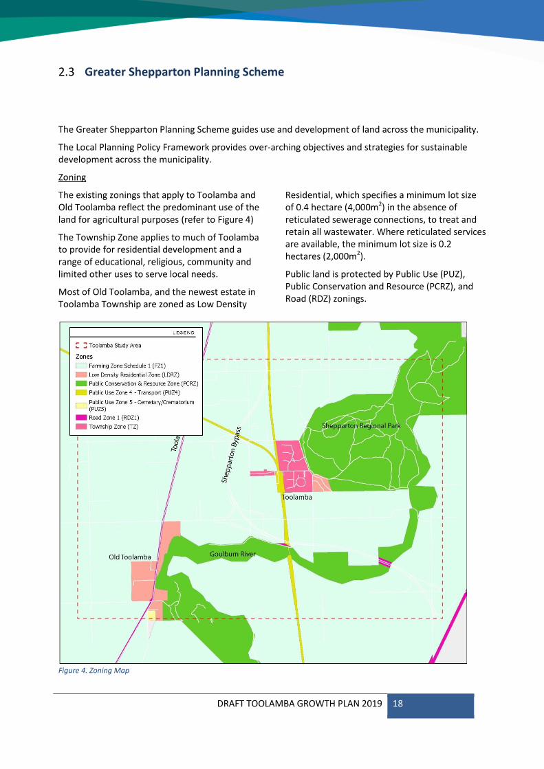
Zoning
The existing zonings that apply to Toolamba and Old Toolamba reflect the predominant use of the land for agricultural purposes (refer to Figure 4)
The Township Zone applies to much of Toolamba to provide for residential development and a range of educational, religious, community and limited other uses to serve local needs.
Most of Old Toolamba, and the newest estate in Toolamba Township are zoned as Low Density
Residential, which specifies a minimum lot size of 0.4 hectare (4,000m2) in the absence of reticulated sewerage connections, to treat and retain all wastewater. Where reticulated services are available, the minimum lot size is 0.2 hectares (2,000m2).
Public land is protected by Public Use (PUZ), Public Conservation and Resource (PCRZ), and Road (RDZ) zonings.
Figure 4. Zoning Map
DRAFT TOOLAMBA GROWTH PLAN 2019 19
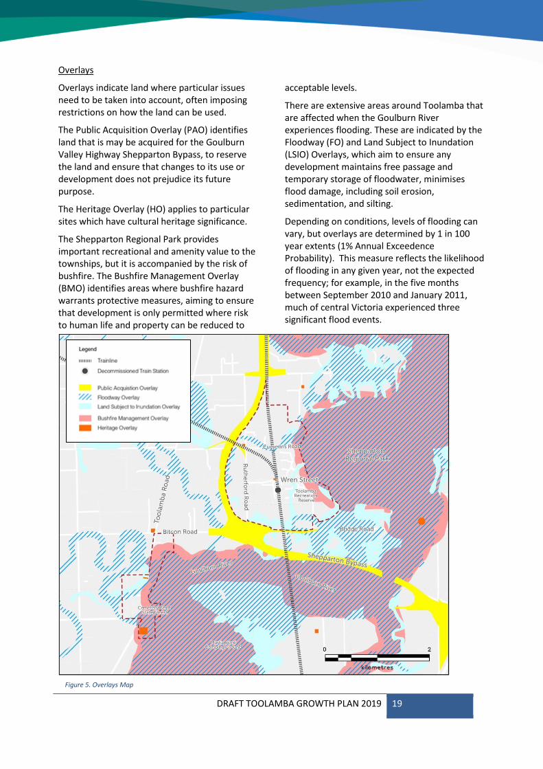
Overlays
Overlays indicate land where particular issues need to be taken into account, often imposing restrictions on how the land can be used.
The Public Acquisition Overlay (PAO) identifies land that is may be acquired for the Goulburn Valley Highway Shepparton Bypass, to reserve the land and ensure that changes to its use or development does not prejudice its future purpose.
The Heritage Overlay (HO) applies to particular sites which have cultural heritage significance.
The Shepparton Regional Park provides important recreational and amenity value to the townships, but it is accompanied by the risk of bushfire. The Bushfire Management Overlay (BMO) identifies areas where bushfire hazard warrants protective measures, aiming to ensure that development is only permitted where risk to human life and property can be reduced to
acceptable levels.
There are extensive areas around Toolamba that are affected when the Goulburn River experiences flooding. These are indicated by the Floodway (FO) and Land Subject to Inundation (LSIO) Overlays, which aim to ensure any development maintains free passage and temporary storage of floodwater, minimises flood damage, including soil erosion, sedimentation, and silting.
Depending on conditions, levels of flooding can vary, but overlays are determined by 1 in 100 year extents (1% Annual Exceedence Probability). This measure reflects the likelihood of flooding in any given year, not the expected frequency; for example, in the five months between September 2010 and January 2011, much of central Victoria experienced three significant flood events.
Figure 5. Overlays Map
DRAFT TOOLAMBA GROWTH PLAN 2019 20
Toolamba and District Community Plan 2.4
The Toolamba community have a keen and active interest in the future development of both townships and are open to growth that retains the small-town character and unique community spirit of Toolamba.
The Toolamba and District Community Plan was originally developed in 2011 and updated in 2016. It includes an Action Plan that is reviewed annually to reflect the changing needs and aspirations of the community.
The implementation of the Plan is driven by the community, but many of its actions are closely aligned to those of the Toolamba Growth Plan. Some of the goals in the Community Plan have been incorporated into the Growth Plan, including:
Provision of a range of community activities and facilities
Provision of walking tracks
Improvement of kerb / channel / guttering
Support heritage
Public transport connection
DRAFT TOOLAMBA GROWTH PLAN 2019 21
DRAFT TOOLAMBA GROWTH PLAN 2019 22
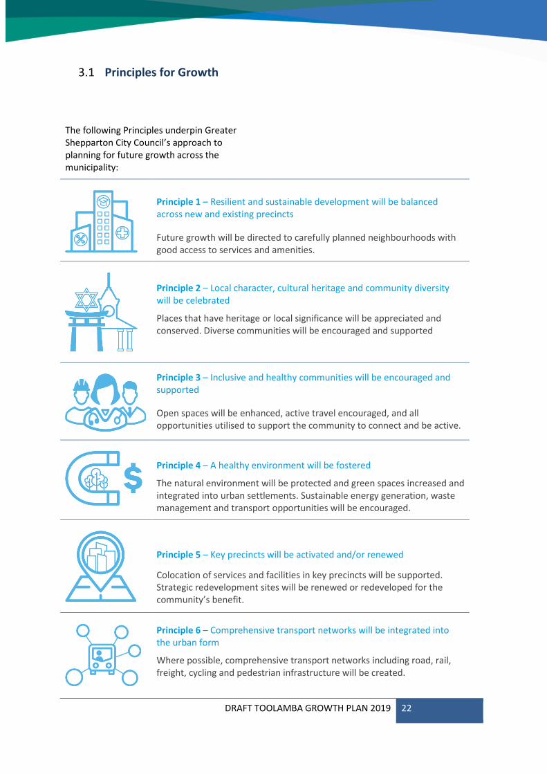
Principles for Growth3.1
The following Principles underpin Greater Shepparton City Council’s approach to planning for future growth across the municipality:
Principle 1 – Resilient and sustainable development will be balanced across new and existing precincts
Future growth will be directed to carefully planned neighbourhoods with good access to services and amenities.
Principle 2 – Local character, cultural heritage and community diversity will be celebrated
Places that have heritage or local significance will be appreciated and conserved. Diverse communities will be encouraged and supported
Principle 3 – Inclusive and healthy communities will be encouraged and supported
Open spaces will be enhanced, active travel encouraged, and all opportunities utilised to support the community to connect and be active.
Principle 4 – A healthy environment will be fostered
The natural environment will be protected and green spaces increased and integrated into urban settlements. Sustainable energy generation, waste management and transport opportunities will be encouraged.
Principle 5 – Key precincts will be activated and/or renewed
Colocation of services and facilities in key precincts will be supported. Strategic redevelopment sites will be renewed or redeveloped for the community’s benefit.
Principle 6 – Comprehensive transport networks will be integrated into the urban form
Where possible, comprehensive transport networks including road, rail, freight, cycling and pedestrian infrastructure will be created.
DRAFT TOOLAMBA GROWTH PLAN 2019 23
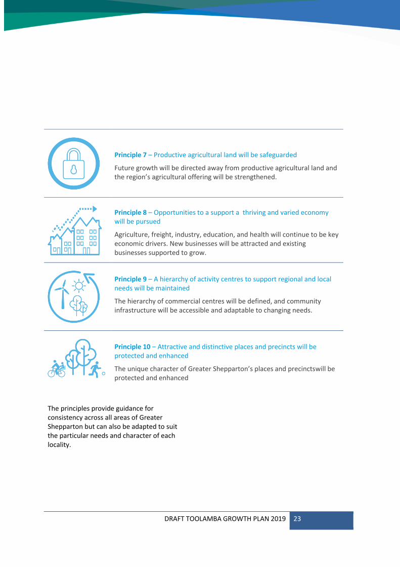
Principle 7 – Productive agricultural land will be safeguarded
Future growth will be directed away from productive agricultural land and the region’s agricultural offering will be strengthened.
Principle 8 – Opportunities to a support a thriving and varied economy will be pursued
Agriculture, freight, industry, education, and health will continue to be key economic drivers. New businesses will be attracted and existing businesses supported to grow.
Principle 9 – A hierarchy of activity centres to support regional and local needs will be maintained
The hierarchy of commercial centres will be defined, and community infrastructure will be accessible and adaptable to changing needs.
Principle 10 – Attractive and distinctive places and precincts will be protected and enhanced
The unique character of Greater Shepparton’s places and precinctswill be protected and enhanced
The principles provide guidance for consistency across all areas of Greater Shepparton but can also be adapted to suit the particular needs and character of each locality.
DRAFT TOOLAMBA GROWTH PLAN 2019 24
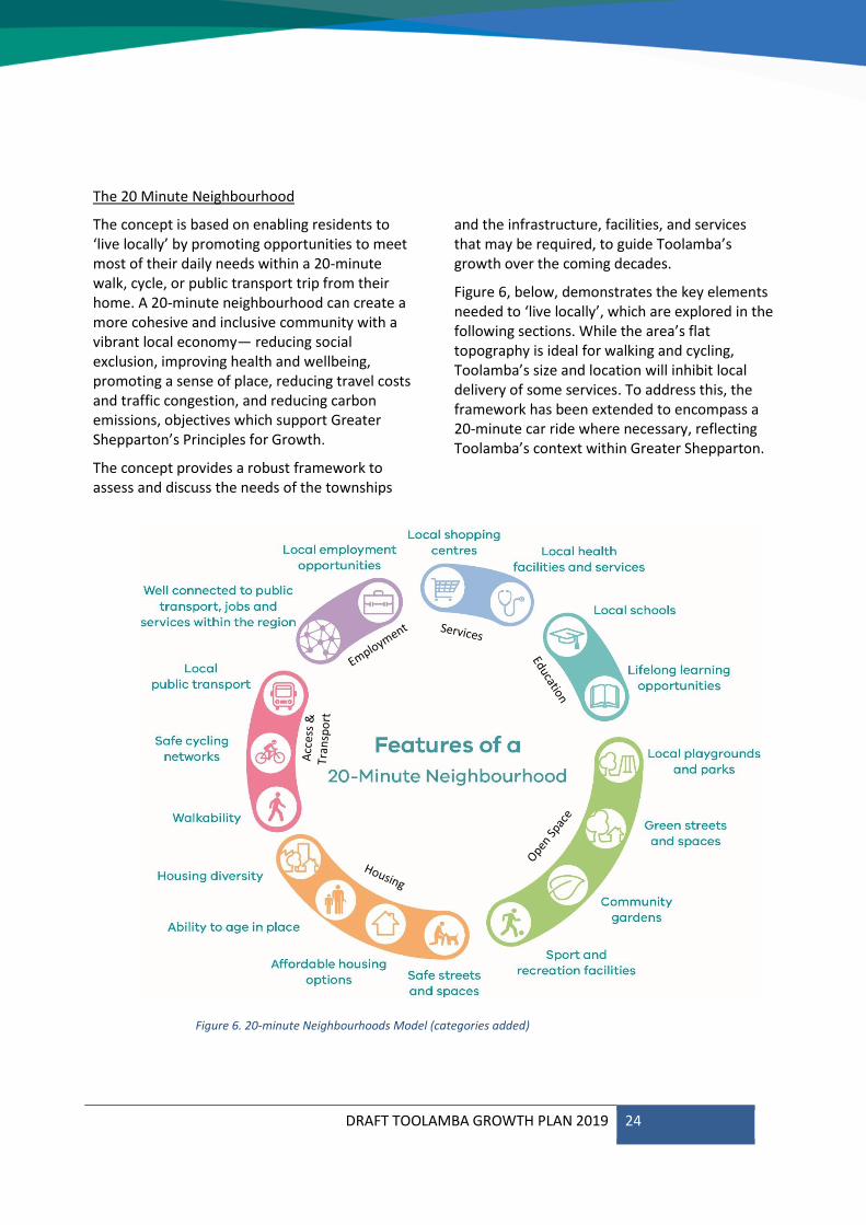
The 20 Minute Neighbourhood
The concept is based on enabling residents to ‘live locally’ by promoting opportunities to meet most of their daily needs within a 20-minute walk, cycle, or public transport trip from their home. A 20-minute neighbourhood can create a more cohesive and inclusive community with a vibrant local economy— reducing social exclusion, improving health and wellbeing, promoting a sense of place, reducing travel costs and traffic congestion, and reducing carbon emissions, objectives which support Greater Shepparton’s Principles for Growth.
The concept provides a robust framework to assess and discuss the needs of the townships
and the infrastructure, facilities, and services that may be required, to guide Toolamba’s growth over the coming decades.
Figure 6, below, demonstrates the key elements needed to ‘live locally’, which are explored in the following sections. While the area’s flat topography is ideal for walking and cycling, Toolamba’s size and location will inhibit local delivery of some services. To address this, the framework has been extended to encompass a 20-minute car ride where necessary, reflecting Toolamba’s context within Greater Shepparton.
Figure 6. 20-minute Neighbourhoods Model (categories added)
DRAFT TOOLAMBA GROWTH PLAN 2019 25
Housing 3.2
Housing diversity
According to 2016 Census data, Toolamba’s housing stock is entirely comprised of detached dwellings, with no units, townhouses or apartments. Of this stock, 52.9% of stock is 3 bedroom, 40.0% four or more bedrooms, and only 5.9% are 1 or 2 bedrooms, although 15.2% of households are single person. Only 14.6% of dwellings are rented, with 51% under mortgage, and 33.2% owned outright.
While the built form varies widely, large setbacks and substantial vegetation are consistent elements of the streetscapes, enabled by the necessary minimum 4,000m2 block size where reticulated sewerage services are not available. Smaller blocks along Wren Street pre-date these planning requirements, but mature trees along and behind the streetscape ensure harmonious blending. Toolamba’s spaciousness and greenery are primary elements in the rural character of the townships, identified as key characteristics in community consultation for both current enjoyment and future aspiration.
Ability to age in place
Toolamba’s close-knit community and network of community-based activities and organisations are likely to provide the social support and potentially also physical support for ageing members of the community. However, the built form of the townships is not highly conducive to fulfilling the needs of older people. More than 90% of houses have 3 or more bedrooms, leaving few options to downsize into a smaller home, and all are located on individual blocks that create significant maintenance burdens. While Toolamba township is currently small enough to be within a 20-minute walk or cycle of the general store, playground and hotel, the absence of footpaths is a hazard for those with limited mobility. In addition, if a resident is unable to drive, employment, medical services, and other services and facilities available in
Kialla, Shepparton and Mooroopna may be out of reach, restricting the fulfilment of daily needs.
Affordable Housing options
Current property prices in Toolamba are inherently ‘affordable’, with both median rent and median mortgage repayments that are lower than state and national figures. The abundant supply of land that is suitable for residential development around Toolamba suggests extensive capacity for staged release to maintain affordability for those able to enter the market. However, the provision of infrastructure to secure the supply of reticulated sewerage services is likely to add a considerable amount to purchase prices.
The 2016 Census indicated that 10.5% of households with mortgages paying more than 30% of their income on housing costs, compared to 7.5% across the state. The existing lack of diversity in housing size and configuration, and the low number of rental properties, are not favourable for the provision of Affordable Housing, which is defined by the Planning and Environment Act 1987 as ‘housing, including Social Housing, that is appropriate for the needs of very low, low, and moderate income households’. There are few options available for households to respond to changes in circumstance without moving out of the townships.
Safe streets and spaces
The feeling of safety and security in Toolamba was the second most popular response to the Community Consultation question ‘What do you love about Toolamba?’, relating closely to the first, the connected and friendly community, a primary factor in passive surveillance. Both also featured strongly in the aspirations for 2050. There is a particular association with the ability for children to navigate and move around the townships by themselves. Census data indicates that all
DRAFT TOOLAMBA GROWTH PLAN 2019 26
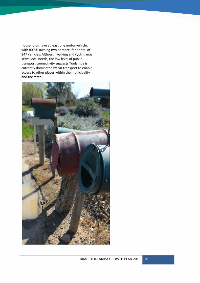
households have at least one motor vehicle, with 80.8% owning two or more, for a total of 247 vehicles. Although walking and cycling may serve local needs, the low level of public transport connectivity suggests Toolamba is currently dominated by car transport to enable access to other places within the municipality and the state.
DRAFT TOOLAMBA GROWTH PLAN 2019 27
Open Space 3.3
Local playgrounds, parks and community gardens
Colaura Gardens is centrally located on Wren Street, adjacent to the General Store. It is named for two local girls whose lives were lost in 2006 and features a memorial garden. It provides a playground, open space, public toilets, BBQ facilities and pavilion, book exchange, water fountain, shaded areas and seating, as well as directional and interpretive signage for the town.
Toolamba enjoys proximity to the Shepparton Regional Park, with a network of tracks providing access to Daunts Bend to the east, and an approach to the Goulburn River to the south from Rutherford Road. The natural amenity of the locality is highly valued by the community, particularly the bird- and wildlife.
Green streets and spaces
Mature trees and vegetation are an important characteristic of the townships, a foundation of its rural identity.
Sport and recreation facilities
The Toolamba Recreation Reserve is a significant sport and recreation facility, offering tennis courts, sports oval, public toilets, and Community Centre with kitchen facilities.
DRAFT TOOLAMBA GROWTH PLAN 2019 28
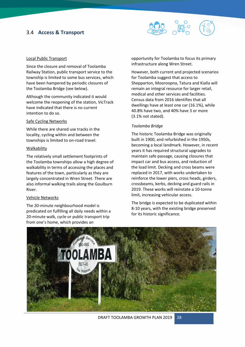
Access & Transport 3.4
Local Public Transport
Since the closure and removal of Toolamba Railway Station, public transport service to the township is limited to some bus services, which have been hampered by periodic closures of the Toolamba Bridge (see below).
Although the community indicated it would welcome the reopening of the station, VicTrack have indicated that there is no current intention to do so.
Safe Cycling Networks
While there are shared use tracks in the locality, cycling within and between the townships is limited to on-road travel.
Walkability
The relatively small settlement footprints of the Toolamba townships allow a high degree of walkability in terms of accessing the places and features of the town, particularly as they are largely concentrated in Wren Street. There are also informal walking trails along the Goulburn River.
Vehicle Networks
The 20-minute neighbourhood model is predicated on fulfilling all daily needs within a 20-minute walk, cycle or public transport trip from one’s home, which provides an
opportunity for Toolamba to focus its primary infrastructure along Wren Street.
However, both current and projected scenarios for Toolamba suggest that access to Shepparton, Mooroopna, Tatura and Kialla will remain an integral resource for larger retail, medical and other services and facilities. Census data from 2016 identifies that all dwellings have at least one car (16.1%), while 40.8% have two, and 40% have 3 or more (3.1% not stated).
Toolamba Bridge
The historic Toolamba Bridge was originally built in 1900, and refurbished in the 1950s, becoming a local landmark. However, in recent years it has required structural upgrades to maintain safe passage, causing closures that impact car and bus access, and reduction of the load limit. Decking and cross beams were replaced in 2017, with works undertaken to reinforce the lower piers, cross heads, girders, crossbeams, kerbs, decking and guard rails in 2019. These works will reinstate a 10-tonne limit, increasing vehicular access.
The bridge is expected to be duplicated within 8-10 years, with the existing bridge preserved for its historic significance.
DRAFT TOOLAMBA GROWTH PLAN 2019 29
Employment 3.5
Local Employment Opportunities
Toolamba is primarily an agricultural district with activities such as fruit and vegetable growing, dairy farming, cropping, wool growing, and cattle & sheep grazing.
The Toolamba Primary School and Kindergarten provide the largest proportion of jobs in Toolamba. The general store and hotel support limited retail and commercial employment opportunities.
Connections within the region
Many local residents work in nearby towns such as Kialla, Tatura, Mooroopna and Shepparton.
Services 3.6
Local shopping centres
Toolamba contains a general store and hotel on Wren Street. This local activity centre has the long-term opportunity to expand and provide more community based commercial activities.
Local health facilities and services
There are no medical facilities in Toolamba. Residents travel to nearby townships, Mooroopna or Shepparton.
Education 3.7
Local schools
Toolamba Primary School and Kindergarten were constructed in 2012, following the destruction of the previous weatherboard buildings by fire in 2010. It is designed to serve a catchment of approximately 2,000 houses and should continue to provide adequate capacity for the local community into the future.
Secondary education will continue to be provided by schools outside of the townships.
Lifelong learning opportunities
Higher education is provided by a number of tertiary institutions based in Shepparton, including La Trobe University and GOTAFE. A large number of online courses are available and 88.1% of dwellings have internet access.
DRAFT TOOLAMBA GROWTH PLAN 2019 30
DRAFT TOOLAMBA GROWTH PLAN 2019 31
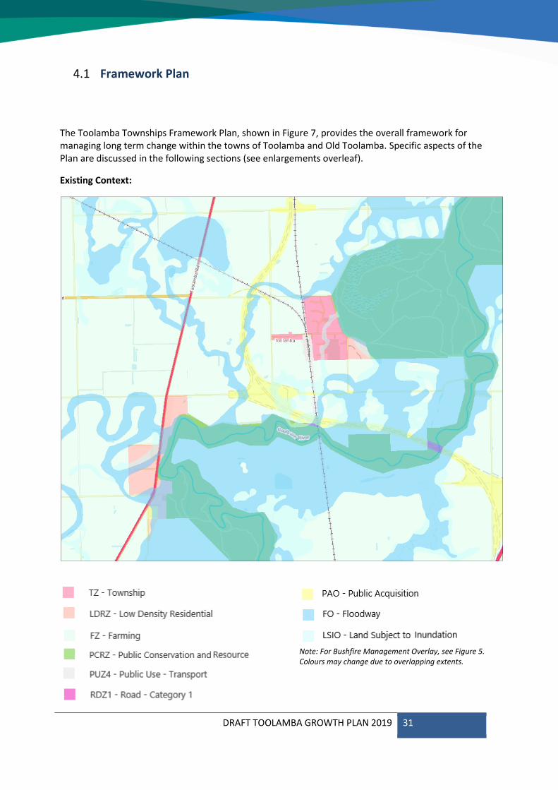
Framework Plan4.1
The Toolamba Townships Framework Plan, shown in Figure 7, provides the overall framework for managing long term change within the towns of Toolamba and Old Toolamba. Specific aspects of the Plan are discussed in the following sections (see enlargements overleaf).
Existing Context:
Note: For Bushfire Management Overlay, see Figure 5. Colours may change due to overlapping extents.
DRAFT TOOLAMBA GROWTH PLAN 2019 32
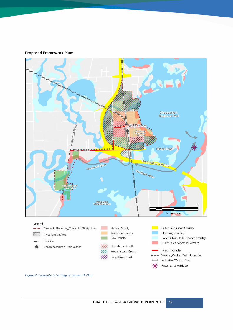
Proposed Framework Plan:
Figure 7. Toolamba's Strategic Framework Plan
DRAFT TOOLAMBA GROWTH PLAN 2019 33
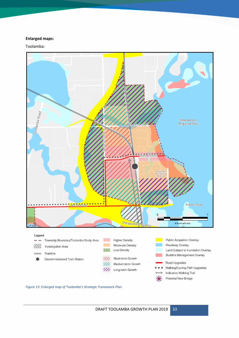
Enlarged maps:
Toolamba:
Figure 13: Enlarged map of Toolamba’s Strategic Framework Plan
DRAFT TOOLAMBA GROWTH PLAN 2019 34
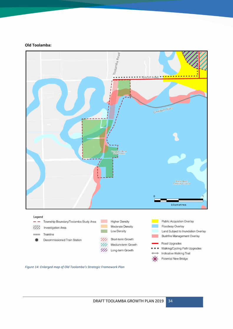
Old Toolamba:
Figure 14: Enlarged map of Old Toolamba’s Strategic Framework Plan

DRAFT TOOLAMBA GROWTH PLAN 2019 35
Housing 4.1
A greater diversity of housing types and sizes will improve the provision of sustainable housing options in the townships, which will benefit residents by allowing relocation to accommodate changing needs without losing social networks and support. This will be particularly beneficial if household size continues to decrease and as the population ages.
Toolamba’s green and spacious feel are key contributors to the character of the townships, so future estates should maintain proportional setbacks and generous landscaping.
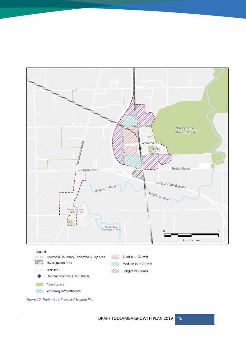
While Toolamba is not well suited to the provision of ‘Affordable Housing’, largely due to its distance from services and employment opportunities, and deficiency of public transport, residential development should be carefully staged to maintain affordability. Areas close to Wren Street should be developed first to maintain town cohesion.
Continued growth may require assessment of traffic movement and impacts, both before and after construction of the Bypass. Future estates should consider access to surrounding roads to minimise traffic utilising Wren Street, particularly in proximity to the Kindergarten and Primary School, as well as evacuation in the event of flooding or fire.
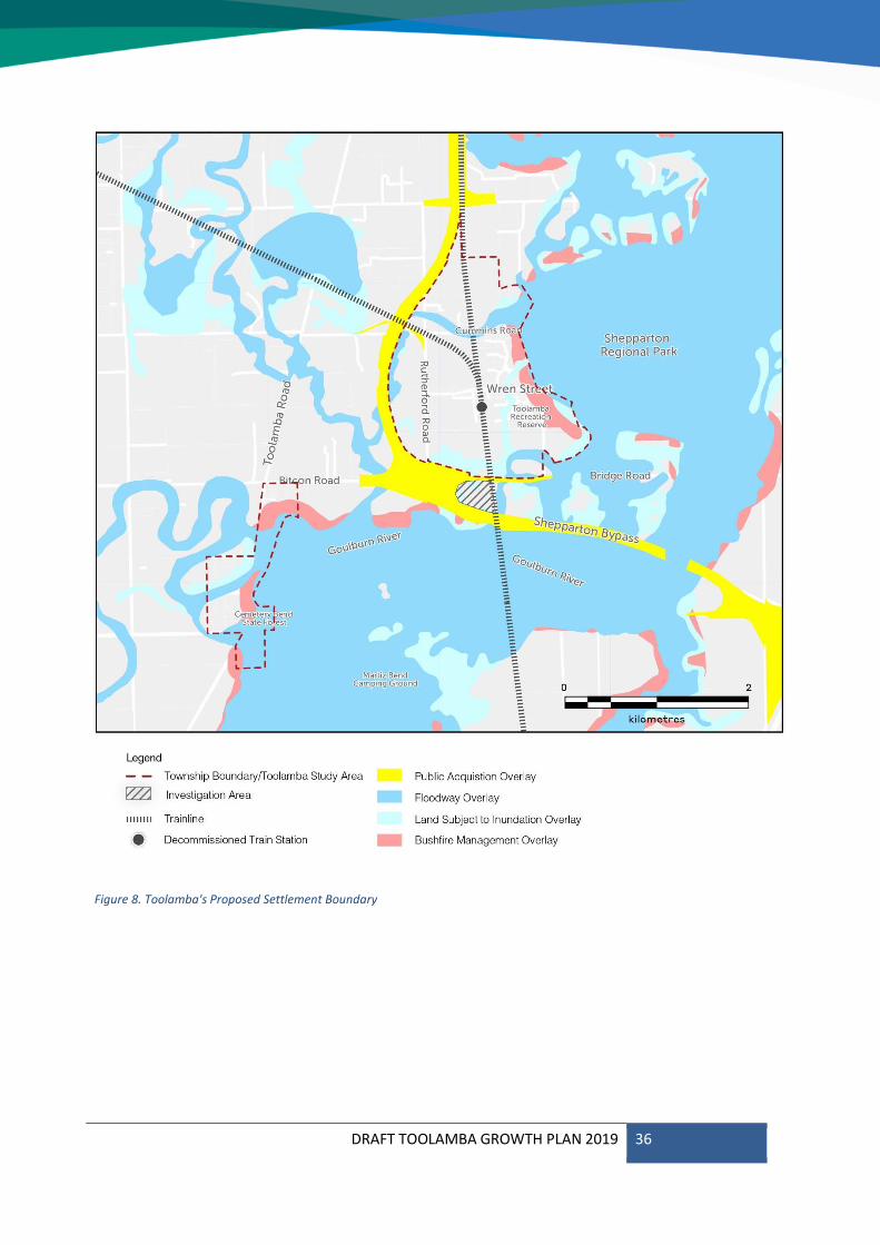
Revised Settlement Boundary
The proposed settlement boundary for the Toolamba townships is provided in Figure 8, below.
The revised settlement boundary reflects the Future Direction (see Section 1.3) and Principles for Growth (see Section 3.1), aiming for resilient and sustainable development to support the growing community.
The Shepparton Regional Park and the proposed Goulburn Valley Highway Shepparton Bypass form obvious barriers to expansion of Toolamba Township. Residential development will need to take noise and other amenity issues from the Bypass into consideration. Setbacks and vegetation screening will be important design considerations for properties adjacent to the Bypass.
Toolamba’s commercial and community services are concentrated along Wren Street, so the revised settlement boundary consolidates development within walking and cycling distance of these facilities.
A parcel of land to the south of the Public Acquisition Overlay for the Goulbourn Valley Highway Shepparton Bypass has been designated as an investigation area, with potential to be rezoned to accommodate residential or commercial uses depending on future requirements.
DRAFT TOOLAMBA GROWTH PLAN 2019 36
Figure 8. Toolamba's Proposed Settlement Boundary
DRAFT TOOLAMBA GROWTH PLAN 2019 37
Housing diversity
The existing settlement pattern concentrates smaller lots on or within close proximity of Wren Street, with larger lots further out.
Potential growth in the Toolamba townships needs to reflect this model and provide diversity in lot sizes to encourage a range of housing types and cater to the needs of all residents.
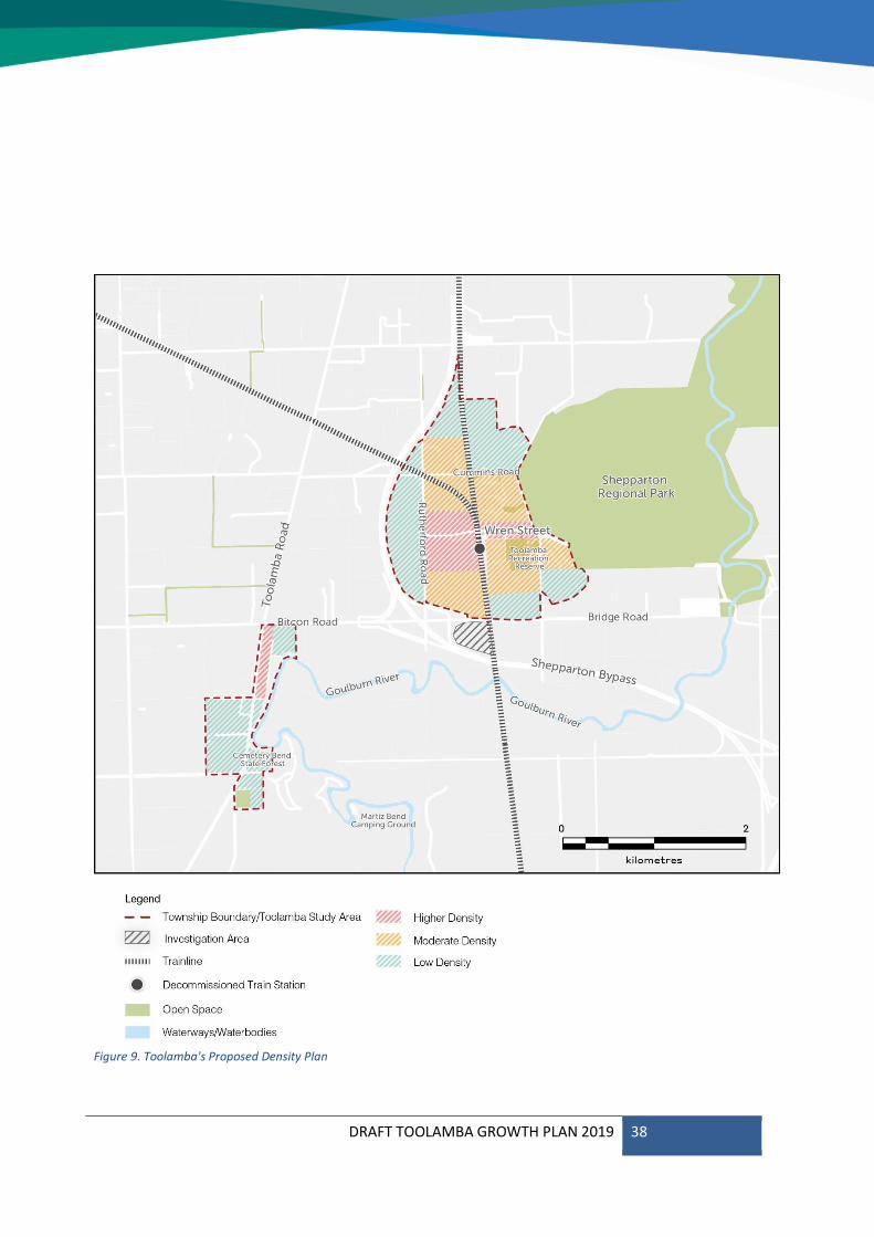
The indicative densities of the areas within the Toolamba townships are provided in Figure 9. This outcome provides three residential classifications based on density:
Higher density lots of 800-2,000m²;
Moderate density lots of 2,000-4,000m²;
Low density lots greater than 4,000m².
The Plan positions areas of higher density close to Wren Street, so that smaller households can enjoy easy access to facilities and services.
The provision of a variety of housing types and models is recommended, although the generous setbacks and landscaping that contribute to the local neighbourhood character and atmosphere should be maintained.
Ability to age in place
The provision of affordable housing and diversity of housing type in the Toolamba townships will provide greater ability for residents to age in place, which may involve downsizing from the more typical 3+ bedroom homes to smaller homes offering easy access to facilities in Wren Street.
Affordable Housing options
Potential growth in the town will require new areas to be developed for residential land incrementally. Staging the release of residential land will promote housing affordability by ensuring an adequate supply of housing to the market. New residential land supply will be provided over a 30-year period, ensuring the township develops naturally from the activity centre out. It also allows for the provision of sewer infrastructure to be brought into town via Wren Street.
DRAFT TOOLAMBA GROWTH PLAN 2019 38
Figure 9. Toolamba's Proposed Density Plan
DRAFT TOOLAMBA GROWTH PLAN 2019 39
Safe streets and spaces
The character of the Toolamba townships is described as having a ‘rural feel’ by many residents, which is closely associated with quiet streets and feelings of safety.
Relevant built form elements include generous lot sizes, setbacks and the use of canopy trees in landscaping. These elements combine to ensure the built form does not dominate the streetscape.
Feedback makes it clear that the preference is for this rural feel to prevail even as the population grows. Elements that contribute to the preferred character, such as generous setbacks, canopy trees and landscaping are to be included as requirements for new development.
Housing Actions
Rezone land intended to be serviced by reticulated sewerage identified for higher density development within the proposed settlement boundary to provide for lots between 800 – 2,000 square metres (refer to Appendix A);
Rezone land intended to be serviced by reticulated sewerage and identified for moderate density development within the proposed settlement boundary to the provide for lots between 2,000 – 4,000 square metres;
Rezone land not intended to be serviced by reticulated sewerage and identified for low density development within the proposed settlement boundary to provide for lots 4,000 square metres or more;
Adopt the staging associated with the Growth Plan to provide land for residential development incrementally to ensure natural and affordable growth.
Direct growth away from areas with environmental constraints, such as mapped hazards or dense vegetation cover.
Advocate for increased public transport services between Toolamba and surrounding centres such as Tatura, Mooroopna and Shepparton to allow residents a greater ability to age in place.
Ensure rezoning provides for development that respects the preferred character of the area, including but not limited to generous setbacks and landscaping.
DRAFT TOOLAMBA GROWTH PLAN 2019 40
Figure 10. Toolamba's Proposed Staging Plan

DRAFT TOOLAMBA GROWTH PLAN 2019 41
Open Space4.2
Natural features surrounding Toolamba form geographic constraints to development. However, they also contribute to growth demand, as they create scenic landscapes and opportunities for recreation in open space, which is part of what makes the Toolamba townships a desirable place to live.
Conservation of the natural environment and open spaces is dealt with through the application of the settlement boundary. However, protecting and enhancing canopy trees, vegetation and landscaping within the settlement boundary is also considered as part of the design guidelines for managing future growth and respecting the Toolamba townships’ rural landscape and character.
The interface between rural residential and existing or potential agricultural land uses should be considered with any new allotments along Toolamba Road and on the edges of the settlement boundary. Larger setbacks and landscaped open spaces will provide screening and buffers between these land uses and contribute to the rural feel and natural landscape that characterises the Toolamba townships.
Local playgrounds, parks and community gardens
Provision of local pocket parks and areas of passive open space will be required alongside new residential development. Larger proposals, such as the PSP area, must incorporate areas of open space within the subdivision.
Colaura Gardens and the Toolamba Recreation Reserve are and will continue to be the townships’ major open space assets. They will
require ongoing investment and improvement in community infrastructure, as the population grows.
Green streets and spaces
The Toolamba townships are characterised in part by consistently generous setbacks and the planting/retention of canopy trees. These elements combine to ensure the built form does not dominate the streetscape and instead creates green, leafy streets. This contributes to what the community refer to as the ‘rural feel’ of the area, and feedback makes it clear that the preference is for this rural feel to prevail.
All new development, regardless of lot size, should also respond to the preferred neighbourhood character by ensuring adequate permeable space is provided for landscaping and the planting of canopy trees. The species used in landscaping should be the same or similar to indigenous and native species found in the local area, and where possible sourced locally.
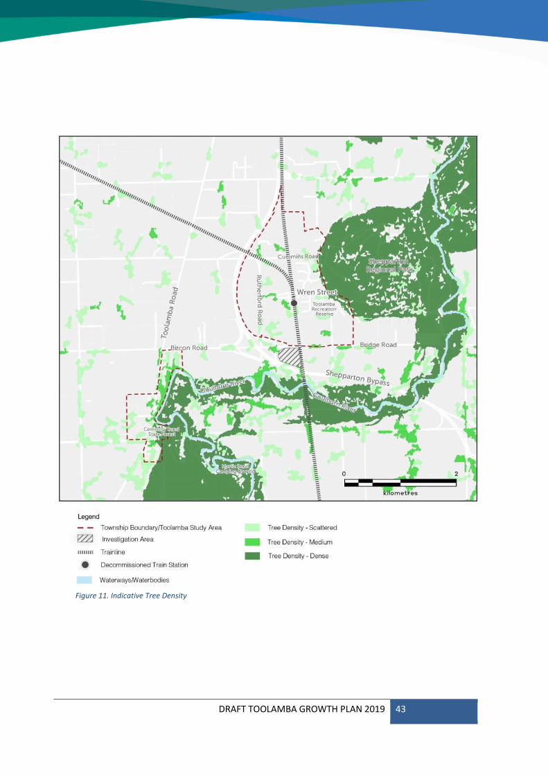
In areas of new development, the protection of existing vegetation should be prioritised to ensure individual species and patches of vegetation continue to contribute to the landscape and neighbourhood character. An indication of tree density in the Toolamba townships alongside the proposed settlement boundary is provided in Figure, 11, which shows the most heavily vegetated areas are associated with the Goulburn River and Shepparton Regional Park.
Council should undertake further strategic work to investigate the viability of a Vegetation Protection Overlay (VPO) or similar, to protect these areas of vegetation from development.
DRAFT TOOLAMBA GROWTH PLAN 2019 42
Sport and recreation facilities
The Toolamba Recreation Reserve will continue to offer a wealth of active recreation opportunities for residents. As the population grows, there will be an increase in demand on these existing facilities. Maintenance of existing facilities should be an ongoing priority, with future upgrades and additions being provided within the existing recreation reserve, in line with population increase.
Open Space Actions
Periodically assess the provision of open space for passive and active recreation, ensuring new facilities are planned for and provided as the population grows
Ensure new development includes street trees and landscaping that include a diversity of indigenous and native species.
Ensure new development avoids removal of native vegetation and mature trees as far as possible, and minimises removal where it becomes necessary.
Undertake further strategic work to investigate the application of a Vegetation Protection Overlay (VPO) to protect significant areas of vegetation.
Maintain and enhance the Toolamba Recreation Reserve to meet the active recreation needs of the growing population.
Ensure the establishment of any new active recreation uses are complementary to the existing services and are provided within the existing recreation reserve where possible.
DRAFT TOOLAMBA GROWTH PLAN 2019 43
Figure 11. Indicative Tree Density
DRAFT TOOLAMBA GROWTH PLAN 2019 44
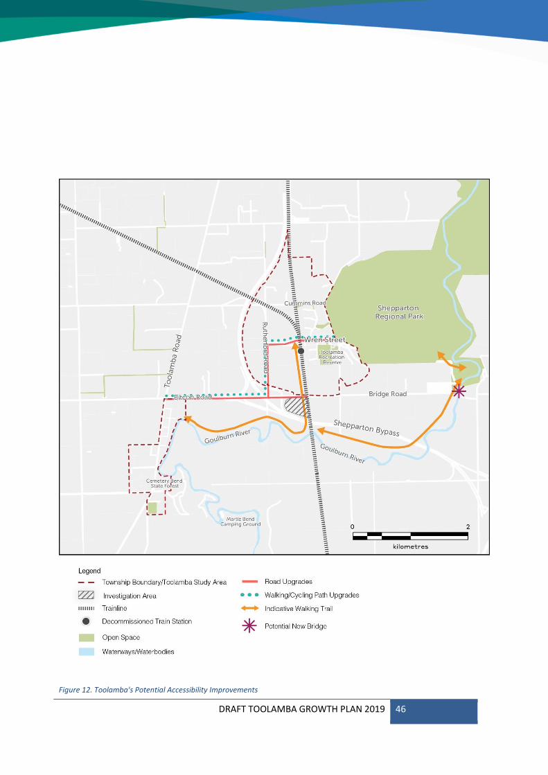
Access & Transport 4.3
Walking and cycling are important modes of transport in Toolamba, enabling social connections and accessibility for all age groups. Shared use, off-road paths should be incorporated into future residential development.
At time of writing, Greater Shepparton City Council is preparing to update the Cycling Strategy 2013-2017 which will examine the potential to connect Toolamba to the wider municipal network, including the State Government’s Strategic Cycling Corridors.
Motor vehicles will continue to allow access to the wider municipality to provide amenities and opportunities not available due to the townships’ size, particularly following the construction of the Goulburn Valley Highway Shepparton Bypass. Traffic movements and impacts will require periodic assessment; increased utilisation of Wren Street as a thoroughfare may require infrastructure upgrades and traffic management measures, to ensure safe passage for pedestrians. This is especially important in the area adjacent to the school, due to its restricted access.
Local Public Transport
Increased public bus services would improve the opportunities for residents, particularly those with limited mobility and school-aged children, to access a wider range of services and facilities outside of Toolamba.
The new Toolamba Bridge should be designed to allow for bus access. Additionally, bus routes should be negotiated to provide direct links to Mooroopna, Shepparton and public and private secondary schools.
Passenger rail services would also greatly improve accessibility of the Toolamba townships to Shepparton and Melbourne. The State Government has expressed interest in selling the former station land.
Safe Cycling Networks
It is recommended that the development of a new walking and cycling trail be conducted in two stages. The first stage will follow the below proposed alignment, ensuring that a public track is provided for the community in the shorter term, as it was identified as a high priority in the Toolamba Community Plan (2016).
The second stage will connect the stage 1 trail to Old Toolamba following the community alignment. This will allow for a complete looped trail that provides an important link between the two townships. This stage of the trail will require negotiation with Parks Victoria and licenses to be obtained, such as a land tenure agreement for Greater Shepparton Council. The trail connection into Old Toolamba will also be subject to negotiations, as land connecting the township and the Goulburn River Parkland may be currently occupied.
A long-term opportunity to then link this trail along the Goulburn River further north, via the Toolamba Bridge, should be considered as the town grows.
Walkability
The expansion of the townships’ settlement boundary is based on an 800-metre (or 10 minute) walkable catchment from the local activity centre on Wren Street. Smaller lot sizes are concentrated in closer proximity to the centre to enhance walkability.
Dedicated trails along the railway line and the Goulburn River would connect new development to the local centre and provide a permeable pedestrian network that encourages walkability.
DRAFT TOOLAMBA GROWTH PLAN 2019 45
Vehicle Network
The Shepparton Bypass will improve accessibility between Toolamba and surrounding areas. It is expected to increase visitation and growth to the Toolamba townships.
Although the section of the Shepparton Bypass which crosses the study area has not been designated a completion timeframe, it is important to understand how the bypass site can be planned and designed well to ensure accessibility within the townships is not lost.
Upgrades to several roads should also be considered in order to improve the accessibility of the town. Bitcon Road, Rutherford Road and Wren Street were identified as potential roads for upgrade, as they will enhance accessibility to Toolamba and provide an augmented connection to Old Toolamba.
Toolamba Bridge
The future provision of a new bridge over the Goulburn River to replace the Toolamba Bridge will greatly improve the road access into Toolamba. The new bridge will have an increased road limit and will allow for more goods and services to be provided to the township as it would renew freight truck access from large regional centres through the Goulburn Valley Highway.
Providing access for larger vehicles, including buses, will also open opportunities for the local community to access alternative school catchments and cut down significantly on travel time for students.
Access & Transport Actions
Collaborate with VicRoads on the Shepparton Bypass project to ensure maximum accessibility is maintained between Toolamba and Old Toolamba, including walking and cycling.
Advocate for pedestrian and cyclist trails and trail crossings associated with the Shepparton Bypass.
Collaborate with VicRoads for the provision of a new bridge over the Goulburn River to provide for heavy vehicle (including bus) access.
Negotiate new and additional bus routes between Toolamba and nearby towns.
Advocate to Department of Transport and VLine for long-term passenger rail services to be reinstated in Toolamba.
Ensure that any future development future-proofs the capacity to deliver passenger rail services in the long-term.
Maintain existing pedestrian and cyclist trails and provide new off-road trails in key locations.
Potential improvements to the road network include:
Bitcon Road: o Road widening o Lane markings o Walking and cycling path provision
Rutherford Road: o Road widening o Signage o Lane markings o Walking and cycling path provision
Wren Street: o Separated footpaths o Lane markings o Kerb, channel and guttering
upgrade o Walking and cycling path provision
DRAFT TOOLAMBA GROWTH PLAN 2019 46
Figure 12. Toolamba's Potential Accessibility Improvements
DRAFT TOOLAMBA GROWTH PLAN 2019 47
Employment 4.4
Local Employment Opportunities
Employment opportunities in Toolamba are limited. Additional employment opportunities may be procured if commercial development occurs along Wren Street, and if demand grows for Primary School and Kindergarten classes. The widespread availability of internet services offers potential for new complementary uses and home-based businesses.
There may be an opportunity for employment-generating land uses that do not undermine the function of Wren Street provided in other locations and subject to further investigation.
Connections within the region
Wren Street, Toolamba is a small, local activity centre that services the immediate needs of the townships’ residents.
Employment opportunities are found in the larger activity centres such as Tatura, Mooroopna and Shepparton. As the townships grow, expansion of public transport modes and routes will provide access to wider opportunities.
Employment Actions
Council to investigate the opportunity for employment-generating uses to be provided in other locations within the township, without undermining Wren Street as the town centre.
DRAFT TOOLAMBA GROWTH PLAN 2019 48
Services4.5
Local shopping centres
Future incremental commercial and community development should occur along Wren Street to further enhance its role and function as a local activity centre within Toolamba.
In supporting Wren Street as the ‘main street’ of Toolamba, public realm improvements should also be implemented through better footpaths, formalised car parking and street furniture where appropriate.
Local health facilities and services
As the population grows, there will be a greater demand for health-based facilities in the Toolamba townships. Council may also augment or increase provision of health services from the Toolamba Community Centre relative to population.
Health services will continue to be provided by the surrounding localities of Tatura, Mooroopna and Shepparton. In the short-term, improved public transport access to these centres will be prioritised, while advocating for the introduction of health facilities in Toolamba may become feasible in the longer term.
The need for additional commercial and community facilities will need to be monitored.
Infrastructure
Reticulated sewerage infrastructure would be a benefit for the town and its residents, offering much more flexibility and diversity in housing options and land uses.
Much of Toolamba’s proposed future development will be dependent on the provision of reticulated sewerage services, to enable lots of less than 4,000sqm.
It is anticipated that further discussion with Goulburn Valley Water would be required to understand the staging and cost implications for the town.
Services Actions
Promote provision of local shops along Wren Street in concert with potential population growth to meet more of the townships’ immediate needs.
Work closely with developers to provide reticulated sewerage.
Assess and provide more community services and facilities as the population grows.
DRAFT TOOLAMBA GROWTH PLAN 2019 49
Education4.6
Local schools
The Toolamba Primary School and Kindergarten currently have ample capacity, but will be periodically assessed to cater for the growing population, while demand for secondary schools will continue to be fulfilled by surrounding localities.
Lifelong learning opportunities
Opportunities for higher education such as university and TAFE will continue to be available in Shepparton. Rather than seek to establish these uses permanently in Toolamba, provision of public transport to these centres from Toolamba should be prioritised.
The primary school and community centre will continue to be the core social assets of the townships which provide opportunity for learning and educational experiences.
Education Actions
Augment and invest in the Toolamba Primary School and Toolamba Community Facility commensurate to population growth and demand for education.
Explore opportunities to provide training and educational programs at the primary school and/or community centre.
DRAFT TOOLAMBA GROWTH PLAN 2019 50
DRAFT TOOLAMBA GROWTH PLAN 2019 51
Action Plan5.1
The Action Plan builds on the strategies and recommendations discussed throughout the Toolamba Growth Plan. It presents a consolidated Action Plan (as provided in this section) to realise the vision and objectives for the Toolamba Townships.
The Action Plan will be used as a guide to identify Council’s role, responsibilities and priority for each recommended action.
Council’s Role
Greater Shepparton City Council will play different roles in the implementation of the Structure Plan. These will include the roles of Planner, Provider, Advocate, Facilitator, and Regulator. A description of these various roles is provided below.
Planner – in relation to its urban and social planning responsibilities
Provider – in relation to local responsibilities
Advocate – representing community needs and interests to Federal and State Governments and the private sector
Facilitator – working closely with developers, landowners, residents and businesses
Regulator – ensuring that built form, infrastructure and other elements of the environment meet town planning, building, transport and public health regulations.
Action Plan
The table overleaf outlines the actions to be taken to manage Toolamba’s growth over the coming decades, consolidating the objectives and actions discussed in the preceding chapters.
The following order applies to the priorities:
High (0 - 5 years)
Medium (6 - 15 years)
Low (16 - 30 years)
Ongoing (regularly)
DRAFT TOOLAMBA GROWTH PLAN 2019 52
ACTION COUNCIL ROLE PRIORITY
General
1
Implement the Toolamba Growth Plan through a Planning Scheme Amendment.
Planner High
1a. Amend the Municipal Strategic Statement (MSS) at Clause 21.02 (Key Influences and Issues) to incorporate the Toolamba Townships Growth Plan and highlight the vision and principles for managing growth.
Planner High
1b. Adopt the proposed settlement boundary and staging plan by incorporating the Toolamba Townships Growth Plan to the Greater Shepparton Planning Scheme.
Planner High
1c. Rezone land within the proposed settlement boundary to achieve residential development at the desired densities.
Planner High
1d. Prepare a schedule to the Design and Development Overlay (DDO) to implement Design Guidelines to guide development in Toolamba.
Planner
High
Open Space
2 Schedule and conduct periodic assessment of the provision of open space for passive and active recreation, ensuring open space is planned for and provided as the population grows.
Planner Ongoing
3 Ensure new development includes street trees and landscaping. Regulator Ongoing
4 Undertake further strategic work to investigate the potential for the application of a Vegetation Protection Overlay (VPO) that protects dense medium and scattered tree densities from development.
Planner Medium
Access & Transport
5 Advocate to VicRoads:
For locally accessible pedestrian and cyclist trails.
For a new bridge to replace the Toolamba bridge, provide for heavy vehicle (including bus) access.
Throughout the Shepparton Bypass project to ensure accessibility is maintained between Toolamba and Old Toolamba.
Advocate Ongoing
6 Advocate to PTV for more local bus services between Toolamba and Shepparton-Mooroopna.
Advocate Medium
7 Provide new, off-road trails in key locations (such as along the Goulburn River) to better connect Toolamba and Old Toolamba.
Planner/Provider/ Facilitator
Medium
8 Improve the local road and footpath network at key locations, including:
Bitcon Road
Rutherford Road
Wren Street
Provider Ongoing
DRAFT TOOLAMBA GROWTH PLAN 2019 53
9 Develop a gateway and signage plan to enhance the town centre’s entrances on Bridge Road and Rutherford Road in order to create an improved welcoming first impression, and improve wayfinding and directional signage throughout the town.
Provider/Facilitator (with Community)
Employment
10 Investigate the long-term potential for a second hub of employment-generating land uses in another location that does not detract from Wren Street as the primary activity centre.
Planner Low
Services
11 Work closely with developers to introduce reticulated sewerage Partner / Facilitator
High
12 Monitor and provide more community services and facilities as the population grows.
Advocate/Partner/ Facilitator
Ongoing
Education
13 Augment and invest in the Toolamba Primary School and Toolamba Community Facility commensurate to population growth and demand for education.
Advocate
(Department of Education)
Ongoing
14 Explore opportunities to provide training and educational programs at the primary school and/or community centre.
Facilitator Medium
DRAFT TOOLAMBA GROWTH PLAN 2019 54
Planning Scheme 5.2
This section identifies the recommended planning scheme controls to implement the Toolamba Townships Growth Plan.
Local content in zone schedules will include provisions to preserve the rural and landscape character of Toolamba, the need for increased housing diversity, and other provisions as identified.
Zoning
Changes to the Zones will be implemented based on the Growth Plan and the need to appropriately accommodate future growth and improvements to the town.
The following is recommended:
Rezone land (refer to Appendix A) identified for higher density to allow for the development of new, smaller residential lots within the town centre.
Rezone land (refer to Appendix A) identified for moderate density to encourage a mix of lot sizes and provide an increased supply of developable residential land.
Rezone land (refer to Appendix A) identified for lower density to ensure a long-term outlook for residential growth over the next 30 years.
The LDRZ already provides different minimum lot size requirements depending on whether the land is serviced by reticulated sewerage infrastructure.
Expansion of the Township Zone (TZ) along and close to Wren Street will allow for an increased offering of commercial and retail services within the town centre.
Overlays
Design & Development Overlay
It is recommended that a Design and Development Overlay (DDO) be applied to all land identified for growth as shown in Figure 8.
The DDO is the most appropriate tool in the Planning Scheme to manage built form outcomes. It provides the mechanism to include the key elements of the residential design principles that relate to residential development in Toolamba.
The DDO should contain the design principles relevant to development on private land, including building heights, setbacks, and material requirements. The schedule will be tailored to provide objectives, strategies and decision guidelines for Council that have been crafted specifically for Toolamba.
The DDO schedule should contain:
Design objectives derived from each of the principles.
General design guidelines.
A section for each aspect of development on private land that will outline design guidelines for:
o Built form (e.g. height and setbacks)
o Landscape o Lighting and safety o Access and movement.
The Development Plan Overlay (DPO) has also been considered, however, this is an unwieldy tool that requires additional work in the preparation of development plans and direct landowner involvement. The DPO exempts a proposal from third party appeal rights for proposals that comply with the development plan once it is approved.
Vegetation Protection Overlay
It is recommended that Council undertake further strategic work to apply a Vegetation Protection Overlay (VPO) to all land identified as having dense, moderate and scattered tree density as shown on Figure 11.
The VPO will ensure the protection of significant specimens and clusters of trees in these areas and minimise the loss of

DRAFT TOOLAMBA GROWTH PLAN 2019 55
vegetation resulting from development. It provides further environmental controls that will help maintain the habitats of native vegetation in the face of future growth.
The VPO schedule would contain:
A statement of the nature and significance of the vegetation to be protected.
The vegetation protection objectives to be achieved
General decision guidelines.
DRAFT TOOLAMBA GROWTH PLAN 2019 56
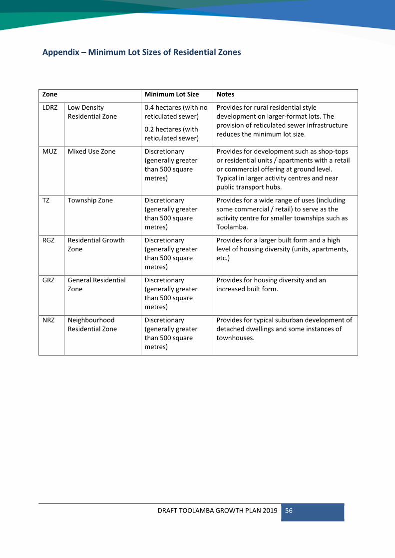
Appendix – Minimum Lot Sizes of Residential Zones
Zone Minimum Lot Size Notes
LDRZ Low Density Residential Zone
0.4 hectares (with no reticulated sewer)
0.2 hectares (with reticulated sewer)
Provides for rural residential style development on larger-format lots. The provision of reticulated sewer infrastructure reduces the minimum lot size.
MUZ Mixed Use Zone Discretionary (generally greater than 500 square metres)
Provides for development such as shop-tops or residential units / apartments with a retail or commercial offering at ground level. Typical in larger activity centres and near public transport hubs.
TZ Township Zone Discretionary (generally greater than 500 square metres)
Provides for a wide range of uses (including some commercial / retail) to serve as the activity centre for smaller townships such as Toolamba.
RGZ Residential Growth Zone
Discretionary (generally greater than 500 square metres)
Provides for a larger built form and a high level of housing diversity (units, apartments, etc.)
GRZ General Residential Zone
Discretionary (generally greater than 500 square metres)
Provides for housing diversity and an increased built form.
NRZ Neighbourhood Residential Zone
Discretionary (generally greater than 500 square metres)
Provides for typical suburban development of detached dwellings and some instances of townhouses.