Embed Size (px)
Citation preview
Green Burn Wind Farm ABO Wind UK Ltd
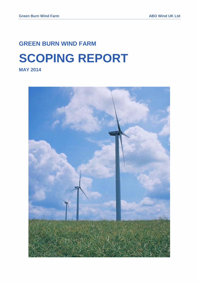
GREEN BURN WIND FARM
SCOPING REPORT MAY 2014
Green Burn Wind Farm ABO Wind UK Ltd
i
Contents
1 Introduction ................................................................................................................................................. 1
1.1 The Need for EIA ............................................................................................................................... 1
1.2 Purpose of EIA Scoping ..................................................................................................................... 1
1.3 ABO Wind UK Ltd .............................................................................................................................. 2
1.4 EIA Team ........................................................................................................................................... 2
1.5 Scoping Method ................................................................................................................................. 2
1.6 Scoping Report Structure .................................................................................................................. 3
2 Project Description ..................................................................................................................................... 3
2.1 The Proposed Site ............................................................................................................................. 3
2.2 The Proposed Scheme ...................................................................................................................... 4
3 Proposed Approach to the EIA ................................................................................................................... 6
3.1 Assessment of Significance of Environmental Effects ...................................................................... 6
3.2 Mitigation............................................................................................................................................ 6
4 Proposed EIA Method Statements ............................................................................................................. 7
4.1 Proposed Approach ........................................................................................................................... 7
4.2 Planning Policy .................................................................................................................................. 7
4.3 Landscape and Visual Amenity ......................................................................................................... 8
4.4 Ornithology....................................................................................................................................... 14
4.5 Ecology ............................................................................................................................................ 21
4.6 Noise ................................................................................................................................................ 28
4.7 Cultural Heritage .............................................................................................................................. 29
4.8 Aviation and Telecommunications ................................................................................................... 33
4.9 Geology, Hydrology and Hydrogeology ........................................................................................... 33
4.10 Transport.......................................................................................................................................... 38
4.11 Air & Climate .................................................................................................................................... 39
5 Consultation .............................................................................................................................................. 41
5.1 Scoping Consultations ..................................................................................................................... 41
5.2 Responses to Scoping ..................................................................................................................... 41
5.3 Public Consultation .......................................................................................................................... 41
Figures
Figure 1 Site Location Plan
Figure 2 ZTV for 120M Blade Tip Height
Green Burn Wind Farm ABO Wind UK Ltd
1
1 INTRODUCTION
1.1 The Need for EIA
ABO Wind UK Ltd (ABO Wind) wishes to develop Green Burn Wind Farm (the development), on land
at Blackhall Farm and Shieldrum Farm approximately 11 km north of Blairgowrie and 11km north west
of Alyth, in Perth & Kinross. ABO Wind’s current plans envisage a scheme of up to 14 turbines with a
generating capacity of up to 26 megawatts (MW). The location of the development site is shown in
Figure 1.
ABO Wind acknowledges that the proposed development would constitute a ‘Major’ development
under the terms of the Town and Country Planning (Hierarchy of Development) (Scotland)
Regulations 2009 and that the proposed development constitutes a Schedule 2 development under
the Environmental Impact Assessment (Scotland) Regulations 1999 as amended (EIA Regulations).
As ABO Wind considers that the proposed development, by virtue of factors such as its size, nature or
location, is likely to have significant effects on the environment, an EIA of the proposed development
will be required. ABO Wind therefore does not propose to seek a Screening Opinion for the scheme
from Perth & Kinross Council.
In order to establish the scope of the EIA for the development, ABO Wind has committed to early
engagement with Perth & Kinross Council as part of its “Pre-Application Consultation”, holding
meetings with officers from the Council in October 2013 and again in March 2014.
ABO Wind is also aware that in accordance with the Planning etc. (Scotland) Act 2006 and associated
regulations, applicants have a statutory duty to undertake pre-application consultation with respect to
certain types of development including all major applications, applications contrary to the
Development Plan and, those requiring an Environmental Impact Assessment. On this basis, a
programme of formal Pre-Application Consultation will be undertaken and a Design and Access
Statement will be submitted to Perth and Kinross Council for determination.
With input from a team of experienced environmental consultants, preliminary site investigations, ABO
Wind has undertaken a scoping study and prepared a Scoping Report to accompany a request to
Perth & Kinross Council to adopt a Scoping Opinion as to the required approach to the EIA and the
content of the Environmental Statement (ES).
1.2 Purpose of EIA Scoping
The purpose of EIA is to identify the aspects of the environment likely to be significantly affected by
the development. EIA scoping is an early stage in the EIA process and is designed to identify the
environmental issues to be investigated during the EIA. The results of consultations and information
gathered in support of this aim must be taken into account. The European Commission’s Guidance on
EIA Scoping advises that the benefits of EIA scoping include:
It helps focus resources on the important issues for decision-making and avoids wasted effort on
issues of little relevance;
It helps ensure that the environmental information provides a balanced view and is not burdened
with irrelevant information;
It stimulates early consultation between the developer and the competent authority, with
environmental authorities, other interested parties and the public, about the project and its
environmental impacts;
It helps effective planning, management and resourcing of the environmental studies;
It should identify alternatives to the proposed project and mitigating measures which ought to be
considered by the developer;
It reduces the risk of delays caused by requests for further information after submission of the
development consent application and the environmental information; and
Green Burn Wind Farm ABO Wind UK Ltd
2
It reduces the risk of disagreement about methods of impact assessment (baseline surveys,
methods of prediction of change and evaluation criteria) after submission of the environmental
information.
The purpose of this Scoping Report is to assist the Council in adopting a Scoping Opinion as to the
scope of the EIA to be undertaken, the methods to be adopted in undertaking the EIA and the content
of the ES.
1.3 ABO Wind UK Ltd
ABO Wind is an international renewable energy company with 250 staff operating in eight countries,
including Ireland and the UK, where it has been active for eight years. Globally, it has over 400 MW
wind energy on-line and a further 1,000 MW in the pipeline. In Scotland, ABO Wind has currently one
operational, three-turbine, scheme at Lairg, Sutherland, and has several other projects in
development in The Highland Council area, in Perth & Kinross, Argyll & Bute, North Lanarkshire and
the Scottish Borders.
ABO Wind adopts a development model that encourages community investment and involvement in
the projects it develops. Potential development sites are evaluated against a set of criteria, including
potential yield, grid connection and environmental constraints. ABO Wind considers that sites in areas
already developed for wind energy can offer opportunities for new wind energy development with
reduced environmental impact.
1.4 EIA Team
The following independent environmental consultants were appointed to the Green Burn Wind Farm
project, with their respective roles in preparing this Scoping Report indicated:
Direct Ecology – Ornithology and Ecology;
SLR Consulting Ltd – Landscape and Visual Amenity; Geology, Hydrology and Hydrogeology;
Northlight Heritage – Archaeology and Cultural Heritage;
Golder Associates (UK) Ltd – Noise, and Air and Climate;
Aviatica Ltd – Aviation and Telecommunications; and
WYG Environment Planning Transport Ltd (WYG) – Transport.
ABO Wind staff will provide input in relation to Planning, Socio-economics, EIA co-ordination and ES
preparation.
1.5 Scoping Method
The EIA Scoping Report has been prepared taking into account the relevant guidance and advice, as
follows:
European Commission, Guidance on EIA Scoping, June 2001;
Institute for Environmental Management & Assessment, Guidelines for Environmental Impact
Assessment, 2004;
Institute of Ecology and Environmental Management (IEEM), Guidelines for Ecological Impact
Assessment in the United Kingdom, 2006.
Scottish Executive, Planning Advice Note 1/2013: Environmental Impact Assessment, 2013;
Scottish Natural Heritage, A Handbook on Environmental Impact Assessment, 2009; and
Scottish Natural Heritage, Guidelines on the Environmental Impacts of Windfarms and Small Scale
Hydroelectric Schemes, 2002.
Green Burn Wind Farm ABO Wind UK Ltd
3
This has involved initial discussions with SNH, desk review of published information and initial field
survey in respect of ornithology, ecology, landscape and visual, archaeology and cultural heritage,
and hydrology, hydrogeology and geology, and transport issues.
1.6 Scoping Report Structure
The remainder of this Scoping Report is structured as follows:
Section 2 provides information about the development, including its construction, operational and
decommissioning phases;
Section 3 discusses the proposed approach to be adopted for undertaking the EIA;
Section 4 sets out detailed method statements for each of the environmental technical topic areas
which it is proposed to address in the EIA, as follows:
Planning Policy Overview
Landscape & Visual Amenity;
Ornithology;
Ecology;
Noise;
Cultural Heritage;
Geology, Hydrology, Hydrogeology and Geology;
Traffic;
Aviation and Telecommunications.
Socio-economics, Recreation and Tourism;
Shadow flicker; and,
Air and Climate.
Section 5 invites consultees to comment on the Scoping Report.
2 PROJECT DESCRIPTION
2.1 The Proposed Site
The Green Burn Wind Farm site is located within the local authority area administered by Perth &
Kinross Council, on land at Black Hall farm and Shieldrum Farm approximately 11 km north of
Blairgowrie and 11 km north-west of Alyth. The site centre is approximately at National Grid co-
ordinates NO 315871 755635; the site location is shown in Figure 1. The site extends to
approximately 266.3 ha and lies across the two summits of Hill of Kingseat (389 m Above Ordnance
Datum (AOD)) and Saebeg (381 m AOD). The site generally slopes down to the north-west and
comprises two adjacent parcels of land which are separated by the C446 road. This road connects
the A93 with the outskirts of Alyth, and passes through the development area generally in a north-
west/south-east direction.
Black Water flows in a southerly direction to the west of the site, joining the River Echt approximately
5 km south of the site. The A93 passes west of the site in a north/south direction, broadly following
the alignment of Black Water.
Part of the site to the east of Seabeg falls within the Dun Moss and Forest of Alyth Mires Special Area
of Conservation (SAC) and Site of Special Scientific Interest (SSSI). The qualifying interest of this
site is its raised bog. There are no statutorily designated sites of cultural heritage, geological or
landscape value within the application site. The Cairngorms National Park lies approximately 8 km to
Green Burn Wind Farm ABO Wind UK Ltd
4
the north and Craighall Rattray (Gardens and Designed Landscapes) lies approximately 7.5 km south
of the site.
Within the wider area those sites designated for their nature conservation importance within 10 km of
the site include the following:
Forest of Clunie Special protection Area (SPA)/ Site of Special Scientific Interest (SSSI);
River Tay and Craighill Gorge Special Area of Conservation (SAC); and
Drumore Loch and Den of Alyth Site of Special Scientific Interest (SSSI).
An initial desk based study has identified that there are cultural heritage interests (remains of farming
activity) on site, believed to be of local significance. Within the wider area further, evidence of past
farming activity is also evident and a number of designated features have been identified, including a
small number of historic buildings and Scheduled Ancient Monuments (SAMs). Cultural heritage
resources are discussed further in Section 4.7.
The principal current land use of the site is sheep grazing. British Geological Survey mapping
indicates that the site is largely underlain by glacial till deposits. Two small areas of peat deposits are
evident towards the east of the site; the rockhead is understood to be shallow across the site.
The site is located in a ‘Broad Area of Search’ for wind energy developments as identified in Perth
and Kinross Council’s Supplementary Planning Guidance for Wind Energy Proposals in Perth and
Kinross, 2005. This Supplementary Guidance is supportive ‘in principle’ of onshore wind energy
developments in Broad Areas of Search, subject to detailed consideration against planning policy and
guidance.
2.2 The Proposed Scheme
A development of up to 14 turbines is being considered with an expected operational life of 25 years.
On completion of the operational life of the wind farm, the turbines would be decommissioned and the
site restored to a standard required by Perth & Kinross Council. Turbine size envisaged is up to a
maximum of 120 m to blade tip height. A control building would also be required.
Detailed method statements for the construction, operational and decommissioning phases of the
wind farm would be prepared for the approval of the Council. The duration of the construction and
decommissioning phases is each expected to be up to 12 months per process.
Access to the proposed wind farm would be taken from the C446 via one new access junction to the
southern section of the site. The northern section of the site would be taken via the existing access
junction to the property at the Corb, which would be upgraded. Both new and upgraded existing on-
site access tracks will be formed using rock material to be obtained from borrow pits that would be
established on site where possible. Concrete required for formation of turbine bases would be
batched off-site. A temporary construction compound would be established on-site.
The grid connection for the proposed development would be via the proposed control building.
Metering and switchgear will be contained within this building. The connection between the control
building and the wider grid will be subject to a separate consent procedure.
The precise form of development and route for the connection may not be available at the time of
planning submission for the wind farm. ABO Wind will seek to describe, as far as can be reasonably
expected, the likely significant environmental effects of the proposed connection to allow decision
makers to consider these effects in combination with the wind energy development. It is currently
anticipated that a 33kV overhead line or buried cable connection to a substation at Coupar Angus
some 18km from the site will be possible.
Cabling on site would be underground. The grid connection would not form part of the planning
application.
The site layout and design will be refined during the EIA process. Delivery of plant and construction
materials to the development would be via the C446 via Alyth. This would require access by heavy

Green Burn Wind Farm ABO Wind UK Ltd
5
goods vehicles (HGVs), light goods vehicles (LGVs) and private cars in varying profiles throughout
the construction, operational and decommissioning phases of the project. To accommodate the
delivery of abnormal indivisible loads (AILs), including the turbine components, localised
improvements to the road network may be required.
Green Burn Wind Farm ABO Wind UK Ltd
6
3 PROPOSED APPROACH TO THE EIA
The EIA will be undertaken in accordance with relevant guidance and best practice, which will be set
out as appropriate for each technical topic area. A common overall approach to the assessment of
significance of environmental effects will be adopted based on matrices assessing ‘Receptor
Importance/Sensitivity’ and ‘Magnitude of Change’. This is described in more detail below.
3.1 Assessment of Significance of Environmental Effects
The overarching principle that would be applied to the evaluation of significance of environmental
effects will be based on the definition of the sensitivity of a receptor, and the magnitude of change to
which the receptor will be subjected. Where appropriate, professional judgement will contribute to
establishing the likelihood of significant environmental effects arising from the development. The
generic approach to be adopted is as follows:
Identify those potential receptors that could be affected by these environmental effects;
Identify the importance of the receptor and its sensitivity to change, using a range of levels
comprising ‘Negligible’, ‘Low’, ‘Medium’ and ‘High’; and
Identify the magnitude of change predicted to be experienced by the receptor, using a range of
levels comprising ‘Negligible’, ‘Low’, ‘Medium’ and ‘High’; and Identify the level of significance of
the environmental effect by comparing the importance and sensitivity of the receptor with the
magnitude of predicted change, as illustrated in Table 3.1.
Table 3.1: Levels of Environmental Effects
Magnitude of Change
Receptor Sensitivity High Medium Low Negligible
High Major Major Moderate None
Medium Major Moderate Minor None
Low Moderate Minor Slight None
Negligible None None None None
In this manner, effects assessed as being ‘Major’ are considered to be a significant effect as referred
to in Schedule 3 of the EIA Regulations. Effects assessed as ‘Moderate’, ‘Minor’, ‘Slight’ or a
gradation between these, are considered not significant. Where either magnitude of change or
receptor sensitivity is assessed as ‘Negligible’, no environmental effect is predicted.
In some circumstances, where ‘Moderate’ effects are predicted, professional judgment will be applied
to ensure that the potential for significant effects arising has been thoroughly considered. This
approach will be adapted for each of the technical topics considered in an EIA to reflect differing
circumstances encountered and alternative levels of value attributed to those receptors identified.
Adapted approaches, where proposed, are discussed in the relevant method statements in Section 4
of this Scoping Report.
The assessment of effects will consider the direct, indirect, secondary and cumulative effects, the
duration of the effect (e.g. permanent or temporary and short, medium or long-term), and the
sensitivity of receptor. The legislative requirements associated with the presence of particular features
will also be considered.
3.2 Mitigation
The requirement for, and nature of, mitigation measures to address predicted adverse effects will be
discussed with relevant stakeholders as appropriate. The agreed mitigation measures will be taken
into account in the assessment of residual effects. All mitigation measures considered in the EIA will
have been agreed by ABO Wind and incorporated into the project design and delivery methods. They
therefore represent committed, not speculative, measures that can form the basis of planning
Green Burn Wind Farm ABO Wind UK Ltd
7
conditions or other environmental management plans to be the subject of further agreement with the
Planning Authority or other statutory agencies.
4 PROPOSED EIA METHOD STATEMENTS
4.1 Proposed Approach
The environmental topic areas that will be assessed in the EIA are discussed below. The proposed
scope of the technical assessments and the methodologies to be adopted are set out for each
technical topic area.
4.2 Planning Policy
4.2.1 Planning Policy Framework
The planning policy context for wind energy development will be described in the ES.
Decisions on planning applications must be made in accordance with the development plan unless
material considerations indicate otherwise, as required under the Planning Acts. The development
plan pertaining to the Green Burn Wind Farm site comprises:
a Strategic Development Plan ‘TAYplan’ jointly prepared by Perth and Kinross, Dundee, Angus
and Fife Councils that was approved in June 2012;
The Perth and Kinross Council Local Development Plan was adopted in February 2014 and covers
the whole Perth and Kinross Council area, with the exception of those areas covered by the
National Parks.
Sections 25 and 37(2) of the Town and Country Planning (Scotland) Act 1997 (as amended) require
that planning decisions be made in accordance with the development plan unless material
considerations indicate otherwise. With respect to the Green Burn Wind Farm project, such material
considerations would include, amongst others:
The policy and targets of the Scottish Government, themselves set within the strategic framework
of UK Government policy, with respect to a range of matters, most relevant being renewable
energy and climate change;
The national planning policy framework for Scotland, set out in the National Planning Framework
for Scotland 2 (NPF2), the consolidated Scottish Planning Policy document and the various
Planning Advice Notes published by the Scottish Government;
The Supplementary Planning Guidance for Wind Energy Proposals in Perth and Kinross, which
was approved by the Perth and Kinross Council in May 2005; and
The likely significant environmental effects of the proposed project, as reported in the ES.
4.2.2 Supplementary Planning Guidance for Onshore Wind Energy Proposals
The Supplementary Planning Guidance for Wind Energy Proposals in Perth and Kinross (SPG) was
approved in May 2005 and precedes the publication of the consolidated SPP in 2010. The
Supplementary Guidance provides a spatial framework with areas mapped across the Perth and
Kinross Council administrative area where wind energy developments may be acceptable ‘Broad
Areas of Search’ contained within Diagram 1 of the SPG. The SPG indicates that the Green Burn
Wind Farm site lies within a Broad Area of Search where appropriate proposals are likely to be
supported subject to the detailed development plan and supplementary guidance considerations. At
the time of issue of this request for Scoping, it is understood that Perth and Kinross Council are in the
process of revising this SPG.
4.2.3 Policy Appraisal
All relevant policies will be summarised in tabular format and will include a ‘project response’ to each,
such as how the project design has taken account of policy requirements, with cross referencing to
the relevant sections of the ES where policy issues are discussed in more detail.
Green Burn Wind Farm ABO Wind UK Ltd
8
The policy appraisal to be undertaken does not provide an assessment of the degree to which the
proposed Green Burn Wind Farm is in accordance with planning policy and other material
considerations. This will be set out in a Planning Support Statement that will accompany the planning
application, but which would not form part of the ES.
4.3 Landscape and Visual Amenity
A Landscape and Visual Impact Assessment (LVIA) will be undertaken to assess the potential
landscape and visual effects of the proposed development, as well as identifying potential mitigation
measures. The assessment will also address potential cumulative landscape and visual effects.
LVIA includes a combination of objective and subjective judgements and it is therefore important that
a structured and consistent approach is used which accords with current guidance.
In summary, the LVIA will:
Be carried out in accordance with established current methodology and guidance;
Focus on valued landscape and visual resources (at national, regional and local levels); and
Present the findings supported by appropriate figures and illustrations.
4.3.1 Site Context
The proposed site lies within the Highland Summits and Plateaux Landscape Character Type (LCT)
identified in the Tayside Landscape Character Assessment (No 122 for SNH 1999).
The key landscape and visual considerations for the proposed Green Burn Wind Farm are anticipated
to be:
Its relationship to the landform of the site and adjacent area, including its appearance in the
context of the Highlands Boundary Fault Line from the lower lying and smaller scale landscape
character areas to the south
Its relationship to the existing Drumderg Wind Farm and other adjacent wind farm applications;
Its potentially visual impacts (on its own and cumulatively) on Cairngorms National Park receptors;
and
Its potentially significant visual impacts (on its own and cumulatively) on residential receptors.
It is noted that according to Diagram 1 of the Supplementary Planning Guidance for Wind Energy in
Perth and Kinross (May 2005), the proposed site is within the ‘Broad Area of Search’, where
Commercial wind energy developments are supported if they are consistent with the Council’s
detailed Policy Guidelines. It is understood that the SPG is being updated but not yet published.
4.3.2 Consultations
In order to inform the LVIA, consultation will take place with Perth and Kinross Council (PKC),
Scottish Natural Heritage (SNH) and the Cairngorms National Park Authority (CNPA), following the
issue of the Scoping Report in order to identify relevant baseline information and key issues or
concerns that these organisations may wish to raise at the early stages of the assessment.
Agreement on the number and location of viewpoints to be included in the detailed assessment, the
list of cumulative sites to be considered and the overall approach and methodology for the
assessment will be agreed with these consultees.
Additionally, public exhibitions will be held and consultation with the local community councils will be
carried out.
4.3.3 Study Area
In accordance with current best practice, the study area for the LVIA would extend to 35km from the
outer turbines. This is based on the distance of Zone of Theoretical Visibility (ZTV) as recommended
Green Burn Wind Farm ABO Wind UK Ltd
9
in the SNH Visual Representation of Windfarms Good Practice Guidance (2006) for wind turbines
over 101 m.
In accordance with SNH’s cumulative best practice guidance (Assessing the Cumulative Impact of
Onshore Wind Energy Developments, SNH March 2012), a base plan will be produced showing the
location of all operating, consented, and undetermined applications for wind farms and proposals for
wind farms subject to scoping requests in the public domain within a 60 km search area of the
proposed Green Burn turbines. For the detailed cumulative assessment the study area will
encompass 35 km radius from the outer turbines of the proposed Green Burn Wind Farm.
4.3.4 Sensitive Receptors
The assessment of landscape and visual effects will be informed by a series of viewpoints. The
viewpoints will be selected to cover points of specific importance including: recognised viewpoints,
designated landscapes, settlements, important routes and attractions, and to inform the likely extent
of significant landscape and/or visual effects arising from the proposed Green Burn Wind Farm. A
variety of landscape character types and points from different directions, distances and elevations will
also be represented in the selected views.
An initial list of candidate viewpoint locations occurring within the Zone of Theoretical Visibility (ZTV)
for a preliminary layout of the proposed turbines has been prepared and is provided in this document
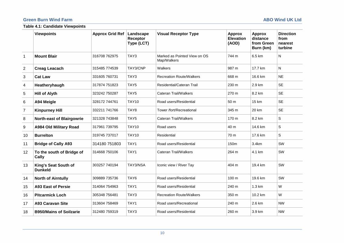
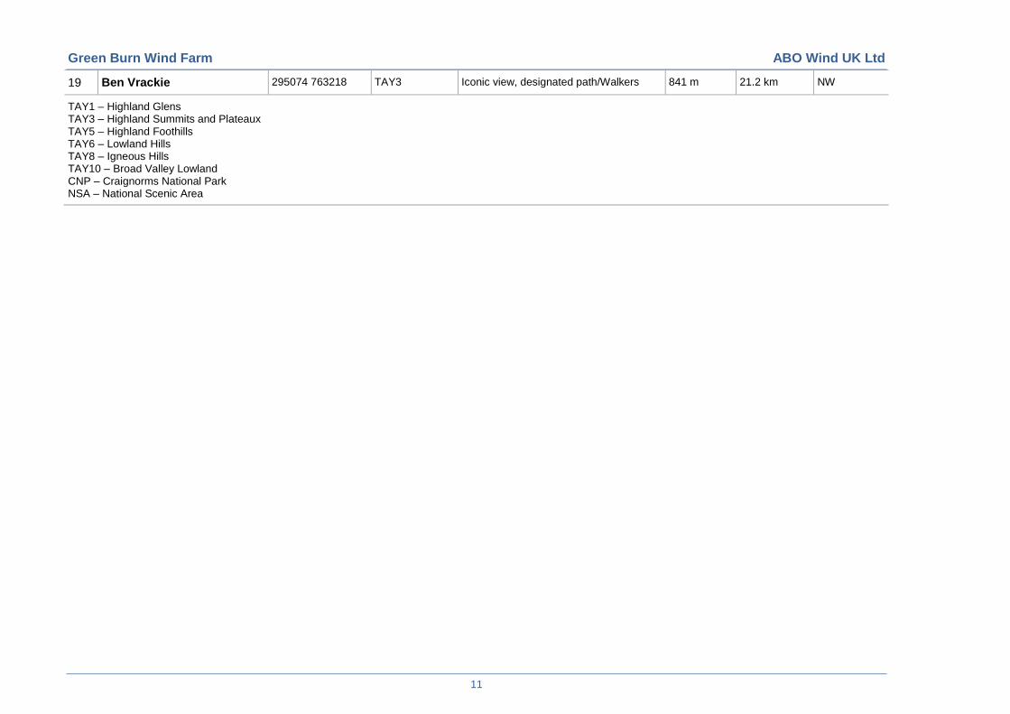
for comment from consultees. The viewpoints are listed in Table 4.1, which provides information on
their location, distance from the proposed development and landscape and visual receptors which
they represent. The location of these viewpoints is shown on Figure 2.
Green Burn Wind Farm ABO Wind UK Ltd
10
Table 4.1: Candidate Viewpoints
Viewpoints Approx Grid Ref Landscape Receptor Type (LCT)
Visual Receptor Type Approx Elevation (AOD)
Approx distance from Green Burn (km)
Direction from nearest turbine
1 Mount Blair 316708 762975 TAY3 Marked as Pointed View on OS Map/Walkers
744 m 6.5 km N
2 Creag Leacach 315485 774539 TAY3/CNP Walkers 987 m 17.7 km N
3 Cat Law 331605 760731 TAY3 Recreation Route/Walkers 668 m 16.6 km NE
4 Heatheryhaugh 317874 751823 TAY5 Residential/Cateran Trail 230 m 2.9 km SE
5 Hill of Alyth 323242 750287 TAY5 Cateran Trail/Walkers 270 m 8.2 km SE
6 A94 Meigle 328172 744761 TAY10 Road users/Residential 50 m 15 km SE
7 Kinpurney Hill 332211 741766 TAY8 Tower /fort/Recreational 345 m 20 km SE
8 North-east of Blairgowrie 321328 743848 TAY5 Cateran Trail/Walkers 170 m 8.2 km S
9 A984 Old Military Road 317961 739795 TAY10 Road users 40 m 14.6 km S
10 Burrelton 319745 737017 TAY10 Residential 70 m 17.6 km S
11 Bridge of Cally A93 314180 751803 TAY1 Road users/Residential 150m 3.4km SW
12 To the south of Bridge of Cally
314668 750106 TAY1 Cateran Trail/Walkers 264 m 4.1 km SW
13 King's Seat South of Dunkeld
303257 740194 TAY3/NSA Iconic view / River Tay 404 m 19.4 km SW
14 North of Airntully 309889 735736 TAY6 Road users/Residential 100 m 19.6 km SW
15 A93 East of Persie 314064 754963 TAY1 Road users/Residential 240 m 1.3 km W
16 Pitcarmick Loch 305348 756481 TAY3 Recreation Route/Walkers 350 m 10.2 km W
17 A93 Caravan Site 313604 758469 TAY1 Road users/Recreational 240 m 2.6 km NW
18 B950/Mains of Soilzarie 312480 759319 TAY3 Road users/Residential 260 m 3.9 km NW
Green Burn Wind Farm ABO Wind UK Ltd
11
19 Ben Vrackie 295074 763218 TAY3 Iconic view, designated path/Walkers 841 m 21.2 km NW
TAY1 – Highland Glens TAY3 – Highland Summits and Plateaux TAY5 – Highland Foothills TAY6 – Lowland Hills TAY8 – Igneous Hills TAY10 – Broad Valley Lowland CNP – Craignorms National Park NSA – National Scenic Area
Green Burn Wind Farm ABO Wind UK Ltd
12
4.3.5 Survey Methods
The LVIA will be prepared in accordance with the following key guidance:
Guidelines for Landscape and Visual Impact Assessment (GLVIA), third edition, Landscape
Institute and the Institute of Environmental Assessment (2013);
Landscape Character Assessment Guidance for England and Scotland, Department of
Landscape University of Sheffield and Land Use Consultants (2002), on behalf of The
Countryside Agency and Scottish Natural Heritage;
Visual Representation of Windfarms Good Practice Guidance, Horner and MacLennan and
Envision, Report No: FO3 AA 308/2 (2006), on behalf of Scottish Natural Heritage, Scottish
Renewables Forum and Scottish Society of Directors of Planning;
Photography and Photomontage in Landscape and Visual Impact Assessment ,Landscape
Institute, Advice Note 01/11 (2011); and
Assessing the Cumulative Impact of Onshore Wind Energy Developments, Scottish Natural
Heritage (March 2012).
The LVIA will be produced to a standard suitable for submission within an Environmental
Statement, in accordance with The Environmental Impact Assessment (Scotland) Regulations
1999.
4.3.6 Desktop and Field Survey
The following sources will be consulted in order to compile the baseline information:
SNH’s Landscape Character Assessments for the study area;
SNH’s Strategic Locational Guidance for Onshore Wind Farms in Respect of the Natural
Heritage (2009);
The relevant development plans’ landscape policies and guidance;
Historic Scotland’s Gardens and Designed Landscapes Inventory;
Ordnance Survey Maps;
Aerial photography; and
Consultation with PKC, SNH and CNPA.
Following approval of the final site layout for the proposed turbines and all related infrastructure
and production of draft wirelines, the study area will be visited during periods of reasonably fine
and clear weather, to verify landscape and visual receptors and related effects. The assessment
will be carried out on the basis of clear visibility.
A description of the existing landscape and visual context of the 35 km radius study area will be
prepared against which to judge the potential effects of the development. This will comprise a
written section for the ES LVIA based on desk study, initial field work to confirm receptor
locations, as well as any data confirmed during consultations.
Once the viewpoint locations are agreed with PKC, SNH and CNPA, photography will be carried
out during suitable weather conditions and in accordance with SNH guidelines.
Green Burn Wind Farm ABO Wind UK Ltd
13
4.3.7 Design Optimisation/Mitigation
A landscape design analysis process will be undertaken to identify the key landscape and visual
characteristics of the site and immediately surrounding area. These will be recorded and
mapped. Consideration will also be given to other environmental and technical constraints to
refine the wind farm composition with the aim of achieving the ‘best environmental fit’ to the
landscape of the area.
The key way in which potentially adverse effects on landscape and/or visual amenity can be
addressed is through attention to the design and layout of the proposed turbines and all related
infrastructure including on-site access tracks or borrow pits. Therefore the preliminary wind farm
layout will be subject to detailed further design during the assessment process in order to
achieve the ‘best environmental fit’.
4.3.8 Impact Assessment
The detailed LVIA will describe the predicted visibility of the proposed wind farm within the 35
km radius study area and assess the residual impacts arising from the optimised design on
landscape and visual receptors.
The sensitivity of the landscape will be assessed by combining susceptibility of the landscape to
change with landscape value. Sensitivity will be defined as high, medium, or low based on
professional interpretation of a combination of parameters. Viewpoint sensitivity will be
assessed by combining susceptibility of the visual receptor with the value of the particular view.
Sensitivity will be defined as high, medium or low based on interpretation of a combination of
parameters.
The magnitude of change arising from the proposed development for landscape and visual
receptors will be described as substantial, moderate, slight or negligible, based on the
interpretation of a combination of largely quantifiable parameters, such as size or scale,
geographical extent as well as duration and reversibility.
The additional parameters which will be used to evaluate magnitude of cumulative change are:
The number of wind farm developments visible;
Distance to each of the wind farms;
Direction in which each of the other wind farms is located relative to the viewpoint; and
Increase in the proportion of view occupied by turbines.
Simultaneous and sequential visibility will be identified, with cumulative sequential analysis
carried out for up to five key routes in the study area, likely to include the Cateran Trail
recreational walking route, the A93 and A984 (both Old Military Roads).
Effects will be assessed as major, moderate, minor or none by considering viewpoint or
landscape sensitivity and predicted magnitude of change, with major and major/moderate
effects being considered significant effects in terms of the EIA regulations.
Following completion of a second stage of field survey with draft wirelines, the detailed
assessment work will be carried out to identify the sensitivity of receptors, anticipated magnitude
of change and significance of residual landscape and visual impacts. The potential impacts of
construction and operational aspects of the development, including ancillary elements will also
be assessed.
4.3.9 Residential Visual Amenity Assessment
There is no published guidance on the method and best practice for conducting an appraisal of
impacts on residential visual amenity of dwellings in the locality of a wind farm. The report will
therefore be based on SLR’s previous experience of undertaking such studies with the
conclusions based on professional judgement, underpinned by the visual information including
wirelines, photography, aerial photos and site visits from publicly accessible locations.
Green Burn Wind Farm ABO Wind UK Ltd
14
A detailed assessment of potential visual impacts on residential properties within a 3 km study
area (measured from the nearest proposed turbines) will be undertaken as follows:
A ZTV based on DTM data will be produced for the study area and locations of all residential
properties within the ZTV will be identified and allocated a reference number;
Photography/wirelines and detailed description of existing and proposed views from outside
residential properties or groups of properties within the ZTV will be prepared. (Note: this will
not include views from within properties or photomontages); and
Where possible, objective data will be used, e.g. distance and direction of view to turbines
from residential properties, or groups of properties and percentage of available view
occupied by proposed wind farm to assess the nature of the anticipated change to residential
visual amenity.
4.4 Ornithology
4.4.1 Introduction
The aim of the ornithology assessment is to consider the likely use of the proposed Green Burn
Wind Farm site by sensitive bird species and evaluate the potential for habitat loss, disturbance,
displacement and collisions with turbines. The Environmental Impact Assessment (EIA) will look
at the potential impact of the operation of the wind farm on birds particularly through blade
strike.
All ornithological survey methods and assessment at Green Burn are based on Scottish Natural
Heritage (SNH) Guidance. SNH has produced a range of documents relating to the assessment
of bird/wind farm interactions as identified below and these will be used in the ornithological
assessment:
SNH (2010a) Survey methods for Use in Assessment of the Impacts of Onshore Wind Farms
on Bird Communities. SNH Advisory Services and National Strategy;
SNH (2005) Cumulative Effect of Wind Farms. Guidance Note, March 2005;
SNH (2006) Assessing Significance of Impacts from Onshore Windfarms on Birds Outhwith
Designated Areas. SNH, Battleby;
Band, W., Madders, M. & Whtifield, D.P. (2007). Developing Field and Analytical Methods to
Assess Avian Collision at Windfarms. In: Birds and Windfarms;
SNH (2009) Monitoring the Impact of Onshore Wind Farms on Birds. Guidance Note,
January 2009; and
SNH (2010b) Use of Avoidance Rates in the SNH Wind Farm Collision Risk Model. SNH
Avoidance Rate Information and Guidance Note.
4.4.2 Site Context
The 2.66 km² site is centred on two rounded hills at 380m, split by a minor road. To the north is
Saebeg with Hill of Kingseat to the south. Dun Moss and Alyth Forest Mires SAC/SSSI is to the
east of Saebeg. The ground gently slopes away down to Blackhall Farm in the west at 268m
and Green Burn in the east at 330 m. The Green Burn drains the site to the east and a number
of artificial drains enter the Drumturn Burn to the west, which eventually enters the Black Water.
Apart from Blackhall Farmhouse there are no buildings on the site. Shieldrum Farm and its
buildings are several hundred metres beyond the proposed Green Burn Wind Farm site
boundary and the cottage at Corb is 650 m beyond.
4.4.3 Study Area and Desk Study
In order to obtain all relevant ecological information and to help to refine the proposed scope of
the EIA the following organisations and sources of information will be consulted:
Royal Society for the Protection of Birds (RSPB);
Green Burn Wind Farm ABO Wind UK Ltd
15
Scottish Natural Heritage (SNH);
Scottish Environment Protection Agency (SEPA);
Drumderg Wind Farm Environmental Statement;
Welton of Creuchies Environmental Statement; and
Land Owners/Tenants.
Correspondence with SNH, along with other consultees where necessary, will continue from
scoping throughout the duration of the EIA in order to keep these key consultees informed.
An initial desk study for information regarding protected sites for birds and species presence
has been undertaken. The ornithology desk study area comprised a search of designated sites
and sensitive bird species as detailed in Table 4.2. The following data sources were consulted:
Sitelink (www.snh.org.uk/snhi);
SNH initial scoping response;
Land Owner;
Drumderg Wind Farm Environmental Statement; and
Welton of Creuchies Environmental Statement.
Table 4.2: Criteria for Search of Designated Sites of Ornithological Interest
Designation and Description Resolution for Search Site
Internationally designated sites (Ramsar, Special Protection Area (SPA), Special Area of Conservation (SAC) and Important Bird Area (IBA))
The Ramsar Convention on Wetlands of International Importance especially as Waterfowl Habitat. SPAs aim to protect the habitat of rare, threatened or migratory bird species. SACs aim to protect rare, endangered or vulnerable habitats and species. An IBA is an area recognized as being globally important habitat for the conservation of bird populations.
Within 20 km
Nationally designated sites (Site of Special Scientific Interest (SSSI), National Nature Reserve (NNR))
SSSIs are areas of land which have been notified and designated which are “of special interest by reason of any of its flora, fauna, or geological or physiographical features”. NNRs are areas of land set aside for nature, where the main purpose of management is the conservation of habitats and species of national and international significance. All NNRs are designated as at least one, and usually more, different types of protected area.
Within 2 km (more if the SSSI or NNR is partly designated for birds).
Locally designated sites (Local Nature Conservation Site (LNCS), Site of Interest for Nature Conservation (SINC), Wildlife Site (WS))
Local and district level non-statutory designations, often identified by Local Planning Authorities.
Within 2 km.
Breeding bird species Any bird species breeding within the development site and a 200 m buffer.
As per SNH Survey Guidance
Sensitive species – collision risk
As defined in SNH Guidance Within 200 m of rotor envelope
Green Burn Wind Farm ABO Wind UK Ltd
16
It is apparent that there are a number of breeding bird species present within the area. All wild
birds receive general protection to their nest and eggs under the Wildlife and Countryside Act
1981, as amended. Some species receive enhanced statutory protection due to their listing in
Schedule 1 of the Wildlife and Countryside Act 1981. It is an offence to disturb a Schedule 1
species while it is building a nest or is in, on, or near a nest containing eggs or young.
There are obligations within the Birds Directive 1979 relating both to protection of species and
maintenance of habitats. Birds on Annex 1 to the Birds Directive, regularly occurring migratory
species, and birds on Schedule 1 to the Wildlife & Countryside Act 1981 are recognised in
statute as requiring special conservation measures within the area that are of conservation
concern and should be assessed in detail during the EIA.
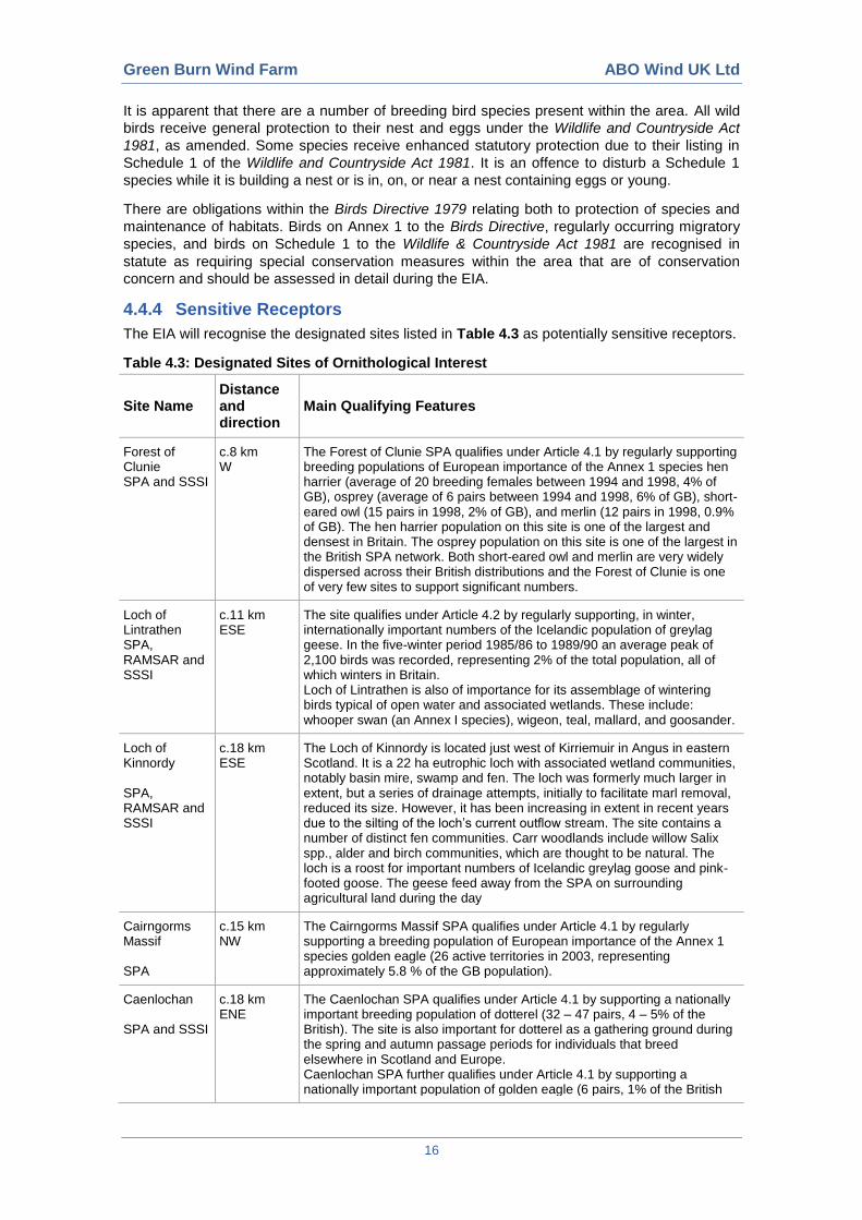
4.4.4 Sensitive Receptors
The EIA will recognise the designated sites listed in Table 4.3 as potentially sensitive receptors.
Table 4.3: Designated Sites of Ornithological Interest
Site Name Distance and direction
Main Qualifying Features
Forest of Clunie SPA and SSSI
c.8 km W
The Forest of Clunie SPA qualifies under Article 4.1 by regularly supporting breeding populations of European importance of the Annex 1 species hen harrier (average of 20 breeding females between 1994 and 1998, 4% of GB), osprey (average of 6 pairs between 1994 and 1998, 6% of GB), short-eared owl (15 pairs in 1998, 2% of GB), and merlin (12 pairs in 1998, 0.9% of GB). The hen harrier population on this site is one of the largest and densest in Britain. The osprey population on this site is one of the largest in the British SPA network. Both short-eared owl and merlin are very widely dispersed across their British distributions and the Forest of Clunie is one of very few sites to support significant numbers.
Loch of Lintrathen SPA, RAMSAR and SSSI
c.11 km ESE
The site qualifies under Article 4.2 by regularly supporting, in winter, internationally important numbers of the Icelandic population of greylag geese. In the five-winter period 1985/86 to 1989/90 an average peak of 2,100 birds was recorded, representing 2% of the total population, all of which winters in Britain. Loch of Lintrathen is also of importance for its assemblage of wintering birds typical of open water and associated wetlands. These include: whooper swan (an Annex I species), wigeon, teal, mallard, and goosander.
Loch of Kinnordy SPA, RAMSAR and SSSI
c.18 km ESE
The Loch of Kinnordy is located just west of Kirriemuir in Angus in eastern Scotland. It is a 22 ha eutrophic loch with associated wetland communities, notably basin mire, swamp and fen. The loch was formerly much larger in extent, but a series of drainage attempts, initially to facilitate marl removal, reduced its size. However, it has been increasing in extent in recent years due to the silting of the loch’s current outflow stream. The site contains a number of distinct fen communities. Carr woodlands include willow Salix spp., alder and birch communities, which are thought to be natural. The loch is a roost for important numbers of Icelandic greylag goose and pink-footed goose. The geese feed away from the SPA on surrounding agricultural land during the day
Cairngorms Massif SPA
c.15 km NW
The Cairngorms Massif SPA qualifies under Article 4.1 by regularly supporting a breeding population of European importance of the Annex 1 species golden eagle (26 active territories in 2003, representing approximately 5.8 % of the GB population).
Caenlochan SPA and SSSI
c.18 km ENE
The Caenlochan SPA qualifies under Article 4.1 by supporting a nationally important breeding population of dotterel (32 – 47 pairs, 4 – 5% of the British). The site is also important for dotterel as a gathering ground during the spring and autumn passage periods for individuals that breed elsewhere in Scotland and Europe. Caenlochan SPA further qualifies under Article 4.1 by supporting a nationally important population of golden eagle (6 pairs, 1% of the British
Green Burn Wind Farm ABO Wind UK Ltd
17
breeding populations). In addition to the qualifying interests, Caenlochan SPA is important for its unusual assemblage of breeding birds with both arctic species such as dotterel, ptarmigan and a nationally important population of snow bunting, and upland species such as golden eagle, merlin, peregrine, golden plover and dunlin, present at the same site. This combination of arctic and upland species is found at only a few other localities in Britain.
4.4.5 Cumulative Assessment
The cumulative assessment will take account of the cumulative effects of the impacts of the
proposed wind farm in combination with other wind farm developments within 20 km of the
proposed site that are either consented or at planning application stage. The key issue is likely
to be cumulative potential collision risk for bats and target bird species. Perth & Kinross Council
will be consulted to agree which other wind farm schemes should be taken into account in the
cumulative ecological assessment.
4.4.6 Survey Effort
Suitable methodology was developed for the following bird surveys which were completed
during 2011-2012.
Breeding bird survey (May, June and July 2011);
Vantage point surveys (May 2011-July 2012, see Table 4.4 below for target species);
Wintering birds survey (December 2011-March 2012);
Barn owl survey;
Black grouse survey; and
Incidental observations (birds noted on site outwith formal bird surveys).
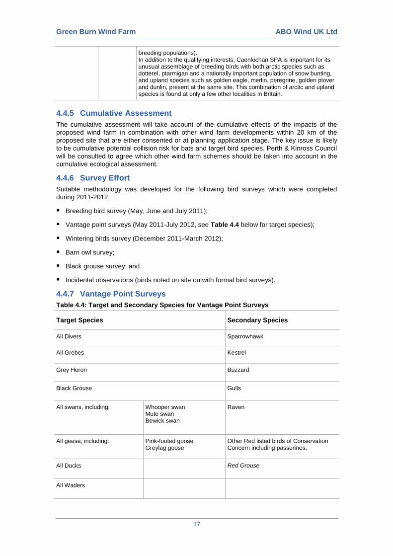
4.4.7 Vantage Point Surveys
Table 4.4: Target and Secondary Species for Vantage Point Surveys
Target Species Secondary Species
All Divers Sparrowhawk
All Grebes Kestrel
Grey Heron Buzzard
Black Grouse Gulls
All swans, including: Whooper swan Mute swan Bewick swan
Raven
All geese, including: Pink-footed goose Greylag goose
Other Red listed birds of Conservation Concern including passerines.
All Ducks Red Grouse
All Waders
Green Burn Wind Farm ABO Wind UK Ltd
18
All Annex I and Schedule 1 raptors, including:
Peregrine Falcon Golden Eagle Merlin Barn Owl Short-eared Owl Hen Harrier Marsh harrier
Two VPs were considered sufficient to provide coverage of the proposed turbine footprint area
plus a buffer of 200-500 m. A total of 123 hours per Vantage point have been watched as
detailed below in Table 4.5 and Table 4.6.
In response to a preliminary consultation, SNH has advised that “you appear to have done an
adequate amount of survey work for birds to inform decision makers in carrying out an
assessment of the proposed impact of a wind farm at this location on breeding and wintering
bird populations.”
SNH further commented that “The site does not overlap with any Special Protection Areas for
Birds (SPA) or Sites of Special Scientific Interest (SSSI) designated for birds”.
SNH gave the following comments on nearby designations for bird species:
“Forest of Clunie SPA/SSSI Key species – Hen Harrier, Osprey, Short-eared Owl and Merlin.
Drumfork – Kingseat lies beyond the core range for all species except Osprey, where it lies at
the edge of its core range.
Loch of Lintrathen SPA, RAMSAR and SSSI Both sites are important for wintering Greylag and
Pink-footed Geese. As far as geese are concerned, information we possess indicates that the
Drumfork - Kingseat site is not used as a feeding and roosting site by either species for the last
25 years. Overflying geese are likely to be flying well above the height of even the highest
terrestrial turbines currently being installed. We would therefore not require vantage point
watches specifically for geese.
Cairngorms Massif SPA Caenlochan Ben Vrackie These sites appear to beyond the connectivity
distance for Golden Eagle which is 9 km and the core range is 3 km. Therefore the Drumfork –
Kingseat site lies beyond this distance. Other species would not appear to be of concern.”
Table 4.5: Summary of Hours Watched per month per VP
Month No. Of Hours
May 2011 6
June 2011 6
July 2011 6
August 2011 6
September 2011 6
October 2011 6
November 2011 (incl. 1st December 2011)
* 24
December 2011 (excl. 1st December 2011)
* 6
January 2012 3
Green Burn Wind Farm ABO Wind UK Ltd
19
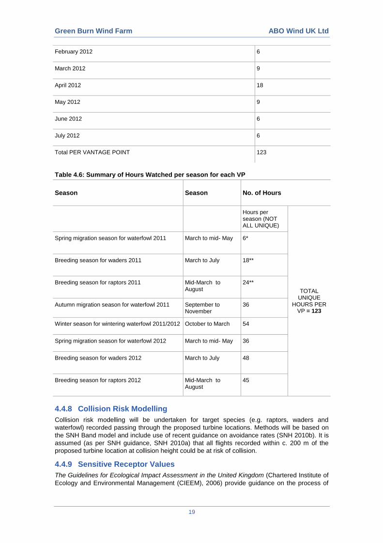
Table 4.6: Summary of Hours Watched per season for each VP
Season Season No. of Hours
Hours per season (NOT ALL UNIQUE)
TOTAL UNIQUE
HOURS PER VP = 123
Spring migration season for waterfowl 2011 March to mid- May 6*
Breeding season for waders 2011 March to July 18**
Breeding season for raptors 2011 Mid-March to August
24**
Autumn migration season for waterfowl 2011 September to November
36
Winter season for wintering waterfowl 2011/2012 October to March 54
Spring migration season for waterfowl 2012 March to mid- May 36
Breeding season for waders 2012 March to July 48
Breeding season for raptors 2012 Mid-March to August
45
4.4.8 Collision Risk Modelling
Collision risk modelling will be undertaken for target species (e.g. raptors, waders and
waterfowl) recorded passing through the proposed turbine locations. Methods will be based on
the SNH Band model and include use of recent guidance on avoidance rates (SNH 2010b). It is
assumed (as per SNH guidance, SNH 2010a) that all flights recorded within c. 200 m of the
proposed turbine location at collision height could be at risk of collision.
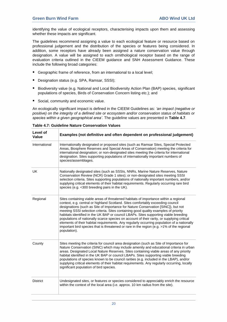
4.4.9 Sensitive Receptor Values
The Guidelines for Ecological Impact Assessment in the United Kingdom (Chartered Institute of
Ecology and Environmental Management (CIEEM), 2006) provide guidance on the process of
February 2012 6
March 2012 9
April 2012 18
May 2012 9
June 2012 6
July 2012 6
Total PER VANTAGE POINT 123
Green Burn Wind Farm ABO Wind UK Ltd
20
identifying the value of ecological receptors, characterising impacts upon them and assessing
whether these impacts are significant.
The guidelines recommend assigning a value to each ecological feature or resource based on
professional judgement and the distribution of the species or features being considered. In
addition, some receptors have already been assigned a nature conservation value through
designation. A value will be assigned to each ornithological receptor based on the range of
evaluation criteria outlined in the CIEEM guidance and SNH Assessment Guidance. These
include the following broad categories:
Geographic frame of reference, from an international to a local level;
Designation status (e.g. SPA, Ramsar, SSSI);
Biodiversity value (e.g. National and Local Biodiversity Action Plan (BAP) species, significant
populations of species, Birds of Conservation Concern listing etc.); and
Social, community and economic value.
An ecologically significant impact is defined in the CIEEM Guidelines as: ‘an impact (negative or
positive) on the integrity of a defined site or ecosystem and/or conservation status of habitats or
species within a given geographical area’. The guideline values are presented in Table 4.7.
Table 4.7: Guideline Nature Conservation Values
Level of Value
Examples (not definitive and often dependent on professional judgement)
International Internationally designated or proposed sites (such as Ramsar Sites, Special Protected Areas, Biosphere Reserves and Special Areas of Conservation) meeting the criteria for international designation; or non-designated sites meeting the criteria for international designation. Sites supporting populations of internationally important numbers of species/assemblages.
UK Nationally designated sites (such as SSSIs, NNRs, Marine Nature Reserves, Nature Conservation Review (NCR) Grade 1 sites); or non-designated sites meeting SSSI selection criteria. Sites supporting populations of nationally important numbers, and/or supplying critical elements of their habitat requirements. Regularly occurring rare bird species (e.g. <300 breeding pairs in the UK).
Regional Sites containing viable areas of threatened habitats of importance within a regional context, e.g. central or highland Scotland. Sites comfortably exceeding council designations (such as Site of Importance for Nature Conservation [SINC]), but not meeting SSSI selection criteria. Sites containing good quality examples of priority habitats identified in the UK BAP or council LBAPs. Sites supporting viable breeding populations of nationally scarce species on account of their rarity, or supplying critical elements of their habitat requirements. Any regularly occurring population of a nationally important bird species that is threatened or rare in the region (e.g. >1% of the regional population).
County Sites meeting the criteria for council area designation (such as Site of Importance for Nature Conservation (SINC) which may include amenity and educational criteria in urban areas. Designated Local Nature Reserves. Sites containing viable areas of any priority habitat identified in the UK BAP or council LBAPs. Sites supporting viable breeding populations of species known to be council rarities (e.g. included in the LBAP), and/or supplying critical elements of their habitat requirements. Any regularly occurring, locally significant population of bird species.
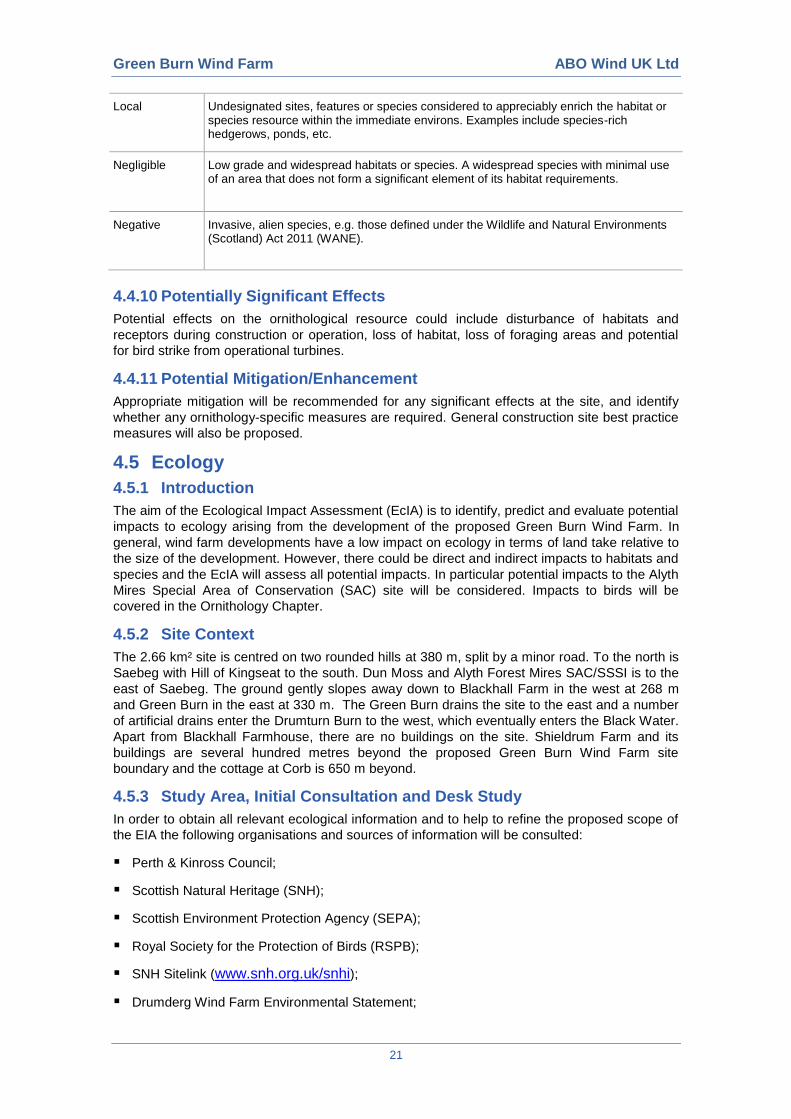
District Undesignated sites, or features or species considered to appreciably enrich the resource within the context of the local area (i.e. approx. 10 km radius from the site).
Green Burn Wind Farm ABO Wind UK Ltd
21
Local Undesignated sites, features or species considered to appreciably enrich the habitat or species resource within the immediate environs. Examples include species-rich hedgerows, ponds, etc.
Negligible Low grade and widespread habitats or species. A widespread species with minimal use of an area that does not form a significant element of its habitat requirements.
Negative Invasive, alien species, e.g. those defined under the Wildlife and Natural Environments (Scotland) Act 2011 (WANE).
4.4.10 Potentially Significant Effects
Potential effects on the ornithological resource could include disturbance of habitats and
receptors during construction or operation, loss of habitat, loss of foraging areas and potential
for bird strike from operational turbines.
4.4.11 Potential Mitigation/Enhancement
Appropriate mitigation will be recommended for any significant effects at the site, and identify
whether any ornithology-specific measures are required. General construction site best practice
measures will also be proposed.
4.5 Ecology
4.5.1 Introduction
The aim of the Ecological Impact Assessment (EcIA) is to identify, predict and evaluate potential
impacts to ecology arising from the development of the proposed Green Burn Wind Farm. In
general, wind farm developments have a low impact on ecology in terms of land take relative to
the size of the development. However, there could be direct and indirect impacts to habitats and
species and the EcIA will assess all potential impacts. In particular potential impacts to the Alyth
Mires Special Area of Conservation (SAC) site will be considered. Impacts to birds will be
covered in the Ornithology Chapter.
4.5.2 Site Context
The 2.66 km² site is centred on two rounded hills at 380 m, split by a minor road. To the north is
Saebeg with Hill of Kingseat to the south. Dun Moss and Alyth Forest Mires SAC/SSSI is to the
east of Saebeg. The ground gently slopes away down to Blackhall Farm in the west at 268 m
and Green Burn in the east at 330 m. The Green Burn drains the site to the east and a number
of artificial drains enter the Drumturn Burn to the west, which eventually enters the Black Water.
Apart from Blackhall Farmhouse, there are no buildings on the site. Shieldrum Farm and its
buildings are several hundred metres beyond the proposed Green Burn Wind Farm site
boundary and the cottage at Corb is 650 m beyond.
4.5.3 Study Area, Initial Consultation and Desk Study
In order to obtain all relevant ecological information and to help to refine the proposed scope of
the EIA the following organisations and sources of information will be consulted:
Perth & Kinross Council;
Scottish Natural Heritage (SNH);
Scottish Environment Protection Agency (SEPA);
Royal Society for the Protection of Birds (RSPB);
SNH Sitelink (www.snh.org.uk/snhi);
Drumderg Wind Farm Environmental Statement;
Green Burn Wind Farm ABO Wind UK Ltd
22
Welton of Creuchies Environmental Statement;
Land Owners/Tenants.
In response to a preliminary consultation, SNH has advised that the overlap of the site with Dun
Moss and Forest of Alyth Mires Special Area of Conservation (SAC) is a key issue, as “A wind
farm development which overlaps or is adjacent to the SAC will require an appraisal under the
EU Habitats Directive by either the Scottish Government or Perth and Kinross Council
depending on the size of the application. I think we would in all likelihood be advising that there
is likely to be a significant effect on the European designation”. Dun Moss is also designated as
a Site of Special Scientific Interest (SSSI).
Correspondence with SNH, along with other consultees, will continue where necessary, from
scoping throughout the duration of the EcIA in order to keep these key consultees informed.
An initial desk study for information regarding protected species and habitats has been
undertaken. The ecology desk study area comprised a search of designated sites and protected
species as detailed in Table 4.8. The following data sources were consulted:
SNH Sitelink (www.snh.org.uk/snhi);
SNH initial scoping response;
National Biodiversity Network (NBN) Gateway (www.searchnbn.net);
Land Owner;
Drumderg Wind Farm Environmental Statement; and
Welton of Creuchies Environmental Statement.
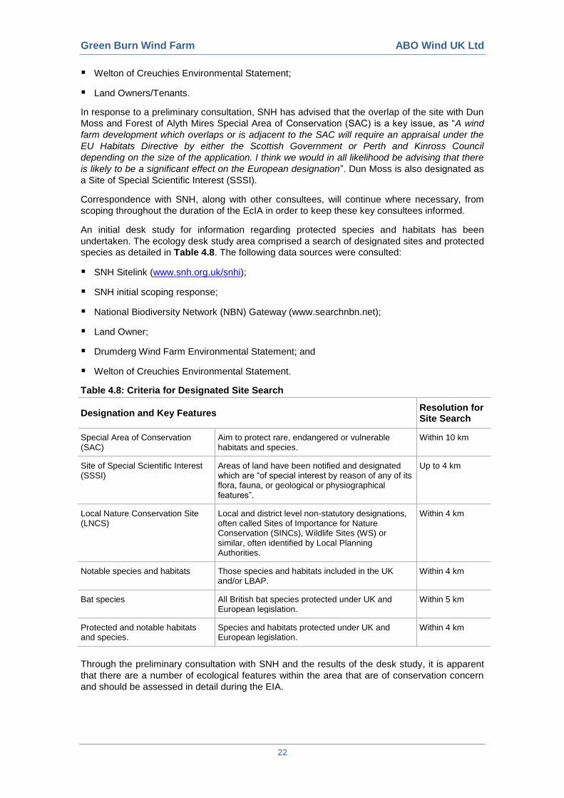
Table 4.8: Criteria for Designated Site Search
Designation and Key Features Resolution for Site Search
Special Area of Conservation (SAC)
Aim to protect rare, endangered or vulnerable habitats and species.
Within 10 km
Site of Special Scientific Interest (SSSI)
Areas of land have been notified and designated which are “of special interest by reason of any of its flora, fauna, or geological or physiographical features”.
Up to 4 km
Local Nature Conservation Site (LNCS)
Local and district level non-statutory designations, often called Sites of Importance for Nature Conservation (SINCs), Wildlife Sites (WS) or similar, often identified by Local Planning Authorities.
Within 4 km
Notable species and habitats Those species and habitats included in the UK and/or LBAP.
Within 4 km
Bat species All British bat species protected under UK and European legislation.
Within 5 km
Protected and notable habitats and species.
Species and habitats protected under UK and European legislation.
Within 4 km
Through the preliminary consultation with SNH and the results of the desk study, it is apparent
that there are a number of ecological features within the area that are of conservation concern
and should be assessed in detail during the EIA.
Green Burn Wind Farm ABO Wind UK Ltd
23
4.5.4 Sensitive Receptors
The EIA will recognise the following as potentially sensitive receptors:
Dun Moss and Forest of Alyth SAC and SSSI;
River Tay SAC;
Otter (European Protected Species);
All bats (European Protected Species); and
Groundwater Dependant Terrestrial Ecosystems.
4.5.5 Cumulative Assessment
The cumulative assessment will take account of the cumulative effects of the impacts of the
proposed wind farm in combination with other wind farm developments within 20 km of the
proposed site that are either consented or at planning application stage. The key potential issue
is likely to be cumulative potential collision risk for bats and target bird species. Perth & Kinross
Council will be consulted to agree which other wind farm schemes should be taken into account
in the cumulative ecological assessment.
4.5.6 Methodology
Fieldwork has already taken place on the site between 2011-2012.
4.5.7 Phase 1 Habitat and NVC Survey
The site and area surrounding it (to at least 40-100 m) was mapped to Phase 1 Habitat
standard. Survey of areas of particular botanical interest (habitats listed on Annex 1 of the
Habitats Directive i.e. areas of blanket bog, wet modified bog, marshy grassland and acid
grassland) were enhanced by the National Vegetation Classification (NVC) (Rodwell 1991a,
1991b, 1992, 1995) to map the communities present.
Guidance from Scottish Environmental Protection Agency (SEPA) states that a number of
habitats are reliant on the network of hydrological flow across the site and for any wind farm
development consideration must be given to these during the ecological assessment. Therefore
the NVC survey also encompassed the SEPA requirement to consider direct and indirect effects
on Groundwater Dependent Terrestrial Ecosystems (GWDTE).
Habitats were mapped onto a 1:10,000 Ordnance Survey base map using the standard Phase 1
classification and mapping codes. The minimum mappable unit was 40 m x 40 m. Use was
made of target notes, quadrat data and vegetation maps in order to provide descriptive
information, species lists and the location of rare or localised species and/or habitats. Mapped
habitats were subsequently digitised using a geographical information system (GIS).
4.5.8 Badger survey
A thorough search for badger evidence was undertaken within the site and surrounding area up
to a minimum of 50 m, where accessible. All evidence of badger was recorded including setts
(and their status), bedding, scratch marks, paths, prints, guard hairs, latrines, dung and signs of
foraging. The survey concentrated on habitats suitable for sett excavation including woodlands,
woodland margins and other drier parts of the site. Target notes were made of all identified
badger signs, confirmed or potential, including the location of activity, and a description, with a
10-figure grid reference taken from a hand held GPS.
4.5.9 Otter and Water Vole Survey
All watercourses and waterbodies within the site (and a 200 m buffer) within the site were
surveyed by an experienced ecologist for otter and water vole, searching for field signs in
accordance with best practice. The surveys were carried out in dry weather and not following
periods of heavy rain. The water bodies included the Drumturn Burn and Green Burn into Leapit
Burn. Areas of potentially suitable terrestrial habitat either side of the burns were also surveyed.
Green Burn Wind Farm ABO Wind UK Ltd
24
4.5.9.1 Otter
Surveys were carried out along all suitable watercourses for evidence of otter and all evidence
(i.e. spraints, sign heaps, rolling places, slides, footprints, holts, resting up sites) was recorded
using a hand held GPS and accompanying target notes. The location of activity, a description
of the type of activity and a 10-figure grid reference was recorded. Where any resting up sites
were recorded, their likely usage was assessed and recorded appropriately e.g. breeding,
temporary resting up.
4.5.9.2 Water Vole
Water vole surveys were carried out along all suitable watercourses (slow flowing and low
gradient) across the site. The surveys followed standard techniques to search for signs of water
vole including: footprints, run-ways in vegetation, burrows, droppings, lawns, nests, feeding
stations, and latrines. The location of all signs was recorded using a hand held GPS with
accompanying target notes.
4.5.10 Badger
A thorough search for badger evidence was undertaken within the site and surrounding area up
to a minimum of 50 m, where accessible. All evidence of badger was recorded including: setts
(and their status), bedding, scratch marks, paths, prints, guard hairs, latrines, dung and signs of
foraging. The survey concentrated on habitats suitable for sett excavation including woodlands,
woodland margins and other drier parts of the site. Target notes were made of all identified
badger signs, confirmed or potential, including the location of activity, and a description, with a
10-figure grid reference taken from a hand held GPS.
4.5.11 Red Squirrel Survey
An assessment was made of the site for its potential to support red squirrels. Walkover surveys
to search for evidence of squirrel feeding signs and dreys were carried out. This focused on
areas of woodland bounding the western part of the site and those patches of woodland to the
southwest boundary of the site. Trees were checked for the presence of squirrel dreys and field
signs were searched for in suitable areas of habitat (e.g. feeding remains). The location of signs
and sightings were recorded using a hand held GPS and accompanying target notes.
4.5.12 Bats
All bat species found in the UK are legally protected. Given the potential for foraging bats within
the site, bat surveys were undertaken. Bat surveys were conducted in accordance with the
principles and methods within Natural England’s Bats and onshore wind turbines (Interim
guidance) (2012) and the Bat Conservation Trust guidelines.
The site was assessed to be likely of low value to bats. An appropriate level of bat surveys were
undertaken for the development guided by an initial assessment of risk factors i.e. the bat
species present; the quality of the local bat habitat elements; and the scale, topography and
location.
Bat surveys were undertaken between May 2012 and October 2012 inclusive to cover the key
periods (June-July) when maternity roosts are most stable and during the dispersal periods
(August-September) when young bats disperse and adult bats move to swarming and mating
sites.
4.5.12.1 Day Survey
A walkover of the site was undertaken to identify potential roost sites, commuting routes and
foraging areas. A map based search was also undertaken for areas up to 500 m from the site
that could have key bat habitat features.
4.5.12.2 Bat Night Time Transect Survey
Manual transect surveys were carried out in May, August and September 2012. Two routes
were walked on each occasion with 10 timed point count stops for each. Bat passes were also
recorded en route between points. The order of the point count stops was altered (and the
Green Burn Wind Farm ABO Wind UK Ltd
25
direction of the route changed) per visit, to account for variations in bat activity throughout the
night. Noted information included species of bat, activity, flight height and direction of travel.
Survey started after sunset and was undertaken using broadband Anabat detectors. Recordings
were made onto a memory card or handheld PDA and later analysed to confirm species
identification where necessary.
4.5.12.3 Remote Monitoring
Ten Anabat locations were surveyed in May, July and September 2012 and three were
surveyed in October 2012. Locations were chosen to take into account the habitat features on
the site as well as providing good overall coverage of the draft proposed turbine locations.
Further survey effort was designed based on the results obtained. In September three new
locations and seven previous ones were surveyed and in October three locations were
surveyed. Detectors were placed in a secure Pelicase and locked to trees, telegraph poles or
fence posts and discretely left on the ground, angled to point upwards to hub height. A weather
station was put on site for the duration of the surveys and results were analysed against this
data to assess weather effects.
4.5.13 Fish
A day walkover habitat assessment has been undertaken by an experienced Fisheries
Consultant (Dr Bob Morgan, Morgan Fisheries Consultancy).
4.5.14 Other Species
Note was made of any other species of note (e.g. UK BAP species and reptiles), or habitat
suitability for these species. Any ponds and ditches were assessed for their suitability for
amphibians. No detailed night-time survey was undertaken for these species.
4.5.15 Sensitive Receptors Values
The Guidelines for Ecological Impact Assessment in the United Kingdom (Chartered Institute of
Ecology and Environmental Management (CIEEM), 2006) provide guidance on the process of
identifying the value of ecological receptors, characterising impacts upon them and assessing
whether these impacts are significant.
The guidelines recommend assigning a value to each ecological feature or resource based on
professional judgement and the distribution of the species or features being considered. In
addition, some receptors have already been assigned a nature conservation value through
designation. The value is determined within a defined geographical context based on the
framework outlined in Table 4.9.
An ecologically significant impact is defined in the CIEEM Guidelines as: ‘an impact (negative or
positive) on the integrity of a defined site or ecosystem and/or conservation status of habitats or
species within a given geographical area’.
Table 4.9: Guideline Nature Conservation Values
Level of Value Examples (not definitive and often dependent on professional judgement)
International Internationally designated or proposed sites (such as Ramsar Sites, Special Protected Areas, Biosphere Reserves and Special Areas of Conservation) meeting the criteria for international designation; or non-designated sites meeting the criteria for international designation. Sites supporting populations of internationally important numbers of species/assemblages.
UK Nationally designated sites (such as SSSIs, NNRs, Marine Nature Reserves, Nature Conservation Review (NCR) Grade 1 sites); or non-designated sites meeting SSSI selection criteria. Sites supporting populations of nationally important numbers, and/or supplying critical elements of their habitat requirements. Regularly occurring rare bird species (e.g. <300 breeding pairs in the UK).
Green Burn Wind Farm ABO Wind UK Ltd
26
Regional Sites containing viable areas of threatened habitats of importance within a regional context, e.g. central or highland Scotland. Sites comfortably exceeding council designations (such as Site of Importance for Nature Conservation [SINC]), but not meeting SSSI selection criteria. Sites containing good quality examples of priority habitats identified in the UK BAP or council LBAPs. Sites supporting viable breeding populations of nationally scarce species on account of their rarity, or supplying critical elements of their habitat requirements. Any regularly occurring population of a nationally important bird species that is threatened or rare in the region (e.g. >1% of the regional population).
County Sites meeting the criteria for council area designation (such as Site of Importance for Nature Conservation (SINC) which may include amenity and educational criteria in urban areas. Designated Local Nature Reserves. Sites containing viable areas of any priority habitat identified in the UK BAP or council LBAPs. Sites supporting viable breeding populations of species known to be council rarities (e.g. included in the LBAP), and/or supplying critical elements of their habitat requirements. Any regularly occurring, locally significant population of bird species.
District Undesignated sites, or features or species considered to appreciably enrich the resource within the context of the local area (i.e. approx. 10 km radius from the site).
Local Undesignated sites, features or species considered to appreciably enrich the habitat or species resource within the immediate environs. Examples include species-rich hedgerows, ponds, etc.
Negligible Low grade and widespread habitats or species. A widespread species with minimal use of an area that does not form a significant element of its habitat requirements.
Negative Invasive, alien species, e.g. those defined within the Wildlife and Natural Environments (Scotland) Act 2011.
4.5.16 Potentially Significant Effects
Potential effects on the ecology of the area could arise from the development at the
construction, operational and decommissioning stages.
Effects during the construction could include:
Presence of people;
Vegetation, top soil and sub-soil removal resulting in habitat loss and habitat fragmentation;
Development of watercourse crossings;
Noise;
Vehicular traffic;
Ground and excavation works;
Construction of turbine foundations and access routes;
Creation of temporary construction compounds and storage areas;
Removal of site offices/compounds and final site clear away after construction; and
Routing of services and utilities.
During the operational phase, effects could include:
Vehicular traffic;
Presence of people;
Green Burn Wind Farm ABO Wind UK Ltd
27
Noise;
Vibration;
Drainage; and
Wind turbine activity.
During de-commissioning effects are predicted to be similar to those during construction.
4.5.17 Potential Mitigation/Enhancement
Mitigation measures specific to the potential impacts identified above will be recommended as
part of the EcIA and could include:
Pre-construction checks for notable and protected species such as otter, badger, water vole
and red squirrel;
Ecological clerk of works to be retained to monitor and manage ecological issues during the
development;
Buffer zones to restrict impacts upon sensitive habitats.
4.5.18 References
Chanin, P. (2003) Monitoring the Otter Lutra lutra. Conserving Natura 2000 Rivers.
Monitoring series No. 10. English Nature, Peterborough.
Chartered Institute of Ecology and Environmental Management (2006) Guidelines for Ecological
Impact Assessment in the United Kingdom (version 7 July 2006).
http://www.ieem.org.uk/ecia/index.html
Hundt, L. et al (2012) Bat Surveys: Good Practice Guidelines. BCT, London.
Natural England (2009) bats and onshore wind turbines: Interim guidance. Nastural England,
Technical Information Note 051.
Rodwell, J.S. (1991a). British Plant Communities Vol 1. Woodlands & Scrub. Cambridge
University Press, Cambridge.
Rodwell, J.S. (1991b). British Plant Communities Vol 2. Mires and Heaths. Cambridge
University Press, Cambridge.
Rodwell, J.S. (1992). British Plant Communities Vol 3. Grasslands and Montane Communities.
Cambridge University Press, Cambridge.
Rodwell, J.S. (1995). British Plant Communities Vol 4. Aquatic Communities, Swamps and Tall-
Herb Fens. Cambridge University Press, Cambridge.
Strachan, R. (1998) The Water Vole Conservation Handbook. Wildlife Research Unit,
Department for Zoology, University of Oxford.
Scottish Natural Heritage (2010) Survey Methods for Use in Assessing the Impacts of Onshore
Windfarms on Bird Communities produced by SNH in November 2005 and updated in 2010.
Green Burn Wind Farm ABO Wind UK Ltd
28
4.6 Noise
4.6.1 Site Context
Noise issues related to wind farm developments most frequently arise in connection with the
operation of the development. Construction related noise issues are less sensitive and arise
infrequently. The main focus of this method statement is therefore operational noise. In relation
to Green Burn Wind Farm, the following points are noted:
Up to ten residential properties are located within approximately 2 km of the site boundary,
with the closest properties at Blackhall Farm and Shieldrum Farm located approximately 300
m and 450 m from the site boundary respectively. Background noise measurements are
therefore likely to be required;
Drumderg Wind Farm lies immediately to the east of the site. There are no receptors located
between the sites, however there is potential for cumulative effects on the closest receptors
to each site from both developments under certain wind directions. Cumulative effects will
require to be considered; and
Drumderg Wind Farm is operational, therefore existing background noise levels at nearby
receptors may include operational noise from the Drumderg turbines. Current guidance on
establishing background noise levels for wind farm noise studies advises that noise levels
should be recorded only in the absence of noise from other wind farms, therefore the
operation of Drumderg will limit the approach to obtaining background noise levels. The
agreed approach to establishing noise limits will be a key issue to be addressed during EIA
scoping, and in particular through consultation with the Environmental Health Dept of Perth &
Kinross Council.
Concerns related to amplitude modulation and low frequency noise may arise. There is
comprehensive published information and advice which will be referred to in addressing these
issues.
4.6.2 Scope of Work and Method
Our assessment will follow statutory guidance and best practice in assessing the noise effects
of the wind energy developments; our specific approach will be as follows:
The assessment of operational turbine noise will be undertaken in accordance with The
Assessment and Rating of Noise from Wind Farms (ETSU-R-97), Planning Advice Note
1/2011 Planning and Noise and Institute of Acoustics’ (IoA) A Good Practice Guide to the
Application of ETSU-R-97 for the Assessment and Rating of Wind Turbine Noise (May
2013). The assessment will also refer to Government advice and the findings of the Salford
University report into aerodynamic modulation of wind turbine noise. We will take account of
all of these in agreeing our scope and method of work with Perth & Kinross Council;
Predictions of noise immissions at the nearest receptors will be undertaken in accordance
with ISO 9613-2 Acoustics – Attenuation of sound during propagation outdoors - Part 2:
General method of calculation (1996), using manufacturer data for the candidate model of
turbine. The predictions will indicate the receptors at which noise levels over 35 dBLA90 are
predicted, and thus the requirement for background noise measurements. The predictions
will also consider cumulative noise effects with Drumderg Wind Farm and any other turbines
agreed with Perth & Kinross Council;
It is proposed that background noise measurements be undertaken at 4 locations:
Corb (316425, 756835);
Shieldrum Farm (314809, 755800);
Kingseat (314749, 754527); and
Smyrna (318640, 753222).
Green Burn Wind Farm ABO Wind UK Ltd
29
Background noise monitoring will be undertaken over a period of 14-21 days (depending
on weather conditions) to ensure data capture during representative conditions. Measured
data will be correlated with wind speed data measured simultaneously on the site and
regression analysis undertaken to determine typical background noise levels at each wind
speed. In accordance with ETSU-R-97, noise limits for Quiet Daytime and Night-time
periods will be derived from the measurement data for each receptor;
Following design freeze, noise predictions will be undertaken for the final layout and
candidate turbine, and predicted noise levels evaluated against derived noise limits. Noise
predictions will take account of directivity effects and attenuation due terrain or topographic
effects, where appropriate;
An assessment of cumulative noise will take account of the existing operational Drumderg
Wind Farm, two wind farms – Bamff and Tullymurdoch – for which applications are
scheduled to be examined at Public Inquiry, and Saddle Hill for which a request for a
Scoping Opinion has been received by Perth & Kinross Council; and
Construction noise effects will be considered in accordance with BS5228-1:2009 Code of
practice for noise and vibration control on construction and open sites, and traffic noise in
accordance with Design Manual for Roads and Bridges (DMRB) guidance.
4.7 Cultural Heritage
4.7.1 Site Context, Study Area, Sensitive Receptors & Cumulative Assessment
The land within the proposed development area boundary is devoid of statutorily protected sites,
though there is a concentration of recorded, non-statutory sites, for the most part comprising
clusters of evidence which indicate past farming activity – remains of hut circles and/or
platforms, enclosures, field systems and field clearance cairns. Although these types of remains
can signify activity in widely differing periods, there is further evidence to suggest that at least
some (and perhaps the greater number) of these remains are of prehistoric date. One indicator
is the remains of a monument close to the centre of the proposed development site (HER no.
MPK4024), which has been identified as a kerb cairn (that is, a funerary monument) of Neolithic
/Bronze Age origin. Other factors, such as the morphology of some of the remains and their
position on higher ground (relative to later farming activity) also point to a prehistoric
provenance being more likely, though the dates of these sites have not been proved through the
recovery of datable material from excavation and ascribing dates to them must consequently
remain conjectural. There is still a very real possibility that at least some of the remains visible
are of rather later (most probably post-medieval) date, not least since other physical remains of
activity of that date, and of broadly similar physical character, also appear to be present at a
variety of locations in the general vicinity.
Potential also exists for further, associated material to exist within the proposed development
area which has not yet been identified or recognised. Any such hitherto unrecorded evidence is
as likely, if not more likely, to comprise further upstanding (if relatively slight) remains, as
opposed to buried remains, and any such survivals will most likely constitute additional detail
related to existing recorded sites, rather than completely new and discrete discoveries. There
are several reasons for this.
One is the fact that this area was the subject of a very deliberate, targeted and detailed survey
by the RCAHMS in the 1980s (the results of which were published in 1990). The area has thus
been very closely scrutinized, in modern times, by professional field archaeologists. This alone
is certainly a contributory factor in explaining the relatively high density of recorded material
compared to other areas of similar landscape character elsewhere in Scotland. A second
reason relates to the character of the land, especially in areas where bedrock appears to be
close to the surface. The relative (stress, relative) lack of arable agricultural activity in the area,
especially in the modern era, will mean there has been less opportunity for attrition of the
remains of formerly upstanding sites and features than would be witnessed in areas where
modern arable agricultural activity has been intensive. That said, there appears to be a strong
Green Burn Wind Farm ABO Wind UK Ltd
30
indication (in the form of the morphological characteristics of many of the identified sites) of
settlement in the area in the Bronze/Iron Age (broadly speaking during the last two millennia
BC), which would lead to the conclusion that there is potential for buried remains of that date to
survive in certain locations - where, for example, peat cover has subsequently formed.
Inspection of the recorded evidence in the area immediately around (within ca 1 km) of the
proposed development site boundary reveals a very similar range of evidence with one or two
additions. Further clusters of settlement and associated agricultural remains (whether of
prehistoric or post-medieval date) have been identified to north, east, and north west. In some
cases, clearly more modern farming remains (post-Medieval and early modern) lie in the same
general areas, with a higher concentration to the west on the lower lying west facing slopes
leading down to the river. These include a fermtoun (MPK 4121) and what appears to be a
rather grander tower/country house (MPK 4124) to the south-east. To the NNE, the supposed
medieval “castle” at Corb (HER no MPK 3982) seems rather more likely to represent the
remains of a former hunting lodge, though a building is depicted at Corb on Timothy Pont’s early
seventeenth century map, which attests to the physical presence at this location at that date and
suggests that a Medieval origin for building on this site is entirely feasible.
In terms of statutorily protected sites, a smattering of SAMs and listed buildings lie in the more
immediate surrounding area to the proposed development site (within 1-2 km) but examples are
not especially numerous and a number of the more closely located examples appear to lie
within forestry plantations. The nearest SAM (HS no. 4703 = HER no MPK3983) lies roughly 1
km north of the northern edge of the proposed development area and has been identified as a
further example of a prehistoric farming settlement. This, though, is the only such nationally
significant statutorily protected site within 1.5 km of the proposed development site boundaries.
Further statutorily protected sites lie at rather greater distances from the proposed development
site boundaries; within 5 km of the proposed development site boundary, these are noticeably
more populous in a 180 degree northern arc around the proposed development area, compared
to the equivalent southern arc. These will all require to be assessed in terms of their relationship
to the proposed development site and those archaeological/cultural heritage sites which lie in
and around it and in the wider landscape.
There will also be a need for assessment of the potential for cumulative indirect effects on
cultural heritage sites, most obviously in relation to the wind farm at Drumderg. Reference to
CANMORE and to the archaeological reports produced during and after the EIA for the
Drumderg WF indicate that it too sits in a well recorded, landscape with surviving remains of
both prehistoric and post-Medieval periods especially prominent.
Overall, the distribution, character and relative proximity of some statutorily protected sites to
the proposed development site boundary, especially SAMs, suggests that the statutory
consultees are likely to seek further information as part of the EIA on the potential for indirect
impacts of the proposed development, perhaps especially in terms of the potential for
cumulative indirect impacts involving Drumderg WF.
4.7.2 Consultations
As part of the EIA, consultations with the statutory consultees will be undertaken: with Historic
Scotland for cultural heritage sites of national significance; and with the Perth & Kinross
Heritage Trust, in their capacity as archaeological advisers to Perth & Kinross Council.
4.7.3 Baseline Data Collection
4.7.3.1 Overview
Baseline studies for the area proposed for development comprise a desk-based assessment
and a field survey (in the form of a walk-over survey). A desk-based assessment is also carried
out for the immediate surrounding landscape (the area within 1 km of the proposed
development boundary). Subsequent further assessment may be undertaken further afield if
demanded in scoping responses. Study of the wider landscape is undertaken to establish the
local archaeological and historical context, in order to provide a broader understanding of the
Green Burn Wind Farm ABO Wind UK Ltd
31
historical development of the area proposed for development and the potential for as-yet-
unidentified archaeological remains within that area.
4.7.3.2 Desk-based Assessment
Desk-based assessment of the area proposed for development and its immediate surrounding
landscape comprises:
Creation of a Geographic Information System (GIS). Inclusion of baseline data in the project
GIS (as detailed below) allows the accurate plotting of the location and extent of known
cultural heritage features in relation to current Ordnance Survey base maps;
Current data on Scheduled Ancient Monuments (SAMs) and Listed Buildings is obtained
from PASTMAP (a map-enabled query system for Scottish National and Regional
Archaeological and Architectural Datasets, maintained by the Royal Commission on the
Ancient and Historical Monuments of Scotland;
Information on Historic Gardens and Designed Landscapes (HGDLs) is searched on the
Inventory available on the HS website;
Information on Conservation Areas is searched on the relevant Local Authority Local Plans;
The National Monuments Record of Scotland (NMRS) is consulted through PASTMAP;
The local Sites and Monuments Record, maintained by Perth & Kinross Heritage Trust, is
consulted remotely;
Relevant aerial photographs are viewed at the RCAHMS in Edinburgh in order to identify any
hitherto unknown sites or features of archaeological interest.
Ordnance Survey (OS) maps of the proposed development area and Pre-Ordnance Survey
maps of the area of interest, held by the National Library of Scotland (NLS), are identified
and examined. These maps are accessible online through the NLS website. Relevant maps
generally range in date from the sixteenth to the early twentieth century;
Relevant published primary sources are consulted to expand the level of information
available from on-line descriptions of archive material;
Readily accessible primary and secondary historical sources on the area are consulted for
information on its history and past land use.
4.7.3.3 Field Survey
A walkover survey of the area proposed for development is undertaken, involving a two person
team walking in systematic transects across the proposed development area, checking known
sites and seeking to identify and record and hitherto unknown sites. The locations of any
features visited or identified have their positions recorded by GPS and any such features are
also recorded by means of written description and, where appropriate, supplemented by
measured sketches and photographs.
4.7.4 Sensitive Receptor Values
4.7.4.1 Setting
Baseline – Identification of cultural heritage features are to be assessed (i.e. establishment of
which features lie within the visual envelope provided by the project landscape architect).
4.7.4.2 Sensitivity of the feature
Sensitivity to effects on setting (the degree to which change can be accommodated without
detrimental effects on the relationship between the feature and its setting) will be determined
with reference to:
The cultural heritage importance of the receptor (as defined by its statutory/non-statutory
designation or established by professional judgement);
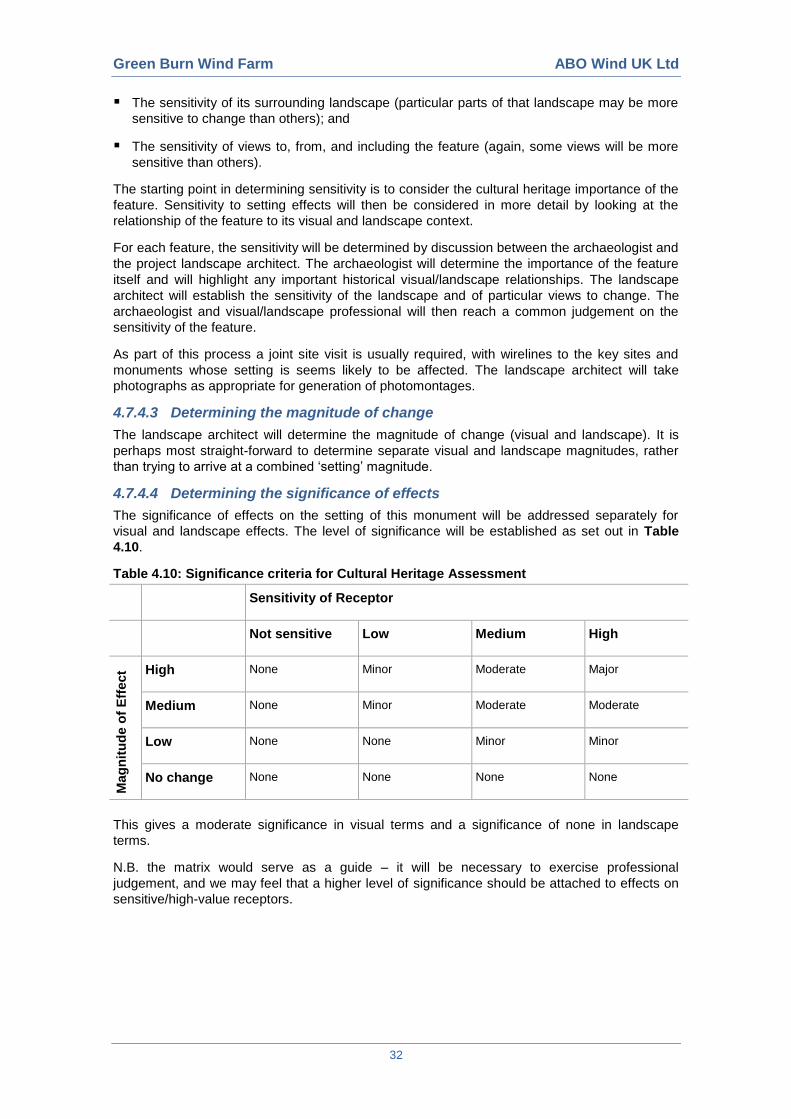
Green Burn Wind Farm ABO Wind UK Ltd
32
The sensitivity of its surrounding landscape (particular parts of that landscape may be more
sensitive to change than others); and
The sensitivity of views to, from, and including the feature (again, some views will be more
sensitive than others).
The starting point in determining sensitivity is to consider the cultural heritage importance of the
feature. Sensitivity to setting effects will then be considered in more detail by looking at the
relationship of the feature to its visual and landscape context.
For each feature, the sensitivity will be determined by discussion between the archaeologist and
the project landscape architect. The archaeologist will determine the importance of the feature
itself and will highlight any important historical visual/landscape relationships. The landscape
architect will establish the sensitivity of the landscape and of particular views to change. The
archaeologist and visual/landscape professional will then reach a common judgement on the
sensitivity of the feature.
As part of this process a joint site visit is usually required, with wirelines to the key sites and
monuments whose setting is seems likely to be affected. The landscape architect will take
photographs as appropriate for generation of photomontages.
4.7.4.3 Determining the magnitude of change
The landscape architect will determine the magnitude of change (visual and landscape). It is
perhaps most straight-forward to determine separate visual and landscape magnitudes, rather
than trying to arrive at a combined ‘setting’ magnitude.
4.7.4.4 Determining the significance of effects
The significance of effects on the setting of this monument will be addressed separately for
visual and landscape effects. The level of significance will be established as set out in Table
4.10.
Table 4.10: Significance criteria for Cultural Heritage Assessment
Sensitivity of Receptor
Not sensitive Low Medium High
Mag
nit
ud
e o
f E
ffect
High None Minor Moderate Major
Medium None Minor Moderate Moderate
Low None None Minor Minor
No change None None None None
This gives a moderate significance in visual terms and a significance of none in landscape
terms.
N.B. the matrix would serve as a guide – it will be necessary to exercise professional
judgement, and we may feel that a higher level of significance should be attached to effects on
sensitive/high-value receptors.
Green Burn Wind Farm ABO Wind UK Ltd
33
4.8 Aviation and Telecommunications
4.8.1 Aviation Impact Assessment
4.8.1.1 Identification of key receptors
The aviation baseline assessment will identify all air traffic control and air defence radars within
the study area, all airports and airfields within 30 km and all aeronautical radio navigation aids
and radio transmitter sites within 10 km of the wind turbine site. In addition, the location of
relevant military low flying system features relative to the wind turbine site will be established.
On the basis of an initial review of the site, no significant aviation issues are expected but this
would require confirmation in relation to:
Radar line of sight from the NERL Lowther Hill primary surveillance radar; and
Radar line of sight from the RAF Leuchars primary surveillance radar.
4.8.1.2 Assessment
Radar line of sight assessment will be conducted using GlobalMapper software and NASA
ASTER digital terrain data to establish whether the NERL Lowther Hill and RAF Leuchars
radars are capable of detecting turbines at the site. The expectation is that there will be no line
of sight from either radar.
The conclusions from the radar line of sight assessment will be validated through consultation
with NERL and the MoD. However NERL will not provide a pre-planning response without
payment and MoD are currently unable to respond to pre-planning consultations.
4.8.2 Telecommunications Impact Assessment
It is understood that Ofcom has already been consulted. Initial review indicates that there may
be microwave and scanning telemetry links from the Corb transmitter mast with the potential for
these to be affected.
The potential for television interference will be assessed by querying the BBC reception tool and
by map analysis of potentially affected domestic properties.
4.8.3 Cumulative Impact Assessment
Assessment of cumulative effects on telecommunications and aviation of the Green Burn Wind
Farm with other existing and proposed wind farms will be conducted using the methods outlined
above, with reference to written material on other projects as appropriate.
4.9 Geology, Hydrology and Hydrogeology
4.9.1 Site Context
British Geological Survey online mapping (www.bgs.ac.uk/data/mapViewers) shows that the
majority of the site is underlain by Glacial Till. Two areas of peat coverage are shown in the east
of the site (east of Hill of Kingseat and Saebeg). Alluvium deposits associated with the
tributaries of the Drumturn Burn are present in the northwest of the application area. Bedrock is
exposed at or near surface towards the south of the site around Hill of Kingseat.
The solid geology underlying the superficial deposits across the region comprises the
metamorphic rocks of the Cairn Gibbs Psammite Formation of the Southern Highland Group.
This unit comprises schistose psammite and gritty psammite with minor units of phyllitic to
schistose pelite.
The bedrock of the Southern Highland Group is classified by the Scottish Environment
Protection Agency (SEPA) as a low productivity aquifer comprising small amounts of
groundwater in near surface weathered zones and fractures. Little groundwater will be present
in the Glacial Till, which characteristically has a low bulk permeability. Near to watercourses it is
likely that the alluvium contains groundwater which is in local hydraulic continuity with the
streams.
Green Burn Wind Farm ABO Wind UK Ltd
34
The application site is shown by SEPA’s interactive mapping application
(www.gis.sepa.org.uk/rbmp) as regionally being within the Strathardle bedrock and local sand
and gravel aquifers Drinking Water Protected Zone. Groundwater status within the bedrock has
been classified with an overall status of Good with High confidence in 2008.
The site falls within the catchment of the River Tay, a Freshwater Fish (Salmonid) Protected
Water which is also a Special Area of Conservation (SAC). The Black Water (to the west) and
the River Ericht (to the south) are part of the River Tay SAC. A number of small watercourses,
which form tributaries to the River Tay, rise within the application area and nearby, although it is
noted that these do not part of the River Tay SAC.
The Drumturn Burn is located to the east of the application boundary and has been classified by
SEPA in 2008 as being a watercourse with Good status with Medium confidence. A number of
tributaries to the Drumturn Burn flow within the site boundary and have their source within the
site boundary. These tributaries flow westwards into the Drumturn Burn. The Drumturn Burn
flows into the Black Water, which also has been classified by SEPA as having a Good status.
The Green Burn, an unclassified watercourse, is located along part of the eastern boundary of
the application site, flowing southwards into the Leapit Burn which in turn flows into the Burn of
Drimmie, which forms a tributary to the River Ericht.
The SEPA floodplain map (www.sepa.org.uk/flooding/flood_extent_maps) indicates that the site
is in an area at risk of flooding associated with the Drumturn Burn on the western site boundary.
The extent of flooding partially encroaches onto the application area. In addition flooding
associated with the Black Water is present to the west of the application site.
4.9.2 Consultations
As part of the consultation phase of the project we would seek to obtain environmental data and
views of the proposed development from SEPA, Scottish Natural Heritage, Scottish Water, the
Tay Salmon District Salmon Fisheries Board and Perth and Kinross Council.
4.9.3 Study Area
The study area will include the site, and water dependent features and habitats that are in linked
with the site, and which are located within 1 km of the site boundary.
4.9.4 Sensitive Receptors
Based on the initial review of the site setting, key issues and risks that may need to be
considered by the geology, hydrogeology and hydrology assessment include:
Water Quality and Fisheries. It is evident that the watercourses at and near to site are of a
high quality and are tributaries of the high value salmon fisheries administered by the Tay
District Salmon Fisheries Board (TDSFB). It will be necessary to engage with the TDSFB to
discuss the scheme proposals;
Peat and Peat Slide Risk. Peat is recorded by BGS mapping to be present in part of the
site. The thickness and distribution of the peat should be confirmed as part of the baseline
assessment and with this information the need for a peat slide risk can be determined; and
Groundwater Dependent Terrestrial Ecosystems (GWDTE). There is potential that
GWDTE may be present on site. National Vegetation Classification (NVC) surveys will be
completed in order to identify areas of potential GWDTE; these data, combined with a review
of the site hydrogeology can be used to inform the site design and constraints mapping, and
if required further investigation can be identified to prove (or otherwise) the contribution
groundwater makes to sustaining these habitats.
Review of the site location shows there are few properties within or near to the site and thus it is
considered that the presence of private water supplies is unlikely to pose a significant
development constraint. Similarly, there are few watercourses shown within the site and the
presence of watercourses or the crossings of watercourses is unlikely to form a development
constraint.
Green Burn Wind Farm ABO Wind UK Ltd
35
4.9.5 Cumulative Assessment
With the incorporation of industry standard mitigation measures and use of sustainable drainage
techniques (SuDS) it is not anticipated that development of Green Burn Wind Farm would result
in any cumulative impact on the geological or water environment. This would be confirmed in
the impact assessment.
4.9.6 Survey Methods
4.9.6.1 Initial Baseline (Desk Based) Assessment and Constraints Mapping
It is anticipated that the following sources of information would be reviewed as part of the
baseline assessment:
The Drumderg Wind Farm ES
The Scoping Opinion
Collation of published geological, hydrological and hydrogeological information, including
hydrometric data for the area
Use of topographical maps and aerial photography to identify catchments, water bodies,
springs and boreholes
Collation of published historic hydrological and flooding information for the immediate area
Collation of data on public and private water abstractions (supplied by SEPA and Perth and
Kinross Council)
Using the information collated as part of the baseline assessment, constraints with respect to
wind turbine development would be identified using GIS. These might include areas considered
unsuitable for development due to peat thickness, standoff to sensitive water features, buffers to
private water supplies and preferred locations for watercourse crossings.
4.9.6.2 Baseline Assessment
A site visit and walkover survey (including water features and watercourse crossing surveys and
a private water supply survey) would be undertaken, in order to:
Verify the information collected during the desk and baseline study;
Gain further appreciation of the site, including a good overall understanding of its
hydrological regime;
Undertake a visual assessment of the main surface waters and identify private water
supplies;
Identify drainage patterns, areas vulnerable to erosion or sediment deposition, and any
pollution risks;
Visit any identified GWDTE (in consultation with the project ecologists);
Prepare a schedule of potential watercourse crossings; and
Undertake peat depth probing (if required).
4.9.6.3 Impact Assessment
As part of the impact assessment, review of potential GWDTEs and private water supplies
within 250 m of proposed turbines and borrow pits and 100 m of proposed access tracks and
cabling routes would be undertaken in accordance with SEPA wind farm planning guidance.
Potential impacts on the geological and water environment would be identified, and mitigation
measures required to address these impacts would be proposed. The impact assessment would
make reference where appropriate to published guidance from CIRIA, SEPA, SR and REUK.
Green Burn Wind Farm ABO Wind UK Ltd
36
Given the location of the site, it is considered that a basic Flood Risk Assessment (FRA) would
need to be prepared to satisfy Scottish Planning Policy. This would be incorporated into the text
of the impact assessment, and is likely to include recommendations for the control and
management of runoff from parts of the proposed built development. It is considered that it will
not be necessary to undertake any hydraulic modelling of any proposed watercourse crossings.
4.9.7 Sensitive Receptor Values
A qualitative risk assessment methodology will be used to assess the magnitude of the potential
effects. Two factors will be considered using this approach: the sensitivity of the receiving
environment and the potential magnitude, should that potential impact occur.
This approach provides a mechanism for identifying the areas where mitigation measures are
required, and for identifying mitigation measures appropriate to the risk presented by the
scheme. This approach also allows effort to be focused on reducing risk where the greatest
benefit may result.
Criteria for determining the significance of effects are provided in Table 4.11, Table 4.12 and
Table 4.13, below. Effects of ‘major’ and ‘moderate’ significance are considered to be
‘significant’ in terms of the EIA Regulations.
The significance of the potential effects will be defined by taking into account two main factors;
the sensitivity of the receiving environment and the potential magnitude should that effect occur.
The sensitivity of the receiving environment (i.e. the baseline quality of the receiving
environment as well as its ability to absorb the impact without perceptible change) is defined in
Table 4.11.
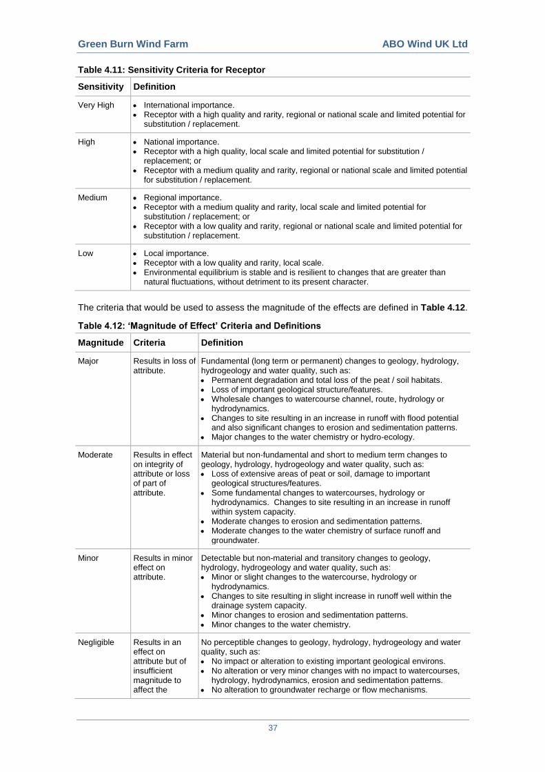
Green Burn Wind Farm ABO Wind UK Ltd
37
Table 4.11: Sensitivity Criteria for Receptor
Sensitivity Definition
Very High International importance. Receptor with a high quality and rarity, regional or national scale and limited potential for
substitution / replacement.
High National importance. Receptor with a high quality, local scale and limited potential for substitution /
replacement; or Receptor with a medium quality and rarity, regional or national scale and limited potential
for substitution / replacement.
Medium Regional importance. Receptor with a medium quality and rarity, local scale and limited potential for
substitution / replacement; or Receptor with a low quality and rarity, regional or national scale and limited potential for
substitution / replacement.
Low Local importance. Receptor with a low quality and rarity, local scale. Environmental equilibrium is stable and is resilient to changes that are greater than
natural fluctuations, without detriment to its present character.
The criteria that would be used to assess the magnitude of the effects are defined in Table 4.12.
Table 4.12: ‘Magnitude of Effect’ Criteria and Definitions
Magnitude Criteria Definition
Major Results in loss of attribute.
Fundamental (long term or permanent) changes to geology, hydrology, hydrogeology and water quality, such as: Permanent degradation and total loss of the peat / soil habitats. Loss of important geological structure/features. Wholesale changes to watercourse channel, route, hydrology or
hydrodynamics. Changes to site resulting in an increase in runoff with flood potential
and also significant changes to erosion and sedimentation patterns. Major changes to the water chemistry or hydro-ecology.
Moderate Results in effect on integrity of attribute or loss of part of attribute.
Material but non-fundamental and short to medium term changes to geology, hydrology, hydrogeology and water quality, such as: Loss of extensive areas of peat or soil, damage to important
geological structures/features. Some fundamental changes to watercourses, hydrology or
hydrodynamics. Changes to site resulting in an increase in runoff within system capacity.
Moderate changes to erosion and sedimentation patterns. Moderate changes to the water chemistry of surface runoff and
groundwater.
Minor Results in minor effect on attribute.
Detectable but non-material and transitory changes to geology, hydrology, hydrogeology and water quality, such as: Minor or slight changes to the watercourse, hydrology or
hydrodynamics. Changes to site resulting in slight increase in runoff well within the
drainage system capacity. Minor changes to erosion and sedimentation patterns. Minor changes to the water chemistry.
Negligible Results in an effect on attribute but of insufficient magnitude to affect the
No perceptible changes to geology, hydrology, hydrogeology and water quality, such as: No impact or alteration to existing important geological environs. No alteration or very minor changes with no impact to watercourses,
hydrology, hydrodynamics, erosion and sedimentation patterns. No alteration to groundwater recharge or flow mechanisms.
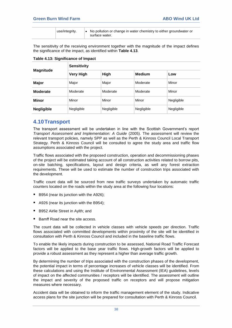
Green Burn Wind Farm ABO Wind UK Ltd
38
use/integrity. No pollution or change in water chemistry to either groundwater or surface water.
The sensitivity of the receiving environment together with the magnitude of the impact defines
the significance of the impact, as identified within Table 4.13.
Table 4.13: Significance of Impact
Magnitude Sensitivity
Very High High Medium Low
Major Major Major Moderate Minor
Moderate Moderate Moderate Moderate Minor
Minor Minor Minor Minor Negligible
Negligible Negligible Negligible Negligible Negligible
4.10 Transport
The transport assessment will be undertaken in line with the Scottish Government’s report
Transport Assessment and Implementation: A Guide (2005). The assessment will review the
relevant transport policies, namely SPP as well as the Perth & Kinross Council Local Transport
Strategy. Perth & Kinross Council will be consulted to agree the study area and traffic flow
assumptions associated with the project.
Traffic flows associated with the proposed construction, operation and decommissioning phases
of the project will be estimated taking account of all construction activities related to borrow pits,
on-site batching, specifications, layout and design criteria, as well any forest extraction
requirements. These will be used to estimate the number of construction trips associated with
the development.
Traffic count data will be sourced from new traffic surveys undertaken by automatic traffic
counters located on the roads within the study area at the following four locations:
B954 (near its junction with the A926);
A926 (near its junction with the B954);
B952 Airlie Street in Aylth; and
Bamff Road near the site access.
The count data will be collected in vehicle classes with vehicle speeds per direction. Traffic
flows associated with committed developments within proximity of the site will be identified in
consultation with Perth & Kinross Council and included in the baseline traffic flows.
To enable the likely impacts during construction to be assessed, National Road Traffic Forecast
factors will be applied to the base year traffic flows. High-growth factors will be applied to
provide a robust assessment as they represent a higher than average traffic growth.
By determining the number of trips associated with the construction phases of the development,
the potential impact in terms of percentage increases of vehicle classes will be identified. From
these calculations and using the Institute of Environmental Assessment (IEA) guidelines, levels
of impact on the affected communities / receptors will be identified. The assessment will outline
the impact and severity of the proposed traffic on receptors and will propose mitigation
measures where necessary.
Accident data will be obtained to inform the traffic management element of the study. Indicative
access plans for the site junction will be prepared for consultation with Perth & Kinross Council.
Green Burn Wind Farm ABO Wind UK Ltd
39
Committed developments (as defined by the IHT standards) will be included where traffic
generation information can be advised by Perth & Kinross Council. In the absence of individual
data, a ‘High’ national road traffic forecast will be assumed to have accounted for any committed
schemes.
4.11 Air & Climate
4.11.1 Site Context
The assessment of impacts on air quality and climate change will consider the construction and
operational phases of the development. The operation of the wind farm will generate no direct
atmospheric emissions, however emissions will be generated during the construction phase of
the development.
The wind farm will offset emissions of gases from fossil fuel power stations which are believed
to contribute to climate change, however, emissions will be generated during the lifecycle of the
turbine, during the construction phase and potentially through the removal or modification of
carbon sinks (e.g. peat bogs or forest). In relation to Green Burn Wind Farm, the following
points are noted:
At least ten residential properties are located within approximately 2 km the site boundary,
with the closest properties approximately 300 m from the boundary. Potential exists for
adverse effects on air quality due to dust during construction activities; and
Desktop review of site hydrology/hydrogeology indicates potential for peat on site, thus
consideration of carbon emissions associated with modification to this carbon sink will
require to be considered. A small parcel of forestry is located within the site boundary,
therefore potential effects on carbon sequestration due to loss of forestry (if felled) will also
be considered.
4.11.2 Scope of Work and Method
Our method of assessment will be as follows:
The assessment of impacts on local air quality will consider emissions of combustion gases
generated from transport and plant associated with the construction of the wind farm, and
the potential for nuisance impacts on local receptors from fugitive dust emissions associated
with the construction phase of the development. The assessment will consider impacts to
receptors within 2 km from site infrastructure;
The assessment of air quality impacts will be desk-based, with baseline air quality levels
determined with reference to published data sources. The assessment of impacts on local air
quality will be undertaken as a screening assessment in line with Local Air Quality
Management Technical Guidance LAQM. TG(09) (2009);
The assessment of potential dust nuisance will be qualitative and will consider the likelihood
of adverse effects based on the likelihood of dust emissions, distance and orientation of
receptors to the site and prevailing meteorological conditions. The assessment will be desk
based and will utilise criteria set out in TG(09) guidance and Planning Advice Note PAN 50
Annex B: The Control of Dust at Surface Mineral Workings; and
A calculation of carbon payback will be undertaken in accordance with the method outlined
in the report Calculating Carbon Savings from Wind Farms on Scottish Peatlands - A New
Approach (2008) and subsequent amendments. The assessment will calculate an overall
carbon payback period for the wind farm based on:
Carbon emission savings (based on emissions from different power sources);
Loss of carbon due to production, transportation, erection, operation and dismantling of
the wind farm;
Loss of carbon from backup power generation;

Green Burn Wind Farm ABO Wind UK Ltd
40
Loss of carbon-fixing potential of peat land;
Loss and/or saving of carbon stored in peat land (by peat removal or changes in
drainage);
Loss and/or saving of carbon associated with tree felling;
Carbon saving due to improvement of habitat; and
Loss and/or saving of carbon-fixing potential as a result of forestry clearance.
The calculations will be undertaken using SEPA’s carbon calculator spreadsheet, with
suitable parameters applied to reflect site specific conditions where appropriate. Where
uncertainty exists over specific site conditions, up to 3 alternative scenarios will be
considered and the results of each presented to demonstrate the sensitivity of the payback
period to specific conditions on-site. The report will include details of all assumptions.
Green Burn Wind Farm ABO Wind UK Ltd
41
5 CONSULTATION
5.1 Scoping Consultations
An extensive consultation programme is planned for the Green Burn Wind Farm development,
involving both statutory and non-statutory stakeholders as well as members of the public.
To assist with EIA scoping, ABO Wind has already undertaken preliminary consultations with
Perth and Kinross Council and SNH. The programme of formal consultation begins with the
submission of this Scoping Report to Perth and Kinross Council.
The Statutory Consultees include Perth and Kinross Council, Scottish Environment Protection
Agency, Scottish Natural Heritage, Scottish Water, Civil Aviation Authority, Transport Scotland
and Historic Scotland. Relevant non-statutory consultees will also be consulted throughout the
EIA process, many of which are identified in the various technical topic areas in Section 4 of this
Scoping Report.
5.2 Responses to Scoping
Consultees are invited to comment on environmental issues raised by the proposed
development, the scope of the EIA to be undertaken, the methods to be adopted in undertaking
the EIA, the content and structure of the ES, as presented in this Scoping Report. Consultees
are also invited to highlight any additional issues that they consider should be addressed within
the EIA and to identify any sources of information which may e of relevance to the EIA team.
All consultee responses would be directed, in writing to:
Lucy Forte
Project Manager
ABO Wind UK Ltd
Alba Innovation Centre
Alba Campus
Livingston
EH54 7GA
All responses will be considered and, where appropriate, the scope of the EIA will be amended
accordingly. The ES will present the outcomes of the scoping consultation process and explain
how comments were addressed in the EIA process and reported in the ES.
5.3 Public Consultation
Additional to the scoping consultation, a public consultation exercise will be undertaken during
the EIA and planning pre-application process. The public consultation will seek to inform the
local community of the proposals and to provide them with the opportunity to provide their views
on the proposed development. The outcomes of the public consultations, and how comments
were addressed in the EIA process, will be reported in the ES.

Green Burn Wind Farm ABO Wind UK Ltd
42
Page Intentionally Left Blank
Green Burn Wind Farm ABO Wind UK Ltd
FIGURES


![GGEXT131 Galloper Wind Farm Scoping Study Final[1]](https://img.pdfslide.net/doc/110x75/620660528c2f7b173007278a/ggext131-galloper-wind-farm-scoping-study-final1.jpg)