Embed Size (px)
Citation preview
1
I N F O R M A T I O N N O T E
Greenspace Establishmenton Brownfield Land:the Site Selection andInvestigation Process
D E C E M B E R 2 0 0 7
FCIN091
B Y K I E R O N D O I C K A N D T O N Y H U T C H I N G S O F F O R E S T R E S E A R C H
INTRODUCTION
Background
This Information Note describes a method for the selectionand investigation of brownfield sites for re-developmentinto community greenspace. The term ‘brownfield’ describes‘previously developed land’, which is defined as land whichis or was occupied by a permanent structure (excludingagricultural or forestry buildings) and associated fixedsurface infrastructure (Department for Communities andLocal Government, 2006). The establishment of greenspaceon brownfield land can provide many social andenvironmental benefits, such as opportunities to walk andcycle, increased wildlife and flora, and reduction in noiseand air pollution. It can also contribute to the economicregeneration of an area. Greenspace establishment embodiesthe government’s drive towards sustainable development(Office of the Deputy Prime Minister, 2003; 2004).
The national forest strategies for Scotland, England andWales (Forestry Commission Scotland, 2006; Departmentfor Environment, Food and Rural Affairs, 2007; ForestryCommission Wales, 2001) contain commitments to theregeneration of brownfield land into communitywoodland and greenspace. Consequently, the ForestryCommission is committed to the establishment of newwoodland and to delivering a comprehensive package of
231 Corstorphine RoadEdinburghEH12 7AT
www.forestry.gov.uk
SUMMARY
This Information Note describes investigation of brownfield land for potential redevelopment into greenspace. Written forsite owners, foresters, planners, managers and consultants, it gives step-by-step guidance on site selection and evaluation.Brownfield sites are exemplified by site variability, soil infertility and hazards. An important objective of site evaluation isto identify and quantify potential risks and liabilities, such as contamination, that may be present on site. The presence of asignificant pollutant linkage categorises a site as contaminated. The process of identifying and managing pollutant linkagesis described. Importantly, the categorisation of contaminated land will not apply to all sites considered for greenspaceestablishment; examples of the opportunities to progress efficiently through site evaluation to greenspace establishment aregiven. It is important that key decisions are correct, accountable and substantiated. Attention should be given to the overallsustainability of the site including inclusive accessible use, sustainable establishment of vegetation, environmental protectionand enhancement. The foundations of a quality greenspace establishment project are effective site selection and preparation;success will be manifested through site sustainability and local community involvement.
urban, economic and social regeneration throughgreenspace establishment, for example through theCommunity Forest Partnership. A ‘soft’ end-use,greenspace can require less stringent remediationobjectives than the building of residential properties(stringency increases in the order: industrial < open space< domestic). Furthermore, trees and plants have beenshown to demonstrate huge potential in the reclamationand remediation of brownfield land (Hutchings, 2002).
Legislation
Like other industrialised countries, the UK has a legacy ofurban and peri-urban brownfield sites, many of which arepotentially contaminated (Environment Agency, 2004)(see Defining Contaminated Land on page 4). Currentplanning guidelines specify that the redevelopment of landin England, Scotland and Wales must ensure ‘suitabilityfor use’. In other words, all risks at a site must be assessedand evaluated according to the intended use of the land.Concurrently, Part IIA of the Environmental ProtectionAct 1990 (Department for Environment, Food and RuralAffairs, 2006) (subsequently referred to herein as Part IIA)requires all local authorities to inspect their area forcontaminated land and to secure its remediation to acondition that is suitable for current types of use basedupon ‘fitness for purpose’ principles. Part IIA wasimplemented in April 2000 in England, July 2000 in
2
Scotland and July 2001 in Wales. Importantly, not all sitesconsidered for re-development as greenspace will bedefined as contaminated land. However, under currentlegislation an assessment is required to identify all of therisks present at a site and those that may arise followingmodification, alteration or management, for example ascommunity greenspace.
Other legislation that should also be considered in re-development of brownfield land includes statutorynuisance, food safety, health and safety, waste and landfilllegislation; and planning and development control (via theDepartment for Communities and Local Government).Water legislation (including the Water Resources Act1991 and the Groundwater Regulations 1998) and thePollution Prevention and Control Act 1999 should also beconsidered in consultation with the Environment Agency(Department for Environment, Food and Rural Affairs,2006).
Objectives of this Information Note
The objectives of this Information Note are to highlight tosite owners, foresters, planners, managers and consultants:
• the processes of site selection and investigation;
• the importance of the site selection process, siteassessment, site evaluation and stakeholderinvolvement to successful greenspace establishment;
• statutory obligations concerning protection of theenvironment, human health, property, water coursesand cultural and natural heritage;
• site properties and characteristics conducive to thesustainable establishment of vegetation andgreenspace habitats (including soil, water and hazardassessments);
• what to expect and what to do next, step-by-step.
OVERVIEW OF GREENSPACEDEVELOPMENT
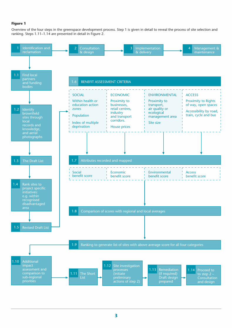
A greenspace development project can be considered as afour-step process (Figure 1): Step 1: Identification andreclamation, Step 2: Consultation and design, Step 3:Implementation and delivery, Step 4: Management andmaintenance. This Information Note is principally
concerned with the actions undertaken in Step 1 - siteidentification and reclamation. Actions undertaken inSteps 2–4 are discussed in brief to highlight that success ateach step is highly dependent upon the effectiveness ofpreceding steps. An overview of each step is given belowto outline the greenspace development process and to setthe scene for this Information Note.
Step 1 can be divided into: site identification andshortlisting according to local availability, project goalsand regional priorities; evaluation of shortlisted sitesaccording to soil conditions, likely impacts of vegetationestablishment, liabilities and risks, and remediation ofunacceptable risks. Alternatively, the site may be droppedfrom the shortlist. Step 2 can be divided into consultationof statutory and non-statutory stakeholders and design ofthe master plan for implementation. Step 3 is theimplementation step where the reclaimed site isregenerated into a greenspace. Delivery comprises civilengineering of infrastructure (and possibly buildings),provision of facilities and services (e.g. lighting), groundpreparation, planting and fencing. Step 4 comprisesmanagement, monitoring and maintenance and the on-going processes of health and safety assessments, habitatcare, community liaison and pest control.
SITE IDENTIF ICATION ANDSHORTLISTING
There are many potentially suitable sites in the UK for re-development as greenspace and it is recommended that ashortlist is made of the sites with the highest potential toprovide an optimal range of social, environmental andeconomic benefits. The Newlands Initiative(www.forestry.gov.uk/newlands), a joint North WestDevelopment Agency and Forestry Commission project,has developed procedures for identifying and shortlistingsites which have become a model to use for other sites.The procedures are: preliminary site identification; sitescoring and ranking according to their advantages andconstraints. The scoring uses the ‘Public Benefit RecordingSystem’ (PBRS) (Public Benefit Recording System, 2006),which considers four topic areas – social, economic,environment and access (Figure 1). A variety of indicatorsare assessed for each topic, points assigned and the fourtotals, whilst retaining equal weighting, are used tocompare and rank sites based on the benefits that the sitewould provide, and from that, a shortlist of the mostsuitable sites can be drawn up.
3
Consultation& design
Implementation & delivery
Management &maintenance
Identification andreclamation
Find localpartnersand fundingbodies
Rank sites toproject specific initiatives:e.g. within recogniseddisadvantagedarea
Additional impact assessment and comparison tosub-regionalpriorities
The Short List
Site investigationprocesses(initiatepreliminaryactions of step 2)
Remediation(if required)Draft designprepared
Proceed toto step 2 –Consultation and design
BENEFIT ASSESSMENT CRITERIA
Identifybrownfieldsites throughlocalrecords and knowledge,and aerialphotographs
The Draft List
Revised Draft List
Within health oreducation action zones
Proximity tobusinesses,retail centres,industryand transportcorridors.
Comparison of scores with regional and local averages
Proximity totransport,air quality orecological management area
Proximity to Rightsof way, open spaces
Socialbenefit score
Ranking to generate list of sites with above average score for all four categories
Economicbenefit score
Environmentalbenefit score
Accessbenefit score
House prices
1.3
1.5
1.10
1.4
1.2
1.1
1 2 3 4
1.6
1.7 Attributes recorded and mapped
1.8
1.9
1.12
1.111.13 1.14
ECONOMICSOCIAL ACCESSENVIRONMENTAL
Accessibility by road, train, cycle and bus
Site sizeIndex of multiple deprivation
Population
Figure 1
Overview of the four steps in the greenspace development process. Step 1 is given in detail to reveal the process of site selection andranking. Steps 1.11–1.14 are presented in detail in Figure 2.
4
EVALUATION OFSHORTLISTED SITES
Code of practice
The Forestry Commission asserts that the establishment ofwoodland and associated greenspace should be in linewith environmental good practice, that natural andcultural heritage and important features of the landscapeare protected, and that UK Government policy andobjectives are observed. Therefore, shortlisted sites areevaluated in detail using desk-top studies and site surveysaccording to British Standards Codes of Practice (e.g. BSI,1999 and 2001), and guidelines from governmentdepartments and bodies (e.g. Forest Research, 2005a-d;Environment Agency 2000 and 2004; Department forEnvironment, Food and Rural Affairs, 2006; Office of theDeputy Prime Minister, 2004 and 2005).
Evaluation of soil condition and theimpacts of vegetation establishment
The abundance of soil, its fertility and potential to sustainvegetation, and the consequences of tree and plantgrowth, such as potential damage to pollution controlmeasures or cultural heritage, all contribute to the overallsuccess and sustainability of a greenspace project.Brownfield land is typified by site variability, siteinstability, poor drainage, potential contamination, soilinfertility and underground hazards (Moffat and McNeill,1994). Consequently, the soil environment is a focal pointof site investigations and it is important to continuallyaddress four questions throughout the site investigationprocess:
• Will the site support trees/vegetation? (Particularconsideration should be given to the water holdingcapacity, contamination, fertility and nutrient status,physical soil characteristics, soil cover and rootabledepth, and topography of the site).
• Will the establishment of the greenspace generate,amplify or negate risks and hazards?
• Will vegetation establishment adversely affect the site?
• How will the site be managed in the short and longterm?
A checklist of information to be collected is given on page20.
EEvvaalluuaattiioonn ooff RRiisskk aanndd LLiiaabbiilliittiieess
A vital component of evaluation is the assessment of risksand liabilities for each shortlisted site, incorporating thefollowing objectives:
• Identify the potential risks and liabilities that may bepresent on a site, including the potential forcontaminated land.
• Comprehensive review of potential end-uses for thesite.
• Assess the potential for, and likelihood of, success ofthe site for greenspace development.
• Protect developers and future users.
• Protect health of the environment.
• Ensure reclamation does not increase current risks orcreate new risks.
Details on the definition, identification and managementof contaminated land are given below.
DEFINING CONTAMINATEDLAND
As a consequence of industrial usage, brownfield siteshave the potential for residual contamination. Some of thebrownfield sites shortlisted may not be contaminated.However, a full evaluation is a must as it helps to identifywhich shortlisted sites will proceed to Step 2: Consultationand design. Contaminated land is defined as any land whichappears to be in such a condition, by reason of substanceson, in or under the land, that: a) significant harm is beingcaused or there is a significant possibility of such harmbeing caused; or b) pollution of controlled waters is being,or is likely to be caused. (Department for Environment,Food and Rural Affairs, 2006; s78A(2) of Part IIA of theEnvironmental Protection Act 1990).
A definition alone does not identify contaminated land; itdoes not detail the assessment criteria or inform on whatto do. Dealing with contaminated land is about riskmanagement, it is a process of identifying, assessing andjudging risks; taking actions to mitigate or anticipatethem; monitoring, and reviewing progress (EnvironmentAgency, 2004). The definition of ‘risk’ is the combinationof the probability (or frequency) of occurrence of a
5
defined hazard and the magnitude (including the seriousness)of the consequences of the occurrence. Where: a ‘hazard’is an event or situation (including a contamination source)which has the potential to cause ‘harm’ to targets ofconcerns (i.e. receptors). Harm may refer to, for example,disease, death or reduced yield (Environment Agency,2004). Harm is described in greater detail below.
Simply, a hazard can be a cracked paving slab. Therefore,the risk is the probability (or likelihood) that someone willtrip on the cracked slab and fracture a bone. Similarly, ahazard may be a container of organic solvent wastedumped in a field. The risk is the probability that thecontainer will leak and detrimentally affect life in thevicinity. Risk can be expressed numerically or literally.For example, one in every 10000 people are likely to fallon the broken slab and break a bone (i.e. a 1 in 10000chance); or, there is a very low risk of a person falling onthe broken slab and breaking a bone.
In the context of land contamination, there are three essentialelements that must be present to constitute viable risk:
A source – a substance (contaminant) that is in, on orunder the land and has the potential to cause harm, or tocause pollution of controlled waters, and may be point,linear, localised or diffuse.
A pathway – a route or means by which a receptor can beexposed to, or affected by, a contaminant. A pathwaymay be via groundwater, surface water or sediment, viadrains, air/dust or vapour, via direct contact (ingestion ordermal), via plant uptake or via the food chain.
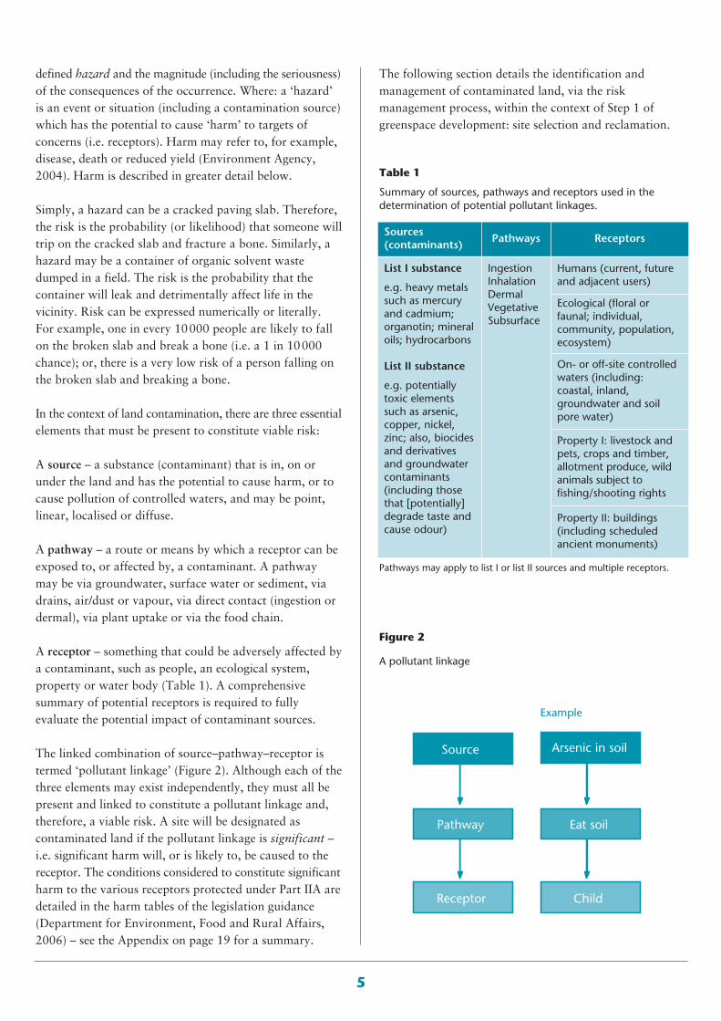
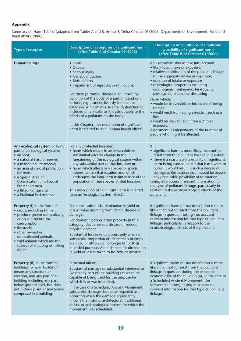
A receptor – something that could be adversely affected bya contaminant, such as people, an ecological system,property or water body (Table 1). A comprehensivesummary of potential receptors is required to fullyevaluate the potential impact of contaminant sources.
The linked combination of source–pathway–receptor istermed ‘pollutant linkage’ (Figure 2). Although each of thethree elements may exist independently, they must all bepresent and linked to constitute a pollutant linkage and,therefore, a viable risk. A site will be designated ascontaminated land if the pollutant linkage is significant –i.e. significant harm will, or is likely to, be caused to thereceptor. The conditions considered to constitute significantharm to the various receptors protected under Part IIA aredetailed in the harm tables of the legislation guidance(Department for Environment, Food and Rural Affairs,2006) – see the Appendix on page 19 for a summary.
Table 1
Summary of sources, pathways and receptors used in thedetermination of potential pollutant linkages.
Sources(contaminants)
Pathways Receptors
List I substance
e.g. heavy metalssuch as mercuryand cadmium;organotin; mineraloils; hydrocarbons
List II substance
e.g. potentiallytoxic elementssuch as arsenic,copper, nickel,zinc; also, biocidesand derivativesand groundwatercontaminants(including thosethat [potentially]degrade taste andcause odour)
IngestionInhalationDermalVegetativeSubsurface
Humans (current, futureand adjacent users)
Ecological (floral orfaunal; individual,community, population,ecosystem)
On- or off-site controlledwaters (including:coastal, inland,groundwater and soilpore water)
Property I: livestock andpets, crops and timber,allotment produce, wildanimals subject tofishing/shooting rights
Property II: buildings(including scheduledancient monuments)
Figure 2
A pollutant linkage
Source
Example
Pathway
Receptor
Arsenic in soil
Eat soil
Child
Pathways may apply to list I or list II sources and multiple receptors.
The following section details the identification andmanagement of contaminated land, via the riskmanagement process, within the context of Step 1 ofgreenspace development: site selection and reclamation.
6
RISK MANAGEMENT:IDENTIF ICATION ANDMANAGEMENT OFCONTAMINATED LAND
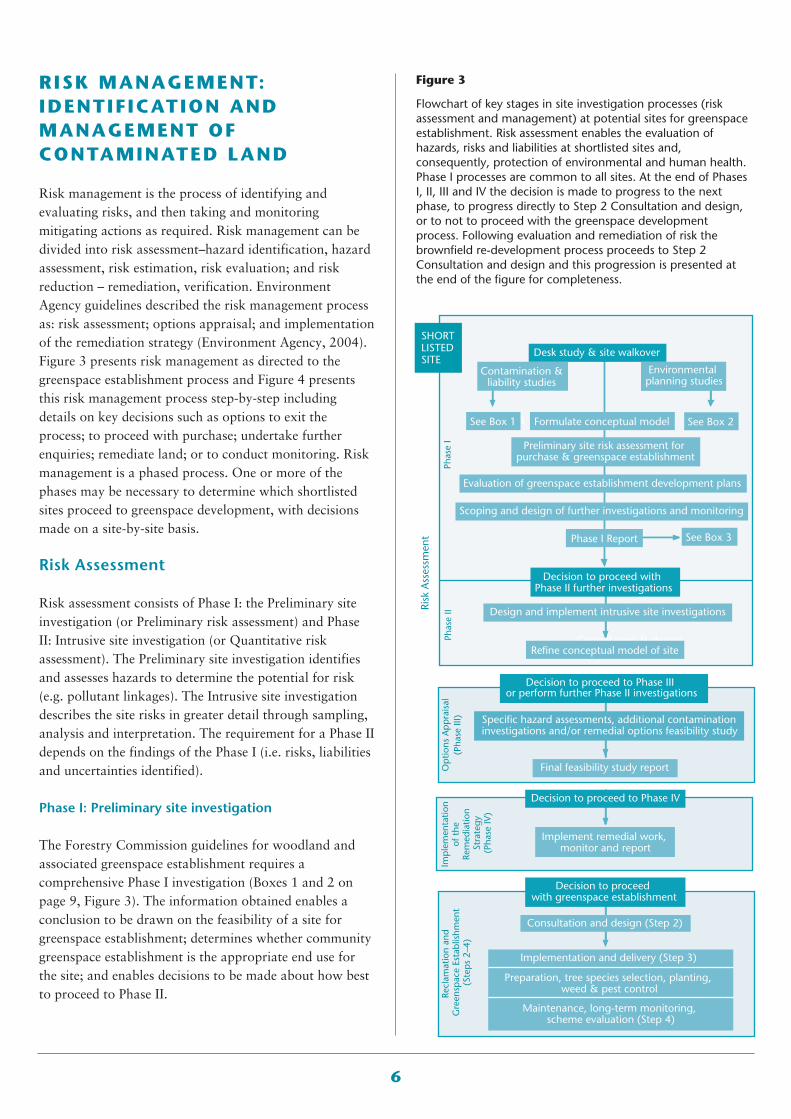
Risk management is the process of identifying andevaluating risks, and then taking and monitoringmitigating actions as required. Risk management can bedivided into risk assessment–hazard identification, hazardassessment, risk estimation, risk evaluation; and riskreduction – remediation, verification. EnvironmentAgency guidelines described the risk management processas: risk assessment; options appraisal; and implementationof the remediation strategy (Environment Agency, 2004).Figure 3 presents risk management as directed to thegreenspace establishment process and Figure 4 presentsthis risk management process step-by-step includingdetails on key decisions such as options to exit theprocess; to proceed with purchase; undertake furtherenquiries; remediate land; or to conduct monitoring. Riskmanagement is a phased process. One or more of thephases may be necessary to determine which shortlistedsites proceed to greenspace development, with decisionsmade on a site-by-site basis.
Risk Assessment
Risk assessment consists of Phase I: the Preliminary siteinvestigation (or Preliminary risk assessment) and PhaseII: Intrusive site investigation (or Quantitative riskassessment). The Preliminary site investigation identifiesand assesses hazards to determine the potential for risk(e.g. pollutant linkages). The Intrusive site investigationdescribes the site risks in greater detail through sampling,analysis and interpretation. The requirement for a Phase IIdepends on the findings of the Phase I (i.e. risks, liabilitiesand uncertainties identified).
Phase I: Preliminary site investigation
The Forestry Commission guidelines for woodland andassociated greenspace establishment requires acomprehensive Phase I investigation (Boxes 1 and 2 onpage 9, Figure 3). The information obtained enables aconclusion to be drawn on the feasibility of a site forgreenspace establishment; determines whether communitygreenspace establishment is the appropriate end use forthe site; and enables decisions to be made about how bestto proceed to Phase II.
Figure 3
Flowchart of key stages in site investigation processes (riskassessment and management) at potential sites for greenspaceestablishment. Risk assessment enables the evaluation ofhazards, risks and liabilities at shortlisted sites and,consequently, protection of environmental and human health.Phase I processes are common to all sites. At the end of PhasesI, II, III and IV the decision is made to progress to the nextphase, to progress directly to Step 2 Consultation and design,or to not to proceed with the greenspace developmentprocess. Following evaluation and remediation of risk thebrownfield re-development process proceeds to Step 2Consultation and design and this progression is presented atthe end of the figure for completeness.
Consultation & design
Risk
Ass
essm
ent
Phas
e I
Phas
e II
Op
tions
Ap
pra
isal
(Pha
se II
I)Re
clam
atio
n an
d G
reen
spac
e Es
tabl
ishm
ent
(Ste
ps
2–4)
Imp
lem
enta
tion
of t
he
Rem
edia
tion
Stra
tegy
(Pha
se IV
)
Desk study & site walkover
Decision to proceed with Phase II further investigations
Decision to proceed with greenspace establishment
Decision to proceed to Phase III or perform further Phase II investigations
Contamination &liability studies
See Box ASee Box 1 Formulate conceptual model
Phase I Report
See Box 2
See Box 3
Environmental planning studies
Preliminary site risk assessment for purchase & greenspace establishment
Evaluation of greenspace establishment development plans
Scoping and design of further investigations and monitoring
Design and implement intrusive site investigations
Specific hazard assessments, additional contamination investigations and/or remedial options feasibility study
Refine conceptual model of site
Final feasibility study report
Consultation and design (Step 2)
Implementation and delivery (Step 3)
Preparation, tree species selection, planting, weed & pest control
Maintenance, long-term monitoring, scheme evaluation (Step 4)
Implement remedial work, monitor and report
SHORT LISTED SITE
Decision to proceed to Phase IV
7
Phase Step-by-step Outputs obtained
Risk assessment
Phase I: Preliminary investigation
Phase Ia
Hazard identification
• Define context and state primary objectives • Desk study• Construct site plan and establish user history and contaminantsources (archive search)
• Collate previous site data• Consult with authorities and regulators for planning consents,statutory consents
• Environmental health, services and building control report,planning consents
• Anecdotal and local business information• Detail site topography; geology; hydrogeology; hydrology; geotechnicalstability; climatic, atmospheric and general environmental conditions
Site walk-over• Scoping ecological survey• Scoping heritage/archaeology survey• Screening soil survey (type, quantity, suitability for use)• Soil-forming materials survey• Characterise physical hazards
• Detailed summary of site history• Primary zonation of site according to the likelihoodof presence of contamination
• Contamination and liability study• Environmental planning study• Conceptual model of site• Identification of need for in depthecological/heritage surveys
• Lists of:- Possible contaminants- Potential exposure routes- Potential pollutant linkages- Risks to site users and neighbours- Environmental assets to be preserved/ promoted- Assumptions- Limitations- Uncertainties- Site constraints (physical hazards, drainagelimitations, subsurface buildings/structures,longterm maintenance issues, liabilities)- Biodiversity to be preserved/ promoted- Potentially useful tree species to be established on site
• Phase I Preliminary Investigation report (decisionrecord) on above, including conclusions onfeasibility of greenspace establishment and whatshould be done next.Ph
ase Ib Hazard
assessment
Construct conceptual modelPreliminary risk assessmentEvaluation of potential for greenspace establishment, potential usersurveyScope Phase II investigationsDecision record (outlined in Box 3, page 11)Potential to exit process
Figure 4
Summary step-by-step guide to the assessment and management of land contamination.
Phase Step-by-step Outputs obtained
Risk assessment
Phase II Intrusive site investigation
Phase IIa
Risk estimationHazard quantification • Define context and state objectives
• Design sampling strategy for intrusive investigation, plus analytical strategy
• Detail methods of site investigation to be employed and justifications• Detail targeted and non-targeted locations for sampling• Detail Quality assurance and Quality control procedures• Undertake site investigation (including in-depth ecological,archaeological or heritage surveys as required)
• Data acquisition, analysis and interpretation• Risk Estimation• Determine appropriateness of GQRA or DQRA assessment criteria• Undertake risk estimations, refine Conceptual model, andhighlight uncertainties outstanding
• Detailed knowledge of locations, nature andconcentrations of actual contaminants present,plus clarification of site details
• Uncertainties reduced• Refined Conceptual model, incorporating all ofthe above plus:- Sampling strategy- Analytical strategy- Site zonation- Assumptions made- Limitations- Uncertainties- Identification of relevant pollutant linkages
• New plausible pollutant linkages identified• Evaluation of the importance and relevance ofeach pollutant linkage
• Phase I or I+II investigation report (DecisionRecord) including emphasis on critical pollutantlinkages, proposals for forward plan options andappropriate potential remediation strategies
Phase IIb
Risk evaluation • Risk Evaluation
• Determine the relevance of individual pollutant linkages• Refine Conceptual model• Decision record: report including emphasis on critical pollutantlinkages and suggested forward plan options
• Potential to exit process• Progress to next stage
What further action is appropriate? No further assessment required? Or no potential pollutant linkages or risks identified at the site? Exit process.Potential risks identified? Further in depth risk assessment required? A lack of confidence exists concerning possible risks? Or, the potential fortree/plant growth is uncertain? Progress to Risk Assessment Phase II (Intrusive site investigation)
What further action is appropriate? Potential pollutant linkages not significant or risks identified at the site are acceptable? Exit process.Potential risks identified? Progress to Options Appraisal stage (Phase III)
8
Phase Step-by-step Outputs obtained
Risk reduction
Phase III Options Appraisal
Remediation strategy
Risk evaluation (continued)
• Define context and state objectives • Detail all pollutant linkages to be targeted• Establish feasible options (single or multiple) that offer thebest approach to remediation
• Evaluate the options in collaboration with contractors, stake-holders, regulating authority and identify consent and licencesrequired
• Detail how progress will be assessed and data feed-backsystem
• Decision record: remediation strategy report demonstratinghow site-specific objectives will be met
• Site plans and zones• Phasing of work, time-scales, anticipation ofevolution of works
• Works validation procedures• Consents, agreements and licences• Procedures for management, protection ofneighbours, environment and amenity
• Health, safety and security• Dust, odour, noise controls (statutory nuisance)and surface run off• Remediation strategy including monitoring plan• Cost structure for remediation and long termmanagement.
• Decision record
Risk reduction
Phase IV Implementation of remediation strategy
Remediation and verification
Risk evaluation (continued)
• Define context and state objectives • Prepare timetable for remediation• Verify design• Implement remediation• Ongoing verification of remediation progress and feedbackloop
• Demonstrate Quality assurance/Quality control• Instigate monitoring and maintenance• Reach ‘No further action required’ step, implement monitoringstrategy or progress to Greenspace Establishment Step 2
• Final report
• Detailed remediation strategy, including:- Objectives- Timetable- Technologies to be employed- Sampling and analytical strategies for progressassessment- Remediation goals- Post-remediation monitoring - Maintenance strategy
• Remediated site• Final report and low risk blank canvas forregeneration
What further action is appropriate? Remediation successful? Progress to greenspace development process Step 2: Consultation and design. Implement maintenance and monitoring strategy. Write concluding report. Long-term survey of site to evaluate Greenspaceestablishment success and fulfilment of primary objectives
Figure 4 (continued)
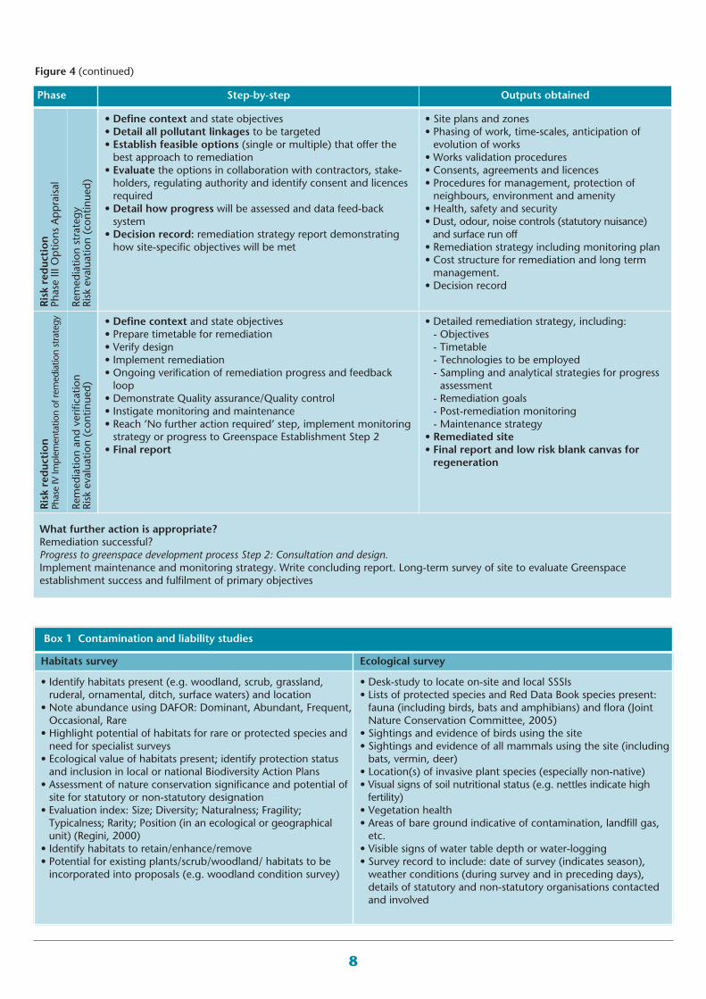
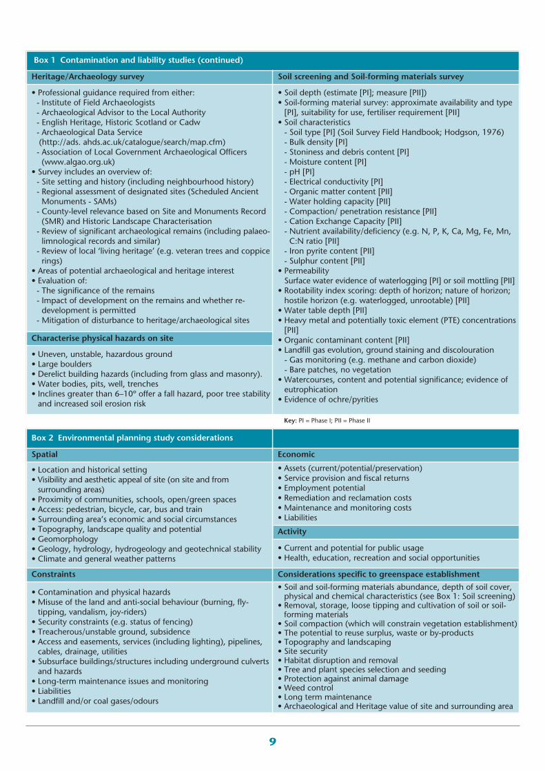
Box 1 Contamination and liability studies
Habitats survey Ecological survey
• Identify habitats present (e.g. woodland, scrub, grassland,ruderal, ornamental, ditch, surface waters) and location
• Note abundance using DAFOR: Dominant, Abundant, Frequent,Occasional, Rare
• Highlight potential of habitats for rare or protected species andneed for specialist surveys
• Ecological value of habitats present; identify protection statusand inclusion in local or national Biodiversity Action Plans
• Assessment of nature conservation significance and potential ofsite for statutory or non-statutory designation
• Evaluation index: Size; Diversity; Naturalness; Fragility;Typicalness; Rarity; Position (in an ecological or geographicalunit) (Regini, 2000)
• Identify habitats to retain/enhance/remove• Potential for existing plants/scrub/woodland/ habitats to beincorporated into proposals (e.g. woodland condition survey)
• Desk-study to locate on-site and local SSSIs• Lists of protected species and Red Data Book species present:fauna (including birds, bats and amphibians) and flora (JointNature Conservation Committee, 2005)
• Sightings and evidence of birds using the site• Sightings and evidence of all mammals using the site (includingbats, vermin, deer)
• Location(s) of invasive plant species (especially non-native)• Visual signs of soil nutritional status (e.g. nettles indicate highfertility)
• Vegetation health• Areas of bare ground indicative of contamination, landfill gas,etc.
• Visible signs of water table depth or water-logging• Survey record to include: date of survey (indicates season),weather conditions (during survey and in preceding days),details of statutory and non-statutory organisations contactedand involved
9
Key: PI = Phase I; PII = Phase II
Box 1 Contamination and liability studies (continued)
Heritage/Archaeology survey Soil screening and Soil-forming materials survey
• Professional guidance required from either:- Institute of Field Archaeologists- Archaeological Advisor to the Local Authority- English Heritage, Historic Scotland or Cadw- Archaeological Data Service (http://ads. ahds.ac.uk/catalogue/search/map.cfm)- Association of Local Government Archaeological Officers(www.algao.org.uk)
• Survey includes an overview of:- Site setting and history (including neighbourhood history)- Regional assessment of designated sites (Scheduled AncientMonuments - SAMs)- County-level relevance based on Site and Monuments Record(SMR) and Historic Landscape Characterisation- Review of significant archaeological remains (including palaeo-limnological records and similar)- Review of local ‘living heritage’ (e.g. veteran trees and coppicerings)
• Areas of potential archaeological and heritage interest• Evaluation of: - The significance of the remains- Impact of development on the remains and whether re-development is permitted- Mitigation of disturbance to heritage/archaeological sites
• Soil depth (estimate [PI]; measure [PII])• Soil-forming material survey: approximate availability and type[PI], suitability for use, fertiliser requirement [PII]
• Soil characteristics- Soil type [PI] (Soil Survey Field Handbook; Hodgson, 1976)- Bulk density [PI]- Stoniness and debris content [PI]- Moisture content [PI]- pH [PI] - Electrical conductivity [PI]- Organic matter content [PII]- Water holding capacity [PII]- Compaction/ penetration resistance [PII]- Cation Exchange Capacity [PII]- Nutrient availability/deficiency (e.g. N, P, K, Ca, Mg, Fe, Mn,C:N ratio [PII]- Iron pyrite content [PII]- Sulphur content [PII]
• PermeabilitySurface water evidence of waterlogging [PI] or soil mottling [PII]
• Rootability index scoring: depth of horizon; nature of horizon;hostile horizon (e.g. waterlogged, unrootable) [PII]
• Water table depth [PII]• Heavy metal and potentially toxic element (PTE) concentrations[PII]
• Organic contaminant content [PII]• Landfill gas evolution, ground staining and discolouration- Gas monitoring (e.g. methane and carbon dioxide)- Bare patches, no vegetation
• Watercourses, content and potential significance; evidence ofeutrophication
• Evidence of ochre/pyrities
Characterise physical hazards on site
• Uneven, unstable, hazardous ground• Large boulders• Derelict building hazards (including from glass and masonry).• Water bodies, pits, well, trenches• Inclines greater than 6–10º offer a fall hazard, poor tree stabilityand increased soil erosion risk
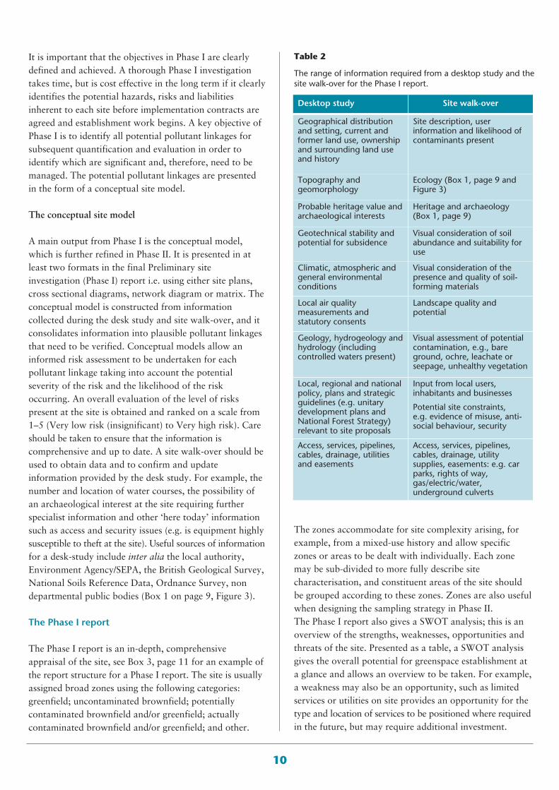
Economic
• Assets (current/potential/preservation)• Service provision and fiscal returns• Employment potential• Remediation and reclamation costs• Maintenance and monitoring costs• Liabilities
Activity
• Current and potential for public usage• Health, education, recreation and social opportunities
Considerations specific to greenspace establishment
• Soil and soil-forming materials abundance, depth of soil cover,physical and chemical characteristics (see Box 1: Soil screening)
• Removal, storage, loose tipping and cultivation of soil or soil-forming materials
• Soil compaction (which will constrain vegetation establishment)• The potential to reuse surplus, waste or by-products• Topography and landscaping• Site security• Habitat disruption and removal• Tree and plant species selection and seeding• Protection against animal damage• Weed control• Long term maintenance• Archaeological and Heritage value of site and surrounding area
Box 2 Environmental planning study considerations
Spatial
• Location and historical setting• Visibility and aesthetic appeal of site (on site and fromsurrounding areas)
• Proximity of communities, schools, open/green spaces• Access: pedestrian, bicycle, car, bus and train• Surrounding area’s economic and social circumstances• Topography, landscape quality and potential• Geomorphology• Geology, hydrology, hydrogeology and geotechnical stability• Climate and general weather patterns
Constraints
• Contamination and physical hazards• Misuse of the land and anti-social behaviour (burning, fly-tipping, vandalism, joy-riders)
• Security constraints (e.g. status of fencing)• Treacherous/unstable ground, subsidence• Access and easements, services (including lighting), pipelines,cables, drainage, utilities
• Subsurface buildings/structures including underground culvertsand hazards
• Long-term maintenance issues and monitoring• Liabilities• Landfill and/or coal gases/odours
10
Table 2
The range of information required from a desktop study and thesite walk-over for the Phase I report.
Desktop study Site walk-over
Geographical distributionand setting, current andformer land use, ownershipand surrounding land useand history
Site description, userinformation and likelihood ofcontaminants present
Topography andgeomorphology
Ecology (Box 1, page 9 andFigure 3)
Probable heritage value andarchaeological interests
Heritage and archaeology(Box 1, page 9)
Geotechnical stability andpotential for subsidence
Visual consideration of soilabundance and suitability foruse
Climatic, atmospheric andgeneral environmentalconditions
Visual consideration of thepresence and quality of soil-forming materials
Local air qualitymeasurements andstatutory consents
Landscape quality andpotential
Geology, hydrogeology andhydrology (includingcontrolled waters present)
Visual assessment of potentialcontamination, e.g., bareground, ochre, leachate orseepage, unhealthy vegetation
Local, regional and nationalpolicy, plans and strategicguidelines (e.g. unitarydevelopment plans andNational Forest Strategy)relevant to site proposals
Input from local users,inhabitants and businesses
Potential site constraints,e.g. evidence of misuse, anti-social behaviour, security
Access, services, pipelines,cables, drainage, utilitiesand easements
Access, services, pipelines,cables, drainage, utilitysupplies, easements: e.g. carparks, rights of way,gas/electric/water,underground culverts
It is important that the objectives in Phase I are clearlydefined and achieved. A thorough Phase I investigationtakes time, but is cost effective in the long term if it clearlyidentifies the potential hazards, risks and liabilitiesinherent to each site before implementation contracts areagreed and establishment work begins. A key objective ofPhase I is to identify all potential pollutant linkages forsubsequent quantification and evaluation in order toidentify which are significant and, therefore, need to bemanaged. The potential pollutant linkages are presentedin the form of a conceptual site model.
The conceptual site model
A main output from Phase I is the conceptual model,which is further refined in Phase II. It is presented in atleast two formats in the final Preliminary siteinvestigation (Phase I) report i.e. using either site plans,cross sectional diagrams, network diagram or matrix. Theconceptual model is constructed from informationcollected during the desk study and site walk-over, and itconsolidates information into plausible pollutant linkagesthat need to be verified. Conceptual models allow aninformed risk assessment to be undertaken for eachpollutant linkage taking into account the potentialseverity of the risk and the likelihood of the riskoccurring. An overall evaluation of the level of riskspresent at the site is obtained and ranked on a scale from1–5 (Very low risk (insignificant) to Very high risk). Careshould be taken to ensure that the information iscomprehensive and up to date. A site walk-over should beused to obtain data and to confirm and updateinformation provided by the desk study. For example, thenumber and location of water courses, the possibility ofan archaeological interest at the site requiring furtherspecialist information and other ‘here today’ informationsuch as access and security issues (e.g. is equipment highlysusceptible to theft at the site). Useful sources of informationfor a desk-study include inter alia the local authority,Environment Agency/SEPA, the British Geological Survey,National Soils Reference Data, Ordnance Survey, nondepartmental public bodies (Box 1 on page 9, Figure 3).
The Phase I report
The Phase I report is an in-depth, comprehensiveappraisal of the site, see Box 3, page 11 for an example ofthe report structure for a Phase I report. The site is usuallyassigned broad zones using the following categories:greenfield; uncontaminated brownfield; potentiallycontaminated brownfield and/or greenfield; actuallycontaminated brownfield and/or greenfield; and other.
The zones accommodate for site complexity arising, forexample, from a mixed-use history and allow specificzones or areas to be dealt with individually. Each zonemay be sub-divided to more fully describe sitecharacterisation, and constituent areas of the site shouldbe grouped according to these zones. Zones are also usefulwhen designing the sampling strategy in Phase II. The Phase I report also gives a SWOT analysis; this is anoverview of the strengths, weaknesses, opportunities andthreats of the site. Presented as a table, a SWOT analysisgives the overall potential for greenspace establishment ata glance and allows an overview to be taken. For example,a weakness may also be an opportunity, such as limitedservices or utilities on site provides an opportunity for thetype and location of services to be positioned where requiredin the future, but may require additional investment.
11
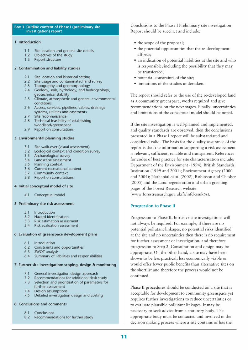
Conclusions to the Phase I Preliminary site investigationReport should be succinct and include:
• the scope of the proposal;• the potential opportunities that the re-development
affords;• an indication of potential liabilities at the site and who
is responsible, including the possibility that they maybe transferred;
• potential constraints of the site;• limitations of the studies undertaken.
The report should refer to the use of the re-developed landas a community greenspace, works required and giverecommendations on the next stages. Finally, uncertaintiesand limitations of the conceptual model should be noted.
If the site investigation is well-planned and implemented,and quality standards are observed, then the conclusionspresented in a Phase I report will be substantiated andconsidered valid. The basis for the quality assurance of thereport is that the information supporting a risk assessmentis relevant, sufficient, reliable and transparent. Referencesfor codes of best practice for site characterisation include:Department of the Environment (1994); British StandardsInstitution (1999 and 2001); Environment Agency (2000and 2004); Nathanial et al. (2002), Robinson and Chesher(2005) and the Land regeneration and urban greeningpages of the Forest Research website(www.forestresearch.gov.uk/fr/infd-5suk5s).
Progression to Phase II
Progression to Phase II, Intrusive site investigations willnot always be required. For example, if there are nopotential pollutant linkages, no potential risks identifiedat the site and no uncertainties then there is no requirementfor further assessment or investigation, and thereforeprogression to Step 2: Consultation and design may beappropriate. On the other hand, a site may have beenshown to be less practical, less economically viable orwould offer fewer public benefits than alternative sites onthe shortlist and therefore the process would not becontinued.
Phase II procedures should be conducted on a site that isacceptable for development to community greenspace yetrequires further investigations to reduce uncertainties orto evaluate plausible pollutant linkages. It may benecessary to seek advice from a statutory body. Theappropriate body must be contacted and involved in thedecision making process where a site contains or has the
Box 3 Outline content of Phase I (preliminary siteinvestigation) report
1. Introduction
1.1 Site location and general site details1.2 Objectives of the study1.3 Report structure
2. Contamination and liability studies
2.1 Site location and historical setting2.2 Site usage and contaminated land survey2.3 Topography and geomorphology2.4 Geology, soils, hydrology, and hydrogeology,
geotechnical stability2.5 Climate, atmospheric and general environmental
conditions2.6 Access, services, pipelines, cables. drainage
systems, utilities and easements2.7 Site reconnaissance2.8 Technical feasibility of establishing
woodland/greenspace2.9 Report on consultations
3. Environmental planning studies
3.1 Site walk-over (visual assessment)3.2 Ecological context and condition survey3.3 Archaeological survey3.4 Landscape assessment3.5 Planning context3.6 Current recreational context3.7 Community context3.8 Report on consultations
4. Initial conceptual model of site
4.1 Conceptual model
5. Preliminary site risk assessment
5.1 Introduction5.2 Hazard identification5.3 Risk estimation assessment5.4 Risk evaluation assessment
6. Evaluation of greenspace development plans
6.1 Introduction6.2 Constraints and opportunities6.3 SWOT analysis6.4 Summary of liabilities and responsibilities
7. Further site investigation: scoping, design & monitoring
7.1 General investigation design approach7.2 Recommendations for additional desk study7.3 Selection and prioritisation of parameters for
further assessment7.4 Design assumptions7.5 Detailed investigation design and costing
8. Conclusions and comments
8.1 Conclusions8.2 Recommendations for further study
12
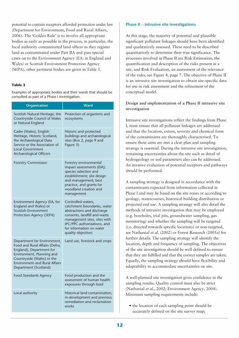
potential to contain receptors afforded protection under law(Department for Environment, Food and Rural Affairs,2006). The ‘Golden Rule’ is to involve all appropriatebodies as early as possible in the process, in particular, thelocal authority contaminated land officer as they registerland as contaminated under Part IIA and pass specialcases on to the Environment Agency (EA: in England andWales) or Scottish Environment Protection Agency(SEPA), other pertinent bodies are given in Table 3.
Phase II – intrusive site investigations
At this stage, the majority of potential and plausiblesignificant pollutant linkages should have been identifiedand qualitatively assessed. These need to be describedquantitatively to determine their true significance. Theprocesses involved in Phase II are Risk Estimation, thequantification and description of the risks present at asite, and Risk Evaluation, an assessment of the relevanceof the risks, see Figure 4, page 7. The objective of Phase IIis an intrusive site investigation to obtain site-specific datafor use in risk assessment and the refinement of theconceptual model.
Design and implementation of a Phase II intrusive siteinvestigation
Intrusive site investigations reflect the findings from PhaseI, must ensure that all pollutant linkages are addressedand that the location, extent, severity and chemical formof the contaminants are thoroughly characterised. Toensure these aims are met a clear plan and samplingstrategy is essential. During the intrusive site investigation,remaining uncertainties about the site such as detail ofhydrogeology or soil parameters also can be addressed.An iterative evaluation of potential receptors and pathwaysshould be performed.
A sampling strategy is designed in accordance with thecontaminants expected from information collected inPhase I and may be based on the site zones or according togeology, watercourses, historical building distribution orprojected end use. A sampling strategy will also detail themethods of intrusive investigation that may be employed(e.g. boreholes, trial pits, groundwater sampling, gasmonitoring) and whether the sampling will be targeted(i.e. directed towards specific locations) or non-targeted,see Nathanial et al. (2002) or Forest Research (2005a) forfurther details. The sampling strategy will identify thelocation, depth and frequency of sampling. The objectivesof the site investigation should be well defined to ensurethat they are fulfilled and that the correct samples are taken.Equally, the sampling strategy should have flexibility andadaptability to accommodate uncertainties on site.
A well-planned site investigation gives confidence in thesampling results. Quality control must also be strict(Nathanial et al., 2002; Environment Agency, 2004).Minimum sampling requirements include:
• the location of each sampling point should beaccurately defined on the site survey map;
Organisation Ward
Scottish Natural Heritage, theCountryside Council of Walesor Natural England
Protection of organisms andecosystems
Cadw (Wales), EnglishHeritage, Historic Scotland,the Archaeological DataService or the Association ofLocal GovernmentArchaeological Officers
Historic and protectedbuildings and archaeologicalsites (Box 2, page 9 andFigure 3)
Forestry Commission Forestry environmentalimpact assessments (EIA);species selection andestablishment; site designand management; bestpractice, and grants forwoodland creation andmanagement
Environment Agency (EA, forEngland and Wales) orScottish EnvironmentProtection Agency (SEPA)
Controlled waters,catchment boundaries, waterabstractions and dischargeconsents, landfill and wastemanagement sites, sites withIPC/PPC authorizations, andfor information on waterquality objectives
Department for Environment,Food and Rural Affairs (Defra;England), Department forEnvironment, Planning andCountryside (Wales) or theEnvironment and Rural AffairsDepartment (Scotland)
Land use, livestock and crops
Food Standards Agency Food production and theassessment of human healthexposures through food
Local authority Historical land contamination, re-development and previousremediation and reclamationworks
Table 3
Examples of appropriate bodies and their wards that should beconsulted as part of a Phase I investigation.
13
• clear evidence should be presented to show that asufficient number of samples were taken and that eachwas of sufficient size/volume;
• chain of custody guidelines for labelling, handling,storage and transport of samples should be adhered to;
• field conditions during the site survey should berecorded;
• precautions to protect the environment, prevent crosscontamination and prevent the creation of newpollutant linkages should be evident;
• health and safety concerns for the site surveyor(s) shouldbe evaluated prior to the survey being undertaken.
In addition, photographic evidence may be used tosupport site observations. Sources of further informationfor a site investigation include Environment Agency,(2004), British Standards Institution (1999 and 2001),Environment Agency (2000), and Nathanial et al. (2002).
Risk estimation
Risk estimation requires a comparison of representativesite concentrations for each pollutant to be made againstsoil guideline values (SGVs) to determine if the risks areunacceptable. A limited number of SGVs have beenpublished by the Environment Agency (see the Landcontamination web pages at www.environment-agency.gov.uk) these values shouldonly be used if the site under investigation closelyresembles the ‘model’ site described by the EnvironmentAgency for the purpose of deriving these published SGVs.
It is important that, where published SGVs are notapplicable to the site, site-specific values need to becalculated. To derive an SGV for any site, detailedinformation about each component of the pollutantlinkage is required, including:
• contaminant data: occurrence, chemical form andcharacteristics, location and concentration;
• soil properties: texture, organic matter content, pH,cation exchange capacity, bulk density and moisturecontent;
• toxicological data: acceptable background exposurerate, human toxicity of the pollutant in question,likely uptake or exposure rate versus acceptable/safeintake, routes of uptake.
The pollutant linkage and site information data is input toa risk assessment model to derive the SGV for that site.Subsequently, the derived SGV is statistically compared tothe representative site concentrations for the pollutant to
determine if the risks are unacceptable. Statistical analysesare an important part of the risk estimation process asthey enable the effect of data variability, which is inherentin an environmental setting and when sampling aheterogeneous material such as soil, to be considered.Statistical analyses also enable a degree of confidence inthe final assessment to be stated.
The types of models used in risk estimation are eitherGeneric or Detailed Quantitative Risk Assessment (GQRAor DQRA) models (Environment Agency, 2004). GQRAuses mainly generic, conservative assumptions aboutreceptors and pathways, and the characteristics andbehaviour of sources in its model algorithms. DQRAmodels are used when the generic assessment criteria (usedin GQRA) are not appropriate to a site or result inunacceptable uncertainties. GQRA models (such as theEnvironment Agency’s contaminated land exposureassessment (CLEA) model) relate only to chronic humanhealth risks, they do not relate to acute human healthrisks, to groundwater, ecosystems or the occupationalhealth of site workers during site investigations andremediation. Other limitations include:
• a limited range of conceptual model scenarios;• only three types of land use are defined – residential,
allotments and commercial/industrial; • the land is assumed to be derelict with no schools in
the vicinity;• limited numbers of contaminants are considered;• there is no allowance for on-site use of water;• CLEA assumes that there is no contaminant
degradation (Nathanial et al., 2002).
Although DQRA models also have their limitations, siteassessment should be performed in a DQRA model wheresite conditions are outside the generic, conservativestructure and limitations of GQRA models. An exampleof a DQRA model is the SNIFFER Framework (Methodfor deriving site-specific human health assessment criteriafor contaminants in soil, project reference LQ01,www.sniffer.org.uk). A worst-case scenario should alwaysbe assumed where there are uncertainties or datalimitations.
In summary, risk estimation involves a comparison ofrepresentative site contaminant concentrations withappropriate generic or site-specific assessment criteria toestimate the presence of unacceptable risks. Note that theGQRA and DQRA processes described above relate tohuman health only, and where environmental receptors(such as a great crested newt, an archaeological treasure
14
or a veteran tree) are present and potentially at risk,Natural England should be consulted and anenvironmental risk estimation should be performed.Depending on the site, risk estimations for both humanhealth and environmental risks may be required.
The quantitative risk assessment may require additionalinformation or further investigations to clarifyuncertainties. It should be remembered that each step inthe risk assessment process requires decisions to be madeon the basis of information collected about the site; forexample, the extent or location of potential contaminants.As more information is collected, the conceptual modelcan be refined, risk assessments re-evaluated andconclusions updated. This iterative approach helps toensure that the level of input at each stage of the riskassessment is appropriate and defensible.
Risk evaluation and concluding the Risk assessment
Risk evaluation is a process of collating the numbers,uncertainties and site conditions into an answer to theover-riding question of whether the risks are relevant. Foreach pollutant linkage identified, the potential ‘severity’ ofthe risk (ranked: minor, mild, medium or severe) is crosstabulated with the ‘probability’ of the risk occurring(ranked: unlikely, low likelihood, likely or high likelihood)to obtain an overall evaluation of the level of risk (afterRudland et al., 2001). The overall risk is then ranked 1–5(very low to very high) and this enables a consideration ofits acceptability to be made. As a general guide, all risksabove ‘low’ should be considered for further investigation,management or monitoring, although appropriatelyqualified personnel should always make these decisions ona site-by-site basis and by taking into account allinformation pertinent to the conceptual model.
In concluding a Phase II investigation, the report may adviseon exiting the assessment process, for example, because nosignificant pollutant linkages exist). Alternatively, if the riskmanagement process is to be continued to the next stage,the report should contain a revised conceptual site modelhighlighting all the significant pollutant linkages identifiedin the risk estimation that require management. A morein-depth evaluation of the potential of the site should alsobe detailed, updating the Phase I SWOT analysis. Finally,the report may suggest a Phase III Options appraisal tointroduce potential remediation strategies and offernotification of any licences that have to be applied for(e.g. discharge consents and waste management licences).An account of outstanding uncertainties, assumptions andsite limitations are imperative.
Risk Reduction
Phase III: options appraisal
Following the risk assessment processes (Phases I and II),a risk management strategy is required to address all ofthe significant pollutant linkages (as detailed in the refinedPhase II conceptual model) so that after remediation theywill be treated and/or removed (sometimes termed‘demonstrably broken’). Options Appraisal is a process toestablish the options that offer the best overall approachto remediation taking into consideration site specificcircumstances (Environment Agency, 2004). Optionsappraisal comprises three stages: identify feasible options;evaluate the options; and produce a remediation strategy.
Evaluating the options
Identification of feasible options is directly based uponPhase II and requires that all significant pollutant linkagesfor the site are known. Hence, thorough and detailedreporting for all phases is essential. The feasible optionsfor any remediation strategy will depend on several factors:
• The site characteristics (location, size, security, localusers, constraints to the establishment of a greenspaceas identified in the Phase I and II reports).
• The contaminants present, their concentration andchemical form, and the environmental matrix (air,soil, water) involved.
• The legal context of the remediation programme.• Stakeholder opinions.• Timescales.
These factors are site specific, as are the evaluations of theoptions and, therefore, are not covered in-detail in thisInformation Note. Environment Agency (2004) givesfurther information.
Remediation strategy
Following identification and evaluation of the options, theremediation strategy (also called a method statement)details works to be carried out, type and scale ofcontamination to be remediated, and the remediationmethodologies to be employed (remedial/protective/other).The purpose and scope of the work, together with the siteobjectives should be clearly presented in the strategy. A remediation strategy document will include:
• site plans and zoning;• phasing of work, approximate time-scales and an
15
anticipation of evolution or variations of plans arisingover the course of the works;
• works validation procedures;• consents, agreements and licences;• procedures for management and protection of
neighbours, environment and amenity;• health, safety and security issues;• matters of environmental health, including dust,
odour and noise controls;• surface water or liquid run-off;• a demonstration that the strategy meets the overall
site-specific objectives.
There are some additional points to the remediationstrategy applicable to the establishment of greenspace. Atthis stage in the site re-development process, draft plansfor the new design of the site, such as the types andlocations of habitats, should be available. The remediationstrategy needs to take into account the effect that theremediation will have on trees and plants, and the effectof those on the identified pollutant linkages; examples are:
1. Various methods of soil treatment for organiccontaminants de-nature the soil. For example, thermaltreatments or solvent washing techniques reducemacro and micro soil fauna populations, reduce thesoil organic matter content, and potentially leavewashing reagent residues in the soil. This is anexample of a negative impact of remediation on theability of the site to support vegetation.
2. Brownfield land is often characterised by compact,stony ground. The addition of organic matter such ascompost reduces bulk density (increasing aeration andthe water holding capacity), provides essentialnutrients to support soil biota and plant life, and maystabilise contaminants by sequestering (binding) heavymetals and organics. This is an example of a positiveimpact of remediation on the ability of the site tosupport vegetation.
3. An example of integrating the remediation andestablishment of vegetation processes is a site wherethe source is heavy metal contaminated soils, thereceptor is a nearby housing estate and the pathway iswind-blown dust. Tree planting is both greening and ameans of affecting the pollutant linkage/pathway(trapping air-borne dust, reducing wind speed blowingover the contaminated soils and limiting dust release,and uptake of heavy metals by the plants).
It is important to reiterate that any remediation strategy
should be designed carefully to prevent the creation ofnew pollutant linkages during the works. Similarly, theOptions appraisal must give due consideration, to thepotential effects of remediation of the receptors (e.g.surface waters should be protected against receivingcontaminated materials, soil or debris as suspendedsolids). Equally, the effects of remediation on thesurrounding environment should be considered (e.g.neutralising acidic waters that are the sustaining source ofan SSSI acid wetland).
Another important consideration is how vegetation willperform when planted in the soil inherent to the site or insoil forming materials. Remediation is likely to alter thechemical profile of the soil or other planting material.Selected analyses will give an indication of the ability ofthe site to sustain vegetation and the potential of theadditions or amendments to the soil to improve nutrition,soil structure and/or immobilise contaminants. It is costeffective to conduct soil sampling to determine chemicaland physical properties at the same time as the Phase IIIntrusive site investigation, although this may require theuse of different laboratories. Details of relevant analysesand target levels for both nutrients and contaminants aregiven in Forest Research (2005b; 2005c).
Regardless of the chemical nature of the soils they may beinadequate for supporting appropriate vegetation; this isparticularly the case on landfill sites established before theWaste Management Licensing regulations 1994 and theLandfill Regulations 1994 and 2002. It is thereforeimportant to take this in to account when creating theremediation strategy rather than identifying at a laterstage that there is a need to import additional materials tosupport the vegetation.
If the site has any archaeological interest the relevantstatutory body, English Heritage, Cadw (in Wales) orScottish Natural Heritage should be contacted, see the list ofstatutory bodies and their wards given in Table 3, page 12.
Phase IV: implementation of the remediationstrategy
The final phase in the risk management process is toimplement remediation and ensure that the remediationachieves the planned objectives, with appropriate qualityassurance. CLR 11 (Environment Agency, 2004) liststhree parts to implementation:
• prepare a plan design;• implement and verify remediation;
16
• long-term monitoring, and maintenance whererequired.
Implementation is a site-specific exercise usuallyundertaken by consultants and contractors. Verification isan on-going process during remediation, with feed-backloops (e.g. remediate – analyse – evaluate progress –proceed/work complete). In multi-partnership projects, aproject manager will ensure timely and efficientmanagement of the remediation strategy and will reportprogress to the stakeholders.
When the remediation is completed, a final report shouldbe produced, and should cover:
• background information;• methodologies employed;• compliance to regulatory permits held;• the analytical protocol employed;• the readiness for greenspace establishment ;• remediation success, detailing the final extent of the
work undertaken and the status of the contaminationupon completion;
• on-going monitoring required.
STEPS 2–4 OF GREENSPACEDEVELOPMENT: FROM CONSULTATION TOMANAGEMENT
The Forestry Commission requires that the establishmentof woodland and associated greenspace preserves andprotects important features of the landscape, cultural andnatural resource heritage, in accordance with bestpractice. Consequently, the potential and feasibility of asite for greenspace establishment is assessed and revisedregularly during the site selection, investigation andremediation works process. In effect, a greenspaceestablishment feasibility study is conducted alongside therisk assessment and management process (Phases I–IVdescribed above) and considers aspects such as:
• whether tree growth will adversely affect the site;• the types of habitats to be created at this site;• the species of trees and plants most appropriate for
the site.Forest Research will give guidance on many of thesepoints, e.g. native or non-native tree selection (ForestResearch, 2005d); soil cultivation and ripping (ForestResearch, 2005e). Also, the software package ‘ROOTS –
Software for greening brownfield land’, developed by theForestry Commission, gives specifications for all aspectsof site restoration, including nutrient requirements, weedcontrol and species selection; (www.roots-software.co.uk).
SStteepp 22:: CCoonnssuullttaattiioonn aanndd ddeessiiggnn
Following risk management and/or remediation to thesatisfaction of the regulating authority, usually the localauthority, reclamation of a site would proceed to Step 2:Consultation and design. Design is an iterative processbetween experts (landscape architects, engineers andscientists), site owners/managers and public stakeholdergroups that leads to the production of the master plan. Amaster plan reflects project aims and stakeholder desires.Examples may include: public benefit (improve health andwell-being, increase access, recreation and education),catalyse local regeneration, and promote environmentalimprovement (landscape, aesthetics and biodiversity).Deviations from projects aims or from local demand arelikely to be highlighted as part of the stakeholder–designerconsultation iteration, and must be suitably addressed toenhance the inclusive nature of greenspace provision.
Adopted ownership and involvement by the local communityin a greenspace is pivotal to the long-term success of agreenspace. Feelings of pride and ownership manifest inrespectful site use patterns and community engagement in,for example, volunteering and education events held onsite. Consultation with key stakeholders, including localcommunity groups, businesses and interest groups enablesdesires for the site to be considered and discussed whenimpractical (e.g. constrained by site topography, geography,hydrology or history). Providing a site that is appealinghelps ensure that it is well used and well looked after. Toassist in design, Forest Research Best Practice GuidanceNotes provide advice on tree species selection andmaximising biodiversity. Forestry Commission‘Guidelines’ are another helpful reference source in Step 2:Consultation and design (Forestry Commission, 1991).
Step 3: Implementation and delivery
Implementation and delivery, builds upon the SWOTanalysis created and refined in the Phase I and II reports.Delivery encompasses civil engineering of infrastructurethrough to provision of facilities and services, groundpreparation, planting and fencing. Wherever possible,delivery must actively involve all stakeholders, especiallythe local community, to promote the fostering of ownership.Constraints and limitations to the delivery programme areidentified during the design phase, enabling bottle-necks
17
to be appropriately time-tabled. For example, habitats orspecies may require protection during delivery to minimisedisturbance or may cause works to cease completely atcertain times of the year, such as in the breeding birdsseason. Restricted access areas are useful in such cases.Floral and faunal considerations include: trees withpreservation orders, bryophytes, certain mammals (suchas dormice and badgers), all breeding birds, reptiles,amphibians and many insects. In all cases, licenses from theappropriate statutory body must be obtained; such require-ments should be anticipated during Step 2: Consultationand design. Specific guidance can be obtained fromNatural England, Department for Environment, Food andRural Affairs (Defra) and your local authority.
Forest Research Best Practice Guidance Notes detail adviceand minimum standards acceptable for the establishmentof greenspaces. Further guidance on establishing robustgreenspaces in the urban environment and working withcommunities is provided by the BTCV (Agate, 2002).
Step 4: Management and maintenance
Step 4 extends beyond the establishment of a greenspaceto management, monitoring and maintenance and the on-going processes of pest control, health and safetyassessments, habitat care, and community liaison. Postregeneration a new greenspace requires management inthe short- (e.g. weed control, tree protection), medium-(e.g. pest control) and long-term (e.g. path maintenance,health and safety check on trees and recreational facilitiesand silviculture). Maintaining the site in a manner that isappealing and safe for communities to enjoy increases useand helps minimise anti-social behaviour. Managementalso includes stewardship to promote biodiversity andmaintain habitats in the designed state. Managementplans written according to the site priorities assist in thesematters and help to resolve potentially conflicting uses, forexample recreational use close to areas that are designedfor wildlife. Community engagement and volunteeringshould be encouraged to promote site sustainability.
CONCLUSIONS
Site investigations follow a risk based assessment that hasbeen designed to be a practical, achievable and protectiveprocess for investigating land contamination whichenables informed, defensible decisions to be made. Theprocess rationalises site hazards to offer phased negotiablerisk management based on priorities. Although theprocess is potentially long, costly and complex, some steps
are not required for many brownfield sites being re-developed as community greenspace. It is thereforeimportant to undertake each step and phase thoroughly toallow the identification of opportunities to exit the riskmanagement process and proceed with reclamation andestablishment, in the knowledge that key decisions werecorrect, accountable and valid. Finally, it is important thatthe suitability of a site for greenspace establishment isthoroughly assessed and appropriately demonstrated andit is recommended that the checklist given on page 20 isused to ensure that all appropriate information is collected.
REFERENCES
AGATE, E. (2002).The urban handbook: a practical guide to communityenvironmental work. BTCV, Wallingford, Oxon.
BRITISH STANDARDS INSTITUTION (1999).Code of practice for site investigations. BS 5930:1999.BSI, London
BRITISH STANDARDS INSTITUTION (2001).Investigation of potentially contaminated site. Code ofpractice. BS 10175:2001. BSI, London.
DEPARTMENT FOR COMMUNITIES AND LOCALGOVERNMENT (2006).Housing. Planning Policy Statement 3. TSO, London.
DEPARTMENT FOR ENVIRONMENT, FOOD ANDRURAL AFFAIRS (2006).Defra circular 01/2006 environmental protection act 1990:Part 2A contaminated land September 2006. Defra, London.
DEPARTMENT FOR ENVIRONMENT, FOOD ANDRURAL AFFAIRS (2007).A strategy for England’s trees, woods and forests.DEFRA, London.
DEPARTMENT OF THE ENVIRONMENT (1994).Contaminated land report 2 – guidance on preliminarysite inspection of contaminated land. EnvironmentAgency, Bristol.
ENVIRONMENT AGENCY (2000).Technical aspects of site investigation in relation to landcontamination. R&D Technical Report P5-065TR.Environment Agency, Bristol.
ENVIRONMENT AGENCY (2004).Model procedures for the management of landcontamination. Contaminated Land Report 11.Environment Agency, Bristol.

18
FOREST RESEARCH (2005a). Soil sampling strategies for derelict, underused andneglected land prior to greenspace establishment. Best Practice Guidance Note 1. Land Regeneration and Urban Greening Group, Farnham.
FOREST RESEARCH (2005b). Laboratory analysis of soils and spoils. Best Practice Guidance Note 2. Land Regeneration and Urban Greening Group, Farnham.
FOREST RESEARCH (2005c). Imported soil or soil-forming materials placement. Best Practice Guidance Note 5. Land Regeneration and Urban Greening Group, Farnham.
FOREST RESEARCH (2005d). Native and non-native trees: how and why to choose. Best Practice Guidance Note 8.Land Regeneration and Urban Greening Group, Farnham.
FOREST RESEARCH (2005e). Do you need to cultivate?Best Practice Guidance Note 3.Land Regeneration and Urban Greening Group, Farnham.
FORESTRY COMMISSION (1991).Community woodland design guidelines. Forestry Commission, Edinburgh.
FORESTRY COMMISSION SCOTLAND (2006).The Scottish forestry strategy. Scottish Executive, Edinburgh.
FORESTRY COMMISSION WALES (2001).Woodlands for Wales: the National Assembly for Walesstrategy for trees and woodlands.National Assembly for Wales, Aberystwyth.
HODGSON, J.M. (1976)Soil Survey field handbook: describing and sampling soilprofiles. Technical Monograph 5.Soil Survey of England and Wales, Harpenden, Herts.
HUTCHINGS, T. (2002).The opportunities for woodland on contaminated land.Forestry Commission Information Note 44. Forestry Commission, Edinburgh.
JOINT NATURE CONSERVATION COMMITTEE (2005).Red data books. (List on website)www.jncc.gov.uk/page-2133
MOFFAT, A.J. and McNEILL, J.D. (1994).Reclaiming disturbed land for forestry. Forestry CommissionBulletin 110. Forestry Commission, Edinburgh.
Enquiries relating to this publication should be addressed to:
Kieron DoickEnvironmental and Human Sciences DivisionForest ResearchAlice Holt LodgeFarnhamSurrey GU10 4LH
T: 01420 22255F: 01420 520180E: [email protected]
www.forestresearch.gov.uk
NATHANAIL, J., BARDOS, P. and NATHANAIL, P.(2002).Contaminated land management: ready reference. LandQuality Press/EPP Publications Ltd,Nottingham/Chiswick.
OFFICE OF THE DEPUTY PRIME MINISTER (2003).Sustainable communities: building for the future. ODPM, London.
OFFICE OF THE DEPUTY PRIME MINISTER (2004).Planning and pollution control. Planning Policy Statement23. TSO, London.
OFFICE OF THE DEPUTY PRIME MINISTER (2005).Biodiversity and geological conservation. Planning PolicyStatement 9. TSO, London.
PUBLIC BENEFIT RECORDING SYSTEM (2006).The Public Benefit recording System briefing note.NWDA (North West Regional DevelopmentAgency)/Forestry Commission England/TEP.www.pbrs.org.uk
REGINI, K. (2000).Guidelines for ecological evaluation and impactassessment. In Practice, Bulletin of the Institute of Ecologyand Environmental Management no. 29.
ROBINSON, C. and CHESHER, L. (2005).Specification for: Phase 1 site investigation. ForestryCommission England, Land Regeneration Unit, Stafford.www.forestresearch.gov.uk/pdf/LRUFRPhase1specification12.pdf/$FILE/LRUFRPhase1specification12.pdf
RUDLAND, D.J., LANCEFIELD, R.M. and MAYELL,P.N. (2001)Contaminated land risk assessment: a guide to goodpractice. C552. CIRIA (Construction Industry Researchand Information Association), London.
19
Appendix
Summary of ‘Harm Tables’ (adapted from Tables A and B, Annex 3, Defra Circular 01/2006, Department for Environment, Food andRural Affairs, 2006).
Type of receptor Description of categories of significant harm(after Table A of Circular 01/2006)
Description of conditions of significantpossibility of significant harm
(after Table B of Circular 01/2006)
Human beings • Death• Disease• Serious injury• Genetic mutation• Birth defects • Impairment of reproductive functions.
For these purposes, disease is an unhealthycondition of the body or a part of it and caninclude, e.g., cancer, liver dysfunction orextensive skin ailments. Mental dysfunction isincluded only insofar as it is attributable to theeffects of a pollutant on the body.
In this Chapter, this description of significantharm is referred to as a ‘human health effect’.
An assessment should take into account:• likely total intake or exposure; • relative contribution of the pollutant linkageto the aggregate intake or exposure;
• duration of intake or exposure • toxicological properties includingcarcinogenic, mutagenic, teratogenic,pathogenic, endocrine-disrupting
Harm which: • would be irreversible or incapable of beingtreated;
• would result from a single incident such as afire;
• would be likely to result from a chronicexposure.
Assessment is independent of the number ofpeople who might be affected.
Any ecological system or livingpart of an ecological system:• an SSSI; • a national nature reserve; • a marine nature reserve; • an area of special protectionfor birds;
• a Special Area ofConservation or a SpecialProtection Area
• a listed Ramsar site • a National Park/reserve
For any protected location:• harm which results in an irreversible orsubstantial adverse change in thefunctioning of the ecological system withinany substantial part of that location; or
• harm which affects any species of specialinterest within that location and whichendangers the long-term maintenance of thepopulation of that species at that location.
This description of significant harm is referredto as an ‘ecological system effect’.
If:• significant harm is more likely than not toresult from the pollutant linkage in question;
• there is a reasonable possibility of significantharm being caused, and if that harm were tooccur, it would result in such a degree ofdamage at the location that it would be beyondany practicable possibility of restoration;
taking into account relevant information forthe type of pollutant linkage, particularly inrelation to the ecotoxicological effects of thepollutant.
Property (I) in the form of: • crops, including timber; • produce grown domestically,or on allotments, forconsumption;
• livestock; • other owned ordomesticated animals;
• wild animals which are thesubject of shooting or fishingrights.
For crops: substantial diminution in yield orloss in value resulting from death, disease ordamage.
For domestic pets or other property in thiscategory, death, serious disease or seriousphysical damage.
Substantial loss in value occurs only when asubstantial proportion of the animals or cropsare dead or otherwise no longer fit for theirintended purpose. A benchmark for diminutionin yield or loss is taken to be 20% or greater.
If significant harm of that description is morelikely than not to result from the pollutantlinkage in question, taking into accountrelevant information for that type of pollutantlinkage, particularly in relation to theecotoxicological effects of the pollutant.
Property (II) in the form ofbuildings, where "building"means any structure orerection, and any part of abuilding including any partbelow ground level, but doesnot include plant or machinerycomprised in a building.
Structural failure.
Substantial damage or substantial interference(when any part of the building ceases to becapable of being used for the purpose forwhich it is or was intended).
In the case of a Scheduled Ancient Monument,substantial damage should be regarded asoccurring when the damage significantlyimpairs the historic, architectural, traditional,artistic or archaeological interest for which themonument was scheduled.
If significant harm of that description is morelikely than not to result from the pollutantlinkage in question during the expectedeconomic life of the building (or, in the case ofa Scheduled Ancient Monument, theforeseeable future), taking into accountrelevant information for that type of pollutantlinkage.
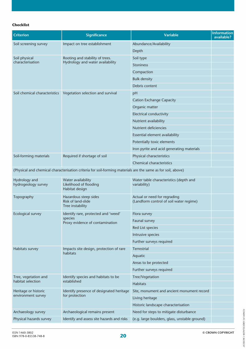
20© CROWN COPYRIGHTISSN 1460-3802
ISBN 978-0-85538-748-8
FCIN091/FC
-GB(EC
D)/ALDR-1.5K/D
EC07
Checklist
Criterion Significance Variable Informationavailable?
Soil screening survey Impact on tree establishment Abundance/Availability
Depth
Soil physicalcharacterisation
Rooting and stability of trees.Hydrology and water availability
Soil type
Stoniness
Compaction
Bulk density
Debris content
Soil chemical characteristics Vegetation selection and survival pH
Cation Exchange Capacity
Organic matter
Electrical conductivity
Nutrient availability
Nutrient deficiencies
Essential element availability
Potentially toxic elements
Iron pyrite and acid generating materials
Soil-forming materials Required if shortage of soil Physical characteristics
Chemical characteristics
(Physical and chemical characterisation criteria for soil-forming materials are the same as for soil, above)
Hydrology and hydrogeology survey
Water availabilityLikelihood of floodingHabitat design
Water table characteristics (depth andvariability)
Topography Hazardous steep sidesRisk of land-slideTree instability
Actual or need for regrading(Landform control of soil water regime)
Ecological survey Identify rare, protected and ‘weed’species Proxy evidence of contamination
Flora survey
Faunal survey
Red List species
Intrusive species
Further surveys required
Habitats survey Impacts site design, protection of rarehabitats
Terrestrial
Aquatic
Areas to be protected
Further surveys required
Tree, vegetation and habitat selection
Identify species and habitats to beestablished
Tree/Vegetation
Habitats
Heritage or historicenvironment survey
Identify presence of designated heritagefor protection
Site, monument and ancient monument record
Living heritage
Historic landscape characterisation
Archaeology survey Archaeological remains present Need for steps to mitigate disturbance
Physical hazards survey Identify and assess site hazards and risks (e.g. large boulders, glass, unstable ground)