Embed Size (px)
Citation preview

CARLSMITH BALL LLP
B. MARTIN LUNAOne Main Plaza, Suite 4002200 Main StreetWailuku, Maui, Hawaii 96793Tel. No.: (808) 242-4535Facsimile No.: (808) 244-4974
0865C2ÿ
!
r'-
>--t (24rv! ÿ, r :
PÿCD-*rt (-3
GREGORY K. SCHLAISASB Tower, Suite 22001001 Bishop StreetHonolulu, Hawaii 96813Tel. No.: (808) 523-2500Facsimile No.: (808) 523-0842
>
..J
BEFORE THE LAND USE COMMISSION
Attorneys for PetitionerWAIKO INDUSTRIAL INVESTMENT, LLC
9042 >Cr;
OF THE STATE OF HAWAII
In the Matter of the Petition of
WAIK() INDUSTRIAL INVESTMENT, LLC
To Amend the Land Use District Boundary ofCertain Lands Situated at Waikapu, Wailuku,Island of Maui, State of Hawai'i, Consisting ofapproximately 31.222 Acres, from theAgricultural District to the Urban District, TaxMap Key No. (2) 3-8-007:102.
DOCKET NO. A12-796
WAIKO INDUSTRIAL INVESTMENT, LLC'SFIRST AMENDMENT TO PETITION FOR
DISTRICT BOUNDARY AMENDMENT FILED SEPTEMBER 13ÿ 2012
VERIFICATION
APPENDIX J-1 AND EXHIBITS "9"ÿ "10" AND "11"
CERTIFICATE OF SERVICE
4845 -4063 -3105.1.065195 -00001

BEFORE THE LAND USE COMMISSION
OF THE STATE OF HAWAII
In the Matter of the Petition of DOCKET NO. A12-796
WAIKO INDUSTRIAL INVESTMENT, LLC
To Amend the Land Use District Boundary ofCertain Lands Situated at Waikapu, Wailuku,Island of Maui, State of Hawai'i, Consisting ofapproximately 31.222 Acres, from theAgricultural District to the Urban District, TaxMap Key No. (2) 3-8-007:102.
WAIKO INDUSTRIAL INVESTMENT, LLC'SFIRST AMENDMENT TO PETITION FOR
DISTRICT BOUNDARY AMENDMENT FILED SEPTEMBER 13ÿ 2012
COMES NOW, PETITIONER WAIKO INDUSTRIAL INVESTMENT, LLC
("Petitioner"), a Washington limited liability company, by and through its attorneys,
CARLSMITH BALL LLP, and hereby submits the following amendment to the Petition for
District Boundary Amendment which was filed with the State Land Use Commission
("Commission") on September 13, 2012 (hereinafter referred to as the "Petition").
Petitioner respectfully submits this first amendment to the Petition pursuant to
section 15-15-43, Hawaii Administrative Rules ("HAR"), which states in relevant part:
... All pleadings may be amended at any time until forty-five days prior to the hearing date set pursuant to section 15-15-51.Amendments offered prior to the hearing date shall be served onall parties and filed with the commission. All parties shall have theopportunity to provide any further response to address theamended pleading up to thirty days prior to the hearing date setpursuant to section 15-15-51.
4845-4063-3105.1.065195-00001

A. INTRODUCTION
On September 13, 2012, Petitioner filed a Petition for District Boundary
Amendment to reclassify approximately 31.22 acres from the Agricultural District to the Urban
District in Commission Docket No. A12-796.
Subsequent to filing the Petition, the Executive Officer of the Commission
requested Petitioner to provide additional information about six (6) matters relating to the
Petition and to supplement certain provisions pertaining to assessments of potential impacts that
may occur due to the reclassification of the Petition Area, prompting the submission of this
Amendment to the Petition.
B. AMENDED AND SUPPLEMENTED SECTIONS
Petitioner is providing additional information to and supplementing Sections X,
XII, XIII, XIV, XIX and XXI of the Petition as follows:
X. LOCATION OF THE PROPOSED DEVEI,OPMENT TOADJACENT LAND USE DISTRICTS AND CENTERS OFTRADING AND EMPLOYMENT
The Map, designated as Petitioner's Exhibit "9", attached hereto and by
reference made a part hereof, shows the location of the proposed development in relation to
adjacent land use districts.
XII. IMPACTS OF THE PROPOSED DEVEI,OPMENT ON THEENVIRONMENT
The Memorandum by Tom Nance of Tom Nance Water Resource Engineering,
dated October 1, 2012, designated as Petitioner's Exhibit "10", attached hereto and by
reference made a part. hereof, provides additional information relating to the impact of the
Project upon the groundwater of the Kahului Aquifer System which serves a portion of Central
Maui, including the Waiko/Waiale/Maui Lani area.
4845-4063-3105.1.065195-00001 2.

XIII. IMPACTS OF THE PROPOSED DEVELOPMENT ONAVAILABILITY OR ADEQUACY OF PUBLIC SERVICES ANDFACILITIES
The Maui County Civil Defense Agency is responsible for administering and
operating the various local, state and federal civil defense programs for the County of Maui.
This includes planning, preparing and coordinating civil defense operations in meeting disaster
situations and coordinating post-disaster recovery operations. According to the Maui County
Civil Defense Agency, an existing emergency siren for the Waikapu area is located at the
Waikapu Community Center, approximately a quarter of a mile mauka or west of the Project. A
map designated as Petitioner's Exhibit "11", attached hereto and by reference made a part
hereof, depicts the location of the existing civil defense siren.
XIV. ECONOMIC IMPACTS OF THE PROPOSEDRECLASSIFICATION OR DEVELOPMENT
As noted in the FEA, the Project is not considered a population generator and will
not affect population parameters within the Wailuku-Kahului Community Plan region.
Therefore, the Project will not have any impact on higher/lower education, human services and
recreation. Other public services such as police, fire, and emergency medical services, are
currently servicing the Waikapu region and the Project would not trigger the extension of the
current limits of service.
Furthermore, there will be no public funds to be used in the development of the
Project. Water and wastewater services will be provided by a private system built and paid for
by the Petitioner. Similarly, roadway improvements that are required by the County for the
Project will be constructed by the Petitioner at its own expense in compliance with the applicable
County and State rules and regulations. In addition, solid waste disposal generated from the
Project will be hauled by privately-owned commercial haulers.
4845-4063-3105.1.065195-00001 3.

Since the Project does not require any County or State funds for any
improvements of the Project, there are no anticipated impacts on government debt service and
government employee benefits.
XIX. HAWAIIAN CUSTOMARY AND TRADITIONAL RIGHTS
Petitioner is aware of, and is sensitive to, the protections afforded to Native
Hawaiian customary and traditional rights under Article XII, section 7 of the Hawai'i State
Constitution. Based on the results of the Cultural Impact Assessment, previous research, and the
archaeological assessment survey, no direct evidence was encountered that indicates that Native
Hawaiians had customarily and traditionally exercised for subsistence, cultural and religious
purposes on this 31.222-acre portion of land in Waikapu. However, it is important to note that
stream deposits were located in some test instances, indicating that water was available at
different times in the past, possibly when Hawaiians lived in this general area. Given the level of
intensive disturbance over the past several decades, including more recent sand-mining activities
in the 1970s and 1980s, Hawaiian flora that may once have been in the general area has
essentially been eliminated. The State Historic Preservation Division has previously approved
an archaeological monitoring plan to help mitigate potential adverse effects of the proposed
project on any undocumented site(s) that may potentially be contained within the subject parcel.
In addition, Petitioner intends to follow the recommendations provided in the CIA and
Archaeological Inventory Survey in the development of the proposed Waikÿ Industrial
Subdivision.
XXI. SERVICE AND NOTIFICATION OF PETITION FILING
Pursuant to HAR § 15-15-48(a), copies of this Petition must be served upon the
County of Maul Planning Department and Planning Commission, the State of Hawai'i Office of
4845-4063-3105.1.065195-00001 4.
Planning, and all persons with a property interest in the Petition Area as recorded in the County's
real property tax records at the time this Petition is filed.
The County of Maui has a perpetual nonexclusive easement over a portion of the
Petition Area, granted by Easement dated April 30, 1991, recorded in the Bureau of
Conveyances of the State of Hawaii as Document No. 92-134141. Pursuant to Section 8-2.3 of
the Charter of the County of Maui, Petitioner served a copy of the Petition upon the Patrick K.
Wong, Esq., Corporation Counsel of the County of Maul, as the legal representative of the
County of Maui, including, but not limited to, all departments, and all boards and commissions,
on September 13, 2012.
Additionally, discussion has been initiated with the County for the relocation of
the easement within the Petition Area, and the Department of Environmental Management which
is charged by the County to oversee the former County landfill, which the easement connects to
Waiko Road, had no comments to the Draft Environmental Assessment that showed the
relocation of the easement in the Petition Area.
C. UPDATED APPENDIX AND NEW EXHIBITS
Petitioner respectfully submits the following updated appendix and new exhibits
in connection with this First Amendment to Petition:
Appendix J-1
Exhibit "9"
Exhibit "10"
Preliminary Engineering Report prepared by OtomoEngineering, Inc., dated May 2011, attached as Appendix Jto Petitioner's FEA (Petitioner's Exhibit "1"). The coverpage of Appendix J was updated to include the preparer'sname and engineer's stamp.
Map Showing Location of the Proposed Development inRelation to Adjacent Land Use Districts
Memorandum from Tom Nance of Tom Nance WaterResource Engineering to Vince Bagoyo dated October 1,2012
4845-4063-3105.1,065195-00001 5.

Exhibit "11" Map Depicting Location of Existing Civil Defense Siren
All other exhibits stated in the Petition for District Boundary Amendment are
current and not affected by the supplemental information in this First Amendment to Petition.
CONCLUSION
Based on the foregoing, Petitioner respectfully requests that the Commission finds
that this Petition complies with the necessary requirements of a petition for boundary amendment
pursuant to HAR § 15-15-50.
DATED: Wailuku, Hawaii, October ÿ ,2012.
B. MARTIN LUNAGREGORY K. SCHLAIS
Attorneys for PetitionerWAIKO INDUSTRIAL INVESTMENT, LLC
4845-4063-3105.1.065195-00001 6.

BEFORE THE LAND USE COMMISSION
OF THE STATE OF HAWAII
In the Matter of the petition of DOCKET NO. A12-796
WAIKO INDUSTRIAL INVESTMENT, LLC
To Amend the Land Use District Boundary ofCertain Lands Situated at Waikapu, Wailuku,Island of Maul, State of Hawaii, Consisting ofapproximately 31.222 Acres, from theAgricultural District to the Urban District, TaxMap Key No. (2) 3-8-007:102.
VERIFICATION
I, B. MARTIN LUNA, declare that:
1. I am an attorney for Petitioner WAIKO INDUSTRIAL INVESTMENT,
LLC in the above-captioned matter;
2. I have read the foregoing First Amendment to Petition for District
Boundary Amendment Filed September 13, 2012; know the contents thereof; and that the
contents therein contained are true to the best of my knowledge, information and belief; and
3. I declare under penalty of law that the foregoing is true and correct.
DATED: Wailuku, Hawaii, October ÿ ,2012.
B. MARTIN LUNA
Attorney for PetitionerWAIKO INDUSTRIAL INVESTMENT, LLC
4845-4063-3105.1.065195-00001

PRELIMINARY ENGINEERING REPORT
FOR
WAIKO INDUSTRIAL BASEYARD
Waikapu, Wailuku, Maui, Hawaii
T.M.K.: (2) 3-8-007:102
Prepared for:
Waiko Industrial Investment, LLCc/o 1300 N. Holopono Street, Suite 201
Kihei, Maui, Hawaii 96753
..ENÿ.LN.EEÿ_ / ÿ!
Prepared by:
OTOMOENGINEERING, INC,
CONSULTING CIVIL ENGINEERS305 SOUTH HIGH STREET, SUITE ] 02WAILUKU, MAUl, HAWAII 96793PHONE: (808) 242-0032FAX: (808) 242-5779
May 2011

TABLE OF CONTENTS
1.0 INTRODUCTION
2.0 EXISTINGINFRASTRUCTURE
2.1 ROADWAYS
2.2 DRAINAGE
2.3 SEWER
2.4 WATER
2.5 ELECTRIC AND TELEPHONE
3.0 ANTICIPATED INFRASTRUCTURE IMPROVEMENTS
3.1 ROADWAYS
3.2 DRAINAGE
3.3 SEWER
3.4 WATER
3.5 ELECTRIC AND TELEPHONE
EXHIBITS
1
2
3
4
LOCATION MAP
VICINITY MAP
SOIL SURVEY MAP
FLOOD INSURANCE RATE MAP
APPENDICES
A
B
C
HYDROLOGIC CALCULATIONS
WATER DEMAND CALCULATIONS
WASTEWATER CALCULATIONS

PRELIMINARY ENGINEERING REPORTFOR
WAIKO INDUSTRIAL BASEYARDT.M.K.: (2) 3-8-007:102
1.0 INTRODUCTION
The purpose of this report is to provide information on the existing
infrastructure which will be servicing the proposed project. It will also evaluate
the adequacy of the existing infrastructure and anticipated improvements whichmay be required for the proposed project.
The subject parcel is identified as T.M.K.: (2) 3-8-007: 102, and
encompasses an area of approximately 31.22 acres. It is also known as Lot 1-
C of the Kopaa Subdivision No. 2. It is bordered by undeveloped land to the
north, a cattle feed lot and Kuihelani Highway to the east, Waiko Road to the
south, and undeveloped land to the west. The southwesterly end of the parcel
is being used to raise cattle. The parcel is U-shaped and surrounds three sides
of the Consolidated Baseyard Subdivision. A roadway leading to the Campaign
Recycle Maui Composting Center traverses along the western boundary of the
project site. Existing overhead utility lines are located within the property and
along a portion of the northern boundary. A portion of the western section of
the parcel is currently being used to raise cattle and as a construction baseyardfor Fong Construction Company.
A & B Hawaii, Inc. is planning their Waiale Project to the north of the project
site and to the south of Waiko Road. It will be a village concept with mixed
uses. Immediately to the north of the project site, VMX and multi-family usesare being proposed.
The proposed project consists of developing thirty-seven industrial lots,
ranging in size from approximately 10,000 square feet to 78,000 square feet
and a commercial lot of approximately 8.4 acres. Proposed improvements
include paved roadways, concrete curb, gutter and sidewalk; private water
system, and landscaping. Underground water, sewer, drainage, electrical, and
telephone systems will also be constructed.
2.0 EXISTING INFRASTRUCTURE
2.1 ROADWAYS
Honoapiilani Highway is located approximately 4,000 feet west of the project
site. It is a two-lane undivided State Highway which runs in the north-south
1

direction into Wailuku town. The speed limit is 35 miles per hour (mph) in the
vicinity of Waiko Road. The Waiko Road intersection is signalized with existingleft turn pockets into East and West Waiko Road.
Kuihelani Highway is located immediately east of the project site. It is a two-
way, four-lane divided State arterial highway which also runs in a north-south
direction. The posted speed limit on Kuihelani Highway at Waiko Road is 55
mph. There is an existing traffic signal at the Kuihelani Highway-Waiko Road
intersection. The southern terminus of Kuihelani Highway is its intersection with
Honoapiilani Highway. The northern terminus is at its intersection with PuuneneAvenue, where it turns into Dairy Road.
Waiko Road is a two-lane County collector roadway that connects
Honoapiilani Highway and Kuihelani Highway. The posted speed limit on Waiko
Road is 20 mph. Immediately east of Honoapiilani Highway, Waiko Road
provides access to a residential community. Further east, Waiko Road provides
access to industrial and livestock land uses. There is a weight limit of 10,000
pounds from vehicles entering and exiting Waiko Road from HonoapiilaniHighway.
Waiale Road is a two-lane road with its southern terminus at Waiko Road.
It turns into Lower Main Street near Kaahumanu Avenue. The section of
Waiale Road from Waiko Road to Kuikahi Drive is privately owned. The
segment from Kuikahi Drive to Lower Main Street is County owned and used asa collector road.
Access to the project site will be from Waiko Road.
2.2 DRAINAGE
As previously mentioned, the subject parcel is U-shaped with a 60-foot wide
strip separating the western and eastern sections of the parcel. The western
section of the parcel slopes down in a west to east direction ranging in elevation
from approximately 272 feet to 232 feet above mean sea level, with an average
slope of approximately 3.0%. The eastern section of the parcel slopes down in
a west to east direction ranging in elevation from approximately 208 feet to 198
feet above mean sea level, with an average slope of approximately 2.2%. The
60-foot section separating the western and eastern sections of the parcel slopes
down in a west to east direction ranging in elevation from approximately 232
feet to 208 feet above mean sea level, with an average slope of approximately2.0%.

According to the "Soil Survey of Islands of Kauai, Oahu, Maui, Molokai, and
Lanai, State of Hawaii (August, 1972)," prepared by the United States
Department of Agriculture Soil Conservation Service, the soil within the project
site is classified as Puuone sand (PZUE). It is characterized as having rapid
permeability above the cemented layer, slow runoff and a moderate to severewind erosion hazard.
Presently, onsite surface runoff sheet flows across the western section of the
parcel in a west to east direction. A portion of the runoff sheet flows into an
existing pond located near the northern boundary. The pond is a depression
in the ground between 5 and 6 feet deep. The remainder of the runoff
eventually sheet flows toward the 60-foot section of the parcel separating the
western and eastern sections. Runoff from the 60-foot section of the parcel
sheet flows in a west to east direction and eventually into the adjacent
undeveloped properties. Runoff from the eastern section of the parcel sheet
flows in a west to east direction. Eventually all of the onsite runoff sheet flowsinto the Kuihelani Highway right-of-way.
There are two existing grated inlet catch basins at the intersection of Waiko
Road and Kuihelani Highway. Runoff from the project site either sheet flows
into the grated catch basins or into an existing swale within the Kuihelani
Highway right-of-way. Runoff along Kuihelani Highway flows in a northerly
direction and outlets into the existing Kuihelani Highway drainage facilities.
According to Panel Numbers 1500030393E and 1500030394E of the Flood
Insurance Rate Map, dated September 25, 2009, prepared by the United States
Federal Emergency Management Agency, the project site is situated in Flood
Zone X. Flood Zone X represents areas outside of the 0.2% annual chance
flood plain.
It is estimated that the present 50-year, 1-hour runoff from the project site is
15.16 cfs (West Section) + 1.27 cfs (Middle Section) + 8.24 cfs (East Section)
= 24.67 cfs and the corresponding runoff volume is 27,293 cubic feet (West
Section) + 2,286 cubic feet (Middle Section) + 12,355 (East Section) = 41,934cubic feet.
2.3 SEWER
There are no County sewer facilities within or adjacent to the project site.
There is an existing 8-inch sewerline crossing East Waiko Road, approximately
3,000 feet west of the project site. Said 8-inch seweriine is located east of

Makai Waikapu Village and enlarges to a 12-inch sewerline and connects to the
sewer system on Waiale Road and flows by a gravity sewerline to the Wailuku
Pump Station. The Wailuku Pump Station is located at the end of Eluene Place
and to the northwest of Kahului Harbor. Wastewater collected at the Wailuku
Pump Station is pumped to the Kahului Wastewater Reclamation Facility inNaska.
The Kahului Wastewater Reclamation Facility has a capacity of 7.9 million
gallons per day (mgd). As of March 2010, the average daily flow into the
Kahului Wastewater Reclamation Facility was approximately 4.9 mgd.
However, according to the Wastewater Reclamation Division, County of Maui,
the total allocation, including projects already permitted, is 6.95 mgd.
2.4 WATER
Domestic water and fire flow for the Waikapu area is serviced from the
300,000 gallon Waikapu Tank, which is at elevation of 764 feet. A series of 8-
inch and 12-inch waterlines traverse along Waiko Road from the tank to
Honoapiilani Highway. To the east of Honoapiilani Highway, approximately
4,000 feet from the project site, a 12-inch waterline traverses easterly on Waiko
Road and terminates at the Waiko Baseyard Subdivision, approximately 1,500feet to the west of the project site.
The source for this water system is the Mokuhau wells located in Happy
Valley. According to the Department of Water Supply, the Waikapu Tank is at
or near capacity. It is inadequate to provide storage for fire flow and domesticwater for this project.
There is no County water system currently servicing the project site or
adjacent properties. However, there is an onsite private water system servicing
the Consolidated Baseyard Subdivision, which is located between the western
and eastern sections of the subject parcel. The private water system consists
of two wells, a 350,000 gallon storage tank, pump building, and water
appurtenances for the subdivision. According to the "Preliminary Engineering
Report for New Potable Water Sources at Consofidated Baseyard Subdivision",
prepared by Austin Tsutsumi & Associates, Inc. in February 2006, the average
daily demand for the Consolidated Baseyard Subdivision was 76,400 gallons
per day (GPD) and 6,600 GPD for common area irrigation. The total daily
demand amounted to 83,000 GPD, with an average daily demand of 3,860 GPD
per acre for the lots. This demand is less than the 6,000 GPD per acre listed
4

in the Department of Water Supply standards. However, the demand is close
to the 4,000 GPD per acre standard used by the other municipal water systemsin the State.
2.5 ELECTRIC AND TELEPHONE
There is an existing electrical transmission system traversing through the
project site. Said system is located within an easement granted to Maui Electric
Company, Ltd. An existing electrical distribution system is located
approximately 1,000 feet to the west of the property on land owned by A & BProperties, Inc.
3.0 ANTICIPATED INFRASTRUCTURE IMPROVEMENTS
3.1 ROADWAYS
Access to the proposed subdivision will be from Waiko Road. From Waiko
Road, there will be access to Honoapiilani Highway to the west and KuihelaniHighway to the east.
The interior subdivision streets will have 56 foot right-of-ways and will be
improved to County standards. The cul-de-sacs will have an edge of pavement
radius of 40 feet and a right-of-way radius of 50 feet. The larger traffic lanes
and cul-de-sac pavement radius are to accommodate the larger fire trucks in
the Central Maui district.
The two north-south subdivision roadways will terminate at the northern
boundary of the parcel. These roadways are master-planned to provide future
connections to A & B's Waiale Project. Both roadways will connect to WaikoRoad.
Waiko Road, fronting the project site has an existing right-of-way of 60
feet. It will be improved to accommodate the two new intersections providing
access into the subdivision and the recommended turning lanes. The
improvements will be designed and constructed to meet County standards.
All of the subdivision roadways will be constructed to County standards.
In addition, concrete wheel chair ramps will be constructed at appropriate
locations to comply with ADA standards. Appropriate striping and signage willbe installed in accordance with the Department of Public Works.
A Traffic Impact Analysis Report was completed for the project on May 17,
2011 by Phillip Rowell and Associates, which provided the following summary:
"1. The level-of-service analysis concluded that the signalized intersections
(Honoapiilani Highway at Waiko Road and Kuihelani Highway at Waiko
Road) will operate at acceptable levels-of-service without additionalimprovements.
, The southbound approach of Waiale Road at Waiko Road will operate at
Level-of-Service C during the morning peak hour and Level-of-Service F
during the afternoon peak hour. An assessment of potential improvements
concluded that installation of a left turn refuge lane for left turns from
southbound Waiale Road to eastbound Waiko Road would result in Level-
of-Service D and is therefore recommended. However, since the projected
traffic volumes that result in the unacceptable level-of-service reflect full
build out of the project, it would be prudent to defer the improvements until
the left turn refuge lane is required. It is possible that the traffic
projections, which are based on Institute of Transportation Engineers trip
generation data, may not be realized. The intersection should be
monitored and re-assessed when the proposed industrial park is
approximately 50% occupied.
. The current site plan for the proposed industrial park indicates two
separate parcels. The parcel is located along the north side of Waiko
Road between Kuihelani Highway and the east property line of the
Consolidated Baseyard. Approximately 100,000 square feet of retail and
commercial floor space can be constructed on this parcel. The level-of-
service analysis determined that access to and egress from the project
should be provided by a major driveway (unsignalized) along Waiko Road
along the west boundary of the project. The main driveway, Drive A,
should have separate left turn lanes along each approach and a left turn
refuge lane along Waiko Road for left turns from the project. It is
recommended that this driveway be monitored as the parcel is developed
to determine if additional improvements are required. As with the previous
intersection, the reassessment should be performed when the retail portion
of the project is approximately 50% occupied.
4. The second parcel is located west of the Consolidated Baseyard and will
consist of 19.7 acres of light industrial uses. Access to and egress from
6

this parcel will be provided by one driveway, Drive B. This driveway will
be unsignalized and all approaches in be one lane only."
3.2 DRAINAGE
The project's drainage system will be designed to accommodate the
increase in runoff generated by the development of the entire project site.
Subdivision improvements will include a master drainage system within the
roadways, including curb-inlet catch basins, manholes, drainlines and a drain
stubout to each lot. As each lot is developed, it will be required to install an
onsite drainage system to collect runoff from the site and provide a drainline
connection to the drain stubout to the master drainage system. The master
drainage system will be sized to accommodate runoff from the roadways and
developed lots. The runoff will be conveyed to a master underground
perforated drainage system to accommodate the increase in runoff from the
subdivision. It is estimated that the post development runoff = 75.23 cfs (West
Section) + 6.30 cfs (Middle Section) + 41.96 cfs (East Section) = 123.49 cfs.
Accordingly, the developed runoff volume is 67,705 cubic feet (West Section)
+ 5,671 cubic feet (Middle Section) + 27,692 cubic feet (East Section) =101,068 cubic feet, a net increase of 59,134 cubic feet.
As each individual lot is developed, the building permit applicant will berequired to construct an onsite storm runoff collection system and connect to
the drainline stubout that was provided to the lot.
There will be no increase in runoff sheet flowing from the project site after
completion of the development. This is in accordance with Chapter 4, Rules
for the Design of Storm Drainage Facilities in the County of Maui.
3.3 SEWER
The nearest County sewer system is located approximately 3,000 feet from
the project site. A master sewer system will be installed within the subdivision
roadways and a sewer lateral will be provided to each lot. The master sewer
system will outlet into a community leach field, which will require review and
approval from the State Department of Health (SDOH).
Individual wastewater systems (IWS) will be used for the treatment of
wastewater for each lot. Each lot will be required to connect the outlet line of
7

the IWS to the sewer lateral provided. Wastewater will be conveyed from each
lot into the community leach field. Each IWS will adhere strictly to therequirements set forth by the SDOH.
Using a similar analysis for the Consolidated Baseyard Subdivision, it is
estimated that the average dailywastewater contribution is 16,436 gallons (see
Appendix C).
As the project progresses and building permits are applied for, the building
permit applicant will be required to submit the design of an IWS. It is the
responsibility of the SDOH to review and approve the IWS. Some of the
restrictions of an IWS are that it has to be at least 5 feet away from the wall line
of any structure, 9 feet from a property line, 50 feet from a stream, 10 feet from
a large tree, and 1,000 feet from a potable drinking water well (if cesspools are
used). The IWS to be used for the subdivision will be aerobic units which will
allow installation in close proximity to the existing well.
3.4 WATER
The existing wells and storage tank which are currently being used as the
source for domestic water and fire flow for the Consolidated Baseyard
Subdivision will be modified and used for the project. The Developer will
upgrade the existing water facilities as required to meet domestic water and fireflow requirements for the project.
The domestic water demand, as determined by the Domestic Consumption
Guidelines set forth by the Department of Water Supply, for the project is
calculated to be approximately 142,920 gallons per day. However, using the
analysis for the Consolidated Baseyard Subdivision, it is estimated that the
average daily domestic water demand is 139,890 gallons (see Appendix B).
In accordance with Department of Water Supply standards, the fire flow
demand for a light industrial or commercial development is 2,000 gallons per
minute for a 2-hour duration. The maximum spacing for fire hydrants is 250
feet. The Developer will upgrade the existing offsite Consolidated BaseyardSubdivision water system to meet the demands.
A memorandum regarding the "Capability of the Two Consolidated
Baseyard Wells to Supply the Proposed Waiko Industrial Park", dated March
1, 2011, was prepared by Tom Nance Water Resource Engineering. In the

Conclusions, Recommendations, and Other Observations section of the
memorandum, the following was stated:
"1. The addition of water service to the Waiko Industrial Park from the
Consolidated Baseyard system would require both of its well pumps to be
replaced with new pumps capable of delivering 235 GPM to the system's
0.35 MG, 250-foot (spillway elevation) tank. Both well pumps would be
driven by 25-horsepower motors. The pumps presently in Wells 1 and 2
are driven by 7.5- and 15-horsepower motors, respectively.
, Both wells have adequate hydraulic capacity to deriver 235 GPM to the
250-foot storage tank with only modest drawdowns. The 4-inch pipeline
from Well 2 to the tank, of about 500-foot length, could accommodate the
higher pumping rate.
. Based on available data, it appears that long-term salinity will be stable at
the increased pumping rate. However, neither well has been used to a
significant extent or pumped at the required higher rate. As an assurance
that both parties need to have, it would be appropriate to install a 235
GPM pump in one of the wells and run a pump test of a minimum of 72hours duration to monitor the salinity response.
. Consolidated Baseyard has a O. 35 MG storage tank. Two sizing criteria
were applied by A TA to determine the tank's size. As indicated below,
applying these two criteria with the addition of the Waiko Industrial Parkwill not require additional storage.
Criterion 1. Provide the maximum day demand with no credit for wellinflow.
Max. Day Amount (MG)Consolidated Baseyard O. 1245
Waiko Industrial Park
Combined Total0.2083
0.3328 (less than 0.35
MG)
9

Criterion 2. Provide a 2, 000 GPM fir flow for two-hour duration with
coincident maximum day demand, the largest well out of
service, and the reservoir 3/4 full at the start of the fire.
Consolidated Baseyard: 324,233 Gallons (less than 0.35 MG)
Addition of Waiko Industrial Park: 319,378 Gallons (also less than 0.35
MG)
, DOH will not allow individual wastewater disposal systems (cesspools or
leach fields) within 1,000 feet of either the Consolidated Baseyard drinking
water wells. Many of the Waiko Industrial Park lots are inside these 1, O00-
foot setback distances (Figure 7). Consolidated Baseyard dealt with this
issue by requiring advanced septic systems for each lot and delivery of the
effluent from these septic systems to a common leach field in the
southeast comer of the subdivision. A similar accommodation will berequired of the Waiko Industrial Park."
3.5 ELECTRIC AND TELEPHONE
The proposed electrical and telephone distribution systems to the subject
subdivision will be installed overhead from the existing overhead facilities
located approximately 1,000 feet to the west of the project site. Within the
project site, the electric and telephone systems will be installed underground
in accordance with the utility companies rules and regulations. Street lights will
be installed along the subdivision streets at intervals to be determined by the
electrical engineer.
]0
APPENDIX AHYDROLOGIC CALCULATIONS

Hydrologic Calculations
Purpose: Determine the increase in onsite surface runoff from the undeveloped
portion of the project site based on a 50-year, 1-hour storm,
A. Determine the Runoff Coefficient (C):
DEVELOPED AREAS:Infiltration (Negligible) - 0.20
Relief (Flat) = 0.00
Vegetal Cover (None) = 0.07
Development Type (Industrial) = 0.55
C= 0.82
EXISTING AREAS:Infiltration (Medium)Relief (Flat)Vegetal Cover (High)Development Type (Landscape)
= 0,07
= 0.00
= 0.00
= 0.15
C= 0.22
EXISTING CONDITIONS:West Section = 19.70 Acres
Middle Section = 1.65 acres
East Section = 9.87 Acres
DEVELOPED CONDITIONS:West Section = 19.70 Acres
Middle Section = 1.65 Acres
East Section = 9.87 acres
B. Determine the 50-year 1-hour rainfall:
i50 = 2.5 inches
Adjust for time of concentration to compute Rainfall Intensity (I):

Existing Condition (Western Section):
To = 30 minutes
I = 4.31 inches/hour
Existing Condition (Middle Section):To = 30 minutes
I = 4.31 inches/hour
Existing Condition (Eastern Section):
To = 25 minutes
I = 4.31 inches/hour
Developed Condition (Western Section):Tc = 15 minutes
I = 4.31 inches/hour
Developed Condition (Middle Section):
To = 15 minutes
I = 4.31 inches/hour
Developed Condition (Eastern Section):TO = 11 minutes
I = 4.31 inches/hour
C. Drainage Area (A) = See previous breakdown
D. Compute the 50-year storm runoff volume (Q):
Q = CIA
Existing Condition (West Section):
Q = (0.22)(3.50)(19.70)= 15.16 cfs
Existing Condition (Middle Section):Q = (0.22)(3.50)(1.65)
= 1.27 cfs

Existing Condition (East Section):
Q = (0.22)(3.79)(9.87)= 8.24 cfs
Developed Condition (West Section):
Q = (0.82)(4.66)(19.70)= 75.23 cfs
Developed Condition (Middle Section):
Q = (0.82)(4.66)(1.65)= 6.30 cfs
Developed Condition (East Section):
Q = (0.82)(5.18)(9.87)= 41.96 cfs
The total existing runoff from the project site = 15.16 cfs (West Section) + 1.27 cfs
(Middle Section) + 8.24 cfs (East Section) = 24.67 cfs. The total developed runoff
from the project site = 75.23 cfs (West Section) + 6.30 cfs (Middle Section) + 41.96
cfs (East Section) = 123.49 cfs. Accordingly, the existing runoff volume generated
from a 50-year, 1-hour storm is 27,293 cubic feet (West Section) + 2,286 cubic feet
(Middle Section) + 12,355 (East Section) = 41,934 cubic feet and the developed
runoff volume is 67,705 cubic feet (West Section) + 5,671 cubic feet (Middle
Section) + 27,692 cubic feet (East Section) = 101,068 cubic feet, a net increase of59,134 cubic feet.

APPENDIX BWATER DEMAND CALCULATIONS

WATER DEMAND CALCULATIONS
Per 2002 Water System Standards:
Average Daily Demand (ADD) = 6,000 gallons per acre per day (Commercial)
= 6,000 gallons per acre per day (Light Industrial)
ADD = (6,000)(8.43) = 50,580 gpd (Commercial)
= (6,000)(15.39) = 92,340 gpd (Light Industrial)
Average Daily Demand = 50,580 gpd + 92,340 gpd = 142,920 gpd
(Note-the land area used in the ADD calculations excluded the proposedroadways from the calculations)
The report prepared by Tom Nance Water Resource Engineering stated that the
anticipated daily domestic water demand is 124,890 gallons and an allotment of
15,000 gallons for the common area irrigation. Therefore, the total daily waterdemand is 139,890 gallons.

APPENDIX CWASTEWATER CALCULATIONS
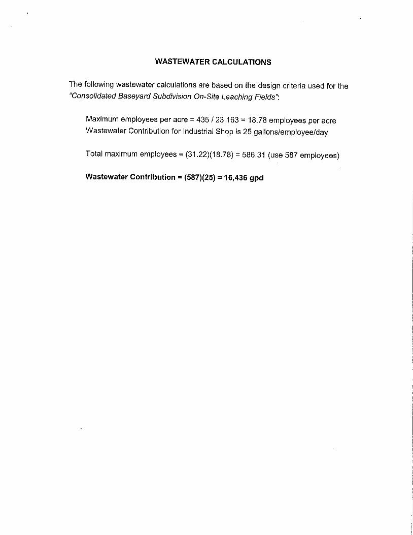
WASTEWATER CALCULATIONS
The following wastewater calculations are based on the design criteria used for the"Consolidated Baseyard Subdivision On-Site Leaching Fields":
Maximum employees per acre = 435 / 23.163 = 18.78 employees per acre
Wastewater Contribution for Industrial Shop is 25 gallons/employee/day
Total maximum employees = (31.22)(18.78) = 586.31 (use 587 employees)
Wastewater Contribution = (587)(25) = 16,436 gpd

EXHIBITS
1 Location Map
2 Vicinity Map
3 Soil Survey Map
4 Flood Insurance Rate Map

o_<ÿ
o
o"I-
v
o
orn
5
LL.0
_.l
co
wo<0
o
Z_oÿ_
C3I©x_.J LLJ

of fo sc#ÿ
0_<r.
\
//
I:T::
\


"!ÿONE AEF
--- PROJECT SITE
t
FLO00 ZONE DEFINITIONSSPECIAL FLOOD HAZARO AREAS SUBJECT TO INUNDATION BY '/HE t% ANNUALCIRCE FLOOD - The ÿ% annual chance flood (lOOqear floOd), also known as the baseIlood, Ls the flood thai has a 1% cÿhanoe oI ÿiro equaled or exceeded ÿ any 9Jven yeaz.The Speoat Flood Hazard =s the ,9ÿea subject Io ÿodinO by the 1% aÿuÿl manc, e floodAreas ot Special Flood Hazard include Zone A, AE. AH, AO, V, and V£, The Base FbodEievabon (BFE) ÿ tAe walet.surfaoa etevalioÿ o( the 1% annual chance (Ioÿ. I,ÿanda(oryflood insurance pÿrchase apÿ,es in these zones,
[] Zone A: No BFE detenrdned.Zone AE: BFE delennined
[] Zone AH: Flood depI.h.s ol 1 lo 3 leer (usualty areas o! rÿding); BFE dei{:rmiÿ,d.Zone AO, Fkw:)d depths of 1 to 3 lee[ (ÿually sheel flow on sloping lerrain),avuage depths detelmined,
[] Zone V: Cÿalat ÿ zone with velodÿi haza,'d (wave .ÿtk)n), no BFE deteÿnod[] Zone ME: Coastal flood zone w=ÿ veÿo,:ib/hataÿd (wave ÿ): BFE deternÿ,'ÿd_[] Zone AEF: Floodway aÿeas in Zone AE. The fi::ÿdway ÿs the channel (:4 sO'earn
plus any adjacenl floodFÿain areas Ihal musl be keÿ hoe ol encÿoachmen! so thaithe 1% annual chance Ik)od can be carried wilhoul increasing the BFE.
NON.SPECIAl, FLOOD HAZARD AREA - Aÿ a(ea =n a k.ÿv-to-modetafe risk ÿ zone.No mandalOr/flood irÿuranoe purchase requiÿemenÿ apply, but COVOh'Kÿe is aVailable inparliopal}ÿ communities.
[] Zone XS (X ÿd)' Areas of 0.2% annual r_ÿnce fk:ÿd, amos o! 1% annualchance flm)d wHh avuage depJhs ol less than I IÿOl oÿ ÿlh drainage areas lessthan 1 square mile, and aÿcas prolected by leveL's [tOm I% annual chaÿw:-e Ikx)d,
Zone X: Aÿeas deletmmÿ Io be outside lhe 0 2'4 annual chan,-.e floodplain
OTHER FI.OOD ARFASZone D: Unsludied areas where flood hazards a(e uedelerm,ncÿ, b,JI flc,ÿd.Opossible. NO manclaloÿy Ibod ÿnsuÿnce puzchaÿe ÿequ¢ÿYnenLÿ app?y, bul covelage/.s ava,lnble in paÿopalm9 communilÿes.
PROPERTY INFORMATIONCOUNTY: l.ÿUlTMK NO' (ÿ 3,ÿ-oo7,10ÿPARCEL ADDRESS: ,ÿ45 E WAIKO RE)£1RM INDEX DATE: SEFIEt49ER 25, ?¢..ÿ9LETTER OF MAP CItANGE(S): NONE
l F(MA FIRM PANEL(S): 1500030393E. SEPT EMBER 25 ÿ009I[X)0030394E-$EPTEMB[R 25 2009
PARCEL DA1A FROM, AUGUST 2010IMAGERY DATA FROM. EÿY 2005
IMPORTANT PHONE NUMBERSC.,o9. nbi NF IP COordma(o(
Counht of MauÿFrÿ',c.ÿ Ce,lzo, CFM (E,08) 210.7711late NFIP ¢oo(d,nalor
Carol Tyau-Ream, P E, CFM (608) 587.0267
FLOOD INSURANCE RATE' MAPEXHIBIT 4

uÿ
1200
W
b ÿ
W
a.o. 0
Exhibit "9"

No. of pages: 1Emai.ÿl: [email protected],com
Tom Nance WaterResource Engineering
Original [] will [] will notbe mailed to you.
October 1, 201212-1951 11-08
MEMORANDUM
To: Vince Bagoyo
From: Tom Nance
Subject: Response to Item 2 of the SLUC's September 26, 2012 Letter
The proposed industrial subdivision will be supplied by two existing wells (identified as State Nos.5129-02 and -03) which are located in and draw from the Kahului Aquifer System. The State Commissionon Water Resource Management (CWRM) has set the sustainable yield of this aquifer at 1.0 milliongallons per day (MGD) based on a conservative calculation of rainfall-recharge on about half the aquifer'stotal area.
In actual fact, the aquifer has been pumped for many decades at 45 MGD and is presentlypumped at between 25 and 30 MGD, all without adverse effects such as increased salinity or water leveldecline. How is this possible? The reality is that the CWRM°s 1.0 MGD sustainable yield amount does
not include the aquifer's most important sources of recharge and unique hydro-geologic characteristics.Beyond its modest direct rainfall recharge, the aquifer's more significant sources of recharge include:groundwater underflow from Haleakala and from the West Maul mountain; surface runoff from both of
these mountains out onto the Kahului isthmus where it sinks into the ground; irrigation return flow fromHC&S sugarcane fields; leakage from HC&S ditch systems; and leakage from Waiale Reservoir whichreceives ditch flow and surface runoff from most of WaUuku Town. With these additional sources of
recharge, salinity intrusion into the aquifer is retarded by thick caprock deposits along the ai:luifer's twodischarge shorelines, Maalaea and Kahului Bays.
The CWRM recognizes that its sustainable yield figure is not realistic and continues to issuepermits for new wells, albeit with a disclaimer that the loss of sugarcane's irrigation return if the plantationcloses may result in higher salinity. That irrigation return flow may be on the order of 25 to 30 MGD as a
first order approximation. However, the plantation's closing would also reduce aquifer pumpage by more
than 25 MGD, leaving current and projected future pumpage at less than five (5) MGD. In a possiblepost-plantation closure future, the two wells supply the proposed industrial subdivision will continue toprovide the necessary quantity and quality of groundwater.
Exhibit "10"560N Nimilztlwy -Suit¢213,1!onolulu. tla\vaii%817.Phone.(8081537-lllt ,Fax:(808)538-7757,1mail:min:dtnwre.cÿml

o
Z
Exhibit "11"

CERTIFICATE OF SERVICE
I hereby certify that due service of the within document was made by depositing
the same with the United States Mail, postage prepaid, or by hand delivery, on October ÿ____ÿ_,
2012, addressed to:
JESSE K. SOUKIDirectorOffice of PlanningState of Hawaii235 South Beretania Street, Room 600Honolulu, Hawai'i 96813
BY MAIL
BRYAN C. YEE, ESQ.Deputy Attorney GeneralDepartment of the Attorney General425 Queen StreetHonolulu, Hawaii 96813
BY MAIL
WILLIAM SPENCEDirector, Planning DepartmentCounty of Maui250 South High StreetWailuku, Hawaii 96793
BY HAND DELIVERY
PLANNING COMMISSIONCounty of Maui250 South High StreetWailuku, Hawaii 96793
BY HAND DELIVERY
PATRICK K. WONG, ESQ.Corporation CounselDepartment of the Corporation CounselCounty of Maui200 South High StreetWailuku, Maui, Hawaii 96793
BY HAND DELIVERY
MAUI ELECTRIC COMPANY, LIMITEDAttention: Dan TakahataP. O. Box 398Kahului, Hawaii 96733-6898
BY MAIL
4845-4063-3105.1.065195-00001

HAWAIIAN TELCOM INC.Attention: Legal DepartmentP. O. Box 2200Honolulu, Hawaii 96816
BY MAIL
FONG CONSTRUCTION COMPANY,LIMITED
405 Hukilike Street, Bay 4Kahului, Hawaii 96732
BY MAIL
NOBRIGA'S RANCH, INC.P. O. Box 1170Wailuku, Hawaii 96793
BY MAIL
DATED: Wailuku, Hawaii, October" .,2012.
B. MARTIN LUNAGREGORY K. SCHLAIS
Attorneys for PetitionerWAIKO INDUSTRIAL INVESTMENT, LLC
4845-4063-3105.1.065195-00001 2.