Embed Size (px)
Citation preview
Grizzly Bear, Woodland Caribou, and Dall’s Sheep
Background Information for the
Dehcho Land Use Plan
John L. Weaver, Ph.D.
WILDLIFE CONSERVATION SOCIETY CANADA
January, 2006
1
Grizzly Bear, Woodland Caribou, and Dall’s Sheep
Background Information for the
Dehcho Land Use Plan
INTRODUCTION
The Dehcho territory covers about 215,000 km2 in the southwest corner of the
Northwest Territories. The Mackenzie River or Dehcho (meaning big river) and its
tributaries are a major feature of the landscape. The Dehcho Land Use Planning
Committee seeks to finalize its Land Use Plan (LUP) by March 2006.
One of the 30 land use zones identified in the Plan is Zone 6: Greater Nahanni
Ecosystem (NahÆâ Dehé), which surrounds Nahanni National Park Reserve. The
boundaries of the park reserve were established quickly in 1972 to protect the spectacular
falls and canyons of the famed South Nahanni River from imminent hydroelectric
development. Consequently, the Park Reserve is less than 10 km wide in some sections
and encompasses only a small portion (14% or 4766 km2) of the South Nahanni River
watershed.
Both the Dehcho First Nation and Parks Canada have a strong interest in providing
for ecological integrity of the Greater Nahanni area. Together, they have articulated the
following vision which embraces traditional ecological knowledge and principles of
conservation biology:
NahÆâ Dehé will protect a wilderness watershed in the Mackenzie Mountains where
natural processes such as fires and floods will remain the dominant forces shaping the
park’s ecosystems. Special features of the park, including waterfalls, hotsprings, glaciers,
plateaux, canyons, karst landscapes and cultural/spiritual sites will be preserved.
Naturally-occurring plant communities will thrive and native animal species, including
woodland caribou and grizzly bears, will be sustained at viable population levels.

2
Through a Memorandum of Understanding, Dehcho First Nations and Parks Canada
have agreed to work together to expand Nahanni National Park Reserve within the
Greater Nahanni Ecosystem. Under the Interim Measures Agreement (IMA) signed in
2003, approximately 85% of the South Nahanni River watershed within the Dehcho
territory (excluding the present Nahanni National Park Reserve) was withdrawn from
issuance of new dispositions for 5 years. The remaining 15% not withdrawn is comprised
of 5 distinct blocks: (1) upper Prairie Creek, (2) upper Caribou River, (3) northwest of
Tungsten, (4) Black Wolf Creek, and (5) upper Clearwater-Flood Creeks. The draft
Dehcho LUP (November 2005) proposes that all of the Greater Nahanni Ecosystem
(South Nahanni River watershed and the adjacent Nahanni Karstlands: 40,000 km2) be
managed as a Conservation Zone (Zone 6) until new boundaries are approved for
Nahanni National Park Reserve.
Wildlife species that use large, ecologically diverse areas can serve as useful
‘umbrellas’ or surrogates for conservation of other species. Specific information about
the occurrence and seasonal ranges of such landscape species can provide important
information for land use planning. The NahÆâ Dehé Consensus Team for Nahanni
identified ‘sahcho’ or grizzly bear (Ursus arctos horribilis), ‘medzih’ or woodland
caribou (Rangifer tarandus caribou), and ‘doo’ or Dall’s sheep (Ovis dalli dalli) as
pertinent species. Selection of this suite was appropriate because the problem of
inadequate boundaries is especially acute for wide-ranging animals such as carnivores
and northern ungulates that occur at low densities, possess lower resiliency to human
impacts, and require large, secure areas to sustain viable populations. Empirical data on
selected species provides a more credible basis for conservation planning than arbitrary
political targets (Svancara et al. 2005).
I began surveys of grizzly bears in the Greater Nahanni area in 2002 and initiated
studies on woodland caribou and Dall’s sheep in 2004. The purpose of this short report is
to provide key findings of these on-going studies to the Dehcho LUP Committee. A final
report will be available in the summer of 2006.

3
GRIZZLY BEAR
Grizzly bears have low resiliency compared to other carnivores (Weaver et al. 1996).
Their need for high-quality foods in spring and fall, their low reproductive rate, and their
conservative dispersal (especially females) does not provide much resiliency in the face
of human activities. Indeed, the drastic decline of grizzly bears throughout much of North
America attests to their vulnerability and need for large, secure areas. The Committee on
the Status of Endangered Wildlife in Canada (COSEWIC) has designated the
northwestern population of grizzly bears as one of ‘special concern’ (COSEWIC 2002a).
Methods
In the late 1990’s, Canadian bear researchers and geneticists pioneered a new
technique for surveying bears using non-invasive, scented stations to collect hair for
DNA analysis (Woods et al. 1999). Such data can provide a rich set of information on the
species, gender, individual identity, and genetic diversity of bears. I followed their basic
protocols in the field (Weaver 2004); Wildlife Genetics International in Nelson, BC,
conducted all DNA analyses (Paetkau 2003). During 3 seasons (2002-2004), my
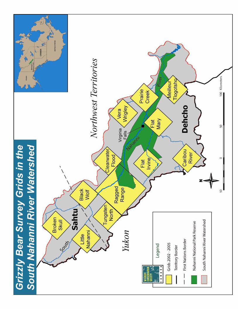
assistants and I established stations at 177 sites across the South Nahanni River (SNR)
watershed (Map 1). We used data on grizzly visits to these stations along with digital data
on terrain features and coarse classification of land cover types to construct a preliminary
model and map of grizzly bear occurrence across the watershed (following Apps et al.
2004). We surveyed another 48 sites in 2005 to verify and refine the model.
Results During the June survey period (2002-2004), grizzly bears occurred at ‘high’ and ‘very
high’ levels of relative abundance in the mountains and tributary valleys of the northern
portion of the SNR watershed (Map 2). Grizzlies were less common in the boreal forests
of the southwest sector of the watershed. Additional collection of hair at natural rub trees
along the South Nahanni River revealed that grizzlies used the main river corridor,
4
primarily above Náîlîcho or Virginia Falls. We collected hair of various individuals
(particularly males) at numerous sites that were 30-50 km apart. These distances suggest
that these bears had home ranges perhaps as large as 2000 km2. In addition, several of the
male grizzly bears detected in the Clearwater-Flood, Tungsten North, and Black Wolf
grids also used the trails around Gahnîhthah or Rabbitkettle Lake inside Nahanni
National Park Reserve. Genetic analyses revealed that Nahanni grizzlies exhibit the
highest level of genetic diversity (along with grizzlies in Kluane) found in grizzly bears
across their North American range (Paetkau et al. 1998, David Paetkau, pers.comm.)
Discussion At present, Nahanni National Park Reserve is too narrow and too small to sustain a
viable population of grizzly bears. The extensive block of boreal forest in the broadest
portion of the South Nahanni River watershed does not support a high density of grizzly
bears. The mountains and tributary valleys of the upper SNR watershed support high to
very high occurrence of grizzlies and contribute importantly toward a viable population
of grizzly bears.
Interim land withdrawals under the IMA did not protect several areas important to
grizzly bear conservation, including upper Prairie Creek and upper Clearwater-Flood
Creeks. Designation of Zone 6: Greater Nahanni Ecosystem as a Conservation Zone in
the Dehcho LUP would protect important habitats for grizzly bears throughout the South
Nahanni River watershed.
WOODLAND CARIBOU
Woodland caribou in the boreal cordillera of western Canada use boreal forests in
winter where they paw through shallow snow to feed on ground lichens. In spring, they
migrate to alpine areas where they calve, spend the summer, rut in the fall, and stay some
time during milder winters. Compared to other species of ungulates, woodland caribou
have low resiliency to impacts on habitats and populations resulting from human
activities (McLoughlin et al. 2003). The northern mountain population of woodland
caribou has been designated as one of ‘special concern’ by the COSEWIC (2002b).

5 Methods
I compiled locations of radio-collared woodland caribou in the SNR watershed from
several sources. In March 1995, 25 adult female caribou were fitted with conventional
(VHF) radio-collars near Virginia Falls; park wardens obtained locations a few times
each year during 1995-1997 (Gullickson and Manseau 2000). From 1998 to 2002, 11
additional female caribou were fitted with satellite (PTT) radio-collars; locations were
obtained every 5 days (A. Gunn and J. Adamczewski, personal communication). In
October 2004, biologists with the Yukon Department of Environment captured 18 adult
female caribou along the Yukon-Northwest Territory border and fitted them with satellite
(PTT) radio-collars that provided locations every 5 days. Finally, the Sahtu Renewable
Resources Board provided locations of caribou fitted with satellite radio-collars that use
the SNR watershed. I thank all the caribou researchers for generous sharing of their data.
Results
I have identified 3 distinct caribou herds that use portions of the South Nahanni River
watershed: (1) Lower SNR herd, (2) Upper SNR herd, and (3) Redstone herd (Map 3).
The Lower SNR herd finds critical winter range inside Nahanni National Park
Reserve below Náîlîcho (Virginia Falls). In May, these caribou migrate quickly 100-
200 km westward to the mountains of southeast Yukon where they calve and spend the
summer. In early October, males and females group together for the rut along the Yukon-
NT border. During milder winters, some caribou winter along the border whereas in
harsh winters, they migrate eastward to lower areas in Nahanni with less snow cover. The
annual home range of this herd is approximately 32,000 km2. Within the range of this
herd, Yukon biologists counted 348 caribou in the LaBiche area in 1993 and 383 caribou
in the upper Coal River area in 1997 (R. Florkiewicz, personal communication). Due to
inclement weather during surveys, these were incomplete counts.
The Upper SNR herd winters along the South Nahanni River above Virginia Falls and
in the Clearwater basin. In May, most of these animals migrate north 150-250 km to the
northwest corner of the SNR watershed. Here, in the alpine areas northwest of Tungsten

6
to beyond Howards Pass, they calve, spend the summer, and rut during October.
Afterwards, they migrate southward following the South Nahanni River or the Flat River.
The annual range of this herd is approximately 16,000 km2. In 2001, biologists counted
781 animals and estimated the population size to be 940-1140 (Gunn et al. 2002).
The Redstone herd occurs mainly north of the South Nahanni River watershed in the
Sahtu region. During May and June, some caribou from this herd have their calves in the
headwaters region of the South Nahanni (Sahtu). During fall and winter, some Redstone
caribou winter within Dehcho territory in the upper basin of the Clearwater and Cathedral
Creeks in the SNR watershed and the upper basins of Thundercloud Creek and the North
Nahanni River.
Discussion
At present, Nahanni National Park Reserve is too narrow and too small to protect
critical seasonal ranges (winter range, calving sites, rutting areas, and migratory routes)
of several herds of woodland caribou. Interim land withdrawals under the IMA did not
protect several areas important to woodland caribou, including alpine areas northwest of
Tungsten, the upper Caribou River basin, and the upper Clearwater-Flood Creek basin.
Within the Dehcho territory, designation of Zone 6: Greater Nahanni Ecosystem as a
Conservation Zone would protect important caribou areas in the SNR watershed.
One of the winter ranges for the Redstone caribou, however, includes not only the
upper Clearwater-Flood Creek basin but also the adjacent basins of Thundercloud Creek
above Coates Lake and the North Nahanni River. Under the draft Dehcho LUP, a 3-km
buffer zone along the North Nahanni River (Zone 18) is designated as a Conservation
Zone. The section of the Thundercloud Basin nearest Coates Lake is designated as a
Special Management Zone (Zone 25) where mining and oil and gas development would
be permitted. The remainder of this wintering area for caribou is designated as a General
Use zone in the draft Dehcho LUP. Recently, the Sahtu have proposed the area
immediately adjacent to the north as a conservation area under the Sahtu LUP.
7
DALL’S SHEEP
Dall’s sheep are habitat specialists that use alpine tundra habitat near cliffs which
provide adequate escape from predators. Moreover, in winter, sheep select sites where
snow accumulation is shallow due to light snowfall or wind. Consequently, Dall’s sheep
occur in discrete ‘islands’ or patches of suitable habitat of varying size. Because suitable
sites represent stable plant communities and enduring terrain features, sheep (particularly
females) tend to stay ‘at home’ and not disperse very far (Geist 1971). Thus, sheep
populations may be structured genetically by groups of related females or ‘matrilines’
occupying distinct, traditional ranges (Ramey 1993). During the Wisconsin glaciation
(70,000 to 10,000 years BP), the Mackenzie Mountains represented the ‘eastern arm’ of
Berengia and served as major refugia between the Laurentide and Cordilleran glaciers
(Loehr et al. 2005).
Methods
Based upon extensive field surveys, Simmons (1982) delineated the distribution of
Dall’s sheep throughout the Mackenzie Mountains. From the 1980s to present, NWT
biologists and Parks Canada wardens periodically have conducted sheep surveys in the
southern portion of the Mackenzie Mountains (Case 1985, Parks Canada 199?). We
observed sheep from air and ground on the Nahanni Plateau, Ram Plateau, and Tlogotsho
Plateau. We collected shed hair and faeces of sheep for possible DNA analysis, too.
Results
Groups of Dall’s sheep occur in suitable patches of alpine habitat scattered
throughout the South Nahanni River watershed (Simmons 1982). Some of the larger
patches of occurrence include the Tlogotsho Plateau, Nahanni Plateau, and Sunblood
Range where winter snow pack is shallow and/or windblown. Recent genetic studies
indicate that sheep throughout much of the Mackenzie Mountains share similar genetic
structure (Worley et al. 2004). The distribution map (Simmons 1982) suggests that the
mountainous divide at the head of Clearwater and Flood Creeks may serve as a
landscape-level linkage for sheep in Nahanni to other sheep bands further north in the
8
Mackenzie Mountains. Dall’s sheep on the Tlogotsho Plateau, however, exhibit a
different genetic structure than sheep elsewhere in the Mackenzies (Worley et al. 2004).
During the course of sheep surveys, we discovered a concentration of caves used by
sheep on the Nahanni Plateau (north of the Ram River) and others on the Ram Plateau.
These karst caves on the Nahanni Plateau occur approximately 15 km to the west of the
known extent of karst features (Derek Ford, personal communication). We documented
22 caves in one small basin (3 km2) and another 13 caves in the adjacent basin. We
observed ewe-lamb pairs inside several of the caves. Sheep in the Nahanni Range further
east also use caves (Case 1989, this study). Results from DNA analyses of the hair and
faeces are pending.
Discussion
Most of the important sheep ranges (i.e., Tlogotsho Plateau, Nahanni Plateau, and
Sunblood Range) lay outside the present boundary of Nahanni National Park Reserve.
Discovery of sheep using the numerous caves on the Nahanni Plateau is notable in
two respects. It extends the known occurrence of the Nahanni karst features which are
considered the finest in the temperate latitudes of the world. Moreover, it represents the
greatest concentration of wild sheep using caves documented anywhere in North America
(personal communications with sheep biologists). The caves offer a moderate
environment and shelter during both summer and winter. Typically, they are located in
places where predators would find access very difficult. At the entrance to the caves,
deep deposition of sheep faeces provides ‘fertilization’ whereas water dripping from the
front edge of the cave roof provides ‘irrigation’. Most of these cave entrances exhibited a
lush growth of grass and forbs that appear as an oasis in a desert of stone. I hypothesize
that this unique combination of cave and lush grass allows ewes with lambs to minimize
risk of predation while having good forage, thereby increasing survivorship of lambs.
Designation of Zone 6: Greater Nahanni Ecosystem as a Conservation Zone in the
Dehcho LUP would protect annual ranges of Dall’s sheep in the South Nahanni River
watershed as well as the continentally-unique occurrence of sheep using caves on the
Nahanni and Ram Plateaus.
9
CONCLUSIONS
The present boundaries of Nahanni National Park Reserve are too narrow and too
small to provide for the seasonal needs and viable populations of grizzly bears, woodland
caribou, and Dall’s sheep. Interim land withdrawals under the IMA did not protect
several areas important to these species, including
• upper Prairie Creek (grizzly bear and Dall’s sheep), • upper Caribou River (woodland caribou), • northwest of Tungsten (woodland caribou), and • upper Clearwater-Flood Creek (grizzly bear, woodland caribou, and Dall’s sheep). Designation of Zone 6: Greater Nahanni Ecosystem as a Conservation Zone in the
Dehcho LUP would protect critical seasonal ranges, contribute substantially to sustaining
viable populations, and safeguard unique phenomena for these important wildlife species.
LITERATURE CITED Apps, C.D., B.N. McLellan, J.G. Woods, and M.F. Proctor. 2004. Estimating grizzly bear
distribution and abundance relative to habitat and human influence. Journal of Wildlife Management 68:138-152.
Case, R. 1989. Distribution and abundance of Dall’s sheep in the southern Mackenzie
Mountains, Northwest Territories. File Report No. 81. Department of Renewable Resources, Government of the Northwest Territories. Yellowknife.
COSEWIC. 2002a. COSEWIC assessment and update status report on the grizzly bear
Ursus arctos in Canada. Committee on the Status of Endangered Wildlife in Canada. Ottawa.
COSEWIC. 2002b. COSEWIC assessment and update status report on the woodland
caribou Rangifer tarandus caribou in Canada. Committee on the Status of Endangered Wildlife in Canada. Ottawa.
Geist, V. 1971. Mountain sheep: a study in behavior and evolution. The University of
Chicago Press, Chicago. Gullickson, D., and M. Manseau. 2000. South Nahanni Woodland Caribou Herd seasonal
range use and demography. Parks Canada Agency.
10 Gunn, A., R. Farnell, J. Adamczewski, J. Dragon, and L. Laberge. 2002. Census for the
South Nahanni Mountain Caribou Herd. Report No. 147. Department of Resources, Wildlife, and Economic Development, Government of Northwest Territories, Yellowknife.
Loehr, J., K. Worley, A. Grapputo, J. Carey, A. Veitch, and D.W. Coltman. 2005.
Evidence for cryptic glacial refugia from North American mountain sheep mitochondrial DNA. Journal of Evolutionary Biology.
McLoughlin, P.D., E. Dzus, B. Wynes, and S. Boutin. 2003. Declines in populations of
woodland caribou. Journal of Wildlife Management 67:755-761. Paetkau, D. 2003. An empirical exploration of data quality in DNA-based population
inventories. Molecular Ecology 12:1375-1387. Paetkau, D., L. Waits, P. Clarkson, L. Craighead, E. Vyse, R. Ward, and C. Strobeck.
1998. Variation in genetic diversity across the range of North American brown bears. Conservation Biology 12:418-429.
Ramey, R.R. II. 1993. Evolutionary genetics and systematics of North American
mountain sheep: implications for conservation. Dissertation, Cornell University, Ithaca.
Simmons, N. 1982. Seasonal distribution of Dall’s sheep in the Mackenzie Mountains,
Northwest Territories. File Report No. 21. Northwest Territories Wildlife Service. Yellowknife.
Svancara, L.K., R. Brannon, J.M. Scott, C.R. Groves, R.F. Noss, and R.L. Pressey. 2005. Policy-driven versus evidence-based conservation: a review of political targets and
biological needs. BioScience 55. Weaver, J.L. 2004. Trans-boundary survey of grizzly bears in Nahanni National Park
Reserve. 2003 Progress Report. Wildlife Conservation Society. Weaver, J.L., P.C. Paquet, and L. F. Ruggiero. 1996. Resilience and conservation of large
carnivores in the Rocky Mountains. Conservation Biology 10:964-976. Woods, J.G., D. Paetkau, D. Lewis, B.N. McLellan, M. Proctor, and C. Strobeck. 1999.
Genetic tagging free ranging black and brown bears. Wildlife Society Bulletin 27:616-627.
Worley, K., C. Strobeck, S. Arthur, J. Carey, H. Schwantje, A. Veitch, and D.W.
Coltman. 2004. Population genetic structure of North American thinhorn sheep (Ovis dalli). Molecular Ecology 13:2545-2556.