Embed Size (px)
Citation preview

© 2011 The MITRE Corporation. All rights reserved
Mr. Craig Bonaceto, Dr. Edith Mooers, Mr. Stephen Theophanis, Dr. Varley Wrick
June 2011
Ground Moving Target Indicator (GMTI) Utility Analysis for Airborne AssetsA mission-based framework for requesting and planning GMTI support

© 2011 The MITRE Corporation. All rights reserved 2
Outline
Introduction to GMTI and Planning Challenges
Mission-Based Approach to GMTI Planning
Moving Target Indicator Interpretability Rating Scale (MTIIRS): Assessing required GMTI data fidelity to support the mission
Decision Support Applications– PRISM Input Tool© (PIT): Requesting GTMI support– GMTI Planning Tool© (GPT): Planning GMTI collections
Mission-Based GMTI Request
MTIIRS Level Sensor Tasking

© 2011 The MITRE Corporation. All rights reserved 3
Introduction – What is GMTI?
GMTI = Ground Moving Target Indicator– An INT type that detects and tracks
moving surface objects in an area of interest
– Detections can be associated to form tracks, or used for situational awareness
– Traditionally radar-based, but can be from other sources such as video and SIGINT
Typical uses of GMTI– Discover and characterize lines of
communication– Monitor borders– Track high value targets

© 2011 The MITRE Corporation. All rights reserved 4
GMTI Planning Challenges
GMTI data collection is complex and multi-dimensional, involving detection across time and space
GMTI planning today is based on implicit assumptions about the effectiveness of GMTI sensing strategies in meeting operational objectives.
Collaboration and planning suffers from inconsistencies in these assumptions between humans and machines, as well as between humans in different echelons, locations, and organizations. [Hence lots of chat.]
Standardized mission types and model-driven mission planning tools are needed to provide potential sensing strategies spanning multiple GMTI sensors/platforms that satisfy end-user operational objectives.

© 2011 The MITRE Corporation. All rights reserved 5
Mission-Based GMTI Planning Process
GMTI PlannersGMTI Requesters
“I need a JSTARS with a 10second revisit rate.” Lacktools to structure requests inmission-centric terms.
“Hands tied” to requested revisitrates. Requests often lack neededinformation.Lack systems to evaluate missionsatisfaction and plan multi-platformcollects.
Mission: “I need to identify traffic patterns along a road.”
Provide decision support tools toevaluate tasking requirements and planGMTI collections based on missionneeds and area characteristics.
PRISM Input Tool© GMTI Planning Tool©
CurrentProcess
ImprovedProcess Mission-Based
GMTI Request MTIIRS Level

© 2011 The MITRE Corporation. All rights reserved 6
GMTI Mission Types and Essential Elements of Information (EEIs)
Mission Types:– Track high value targets – Monitor a border, facility, or other area of interest– Perform force protection or convoy over-watch– Maintain situation awareness in a region– Identify patterns of activity in a region
EEIs– Characterize baseline movement– Establish traffic patterns– Identify activity on established routes– Identify activity on non-traditional routes– Perform incident backtracking (forensics)– Identify enemy reactions to friendly actions– Identify milling activity
© 2011 The MITRE Corporation. All rights reserved 7
The Moving Target Indicator Interpretability Rating Scale (MTIIRS)
Previous efforts to define GMTI fidelity based on the analogy to imagery: National Imagery Intelligence Interpretability Rating Scale (NIIRS)- Imperfect analogy: GMTI data is not imagery- GMTI data fidelity is the degree to which targets are
unambiguously distinguished Current approach: “GMTI Units” based on area scanned per
hour is insufficient as it does not consider update rate MTIIRS Approach:
– Characterize required GMTI data fidelity given mission requirements
– Enable collection planners to bin requests by difficulty
– Characterize fidelity of previously collected GMTI data
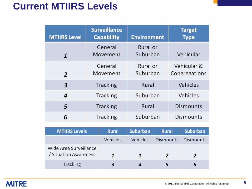
MTIIRS is currently is linear scale comprised of 6 levels in increasing order of fidelity
MTIIRS levels are derived from the triad of mission type, target types of interest, and area characteristics
© 2011 The MITRE Corporation. All rights reserved 8
Current MTIIRS Levels

© 2011 The MITRE Corporation. All rights reserved 9
PRISM Input Tool©Structuring GMTI Requests
Goal: Develop a software tool to:– Assist in requesting GMTI support in mission-centric terms
Old Way: “I need a JSTARS with a 30 second revisit rate” New Way: “I need to identify traffic patterns along a road”
– Add structure to the GMTI request process– Be “Turbo Tax” easy-to-use– Compute an MTIIRS level based on request– Export requests as formatted text and XML to PRISM
Needs Addressed: – GMTI requests are currently poorly structured and not reproducible– GMTI is not a well understood INT type by end-users– Structuring requests will:
Standardize the process and avoid confusion Help requesters understand GMTI a Help planners better manage and utilize GMTI assets
© 2011 The MITRE Corporation. All rights reserved 10
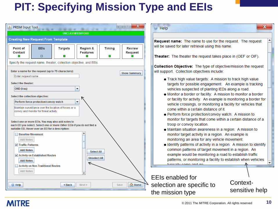
PIT: Specifying Mission Type and EEIs
EEIs enabled for selection are specific to the mission type
Context-sensitive help

© 2011 The MITRE Corporation. All rights reserved 11
MTIIRS Calculation

© 2011 The MITRE Corporation. All rights reserved 12
PIT: Request Summary
“Save” when inputs are complete
“Export” provides a text file thatcan be copied to PRISM
Formatted summary paragraph of request

© 2011 The MITRE Corporation. All rights reserved 13
GMTI Planning Tool©GMTI Platform Planning and Optimization
Goal: Develop a decision support capability to:– Provide a structure to allow a non-expert to determine radar tasking
requirements based on mission needs, target type and area conditions
– Evaluate which and how many GMTI platforms are required to satisfy requests
– Determine placement and orbit of platforms to maximize collection effectiveness
– Predict and visualize performance based on platform placement and orbits
Needs Addressed:– Current systems for tasking GMTI collections do not provide
adequate feed back as to whether they satisfy mission needs– No systems exist to plan multi-platform GMTI missions– Improve GMTI platform utilization (reduce/eliminate incorrect
tasking)

© 2011 The MITRE Corporation. All rights reserved 14
GPT: Overall Tool Layout
The platforms browser enables
planners to add, edit, and remove GMTI
platforms.
The collections browser allows
planners to add, edit, and remove GMTI collections.
The analysis area contains an interactive assignment matrix that shows the expected performance of each
platform against each collection.
The interactive map shows areas requiring GMTI coverage.

© 2011 The MITRE Corporation. All rights reserved 15
Summary and Future Directions
Our aim is to standardize the process of requesting GMTI support and tasking GMTI platforms with a mission-based framework
We demonstrated a framework for requesting support based on mission needs, a new MTIIRS metric to assess required fidelity, and a planning tool to relate requests to platform tasking
We intend to next investigate extending this methodology by understanding how GMTI can be combined with other INT types
We also intend to validate our utility models using theater GMTI data collects
Mission-Based GMTI Request
MTIIRS Level Sensor Tasking