Embed Size (px)
Citation preview
Ground-Water Elevations and Flow Directions
Ground water flows from areas of high hydraulic head (high water-level elevation) to areas of low head (low water-level elevation). Because hydraulic heads vary laterally and vertically in a ground-water system, ground-water movement will generally have a vertical as well as a horizontal compo-nent. Contour maps of heads in aquifers are constructed to determine the horizontal direction of flow. The vertical com-ponent of flow can be determined by comparing water levels in nearby wells completed at different depths in the same aquifer or in different aquifers.
A contour map of the water table represents the elevation of the top of the saturated part of the uppermost unconfined aquifer. The horizontal direction of ground-water flow is gen-erally perpendicular to the contour lines and water flows down the slope of the contours in a manner analogous to the flow of water down the slope of the land surface. An accurate map of the water table is constructed from water levels measured in wells that are open to a small interval at the water table. In practice, water-table maps are constructed from water levels measured in wells open over a range of intervals at or below the water table that represent a mixture of heads that are close to, but not at, the elevation of the water-table surface.
If a well is completed in an aquifer confined by overlying materials of low permeability, ground water in the aquifer may be under sufficient pressure to cause the water level in the well to rise above the top of the aquifer. A contour map of heads in a confined aquifer defines a water-level surface that shows the horizontal direction of flow in the confined aquifer. Because hydraulic heads can vary with depth, water-level maps based on measurements from wells completed at different depths or completed in different confined aquifers will reflect some mixture of horizontal and vertical gradients.
Horizontal Ground-Water Flow
Two water-level contour maps were constructed to determine horizontal ground-water flow directions in the Wil-lamette Basin: a water-table map for the basin-fill sediments, and a generalized water-level map for the Columbia River basalt unit. Because water levels vary over time, the maps were largely constructed using measurements from more than 400 wells made during a 2-week period in mid-November 1996, a time of year during which ground-water levels gener-ally approximated average annual water levels. Water levels in many wells were measured prior to heavy rains that fell during the second week of the measurement period. Water levels in most areas rose less than 10 ft in response to the rain event. Therefore, water-level maps based on these measurements are considered to be representative of average annual conditions. Water-level contours were not constructed for most of the Portland Basin because few wells were measured and detailed water-level maps are available in a previous study (McFarland and Morgan, 1996).
Shallow Basin-Fill SedimentsA water-table map for the basin-fill sediments (pl. 1) was
constructed using water levels measured in shallow wells, typically less than 150 ft deep, open to the Willamette silt and upper, middle, and lower sedimentary units. Contours were also constrained by water levels from other shallow wells if measurements were made during late October through early December in any year from 1986 to 2000, and if long-term observation wells in an area showed consistent water levels over that same time interval. Stream-stage elevations were used to determine where water-level contours crossed streams.
Where water-level information was not available, the water-table elevation was estimated relative to land surface. The water table is found within 5 to 20 ft of the land surface in the upper sedimentary and Willamette silt units in most areas of the central and southern Willamette Basin, and in the lower sedimentary unit in the Tualatin Basin based on monitoring wells for water-quality assessments and wells measured as part of this study. Because few measured wells are open to the Wil-lamette silt unit, water-table elevations in this unit were esti-mated using water levels from shallow wells completed in the underlying sedimentary units. The water table will be higher
�0 Ground-Water Hydrology of the Willamette Basin, Oregon
than water levels measured in these shallow wells because, according to drillers’ reports and well data, hydraulic heads decrease with depth in the lowland. In the southern Willamette Basin, where the Willamette silt unit is generally less than 20 ft thick, average annual water levels in shallow wells com-pleted in the underlying middle sedimentary unit are generally within 10 ft of land surface, which closely approximates the water table in the silt. In the central Willamette Basin, where the silt unit is up to 120 ft thick, water levels in the silt can be 10 to 25 ft higher than those in shallow wells completed in the underlying sediments (Iverson, 2002). This difference is con-sistent with the low vertical permeability of the Willamette silt unit, which provides a resistance to vertical flow that results in high water-table elevations relative to water levels in underly-ing units. Consequently, where the silt is thick, water levels in shallow wells completed in underlying sedimentary units will underestimate the elevation of the water table, but errors will generally be less than 25 ft.
Although Piper (1942) recognized that the water table occurred in the Willamette Silt in the central Willamette Basin, he described shallow ground water in the silt as “semi-perched,” which suggests that an unsaturated zone occurs below the water table. However, piezometer and monitoring well data from ground-water quality assessments indicate that the regional water table generally occurs at shallow depths in the silt and that all sediments are fully saturated below this surface.
The regional pattern of ground-water flow is from the margins of the lowland towards the major streams (pl. 1). Ground-water discharge to streams is indicated where contours bend upstream. The change in hydraulic head per unit horizon-tal distance, referred to as the horizontal hydraulic gradient, is represented by the slope of the water table. Closely spaced contours of equal interval indicate a steep hydraulic gradi-ent (steep slope), whereas widely-spaced contours indicate a flat hydraulic gradient. The velocity of ground-water flow is proportional to the hydraulic gradient if the hydraulic conduc-tivity and effective porosity are constant.
In the southern Willamette Basin, shallow ground water flows from the southeast to the northwest in much of the basin and from east to west in the Stayton Basin. Hydraulic gradi-ents are relatively flat, generally less than 15 ft/mi (feet per mile), because of the gently sloping land surface and relatively high permeability of the upper and middle sedimentary units near land surface. Contours are generally perpendicular to streams, indicating that most ground-water flow is nearly par-allel to streams. Although ground water discharges to streams throughout the southern basin, focused ground-water discharge is expected where the Willamette River is constricted to a nar-row trench cut into low permeability materials of the basement confining unit near Albany. This is consistent with water-table contours in the 12-mile reach between the Marys River and the gap at Albany, where the contours bend upstream and are nearly parallel to the Willamette River, indicating flow toward, and discharge to, the river. Focused ground-water discharge is
expected in a similar gap at the confluence of the North and South Santiam Rivers.
Chlorofluorocarbon (CFC) age dates of shallow ground water (Appendix B) are consistent with flow directions indi-cated by the water-table contours in the southern Willamette Basin. Samples were collected from shallow wells in the upper and middle sedimentary units along a flow path from the east edge of the valley floor to the floodplain of the Willamette River near Corvallis (fig. B1). Young water (25 years old or less) was found at the eastern edge of the lowland where local recharge is the principal source of inflow to the shallow ground-water system. Older ground water was generally found to the west, consistent with longer flow paths although ages were variable (16 to more than 57 years old) suggesting mix-ing with younger water. This is to be expected since recharge from precipitation occurs throughout the valley floor. Young ground water (26 years old), found in the upper sedimentary unit at the end of the flow path, may represent the influx of precipitation and surface water into the highly permeable floodplain deposits adjacent to the Willamette River.
Shallow ground-water flow patterns are more complex in the central Willamette Basin because small streams incised up to 50 ft into the Willamette silt unit have a greater effect on shallow water levels than the less incised streams in the south-ern basin. Most small streams in the central basin, such as the Pudding River and Champoeg Creek, occupy deep, narrow, linear trenches cut into the Willamette silt unit. These stream trenches are separated by relatively flat surfaces that form the typical valley floor at the top of the Willamette silt unit. In general, the trenches do not fully penetrate the silt except near their confluence with the Willamette or Mollala Rivers.
In the areas between streams, the water table generally occurs at depths of less than 15 ft within the silt, and hydrau-lic gradients are typically between 20 to 40 ft/mi. Gradients steepen adjacent to the steep cutbanks that form the walls of entrenched stream drainages (Iverson, 2002) and near the steep-walled erosional margins of the unit adjacent to the Willamette River floodplain as the water table drops to the level of the streams. The steep hydraulic gradients adjacent to most small streams in the central basin are probably 500 ft/mi within 200 ft of the stream, which is not depicted on the water-table map in plate 1.
The configuration of the water table in the central Wil-lamette Basin produces a number of local flow systems in the Willamette silt unit in which ground water flows from local topographic highs between stream drainages towards adjacent streams. This pattern indicates local recharge in the silts, a component of horizontal flow within the silts towards local streams, and discharge to local streams. Discharge to these smaller streams is limited by the low permeability of the silt. Because there is little resistance to flow in the more permeable sediments of the upper sedimentary unit, hydraulic gradients are relatively flat in the floodplain of the Willamette River, typically less than 2 ft/mi.
In the basin-fill sediments in the Tualatin Basin, the water table generally occurs at depths of less than 20 ft. Ground
�1Ground-Water Elevations and Flow Directions �1

water flows from the margins of the Tualatin Basin to the center of the basin, where it discharges to streams. Hydraulic gradients are steep because the water table is in the lower sedi-mentary unit, which has low permeability. Although regional discharge is to the Tualatin River, contours indicate a compo-nent of local discharge to tributaries of the Tualatin River.
The elevation and direction of flow indicated by the water table in the sediments of the central and southern Willamette Basins has not changed appreciably since it was first mapped in 1935 (Piper, 1942). This indicates that average annual water levels have generally remained constant in this area since 1935 in spite of the large increase in annual ground-water pump-age over that same span of time. Graphs showing a general absence of long-term decline of water levels discussed in the next section further illustrate this point. Near Woodburn, long-term graphs of water levels indicate a possible decline of less than 10 ft in the water table.
Deep Basin-Fill Sediments—Central Willamette Basin
In the central Willamette Basin, where the Willamette silt unit is thick and confines the underlying permeable deposits of upper sedimentary unit, water levels in the middle sedimentary and lower sedimentary units differ from those of the water table. The change in water levels with depth is gradual, that is, water levels in the upper part of the upper sedimentary unit are similar to the water table, and water levels in the lower part of the upper sedimentary unit and upper part of the lower sedi-mentary unit represent the water levels of a confined aquifer. Ground water in the confined basin-fill aquifer in the central Willamette Basin likely flows to the Willamette River and the lower reaches of the Pudding and Molalla Rivers, where the confining Willamette silt unit has been removed by stream incision. Because few wells are selectively open to the lower part of the upper sedimentary unit, a water-level map of the confined basin-fill aquifer is not available.
The aquifer consisting of the middle sedimentary unit is confined by the Willamette silt unit and has a poor connection to smaller streams. This pattern of flow was recognized by Piper (1942, p. 35) who described the deeper confined unit as “deep pervious beds that pass below the floors of the stream trenches.” Aquifer tests and the response of water levels to precipitation and pumping also suggest that the middle sedimentary unit is confined where the Willamette silt unit is present. Although other studies (Price, 1967a; Woodward and others, 1998) suggest that ground water in the middle sedi-mentary unit in the central Willamette Basin is unconfined and discharges to small streams underlain by Willamette silt unit, hydrologic data collected during this study indicate ground water in the middle sedimentary unit in this area is generally confined and discharges to the Willamette River.
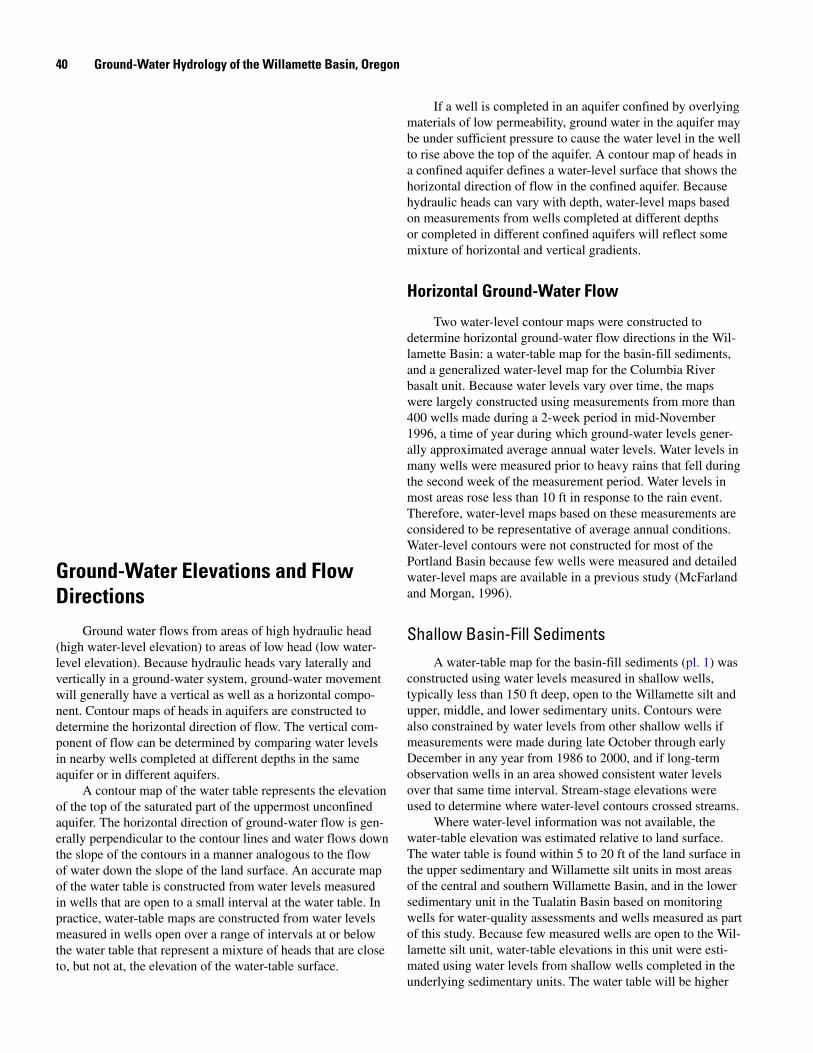
Columbia River Basalt UnitWater-level data in the Columbia River basalt unit were
collected in the Portland, Tualatin, and central Willamette Basins. Constructing a map of water levels in the Columbia River basalt unit presents several problems: (1) measured water levels in the Columbia River basalt unit are not evenly distributed, with many wells open to Columbia River basalt unit at the margins of the basins and relatively few wells in the center of the basin, (2) multiple permeable interflow zones separated by the less permeable flow interiors result in poten-tially large variations in water levels with depth, and (3) water levels in many wells represent composite heads because the wells have uncased boreholes that are open to multiple perme-able interflow zones. Therefore, although water-level maps based on composite heads in the basalts must be interpreted with some caution, some general conclusions about ground-water flow in the basalt unit can be made based on the water-level map shown in figure 19.
The water-level map for the Columbia River basalt unit indicates that ground water in the basalt unit generally moves from upland areas at the basin margins, where the unit is exposed at land surface, towards the basin interiors, where the unit is buried by sediments. The general contour patterns suggest that regional discharge from the unit is to the Tualatin and Willamette Rivers. However, the rate of regional discharge to these streams from the basalt unit is probably low because of the low vertical permeability of the basalts and the great thickness of fine-grained sediments above the basalts (fig. 8). Stream-seepage data (Appendix C) and the occurrence of springs indicate that some ground water in the basalt unit dis-charges to small streams, such as Drift Creek, that are incised into the basalt unit in upland outcrop areas.
Although the direction of ground-water flow inferred from the contours is reasonable, the close spacing of water-level contours where the unit crops out in upland hills sug-gest unrealistically high horizontal hydraulic gradients. The contours are based on wells completed at different depths and open to different permeable interflow zones. These unrealisti-cally steep gradients reflect vertical gradients between perme-able interflow zones rather than horizontal gradients within an interflow zone or within the basalt unit as a whole. Based on water levels in a small number of wells open to similar basalt interflow zones in the Parrett Mountain (Miller and others, 1994) and Silverton (Marc Norton, OWRD, oral commun., 2004) areas, horizontal gradients in the upland areas are expected to be low, less than 10 ft/mi.
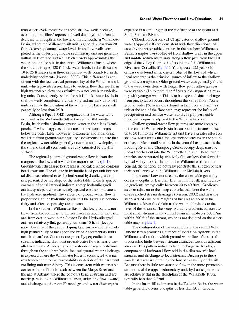
Horizontal gradients beneath the valley floors in the central Willamette Basin near Wilsonville are less than 6 ft/mi based on water-level differences of less than 25 ft in wells that are more than 4 mi apart (fig. 20). Gradients between these wells have decreased by about 50 percent since the City of Wilsonville stopped pumping from the basalt aquifers in late April 2002. This suggests that a significant fraction of the horizontal gradient in the basalts in this area was induced by withdrawals from the City’s wells completed in the basalt unit.
�2 Ground-Water Hydrology of the Willamette Basin, Oregon
44°45'
45°00'
45°15'
45°30'
45°45'
122°45' 122°30' 122°15' 122°00'123°00'123°15'
Tigard.
.Keizer
.Monmouth
.Woodburn
.Newberg
.OregonCity
MountAngel.
.Wilsonville
.SaintPaul
. Aurora
. Milwaukie
. Troutdale.Fairview
.Damascus
.Sherwood
.Tualatin
.Beaverton
.NorthPlains
.
.Dayton
.Lafayette
.ScottsMills
.Dundee
.Amity
.Silverton
.Boring
.Gervais
.Donald
.Stayton
.Hillsboro
.Sublimity
.LakeOswego
Banks
River
North
SouthSantiam
North
SantiamRiver
Littl
e
Pud
ding
Pud
ding
Riv
er
Sout
h
River
River
Clackamas
Bull
RunRiver
River
River
Molalla
Sandy
River
River
Tualatin
Yamhill
CO
LUM
BIA
RIVER
WIL
LAM
ETTE
RIVE
RYamhill
River
R
LuckiamuteDetroitLake
HenryHaggLake Bull Run
Reservoir No. 2
Bull RunReservoir No. 1
M U L T N O M A H
COLUMBIA
WA S H I N G T O N
C L A C K A M A S
P O L K
L I N N
M A R I O N
YA M H I L L
Portland
Salem
.
. .. .
.. .
.
..
.
..
...
.
.
..
...
.
......
..
...
..
...
... .
..
.
...
...
.....
... .
.
.
.
............................
.
.
.
.
.....
.....
. .
..
.. .. ..........
.... ... .
..
.. ...
...
..
.... ..
... .. ......
..
.
.
100
200
200
300
400
500
400
400
200
200
30010
0
1000
200
100
200500
300300
100
200
500
400
300
500
600
500300
400
500
500
Extent of Columbia River basalt unitWater-level contour—Contour interval, in feet, is variable. Dashed where approximately located.General direction of ground-water flow in the Columbia River basalt unitWell with water levels in the Columbia River basalt unit—Measured at least one time between October and December 1996
Scale 1:650,000
5,000 0 10,000 20,000 30,000 METERS
5 0 5 10 15 20 MILES
EXPLANATION
.200
Area ofthis map
WillametteBasin
OREGON
Gales Creek -
Mt Angel
structural zone
Portland Hills - Clackamas River
structural zone
Figure 1�. Generalized lines of equal hydraulic head and ground-water flow direction in the Columbia River basalt unit, November 1996, northern Willamette Basin, Oregon.
Ground-Water Elevations and Flow Directions ��
These observations indicate that horizontal gradients in the basalt unit were probably no greater than 1 ft/mi under natural conditions. Vertical gradients in the basalt unit appear to be low on the valley floor and most ground-water flow in the unit is essentially horizontal in this part of the system.
Water-level fluctuations and elevations in the deeper zones of the Columbia River basalt unit beneath upland areas are similar to fluctuations and elevations in the basalt unit in the basin. For example, the seasonal fluctuations and long-term decline in water levels in a deep upland well (07S/01W-02CAA01) are similar to those in a well open to the basalt unit in the basin lowland (06S/01W-21CDC02) (pl. 1). Water-level
elevations in the two wells differ by less than 15 ft. This similarity suggests a direct connection between deep interflow zones in the uplands and the basin flow system beneath the valley floor.
Various studies suggest that faults can impede horizontal ground-water flow in the Columbia River basalt unit (New-comb, 1959; Bauer and Hansen, 2000; Reidel and others, 2002) by juxtaposing the thinner, permeable interflow zones against thicker, low-permeable flow interiors or by the forma-tion of a low permeability gouge zones along the fault. It is unclear whether faulting in the Columbia River basalt unit affects horizontal flow on a regional scale in the Willamette Basin. Observations from an aquifer test near Mount Angel indicate that the Gales Creek-Mount Angel structural zone acts as a local flow barrier over short time intervals. Conversely, the regional response of water levels in wells near Wilsonville to changes in pumping suggests that faults, which are likely over this large area, may not act as flow barriers. If faults create barriers to horizontal flow in the basalt unit, they will probably have a large impact on the dynamics of ground-water flow when the unit is stressed by pumping since the propaga-tion of pumping impacts will be limited across these boundar-ies.
Vertical Ground-Water Flow
Vertical flow in the ground-water system of the Wil-lamette Basin shows a pattern that is generally downward, consistent with recharge areas. Upward flow components are generally limited to narrow zones adjacent to the major stream drainages, indicating ground-water discharge to streams.
The general pattern of downward flow in the basin can be evaluated by comparing water levels in pairs of adjacent wells completed at different depths (fig. 21, table 7). Downward flow, indicated by negative hydraulic gradients, occurs within the basin-fill sediment, between the basin-fill sediments and the Columbia River basalt unit, and within the Columbia River basalt unit in the lowlands.
Within the basin-fill sediments, a downward component of flow is common, with the largest downward gradient, -2.3 ft/ft, found between the less permeable Willamette silt unit and the middle sedimentary unit. An upward component of flow occurs in the narrow drainages of small streams that are deeply entrenched into the Willamette Silt. Upward components of flow in these areas are consistent with flowing wells that are limited to narrow zones coincident with these drainages. How-ever, ground-water discharge to these streams is limited by the low hydraulic conductivity of the Willamette silt unit. Upward ground-water flow also occurs in the basin-fill sediments near the Willamette River, which is a regional discharge area, and where ground-water discharge occurs through the permeable upper sedimentary unit.
The vertical component of ground-water flow between the basin-fill sediments and the Columbia River basalt unit is downward throughout most of the extent of the basalt unit in
Pud
ding
Riv
erWILLAMETTE
RIV
ER
5 KILOMETERS
5 MILES0
0
5
5
Mol
alla
Riv
er
205
Wilsonville
Sherwood
Aurora
Canby
Donald
16DDD
17ACA15CAC
11ADA01
15BDD
Well with water level affected by Wilsonville municipal pumping
Well pumped by the City of Wilsonville
EXPLANATION15BDD
06ADD
122°37’30”122°52’30”
45°15'
45°22'30”
T 2 S
T 4 S
T 3 S
R 1 W
R 1 E
BasinWillamette
OREGON
Area of this map
See table of contents for mapping sources
60
50
70
80
90
100
110
120
1996 1998 2000 20021997 1999 2001 2003
WAT
ER L
EVEL
ELE
VATI
ON, I
N F
EET
City of Wilsonville converts from ground water to surface water, 4/29/2002
03S/01W-15CAC03S/01E-16DDD04S/01W-06ADD04S/01W-15BDD04S/01W-11ADA0103S/01E-17ACA
Figure 20. Water levels in wells open to the Columbia River basalt unit near Wilsonville, Oregon, 1996–2003.
�� Ground-Water Hydrology of the Willamette Basin, Oregon

ginddu
P
N Fk
M Fk etteWillam River
Moh
awk
Marys
Middle
Santiam
NorthSantiam River
Littl
e
Pud
ding
Riv
er
South
River
North
River
Clackamas
BullRun River
River
Molalla
Calapooia
River
River
River
Sandy
River
River
River
River
eMcKenzi
River
tte
Willame
Riv
er
Coa
stFo
rk
Tualatin
River
South
River
Yamhill
ette
Will
am
IAC
OLU
MB
RRIVE
TE
AM
ET
WIL
L
RRI
VE
Yamhill
River
Long
Tom
R
iver
Luckiamute
Waldo Lake
HillsCreek Lake
Lookout Point Lake
Fall Creek Lake
Dorena Lake
Cottage Grove Lake
BlueRiverLake
CougarirReservo
Foster Lake
Green Peter Lake
Detroit Lake
Timothy Lake
HenryHagg Lake
Fern Ridge Lake
unBull R ir No. 1 Reservo
unBull R ir No. 2 Reservo
BullRunLake H M A OT N LM U
MBIACOLU
ONINGTWASH
S M A AC K AC L
K LP O
ONBENT
NNIL
O N I RM A
E NL A
LASDOUG
L LH I MY A
LASDOUG
EG
NA
RT
SA
OC
EG
NA
RE
DA
CS
AC
Basinboundary
44°
45°
122°
123°
20 MILES
10
10
20 KILOMETERS
0
0
mati
naS
orkFeld
idM
R
See table of contents for basemap information
SalemDallas
Eugene
ndPortla
Keizer
Corvallis
Harrisburg
Springfield
Monmouth
Woodburn
Newberg
Oregon City
MountAngel
Wilsonville
SaintPaul
Aurora
Albany
Milwaukie
Troutdale Fairview
DamascusSherwood
Tigard
Tualatin
Beaverton
NorthPlains
Banks
DaytonLafayette
ScottsMills
Monroe
Brownsville Halsey
Veneta
Dundee
Amity
Silverton
Boring
Gervais
Donald
Stayton
Hillsboro
Sublimity
Lake Oswego
BCU
CRB
LSU
MSU
USU
HCU
WSU
EXPLANATION
Hydrogeologic unit High Cascade unit
Upper sedimentary unit
Willamette silt unit
Middle sedimentary unit
Lower sedimentary unit
Columbia River basalt unit
Basement confining unit
Well pair where vertical gradient was measured—Point on symbol indicates direction of gradient. Number shows the gradient in feet per foot. Number less than zero indicates a downward gradient. Color of symbol shows the unit(s) where gradient was measured.
Within basin-fill sediments
Between basin-fill sediments and Columbia River basalt unit
Within Columbia River basalt unit
-0.41-0.09
-0.08
-0.02
-0.08
0.05-0.01
-1.44
0.56
-0.05-0.18
0.26-2.3
-0.07-1.75 -0.1
-0.32
-0.2
-0.38
0.480.48
-0.15 -0.11
-0.45
Figure 21. Vertical hydraulic gradients measured in well pairs, Willamette Basin, Oregon.
Ground-Water Elevations and Flow Directions �5
Table �. Average vertical hydraulic gradient within and between hydrogeologic units of the Willamette Basin, Oregon, determined by water levels in well pairs.
[OWRD, Oregon Water Resource Department; USGS, U. S. Geological Survey; ft, feet]
Location OWRD number USGS site number
Elevation of mid-point of opening (ft above or be-low (-) NGVD2�)
Horizontal distance between
wells (ft)
Average vertical hydraulic gradient
(ft/ft)
Basin Fill (downward)
01S/01E-24BBC01 MULT 63238 452827122382401 30.5
01S/01E-24BBC02 MULT 63239 452827122382402 -33 10 -0.08
01S/02E-13CDA1 None 452840122302202 227.75
01S/02E-13CDA2 None 452840122302201 190.8 3 -0.41
01S/02E-16BAA01 MULT 63388 452921122340401 144
01S/02E-16BDA01 MULT 50871 452912122340401 -155 700 -0.09
05S/02W-08CCA2 MARI 52504 450851122575801 57.5
05S/02W-08CCB1 MARI 52597 450851122580101 -39.5 1,800 -0.18
06S/01W-08DAD06 MARI 55017 450340122493404 119.95
06S/01W-08DAD03 MARI 54952 450340122493402 94.2 3 -0.45
06S/01W-08DAD04 MARI 54953 450339122492801 113.5
06S/01W-08DAD05 MARI 55015 450339122492802 100.7 3 -2.30
17S/02W-30CAA2 LANE 10762 440341122584002 428.5
17S/02W-30CAA1 LANE 10761 440341122584001 340.5 10 -0.11
17S/05W-02BAC2 LANE 3203 440735123154601 365
17S/05W-02BAC1 LANE 12676 440736123154701 276 160 -0.15
Basin Fill (upward)
04S/02W-01CDD02 None 451444122524601 71.15
04S/02W-01CDD01 None 451444122524701 62.45 3 0.56
05S/01W-28CCD01 None 450603122491601 112.25
05S/01W-28CCD02 None 450603122491602 97.35 3 0.26
11S/05W-35DDD LINN 10841 443349123150501 183.23
12S/05W-02AAA LINN 12120 443348123150201 161.29 300 0.48
�6 Ground-Water Hydrology of the Willamette Basin, Oregon

Location OWRD number USGS site number
Elevation of mid-point of opening (ft above or be-low (-) NGVD2�)
Horizontal distance between
wells (ft)
Average vertical hydraulic gradient
(ft/ft)
Basin Fill/CRB (downward)
01N/02W-17ACC WASH 5382 453417122572901 125
01N/02W-17DAB WASH 5377 453414122571001 -501.5 1,000 -0.08
02S/01E-20CBD2 CLAC 3165 452249122430901 73.5
02S/01E-20CBD1 CLAC 12346 452249122430801 -110 60 -0.01
04S/01W-19ACD01 MARI 54896 451235122510401 55
04S/01W-19ACA01 MARI 56530 451237122510601 -411.5 300 -0.05
06S/01W-21CDC01 MARI 3280 450140122490701 -1
06S/01W-21CDC02 MARI 51006 450141122490601 -289.5 100 -0.07
07S/02W-28ADD MARI 7883 445606122554101 127.5
07S/02W-28ADD01 MARI 55258 445604122554501 -54 300 -0.10
08S/01W-30DDB1 MARI 8999 445032122505001 353
08S/01W-30DDB2 MARI 8971 445033122505101 242 140 -0.20
09S/01W-15DCB01 LINN 50629 444704122473001 344
09S/01W-15DCB03 LINN 51763 444704122472801 145.5 160 -0.38
CRB/CRB (downward)
01N/02W-03AAD01 WASH 5090 453613122542901 216
01N/02W-03ABA WASH 14 453618122544701 10 1,350 -0.02
02S/02W-34ADB WASH 13210 452119122544001 683
02S/02W-34ACD WASH 3443 452118122545001 511.5 600 -1.44
07S/03W-18BAD01 POLK 1781 445804123061201 330.5
07S/03W-18AB1 POLK 841 445808123055601 133 1,400 -1.75
08S/02W-13BAD01 MARI 10176 445244122523701 371.5
08S/02W-12CDB01 MARI 9917 445306122524501 302 2,200 -0.32
CRB/CRB (upward)
02S/01W-04ACC WASH 11449 452534122485101 87.5
02S/01W-04BAD WASH 11436 452551122485801 -264 1,600 0.05
Table �. Average vertical hydraulic gradient within and between hydrogeologic units of the Willamette Basin, Oregon, determined by water levels in well pairs—Continued.
[OWRD, Oregon Water Resource Department; USGS, U. S. Geological Survey; ft, feet]
��

the Willamette Basin. This relation can be seen by compar-ing the head maps for the sediments (pl. 1) and the basalt unit (fig. 19) and by comparing adjacent pairs of wells completed in the two units (fig. 21, table 7). Upward components of flow between these units are probably limited to narrow zones in the lower elevation portions of the floodplains of the Wil-lamette, Clackamas, Tualatin, and Columbia Rivers. Flowing basalt wells in the Tualatin and Portland Basins are generally limited to these low-lying areas (Woodward and others, 1998). Although few wells are open to the basalt unit along most stretches of the Willamette River in the central Willamette Basin, a flowing well near Wilsonville (03S/01W-24BAA01, pl. 1) indicates an upward component of flow in a narrow zone adjacent to the Willamette River in that area.
The vertical component of ground-water flow within the Columbia River basalt unit is downward throughout most of its extent in the Willamette Basin (fig. 21, table 7; Woodward and others, 1998). Upward flow in the Columbia River basalt unit is inferred from upward gradients in two wells in the Tualatin Basin and the occurrence of flowing wells (Wood-ward and others, 1998). Evidence of upward gradients in the central Willamette Basin is limited to a flowing well near the Willamette River (03S/01W-24-BAA01). Studies in the Wil-lamette Basin and elsewhere (Woodward and others, 1998) suggest that enhanced upward flow and discharge may occur along major faults or sharp folds in the basalt in cases where these structural features enhance vertical permeability.
The low vertical permeability of the basalt flow interiors produces a resistance to vertical flow that can cause substantial head differences between permeable zones, such as a 340 ft head difference between 07S/03W-18BAD01 and 07S/03W-18AB1, and a 250 ft head difference between 02S/02W-34ADB and 02S/02W-34ACD. These well pairs have large downward hydraulic gradients of -1.8 and -1.4 ft/ft respec-tively. Large head differences are common in adjacent wells in upland outcrop areas and heads in these areas typically decrease with depth (Hampton, 1972; Price, 1967b; Foxwor-thy, 1970; Miller and others, 1994). Vertical head changes of 25 to 50 ft in the basalt unit over a depth interval of 100 to 200 ft are not uncommon in the uplands. An example of a 141-ft head change over a 243-ft depth interval on the northeast flank of the Stayton Basin is documented by Woodward and others (1998). Vertical head changes of up to 400 ft over a similar depth interval occur in the uplands south of Silverton.
�8 Ground-Water Hydrology of the Willamette Basin, Oregon


![Ac3.01 [Elevations]](https://img.pdfslide.net/doc/110x75/559669fa1a28ab79128b47a1/ac301-elevations.jpg)
