Embed Size (px)
Citation preview

Viva water pure and clean! • Viva forests rich and green!
PROJECT NAME Groundwater Resource
Assessment II TENDER NO. 2003-150 SUBSYSTEM 3a Recharge VERSION NO 2.0 Final VERSION DATE 2006-06-20 DOCUMENT TYPE Final Report COPY PRINTED DATE 2006-06-20
GROUNDWATER RESOURCE ASSESSMENT II –
TASK 3aE RECHARGE
DEPARTMENT: WATER AFFAIRS AND FORESTRY

GROUNDWATER RESOURCE ASSESSMENT II TABLE OF CONTENTS Page 2 of 129
Department: Water Affairs and Forestry
VERSION: 2.0
Table of Contents
1. INTRODUCTION................................................................................................. 6 1.1 Symbols and Conventions ...........................................................................................6 1.2 Applicable Documents.................................................................................................. 6 1.3 Acronyms And Abbreviations...................................................................................... 7
2. EXECUTIVE SUMMARY .................................................................................... 8
3. BACKGROUND.................................................................................................. 9
4. SELECTED RECHARGE LITERATURE............................................................ 10 4.1 Groundwater Studies – Overview and introduction................................................... 10 4.2 Recharge Studies carried out to date in South Africa ............................................... 13 4.3 Review of Vegter, 1995 – National groundwater mapping, including
recharge estimation ...................................................................................................... 14 4.3.1 Direct and indirect recharge, estimates and a national map ......................................................... 14 4.3.2 The role of groundwater storage ................................................................................................... 17 4.3.3 Salient points from the work of Vegter (1995) ............................................................................... 17 4.4 Review of Manual on quantitative estimation of groundwater recharge
and aquifer storativity (Bredenkamp et al., 1995) ...................................................... 18 4.4.1 Overview........................................................................................................................................ 18 4.4.2 Salient points from the manual by Bredenkamp et al. (1995) ....................................................... 21 4.5 Review of Groundwater Resource Evaluation based on Recharge
(Murray, 1996) ................................................................................................................ 21 4.5.1 Recharge values obtained from studies in Southern Africa .......................................................... 22 4.5.2 Regional Recharge Estimates ....................................................................................................... 23 4.5.3 A Comparison of Regional Recharge Estimation Methods ........................................................... 25 4.5.4 Salient points from the review by Murray (1996):.......................................................................... 25 4.6 Review of Groundwater Recharge Estimation in Southern Africa, (Xu
and Beekman (eds.), 2003) ........................................................................................... 26 4.6.1 Introduction .................................................................................................................................... 26 4.6.2 Commonly used methods.............................................................................................................. 26 4.6.3 Recharge forecasting .................................................................................................................... 28 4.6.4 Review of recharge estimation methods ....................................................................................... 28 4.6.5 Salient points from review of the book. ......................................................................................... 30 4.7 Groundwater recharge maps .......................................................................................30 4.8 Recharge Threshold Values ......................................................................................... 31
5. DATA SET EVALUATION.................................................................................. 32 5.1 Background ...................................................................................................................32 5.1.1 Project Overview............................................................................................................................ 32 5.1.2 Identified data sets ........................................................................................................................ 33 5.1.3 Data processing method................................................................................................................ 33 5.2 DataSet Evaluation........................................................................................................33

GROUNDWATER RESOURCE ASSESSMENT II TABLE OF CONTENTS Page 3 of 129
Department: Water Affairs and Forestry
VERSION: 2.0
5.2.1 Rainfall........................................................................................................................................... 34 5.2.2 Rainfall chloride concentration ...................................................................................................... 35 5.2.3 Baseflow per quaternary catchment.............................................................................................. 36 5.2.4 Surface topography slope.............................................................................................................. 37 5.2.5 Vegetation...................................................................................................................................... 38 5.2.6 Soil cover ....................................................................................................................................... 39 5.2.7 Satellite imagery ............................................................................................................................ 40 5.2.8 Geology (lithology and structural data).......................................................................................... 41 5.2.9 Groundwater quality ...................................................................................................................... 42 5.2.10 Depth to groundwater .................................................................................................................... 43 5.2.11 Groundwater recharge................................................................................................................... 44
6. METHDOLOGY .................................................................................................. 46 6.1 Overview ........................................................................................................................ 46 6.2 CMB method .................................................................................................................. 47 6.2.1 Clp: Chloride in rainfall ................................................................................................................... 47 6.2.1.1 Mean Annual Precipitation ......................................................................................................... 49 6.2.1.2 Elevation....................................................................................................................................... 50 6.2.1.3 Distance to coast......................................................................................................................... 50 6.2.1.4 Defining the coast........................................................................................................................ 51 6.2.2 Clgw: Chloride in groundwater ........................................................................................................ 54 6.2.3 The result of the CMB method....................................................................................................... 55 6.3 GIS filters ....................................................................................................................... 56 6.3.1 Saturated thickness ....................................................................................................................... 56 6.3.2 Soil drainage rates......................................................................................................................... 57 6.3.3 Rainfall seasonality........................................................................................................................ 58 6.3.4 Geology ......................................................................................................................................... 58 6.3.5 Land cover ..................................................................................................................................... 58 6.3.6 Topography as represented by slope............................................................................................ 59 6.3.7 Coefficient of variation of annual precipitation............................................................................... 60 6.4 Filter and calibrate ........................................................................................................62 6.4.1 GIS filtering .................................................................................................................................... 62 6.4.2 Calibrating with regression output from GRAII GW/SW interaction .............................................. 63 6.4.3 Adjusting to minimum baseflow per catchment ............................................................................. 65 6.5 Validation ....................................................................................................................... 68
7. RECHARGE THRESHOLD VALUES................................................................. 69 7.1 Introduction ...................................................................................................................69 7.2 Background ...................................................................................................................69 7.3 Methodololgy .................................................................................................................70
8. CURRENT SHORTCOMINGS............................................................................ 75
9. RECOMMENDATION ......................................................................................... 75
10. CONCLUSION .................................................................................................... 75
11. ACKNOWLEDGEMENTS................................................................................... 76
12. REFERENCES.................................................................................................... 77
GLOSSARY................................................................................................................... 85

GROUNDWATER RESOURCE ASSESSMENT II TABLE OF CONTENTS Page 4 of 129
Department: Water Affairs and Forestry
VERSION: 2.0
TABLES Table 4.1: Groundwater Recharge Estimates (Vegter, 1995) ......................................................... 15 Table 4.2: Groundwater Recharge Estimates .................................................................................. 22 Table 4.3: Generalised recharge rates for certain aquifers............................................................ 25 Table 4.4: Recharge estimation methods applied in (semi)-arid Southern Africa....................... 27 Table 4.5: Review of commonly used recharge methods for (semi)-arid
Southern Africa ............................................................................................................... 28 Table 5.1: Summary of rainfall chloride measurements obtained from the NGA ........................ 36 Table 6.1: Data sources for rainfall chloride.................................................................................... 47 Table 6.2: Chloride concentration of precipitation, and rainfall at sites in
Bloemfontein and Hotazel for the period 2002-2003. (Source: Bean, 2003) ................................................................................................................................. 48
Table 6.3: Topographic Positional Index values ............................................................................. 52 Table 6.4: Equations used to derive chloride in rainfall values for the country .......................... 53 Table 6.5: Rating the saturated thickness grid................................................................................ 56 Table 6.6: Rating rainfall seasons (from Schulze, 1997) ................................................................ 58 Table 6.7: Recharge ratings per land cover class description ...................................................... 60 Table 6.8: Recharge ratings per slope (%)....................................................................................... 60 Table 6.9: Coefficients for regression equation .............................................................................. 62 Table 6.10: Comparison of rainfall volumes with recharge volumes using
different calibration methods ........................................................................................ 68 APPENDICES A.1: Ratings based on geology......................................................................................................... 86 A.2: Recharge values from literature................................................................................................ 94 A.3: Recharge summaries per quaternary catchment.................................................................... 99 A.4: Recharge Threshold Values .................................................................................................... 125 FIGURES Figure 3.1: The main factors controlling groundwater recharge (Bredenkamp et
al., 1995) ........................................................................................................................... 10 Figure 4.1: The various elements of recharge in a (semi-) arid area (Lloyd,
1986) ................................................................................................................................. 11 Figure 5.1: Distribution of automatic rainfall stations (Source: Weather
Services) .......................................................................................................................... 34 Figure 5.2: Rainfall event sampling stations (Source: DWAF) ...................................................... 35 Figure 5.3: Groundwater component (baseflow) of river flow (Source: Vegter,
1995) ................................................................................................................................. 37 Figure 5.4: An example of the DWAF supplied DEM....................................................................... 38 Figure 5.5: The botanical map produced by the NBI (Source: Muccina and
Rutherford, 2004). ........................................................................................................... 39 Figure 5.6: Generalised soil map (Source: WR90) .......................................................................... 40 Figure 5.7: Geological map of South Africa, scale 1:1 million (Source: Council
for Geoscience) ............................................................................................................... 42 Figure 5.8: Distribution of boreholes with chloride measurements (Source:
DWAF) .............................................................................................................................. 43 Figure 5.9: Boreholes with time series water level data (Source: DWAF)................................... 44 Figure 5.10: Groundwater Recharge (Source: Vegter, 1995) ........................................................ 45 Figure 5.11: Distribution of point recharge values (Source: Vegter, 1995) ................................. 46 Figure 6.1: Overview of the recharge calculation process used in this project .......................... 47 Figure 6.2: Location of rainfall chloride collection stations .......................................................... 49 Figure 6.3: Mean Annual Precipitation (Schulze, 1997) .................................................................. 50 Figure 6.4: The DWAF DTM reworked to 1km2 grid ........................................................................ 51 Figure 6.5: Distance to the coast ...................................................................................................... 51

GROUNDWATER RESOURCE ASSESSMENT II TABLE OF CONTENTS Page 5 of 129
Department: Water Affairs and Forestry
VERSION: 2.0
Figure 6.6: The topographic positional index used to delineate the coast .................................. 52 Figure 6.7: Correlation between measured and calculated rainfall chloride................................ 53 Figure 6.8: Rainfall chloride .............................................................................................................. 54 Figure 6.9: Groundwater chloride values......................................................................................... 55 Figure 6.10: Smoothed uncalibrated recharge percentage grid.................................................... 55 Figure 6.11: Comparing calculated CMB method output to literature .......................................... 56 Figure 6.12: Groundwater levels interpolated from NGDB data .................................................... 57 Figure 6.13: Drainage rate index derived from soils....................................................................... 57 Figure 6.14: Rainfall seasonality....................................................................................................... 58 Figure 6.15: Geology rating with regards to recharge (as defined by Conrad,
2004). ................................................................................................................................ 59 Figure 6.16: Rated land cover dataset.............................................................................................. 59 Figure 6.17: Slope (%) rated .............................................................................................................. 61 Figure 6.18: Recharge rated coefficient of variation of annual precipitation............................... 61 Figure 6.19: GIS-filtered recharge % vs. recharge values from literature .................................... 63 Figure 6.20: Filtered recharge percentage grid ............................................................................... 63 Figure 6.21: Rainfall-recharge relationship from GW/SW interaction........................................... 64 Figure 6.22: GIS-filtered recharge per catchment correlated with recharge from
GW/SW interaction.......................................................................................................... 64 Figure 6.23: Calibrated GIS-filtered recharge percentage grid...................................................... 65 Figure 6.24: Recharge percentage grid adjusted for minimum baseflow per
catchment ........................................................................................................................ 66 Figure 6.25: Adjusted recharge percentage grid correlated with GW/SW
interaction output............................................................................................................ 66 Figure 6.26: Adjusted recharge percentage grid correlated with values from
literature........................................................................................................................... 67 Figure 6.27: Adjusted recharge depth grid ...................................................................................... 67 Figure 6.28: Adjusted recharge depth grid correlated with Vegter’s recharge............................ 68 Figure 7.1: Recharge threshold value calculated for G30F............................................................ 72 Figure 7.2: A semi-log plot of monthly rainfall versus recharge for catchment
G30F, plotted for 56 months .......................................................................................... 73 Figure 7.3: A probability plot indicating a recharge value of 5mm at the 98%
confidence limit............................................................................................................... 74 Figure 7.4: Rainfall seasons for South Africa (Schulze, 1997) ...................................................... 74
GROUNDWATER RESOURCE ASSESSMENT II FINAL REPORT Page 6 of 129
Department: Water Affairs and Forestry
VERSION: 2.0
1. INTRODUCTION This report (3aE) constitutes the final report of Project 3a: Groundwater Recharge.
1.1 Symbols and Conventions
1’ X 1’ = one minute by one minute of a degree square 14C = Carbon 14 isotope 18O = Oxygen 18 isotope 2H = Deuterium 32oS = 32 degrees south 3H = Tritium 3He = Helium 3 isotope a = A Proportion of Precipitation CR = Regression Constant Eta = Actual evapotranspiration Etp = Potential evapotranspiration K = Hydraulic Conductivity mg/L = milligrams per litre mm = millimetres mm/a = millimetres per annum mS/m = milliSiemens per metre P = Precipitation Pav = Average precipitation Pmin = Minimum precipitation Qs = Surface Run-off R = Recharge RE = Recharge Rp = Percolation of Soil Moisture S = Aquifer Storativity SM = Soil Moisture SMm = Maximum Soil Moisture Capacity Smr = Moisture retained by the soil matrix SUST = Surface Water Accumulation
1.2 Applicable Documents
Project 3a, covering recharge, is being run in parallel with the groundwater/surface water interaction project (3b). The deliverables that are required for the Recharge project are also required for the groundwater/surface water project. Thus the final study report for project 3b (report 3bE) is directly applicable to this project report (report 3aE).

GROUNDWATER RESOURCE ASSESSMENT II FINAL REPORT Page 7 of 129
Department: Water Affairs and Forestry
VERSION: 2.0
1.3 Acronyms And Abbreviations
Acronym/Abbreviation Definition “Geo-requests” An e-mail address used for requesting data from the
National Groundwater Archive or Open-National Groundwater Database
ACRU Agrohydrological Model (Agricultural Catchments Research Unit)
ARC Agricultural Research Council CFC Chlorofluorocarbon CGS Council for Geoscience Cl Chloride CMB Chloride Mass Balance CRD Cumulative Rainfall Departure Method CWB Channel Water Budget DEM Digital Elevation Model DPE Direct Parameter Estimation DWAF Department of Water Affairs and Forestry EARTH Extended Model for Aquifer Recharge and Moisture
Transport through Unsaturated Hardrock EV-SF Equal Volume – Spiral Flow GD Groundwater Dating Geosites All features relating to groundwater, such as
boreholes, springs, mines, drainage channels etc. GIS Geographic Information Systems GIS Geographical Information Systems GIS Geographic Information System GM Groundwater Modelling GRA II Groundwater Resource Assessment Phase II project HS Hydrograph Separation Method IGS Institute of Groundwater Studies ISCW Institute Soil, Climate and Water ISCW Institute of Soil, Climate and Water LINRES Linear Reservoir Module MAE Modified Amount Effect MAP Mean Annual Precipitation MAR Mean Annual Recharge Maxil Maximum Intercept Loss NBI National Botanical Institute NGA National Groundwater Archive NGDB National Groundwater Data Base PDF Portable document format RQS Resource Quality Studies RTV Recharge Threshold Value SATFLOW Saturated Flow Module SIRI Soil and Irrigation Research Institute SOMOS Soil Moisture Module SRTM Shuttle Radar Topography Mission SVF Saturated Volume Fluctuations TDS Total dissolved solids UFM Unsaturated Flow Modelling VTI Variable Time Interval WGS84 World Geodetic System 1984 WM Watershed Modelling WMS Water Management System WQS Water Quality Studies

GROUNDWATER RESOURCE ASSESSMENT II FINAL REPORT Page 8 of 129
Department: Water Affairs and Forestry
VERSION: 2.0
Acronym/Abbreviation Definition WR90 Water Resource 1990 (a CD-ROM containing a
synthesis of hydrological information, published by the Water Research Commission).
WRC Water Research Commission WTF Water Table Fluctuation ZFP Zero Flux Plane
2. EXECUTIVE SUMMARY South Africa is essentially an arid country and quantification of groundwater recharge is an essential task for water resource management. However, groundwater recharge can vary significantly across a catchment, both spatially and temporally, particularly so in the more arid parts of the country. There are numerous factors that influence recharge and the interaction between these factors is also important. Nonetheless quantification of groundwater recharge is required on a catchment basis for assessing the sustainable use of groundwater, particularly in the context of the National Water Act of 1998. The aim of this project is to develop a GIS based method for calculating groundwater recharge per quaternary catchment. The recharge rates will be determined as both mean annual values and values per calendar year. It must be noted that with the production of mean annual recharge rates, annual recharge as a recurring event is not implied. The recharge method to be followed essentially comprises four main components. These components are to generate recharge values, based on
• the chloride mass balance (CMB) approach, • empirical rainfall / recharge relationships, • a layer model (GIS based) approach and then • cross calibration of the results with field measurements and detailed catchment
studies. This report documents work completed toward definition and validation of a generic groundwater recharge algorithm. The data processing was carried out on a 1 km by 1 km grid cell size. The final results obtained from the grid modelling were then aggregated up to values at the quaternary catchment scale. The quaternary catchment is the “unit of measure” required by the client. The results obtained in this project are compared to the results obtained from earlier recharge studies. The algorithm used in this project does not differentiate between preferred path or matrix diffusion recharge. However, the advantage of the GIS based approach it that there is sufficient flexibility to include updated and new data sets and even to update the algorithm if need be. The project also focussed on the calculation of a recharge threshold value (RTV) per quaternary catchment. This is a monthly figure, which indicates the monthly rainfall below which no direct groundwater recharge occurs. The RTV is an average value for the entire quaternary catchment and does not reflect the spatial variability within a catchment (due to varying geomorphology, soil characteristics, hydrogeological factors etc), nor does it take into account whether matrix or fracture flow occurs. Rainfall and recharge seasonality have been addressed, as far as possible, and the given RTV is applicable only in the rainfall season for that particular quaternary catchment. The
GROUNDWATER RESOURCE ASSESSMENT II FINAL REPORT Page 9 of 129
Department: Water Affairs and Forestry
VERSION: 2.0
country has been divided into different rainfall zones and these are indicated on the table giving the RTVs per quaternary catchment. This study calculated a national recharge volume of 30.52 km3/a (5.2 % of mean annual precipitation), compared to a value of 33.82 km3/a (5.8%) calculated by Vegter (1995).
3. BACKGROUND To date Vegter (1995) has produced the only national data set on groundwater recharge (as part of his work on producing groundwater maps for the whole of South Africa). There is a need to enhance this work, particularly on a quaternary catchment scale, for the whole of South Africa. For the Department of Water Affairs and Forestry (DWAF) to assess applications for groundwater use, it is necessary to have the quantification of groundwater recharge on both a quaternary catchment scale and annual (hydrological year) basis. A number of meetings were held with the project team to identify the most suitable approach as recharge determinations comprise many different methods, approaches and constraints. A key requirement of this project is that the approach to be followed is GIS based. To meet this requirement data sets used need to be spatially referenced, and if no geographically referenced data sets are available then they are problematic to use. The advantage with a GIS based method is that as new and updated data sets are generated they can easily be incorporated and the results updated. The algorithm that is developed must represent recharge as accurately as possible, taking into account spatial and temporal variability. In order to try and get an accurate representation of recharge, the project team agreed that the chloride mass balance (CMB) approach should be followed. In addition, rainfall/recharge relationship, although not linear, may be easily applied in a GIS. Rainfall grids are generated by the Institute of Soil Climate and Water (ISCW) on a monthly basis for the entire country (on a 1 km by 1 km grid size). The third main approach discussed in this report is a “layered model” approach where the factors that are believed to impact groundwater recharge are taken into account. This approach then results in a recharge rating map, which still needs to be converted to a percentage recharge map for calculating recharge volumes. It is critical that the “layered model“ approach be calibrated with values obtained from the CMB and rainfall/recharge relationships. The above approaches are discussed in more detail later in the report. To carry out the above grid or raster analysis the country has been subdivided into 1407 rows and 1609 columns of 1km by 1km grid cells. Running in parallel with this project is a project reviewing groundwater and surface water interaction. As part of this project recharge is calculated by first determining subsurface storage by reverse engineering the Pitman model. Once this is calculated the monthly recharge per quaternary catchment is determined according to the method proposed by Hughes (2004). This method uses a number of parameters defined in WR90 and is essentially based on hydrograph separations of monthly runoff data. To use this approach, for the entire country, would take approximately 200 man days (pers. comm., K. Sami, 2004) and it is not applicable in catchments where no surface water/groundwater interaction occurs. However, baseflow separation techniques do have value in defining a minimum recharge value per quaternary catchment. The quaternary catchment baseflow values obtained by Vegter (1995) will be checked against the recharge values obtained in this project.

GROUNDWATER RESOURCE ASSESSMENT II FINAL REPORT Page 10 of 129
Department: Water Affairs and Forestry
VERSION: 2.0
Figure 3.1 shows the main components that play a role in determining the final amount of precipitation that eventually becomes groundwater recharge. The approach taken in this project, particularly the model layered approach has been to try and address each of the factors mentioned. Rainfall intensity, rainfall frequency, air temperature, wind speeds and humidity are difficult factors to obtain, but are being addressed by using rainfall seasonality.
Figure 3.1: The main factors controlling groundwater recharge (Bredenkamp et al., 1995)
This report discusses the three approaches followed in determining groundwater recharge. The findings from this method and the shortcomings are also discussed. The results obtained during this project will be compared to the results obtained during the earlier national scale recharge studies. The Recharge Threshold Value (RTV) has also been calculated per quaternary catchment.
4. SELECTED RECHARGE LITERATURE
4.1 Groundwater Studies – Overview and introduction
Internationally, there is a lot of literature on groundwater recharge and, according to Simmers (1998) the key in recharge studies is the project objective. In this project, regional-based assessments are required, thus a combination of reliable local data, remote sensing, GIS and geostatistical techniques offers considerable promise for a better understanding and determination of recharge over extended areas. Before discussing the literature review, a summary of groundwater recharge is presented. Lloyd (1986) provided a conceptual illustration of the elements involved in recharge (Figure 4.1). This figure has been included to provide an overview of the complexity of the recharge process.
•Soil type & thickness
•Slope
•Moisture
•Geology
•Fracturing and tectonics
•Volume
•Intensity
•Frequency
•Areal distribution
•Temperature & wind
•Humidity
•Soil type & moisture
•Vegetation (t & d)
RECHARGE
Rainfall
Unsaturated
zone
Evapotranspiration
•Soil type & thickness
•Slope
•Moisture
•Geology
•Fracturing and tectonics
•Volume
•Intensity
•Frequency
•Areal distribution
•Temperature & wind
•Humidity
•Soil type & moisture
•Vegetation (t & d)
RECHARGE
Rainfall
Unsaturated
zone
Evapotranspiration

GROUNDWATER RESOURCE ASSESSMENT II FINAL REPORT Page 11 of 129
Department: Water Affairs and Forestry
VERSION: 2.0
Figure 4.1: The various elements of recharge in a (semi-) arid area (Lloyd, 1986)
Recharge can occur in a number of ways. Lerner et al. (1990), in agreement with Lloyd (1986), have also categorized recharge as follows: • Direct recharge: water added to the groundwater reservoir in excess of soil
moisture deficits and evapotranspiration, by direct vertical percolation through the unsaturated zone.
• Localized recharge: an intermediate form of groundwater recharge resulting from the horizontal (near) surface concentration of water in the absence of well-defined channels.
• Indirect recharge: percolation to the water table through the beds of surface water courses.
The definitions in Figure 4.1 and above are of course a simplification of reality, since in many locations combinations of the various types of recharge will occur. Simmers (1998) makes it very clear that: • Recharge occurs to some extent in even the most arid regions; • As aridity increases, direct recharge is likely to become less important than
localized and indirect recharge in terms of total aquifer replenishment; • Estimates of direct recharge are likely to be more readily derived than those of
either localized or indirect recharge. When rain falls to earth, trees, plants and buildings intercept some portion of it. Most of this does not reach the ground and is subsequently lost by evaporation. This is known as interception loss. During frequent and brief low intensity events, interception loss may absorb a large fraction of the total rainfall. As a result, such events are the least effective from a water resource point of view.
GROUNDWATER RESOURCE ASSESSMENT II FINAL REPORT Page 12 of 129
Department: Water Affairs and Forestry
VERSION: 2.0
During larger rainfall events, water that reaches the ground surface may follow several pathways. A component of it evaporates immediately from the soil surface while another infiltrates into the soil. Rainfall may enter the ground at a maximum rate defined as the infiltration capacity. This rate is controlled by soil texture and structure, as well as surface conditions and storm duration. Water entering the soil replenishes soil moisture if it is below field capacity. This capacity is defined as the maximum volume of water retainable by a soil against gravity. This water will subsequently be used by plants or evaporated directly. As field capacity is approached, soil water flow becomes increasingly important. Water may then flow laterally above a less permeable layer until it reaches a stream channel, or it may continue downward contributing to recharge. Since infiltration capacities and field capacities define thresholds, which control the movement of water through the soil, they are important attributes to consider in groundwater recharge studies. In regions where soils are relatively thick and rainfall is low, soil moisture may rarely exceed field capacity, therefore, recharge though the soil seldom takes place. Recharge in such regions is dependent on isolated areas where soils may be shallow and field capacities are exceeded locally, or on areas where there are fractured rock outcrops at the surface. The existence of large macropores (large pore spaces such as animal burrows, root channels, worm and termite casts) may also provide an important pathway for rainfall to bypass the soil mass and contribute to recharge. Numerous studies have shown that in semi-arid areas, which includes most of South Africa, very little flow percolates through the soil matrix to any significant depth, even with high rainfall (e.g. Lloyd, 1986; Sami, 1992; Kirchner et al., 1991). In such areas aquifers are recharged predominantly by indirect flowpaths and preferential pathways (Kirchner et al., 1991; Rushton, 1987; Sharma and Hughes, 1985). If the intensity of rainfall exceeds the evaporation and infiltration rates, water will begin to collect on the surface in what is referred to as depression storage. Once these depressions fill and begin to run over, overland flow will then form in rills, small channels or as sheet flow. A fraction of overland flow may re-infiltrate into the soil if it runs over an area with a higher infiltration capacity. The portion of overland flow that enters stream channels is termed surface run-off. Even though surface run-off carries water away from a region it may still contribute to recharge. If run-off flows over permeable material in a stream channel, a component of it, termed transmission losses, may seep into the channel bed and contribute to recharge. The proportion of water that ultimately enters the aquifer will depend on the ability of the aquifer to accept it. This is a function of the aquifer’s permeability and storage capacity. It must be appreciated that groundwater recharge occurs as a result of differing mechanisms and associated with these mechanisms there is a high degree of spatial and temporal variability and most often high levels of uncertainty. Nonetheless groundwater recharge calculations are necessary for water resource management. Many techniques have been developed for calculating groundwater recharge. These techniques were mainly developed initially as point-estimate techniques. However, more recently many new techniques have been used to take into account spatial variability of groundwater recharge. In most situations it is not entirely valid to take a single point estimate value and then use this to calculate groundwater recharge across an entire catchment (which may have an area of a few hundred square kilometres). For this project it is necessary to calculate groundwater recharge across the entire country (whilst taking into account spatial and temporal variability). In an attempt to determine the most suitable method for this task, a very preliminary review of

GROUNDWATER RESOURCE ASSESSMENT II FINAL REPORT Page 13 of 129
Department: Water Affairs and Forestry
VERSION: 2.0
groundwater recharge studies in South Africa is given below. This is followed by a more detailed assessment of the selected references. In reviewing the selected references, certain key points from the references are highlighted. The selected references are not reviewed in their entirety, (as there would then be a fair amount of overlap on the topic of recharge from each reference) and the length of the review in this report is no indication of the literature’s relevance to the current topic. Some of the literature is very comprehensive and detailed, containing numerous case studies and detail. This detail is not repeated in this report, but will play a valuable role in verifying (and calibrating) the method used for the national assessment of groundwater recharge. During the literature survey, all recharge results have been noted and plotted in a geographical information system. The more detailed review of selected literature is listed chronologically and after each review, salient points (within the context of the GRAII project) from the particular review are given.
4.2 Recharge Studies carried out to date in South Africa
The first systematic recharge studies carried out in South Africa date back to the early 1970’s in the western “Transvaal” (now the province of Gauteng) and in the Northern Cape. Recharge studies were mostly carried out at a local scale and not as part of larger groundwater resources assessment projects (Xu and Beekman, 2003). The growing need for reliable recharge estimation in South Africa is based on the need for improved management of limited water resources. Verhagen et al. (1979) carried out extensive studies on the application of natural isotopes to the Kalahari region and to some semi-arid dolomitic areas. Fleisher (1981) provided a major contribution to quantitative estimations of recharge in the West Rand dolomites based on water balance studies. Connelly et al. (1989) investigated recharge of groundwater by rainfall. This study covered three different recharge areas and attempted to apply a conceptual model to infer recharge from the physical nature of the catchments and the characteristics of the aquifer. Although some results were obtained the study was abandoned due to the complexity of the systems to which the techniques had been applied. Kirchner et al. (1991) studied recharge of the Karoo formations, incorporating water balance methods. Sami (1991) provides a good summary and evaluation of the methods available and favours the use of natural chloride in semi-arid environments. Gieske (1992) studied recharge in semi-arid regions and deals in detail with the chloride method as well as including new approaches. Wright and Burgess (1992) have reviewed the hydrogeology of crystalline basement aquifers in Africa and include some useful quantitative estimates of recharge according to the baseflow from small sub-humid catchments in Zimbabwe and Malawi. Vegter (1995) in his explanation of a set of national groundwater maps that he developed, describes the method he used to calculate national scale groundwater recharge. The approach he used is discussed in more detail later in this report (see Section 4.3).

GROUNDWATER RESOURCE ASSESSMENT II FINAL REPORT Page 14 of 129
Department: Water Affairs and Forestry
VERSION: 2.0
Bredenkamp et al. (1995) produced a manual on recharge and storativity estimation, which includes many case studies and data. This manual is reviewed in this report (see Section 4.4). Murray (1996), in the work he completed on assessing methods to determine sustainable borehole yields, also addressed the topic of recharge. In particular he assessed groundwater recharge and the relationship to precipitation. These relationships are discussed in more detail later in the report (see Section 4.5). The publication by Xu and Beekman (2003) provides an overview of recharge methods and studies carried out in southern Africa, particularly within arid and semi-arid environments. It is considered in more detail in this report as well (see Section 4.6).
4.3 Review of Vegter, 1995 – National groundwater mapping, including recharge estimation
4.3.1 Direct and indirect recharge, estimates and a national map
Vegter (1995) states that groundwater recharge is dependent in the first instance on rainfall. He considers recharge to be involved in the absorption and addition of water to the zone of saturation. Effective rainfall is the rainfall on a given day minus interception loss, minus storm run-off (i.e. the part of rainfall that wets the soil). The distribution of rainfall, in particular effective rainfall, over South Africa provides a rough indication of the variation in recharge. Of the effective rainfall only a small fraction infiltrates to the saturated zone. The major part is lost through evaporation from the soil and transpiration by vegetation. The determination of that fraction of the rainfall that ultimately becomes groundwater is one of the most difficult quantities to measure. Vegter acknowledges that although recharge is provided as millimetres per annum, it does not signify that recharge is an annual event throughout the country. Particularly in the western and drier parts of the country, recharge occurs periodically and not annually. With regard to direct recharge, this is a highly complex process in which numerous factors and their interaction play a role, including: • The amount, type, intensity, duration and temporal distribution of rainfall and
evaporation; • Surface slope and type of vegetation cover, stormwater run-off, interception and
transpiration losses; • Infiltration capacity of the materials at surface (be it rock, soil or sub-soil), the
presence of so-called macropores and fractured rock is of major importance; • Moisture retention capacity of the unsaturated zone. Indirect recharge, particularly recharge from streams and rivers, is very difficult and often costly to assess. Infiltration from surface water occurs either directly into the saturated zone where the water table coincides with the stream bed, or through the unsaturated zone. Very few studies on recharge from rivers have been carried out in South Africa. It is considered that rivers, on a national scale, provide only localized sources of recharge, because of: • The predominantly hard rock environment and lack of laterally extensive alluvial
deposits below river bed level; • The water table, for the greater part of South Africa, follows surface topography
which inhibits the lateral expansion of the recharge mound that is built up below the river by infiltrating water;

GROUNDWATER RESOURCE ASSESSMENT II FINAL REPORT Page 15 of 129
Department: Water Affairs and Forestry
VERSION: 2.0
• Rocky beds and silty channels limit infiltration. In spite of their minor role, in terms of recharge, river valleys are generally more favourable for groundwater development, as a result of both groundwater flow toward them and augmentation by river recharge. In addition, some streams or river valleys follow fracture zones and thus provide favourable conditions for groundwater abstraction. Under arid conditions, where there is very little direct recharge from rainfall, ephemeral streams are important sources of replenishment and sand filled river beds are the only significant aquifers. In determining a national scale map of groundwater recharge, the ACRU model was run for each of the 712 relatively homogeneous rainfall response zones, into which the country has been subdivided1, to determine effective rainfall. Vegter (1995) collated the point recharge results from a number of studies, and these are listed in the table below. Table 4.1: Groundwater Recharge Estimates (Vegter, 1995)
Locality (Reference)
Longitude (decimal degrees
east)
Longitude (decimal degrees south)
Mean annual rainfall (mm)
Mean annual recharge
(mm)
Percentage Recharge
(%) Dendron (17) 29.31 23.36 440 8.6 2.0 Limburg (10) 28.88 23.81 485 18.7 3.9
Dorpsrivier (8) 29.06 24.2 580 Range from 9.2– 17.8; mean 13.1
1.6 – 3.1 2.3
Sabie (15) 30.75 25.08 1250 288 23.0
Rietpoort (1) 25.95 25.70 530 Range from 48-67.2; mean 56.7
9.1 – 12.7 10.7
Pretoria Fountains (15) 28.13 25.83 675 74.3 11.0
Upper Molopo (6, 8) 25.88 25.88 570 Range from 46-49.3;
mean 47.8 8.1 – 8.6
8.4 Steenkoppies (3, 11, 12 and 13) 27.63 26.05 650 Range from 70.4-87.5;
mean 81.1 10.8 – 13.5
12.5 Schoonspruit (15, 18) 26.75 26.16 660 82.1 12.4
Vicinity Leandra (23) 28.92 26.38 700 35 5.0
Louwna- Coetzersdam (2) 24.23 26.85 450 12 2.7
Kuruman (7, 20) 23.63 27.63 460 15 3.3 Hlobane (21) 31.0 27.72 720 117 16.3 Marydale (19) 22.08 29.42 185 0.8 0.4 Bloemendal (15) 30.50 29.55 910 65.4 7.2 Dewetsdorp (14) 26.68 29.56 530 21.3 4.0 Reddersburg (15) 26.25 29.67 480 38.1 7.9 Trompsburg (15) 25.80 30.03 370 25.2 6.8 Kokstad (15) 29.42 30.55 760 55 7.2 De Aar (14, 22) 24.0 30.65 280 16.4 5.9 New Bethesda (15) 24.62 32.28 315 21.9 7.0
Bedford (15) 26.10 32.67 605 36.2 6.0 Bosberg (15) 25.95 32.73 700 50.4 7.2
1 Based on the work of Dent et al. (1990) South Africa’s rainfall has been subdivided geographically into 712 relatively homogeneous rainfall response zones

GROUNDWATER RESOURCE ASSESSMENT II FINAL REPORT Page 16 of 129
Department: Water Affairs and Forestry
VERSION: 2.0
Locality (Reference)
Longitude (decimal degrees
east)
Longitude (decimal degrees south)
Mean annual rainfall (mm)
Mean annual recharge
(mm)
Percentage Recharge
(%) Klein Swartberg (16) 21.3 33.36 245 12.5 5.1
Atlantis (5, 8, 15) 18.40 33.56 375 Range from 32-70; mean 42.5
8.5 – 18.7 11.3
Koo (9) 19.85 33.68 535 47.7 8.9 Cape Padrone (15) 26.4 33.75 640 53 8.3
Bredasdorp (15) 20.12 34.52 460 22 4.8 References:
1 Botha (1993) 2 Botha and Bredenkamp (1992) 3 Bredenkamp (1986) 4 Bredenkamp (1993) 5 Bredenkamp and Vandoolaeghe (1982) 6 Bredenkamp, Janse van Rensburg, Van
Tonder and Cogho (1987) 7 Bredenkamp, Botha and Esterhuyse (1992) 8 Bredenkamp, Janse van Rensburg and Botha
(1993) 9 Dziembowski (1969) 10 Dziembowski (1975) 11 Enslin (1971) 12 Enslin and Kriel (1967)
13 Fleisher (1981) 14 Kirchner, Van Tonder and Lukas
(1991) 15 Kok (1992) 16 Meyer (1984) 17 Orpen and Bertram (1991) 18 Polivka (1987) 19 Schumann (1970) 20 Smit (1978) 21 Van Wyk (1963) 22 Vegter (1992) 23 Vegter and Ellis (1968)
It must be noted that for a variety of reasons the reliability of many of the recharge estimates remains questionable. Interestingly, estimates for the same locality by different methods vary appreciably. The temporal variability of effective rainfall is least in the eastern, higher rainfall areas of the country and greatest in the western, semi-arid to arid parts of the country. Recharge, though variable from year to year, may be expected to occur every rainfall season in the east, in the area where baseflow occurs. However, in the western part of the country, recharge is not necessarily an annual event. In fact there is evidence that in certain parts of the country recharge is restricted to abnormally high rainfall events. Such events may be of short duration and not necessarily reflected in monthly rainfall values. Vegter’s groundwater recharge map depicts broad trends rather then accurate recharge figures. The recharge map is based on the following: • The base flow map, which provides a regionalised, albeit somewhat
underestimated, picture of recharge in the eastern and southern parts of South Africa.
• A comparison of base flow with recharge estimates within and just outside the base flow areas, yields a mean difference of about 30 mm/a for the underestimation of recharge by base flow.
• Base flow values were assigned the following recharge values, which were only used as a guide and were not strictly adhered to across the country.

GROUNDWATER RESOURCE ASSESSMENT II FINAL REPORT Page 17 of 129
Department: Water Affairs and Forestry
VERSION: 2.0
Mean baseflow (mm/a) Mean recharge (mm/a)
0 (edge of area) 10 25 50
100 150 200
25 37.5 50 75
110 160 200
• Where there is no base flow, recharge was based on effective rainfall. • Where rainfall in excess of 15 mm/day occurs, the “De Aar model2” was
applied. However, transpiration does play a significant role (values of 25 mm/a are reported).
• In the West Coast sand belt north of the Olifants River mouth, the Koa Valley and the western Kalahari, a value of 1 mm/a recharge was allocated, although it is noted that recharge is actually limited to the occasional event of abnormally high rainfall.
• Recharge values were contoured as follows: 1, 5, 10, 15, 25, 37.5, 50, 75, 110 mm/a on the national recharge map.
The national recharge maps produced provide a good starting point for this project, although a number of issues need to be addressed. Firstly, an objective of this project is to generate an actual recharge amount per annum (based on actual annual precipitation) per quaternary catchment, as well as a mean annual recharge map. Secondly, the approach of using river baseflow in the eastern portion of the country as an estimator of groundwater recharge will also be carefully considered. Further to the issue of calculating groundwater recharge, another dependency is the status regarding groundwater storage volumes. This is discussed in the following section.
4.3.2 The role of groundwater storage
With a high water table the available space between the water table and the surface may become replenished completely with the result that infiltration is halted and further rainfall is disposed of as run-off or evaporation. Under such conditions one has to distinguish between rainfall dependent potential recharge and actual storage dependent recharge. A special case of storage-dependent recharge is that of so-called “dual porosity” formations such as Karoo sedimentary rocks. Permeable open fractures in these formations may fill up rapidly under favourable recharge conditions whilst the uptake of water from the open fractures into adjacent pores and micro-fractures is slow. The result is incomplete recharge of available storage space. Complete replenishment of the available space may only be realised during a prolonged period of rainfall, or after several abnormally high rainfall seasons.
4.3.3 Salient points from the work of Vegter (1995)
These can be summarized as follows: • Recharge is derived from effective rainfall (effective rainfall = rainfall –
interception – run-off) 2 For more information on the “De Aar model”, refer to Vegter (1992)

GROUNDWATER RESOURCE ASSESSMENT II FINAL REPORT Page 18 of 129
Department: Water Affairs and Forestry
VERSION: 2.0
• Recharge = effective rainfall – soil evaporation – vegetation transpiration • Mean annual recharge does not imply recharge every year • Some factors that need to be taken into account when calculating direct
recharge include: o Rainfall (amount, type, intensity and duration) o Evaporation o Surface slope o Vegetation type o Storm run-off o Interception o Transpiration o Infiltration capacity (macropores and fracturing) o Moisture retention capacity of the unsaturated zone
• Other factors that may have to be considered include: o Surface conditions after the previous season o Surface cover material (soil, vegetation, barren rock etc) o Pre-climatic conditions (moist / drought etc)
• Indirect recharge also occurs, but is only locally significant • Recharge to an aquifer can vary according to its “storage status”. The above factors will have to be taken into consideration in this project. This project will most likely only determine direct recharge and aquifer storage status may have to be ignored.
4.4 Review of Manual on quantitative estimation of groundwater recharge and aquifer storativity (Bredenkamp et al., 1995)
4.4.1 Overview
This comprehensive manual provides an overview of recharge methods and results carried out in South Africa. The manual contains many case studies, which are of great value for this study. The manual is not reviewed in its entirety in this report. However, the results listed from the case studies will be documented and will be used when calibration and verification of the final results occurs. The manual was reviewed with the GRAII recharge project objectives in mind, i.e. to quantify groundwater recharge regionally. Numerous methods are used to estimate recharge rates and all have their limitations. Both Simmers (1987) and Bredenkamp et al. (1995) note that no single estimation technique has been identified which does not give suspect results. For this reason, some form of averaging needs to be applied to several techniques when accurate values are required (Bredenkamp et al., 1995). In general, recharge estimation techniques can be divided into physical and chemical methods. Physical methods attempt to estimate recharge from water balances calculated either from hydrometeorologic measurements, direct estimates of soil water fluxes based on soil physics or changes in the aquifer’s saturated volume based on water table fluctuations. Chemical methods are based on the distribution of a tracer (commonly 2H, 3H, 14C, 18O and Cl) in the saturated or unsaturated zone. Water balances are of limited use in semi-arid regions since the recharge component is small in relation to errors in the measurement of evapotranspiration, run-off and precipitation. Gee and Hillel (1988) have shown that the accumulation of the error term in the recharge estimate of a water balance has been found to exceed several hundred percent. Methods which rely on the direct measurement

GROUNDWATER RESOURCE ASSESSMENT II FINAL REPORT Page 19 of 129
Department: Water Affairs and Forestry
VERSION: 2.0
of soil water fluxes are problematic because fluxes are low and difficult to detect (Lerner et al., 1990). Kirchner et al. (1991) attempted to estimate recharge at Dewetsdorp and De Aar directly, and found that none of the techniques provided meaningful results. The drawback of these methods is that they assume that flow takes place through a soil matrix, rather than preferred pathways such as macro-pores and joints in rock outcrops. In arid areas, such localised recharge is likely to predominate. This is because large storm thresholds are required to overcome the substantial soil moisture deficits and initiate direct recharge through the soil matrix (Lloyd, 1986). A problem with water table fluctuation measurements is that they require accurate estimates of aquifer parameters in order to equate changes in saturated volume to recharge (Rushton, 1987). In fractured rock aquifers, these parameters are rarely uniform. While there are numerous problems with physical recharge measurement techniques, equal concern needs to be expressed as to whether the values obtained from point measurements are representative for the specified area of interest. Allison (1988) expressed this concern when he concluded that the most important problem to overcome in the estimation of groundwater recharge is probably the assessment and prediction of this spatial variability. Certain chemical recharge estimation techniques tend to overcome some of the spatial variability problems. For example, a tracer’s concentration, like the chloride concentration in rainfall, should represent a spatially uniform concentration in the soil surface (Lerner et al., 1990). Their reliability in certain environments, however, may also be questionable. For example, the accumulation of chloride in the soil by evapotranspiration in dry areas, or its elevated concentrations in coastal areas could undermine the assumptions on which the method is based (Allison, 1988). The chloride concentrations in rainwater may be very low and therefore difficult to accurately quantify. Where aquifers store sufficient water, the chemical methods have the advantage in that data collected may represent many years of recharge from which a historical record can be derived (Allison et al., 1985). In contrast, direct physical methods only provide data over the duration of the monitoring period. Recharge estimation methods, including both physical and chemical, can be grouped in the following manner (abbreviations and examples have been placed in brackets):
The unsaturated zone • Lysimeter studies; • Soil moisture flow and balances; • Chloride profiles; • Radioisotopes (e.g. Tritium and 14C); • Stable isotopes (e.g. 18O and 2H).
The saturated zone
• Analysis of borehole water level fluctuations (groundwater hydrographs; the cumulative rainfall departure method – CRD);
• Aquifer water balances; • Analysis of spring flow; • Saturated volume fluctuations (SVF).
Numerical modelling (of groundwater flow and the water balance)

GROUNDWATER RESOURCE ASSESSMENT II FINAL REPORT Page 20 of 129
Department: Water Affairs and Forestry
VERSION: 2.0
• Inverse groundwater modelling to calibrate recharge so that simulated heads match observed heads;
• Hydrological models which consider groundwater recharge to be via porous media, rather than preferential pathways (e.g. ACRU);
• Mathematical regression models (e.g. Direct Parameter Estimation method – DPE).
Steady state flow approximation (based on Darcy’s Law)
Rainfall-recharge relationships.
The wide range of methods used for calculating groundwater recharge indicates that it is essential to have a clearly defined objective when determining groundwater recharge. For the GRAII project, it is essential to calculate recharge on a regional basis and this objective limits the number of approaches that can be used. The manual by Bredenkamp et al. (1995) introduces the topic of groundwater recharge, and then discusses a number of approaches to groundwater recharge calculations (such as the soil moisture balances, hydrological balances, and catchment balances). Methods relevant to the unsaturated zone are discussed (such as lysimeter usage; tritium profiles; soil moisture balances; Darcy flow; and chloride profiling). Next, methods relevant to the saturated zone are discussed (such as hydrograph interpretation; rainfall/recharge relationships; cumulative rainfall departure techniques; spring flow analysis; chloride balances; saturated volume fluctuation techniques; and modelling). The models include hydrological, regression type and flow models. Further to the above discussions complementary methods are also reviewed, such as geothermal gradients; natural (stable and radioactive) isotopes; and radioisotopes. Regional estimation of groundwater recharge; the role of aquifer storativity; groundwater management; groundwater monitoring; relationships to surface water hydrology and case studies are also included in the manual. A selected number of comments, relevant to the GRAII project, from the work of Bredenkamp et al. (1995) are listed. Firstly, Sharma (1989) has highlighted the need for regional estimates, by possibly extrapolating results from a small area that has been studied in detail, to similar aquifers. The chloride method complies with this requirement but yields values of recharge that tend to exceed the effective recharge. In the South African context, Enslin (1970) advocated the use of a rainfall/recharge relationship for the entire country. The use of low flow of rivers as a measure of the groundwater recharge in relation to precipitation has also been analysed. Bredenkamp et al. (1992) have shown a linear relationship between base flow and average annual precipitation for mountainous catchments, with a threshold rainfall of 500 mm below which the recharge would be zero. In addition, Bredenkamp (1978, 1990) has shown that for dolomitic aquifers, a linear rainfall/recharge relationship is obtained above an annual rainfall of 313 mm. Regarding the results based on cumulative rainfall departures (CRD) it was clearly shown to correlate with groundwater fluctuations reliably, but the method needs to be investigated further to ascertain if it has potential for quantitative estimation of regional recharge.

GROUNDWATER RESOURCE ASSESSMENT II FINAL REPORT Page 21 of 129
Department: Water Affairs and Forestry
VERSION: 2.0
A more acceptable procedure would be to infer the average recharge from the chloride relationship and then apply the CRD relationship to obtain the variability of recharge. This approach still has to be validated, but this may be a way of extrapolating a provisional estimate of recharge for a specific type of aquifer, to an aquifer of the same type in another region, based solely on the ratio of recharge to average rainfall. Bredenkamp et al. (1995) clearly states that aquifer storativity (S) is a vital parameter in the assessment of aquifer recharge. It is a difficult parameter to estimate and results obtained from fractured aquifers has revealed that estimates of S obtained from pumping tests can be unreliable.
4.4.2 Salient points from the manual by Bredenkamp et al. (1995)
These are: • Many methods have been tested and point recharge values are given for these
studies which will be valuable when calibrating regional assessments; • The proposed regional assessment method is to use rainfall/recharge
relationships. The drawback with this approach, on a national scale, is that these relationships have only been determined for a limited number of type areas. The validity of national extrapolation needs to be carefully assessed.
• The report does not refer to spatial modelling techniques, as at the time of compiling the report, geographical information systems and remote sensing technologies were in a relatively early stage of development.
The manual by Bredenkamp et al. (1995) is a good reference for the GRAII recharge study. Included within the manual are numerous results from a wide range of recharge studies, carried out in South Africa. Numerous differing techniques have been reviewed and the pros and cons highlighted. The challenge remains in that many of the studies reviewed are “point estimates” and for this project regional values are required. Valid techniques of taking these point estimates and extrapolating them regionally need to be considered. The possibility does exist that this approach might be invalid and process-based modelling techniques may have to be followed, that will then take into account spatial variability. In the context of integrated water resource management it is also essential that the groundwater recharge values, that are determined, be associated with levels of confidence. Thus stochastic modelling techniques will also have to be used. As a follow on from the GRAII project, levels of risk associated with the recharge estimates should be determined so as to identify those catchments that require very accurate recharge estimations. With the recharge determination process being carried out in a Geographical Information System, it will be relatively easy to keep the national recharge values up to date.
4.5 Review of Groundwater Resource Evaluation based on Recharge (Murray, 1996)
Outlined in this section is a review of the work carried out by Murray (1996). He provides a good overview of recharge mechanisms and the methods used to determine recharge. Included below are sections taken directly from his work, as they provide a very good summary of groundwater recharge processes and may well be used later in the project.

GROUNDWATER RESOURCE ASSESSMENT II FINAL REPORT Page 22 of 129
Department: Water Affairs and Forestry
VERSION: 2.0
4.5.1 Recharge values obtained from studies in Southern Africa
Table 4.2 summarises the findings of recharge studies that have taken place on a variety of secondary aquifers. Although a representative sample was not available for granitic aquifers, this summary includes results from two granitic aquifers located in northern South Africa. The same aquifer categories that were used in the recharge manual written by Bredenkamp et al. (1995) have been used in this report. While the high recharge values found in dolomitic aquifers can be attributed to their high degree of secondary porosity, in mountainous sedimentary aquifers, the high rainfall, shallow soils and outcropping fractured rocks (which facilitate flow in preferential pathways), contribute to their high recharge values. The low rainfall, high evapotranspiration, lack of widespread secondary porosity and, in places deep soils, contribute to the low recharge values found in the Karoo, granitic and Kalahari aquifers. Table 4.2: Groundwater Recharge Estimates
Aquifer Location Map (mm/a)
Recharge (mm/a) (% Map) Method Reference
Karoo: Fractured sedimentary rocks Basalt
DeWetsdorp De Aar Williston Bedford Kat River Thornhill Beaufort West Springbok Flats
587 287 176 483 641 470 235 571
9.5 – 21.3 4.0 – 12.6 2.5 – 3.2 1.4 – 12 2.0 – 26 4.5 – 8.6 4.7 5.5 – 99
1.6 – 3.6 1.4 – 4.4 1.4 – 1.8 0.3 – 2.5 0.3 – 4.1 1.0 – 1.8 2.0 1.0 – 17.3
SVF SVF
Water balance VTI VTI
MODFLOW Water balance
CMB
Kirchner et al., 1991 Kirchner et al., 1991 Woodford, pers comm. Sami and Hughes, 1996 Sami, 1994 Sami and Murray, 1995 Parsons, 1994 Bredenkamp et al., 1995
Granite Dendron Coetzersdam
440 450
3 – 35.2 10 – 14
0.7 – 8.0 2.2 – 3.1
CMB SVF
Bredenkamp, et al., 1995 Bredenkamp, et al., 1995
Sedimentary hard rock aquifers in mountain catchments
Pretoria/ Rietondale Die Hoek Rustenburg Zachariashoek
670 1852 749 1061
54 – 160 19.9–290 114 319
8.1 – 23.9 1.1 – 15.7 15.2 30.1
Various Various
Hydrograph Hydrograph
Bredenkamp et al., 1995 Connelly et al., 1989 Bredenkamp et al., 1995 Bredenkamp et al., 1995
Dolomites Grootfontein Rietpoort West Areas Kuruman Sishen Pering Potgietersrus
560 532 700 460 386 460 573
26.7 – 48 49.3 – 60 54 – 175 36 – 44 49 84 – 146 9.2 – 34
4.8 – 8.6 9.3 – 11.3 7.7 – 25 7.8 – 9.6 12.7 18.3–31.7 1.6 – 5.9
Various Various Various Various
SVF Various Various
Bredenkamp et al., 1995 Bredenkamp et al., 1995 Bredenkamp et al., 1995 Bredenkamp et al., 1995 Bredenkamp et al., 1995 Bredenkamp et al., 1995 Bredenkamp et al., 1995
Kalahari/ Karoo
Bray Dimaje Jwaneng Lethlhakeng
400 400 400 420
3.7 2.6 – 2.9 0.2 – 6.2 1.1 – 5.7
0.9 0.7 0.1 – 1.6 0.3 – 1.4
CMB CMB
Isotope Various
Bredenkamp et al., 1995 GCS, 1991 Bredenkamp et al., 1995 Bredenkamp et al., 1995
GROUNDWATER RESOURCE ASSESSMENT II FINAL REPORT Page 23 of 129
Department: Water Affairs and Forestry
VERSION: 2.0
KEY: SVF Saturated Volume Fluctuation Various These include more than one of the
following: CMB, spring flow, Tritium profile, SVF, Hill method, CRD method, DPE method, Darcy flow/Dynamic model, Hydrological model. Very low values obtained from Carbon and Tritium age methods were excluded.
ACRUWAT A moisture budget model CMB Chloride Mass Balance VTI A variable time interval
rainfall/run-off model with groundwater components
MODFLOW Inverse modelling using a finite difference model
Tritium Tritium profile GCS Groundwater Consulting
Services Woodford, A. Geohydrologist, DWAF
The above summary relates groundwater recharge values to rock type across the whole of South Africa. From the table it is clear that there is significant variability in the values determined, and no single value can be applied to a particular rock type. This variability in values is important and needs to be taken into account when the stochastic modelling of regional recharge is carried out. The nature of groundwater occurrence is still a very important factor, particularly in that fractured aquifers predominate to such an extent in South Africa. This means that to apply a recharge value directly to a rock type will in many instances be very inaccurate.
4.5.2 Regional Recharge Estimates
Rainfall-recharge relationships In order to extrapolate point recharge estimates to other areas, regional recharge estimation methods have been developed. The simplest empirical formula takes recharge as a proportion (a) of precipitation (P): R = a . P eq. 1 Equation 1 assumes that recharge is a constant fraction of rainfall. In some environments, particularly in arid and semi-arid areas, recharge may not be experienced after short, low intensity rainfall events (Parsons, 1994). Rather than considering recharge from rainfall events, it is commonly averaged over a year, and mean annual precipitation (MAP) is used as the P-value. For example, 5% MAP was commonly used to represent recharge to Karoo aquifers (Seward, 1988; Parsons, 1987; Vandoolhaeghe, 1985; Woodford, 1984). The next set of equations includes a threshold (Pmin or Pav) below which recharge is unlikely to occur. R = a (P – Pmin) P > Pmin eq. 2 Or R = (P – Pav) eq. 3 Where: Pmin = minimum precipitation Pav = average precipitation

GROUNDWATER RESOURCE ASSESSMENT II FINAL REPORT Page 24 of 129
Department: Water Affairs and Forestry
VERSION: 2.0
Kirchner et al. (1991) obtained a figure of 4.6% of MAP in excess of 263 mm, in a study of De Aar and Dewetsdorp, which focussed on saturated volume fluctuations. Taking soil thickness into account, Kirchner et al. (1991) produced the following formulae: Thin soil cover: R = 0.06 (MAP – 120) [mm] eq. 3 Thick soil cover: R = 0.023 (MAP – 51) [mm] eq. 4 Alluvial cover: R = 0.12 (MAP – 20) [mm] eq. 5 Many rainfall-recharge relationships have been developed for dolomitic aquifers, and not all are linear. Bredenkamp (1978 and 1990) plotted recharge estimates from dolomitic aquifers in different areas, and showed that a linear relationship is obtained above an annual rainfall of 313 mm. This was adjusted to give the following general formula (Bredenkamp et al., 1995): R = 0.32 (MAP – 360) [mm] eq. 6 In the case of mountainous catchments, Bredenkamp et al. (1995) adopted the view that the base flow component of stream flow can be used to estimate groundwater recharge. This relies on assumptions, which may not necessarily hold true since it assumes that base flow can reliably be separated from total flow, and that all the recharge is derived from the delineated catchment. When relating base flow to MAP in mountainous catchments, representative rainfall data can be problematic. Because of steep slopes, orographic rainfall variations can be significant, and rain gauges are unlikely to reflect the true average precipitation over the catchments. Base flow studies in several mountainous catchments have been collated to produce the general formula (Bredenkamp et al. 1995). R = 0.73 (Pav – 480) [mm] eq. 7 Numerous other rainfall-recharge relationships have been developed from point studies of South African aquifers. Some of the more complex formulae do not necessarily preserve linearity, for example: R = a (P / Pav)P eq. 8 and R = a . Pav (1 – b x Pav / P) eq. 9 where a and b are empirical parameters. While equation 8 and 9 shows that recharge varies proportionally to the deviation of rainfall from the average value, equation 10 assumes that the ineffective portion of rainfall varies, depending on the extent of the rainfall deviation from the long-term average. DWAF has used the following relationship to obtain a first estimate of groundwater recharge (M. Smart and A. Woodford, pers comm.): R = (MAP)2/10000 [mm] eq. 10 Equation 10 translates to using 1% of MAP where MAP = 100 mm; 2% of MAP where MAP = 200 mm; etc.
GROUNDWATER RESOURCE ASSESSMENT II FINAL REPORT Page 25 of 129
Department: Water Affairs and Forestry
VERSION: 2.0
The three main criticisms of simple rainfall-recharge formulae are: • Relationships may not be transferable to areas other than those in which they
were derived; thus they are not applicable to regional assessments (E. van Wyk, pers. comm.)
• They ignore temporal distribution of rainfall; • Their accuracy is dependent on the accuracy of the recharge estimates from
which the relationship was derived. The section on rainfall/recharge relationships is quite extensive but this approach is quite often used to determine groundwater recharge. In certain situations this may be valid and it is certainly an interesting approach. The applicability of this approach for the GRAII project will be considered. However, on a national scale it will probably be more accurate to take into account many more of the factors that control groundwater recharge.
4.5.3 A Comparison of Regional Recharge Estimation Methods
Regional recharge estimation methods are compared using the recharge values and ranges from Table 4.2 and these have been subdivided according to the prevalent geological conditions. The generalised recharge rates per particular geological formation are listed in Table 4.3. The aim of this comparison is to identify a recharge value per geological formation. Table 4.3: Generalised recharge rates for certain aquifers
Aquifer Recharge Rate Karoo aquifers: Where MAP is above 300 mm/a, 1.5% MAP for recharge is
accepted (may not be applicable if MAP > 700 mm/a) Granite aquifers: The following equation is recommended:
R = (MAP)2/20 000 [mm] Sedimentary aquifers: The following equation is recommended:
R = 0.73 (MAP – 600) Dolomitic aquifers: Highly variable, and no generic equation is applicable Kalahari aquifers: Recommended is 0.8% MAP, although rainfall is episodic.
Sand thickness may also play a role, and if sand thickness exceeds 6m no recharge may occur.
4.5.4 Salient points from the review by Murray (1996):
Some of the key points, in the context of the GRAII project, are given below: • The existence of preferential flow paths is important in calculating groundwater
recharge (this is very site specific and will be difficult to generalise at the regional to national scale),
• Rainfall characteristics (such as intensity) need to be taken into account, • An aquifer’s permeability and storage capacity are important characteristics in
controlling groundwater recharge, • Rainfall / recharge relationships that have been determined provide a useful
means of calculating groundwater recharge, • Recharge estimates for certain aquifer types are presented. However the
rainfall / recharge relationships and recharge characterisation per aquifer are limited in terms of the objectives of this project.

GROUNDWATER RESOURCE ASSESSMENT II FINAL REPORT Page 26 of 129
Department: Water Affairs and Forestry
VERSION: 2.0
4.6 Review of Groundwater Recharge Estimation in Southern Africa, (Xu and Beekman (eds.), 2003)
4.6.1 Introduction
This book provides a comprehensive review of recharge methods and studies have been selected that add significantly to the topic of recharge estimation. Recharge estimation methods can be classified according to: • Hydrogeological provinces: regions of similar climate and geology with similar
geomorphologic history (e.g. alluvial fans and riverbeds, sand and sandstone, volcanic, etc.; Lerner et al., 1990),
• Hydrologic zones: atmosphere, surface water, unsaturated and saturated zones (Bredenkamp et al., 1995, Beekman et al., 1999, Scanlon et al., 2002), or
• Physical and Tracer approaches: direct versus indirect, water balance and Darcian physical methods and chemical, isotopic and gaseous tracer methods (Lerner et al., 1990; Kinzelbach et al., 2002).
The ideal classification accommodates for all the above-mentioned criteria.
4.6.2 Commonly used methods
An overview of commonly used recharge estimation methods in Southern Africa is given in Table 4.4. The methods are grouped according to hydrologic zones and further sub-divided into physical and tracer approaches. A brief description of the principles and references is given for each method. Methods referring to surface water and unsaturated zones estimate potential recharge whereas methods referring to the saturated zone estimate actual recharge. A review of commonly used methods is given in Section 4.6.4. Methods excluded from the overview and review due to either a too qualitative nature, large inaccuracy or a too complicated nature for application in (semi-) arid environments are the rainfall-recharge relationships, soil-moisture/water budgets (Schulze, 1995), seepage meter, applied and heat tracers and (semi-) quantitative methods which involve 2H, 18O (Beekman et al., 1996) and 4He (Selaolo, 1998). 36Cl has not yet been applied in the field of recharge estimation. Examples of integrated approaches, i.e. combining various methods, are:
“Combined chemical and isotope mass balance approach” (Beekman et al.,
1999), and “Recharge” Excel spreadsheet model (Van Tonder and Xu, 2000).
The combined chemical and isotope mass balance approach is based on dating moisture and groundwater using the Chloride Mass Balance and 14C groundwater dating methods. The “Recharge” spreadsheet model enables analysis of hydrogeological data by commonly used estimation methods from Table 4.4 and gives an opportunity to calculate a weighted average recharge rate after having assigned weighting factors to each of the methods used. A quantitative approach has been applied to crystalline basement aquifers of Central Namaqualand in South Africa to define the recharge potential (Conrad et al., 2003). The approach is based on integrating spatial climatic and (hydro-) geologic datasets in a GIS environment.

GROUNDWATER RESOURCE ASSESSMENT II FINAL REPORT Page 27 of 129
Department: Water Affairs and Forestry
VERSION: 2.0
Table 4.4: Recharge estimation methods applied in (semi)-arid Southern Africa
Zone Approach Method Principle References
HS Stream Hydrograph separation: outflow, evapotranspiration and abstraction balances recharge
10
CWB
Recharge derived from difference in flow upstream and downstream accounting for evapotranspiration, in- and outflow and channel storage change
4
Surf
ace
Wat
er
Physical
WM Numerical rainfall-run-off modelling, recharge estimated as a residual term 5
Lysimeter Drainage proportional to moisture flux/recharge 2
UFM Unsaturated flow simulation e.g. by using numerical solutions to Richards equation 2, 4
Physical ZFP
Soil moisture storage changes below ZFP (zero vertical hydraulic gradient) proportional to moisture flux/recharge
2, 3, 6
CMB Chloride Mass Balance – Profiling: drainage inversely proportional to Cl in pore water 1, 2, 3, 6
Uns
atur
ated
Tracer Historical Vertical distribution of tracer as a result of
activities in the past (3H) 1, 2, 3, 6
CRD Water level response from recharge proportional to cumulative rainfall departure 2, 9
EARTH Lumped distributed model simulating water level fluctuations by coupling climatic, soil moisture and groundwater level data
3, 7 Physical
WTF Water level response proportional to recharge/discharge 2
Satu
rate
d –
Uns
atur
ated
Tracer CMB Amount of Cl into the system balanced by amount of Cl out of the system for negligible surface run-off/run-on
1, 2, 3, 6
GM Recharge inversely derived from numerical modelling groundwater flow and calibrating on hydraulic heads / groundwater ages
2, 3
SVF Water balance over time based on averaged groundwater levels from monitoring boreholes 2
Physical
EV-SF Water balance at catchment scale 2
Satu
rate
d
Tracer GD
Age gradient derived from tracers, inversely proportional to recharge. Recharge unconfined aquifer based on vertical age gradient (3H, CFCs, 3H/3He); Recharge confined aquifer based on horizontal age gradient (14C)
1, 6, 8
HS: Hydrograph Separation – Baseflow EARTH:
Extended model for Aquifer Recharge and Moisture Transport through Unsaturated Hardrock
CWB: Channel Water Budget WM: Watershed Modelling WTF: Water Table Fluctuation UFM: Unsaturated Flow Modelling GM: Groundwater Modelling ZFP: Zero Flux Plane SVF: Saturated Volume Fluctuation CMB: Chloride Mass Balance EV-SF: Equal volume – Spring Flow CRD: Cumulative Rainfall Departure GD: Groundwater Dating

GROUNDWATER RESOURCE ASSESSMENT II FINAL REPORT Page 28 of 129
Department: Water Affairs and Forestry
VERSION: 2.0
1Beekman et al. (1996) 4Lerner et al. (1990) 7Van der Lee and Gehrels (1997)
10Xu et al. (2002)
2Bredenkamp et al. (1995)
4 Sami and Hughes (1996)
8Weaver and Talma (1999) 3Gieske (1992) 6Selaolo (1998) 9Xu and Van Tonder (2001)
4.6.3 Recharge forecasting
Forecasting groundwater recharge has become increasingly important, particularly with regard to the envisaged climate change impacts on Southern Africa’s limited water resources (Kirchner, 2003; Cavé et al., 2003). Methods that have great potential to forecast recharge are those that have established relationships between rainfall, abstraction and water level fluctuations, such as the CRD, EARTH, Auto Regression Moving Averages and empirical methods. Critical in reliable forecasting of recharge is the accuracy of forecasting rainfall in terms of frequency of events, quantity and intensity. In Southern Africa there is a wealth of rainfall records, often dating back to the beginning of the previous century and this should form a sound basis for future predictions. Note that the accuracy of forecasting recharge is further complicated by the non-linearity of groundwater resources in their response to rainfall. Forecasting should accommodate for the propagation of uncertainty in input parameters.
4.6.4 Review of recharge estimation methods
A review of commonly used recharge estimation methods in (semi)-arid Southern Africa is presented in Table 4.5. Methods are evaluated in terms of limitations, applicability (range of fluxes, spatial and temporal scales) and ratings (accuracy, ease of applications, cost). Table 4.5: Review of commonly used recharge methods for (semi)-arid Southern Africa
Applicability2 Rating3 Zone Method Limitations Flux
(mm/a) Area (km2)
Time (yrs) Acc. Ease Cost
HS Ephemeral rivers 400-4000 (0.1-1000)
10-4-1300 (10-1000)
0.3-50 (1-100) 2-3 1-2 1-2
CWB Inaccurate flow measurements 100-5000 10-3-10 1d-1yr 2-3 2 3 SW
WM Ephemeral rivers 1-400 10-1-5*105 1d-10yr 2 2-3 3
Lysimeter Surface run-off 1-500
(0-200) 0.1-30m2 0.1-6 2 3 3
UFM
Poorly known relationship hydraulic conductivity – moisture content
20-500 0.1-1m2 0.1-400 3 2 2
ZFP
Subsurface heterogeneity; periods of high infiltration
30-500 0.1-1m2 0.1-6 3 2 2 Uns
atur
ated
1
CMB Long-term atmospheric deposition unknown
0.1-300 (0.6-300) 0.1-1m2 5-10000 2 1 1

GROUNDWATER RESOURCE ASSESSMENT II FINAL REPORT Page 29 of 129
Department: Water Affairs and Forestry
VERSION: 2.0
Applicability2 Rating3 Zone Method Limitations Flux
(mm/a) Area (km2)
Time (yrs) Acc. Ease Cost
Historical
Poorly known porosity; present 3H levels almost undetectable
10-50 (10-80) 0.1-1m2 1.5-50 2-3 2-3 3
CRD Deep (multi-layer) aquifer; sensitive to specific yield (Sy)
(0.1-1000) (1-1000) (0.1-20) 1-2 1-2 2
EARTH Poorly known Sy (1-80) (1-10m2) (1-5) 1-2 2 1
WTF In/Outflow and Sy usually unknown 5-500 5*10-5->10-3 0.1-5 2 1 1
Sat.
– U
nsat
.
CMB Long-term atmospheric deposition unknown
0.1-500 2*10-6->10-2 5->10000 2 1 1
GM
Time-consuming; poorly known transmissivity; sensitive to boundary conditions
(0.1-1000) (10-6-106) (1d-20yr) 1-2 3 3
SVF Flow-through region; multi-layered aquifers
(0.1-1000) (0.1-1000) (0.1-20) 1-2 1-2 2
EV-SF Confined aquifer (0.1-1000) (1-100) (1-100) 1-2 1-2 1-2
Satu
rate
d
GD
14C, 3H/3He, CFC: poorly known porosity / correction for dead carbon contribution
14C: 1-100 3H/3He,
CFC: 30-1000
14C, 3H/3He, CFC:
2*10-6->10-3
14C: 200-200000 3H/3He,
CFC: 2-40
3 2-3 3
1 All methods for estimating fluxes through the unsaturated zone assume diffuse vertical flow whereas in reality flow along preferred pathways is the rule rather than the exception. These methods therefore tend to overestimate the diffuse flux.
2 Data in brackets are estimates from Southern Africa. Rainfall may be up to 2000 mm/ in a year; other data represent global values and are taken from Scanlon et al. (2002).
3 Ratings for methods applied to semi-arid Southern Africa. The aim of rating is to advance an on-going discussion among a wide range of stakeholders on the selection of appropriate methods for recharge estimation. The ratings are based on the authors experience and on ratings given by Bredenkamp et al. (1995), van Tonder and Xu (2000), Kinzelbach et al. (2002) and a recent workshop on the “Framework for recharge estimation in Southern Africa” project (Beekman et al., 2003). With regard to the applicability of methods, data have been adopted from Scanlon et al. (2002). Regarding ratings, the approach of accuracy rating is adopted from Kinzelbach et al. (2002): Class 1: difference from true value within a factor of 2, Class 2: within a factor of 5 and Class 3: within a factor of 10 or more. Ease of

GROUNDWATER RESOURCE ASSESSMENT II FINAL REPORT Page 30 of 129
Department: Water Affairs and Forestry
VERSION: 2.0
application is related to data requirements and data availability and is rated from 1: easy to use to 3: difficult to use. Cost is rated from 1: inexpensive to 3: expensive. The authors conclude that the following methods can be applied with greater certainty in the arid and semi-arid regions: CMB, CRD, EARTH, GM, SVF and WTF methods. From these methods CB is the easiest and least expensive to apply whereas GM is the most difficult and expensive method.
4.6.5 Salient points from review of the book.
Some relevant comments pertaining to the book are given below: • The book provides a very good summary of recharge work carried out in the
arid and semi-arid regions of Southern Africa over the past 30 years. • It provides a good overview of all recharge methods and approaches. These
approaches are also classified according to suitable scale and geohydrological settings. It provides a good guide on which methods should be used under which circumstances.
• The book also has included recent research into the topic of groundwater recharge and addresses many of the relevant topics in groundwater in the light of the National Water Act (such as groundwater / surface water interaction, recharge and stream flow etc). The book also addresses recharge estimates in fractured rock environments.
• A very relevant reference, which is well compiled and will have great value for this project.
4.7 Groundwater recharge maps
The Directorate of Geohydrology in DWAF has produced a series of 21 1 : 500 000 general hydrogeological maps covering South Africa which include 1 : 2 000 000 inset groundwater recharge potential maps. The recharge values used come from a compilation of various estimation methods. For example, equations 4 and 5 were used in the Queenstown map, and base flows and equation 1 were used in the Cape Town map (Baron, pers comm.). In the Pietersburg map, a rating system was developed which was calibrated against recharge estimates (Haupt, pers comm.). The rating system was based on factors that affect recharge, such as rainfall, topography, soils and depth of water table. The Department of Agricultural Engineering, University of Natal, Pietermaritzburg, with support from the Water Research Commission, produced a net recharge map of South Africa based on the physical conceptual model, ACRU. The ACRU model considers moisture movement in the vertical dimension, and provides a means of estimating the amount of water leaving the root zone at a specific site. A major drawback with the model, with respect to its application on a regional level, is that it was designed for use in areas where recharge occurs via porous media, and therefore it cannot account for direct recharge via preferential pathways. As discussed earlier, flow via macro pores, joints, fissures and the like is believed to be of major significance in areas characterised by deep soils or a semi-arid climate (Lloyd, 1986; Sami, 1992; Kirchner et al., 1991; Rushton, 1987; Sharma and Hughes, 1985).

GROUNDWATER RESOURCE ASSESSMENT II FINAL REPORT Page 31 of 129
Department: Water Affairs and Forestry
VERSION: 2.0
4.8 Recharge Threshold Values
If time series data of rainfall and groundwater level fluctuations can be obtained in close proximity, then an analysis of these data can be carried out. Ideally, these data can be collected on a daily basis. The results of the analysis will provide an RTV for an individual rainfall event. The Cumulative Rainfall Departure (CRD) method is a good analytical method if the above-mentioned data (including the specific yield of an aquifer) are known. Bean (2003) mentions that recent work undertaken in semi-arid Central Australia by Harrington et al., (2002) suggests that the recharge threshold can be predicted through an understanding of stable isotopes abundances in rainfall and groundwater. Bean (2003) developed a new stable isotope- based technique, called the Modified Amount Effect (MAE) Method. This technique provides insight into episodic recharge processes by estimating the proportion of preferential pathway-to-matrix-derived flow entering an aquifer, and the amount of rainfall required to initiate recharge via the respective flow paths. Significantly, the proportion of bypass flow can be determined without undertaking expensive and time consuming unsaturated zone studies, both factors often of primary concern when undertaking recharge investigations in developing countries.
Bean (2003) states that four recharge thresholds can be identified using the MAE Method; the low and high recharge thresholds that must be exceeded before recharge occurs via preferential pathways or the matrix, respectively. These represent threshold limits, the low value only of importance following successive months of wet weather, the high value representing the rainfall that must be received to restore an aquifer system to equilibrium after prolonged dry spells. Once these thresholds are known, the recharge history of a site can be modelled using available rainfall data by adapting the Cumulative Rainfall Departure (CRD) method. An important finding of modelling undertaken during this investigation is that in those semi-arid to arid areas where most recharge water enters the aquifer via the matrix, the period of time that elapses between successive rainfall events that exceed the matrix recharge threshold often extends to scores of years. Thus, through understanding the episodic nature of recharge in semi-arid and arid areas, and therefore the thresholds that must be exceeded before recharge occurs, geohydrologists are better able to provide predictive advice for their clients. In terms of aquifer management, it is therefore important to know whether the suggested recharge is actually occurring, and if so, the recharge threshold, particularly in semi-arid and arid environments where recharge is episodic in character. In the absence of long-term site rainfall or water level data, an understanding of environmental tracers present in recharge waters can be of some benefit, particularly when investigating aquifers containing young groundwater, and receiving significant recharge (Cook et al., 2001) The limitations of the MAE method, in the context of the GRA II Project, is that the isotope data available is of limited geographic spread, and it will not be valid to extrapolate these point values to a national scale. However, this method does highlight the importance of collecting isotope data for recharge and RTV assessments.

GROUNDWATER RESOURCE ASSESSMENT II FINAL REPORT Page 32 of 129
Department: Water Affairs and Forestry
VERSION: 2.0
5. DATA SET EVALUATION
5.1 Background
5.1.1 Project Overview
The purpose of this section is to document the data sets identified as being relevant to groundwater recharge calculations and then to obtain these data sets and validate them. The validification process entails checking the data in terms of relevance and accuracy. This project is aimed at carrying out recharge estimations per quaternary catchment for the entire country using a GIS-based approach. The GIS approach will also be supported by components from the other sub-projects being carried out, applicable to recharge estimates. Recharge calculations, at best, have moderate to high levels of uncertainty, and a notable element of subjectivity. An important consideration when carrying out this project is that two products are required. • The first is a national scale map of groundwater recharge per quaternary
catchment as a long-term average value, and • The second is recharge per quaternary catchment as an annual value. This
latter product means that recharge will have to be determined for each calendar year.
This requirement of generating two products has important bearing on the methodology to be used for this project. A fundamental requirement of this project is that the recharge calculations are GIS based. This means that all data must have a spatial reference to be of value in this project. A number of factors that are relevant to recharge are difficult to use in a spatial environment, because they are not compatible with GIS processing. In addition, there may be very limited data, which are just point values, and thus cannot be extrapolated to the catchment scale. Examples of these data sets include preferential flow paths, aquifer transmissivity and aquifer storage. Thus a number of components that play a role in groundwater recharge will have to be assigned default values to be used in the calculations. As the quantification and delineation of these components improves, so they can be incorporated into the recharge calculations. Groundwater recharge has been determined by Vegter (1995) on a national scale. This is the only known study of groundwater recharge at this scale. The method used by Vegter (1995) has been documented in the previous progress report for this project (DWAF, 2004). The recharge map generated by Vegter (1995) provides reference values for this assessment. A basic difference from the Vegter (1995) approach will be to carry out the assessments on a quaternary catchment basis as opposed to a geohydrological response unit approach and this study will address more of the factors involved in controlling groundwater recharge, than used by Vegter (1995). However for comparison purposes the results from this study will also be aggregated to geohydrological response units. This will then also enable the checking of Vegter’s recharge values to the values obtained in this project. In addition, as already mentioned, this project is to generate both long term average recharge estimates and annual recharge values. Vegter (1995) only provided a longer-term average recharge value. This project also needs to determine recharge cut-off values per quaternary catchment, i.e. rainfall values below which recharge does not occur.

GROUNDWATER RESOURCE ASSESSMENT II FINAL REPORT Page 33 of 129
Department: Water Affairs and Forestry
VERSION: 2.0
5.1.2 Identified data sets
Carrying out a literature survey and holding a workshop to collectively discuss recharge assessment methods initiated the project. In addition, Prof. Gerrit van Tonder and Dr Ingrid Dennis of the Institute for Groundwater Studies, University of the Free State, were consulted for their input into appropriate data sets and methods for recharge estimates. From the abovementioned process the following data sets were identified as being important for groundwater recharge estimations (listed below in no particular order): • National Groundwater Recharge (Vegter, 1995) • Baseflow per quaternary catchment (Schulze, 1995 and Pitman, 1995) • Rainfall chloride concentration • Groundwater chloride and total dissolved solids concentration • Surface topography (slope) • Soil cover (texture and thickness) • Vegetation (type and density) • Geology (lithological and structural data) • Satellite imagery (particularly to identify recharge and fracture zones) • All point estimates obtained from recharge studies • Extent and type of riparian vegetation • Depth to groundwater • Groundwater level fluctuations, and • Rainfall per annum. There are many other data sets that could be considered important, such as rainfall intensity and duration, evapotranspiration, alluvial extent within valley floors, isotope results, etc. However, many of these data sets are either difficult to obtain or will be too detailed to contribute meaningfully to the final result.
5.1.3 Data processing method
The data obtained for this study was processed using a raster or grid based approach. The cell size used for the project was 1 km x 1 km, using Albers Equal Area project with a 1st standard parallel of 32°S, 2nd standard parallel of 18°S, and with a central meridian of 24°E. Once the data processing is complete, the data will be converted to Geographic (WGS84) coordinates and provided to DWAF. The results obtained from the cell-based processing will be aggregated up to a single value of recharge per quaternary catchment. Both long-term recharge values, as well as recharge values per year (for the past 5 years) will be generated.
5.2 DataSet Evaluation
The following discussion in this chapter reviews each of the data sets listed in Chapter 3.2. The usability of the data is evaluated, however not all data sets have been received by the consultant for evaluation at the time of writing this report. The data sets are not discussed in any particular sequence of importance, however just according to a “flow path”, i.e. from precipitation through to flow to the saturated zone, via intercepting factors.

GROUNDWATER RESOURCE ASSESSMENT II FINAL REPORT Page 34 of 129
Department: Water Affairs and Forestry
VERSION: 2.0
5.2.1 Rainfall
After making enquiries with the South African Weather Service, it was learnt that an annual rainfall grid is not produced. However, what is available is the total rainfall for 100 automatic weather stations for the past 5 years. The distribution of these rainfall stations is shown in Figure 5.1. The data have been obtained from the South African Weather Service and imported into a GIS format. It was recently learnt that the Agricultural Research Council (ARC) compiles rainfall data on a regular basis and that these results are gridded on a national basis. The details regarding this data are currently being followed up. Gridded rainfall has been compiled for the whole of South Africa by Schulze (1997). Schulze (1997) explains that in creating this gridded surface of mean annual precipitation (MAP), Dent, Lynch and Schulze (1989) [in Schulze, 1997] divided South Africa, Lesotho and Swaziland into 34 regions, each of which was considered relatively homogeneous in relation to “controls” of rainfall distribution. These controls include altitude (and its influence on orographic lifting), distance from sea (as an index of continentality), aspect, terrain roughness and direction of prevailing rain bearing winds. Using data from over 6 000 rainfall stations, equations for MAP were developed for each region, from which 1’ x 1’ of a degree gridded values of MAP were generated in 1989. There appear to be no MAP gridded surfaces produced since 1989. The South African Atlas of Agrohydrology and Climatology was produced in 1997 and it includes the 1989 data as the most recent data.
Figure 5.1: Distribution of automatic rainfall stations (Source: Weather Services) In order to address this data gap, the project team proposed to extrapolate the data received from 100 automatic rainfall stations, as shown in Figure 5.1. The most appropriate extrapolation technique and the factors that need to be taken into account still needs to be researched. Feedback from the ARC on the rainfall data processing they do is also pending.

GROUNDWATER RESOURCE ASSESSMENT II FINAL REPORT Page 35 of 129
Department: Water Affairs and Forestry
VERSION: 2.0
5.2.2 Rainfall chloride concentration
For a national scale assessment of groundwater recharge a chloride mass balance calculation will provide a good first approximation. In order to carry this out the chloride concentration of rainfall is required. It is acknowledged that chloride concentration does vary with rainfall, almost with each rainfall event. This finding was measured and documented by the Institute for Groundwater Studies. However, if a harmonic mean value is calculated it will provide an adequate first approximation. DWAF have set up a number of rainfall sampling stations through South Africa. The distribution of the rainfall sampling stations, as provided by the Weather Services, is shown in Figure 5.2. This does not include the DWAF weather station sites. Firstly, the distribution of the stations is such that extrapolation of results to areas where no measuring is taking place, will be highly uncertain, to the extent that results obtained will be misleading and thus cannot be used. However, the values obtained from the stations can be applied to the localized area nearby the rainfall stations. Secondly, after receiving the data following on from a “Geo-requests” submission to the National Groundwater Archive, the results obtained are summarized in Table 5.1: Thus only seven values can be used for carrying out a chloride mass balance.
Figure 5.2: Rainfall event sampling stations (Source: DWAF)

GROUNDWATER RESOURCE ASSESSMENT II FINAL REPORT Page 36 of 129
Department: Water Affairs and Forestry
VERSION: 2.0
Table 5.1: Summary of rainfall chloride measurements obtained from the NGA
32 results received for 27 rainfall stations Rainfall Chloride Value* No of stations
(mg/L) - “<10” 5 “<5” 18 “<3” 1
Actual values between 14.746 & 5.057 7 Prof. Van Tonder of the IGS, has a database containing 14 rainfall chloride values for sites distributed throughout southern Africa. Interestingly the highest chloride value from this IGS database is 8.4 mg/L. In summary, there are only 21 rainfall chloride values throughout southern Africa. These values cannot be extrapolated and will need to be used only in the immediate vicinity of the rainfall sampling station. The position of the sampling station can be related to the geological conditions as well and possibly a recharge percentage (as a range of values) can be assigned to that geological formation in that area. This will be explored in due course. DWAF have a programme in place for sampling rainfall and then having the samples analysed chemically, including chloride concentration, by the Atmospheric laboratory at the CSIR, Pretoria. Subsequent to the data assessment section being written, a lot more rainfall chloride data were obtained (refer to Section 6.2).
5.2.3 Baseflow per quaternary catchment
The most recent base flow values are available from the WR90 database. A time series of monthly flows for each of the quaternary catchments exists and each time series covers the period 1920 to 1989 (sixty nine years). Vegter (1995) favours use of the Herold method for determining surface and groundwater components of monthly flows. Vegter (1995) grouped the quaternary catchments according to their hydrological characteristics and derived base flow values for the entire country. The results of this exercise are shown in Figure 5.3.
* As reported.

GROUNDWATER RESOURCE ASSESSMENT II FINAL REPORT Page 37 of 129
Department: Water Affairs and Forestry
VERSION: 2.0
Figure 5.3: Groundwater component (baseflow) of river flow (Source: Vegter, 1995) A number of other specialists have also calculated baseflow per quaternary catchment. These include Schulze (1997), Hughes (2003) and Pitman [in Vegter, 1995]. Further research is required into which is the most appropriate data to use for this project. Bearing in mind the objectives of this project, and as a result of discussions with Prof. Van Tonder, the baseflow results generated by Schulze (1997) appear most applicable at this stage, however, the most suitable data will be researched. Baseflow is considered to represent a minimum value for groundwater recharge.
5.2.4 Surface topography slope
There is correlation between ground surface slope and groundwater recharge. The steeper the slope, the greater the surface water run-off and the lower the groundwater recharge. If a slope is very shallow, the recharge potential will be higher. Slope is considered a significant factor for recharge calculations. DWAF have invested in obtaining a hydrologically corrected digital elevation model. This DEM was supplied to the project team (13.0 Gbytes). An example of the results obtained from the DEM is shown in Figure 5.4. This dataset covers the whole of South Africa.

GROUNDWATER RESOURCE ASSESSMENT II FINAL REPORT Page 38 of 129
Department: Water Affairs and Forestry
VERSION: 2.0
Figure 5.4: An example of the DWAF supplied DEM Subsequent processing of the DWAF provided DEM by the project team has resulted in the DEM being corrected and usable. For the groundwater recharge project the DWAF DEM is to be used. The entire DEM has been evaluated by GEOSS and in places elevation anomalies corrected. A slope grid (1 km x 1 km) has been generated.
5.2.5 Vegetation
Vegetation also plays a role in controlling groundwater recharge. Different types of vegetation transpire at different rates, thus varying the amount of precipitation available for groundwater recharge. The National Botanical Institute (NBI) has produced the most suitable vegetation data set for the whole of South Africa. A map showing the vegetation coverage is included in Figure 5.5. The vegetation mapping was carried out to provide floristically based vegetation units of South Africa, Lesotho and Swaziland, at a greater level of detail than has been available before. There are 440 zonal and azonal vegetation types mapped at a working scale of 1:250 000. The units are identified by number with a linked table of names. The map is the result of a collaborative project involving about 60 individual contributors from a number of organizations. The final product was scheduled to be published, together with descriptions, in a book in late 2004. In the next phase of the project, the processing of this vegetation data, will be carried out and optimal rankings determined.
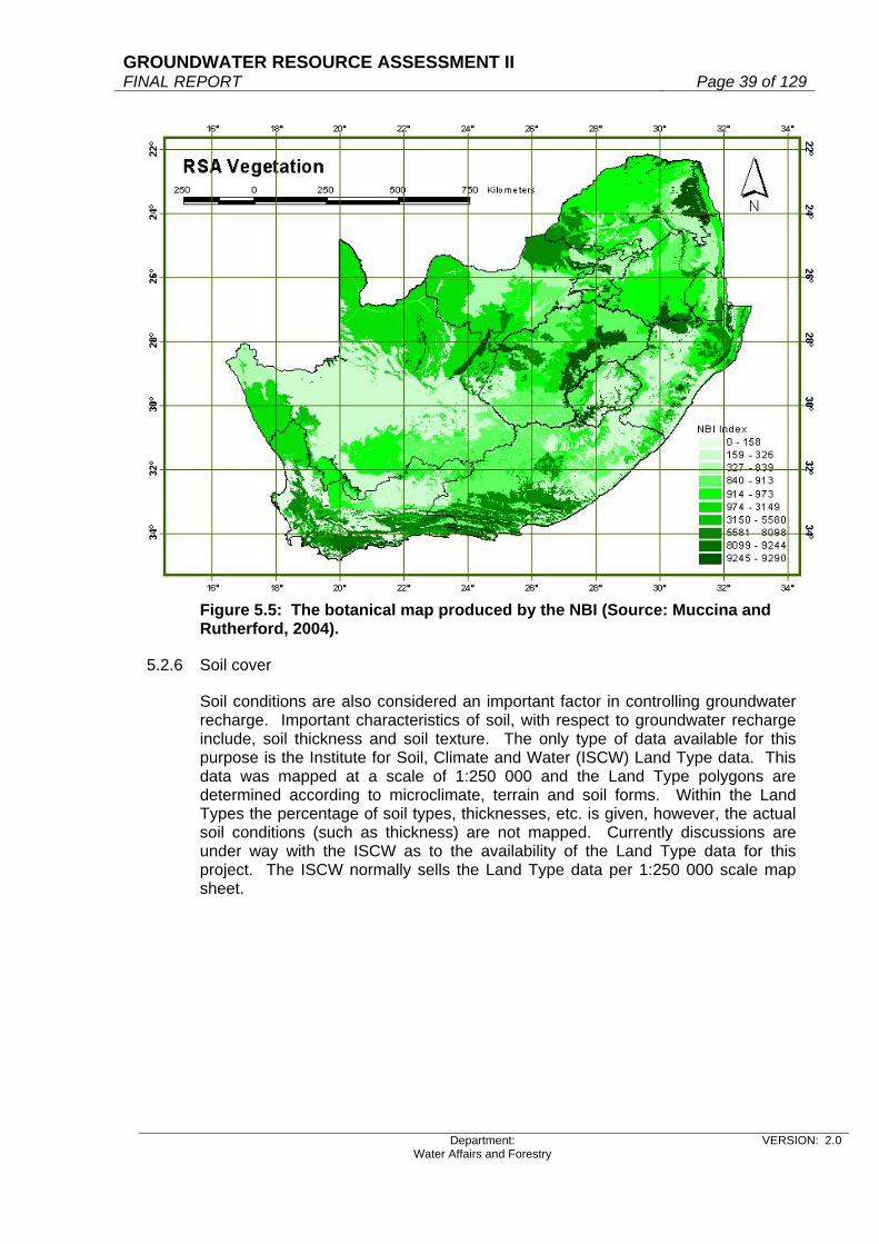
GROUNDWATER RESOURCE ASSESSMENT II FINAL REPORT Page 39 of 129
Department: Water Affairs and Forestry
VERSION: 2.0
Figure 5.5: The botanical map produced by the NBI (Source: Muccina and Rutherford, 2004).
5.2.6 Soil cover
Soil conditions are also considered an important factor in controlling groundwater recharge. Important characteristics of soil, with respect to groundwater recharge include, soil thickness and soil texture. The only type of data available for this purpose is the Institute for Soil, Climate and Water (ISCW) Land Type data. This data was mapped at a scale of 1:250 000 and the Land Type polygons are determined according to microclimate, terrain and soil forms. Within the Land Types the percentage of soil types, thicknesses, etc. is given, however, the actual soil conditions (such as thickness) are not mapped. Currently discussions are under way with the ISCW as to the availability of the Land Type data for this project. The ISCW normally sells the Land Type data per 1:250 000 scale map sheet.

GROUNDWATER RESOURCE ASSESSMENT II FINAL REPORT Page 40 of 129
Department: Water Affairs and Forestry
VERSION: 2.0
The other source of soil data is available from the WR90 CD-ROM. This soil data is very generalised and shown in Figure 5.6.
Figure 5.6: Generalised soil map (Source: WR90) The soil coverage is based on the 1989 Revised Broad Homogeneous Natural Regions map produced by the Department of Agricultural Engineering, University of Natal, Pietermaritzburg. WR90 created soil classifications that contain depth, texture and relief. Associated with the soil polygons are the following data fields: Average soil depth (mm); WR90 soil classification; dominant soil series; the name of the dominant series, percentage of the name of the dominant series, dominant soil texture, dominant series texture, percentage of dominant series texture; highest point; lowest elevation; range of elevation; and broad SIRI soil mapping units. Knowing the complexity and large spatial variability associated with soil types, it would be better for the project if the 1:250 000 scale Land Type data were obtained. It is appreciated that certain processing will be required of the Land Type data to obtain the soil data required for this project, however this is currently being negotiated with the Institute for Soil, Climate and Water.
5.2.7 Satellite imagery
The satellite imagery will play a role in assisting with the definition of recharge zones, and the delineation of riparian zones and alluvial valley floor deposits. DWAF provided GEOSS with 1998 Space Maps (11.5 Gbytes). The space maps were generated for the 1:250 000 National Land Cover mapping project, and are

GROUNDWATER RESOURCE ASSESSMENT II FINAL REPORT Page 41 of 129
Department: Water Affairs and Forestry
VERSION: 2.0
authorectified and clipped/mosaiced according to the 1:250 000 scale map outlines. The space maps for the entire country have been provided. The space maps comprise Landsat TM5 data, with a 25 m by 25 m cell size. The resolution of the imagery is coarse for the delineation of riparian zones, which typically can be in the region of 5 to 10 m wide, however, the major riparian zones can be mapped. This project will be carried out in conjunction with the national rivers data set, recently supplied by DWAF. The satellite data will also be useful for characterising broad recharge zones, indicated by rock outcrops, and mountainous regions.
5.2.8 Geology (lithology and structural data)
South African hydrogeology is characterized by predominantly secondary aquifer conditions, with groundwater occurrences being controlled by geological settings and structural features, such as faults, and fractures. It is an important requirement of this project to take into account the hydrogeological setting of aquifers and thus structurally controlled recharge events need to be predicted where possible. One of the concerns regarding the use of the ACRU model, for example, is that this model, which does predict groundwater recharge, does not take into account geological complexity and preferred flow paths along which groundwater recharge occurs. For this project it is considered important that detailed geological data be used. The Council for Geoscience (CGS) has released a 1:1 million scale data set for the geology of the whole of South Africa (Figure 5.7). The Council have however recently released a 1:250 000 scale geological coverage for the whole of South Africa. This coverage was derived from merging the individual 1:250 000 geological data sets. The national 1:250 000 scale data set is not entirely complete and there is an area in the northern Cape that has not yet been completed. This is not seen as being problematic as the 1:1 million scale data will be used to fill in these “gaps”. A structural geology data set has also been completed at the scale of 1:250 000 and will also be beneficial to this project. A request has been submitted to the Council for Geoscience for the use of the 1:250 000 scale data sets (both lithological and structural data) and at the time of writing this report, the data had not yet been received from the Council for Geoscience. A subset of the 1:250 000 scale geological coverage has been tested in a pilot study area and it will definitely be of great value to this project, due to its more detailed accuracy. The liaison person for obtaining the 1:250 000 scale geological data from the Council for Geoscience is Dr. Manie Brynard.

GROUNDWATER RESOURCE ASSESSMENT II FINAL REPORT Page 42 of 129
Department: Water Affairs and Forestry
VERSION: 2.0
Figure 5.7: Geological map of South Africa, scale 1:1 million (Source: Council for Geoscience)
5.2.9 Groundwater quality
Regarding the chloride mass balance method, which is going to be carried out for this project, it is necessary to have the chloride concentration of groundwater (as well as the chloride concentration of rainwater, which has already been discussed). The Water Research Commission (WRC) has funded studies into characterization of the chemistry of South African groundwater. The chemistry data were obtained from the Water Research Commission. However, the compilation of chemistry maps was delivered in Adobe® pdf format. On enquiry, although the data were analysed in a GIS, the resultant GIS data and maps were not provided to the WRC, only pdf files of the maps. The person responsible for the work (Milo Simonic) has left South Africa and the GIS files are not available. As the analysis for this project is to be carried out in GIS, it is essential that GIS format data be obtained. In order to do this, a “GEO-request” was submitted to DWAF for all the latest chloride values per borehole throughout the country. These data have been received and the distribution of boreholes is shown in Figure 5.8.
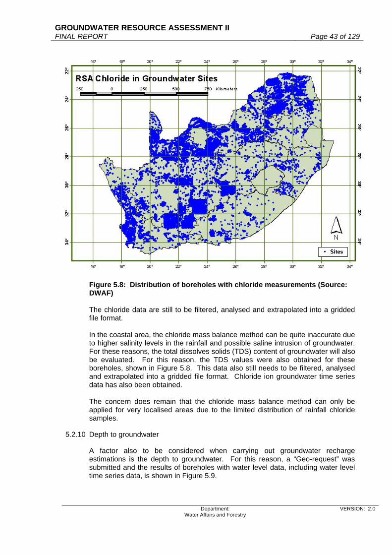
GROUNDWATER RESOURCE ASSESSMENT II FINAL REPORT Page 43 of 129
Department: Water Affairs and Forestry
VERSION: 2.0
Figure 5.8: Distribution of boreholes with chloride measurements (Source: DWAF) The chloride data are still to be filtered, analysed and extrapolated into a gridded file format. In the coastal area, the chloride mass balance method can be quite inaccurate due to higher salinity levels in the rainfall and possible saline intrusion of groundwater. For these reasons, the total dissolves solids (TDS) content of groundwater will also be evaluated. For this reason, the TDS values were also obtained for these boreholes, shown in Figure 5.8. This data also still needs to be filtered, analysed and extrapolated into a gridded file format. Chloride ion groundwater time series data has also been obtained. The concern does remain that the chloride mass balance method can only be applied for very localised areas due to the limited distribution of rainfall chloride samples.
5.2.10 Depth to groundwater
A factor also to be considered when carrying out groundwater recharge estimations is the depth to groundwater. For this reason, a “Geo-request” was submitted and the results of boreholes with water level data, including water level time series data, is shown in Figure 5.9.

GROUNDWATER RESOURCE ASSESSMENT II FINAL REPORT Page 44 of 129
Department: Water Affairs and Forestry
VERSION: 2.0
Figure 5.9: Boreholes with time series water level data (Source: DWAF) It is considered necessary to obtain time series water level data as well, so as to be able to determine the rainfall/recharge cut-off values per quaternary catchment. The approach is to evaluate rainfall patterns in close proximity to boreholes with time series water level data. The time series water level data will have to be scrutinized for groundwater abstraction impacts on the water levels, as essentially only naturalized fluctuations are required. Where valid groundwater level fluctuation data is available, time series rainfall data will be requested from the South African Weather Services and compared to the water level graphs. This will require detailed and time consuming analysis, however is considered one of the best ways for assessing the cut-off amount of rainfall, below which no groundwater recharge occurs.
5.2.11 Groundwater recharge
Vegter (1995) produce a map presenting a countrywide picture of groundwater recharge. Although recharge is expressed quantitatively, the map is to be considered as depicting broad trends rather than laying claim to accurate regional recharge figures. Nevertheless, it is considered to provide a fair estimate of the wide range of values. The recharge map is based on: a regionalised baseflow map in the eastern and southern parts of SA; effective rainfall; rainfall and recharge estimates for certain areas (where recharge is only considered if > 15 mm rainfall occurs per day); and results obtained from literature studies.

GROUNDWATER RESOURCE ASSESSMENT II FINAL REPORT Page 45 of 129
Department: Water Affairs and Forestry
VERSION: 2.0
Figure 5.10: Groundwater Recharge (Source: Vegter, 1995) The recharge map produced by Vegter (1995) does not take into account many of the factors that control groundwater recharge, and this project will attempt to do so. However, it must be noted, that although Vegter (1995) did not take into account these factors, his results must be taking into account when assessing revised recharge values. Further to producing the recharge map, Vegter (1995) also produced a table of actual sites where recharge studies have been carried out. Fortunately, these studies have geographic coordinates and can be used for this project. The distribution of these study sites is shown in Figure 5.11 below. It is anticipated that this database showing where point recharge estimates have been calculated will be expanded, as all the results of the literature study carried out, will be added to this database.
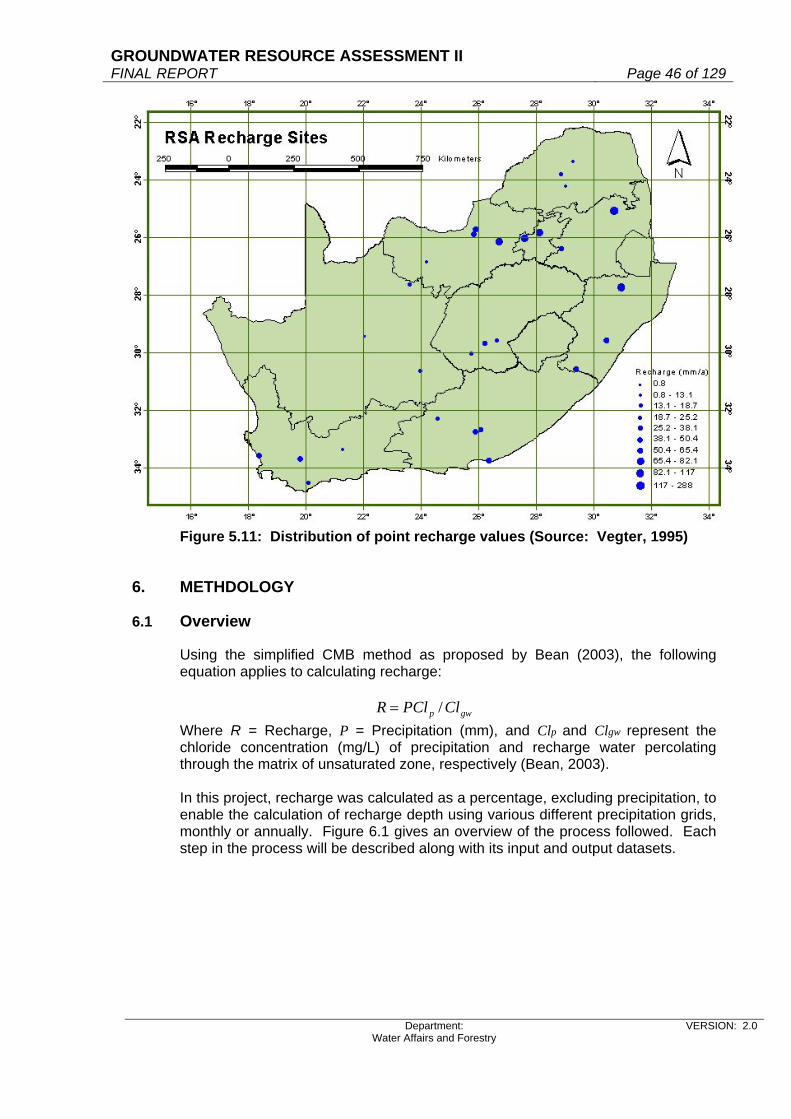
GROUNDWATER RESOURCE ASSESSMENT II FINAL REPORT Page 46 of 129
Department: Water Affairs and Forestry
VERSION: 2.0
Figure 5.11: Distribution of point recharge values (Source: Vegter, 1995)
6. METHDOLOGY
6.1 Overview
Using the simplified CMB method as proposed by Bean (2003), the following equation applies to calculating recharge:
gwp ClPClR /=
Where R = Recharge, P = Precipitation (mm), and Clp and Clgw represent the chloride concentration (mg/L) of precipitation and recharge water percolating through the matrix of unsaturated zone, respectively (Bean, 2003). In this project, recharge was calculated as a percentage, excluding precipitation, to enable the calculation of recharge depth using various different precipitation grids, monthly or annually. Figure 6.1 gives an overview of the process followed. Each step in the process will be described along with its input and output datasets.

GROUNDWATER RESOURCE ASSESSMENT II FINAL REPORT Page 47 of 129
Department: Water Affairs and Forestry
VERSION: 2.0
Figure 6.1: Overview of the recharge calculation process used in this project
6.2 CMB method
6.2.1 Clp: Chloride in rainfall
Rainfall chloride values were obtained from DWAF, Shafick Adams and the NGDB. Time-series data for 74 stations specifically equipped for Clp collection were supplied by DWAF. Table 6.1 outlines the data with its data sources.
Table 6.1: Data sources for rainfall chloride
Data Source No of data locations Time-series data from Location of values
Coast 10 Adams 18 Adams (one value per point) Inland 8
Coast 44 GW 5 DWAF
Inland 151 Coast 5
DWAF 74 NGDB
(one value per point) Inland 2 Significant spatial and temporal variations have been observed in Clp concentrations during other studies (Beekman et al., 1997; Beekman and Sungaro, 2000). According to Bean (2003), “it is the observed partitioning of

GROUNDWATER RESOURCE ASSESSMENT II FINAL REPORT Page 48 of 129
Department: Water Affairs and Forestry
VERSION: 2.0
precipitation chloride concentration data that is of importance from a recharge estimation perspective”. In his case studies at Bloemfontein and Hotazel (Table 6.2), Bean (2003) suggested that values > 5mg/L represent site-specific enrichment within the given sampling period and would result in an over-estimation of recharge (Bean, 2003). Bean (2003) suggests that concentrations with values ≤ 5 mg/L represent background conditions, as also assumed by Beekman et al. (1997). This principal (excluding values 5 mg/L) was applied to data for stations found inland (i.e. not within the defined coast). For the coast, all values were considered since very high values have been reported, e.g. 26 at Struisbaai by Weaver & Talma (2002). Five stations (DWAF) appeared to have excessively high values for rainfall chloride (varying between 80 and 1885). These values were not considered in the analysis, the assumption being that these values were more in line with groundwater chloride values. Data from Adams without directly reported coordinates, were not used to derive the equations, but were used later for the validation of the final rainfall chloride surface. Coordinates from the nearest town were taken. Seventy-nine rainfall chloride locations (16 from Adams, 63 from DWAF) were selected for processing and are indicated on the map (Figure 6.2). Table 6.2: Chloride concentration of precipitation, and rainfall at sites in Bloemfontein and Hotazel for the period 2002-2003. (Source: Bean, 2003)
Bloemfontein Hotazel Month Rainfall Chloride Rainfall Chloride
February 36.1 0.80 70.0 1.72 March 51.0 0.53 80.0 3.55 April 40.4 1.23 29.5 12.22 May 31.0 0.49 42.5 16.26 June 6.0 0.58 14.0 2.21 July 0.0 0.00 0.0 0.00 August 99.0 0.49 30.0 1.98 September 10.0 3.12 6.0 19.78 October 35.5 10.22 8.0 12.76 November 20.0 10.37 27.5 11.63 December 98.1 0.24 92.5 1.97 January 50.0 0.22 19.0 29.23 Total rainfall (mm) 477.1 419.0 Weighted average - All data 1.7 6.7
Weighted average <5mg/L 0.6 2.4

GROUNDWATER RESOURCE ASSESSMENT II FINAL REPORT Page 49 of 129
Department: Water Affairs and Forestry
VERSION: 2.0
Figure 6.2: Location of rainfall chloride collection stations These data, in combination with the following input data sets, were used to derive equations for chloride in rainfall (Clp) as done by Adams (2004).
Mean Annual Precipitation Elevation Distance to coast
6.2.1.1 Mean Annual Precipitation
Precipitation was calculated from the MAP grid (Figure 6.3) produced by Schulze (1997) and worked to a 1 X 1 km grid.

GROUNDWATER RESOURCE ASSESSMENT II FINAL REPORT Page 50 of 129
Department: Water Affairs and Forestry
VERSION: 2.0
Figure 6.3: Mean Annual Precipitation (Schulze, 1997)
6.2.1.2 Elevation
The 20m DTM was obtained from DWAF and reworked to a 1 X 1 km grid (Figure 6.4). With the jagged coastline, areas less than half of the 1km2 grid cell were not included. The processed data was extended to cover the outline by extracting information from the original DTM.
6.2.1.3 Distance to coast
For the centre point of each 1km2 cell in the RSA grid, the Euclidian distance to the coast was calculated (Figure 6.5).

GROUNDWATER RESOURCE ASSESSMENT II FINAL REPORT Page 51 of 129
Department: Water Affairs and Forestry
VERSION: 2.0
Figure 6.4: The DWAF DTM reworked to 1km2 grid
Figure 6.5: Distance to the coast
6.2.1.4 Defining the coast
Adams (2004) described a process of deriving rainfall chloride values for the coastal regions within 100km of the sea. Using a GIS terrain-modelling approach, the Topographic Position Index (TPI) was defined as seen in Figure 6.6. Valid values for TPI can be found in Table 6.3. Upper slopes and ridges were used to delineate the coast.

GROUNDWATER RESOURCE ASSESSMENT II FINAL REPORT Page 52 of 129
Department: Water Affairs and Forestry
VERSION: 2.0
Table 6.3: Topographic Positional Index values
Relative slope position TPI value Upper slopes 1 Ridges 2 Mid-slopes 3 Foot slopes 4 Valleys / Flat areas 5
Figure 6.6: The topographic positional index used to delineate the coast Cut-off values were implemented. The highest empirical value determined in RSA, was 26 at Struisbaai by Weaver and Talma (2002). So a value of 30 for the coast was regarded as a suitable cut-off (Beekman, pers comm.). Highest recorded value from DWAF stations was 31 mg/L. A low value of 0.2 mg/L was implemented since it was the lowest measured value for chloride in rainfall obtained from DWAF. For inland rainfall chloride, Beekman (pers comm.) suggested a high of 1.5 mg/L as cut-off value. Table 6.4 describes the equations, R2 values and cut-off values implemented. For each of the elements a grid was calculated in ArcView 3.2 using the input dataset and the derived equation. The coast was treated separately from inland.

GROUNDWATER RESOURCE ASSESSMENT II FINAL REPORT Page 53 of 129
Department: Water Affairs and Forestry
VERSION: 2.0
Validation against smoothed dataset
y = 0.5866x + 0.7254R2 = 0.7867
0
2
4
6
8
10
12
14
16
18
0 5 10 15 20 25 30
Measured ClP
Cal
cula
ted
Cl P
Table 6.4: Equations used to derive chloride in rainfall values for the country
Input dataset (x in equation) Equations R2 Output grid
values Comments
COAST MAP (Schulze, 1997)
Clp = -5.9079Ln(x) + 42.056 0.724 -3.983 – 24.358 Clp<0 ----> 0.01
Elevation (DWAF DTM)
Clp = -3.158Ln(x) + 24.693 0.5338 0.681 – 53.779 Clp>30 ----> 30
Distance to coast Clp = 20.223e-0.046x 0.6598 0.038 – 20.223 Clp<0.2 ----> 0.2 INLAND
MAP (Schulze, 1997) Clp = 1.4322e-0.0017x 0.2689 0.006 – 1.384 Clp<0.2 ----> 0.2
Elevation (DWAF DTM) Clp = 2.1677e-0.001x 0.2637 0.07 – 2.108 Clp<0.2 ----> 0.2
Clp>30 ----> 30 The three coastal grids were summed and the mean value calculated (Output grid values were 0.577 – 23.829). The two inland grids were summed and the mean value calculated (Output grid values: 0.2 – 1.442). The resultant coastal and inland grids were combined to create the final Clp grid. Values ranged from 0.2 –23.829. The Clp grid was smoothed using a 5X5 circular filter calculating the mean (Values 0.205 – 18.838). This Clp grid was validated against the chloride in rainfall values supplied by DWAF. The correlation obtained (R2 =0.7867) is shown in Figure 6.7. The smoothed grid was calibrated using the formula y= 1.3412x - 0.082 (R2=0.7867). The range of values obtained were 0.192 – 25.183 (Figure 6.8).
Figure 6.7: Correlation between measured and calculated rainfall chloride

GROUNDWATER RESOURCE ASSESSMENT II FINAL REPORT Page 54 of 129
Department: Water Affairs and Forestry
VERSION: 2.0
Figure 6.8: Rainfall chloride
6.2.2 Clgw: Chloride in groundwater
The NGDB was trawled for all available chloride values. ZQM monitoring data was obtained from DWAF. Many outliers were identified with values varying between 1.5 mg/L and 98 625 mg/L. All values higher than seawater (19 000mg/L) were eliminated. Values then ranged from 1.5 to 18 943.1 mg/L. Other outlier data pre-1980 were also eliminated if the values were greater than 3 Standard Deviations above the mean. Clgw values for saltpans in the Northern Cape and on the West Coast were left intact. The harmonic mean of 42 662 data points of time-series data were calculated giving 28 465 locations with chloride values. The harmonic mean for each 1km2 grid cell in the RSA grid was calculated from these locations giving 21 795 populated cells. These 21 795 groundwater chloride points were interpolated using the Kriging method. A groundwater chloride surface was generated with values ranging from 2.587 to 5 855.737 mg/L. The interpolation technique smoothed the data eliminating very high and very low values for groundwater chloride. For this reason the 21 795 cells with actual groundwater chloride values were superimposed onto the interpolated groundwater chloride surface (values 1.5 – 18 943.1 mg/L) (Figure 6.9).

GROUNDWATER RESOURCE ASSESSMENT II FINAL REPORT Page 55 of 129
Department: Water Affairs and Forestry
VERSION: 2.0
Figure 6.9: Groundwater chloride values
6.2.3 The result of the CMB method
The following equation was used to calculate the recharge percentage: gwp ClClR /100% ×=
The calculation provided values between 0.006 and 79.586%. This raw recharge grid was smoothed with a mean circle with radius 5km giving a recharge percentage surface with values between 0.02 and 21.803% (Figure 6.10).
Figure 6.10: Smoothed uncalibrated recharge percentage grid
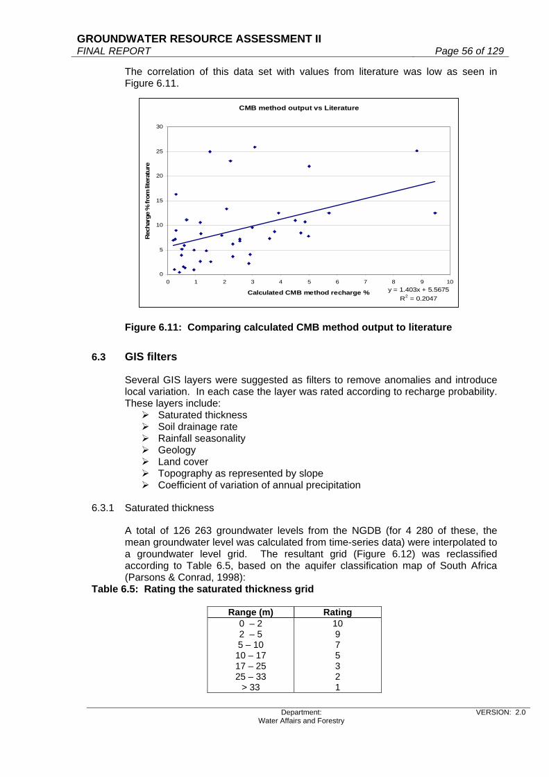
GROUNDWATER RESOURCE ASSESSMENT II FINAL REPORT Page 56 of 129
Department: Water Affairs and Forestry
VERSION: 2.0
CMB method output vs Literature
y = 1.403x + 5.5675R2 = 0.2047
0
5
10
15
20
25
30
0 1 2 3 4 5 6 7 8 9 10
Calculated CMB method recharge %
Rec
harg
e %
from
lite
ratu
re
The correlation of this data set with values from literature was low as seen in Figure 6.11.
Figure 6.11: Comparing calculated CMB method output to literature
6.3 GIS filters
Several GIS layers were suggested as filters to remove anomalies and introduce local variation. In each case the layer was rated according to recharge probability. These layers include:
Saturated thickness Soil drainage rate Rainfall seasonality Geology Land cover Topography as represented by slope Coefficient of variation of annual precipitation
6.3.1 Saturated thickness
A total of 126 263 groundwater levels from the NGDB (for 4 280 of these, the mean groundwater level was calculated from time-series data) were interpolated to a groundwater level grid. The resultant grid (Figure 6.12) was reclassified according to Table 6.5, based on the aquifer classification map of South Africa (Parsons & Conrad, 1998):
Table 6.5: Rating the saturated thickness grid
Range (m) Rating 0 – 2 2 – 5 5 – 10
10 – 17 17 – 25 25 – 33
> 33
10 9 7 5 3 2 1

GROUNDWATER RESOURCE ASSESSMENT II FINAL REPORT Page 57 of 129
Department: Water Affairs and Forestry
VERSION: 2.0
6.3.2 Soil drainage rates
The drainage rate index from Schulze (1997) was used. The drainage rates, governed by the soil texture of the subsoil, are expressed as fractions of the excess water per day (Schulze, 1997). These fractions, multiplied by 10 to give a value between 0 and 10, can be seen in Figure 6.13.
Figure 6.12: Groundwater levels interpolated from NGDB data
Figure 6.13: Drainage rate index derived from soils
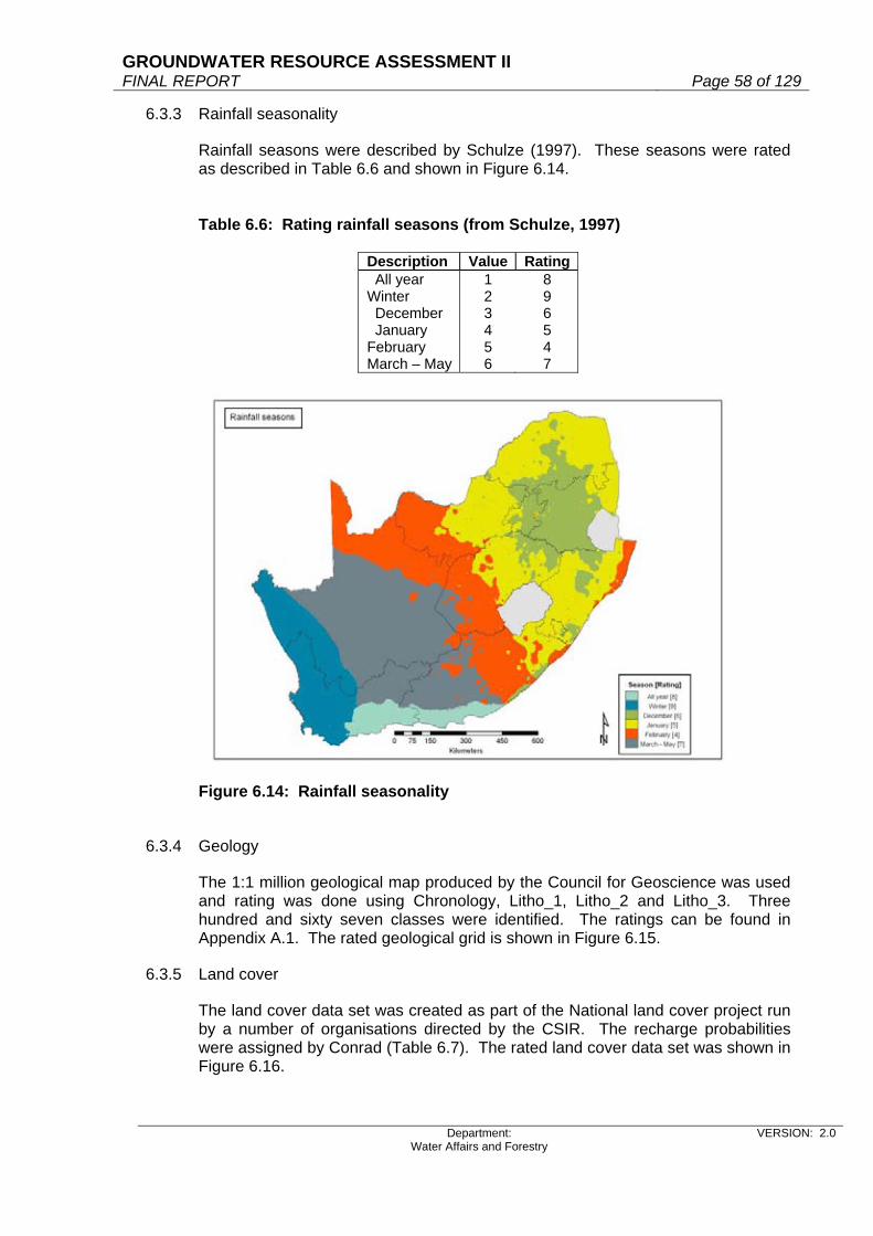
GROUNDWATER RESOURCE ASSESSMENT II FINAL REPORT Page 58 of 129
Department: Water Affairs and Forestry
VERSION: 2.0
6.3.3 Rainfall seasonality
Rainfall seasons were described by Schulze (1997). These seasons were rated as described in Table 6.6 and shown in Figure 6.14. Table 6.6: Rating rainfall seasons (from Schulze, 1997)
Description Value Rating All year Winter December January February March – May
1 2 3 4 5 6
8 9 6 5 4 7
Figure 6.14: Rainfall seasonality
6.3.4 Geology
The 1:1 million geological map produced by the Council for Geoscience was used and rating was done using Chronology, Litho_1, Litho_2 and Litho_3. Three hundred and sixty seven classes were identified. The ratings can be found in Appendix A.1. The rated geological grid is shown in Figure 6.15.
6.3.5 Land cover
The land cover data set was created as part of the National land cover project run by a number of organisations directed by the CSIR. The recharge probabilities were assigned by Conrad (Table 6.7). The rated land cover data set was shown in Figure 6.16.

GROUNDWATER RESOURCE ASSESSMENT II FINAL REPORT Page 59 of 129
Department: Water Affairs and Forestry
VERSION: 2.0
Figure 6.15: Geology rating with regards to recharge (as defined by Conrad, 2004). Figure 6.16: Rated land cover dataset
6.3.6 Topography as represented by slope
Slope was calculated from the 20m DTM obtained from DWAF. The percentage slope (Figure 6.17) was rated (Table 6.8) according to the ratings assigned in the aquifer vulnerability classification for South Africa carried out by Parsons & Conrad (1998).

GROUNDWATER RESOURCE ASSESSMENT II FINAL REPORT Page 60 of 129
Department: Water Affairs and Forestry
VERSION: 2.0
Table 6.7: Recharge ratings per land cover class description
Description Rech_Prob Barren rock 5 Cultivated: permanent - commercial dryland 9 Cultivated: permanent - commercial irrigated 9 Cultivated: permanent - commercial sugarcane 9 Cultivated: temporary - commercial dryland 9 Cultivated: temporary - commercial irrigated 9 Cultivated: temporary - semi-commercial/subsistence dryland 9 Degraded: forest and woodland 6 Degraded: herbland 7 Degraded: shrubland and low Fynbos 9 Degraded: thicket & bushland (etc) 8 Degraded: unimproved grassland 9 Dongas & sheet erosion scars 3 Forest 5 Forest and Woodland 5 Forest plantations 4 Herbland 6 Improved grassland 8 Mines & quarries 8 Shrubland and low Fynbos 8 Thicket & bushland (etc) 7 Unimproved grassland 9 Urban / built-up land: commercial 5 Urban / built-up land: industrial / transport 5 Urban / built-up land: residential 5 Urban / built-up land: residential (small holdings: bushland) 6 Urban / built-up land: residential (small holdings: grassland) 6 Urban / built-up land: residential (small holdings: shrubland) 6 Urban / built-up land: residential (small holdings: woodland) 6 Waterbodies 10 Wetlands 10
Table 6.8: Recharge ratings per slope (%)
Slope(%) Rating
0 - 2 10 2 - 6 9 6 -12 5
12 -18 3 >18 1
6.3.7 Coefficient of variation of annual precipitation
This layer was added to improve the quality of the calibration. Coefficient of variation of annual precipitation was obtained from Schulze (1997), and rated into 10 classes (Figure 6.18); a lower percentage CV was given a higher recharge rating.

GROUNDWATER RESOURCE ASSESSMENT II FINAL REPORT Page 61 of 129
Department: Water Affairs and Forestry
VERSION: 2.0
Figure 6.17: Slope (%) rated
Figure 6.18: Recharge rated coefficient of variation of annual precipitation

GROUNDWATER RESOURCE ASSESSMENT II FINAL REPORT Page 62 of 129
Department: Water Affairs and Forestry
VERSION: 2.0
6.4 Filter and calibrate
6.4.1 GIS filtering
The CMB calculated recharge grid was filtered using the various GIS layers described previously. As suggested by Bean (pers comm.), saturated thickness (mean groundwater level (mbgl)); soil drainage as described by Schulze (1997); and rainfall seasons were used. Geology and land cover (rated by Conrad) as well as topography and coefficient of variation of annual precipitation were added as filter layers. Recharge values from the literature were supplied by Alan Woodford (Table A.2). Using multiple regression, the CMB output and GIS filter layers were calibrated against known recharge points only where recharge had been calculated by the CMB method (42 points). The coefficients for the regression equation are given in Table 6.9. The R2 was 0.4519.
Table 6.9: Coefficients for regression equation
Layer CoefficientIntercept -7.97225 Recharge (calculated) 1.013994 Land cover 0.194155 Geology 0.291186 Saturated thickness 0.853438 Soil drainage rates 1.287624 Rainfall seasonality 0.40496 Topography -0.76121 CV of annual precipitation 1.500128
The relationship of CMB calculated recharge after being calibrated with the GIS filter layers with point recharge values from literature is given in Figure 6.19. The final recharge grid was smoothed using a 5km circular function. Values for the calibrated recharge percentage grid were in the range –4.056 – 31.828. Values less than 0.01 were set to 0.01 and the grid was clipped to RSA boundaries (Figure 6.20). The total recharge volume per quaternary catchment was calculated using mean annual precipitation (Schulze, 1997) and summed for the country. A value of 52.7 kMm3 was calculated which equates to a mean recharge of 9% over the whole country. This appears to be higher than expected, due to the low number of calibration input data points (42).

GROUNDWATER RESOURCE ASSESSMENT II FINAL REPORT Page 63 of 129
Department: Water Affairs and Forestry
VERSION: 2.0
Figure 6.19: GIS-filtered recharge % vs. recharge values from literature
Figure 6.20: Filtered recharge percentage grid Values per quaternary catchment were available from the GRAII GW/SW interaction project, but were unsuitable to use in the GIS linear regression calibration process, since the seven filter parameters described in the GIS filtering process would have to be smoothed per catchment, reducing their specificity. The further calibration required for the GIS filtered recharge grid was done using the available set of values per quaternary catchment.
6.4.2 Calibrating with regression output from GRAII GW/SW interaction
Recharge values per quaternary catchment were modelled as part of the GRAII GW/SW interaction project. A relationship was established between rainfall and
Calibrating mean recharge percentage
y = x + 3E-14R2 = 0.4519
0
5
10
15
20
25
30
0 5 10 15 20
Calculated
Mea
sure
d

GROUNDWATER RESOURCE ASSESSMENT II FINAL REPORT Page 64 of 129
Department: Water Affairs and Forestry
VERSION: 2.0
GIS-filtered recharge vs GW/SW interaction recharge y = 0.6417x - 1.2
R2 = 0.6947
-5
0
5
10
15
20
25
30
35
0 5 10 15 20 25 30 35
GIS-filtered recharge %
GW
/SW
inte
ract
ion
Rec
harg
e %
recharge values for all quaternary catchments-were derived from this equation (Figure 21).
Figure 6.21: Rainfall-recharge relationship from GW/SW interaction When comparing the GIS-filtered recharge grid (57kMm3) summarized per catchment with the GW/SW interaction values, the correlation found in Figure 6.22 was obtained. The R2 value of 0.6947 was most promising.
Figure 6.22: GIS-filtered recharge per catchment correlated with recharge from GW/SW interaction The correlation equation was applied to the GIS-filtered recharge grid. Values ranging between -1.193583 and 19.223885 were obtained. Negative values were set to 0.00001. The resultant recharge percentage grid can be found in Figure 6.23.
Modelled recharge - Rainfall relationship
y = 4E-07x2.8007
R2 = 0.6204
0.1
1
10
100
1000
0 500 1000 1500 2000 2500
Rainfall
Rec
harg
e
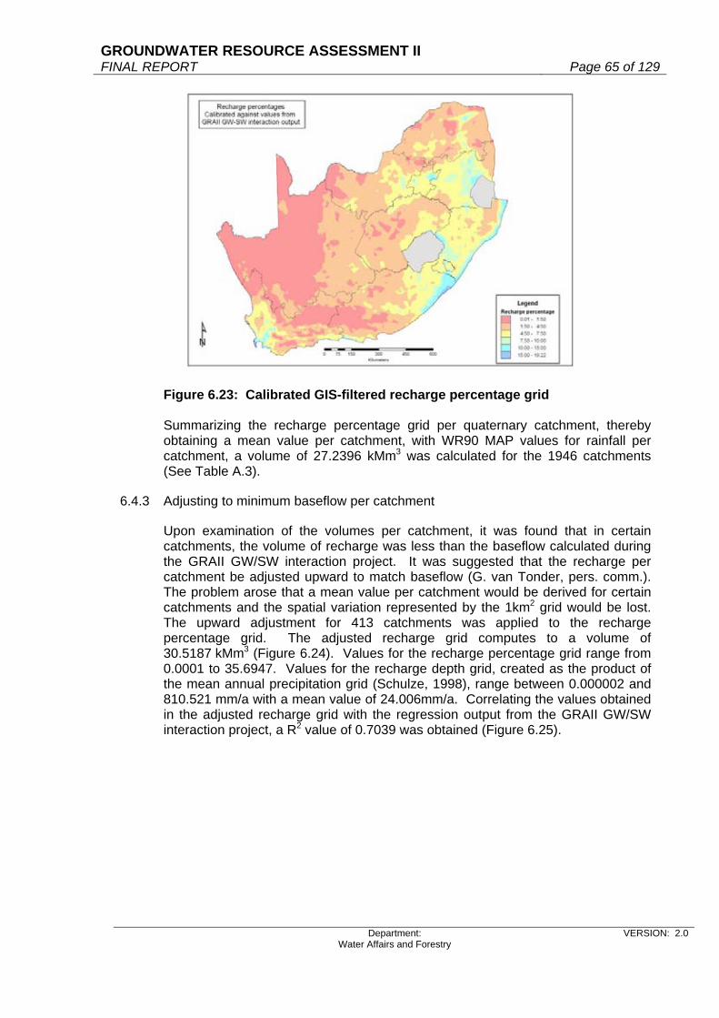
GROUNDWATER RESOURCE ASSESSMENT II FINAL REPORT Page 65 of 129
Department: Water Affairs and Forestry
VERSION: 2.0
Figure 6.23: Calibrated GIS-filtered recharge percentage grid Summarizing the recharge percentage grid per quaternary catchment, thereby obtaining a mean value per catchment, with WR90 MAP values for rainfall per catchment, a volume of 27.2396 kMm3 was calculated for the 1946 catchments (See Table A.3).
6.4.3 Adjusting to minimum baseflow per catchment
Upon examination of the volumes per catchment, it was found that in certain catchments, the volume of recharge was less than the baseflow calculated during the GRAII GW/SW interaction project. It was suggested that the recharge per catchment be adjusted upward to match baseflow (G. van Tonder, pers. comm.). The problem arose that a mean value per catchment would be derived for certain catchments and the spatial variation represented by the 1km2 grid would be lost. The upward adjustment for 413 catchments was applied to the recharge percentage grid. The adjusted recharge grid computes to a volume of 30.5187 kMm3 (Figure 6.24). Values for the recharge percentage grid range from 0.0001 to 35.6947. Values for the recharge depth grid, created as the product of the mean annual precipitation grid (Schulze, 1998), range between 0.000002 and 810.521 mm/a with a mean value of 24.006mm/a. Correlating the values obtained in the adjusted recharge grid with the regression output from the GRAII GW/SW interaction project, a R2 value of 0.7039 was obtained (Figure 6.25).
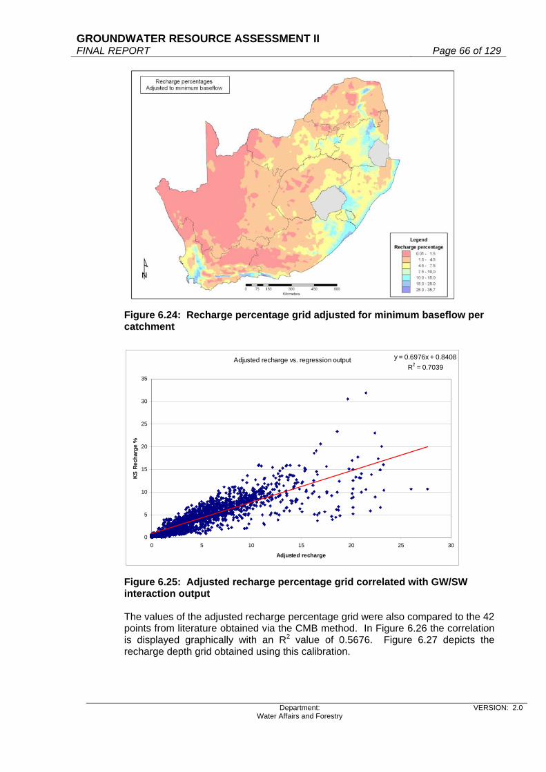
GROUNDWATER RESOURCE ASSESSMENT II FINAL REPORT Page 66 of 129
Department: Water Affairs and Forestry
VERSION: 2.0
Adjusted recharge vs. regression output y = 0.6976x + 0.8408R2 = 0.7039
0
5
10
15
20
25
30
35
0 5 10 15 20 25 30
Adjusted recharge
KS
Rec
harg
e %
Figure 6.24: Recharge percentage grid adjusted for minimum baseflow per catchment
Figure 6.25: Adjusted recharge percentage grid correlated with GW/SW interaction output The values of the adjusted recharge percentage grid were also compared to the 42 points from literature obtained via the CMB method. In Figure 6.26 the correlation is displayed graphically with an R2 value of 0.5676. Figure 6.27 depicts the recharge depth grid obtained using this calibration.
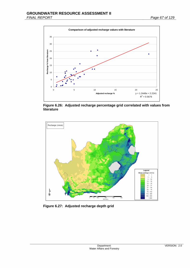
GROUNDWATER RESOURCE ASSESSMENT II FINAL REPORT Page 67 of 129
Department: Water Affairs and Forestry
VERSION: 2.0
Comparison of adjusted recharge values with literature
y = 1.2449x + 2.2241R2 = 0.5676
0
5
10
15
20
25
30
35
0 5 10 15 20 25
Adjusted recharge %
Rec
harg
e %
from
lite
ratu
re
Figure 6.26: Adjusted recharge percentage grid correlated with values from literature
Figure 6.27: Adjusted recharge depth grid

GROUNDWATER RESOURCE ASSESSMENT II FINAL REPORT Page 68 of 129
Department: Water Affairs and Forestry
VERSION: 2.0
Adjusted recharge compared to Vegter's recharge per quaternary catchment
y = 0.4741x + 19.944R2 = 0.6651
0
50
100
150
200
250
0 50 100 150 200 250 300 350 400 450
Vegter recharge (mm)
Adj
uste
d re
char
ge (m
m)
6.5 Validation
The recharge volumes from recharge grids derived via various methods were compared. The various recharge grids were summarised for the 1946 quaternary catchments in the WR90 dataset. If recharge depth was not given, the recharge was quantified using the WR90 MAP as rainfall input. The SRECH dataset of Vegter (1995) was extrapolated over Swaziland and then converted to a grid. The recharge depth was summarised per quaternary catchment and total volumes calculated. Total rainfall was computed using the WR90 MAP (mean annual precipitation). The comparison can be found in Table 6.10. Table 6.10: Comparison of rainfall volumes with recharge volumes using different calibration methods
Recharge (km3/a) Recharge Mean Min Max
GIS filtered recharge grid 52.75 9.0%
41.30 7.1%
66.53 11.4%
GIS recharge grid calibrated with GRAII GW-SW output (unmodified)
27.24 4.7%
20.03 3.4%
36.12 6.2%
Adjusted recharge grid 30.52 5.2%
22.55 3.9%
40.55 6.9%
Recharge according to Vegter (1995) 33.82 5.8%
27.39 4.7%
42.88 7.3%
Rainfall volume (WR90) 585.46 km3/a The values found in the adjusted recharge grid were also correlated with the values obtained by Vegter (1995). The comparison can be seen in Figure 6.28. The R2 for the correlation is 0.6651.
Figure 6.28: Adjusted recharge depth grid correlated with Vegter’s recharge

GROUNDWATER RESOURCE ASSESSMENT II FINAL REPORT Page 69 of 129
Department: Water Affairs and Forestry
VERSION: 2.0
7. RECHARGE THRESHOLD VALUES
7.1 Introduction
This chapter describes the groundwater recharge threshold values calculated per quaternary catchment.
7.2 Background
This chapter addresses the issue of “Recharge Threshold Value” (RTV). This is the value, which relates to precipitation and indicates a cut-off or threshold value, below which no direct groundwater recharge is likely to occur. In other words, the RTV is the minimum amount of rainfall required to initiate recharge. A low RTV means that recharge occurs rapidly in most years, and is associated with the wetter temperate areas. A high RTV indicates longer periods of no recharge, with associated lower and more variable rainfall patterns. If precipitation does not meet the RTV in a catchment, then necessary steps and precautionary measures will have to be taken to ensure groundwater depletion or “mining” does not occur, assuming groundwater abstraction is occurring. Or, if mining is occurring, then it is done on a managed basis. It is important to stress that the RTV is a generalized and approximate figure, with large embedded uncertainty. This is due to the inability to quantify, both on a temporal and spatial scale, the many factors that influence the RTV. These factors include the rainfall season and characteristics, the climate conditions, the geomorphological and soil characteristics, the hydrogeological parameters, and antecedent soil moisture conditions. The algorithm used in this national scale project should optimally include hourly rainfall data in close proximity to hourly measured groundwater levels. However, we do not have hourly rainfall and groundwater level data for each and every quaternary catchment across the country. Thus a modelled approach is adopted in this project. However, for a more detailed, small area study such detailed data is most relevant. There have been a few references to RTV in the literature and the most comprehensive review of RTV is by Bean (2003). Prior to discussing the results Bean obtained, Bredenkamp et al (1995) commented that chloride profiles indicated that regional recharge falls into two categories, namely:
Areas where recharge occurs regularly Areas of sporadic recharge in the interior parts of the country, where recharge
only occurs if the average annual rainfall exceeds a threshold value of about 290 mm (and average annual rainfall does not exceed 600 mm per annum).
It is reasonable to expect the RTV to be lower and for recharge to occur more quickly, if recharge water enters aquifers via preferential pathways as opposed to the matrix. Bean (2003) confirms, using isotopic data, that preferential flow path and matrix derived recharge does differ. Thus, RTVs can be sub-divided into the following components: RTVave: Average threshold to be exceeded before recharge occurs. RTVpp Threshold to be exceeded before preferential flow recharge occurs.
GROUNDWATER RESOURCE ASSESSMENT II FINAL REPORT Page 70 of 129
Department: Water Affairs and Forestry
VERSION: 2.0
RTVmat: Threshold to be exceeded before matrix recharge occurs. Detailed analysis is required to differentiate between matrix and preferential flow path recharge and such detail is not possible to obtain for this project. From case studies carried out by Bean (2003), he suggests an annual RTV of:
150 mm for the Hotazel area, 150 mm for the Petrusburg area,
o RTVpp being 15 mm o RTVmat being 200 mm
Not given for Kriel, however the following is noted: o RTVpp of 60 mm o RTVmat being 135 mm.
In De Aar, Vegter (1992) compared daily rainfall information with water level fluctuations and found that recharge occurred only when daily rainfall exceeded 15mm.
7.3 Methodololgy
If time series data of rainfall and groundwater level fluctuations can be obtained in close proximity, then an analysis of these data can be carried out. Ideally these data need to be collected on a daily basis. The results of the analysis will provide an RTV for an individual rainfall event. The Cumulative Rainfall Departure (CRD) method is a good analytical method if the above-mentioned data (including the specific yield of an aquifer) are known. Bean (2003) mentions that recent work undertaken in semi-arid Central Australia by Harrington et al., (2002), suggests that the recharge threshold can be predicted through an understanding of stable isotopes abundances in rainfall and groundwater. Bean (2003) developed a new stable isotope-based technique, called the Modified Amount Effect (MAE) Method. This technique provides insight into episodic recharge processes by estimating the proportion of preferential pathway-to-matrix-derived flow entering an aquifer, and the amount of rainfall required to initiate recharge via the respective flow paths. Significantly, the proportion of bypass flow can be determined without undertaking expensive and time consuming unsaturated zone studies, both factors often of primary concern when undertaking recharge investigations in developing countries.
Bean (2003) states that four recharge thresholds can be identified using the MAE Method; the low and high recharge thresholds that must be exceeded before recharge occurs via preferential pathways or the matrix, respectively. These represent threshold limits, the low value only of importance following successive months of wet weather, the high value representing the rainfall that must be received to restore an aquifer system to equilibrium after prolonged dry spells. Once these thresholds are known, the recharge history of a site can be modelled using available rainfall data by adapting the Cumulative Rainfall Departure (CRD) method. An important finding by Bean (2003) is that in those semi-arid to arid areas where most recharge water enters the aquifer via the matrix, the period of time that elapses between successive rainfall events that exceed the matrix recharge threshold often extends to scores of years.

GROUNDWATER RESOURCE ASSESSMENT II FINAL REPORT Page 71 of 129
Department: Water Affairs and Forestry
VERSION: 2.0
Thus, through an understanding of the episodic nature of recharge in semi-arid and arid areas, and therefore the thresholds that must be exceeded before recharge occurs, geohydrologists are better able to provide scenarios of recharge status. In terms of aquifer management, it is therefore important to know whether the suggested recharge is actually occurring, and if so, the recharge threshold, particularly in semi-arid and arid environments where recharge is episodic in character. In the absence of long-term site rainfall or water level data, an understanding of environmental tracers present in recharge waters can be of some benefit, particularly when investigating aquifers containing young groundwater, and receiving significant recharge (Cook et al., 2001) The limitations of the MAE method, in the context of the GRA II Project, is that the isotope data available are of limited geographic spread, and it will not be valid to extrapolate these point values to a national scale. However, this method does highlight the importance of collecting isotope data for recharge and RTV assessments. One of the methods considered for this study was to use the generated 1km by 1km gridded recharge values and to compare these to the Mean Annual Precipitation values per quaternary catchment. The method used to obtain these recharge values is contained in Report 3aC. However, this is not a time series based approach, but rather an assessment of these long term values for each quaternary catchment. Included in the recharge values, are factors such as rainfall seasonality. Figure 7.1 shows the results of plotting the data for a particular case-study quaternary catchment (G30F). The x-axis intercept is then considered the RTV for that particular catchment. For catchment G30F, an RTV of 100 mm is obtained. Catchment G30F is considered as it is a catchment currently being studied in detail as part of an RDM project (Nel, 2005 and DWAF, 2004e). Referring to Figure 7.1, the concern is the wide distribution of the data, relating to different geological terrains and rainfall patterns within a catchment and the low correlation coefficient obtained between the rainfall and recharge relationship. For these reasons additional approaches to calculating RTV were considered and adopted.

GROUNDWATER RESOURCE ASSESSMENT II FINAL REPORT Page 72 of 129
Department: Water Affairs and Forestry
VERSION: 2.0
Figure 7.1: Recharge threshold value calculated for G30F Bean (2003) noted that based on 98 years of rainfall for Petrusburg, the average monthly rainfall is 35.7mm, and importantly this value also represents the long term recharge threshold for an aquifer in equilibrium if seasonal conditions are ignored. In theory therefore, there would be no change in water levels if 35.7mm of rain fell at the site every month. However, in nature this does not occur and prolonged periods of below average rainfall are evident throughout the Petrusburg data set. Thus, in order to restore equilibrium conditions such that the average recharge threshold again decreases to 35.7mm/month, a given catchment must receive above average rainfall. This observation is significant because it indicates that, for a given aquifer in semi-arid and arid areas, multiple thresholds will be represented in site water level data. Besides the added complexity of suggesting that multiple RTVs exist for a given aquifer, the above suggestion is interesting in that the Mean Annual Precipitation value can possibly be used as an indicator of RTV, assuming the catchment is not stressed and over-exploited. For comparison purposes the example given in Figure 1 indicates an RTV of 100mm and the WR90 data indicates a MAP of 123mm. Thus in the delivery of the final results (Appendix A), the MAP per quaternary catchment is given as well as the monthly RTV. Please note the MAP is an annual value and the RTV given is a monthly value. Following on from the discussion above it was felt by the project team that another and more accurate approach should be considered in calculating RTV per quaternary catchment. Thus monthly rainfall data was purchased from the Agricultural Research Council for the time period January 2000 to August 2004. This data is provided for the entire country on a 1km by 1 km grid. Based on the modelling carried out to determine groundwater recharge, the rainfall data and groundwater recharge data was then aggregated up to the quaternary catchment scale and compared. The results, plotted on a semi-log graph, of the comparison are shown for a single catchment quaternary catchment in Figure 7.2.
Recharge vs MAPG30F
y = 5.3621Ln(x) - 24.685R2 = 0.3224
-5.00
0.00
5.00
10.00
15.00
20.00
25.00
0 50 100 150 200 250 300 350 400 450 500 550 600 650 700 750 800 850
MAP (mm/a)
Rec
harg
e (m
m/a
)

GROUNDWATER RESOURCE ASSESSMENT II FINAL REPORT Page 73 of 129
Department: Water Affairs and Forestry
VERSION: 2.0
Figure 7.2: A semi-log plot of monthly rainfall versus recharge for catchment G30F, plotted for 56 months The cumulative distribution of monthly recharge, together with a probability distribution based on a presumed normal distribution, indicating percentage non-exceedence, was then used, at the 98% confidence interval to determine a recharge value (Figure 7.3). This value indicates when recharge is likely to occur (at the 98% level of confidence) and is then related to a monthly rainfall value, which is the threshold value for that particular catchment. Thus for the example of catchment G30F, a MAP of 285 mm is noted, which can be considered the annual RTV and from the analysis of monthly data a value of 102 mm is obtained, which is considered the monthly RTV. If more than 102 mm falls per month in the rainy season (winter) recharge will most probably occur. If more than 102 mm of rain fell in the summer months (improbable) recharge is still likely not to occur due to the high evapotranspiration rates and soil temperatures. The distribution of rainfall categories is shown in Figure 7.4.
G30F
0.00
0.01
0.10
1.00
10.00
0 20 40 60 80 100 120 140
Rainfall (mm)
Rech
arge
(mm
)

GROUNDWATER RESOURCE ASSESSMENT II FINAL REPORT Page 74 of 129
Department: Water Affairs and Forestry
VERSION: 2.0
Figure 7.3: A probability plot indicating a recharge value of 5mm at the 98% confidence limit.
Figure 7.4: Rainfall seasons for South Africa (Schulze, 1997)
0%10%20%30%40%50%60%70%80%90%
100%
0 1 2 3 4 5 6 7
Recharge (mm)
Pro
babi
lity
of n
on e
xcee
danc
e
G30F

GROUNDWATER RESOURCE ASSESSMENT II FINAL REPORT Page 75 of 129
Department: Water Affairs and Forestry
VERSION: 2.0
8. CURRENT SHORTCOMINGS An increase in the number of rainfall chloride values will improve the accuracy of the calibration of the recharge grid. In addition calculation of actual evapotranspiration will be beneficial. For assessment of an RTV, it is preferable to have daily time series data of rainfall and groundwater levels (in close proximity). However, for this project an RTV has to be calculated for each quaternary catchment and there are insufficient time series data sets across the country to support this type of analysis. Thus the current method of calculating RTVs is not based on time series data of rainfall and groundwater levels, but rather on an aggregated statistical value, based on “recharge probability non-exceedence”. It must be noted that an additional incentive of monitoring rainfall and groundwater levels across the country would be to enable the improved assessment of RTVs. This benefit should be included when the New National Groundwater Monitoring Network is addressed (pers. comm., E van Wyk, 2005).
9. RECOMMENDATION For calculating recharge and RTV, a more detailed approach is suggested in that stressed catchments should be determined and the modelling of recharge processes could be significantly refined if long term rest water levels and stable isotopes data is available for the aquifer. It is strongly recommended that monthly rainfall, rest groundwater levels, stable isotopes and chemistry data be collected. This data should be collected from rainwater, surface and groundwater if possible. In addition, stressed aquifer should be addressed and then sites selected on the basis of land use, climate zone, and aquifer type, with a view to extrapolating the results elsewhere across the country. The data needs to be stored and managed using the DWAF centralized databases. Another recommendation is from the work Bean (2003) carried out. In semi-arid to arid areas where most recharge water enters the aquifer via the matrix, the period of time that elapses between successive rainfall events that exceed the recharge threshold often extends to many years. This has significant resource management implications, as it indicates that the current approach of basing allocations on average recharge estimations is only justified if sufficient groundwater is available for use over the entire period between recharge events. In many instances it may be more realistic to base groundwater allocations on the proportions of bypass flow-derived recharge (i.e. preferential flow) entering site aquifers initially, the allocations increasing once aquifer storage, recharge threshold, and recharge event return period characteristics are better understood.
10. CONCLUSION Of the many methods available for determining groundwater recharge, the project team, including discussions with Prof van Tonder, Dr Beekman and Dr Bean concur that the chloride mass balance approach must be used, even though it has limitations. This method provides a starting point and calibration values for the layered model approach. Rainfall / recharge relations have limited value in this project. The results from rainfall / recharge relationships however are valuable in calibrating the CMB equations and the layered model. The layered model shows good potential, as long as it is carefully calibrated. Sensitivity analysis has indicated which factors need to be adjusted to calibrate the layered model. The method proposed does not include all factors determining groundwater recharge, however it

GROUNDWATER RESOURCE ASSESSMENT II FINAL REPORT Page 76 of 129
Department: Water Affairs and Forestry
VERSION: 2.0
does include the main factors and a recharge values are obtained with a fair degree of certainty. The determination of a Recharge Threshold Value (RTV) per quaternary catchment is beneficial for groundwater management and planning. It provides an indication of the amount of rainfall that is required to initiate recharge. Thus, if annual rainfall is below the RTV, then groundwater use and groundwater levels should be closely monitored as groundwater over-abstraction is a possibility.
However, a recharge threshold value is an uncertain value, with quite a high associated degree of uncertainty. Firstly, should the threshold value be a daily, monthly or annual figure? If an annual figure is given, it is possible that there are rainfall events within the year that generate recharge, yet on an annual basis the rainfall may be below the threshold value. The same applies to a monthly value, in that a rainfall event of short duration (e.g. 24 hours) may produce recharge but on a monthly basis the rainfall is below the monthly threshold value. Ideally, a daily threshold value should be calculated and used. However, this approach is data intensive and importantly many factors need to be taken into account, such as flow paths, antecedent soil moisture conditions etc. Taking into account the data available for this project, an approach has been followed, based on the rainfall seasons across the country, and groundwater recharge and rainfall relationships. Calculating the probability of “recharge non-exceedence” then provides a modelled value of an RTV. It must be noted that this is a monthly value applicable in the wet season of the catchment. Secondly, different recharge thresholds should be calculated for preferential flow path or matrix diffusion recharge rates. These calculations are data intensive and also require stable isotope data. This is beyond the scope of this project. Thirdly, the threshold value will also vary spatially across a catchment. This effect will be more pronounced in catchments with a diverse geomorphology and range of elevations, as opposed to relatively flat homogeneous catchments. Using a GIS based approach it may be possible to determine a spatially variable threshold value per catchment. However, for this project a single value is provided per quaternary catchment.
11. ACKNOWLEDGEMENTS Prof Smithers from the University of KwaZulu Natal for providing the cluster analysis shape files and references to assist with defining the homogeneous rainfall regions.
The DWAF staff involved in providing data following on from a number of requests to the “Georequests” e-mail address, and for rainfall chloride data.
Siep Talma from the CSIR for his discussion on rainfall chloride concentrations and analysis.
Karim Sami (WSM (Pty) Ltd) is thanked for sharing his knowledge on recharge and the data processing he is doing for the groundwater/ surface water interaction project. Dr. John Bean (CSIR) is thanked for his visit to discuss recharge and threshold values. Dr Hans Beekman, Prof Gerrit van Tonder, Dr Ingrid Dennis and Dr Shafick Adams are thanked for the valuable discussions and inputs made to this project.

GROUNDWATER RESOURCE ASSESSMENT II FINAL REPORT Page 77 of 129
Department: Water Affairs and Forestry
VERSION: 2.0
12. REFERENCES Adams S 2004. Groundwater Recharge Assessment of the Basement Aquifers of central Namaqualand. PhD dissertation. Cape Town: University of the Western Cape.
Adams, S. 2004. Groundwater Recharge Assessment of the Basement Aquifers of central Namaqualand, Ph.D. Thesis, University of the Western Cape, pp. 224.
Allison, G.B., 1988. A review of some of the physical, chemical and isotopic techniques available for estimating groundwater recharge. In: “Estimation of Natural Groundwater Recharge” (ed. I. Simmers) D. Reidel Publish. Co., Dordrecht/Boston.
Allison, G.B., Stone, W.J. and Hughes, M.W., 1985. Recharge in karst and dune elements of a semi-arid landscape as indicated by natural isotopes and chloride. J.Hydrol., 76, pp 1-25.
Bean JA 2003. A critical review of recharge estimation methods used in South Africa. PhD dissertation. Bloemfontein: University of the Free State, Department of Geohydrology.
Bean, J.A., 2003. A critical review of recharge estimation methods used in southern Africa. PhD thesis, (unpubl). University of the Free State, South Africa.
Bean, J.A., 2003. A critical review of recharge estimation methods used in southern Africa. PhD thesis, (unpubl). University of the Free State, South Africa.
Beekman H.E., Selaolo E.T. and de Vries, J.J., 1997. Groundwater Recharge and Resources Assessment in the Botswana Kalahari: Executive Summary GRES II. Joint publication of the Geological Survey of Botswana, Centre for Development Cooperation Services and the Faculty of Earth Sciences of the Vrije Universiteit, Amsterdam. 48 pp.
Beekman HE & Sunguro S 2002. Groundwater recharge estimation – Suitability and reliability of three types of rain gauges for monitoring chloride deposition. In: Proceedings of the Geological Society of South Africa Groundwater Division, Western Cape Conference: Tales of a hidden treasure - Somerset West, 16 September 2002.
Beekman HE, Selaolo ET, Van Elswijk RC, Lenderink N and Obakeng OTO 1997. Chloride and Isotope Tracer Profiling Studies in the Letlhakeng-Botlhapatlou Area and the Central Kalahari. Joint publication of the Geological Survey of Botswana, Centre for Development Cooperation Services and the Faculty of Earth Sciences of the Vrije Universiteit, Amsterdam. 112 pp.
Beekman, H.E., Gieske, A. and Selaolo, E.T., 1996. GRES: Groundwater Recharge Studies in Botswana 1987-1996. Botswana J. of Earth Sci., Vol. III, 1-17.
Beekman, H.E., Selaolo, E.T. and De Vries, J.J., 1999. Groundwater recharge and resources assessment in the Botswana Kalahari. GRES II Executive Summary and technical reports, pp. 48.
Botha, L.J. and Bredenkamp, D.B., 1992. Quantitative estimation of recharge and aquifer restorativity of the Louwna-Coetzersdam aquifer system. Technical report GH 3786, Directoriate Geohydrology, Dept. of Water Affairs, Pretoria.

GROUNDWATER RESOURCE ASSESSMENT II FINAL REPORT Page 78 of 129
Department: Water Affairs and Forestry
VERSION: 2.0
Botha, L.J., 1993. Estimation of the Zeerust-Rietpoort groundwater potential. Technical Report GH 3815, Directorate Geohydrology, Department of Water Affairs. Pretoria.
Bredenkamp, D., Botha, L.J., van Tonder G., and Janse van Rensberg, H., 1995. Manual on qualitative estimation of groundwater recharge and aquifer storativity, based on practical hydro-logical methods. Water Research Commission, TT 73/95.
Bredenkamp, D., Botha, L.J., Van Tonder, G.J. and Janse van Rensburg, H., 1995. Manual on qualitative estimation of groundwater recharge and aquifer storativity, based on practical hydro-logical methods. Water Research Commission, TT 73/95. ISBN 1 86845 1763.
Bredenkamp, D.B. and Vandoolaeghe, M.A.C., 1982. Die ontginbare groundwaterpotensiaal van die Atlantisgebied. Tech. Rep. Gh 3227, Geohydrology, Dept. Water Affairs and Forestry, Pretoria.
Bredenkamp, D.B., 1978. Quantitative estimation of groundwater recharge with special reference to the use of natural radioactive isotopes and hydrological simulation. Tech. Report No. 77, Dept. of Water Affairs, Pretoria, R.S.A.
Bredenkamp, D.B., 1986. Quantitative estimates of groundwater recharge in dolomite. Tech. Rep. Gh 3497, Geohydrology, Dept. Water Affairs and Forestry, Pretoria.
Bredenkamp, D.B., 1990. Simulation of the flow of dolomitic springs and of groundwater levels by means of recharge estimates. Proc. Symp. IAH Congress, “Water Resources in mountainous regions”, Lausanne 1990.
Bredenkamp, D.B., 1993. Recharge estimation based on chloride profiles. Technical report GH 3804, Department of Water Affairs and Forestry, Pretoria.
Bredenkamp, D.B., Botha, L.J. and Esterhuyse, C., 1992. The geohydrology of the Kuruman eye and quantitative estimation of recharge and storativity of the aquifer. Technical report GH 3790, Directorate Geohydrology, Dept. of Water Affairs, Pretoria.
Bredenkamp, D.B., Janse van Rensburg, H. and Botha, L.J., 1993. Estimation of the groundwater potential of the Dorps River aquifer by means of different methods and the compilation of a dynamic model of the aquifer system. Tech. Rep. Gh 3793, Geohydrology, Dept. Water Affairs and Forestry, Pretoria.
Bredenkamp, D.B., Van Rensburg, H. Janse, Van Tonder, G.J. and Cogho, V., 1987. Quantitative estimation of the aquifer storativity and recharge by means of a water balance and incorporating a finite element network. Quantity and quality conference, IAHS, Benidorm, Spain.
Bredenkamp, D.B., Venter, B.L. and Venter, D., 1992. Groundwater temperatures in relation to the geothermal gradient and applications in groundwater studies. Technical report GH 3782, Directorate Geohydrology, Department of Water Affairs, Pretoria.
Cavé, L., Beekman, H.E. and Weaver, J., 2003. Impact of climate change on groundwater resources, UNESCO IHP Series 64, in Xu, Y. and Beekman, H.E. (eds), 2003. Groundwater recharge estimation in Southern Africa. UNESCO IHP Series no. 64, UNESCO Paris. ISBN 92-9220-000-3..

GROUNDWATER RESOURCE ASSESSMENT II FINAL REPORT Page 79 of 129
Department: Water Affairs and Forestry
VERSION: 2.0
Connelly, R.J., Abrams, L.J., Schultz, C.B., Chipps, R.J. and Hearne, C.L., 1989. An investigation into rainfall recharge to groundwater. Water Research Commission Contract No. 149/2/89.
Conrad, J.E., Adams, S., and Titus, R., 2003. GIS based assessment of groundwater recharge in the fractured rocks of Namaqualand, South Africa. IAH Congress: Groundwater in fractured rocks (2003) – Prague, Czech Republic. Krasny, Hrkal and Bruthans (Eds).
Cook, P.G., Herczeg, A.L. and McEwan, K.L., 2001. Groundwater Recharge and stream baseflow, Atherton Tablelands, Queensland. Commonwealth Scientific and Industrial Research Organization (CSIRO) Land and Water Technical Report 08/01, Adelaide. 84 pp.
Cook, P.G., Herczeg, A.L. and McEwan, K.L., 2001. Groundwater Recharge and stream baseflow, Atherton Tablelands, Queensland. Commonwealth Scientific and Industrial Research Organization (CSIRO) Land and Water Technical Report 08/01, Adelaide. 84 pp.
D’Agnese, F. A., Faunt, C. C., and Turner K., A., 1996. Using remote sensing and GIS techniques to estimate discharge and recharge fluxes for the Death Valley regional groundwater flow system, USA. HydroGIS ’96: Application of Geographic Information Systems in Hydrology and Water Resources Management (Proceedings of the Vienna Conference, April 1996). IAHS Publ No. 235, 1996.
Dent, M.C., Lynch, S.D., and Tarboton, H., 1990. Detailed delimitation of rainfall regions in southern Africa. Department of Agricultural Engineering, University of Natal, Pietermaritzburg 3200, South Africa. Water S.A (1990) 16, 1-4. (http://amanzi.beeh.unp.ac.za/ageng/users/lynch/z712f.html)
DWAF, 2004. Groundwater Resource Assessment II. Recharge Literature Study Report 3aA. Draft Version 1.0.
DWAF, 2004a. Groundwater Resource Assessment II. Groundwater-Surface Water Interactions. Methodology report. Complied by K.Sami, WSM.
DWAF, 2004a. Groundwater Resource Assessment II. Groundwater-Surface Water Interactions. Methodology report (in prep.). Complied by K.Sami, WSM.
DWAF, 2004b. Groundwater Resource Assessment II. Groundwater recharge literature study report (in prep.). Compiled by J. Conrad, GEOSS.
DWAF, 2004b. Groundwater Resource Assessment II. Groundwater recharge literature study report. Compiled by J. Conrad, GEOSS.
DWAF, 2004c. Groundwater Resource Assessment II. Dataset identification and validation. Compiled by J. Conrad, GEOSS.
DWAF, 2004c. Groundwater Resource Assessment II. Dataset identification and validation. Compiled by J. Conrad, GEOSS.
DWAF, 2004d. Groundwater Resource Assessment II. Methodology development. Compiled by J. Conrad, GEOSS.
DWAF, 2004d. Groundwater Resource Assessment II. Methodology development. Compiled by J. Conrad, GEOSS.

GROUNDWATER RESOURCE ASSESSMENT II FINAL REPORT Page 80 of 129
Department: Water Affairs and Forestry
VERSION: 2.0
DWAF, 2004e. Groundwater Reserve determination required for the Sandveld Olifants-Doorn Water Management Area, Western Cape South Africa. Draft version 1.0. Prepared by J. Conrad, GEOSS.
Dziembowski, Z.M., 1969. Waterbalans vir die Bo-Koo opvanggebied. Tech. Rep. Gh 1457, Geohydrology, Dept. Water Affairs and Forestry.
Dziembowski, Z.M., 1975. The groundwater potential for the Limburg area, northwest of Potgietersrus, Transvaal. Proc. SARCCUS Groundwater Symp. Bulawayo.
Enslin, J.F. and Kriel, J.P.,1967. The assessment of possible future use of the dolomitic groundwater resources of the far West Rand, Transvaal, South Africa. Water for Peace Conf. Wash. 2 1967, p. 908.
Enslin, J.P., 1970. Die grondwaterpotensiaal van Suid-Afrika. Convention: Water for the future, November 1970.
Fleisher, J.N.E., 1981. The geohydrology of the dolomite aquifers of the Malmani Subgroup of the South Western Transvaal, Ph.D. Thesis University of the OFS, Bloemfontein.
Gee, G.W. and Hillel, D., 1988. Groundwater recharge in arid regions: review and critique of estimation methods. Hydrological Processes, Vol. 2, pp 255-266.
Geohydrology, University of the Free State, Bloemfontein, South Africa
Gieske, A., 1992. Dynamics of groundwater recharge. A case study in semi-arid eastern Botswana. Ph. D dissertation. Free University of Amsterdam.
Harrington, G.A., Cook, P.G. and Herczeg, A.L., 2002. Spatial and temporal variability of ground water recharge in central Australia: A tracer approach. Ground Water 40(5) 518 – 528.
Harrington, G.A., Cook, P.G. and Herczeg, A.L., 2002. Spatial and temporal variability of ground water recharge in central Australia: A tracer approach. Ground Water 40(5) 518 – 528.
Hoag, R.B., Bowman, C., Bisson, R.A., Restrepo, P., Sankar, R., and Maharaj., U., 2001. Estimation of groundwater recharge in Trinidad using meteorological, geographic information systems and watershed modelling. CWWA 10th Annual Conference and Exhitibition.
Hughes, D., 2003. SPATSIM – Spatial and Time Series Information Modelling. Institute for Water Research, Rhodes University.
Kinzelbach, W., Aeschbach, W., Alberich, C., Goni, I.B., Beyerle, U., Brunner, P., Chiang, W.-H., Rueedi, J., and Zoellmann, K., 2002. A survey of methods for groundwater recharge in arid and semi-arid regions. Early warning and assessment report series, UNEP/DEWA/RS.02-2. Nairobi, Kenya, pp. 101.
Kirchner, J., 2003. Changing rainfall – changing recharge? UNESCO IHP Series 64, in Xu, Y. and Beekman, H.E. (eds), 2003. Groundwater recharge estimation in Southern Africa. UNESCO IHP Series no. 64, UNESCO Paris. ISBN 92-9220-000-3..

GROUNDWATER RESOURCE ASSESSMENT II FINAL REPORT Page 81 of 129
Department: Water Affairs and Forestry
VERSION: 2.0
Kirchner, J., van Tonder, G. and Lukas, E., 1991. The exploitation potential of Karoo aquifers, Water Research Commission Contract, 170/2/91.
Kok, T.S., 1992. Recharge of springs in South Africa. Technical report GH 3748. Department of Water Affairs, Pretoria.
Lerner, D.N., Issar, A.S. and Simmers, I., 1990. Groundwater recharge. A guide to understanding and estimating natural recharge. Heinz Heise, International Contributions to Hydrogeology, 8.
Lloyd, J.W., 1986. A review of aridity and groundwater. Hydrological processes 1, 63-78.
Meyer, P.S., 1984. Die beskikbaarheid en benutting van oppervlak- en groundwater in the Klein Swartbergvallei, distrik Laingsburg, Kaapprovinsie, Tech. Rep. Gh 3239, Dept. Water Affairs and Forestry.
Muccina, L. and Rutherford, M. (eds.), 2004. Map of the vegetation types of South Africa (including Prince Edward and Marion Islands), Lesotho and Swaziland: Shape files of basic mapping units, Beta version 3.0, January 2004, National Botanical Institute, Cape Town.
Nel, J., 2005. Assessment of the Geohydrology of the Langvlei Catchment. Department of Water Affairs and Forestry, Pretoria. Report Number GH4000.
Orpen, W.R.G. and Bertram, W.E., 1991. Groundwater management model of the Dendron aquifer, Republic of South Africa, 23rd I.A.H. Cong. Aquifer Overexploitation, Canary Islands, Spain.
Parsons R & Conrad JE 1998. Explanatory Notes for the Aquifer Classification Map of South Africa. WRC Report No KV 116/98. Pretoria: Water Research Commission.
Parsons, R., 1987. The exploration and evaluation of groundwater units south and west of Graaff-Reinet, Cape Province, South Africa. Unpubl. M.Sc. thesis, Rhodes University, Grahamstown, South Africa.
Parsons, R., 1994. A review of approaches and methodologies for determining leachate generation at waste disposal sites and groundwater recharge. Water Research Commission Report No. 564/1/94. Pretoria, South Africa.
Polivka, J., 1987. Geohydrological investigation of the Schoonspruit compartment in the dolomite area of Ventersdorp. Tech. Rep. Gh 3524, Geohydrology, Dept. Water Affairs and Forestry.
Rushton, K.R., 1987. Numerical and conceptual models for recharge estimation in arid and semi-arid zones. In: Simmers (ed.), Estimation of natural groundwater recharge, NATO ASI Series C, Vol. 222, Reidel, Dordrecht.
Sami, K. and Hughes, D.A., 1996. A comparison of recharge estimates to a fractured sedimentary-subsurface model. J. Hydrol., 179 (1-4), 111-136.
Sami, K. and Murray, E.C., 1995. Modellling study of the Thornhill aquifer. Report to the Border Rural Committee, East London, South Africa.

GROUNDWATER RESOURCE ASSESSMENT II FINAL REPORT Page 82 of 129
Department: Water Affairs and Forestry
VERSION: 2.0
Sami, K., 1991. Modelling groundwater recharge in semi-arid environments. Proc Fifth South African National Hydrological Symposium, Stellenbosch, South Africa, November 1991.
Sami, K., 1992. Recharge mechanisms and geochemical processes in a semi-arid sedimentary basin, Eastern Cape, South Africa, J. Hydrol., 139, pp 27-48.
Sami, K., 1994. Groundwater recharge and exploitation potential of the mid Kat River Basin. Report to the Kat River Citrus Cooperative, Eastern Cape Province, South Africa.
Scanlon, B.R., Healy, R.W. and Cook, P.G., 2002. Choosing appropriate techniques for quantifying groundwater recharge. Hydrogeol. J., Vol. 10, 1, 18-39.
Schulze RE 1997. South African atlas of agrohydrology and -climatology. (Report No TT82/96). Pretoria: Water Research Commission.
Schulze, R. E., 1997. South African Atlas of Agrohydrology and Climatology. Water Research Commission (WRC) project 492, Pretoria.
Schulze, R.E. 1995. Hydrology and Agrohydrology. Water Research Commission, Pretoria. pp 552.
Schulze, R.E., 1997. South African Atlas of Agrohydrology and Climatology.
Schulze, R.E., 1997. South African Atlas of Agrohydrology and Climatology. Department of Agricultural Engineering, University of Natal.
Schumann, F.W., 1970. Ondersoek na aanvulling van grondwater op die dorpsmeent, Marydale. Tech. Rep. Gh 1466, Geohydrology, Dept. Water Affairs and Forestry, Pretoria.
Selaolo, E.T., 1998. Tracer studies and groundwater recharge assessment in the eastern fringe of the Botswana Kalahari – The Lethlakeng – Botlhapatlou area. Ph. D Thesis. Free University-Amsterdam, pp. 224.
Seward, P., 1988. A re-evaluation of the geohydrology of the Beaufort West Area. Technical Report Gh 3539, Directorate of Geohydrology, Department of Water Affairs and Forestry, South Africa.
Shaban, A.,Khawlie, M., Abdallah, C., Froidefond, J-M., and Kheir, R., 2004. Use of remote sensing and GIS to determine recharge potential zones: The case of occidental Lebanon. (unpubl)
Sharma, M.L. and Hughes, M.W., 1985. Groundwater recharge estimation using chloride deuterium and oxygen-18 profiles in the deep coastal sands of western Australia. Journal of Hydrology. 81:93-109.
Sharma, M.L. and Hughes, M.W., 1985. Groundwater recharge estimation using chloride, deuterium and oxygen-18 profiles in the deep coastal sands of Western Australia. Journal of Hydrology 81, 93 – 109.
Sharma, M.L., 1989. Groundwater recharge proceedings symposium on groundwater recharge. Proc. Symp. On Groundwater Recharge, Mandurah, July 1987. A.A. Balkema/Rotterdam/Brookfield.

GROUNDWATER RESOURCE ASSESSMENT II FINAL REPORT Page 83 of 129
Department: Water Affairs and Forestry
VERSION: 2.0
Simmers, I. (ed.), 1987. Estimation of natural groundwater recharge. NATO ASI Series C, Vol. 222. D. Reidel Publ. Co., Dordrecht.
Simmers, I., 1998. Groundwater recharge: an overview of estimation problems and recent developments. In: Robins, N.S. (ed) Groundwater Pollution, Aquifer Recharge and Vulnerability. Geological Society, London, Special Publications, 130, 107-115.
Simonic, M., 1999. Assessment of ambient groundwater quality on a national scale in the Republic of South Africa. Water Research Commission (WRC) project K5/841, Pretoria.
Smit, P.J., 1978. Groundwater recharge in the dolomite of the Ghaap Plateau near Kuruman in the northern Cape, Republic of South Africa. Water S.A. Vol. 4, No. 2.
Smithers J.C., and Schulze, R. E., 2000. Development and evaluation of techniques for estimating short duration design rainfall in South Africa. Water Research Commission WRC Report No. 681/1/00, Pretoria.
Thiery, D., 1988. Calculation of natural aquifer recharge from rainfall with an unsaturated zone model. Paper presented to the AIRH International Symposium on the interaction between groundwater and surface water. Ystad, Sweden.
Van der Lee, J. and Gehrels, J.C., 1997. Modelling of groundwater for a fractured dolomite aquifer under semi-arid conditions. In IAH-recharge of Phreatic Aquifers in (semi-)arid areas (ed. I. Simmers), A.A. Balkema/Rotterdam: 129-144.
Van der Lee, J.C. and Gehrels, J., 1990. Rainfall and recharge, a critical analysis of the atmosphere-soil groundwater relationship in Kanye, Semi-arid Botswana. MSc Thesis, Free University Amsterdam.
Van Tonder and Xu, Y., 2000. Excel based software to quantify recharge. Department of Water Affairs and Forestry, Pretoria, unpublished.
Van Tonder, G. J., and Bean, J.A., 2003. Challenges in Estimating Groundwater Recharge. In: Groundwater recharge estimation in Southern Africa. Xu, Y. and Beekman, H.E. (eds). UNESCO IHP Series no. 64, UNESCO Paris. ISBN 92-9220-000-3.
Van Tonder, G.J. and Xu, Y., 2000. Recharge – Excel-based software to quantify recharge. Department of Water Affairs and Forestry, Pretoria, unpublished.
Van Wyk, W.L., 1963. Groundwater studies in Northern Natal, Zululand and surrounding areas. Mem 52 Geol. Surv. S. Afr. Pp 86-94.
Vandoolhaeghe, M.A.C., 1985. The development of an assured water supply for the municipality of Beaufort West. Technical Report Gh 3299, Directorate of Geohydrology, Department of Water Affairs and Forestry, South Africa.
Vegter, 1995. An explanation of a set of National Groundwater Maps. Water Research Commission. Report No TT 74/95.
Vegter, J., 1992. De Aar’s ground water supply: A digest of the past and an outlook for the future. Department of Water Affairs and Forestry, Report Number GH 3775.
Vegter, J.R. and Ellis, G.J., 1968. Boorplekaanwysing vir water op die Seri Ecca en meegaande dolerite van Suidoos-Transvaal. Bull. 50 Geol. Surv. S. Afr. Pp 65-66.

GROUNDWATER RESOURCE ASSESSMENT II FINAL REPORT Page 84 of 129
Department: Water Affairs and Forestry
VERSION: 2.0
Vegter, J.R., 1992. De Aar’s groundwater supply: a digest of the past and an outlook for the future. Tech. Rep. Gh 3775, Geohydrology, Dept. Water Affairs and Forestry, Pretoria.
Vegter, J.R., 1995. An explanation of a set of National Groundwater Maps. Water Research Commission. Report No TT 74/95.
Verhagen, B. Th., Smith, P.E., McGeorge, I. And Dziembowski, Z., 1979. Tritium profiles in Kalahari sands as measure of rainwater recharge, In: Isotope hydrology, 1978. Vol. II IAEA, Neurensberg, June 1978.
Weaver J & Talma S (2002).
Weaver, J.M.C. and Talma, A.S., 1999. Field studies of Chlorofluorocarbons (CFC’s) as a Groundwater Dating Tool in Fractured Rock Aquifers, Pretoria, WRC Report 731/1/99.
Willemink, J., 1988. Estimating natural recharge of groundwater by moisture accounting and convolution. In: I. Simmers (editor), Estimation of groundwater recharge. NATO ASI series C222, Reidel. Dordrecht, 283-300.
Woodford, A.C., 1984. Possibilities for groundwater development in the Graaff-Reinet area. Part 1 – The Van Ryneveldpas Basin. Technical Report Gh 3341, Directorate of Geohydrology, Department of Water Affairs and Forestry, South Africa.
WRC, DWAF 1999. Assessment of ambient groundwater quality on a national scale in the Republic of South Africa. Project K5/841. Pretoria: Water Research Commission.
Wright, E.P. and Burgess, W.G., 1992. Hydrogeology of crystalline basement aquifers in Africa. Geol. Soc. Special publication No. 66.
Xu, Y. and Beekman, H.E. (eds), 2003. Groundwater recharge estimation in Southern Africa. UNESCO IHP Series no. 64, UNESCO Paris. ISBN 92-9220-000-3.
Xu, Y. and Van Tonder, G.J., 2001. Estimation of recharge using a revised CRD methohd. Water SA, Vol. 27, No. 3, 341-343.
Xu, Y., Titus, R., Holness, S.D., Zhang, J. and Van Tonder, G.J., 2002. A hydrogeomorphological approach to quantification of groundwater discharge to streams in South Africa. Water SA, Vol. 28, 4, 375-380.

GROUNDWATER RESOURCE ASSESSMENT II GLOSSARY Page 85 of 129
Department: Water Affairs and Forestry
VERSION: 2.0
GLOSSARY TERM DEFINITION Aquifer A geological formation (or one or more geological formations) that is
porous enough and permeable enough to transmit water at a rate sufficient to feed a spring, provide baseflow to rivers, or a borehole.
Baseflow Streamflow derived mainly from groundwater seepage into the stream. The base-flow in this study is defined as the annual equivalent of the average low flow that is equalled or exceeded 75% of the time during the 4 driest months of the year.
Chloride Mass Balance
This method of calculating groundwater recharge takes into account precipitation amount and the chloride concentration of both precipitation and groundwater.
EARTH model Extended model for Aquifer Recharge and Moisture Transport through Unsaturated Hardrock
Effective rainfall Effective rainfall is the rainfall on a given day minus interception loss, minus storm run-off.
Evapotranspiration Loss of water from a land area through transpiration of plants and evaporation from the soils.
Groundwater Underground water that is generally found in the pore species of rocks or sediments and that can be collected with boreholes, wells, tunnels or drainage galleries, or that flows naturally to the earth’s surface via seeps or springs.
Hydraulic conductivity
Factor of proportionality in Darcy’s equation defined as the volume of water that will move through a porous medium in a unit time under a unit hydraulic gradient through a unit area at right angles to the direction of flow.
Interception The process by which water from precipitation is caught and stored on plant surfaces and eventually returned to the atmosphere without having reached the ground.
Isotopes Isotopes of a particular element have the same atomic number but different atomic weights due to varying numbers of neutrons.
Recharge The replenishment of groundwater in an aquifer. It can be either natural, through the movement of precipitation into an aquifer, direct stream recharge or artificial (the pumping of water into an aquifer).
Run-off The total amount of water flowing in a stream. It includes overland flow, return flow, interflow and baseflow.
Storativity Volume of water released per unit area of aquifer and per unit drop in the potentiometric surface. It is the product of the saturated thickness and the specific storage.
Storm run-off Run-off reaching streams channels immediately after rainfall.

GROUNDWATER RESOURCE ASSESSMENT II DOCUMENT CONTROL AND HISTORY Page 86 of 129
Department: Water Affairs and Forestry
VERSION: 2.0
APPENDICES A.1: Ratings based on geology LABEL CHRONO_NAM LITHO_1 LITH0_2 LITHO_3 Rech_prob
Mpf MOKOLIAN ALKALI-FELDSPAR SYENITE 5
Mj AMPHIBOLITE CALC-SILICATE ROCK 5
Ntu MOKOLIAN AMPHIBOLITE GNEISS SCHIST 4
Rdo SWAZIAN AMPHIBOLITE IRON FORMATION 4
Mha MOKOLIAN ANDESITE PYROCLASTIC 5
Mro MOKOLIAN ANDESITE DIORITE PYROXENITE 5
Rd RANDIAN ANDESITE QUARTZ PORPHYRY QUARTZITE 6
Rk RANDIAN ANDESITE TUFF 4
R-Vz RANDIAN ANDESITE DACITE TUFF 4
Val RANDIAN ANDESITE 5
Vh VAALIAN ANDESITE 5
Vha MOKOLIAN ANDESITE TUFF CONGLOMERATE 4
Vo VAALIAN ANDESITE 5
Vri RANDIAN ANDESITE DACITE 5
Zme SWAZIAN ANORTHOSITE SERPENTINITE PYROXENITE 2
Cmk NAMIBIAN ARENITE CONGLOMERATE SHALE 4
Dw PALAEOZOIC ARENITE SHALE 4
Kma MESOZOIC ARENITE CONGLOMERATE 4
Ks MESOZOIC ARENITE MUDSTONE SHALE 3
Ma MOKOLIAN ARENITE RUDITE CONGLOMERATE 5
Mam MOKOLIAN ARENITE MUDSTONE 3
Mbl MOKOLIAN ARENITE RUDITE CONGLOMERATE 5
Mc MOKOLIAN ARENITE 5
Mf MOKOLIAN ARENITE BASALT 4
Mkr MOKOLIAN ARENITE QUARTZ PORPHYRY BASALT 4
Mmb MOKOLIAN ARENITE SHALE CONGLOMERATE 2
Mnz MOKOLIAN ARENITE SHALE BASALT 2
Msm MOKOLIAN ARENITE CONGLOMERATE 5
Msw MOKOLIAN ARENITE TRACHYTOID 2
Mv MOKOLIAN ARENITE SHALE 2
Mwi MOKOLIAN ARENITE CONGLOMERATE 6
Mwy MOKOLIAN ARENITE CONGLOMERATE 6
Nf NAMIBIAN ARENITE CONGLOMERATE SHALE 4
Nfi NAMIBIAN ARENITE SHALE 4
Nfl NAMIBIAN ARENITE 5
Nh NAMIBIAN ARENITE DOLOMITE DIAMICTITE 6
Nk NAMIBIAN ARENITE SHALE CONGLOMERATE 4
Nkb NAMIBIAN ARENITE SHALE 4
Op PALAEOZOIC ARENITE SHALE 4
Ope PALAEOZOIC ARENITE 5
O-S PALAEOZOIC ARENITE SHALE 4
Pc PALAEOZOIC ARENITE SHALE 4
Pko PALAEOZOIC ARENITE SHALE 4
Pm PALAEOZOIC ARENITE SHALE COAL 4
Pr PALAEOZOIC ARENITE SHALE 4
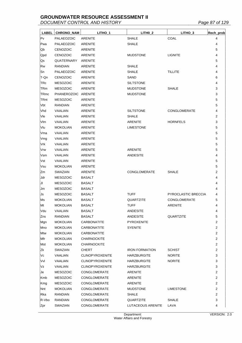
GROUNDWATER RESOURCE ASSESSMENT II DOCUMENT CONTROL AND HISTORY Page 87 of 129
Department: Water Affairs and Forestry
VERSION: 2.0
LABEL CHRONO_NAM LITHO_1 LITH0_2 LITHO_3 Rech_probPv PALAEOZOIC ARENITE SHALE COAL 4
Pwa PALAEOZOIC ARENITE SHALE 4
Qb CENOZOIC ARENITE 5
Qpd CENOZOIC ARENITE MUDSTONE LIGNITE 4
Qs QUATERNARY ARENITE 5
Rw RANDIAN ARENITE SHALE 4
Sn PALAEOZOIC ARENITE SHALE TILLITE 4
T-Qn CENOZOIC ARENITE SAND 6
TRc MESOZOIC ARENITE SILTSTONE 4
TRm MESOZOIC ARENITE MUDSTONE SHALE 3
TRmc PHANEROZOIC ARENITE MUDSTONE 3
TRnt MESOZOIC ARENITE 5
Vbt RANDIAN ARENITE 5
Vhd VAALIAN ARENITE SILTSTONE CONGLOMERATE 4
Vle VAALIAN ARENITE SHALE 2
Vlm VAALIAN ARENITE ARENITE HORNFELS 3
Vlu MOKOLIAN ARENITE LIMESTONE 5
Vma VAALIAN ARENITE 5
Vmg VAALIAN ARENITE 5
Vrk VAALIAN ARENITE 5
Vrw VAALIAN ARENITE ARENITE 5
Vsm VAALIAN ARENITE ANDESITE 4
Vst VAALIAN ARENITE 5
Vsu MOKOLIAN ARENITE 5
Zm SWAZIAN ARENITE CONGLOMERATE SHALE 2
Jdr MESOZOIC BASALT 4
Jl MESOZOIC BASALT 4
Jm MESOZOIC BASALT 4
Js MESOZOIC BASALT TUFF PYROCLASTIC BRECCIA 4
Ms MOKOLIAN BASALT QUARTZITE CONGLOMERATE 5
Mt MOKOLIAN BASALT TUFF ARENITE 4
Vdu VAALIAN BASALT ANDESITE 4
Zns RANDIAN BASALT ANDESITE QUARTZITE 5
Mgn MOKOLIAN CARBONATITE PYROXENITE 2
Mno MOKOLIAN CARBONATITE SYENITE 2
Mtw MOKOLIAN CARBONATITE 2
Mfr MOKOLIAN CHARNOCKITE 2
Mst MOKOLIAN CHARNOCKITE 2
Zk SWAZIAN CHERT IRON FORMATION SCHIST 2
Vc VAALIAN CLINOPYROXENITE HARZBURGITE NORITE 3
Vvl VAALIAN CLINOPYROXENITE HARZBURGITE NORITE 3
Vz VAALIAN CLINOPYROXENITE HARZBURGITE 3
Je MESOZOIC CONGLOMERATE ARENITE 2
Kmb MESOZOIC CONGLOMERATE ARENITE 2
Kmg MESOZOIC CONGLOMERATE ARENITE 2
Nnt MOKOLIAN CONGLOMERATE MUDSTONE LIMESTONE 2
Rka RANDIAN CONGLOMERATE SHALE 2
R-Vbo RANDIAN CONGLOMERATE QUARTZITE SHALE 3
Zpr SWAZIAN CONGLOMERATE LUTACEOUS ARENITE LAVA 4

GROUNDWATER RESOURCE ASSESSMENT II DOCUMENT CONTROL AND HISTORY Page 88 of 129
Department: Water Affairs and Forestry
VERSION: 2.0
LABEL CHRONO_NAM LITHO_1 LITH0_2 LITHO_3 Rech_probNnu NAMIBIAN DIAMICTITE DOLOMITE ARENITE 2
Vmk VAALIAN DIAMICTITE IRON FORMATION ARENITE 2
Rro RANDIAN DIORITE GABBRO 2
Jd MESOZOIC DOLERITE 6
Vdi MOKOLIAN DOLERITE 6
Vas VAALIAN DOLOMITE QUARTZITE 6
Vd VAALIAN DOLOMITE LIMESTONE SHALE 4
Vgh VAALIAN DOLOMITE LIMESTONE CHERT 4
Vm VAALIAN DOLOMITE CHERT 4
Vsc VAALIAN DOLOMITE SHALE 3
Vvo VAALIAN DOLOMITE IRON FORMATION LAVA 6
Mka MOKOLIAN DUNITE PYROXENITE NORITE 3
Z-Rm SWAZIAN DUNITE HARZBURGITE PYROXENITE 3
Mri MOKOLIAN GABBRO WEHRLITE GRANITE 4
Nma MOKOLIAN GABBRO NORITE 4
Nmb MOKOLIAN GABBRO NORITE PYROXENITE 4
Nti MOKOLIAN GABBRO 4
Rmd RANDIAN GABBRO NORITE PYROXENITE 4
Ru RANDIAN GABBRO GABBRO GRANITE 4
Vbi VAALIAN GABBRO 4
Vds VAALIAN GABBRO NORITE 4
Vmgr VAALIAN GABBRO NORITE 4
Vmn VAALIAN GABBRO 4
Vpy VAALIAN GABBRO NORITE 4
Vrs VAALIAN GABBRO DIORITE 4
Vvi VAALIAN GABBRO ANORTHOSITE 4
MB MOKOLIAN GNEISS GRANITE 3
Mbt MOKOLIAN GNEISS QUARTZITE SCHIST 3
Mga MOKOLIAN GNEISS 3
Mgl MOKOLIAN GNEISS 3
Mgo MOKOLIAN GNEISS QUARTZITE SCHIST 3
Mh MOKOLIAN GNEISS METAMORPHIC 3
Mho MOKOLIAN GNEISS 3
Mli MOKOLIAN GNEISS 3
Mva MOKOLIAN GNEISS 3
Nmp MOKOLIAN GNEISS GRANULITE 3
Nng MOKOLIAN GNEISS 3
Rbu RANDIAN GNEISS 3
Rdr RANDIAN GNEISS 3
Rho RANDIAN GNEISS MIGMATITE 3
Zb SWAZIAN GNEISS 3
ZC SWAZIAN GNEISS 3
ZD SWAZIAN GNEISS 3
Zgo SWAZIAN GNEISS GRANITE 3
Zhh SWAZIAN GNEISS MIGMATITE GRANODIORITE 3
Zma SWAZIAN GNEISS QUARTZITE PELITE 3
Zs SWAZIAN GNEISS 3
Mbi MOKOLIAN GRANITE 4
Mbk MOKOLIAN GRANITE 4

GROUNDWATER RESOURCE ASSESSMENT II DOCUMENT CONTROL AND HISTORY Page 89 of 129
Department: Water Affairs and Forestry
VERSION: 2.0
LABEL CHRONO_NAM LITHO_1 LITH0_2 LITHO_3 Rech_probMee MOKOLIAN GRANITE GNEISS 4
Mje MOKOLIAN GRANITE 4
Mke MOKOLIAN GRANITE 4
Mle VAALIAN GRANITE 4
Mnr MOKOLIAN GRANITE 4
Mpa MOKOLIAN GRANITE 4
Msc MOKOLIAN GRANITE 4
Msp MOKOLIAN GRANITE GNEISS 4
Mup MOKOLIAN GRANITE 4
Mwt MOKOLIAN GRANITE 4
N-Cma NAMIBIAN GRANITE 4
N-Cmak NAMIBIAN GRANITE 4
Nd MOKOLIAN GRANITE 4
Nl MOKOLIAN GRANITE 4
RB RANDIAN GRANITE 4
Rga VAALIAN GRANITE QUARTZ PORPHYRY 4
Rha VAALIAN GRANITE 4
Rsa SWAZIAN GRANITE 4
Rsk RANDIAN GRANITE 4
R-VA RANDIAN GRANITE 4
R-Vb VAALIAN GRANITE 4
R-Vh RANDIAN GRANITE 4
R-Vl RANDIAN GRANITE 4
R-Vm RANDIAN GRANITE 4
R-Vma RANDIAN GRANITE CHARNOCKITE 4
R-Vmh RANDIAN GRANITE 4
R-Vmo RANDIAN GRANITE 4
R-Vms RANDIAN GRANITE 4
R-Vmt VAALIAN GRANITE 4
R-Vp RANDIAN GRANITE 4
R-Vs VAALIAN GRANITE 4
R-Vsa VAALIAN GRANITE 4
R-Vsh VAALIAN GRANITE 4
R-Vt RANDIAN GRANITE 4
R-Vu VAALIAN GRANITE 4
VA VAALIAN GRANITE 4
VB VAALIAN GRANITE 4
Vme VAALIAN GRANITE 4
Vmpg RANDIAN GRANITE 4
Vra VAALIAN GRANITE 4
ZA SWAZIAN GRANITE GNEISS 4
ZB SWAZIAN GRANITE 4
Zka SWAZIAN GRANITE 4
Zne SWAZIAN GRANITE MIGMATITE 4
Mau MOKOLIAN GRANITOID 4
Mna MOKOLIAN GRANITOID 4
Mcn MOKOLIAN GRANODIORITE GRANITE QUARTZ MONZONITE 4
Mda MOKOLIAN GRANODIORITE 4
Mvi MOKOLIAN GRANODIORITE QUARTZ MONZONITE 4

GROUNDWATER RESOURCE ASSESSMENT II DOCUMENT CONTROL AND HISTORY Page 90 of 129
Department: Water Affairs and Forestry
VERSION: 2.0
LABEL CHRONO_NAM LITHO_1 LITH0_2 LITHO_3 Rech_probVC VAALIAN GRANODIORITE 4
Zda SWAZIAN GRANODIORITE 4
Zh SWAZIAN GRANODIORITE 4
Jt MESOZOIC GRANOPHYRE 3
Nbi NAMIBIAN GREENSTONE 2
Zn SWAZIAN GREENSTONE AMPHIBOLITE GRANULITE 2
Mlo MOKOLIAN HARZBURGITE NORITE GABBRO 3
Vho VAALIAN HORNFELS QUARTZITE LIMESTONE 4
Vn VAALIAN HORNFELS ARENITE ARENITE 4
Vve VAALIAN HORNFELS 4
R-Vhe RANDIAN IGNIMBRITE TUFF PYROCLASTIC 5
Va VAALIAN IRON FORMATION 2
Vla VAALIAN IRON FORMATION 2
Vp VAALIAN IRON FORMATION SHALE 2
Mgr MOKOLIAN KINZIGITE 2
Mto MOKOLIAN KINZIGITE 2
Md MOKOLIAN LAVA TUFF METAMORPHIC 5
Mk MOKOLIAN LAVA TUFF CONGLOMERATE 6
Mku MOKOLIAN LAVA PYROCLASTIC CARBONATITE 5
Mo MOKOLIAN LAVA GNEISS 4
Mpl MOKOLIAN LAVA TUFF 5
Vde VAALIAN LAVA TUFF SCHIST 4
Zg SWAZIAN LAVA SCHIST 4
Zgi SWAZIAN LAVA SCHIST 4
Zl SWAZIAN LAVA 5
Zmu SWAZIAN LAVA 5
Zo SWAZIAN LAVA PYROCLASTIC 6
Zp SWAZIAN LAVA QUARTZITE CONGLOMERATE 6
Zr SWAZIAN LAVA TUFF 5
Ki MESOZOIC LIMESTONE 6
Kmz MESOZOIC LIMESTONE CLAY 3
Nga NAMIBIAN LIMESTONE PHYLLITE RUDITE 3
Nsc NAMIBIAN LIMESTONE SHALE 3
T-Qa VAALIAN LIMESTONE CLAY CONGLOMERATE 3
T-Qb CENOZOIC LIMESTONE ARENITE CONGLOMERATE 4
Mm MOKOLIAN LUTACEOUS ARENITE QUARTZITE CONGLOMERATE 3
Nbr NAMIBIAN LUTACEOUS ARENITE 3
Nmo NAMIBIAN LUTACEOUS ARENITE SHALE LIMESTONE 3
Rt RANDIAN LUTACEOUS ARENITE CONGLOMERATE 3
Zf SWAZIAN LUTACEOUS ARENITE VOLCANIC ROCKS 3
Nmz MOKOLIAN MARBLE DOLOMITE GRANULITE 5
Zgu SWAZIAN MARBLE CALC-SILICATE ROCK GNEISS 5
Ml MOKOLIAN METAMORPHIC 4
Z SWAZIAN MIGMATITE GNEISS ULTRAMAFIC ROCKS 3
J-K MESOZOIC MUDSTONE ARENITE CONGLOMERATE 2
Pa PHANEROZOIC MUDSTONE ARENITE 2
Pem PALAEOZOIC MUDSTONE SHALE ARENITE 1
P-TRi PHANEROZOIC MUDSTONE ARENITE 2
TRb MESOZOIC MUDSTONE 2

GROUNDWATER RESOURCE ASSESSMENT II DOCUMENT CONTROL AND HISTORY Page 91 of 129
Department: Water Affairs and Forestry
VERSION: 2.0
LABEL CHRONO_NAM LITHO_1 LITH0_2 LITHO_3 Rech_probTRe MESOZOIC MUDSTONE ARENITE 2
TRny MESOZOIC MUDSTONE ARENITE 2
TRt MESOZOIC MUDSTONE ARENITE 2
Vk VAALIAN MUDSTONE IRON FORMATION 2
MA MOKOLIAN NORITE EPIDIORITE 3
Vdr VAALIAN NORITE PYROXENITE ANORTHOSITE 4
Vsl VAALIAN NORITE PYROXENITE ANORTHOSITE 4
Nhl MOKOLIAN OLIVINE GABBRO GABBRO 4
Ntr MOKOLIAN PERIDOTITE PYROXENITE GABBRO 4
Mz MOKOLIAN PHYLLITE QUARTZITE GREENSTONE 3
Nm NAMIBIAN PHYLLITE LUTACEOUS ARENITE CONGLOMERATE 3
Np NAMIBIAN PHYLLITE LUTACEOUS ARENITE LIMESTONE 3
Npo NAMIBIAN PHYLLITE LUTACEOUS ARENITE LIMESTONE 3
My MOKOLIAN PYROCLASTIC CARBONATITE 7
Jp JURASSIC PYROCLASTIC BRECCIA TUFF 7
Ksu PHANEROZOIC PYROCLASTIC BRECCIA TUFF TRACHYTOID 7
Mkk MOKOLIAN PYROXENITE SERPENTINITE 4
V-Mp MOKOLIAN PYROXENITE DUNITE CARBONATITE 4
Rmp RANDIAN QUARTZ MONZONITE 3
Rkr RANDIAN QUARTZ PORPHYRY RHYOLITE TRACHYTOID 5
Rm RANDIAN QUARTZ PORPHYRY 5
R-Va RANDIAN QUARTZ PORPHYRY TUFF 5
R-Vr RANDIAN QUARTZ PORPHYRY 5
Vgl VAALIAN QUARTZ PORPHYRY CONGLOMERATE ARENITE 5
Mbr MOKOLIAN QUARTZITE SHALE ARENITE 3
Mge MOKOLIAN QUARTZITE CALC-SILICATE ROCK 7
Mkh MOKOLIAN QUARTZITE SCHIST 5
Mko MOKOLIAN QUARTZITE CONGLOMERATE 6
Mr MOKOLIAN QUARTZITE 6
Mu MOKOLIAN QUARTZITE SCHIST 5
Nka NAMIBIAN QUARTZITE PHYLLITE SCHIST 5
Nku NAMIBIAN QUARTZITE 6
Ns NAMIBIAN QUARTZITE ARENITE DOLOMITE 7
Rg RANDIAN QUARTZITE SHALE 3
Rjo RANDIAN QUARTZITE CONGLOMERATE SHALE 4
Rmz RANDIAN QUARTZITE SHALE HORNFELS 4
Vbr VAALIAN QUARTZITE CONGLOMERATE SHALE 4
Vda VAALIAN QUARTZITE 6
Vdw VAALIAN QUARTZITE SILTSTONE CONGLOMERATE 4
Vg VAALIAN QUARTZITE SHALE LAVA 3
Vl VAALIAN QUARTZITE ARENITE 5
Zmo SWAZIAN QUARTZITE GNEISS 5
Zw SWAZIAN QUARTZITE CONGLOMERATE SCHIST 4
Jb PHANEROZOIC RHYOLITE SYENITE BASALT 3
Jj MESOZOIC RHYOLITE 3
Vdm VAALIAN RHYOLITE PYROCLASTIC 3
Vkw VAALIAN RHYOLITE 3
Vro VAALIAN RHYOLITE 3
Vse VAALIAN RHYOLITE 3

GROUNDWATER RESOURCE ASSESSMENT II DOCUMENT CONTROL AND HISTORY Page 92 of 129
Department: Water Affairs and Forestry
VERSION: 2.0
LABEL CHRONO_NAM LITHO_1 LITH0_2 LITHO_3 Rech_probVsh VAALIAN RHYOLITE 3
Mss MOKOLIAN RUDITE CONGLOMERATE ARENITE 3
Qm CENOZOIC SAND 10
T-Qk CENOZOIC SAND LIMESTONE 9
Mb MOKOLIAN SCHIST CONGLOMERATE QUARTZITE 2
Me MOKOLIAN SCHIST GNEISS QUARTZITE 2
Mg MOKOLIAN SCHIST QUARTZITE LAVA 2
Msr SCHIST GNEISS KINZIGITE 3
Nbe NAMIBIAN SCHIST LUTACEOUS ARENITE LIMESTONE 3
Ng NAMIBIAN SCHIST ANDESITE BASALT 3
Ngi NAMIBIAN SCHIST LIMESTONE DOLOMITE 3
Nho NAMIBIAN SCHIST GNEISS ARENITE 3
Nkl NAMIBIAN SCHIST 2
Nmf MOKOLIAN SCHIST 2
No NAMIBIAN SCHIST PHYLLITE DOLOMITE 3
Npr NAMIBIAN SCHIST PHYLLITE 3
Vdg MOKOLIAN SCHIST QUARTZITE AMPHIBOLITE 4
Nv NAMIBIAN SEDIMENTARY 5
Q QUATERNARY SEDIMENTARY SAND CALCRETE 7
Nml MOKOLIAN SERPENTINITE GABBRO 2
Nsi MOKOLIAN SERPENTINITE 2
Db PALAEOZOIC SHALE 1
Dbi PALAEOZOIC SHALE SILTSTONE ARENITE 1
Dc PALAEOZOIC SHALE ARENITE 2
Dl PALAEOZOIC SHALE ARENITE DIAMICTITE 2
Dt PALAEOZOIC SHALE SILTSTONE ARENITE 1
Nkn NAMIBIAN SHALE SILTSTONE ARENITE 1
Nt NAMIBIAN SHALE LUTACEOUS ARENITE QUARTZITE 1
Pe PALAEOZOIC SHALE 1
Pf PALAEOZOIC SHALE 1
Pk PALAEOZOIC SHALE 1
Pp PALAEOZOIC SHALE 1
Ppr PALAEOZOIC SHALE 1
Ppw PALAEOZOIC SHALE 1
Ps PALAEOZOIC SHALE ARENITE 2
Pt PALAEOZOIC SHALE 1
P-TR PHANEROZOIC SHALE ARENITE MUDSTONE 1
P-TRsk MESOZOIC SHALE MUDSTONE ARENITE 1
Pvo PALAEOZOIC SHALE 1
Pw PALAEOZOIC SHALE 1
Rh RANDIAN SHALE QUARTZITE 2
Rj RANDIAN SHALE QUARTZITE LAVA 2
Vga VAALIAN SHALE QUARTZITE CONGLOMERATE 2
Vlo VAALIAN SHALE ARENITE CONGLOMERATE 2
Vmt VAALIAN SHALE 1
Vrt VAALIAN SHALE ARENITE 2
Vry VAALIAN SHALE ARENITE 2
Vs VAALIAN SHALE 1
Vsi VAALIAN SHALE 1

GROUNDWATER RESOURCE ASSESSMENT II DOCUMENT CONTROL AND HISTORY Page 93 of 129
Department: Water Affairs and Forestry
VERSION: 2.0
LABEL CHRONO_NAM LITHO_1 LITH0_2 LITHO_3 Rech_probVt VAALIAN SHALE ARENITE 2
Vw VAALIAN SHALE ARENITE CONGLOMERATE 2
Tg CENOZOIC SILCRETE 1
Vvs VAALIAN SILICICLASTIC 1
Kz MESOZOIC SILTSTONE ARENITE CONGLOMERATE 2
Tu CENOZOIC SILTSTONE LIMESTONE LIMESTONE 3
Vv VAALIAN SILTSTONE SHALE ARENITE 2
Vbl VAALIAN SLATE ANDESITE QUARTZITE 2
Mpi MOKOLIAN SYENITE ALKALI-FELDSPAR SYENITE ANDESITE 5
Mps MOKOLIAN SYENITE 5
Msi MOKOLIAN SYENITE ALKALI-FELDSPAR SYENITE CARBONATITE 6
Nke NAMIBIAN SYENITE GRANITE 5
Nr NAMIBIAN SYENITE GRANITE 5
Rbo SWAZIAN SYENITE 5
VD VAALIAN SYENITE 5
Vmd VAALIAN SYENITE 5
Vsa RANDIAN SYENITE GRANITE 5
C-Pd PALAEOZOIC TILLITE ARENITE MUDSTONE 2
Nko MOKOLIAN TONALITE 4
Rc RANDIAN TONALITE 4
Ra RANDIAN TUFF 7
R-Vha RANDIAN TUFF ANDESITE CHERT 7
Vvg RANDIAN TUFF PYROCLASTIC BRECCIA 9
Z-R ARCHAEAN ULTRAMAFIC ROCKS 3
Mw MOKOLIAN VOLCANIC ROCKS 5
R-Vso RANDIAN VOLCANIC ROCKS 5
Vb VAALIAN VOLCANIC ROCKS ARENITE 5

GROUNDWATER RESOURCE ASSESSMENT II DOCUMENT CONTROL AND HISTORY Page 94 of 129
Department: Water Affairs and Forestry
VERSION: 2.0
A.2: Recharge values from literature

GROUNDWATER RESOURCE ASSESSMENT II DOCUMENT CONTROL AND HISTORY Page 95 of 129
Department: Water Affairs and Forestry
VERSION: 2.0

GROUNDWATER RESOURCE ASSESSMENT II DOCUMENT CONTROL AND HISTORY Page 96 of 129
Department: Water Affairs and Forestry
VERSION: 2.0

GROUNDWATER RESOURCE ASSESSMENT II DOCUMENT CONTROL AND HISTORY Page 97 of 129
Department: Water Affairs and Forestry
VERSION: 2.0

GROUNDWATER RESOURCE ASSESSMENT II DOCUMENT CONTROL AND HISTORY Page 98 of 129
Department: Water Affairs and Forestry
VERSION: 2.0

GROUNDWATER RESOURCE ASSESSMENT II DOCUMENT CONTROL AND HISTORY Page 99 of 129
Department: Water Affairs and Forestry
VERSION: 2.0
A.3: Recharge summaries per quaternary catchment
GIS-calibrated recharge Theoretical values per catchment Adjusted in grid QUAT Area MAP Recharge Recharge Volume Baseflow Adjust Adj. Adj. Adj. Adj. Adj. Rech Adj. Vol.
km2 mm % mm/a Mm3 Mm3 recharge recharge recharge rech % calc. calc. from grid calc. calc. GW/SW 1=true Mm3 mm/a % from grid mm/a Mm3
A10A 559 558 3.9511 22.0471 12.3244 0.04984 0 12.3244 22.0471 3.9511 3.9606 22.1001 12.3540A10B 1015 529 3.2668 17.2814 17.5406 0.07140 0 17.5406 17.2814 3.2668 3.2697 17.2967 17.5562A10C 271 537 3.5107 18.8525 5.1090 0.02018 0 5.1090 18.8525 3.5107 3.5000 18.7950 5.0934A21A 482 684 8.0136 54.8130 26.4199 9.77144 0 26.4199 54.8130 8.0136 7.9961 54.6933 26.3622A21B 527 672 7.0410 47.3155 24.9353 5.34943 0 24.9353 47.3155 7.0410 7.0382 47.2967 24.9254A21C 761 682 6.0972 41.5829 31.6446 21.34628 0 31.6446 41.5829 6.0972 6.0930 41.5543 31.6228A21D 372 714 7.2362 51.6665 19.2199 15.21834 0 19.2199 51.6665 7.2362 7.2745 51.9399 19.3217A21E 290 707 6.0888 43.0478 12.4839 8.79785 0 12.4839 43.0478 6.0888 6.0897 43.0542 12.4857A21F 1001 677 6.9543 47.0806 47.1277 10.95699 0 47.1277 47.0806 6.9543 6.9965 47.3663 47.4137A21G 160 694 5.5752 38.6919 6.1907 10.45586 1 10.4559 65.3491 9.4163 9.4410 65.5205 10.4833A21H 514 668 6.0877 40.6658 20.9022 4.42240 0 20.9022 40.6658 6.0877 6.1182 40.8696 21.0070A21J 1151 637 4.0834 26.0113 29.9390 4.81209 0 29.9390 26.0113 4.0834 4.1370 26.3527 30.3319A21K 865 651 4.1377 26.9364 23.3000 16.35287 0 23.3000 26.9364 4.1377 4.1093 26.7515 23.1401A21L 213 589 1.8676 11.0002 2.3430 0.65900 0 2.3430 11.0002 1.8676 1.9142 11.2746 2.4015A22A 707 604 5.6384 34.0559 24.0775 4.40199 0 24.0775 34.0559 5.6384 5.6396 34.0632 24.0827A22B 284 599 6.2668 37.5381 10.6608 1.71772 0 10.6608 37.5381 6.2668 6.2828 37.6340 10.6880A22C 515 611 4.5992 28.1011 14.4721 2.72305 0 14.4721 28.1011 4.5992 4.6384 28.3406 14.5954A22D 542 582 4.0240 23.4197 12.6935 1.83982 0 12.6935 23.4197 4.0240 4.0117 23.3481 12.6547A22E 813 597 4.4626 26.6417 21.6597 2.97901 0 21.6597 26.6417 4.4626 4.4679 26.6734 21.6854A22F 1690 604 2.6107 15.7686 26.6490 6.14018 0 26.6490 15.7686 2.6107 2.6086 15.7559 26.6275A22G 499 656 4.9186 32.2660 16.1007 3.56810 0 16.1007 32.2660 4.9186 4.9368 32.3854 16.1603A22H 579 658 4.0960 26.9517 15.6050 2.88783 0 15.6050 26.9517 4.0960 4.1148 27.0754 15.6766A22J 592 600 2.5150 15.0900 8.9333 2.19849 0 8.9333 15.0900 2.5150 2.5370 15.2220 9.0114A23A 682 698 8.0071 55.8896 38.1167 15.96966 0 38.1167 55.8896 8.0071 8.1140 56.6357 38.6256A23B 814 645 3.8235 24.6616 20.0745 6.45162 0 20.0745 24.6616 3.8235 3.7987 24.5016 19.9443A23C 491 574 1.6626 9.5433 4.6858 1.46104 0 4.6858 9.5433 1.6626 1.6494 9.4676 4.6486A23D 145 706 6.0187 42.4920 6.1613 12.22132 1 12.2213 84.2850 11.9384 12.0150 84.8259 12.2998A23E 490 674 3.7617 25.3539 12.4234 4.25274 0 12.4234 25.3539 3.7617 3.8125 25.6963 12.5912A23F 565 596 1.9246 11.4706 6.4809 1.84681 0 6.4809 11.4706 1.9246 1.9561 11.6584 6.5870A23G 952 591 3.6602 21.6318 20.5935 5.57606 0 20.5935 21.6318 3.6602 3.6266 21.4332 20.4044A23H 1058 600 2.8866 17.3196 18.3241 3.80509 0 18.3241 17.3196 2.8866 2.8640 17.1840 18.1807A23J 931 585 1.2454 7.2856 6.7829 3.01546 0 6.7829 7.2856 1.2454 1.2404 7.2563 6.7557A23K 1131 606 1.7230 10.4414 11.8092 3.90437 0 11.8092 10.4414 1.7230 1.7583 10.6553 12.0511A23L 329 604 1.5477 9.3481 3.0755 1.12451 0 3.0755 9.3481 1.5477 1.5115 9.1295 3.0036A24A 493 599 1.8873 11.3049 5.5733 1.66573 0 5.5733 11.3049 1.8873 1.8711 11.2079 5.5255A24B 709 617 3.0797 19.0017 13.4722 2.62904 0 13.4722 19.0017 3.0797 3.0559 18.8549 13.3681A24C 802 589 2.5377 14.9471 11.9875 0.07637 0 11.9875 14.9471 2.5377 2.5589 15.0719 12.0877A24D 1328 600 2.5811 15.4866 20.5662 0.15255 0 20.5662 15.4866 2.5811 2.5773 15.4638 20.5359A24E 688 592 1.4442 8.5497 5.8822 0.07707 0 5.8822 8.5497 1.4442 1.4364 8.5035 5.8504A24F 591 602 2.9518 17.7698 10.5020 0.07213 0 10.5020 17.7698 2.9518 2.8948 17.4267 10.2992A24G 736 645 4.0709 26.2573 19.3254 8.30767 0 19.3254 26.2573 4.0709 4.0480 26.1096 19.2167A24H 1339 639 4.3629 27.8789 37.3299 8.72510 0 37.3299 27.8789 4.3629 4.3578 27.8463 37.2863A24J 2518 538 2.5652 13.8008 34.7504 0.14305 0 34.7504 13.8008 2.5652 2.5902 13.9353 35.0890A31A 633 602 4.4373 26.7125 16.9090 7.47963 0 16.9090 26.7125 4.4373 4.4287 26.6608 16.8763A31B 597 607 4.4040 26.7323 15.9592 7.17964 0 15.9592 26.7323 4.4040 4.3888 26.6400 15.9041A31C 486 546 5.6818 31.0226 15.0770 1.35322 0 15.0770 31.0226 5.6818 5.7501 31.3955 15.2582A31D 705 566 5.2470 29.6980 20.9371 2.11499 0 20.9371 29.6980 5.2470 5.2820 29.8961 21.0768A31E 602 597 4.8343 28.8608 17.3742 3.30927 0 17.3742 28.8608 4.8343 4.8369 28.8763 17.3835A31F 703 591 5.0063 29.5872 20.7998 3.12523 0 20.7998 29.5872 5.0063 5.0339 29.7503 20.9145A31G 1427 583 4.5003 26.2367 37.4398 6.32613 0 37.4398 26.2367 4.5003 4.5116 26.3026 37.5339A31H 685 579 3.8656 22.3818 15.3315 0.00000 0 15.3315 22.3818 3.8656 3.8657 22.3824 15.3319A31J 846 552 3.9745 21.9392 18.5606 0.00000 0 18.5606 21.9392 3.9745 4.0002 22.0811 18.6806A32A 473 547 3.0941 16.9247 8.0054 0.00000 0 8.0054 16.9247 3.0941 3.1131 17.0287 8.0546A32B 642 569 2.3149 13.1718 8.4563 0.00000 0 8.4563 13.1718 2.3149 2.2978 13.0745 8.3938A32C 904 526 3.3995 17.8814 16.1648 0.00000 0 16.1648 17.8814 3.3995 3.4076 17.9240 16.2033A32D 844 533 3.0862 16.4494 13.8833 0.00000 0 13.8833 16.4494 3.0862 3.0884 16.4612 13.8932A32E 2502 526 2.3559 12.3920 31.0049 0.00000 0 31.0049 12.3920 2.3559 2.3611 12.4194 31.0733A41A 692 625 4.4097 27.5606 19.0720 7.04881 0 19.0720 27.5606 4.4097 4.4346 27.7163 19.1796A41B 358 587 4.0612 23.8392 8.5344 2.98851 0 8.5344 23.8392 4.0612 4.1053 24.0981 8.6271A41C 1111 512 2.8693 14.6908 16.3215 0.00000 0 16.3215 14.6908 2.8693 2.8705 14.6970 16.3283A41D 1913 492 2.1827 10.7389 20.5435 0.00000 0 20.5435 10.7389 2.1827 2.1776 10.7138 20.4955A41E 1940 438 1.7211 7.5384 14.6245 0.00000 0 14.6245 7.5384 1.7211 1.7306 7.5800 14.7053A42A 573 640 4.3764 28.0090 16.0491 15.65102 0 16.0491 28.0090 4.3764 4.3803 28.0339 16.0634A42B 522 660 4.8836 32.2318 16.8250 15.43591 0 16.8250 32.2318 4.8836 4.8552 32.0443 16.7271A42C 698 656 4.7515 31.1698 21.7565 20.31357 0 21.7565 31.1698 4.7515 4.7637 31.2499 21.8124A42D 497 667 5.2286 34.8748 17.3328 19.06608 1 19.0661 38.3623 5.7515 5.7879 38.6053 19.1868A42E 1007 605 3.6863 22.3021 22.4582 30.12014 1 30.1201 29.9108 4.9439 4.9076 29.6910 29.8988A42F 1022 577 3.7692 21.7483 22.2267 9.78202 0 22.2267 21.7483 3.7692 3.8100 21.9837 22.4673A42G 1207 551 3.8027 20.9529 25.2901 10.41838 0 25.2901 20.9529 3.8027 3.8365 21.1391 25.5149A42H 1057 518 2.8522 14.7744 15.6165 7.23208 0 15.6165 14.7744 2.8522 2.8730 14.8821 15.7304

GROUNDWATER RESOURCE ASSESSMENT II DOCUMENT CONTROL AND HISTORY Page 100 of 129
Department: Water Affairs and Forestry
VERSION: 2.0
A42J 1812 428 1.6939 7.2499 13.1368 0.00000 0 13.1368 7.2499 1.6939 1.7116 7.3256 13.2741A50A 298 654 5.2467 34.3134 10.2254 11.28222 1 11.2822 37.8598 5.7890 5.7985 37.9222 11.3008A50B 406 599 4.2318 25.3485 10.2915 11.85623 1 11.8562 29.2025 4.8752 4.8983 29.3408 11.9124A50C 362 593 3.9050 23.1567 8.3827 10.31520 1 10.3152 28.4950 4.8052 4.8298 28.6407 10.3679A50D 637 558 3.5500 19.8090 12.6183 6.33399 0 12.6183 19.8090 3.5500 3.5544 19.8336 12.6340A50E 629 517 3.3137 17.1318 10.7759 4.64450 0 10.7759 17.1318 3.3137 3.3389 17.2621 10.8579A50F 372 496 2.8736 14.2531 5.3021 2.29195 0 5.3021 14.2531 2.8736 2.8975 14.3716 5.3462A50G 821 435 2.5728 11.1917 9.1884 0.00000 0 9.1884 11.1917 2.5728 2.5732 11.1934 9.1898A50H 1945 407 1.9031 7.7456 15.0652 0.00000 0 15.0652 7.7456 1.9031 1.9080 7.7656 15.1040A50J 1255 391 1.8113 7.0822 8.8881 0.00000 0 8.8881 7.0822 1.8113 1.8053 7.0587 8.8587A61A 381 629 4.9220 30.9594 11.7955 7.05616 0 11.7955 30.9594 4.9220 4.9450 31.1041 11.8506A61B 362 618 4.8201 29.7882 10.7833 5.73038 0 10.7833 29.7882 4.8201 4.8099 29.7252 10.7605A61C 587 608 4.6372 28.1942 16.5500 6.64657 0 16.5500 28.1942 4.6372 4.6104 28.0312 16.4543A61D 456 612 4.4402 27.1740 12.3914 6.23001 0 12.3914 27.1740 4.4402 4.4608 27.3001 12.4488A61E 547 593 3.2547 19.3004 10.5573 6.06915 0 10.5573 19.3004 3.2547 3.2412 19.2203 10.5135A61F 789 597 4.6747 27.9080 22.0194 6.54681 0 22.0194 27.9080 4.6747 4.6946 28.0268 22.1131A61G 927 585 3.7805 22.1159 20.5015 7.17892 0 20.5015 22.1159 3.7805 3.8279 22.3932 20.7585A61H 585 636 5.0573 32.1644 18.8162 11.71043 0 18.8162 32.1644 5.0573 5.0557 32.1543 18.8102A61J 818 631 4.5488 28.7029 23.4790 15.86843 0 23.4790 28.7029 4.5488 4.5320 28.5969 23.3923A62A 428 610 4.2390 25.8579 11.0672 8.19453 0 11.0672 25.8579 4.2390 4.2505 25.9281 11.0972A62B 710 529 3.7600 19.8904 14.1222 4.51694 0 14.1222 19.8904 3.7600 3.7552 19.8650 14.1042A62C 385 478 3.5026 16.7424 6.4458 1.74223 0 6.4458 16.7424 3.5026 3.5042 16.7501 6.4488A62D 603 489 3.4206 16.7267 10.0862 2.92805 0 10.0862 16.7267 3.4206 3.4413 16.8280 10.1473A62E 621 460 2.9950 13.7770 8.5555 0.00000 0 8.5555 13.7770 2.9950 2.9944 13.7742 8.5538A62F 620 478 3.0600 14.6268 9.0686 0.00000 0 9.0686 14.6268 3.0600 3.0571 14.6129 9.0600A62G 627 437 2.9981 13.1017 8.2148 0.00000 0 8.2148 13.1017 2.9981 3.0112 13.1589 8.2507A62H 871 439 2.8205 12.3820 10.7847 0.00000 0 10.7847 12.3820 2.8205 2.8179 12.3706 10.7748A62J 930 450 2.9591 13.3160 12.3838 0.00000 0 12.3838 13.3160 2.9591 2.9580 13.3110 12.3792A63A 1928 433 2.1152 9.1588 17.6582 0.00000 0 17.6582 9.1588 2.1152 2.1353 9.2458 17.8260A63B 1505 394 1.8599 7.3280 11.0286 0.00000 0 11.0286 7.3280 1.8599 1.8844 7.4245 11.1739A63C 1323 378 1.6406 6.2015 8.2045 0.00000 0 8.2045 6.2015 1.6406 1.6328 6.1720 8.1655A63D 1319 412 2.4737 10.1916 13.4428 0.00000 0 13.4428 10.1916 2.4737 2.4992 10.2967 13.5814A63E 1992 358 1.9291 6.9062 13.7571 0.00000 0 13.7571 6.9062 1.9291 1.9172 6.8636 13.6722A71A 1144 468 2.9696 13.8977 15.8990 0.00000 0 15.8990 13.8977 2.9696 3.0155 14.1125 16.1447A71B 882 450 2.3325 10.4963 9.2577 0.00000 0 9.2577 10.4963 2.3325 2.3620 10.6290 9.3748A71C 1331 418 1.7143 7.1658 9.5376 0.00000 0 9.5376 7.1658 1.7143 1.7431 7.2862 9.6979A71D 892 390 0.6925 2.7008 2.4091 0.00000 0 2.4091 2.7008 0.6925 0.6842 2.6684 2.3802A71E 893 421 1.6573 6.9772 6.2307 0.00000 0 6.2307 6.9772 1.6573 1.6550 6.9676 6.2220A71F 683 400 1.4739 5.8956 4.0267 0.00000 0 4.0267 5.8956 1.4739 1.4901 5.9604 4.0710A71G 875 427 1.1782 5.0309 4.4020 0.00000 0 4.4020 5.0309 1.1782 1.1402 4.8687 4.2601A71H 1012 491 2.8672 14.0780 14.2469 0.00000 0 14.2469 14.0780 2.8672 2.8131 13.8123 13.9781A71J 1162 396 2.5152 9.9602 11.5737 0.00000 0 11.5737 9.9602 2.5152 2.5811 10.2212 11.8770A71K 1668 305 1.8624 5.6803 9.4748 0.00000 0 9.4748 5.6803 1.8624 1.8566 5.6626 9.4453A71L 1765 288 1.9000 5.4720 9.6581 0.00000 0 9.6581 5.4720 1.9000 1.8948 5.4570 9.6316A72A 1908 465 2.1393 9.9477 18.9803 0.00000 0 18.9803 9.9477 2.1393 2.1084 9.8041 18.7061A72B 1554 344 1.6353 5.6254 8.7419 0.00000 0 8.7419 5.6254 1.6353 1.6491 5.6729 8.8157A80A 287 938 9.8289 92.1951 26.4600 15.41551 0 26.4600 92.1951 9.8289 9.9089 92.9455 26.6754A80B 251 659 7.0892 46.7178 11.7262 4.55310 0 11.7262 46.7178 7.0892 7.1718 47.2622 11.8628A80C 294 576 6.2927 36.2460 10.6563 3.22811 0 10.6563 36.2460 6.2927 6.4651 37.2390 10.9483A80D 128 622 5.9083 36.7496 4.7040 2.01007 0 4.7040 36.7496 5.9083 5.8985 36.6887 4.6961A80E 247 622 6.3383 39.4242 9.7378 3.88780 0 9.7378 39.4242 6.3383 6.4460 40.0941 9.9032A80F 630 388 3.0122 11.6873 7.3630 0.00000 0 7.3630 11.6873 3.0122 3.1774 12.3283 7.7668A80G 1230 333 2.5161 8.3786 10.3057 0.00000 0 10.3057 8.3786 2.5161 2.5532 8.5022 10.4577A80H 266 621 6.1384 38.1195 10.1398 8.94097 0 10.1398 38.1195 6.1384 6.3037 39.1460 10.4128A80J 870 292 1.5992 4.6697 4.0626 0.00000 0 4.0626 4.6697 1.5992 1.6138 4.7123 4.0997A91A 232 696 6.2792 43.7032 10.1391 8.75533 0 10.1391 43.7032 6.2792 6.2203 43.2933 10.0440A91B 275 620 4.6457 28.8033 7.9209 6.95153 0 7.9209 28.8033 4.6457 4.6668 28.9342 7.9569A91C 250 866 6.5245 56.5022 14.1255 19.90127 1 19.9013 79.6051 9.1923 9.0477 78.3531 19.5883A91D 132 1287 8.4832 109.1788 14.4116 23.33388 1 23.3339 176.7718 13.7352 13.5318 174.1543 22.9884A91E 223 1078 7.9446 85.6428 19.0983 28.96124 1 28.9612 129.8710 12.0474 11.7188 126.3287 28.1713A91F 580 662 4.2120 27.8834 16.1724 6.57033 0 16.1724 27.8834 4.2120 4.1140 27.2347 15.7961A91G 406 950 8.1552 77.4744 31.4546 70.37214 1 70.3721 173.3304 18.2453 18.0416 171.3952 69.5865A91H 450 722 5.3679 38.7562 17.4403 7.67278 0 17.4403 38.7562 5.3679 5.2833 38.1454 17.1654A91J 570 450 2.6873 12.0929 6.8929 0.00000 0 6.8929 12.0929 2.6873 2.7364 12.3138 7.0189A91K 669 373 1.4476 5.3995 3.6123 0.00000 0 3.6123 5.3995 1.4476 1.4651 5.4648 3.6560A92A 329 997 9.1501 91.2265 30.0135 60.53760 1 60.5376 184.0049 18.4559 18.5862 185.3044 60.9652A92B 565 711 6.7291 47.8439 27.0318 8.69646 0 27.0318 47.8439 6.7291 6.9870 49.6776 28.0678A92C 455 423 2.9495 12.4764 5.6768 0.00000 0 5.6768 12.4764 2.9495 3.0845 13.0474 5.9366A92D 805 301 1.0126 3.0479 2.4536 0.00000 0 2.4536 3.0479 1.0126 1.0157 3.0573 2.4611B11A 945 699 6.0087 42.0008 39.6908 13.53867 0 39.6908 42.0008 6.0087 5.9706 41.7345 39.4391B11B 435 687 7.4401 51.1135 22.2344 5.91109 0 22.2344 51.1135 7.4401 7.4199 50.9747 22.1740B11C 385 673 5.1510 34.6662 13.3465 4.91358 0 13.3465 34.6662 5.1510 5.1052 34.3580 13.2278B11D 551 671 5.8210 39.0589 21.5215 6.48364 0 21.5215 39.0589 5.8210 5.7863 38.8261 21.3932B11E 467 682 6.5849 44.9090 20.9725 5.76125 0 20.9725 44.9090 6.5849 6.5794 44.8715 20.9550B11F 428 692 6.8493 47.3972 20.2860 5.52034 0 20.2860 47.3972 6.8493 6.8508 47.4075 20.2904B11G 368 693 7.3914 51.2224 18.8498 4.81131 0 18.8498 51.2224 7.3914 7.4056 51.3208 18.8861B11H 246 695 7.7403 53.7951 13.2336 3.24917 0 13.2336 53.7951 7.7403 7.7756 54.0404 13.2939

GROUNDWATER RESOURCE ASSESSMENT II DOCUMENT CONTROL AND HISTORY Page 101 of 129
Department: Water Affairs and Forestry
VERSION: 2.0
B11J 269 682 6.7769 46.2185 12.4328 6.88447 0 12.4328 46.2185 6.7769 6.7769 46.2185 12.4328B11K 378 684 6.6104 45.2151 17.0913 9.23407 0 17.0913 45.2151 6.6104 6.6090 45.2056 17.0877B11L 242 692 6.9031 47.7695 11.5602 6.06481 0 11.5602 47.7695 6.9031 6.8944 47.7092 11.5456B12A 405 672 6.8959 46.3404 18.7679 4.24618 0 18.7679 46.3404 6.8959 6.8504 46.0347 18.6440B12B 659 697 7.9199 55.2017 36.3779 7.76016 0 36.3779 55.2017 7.9199 7.9015 55.0735 36.2934B12C 529 707 7.8679 55.6261 29.4262 6.47678 0 29.4262 55.6261 7.8679 7.8804 55.7144 29.4729B12D 362 703 7.5778 53.2719 19.2844 4.65888 0 19.2844 53.2719 7.5778 7.5981 53.4146 19.3361B12E 436 697 6.7572 47.0977 20.5346 11.45358 0 20.5346 47.0977 6.7572 6.7814 47.2664 20.6081B20A 574 661 6.6316 43.8349 25.1612 9.87655 0 25.1612 43.8349 6.6316 6.5393 43.2248 24.8110B20B 322 667 9.5732 63.8532 20.5607 5.35500 0 20.5607 63.8532 9.5732 9.3760 62.5379 20.1372B20C 364 675 12.8434 86.6930 31.5562 6.25984 0 31.5562 86.6930 12.8434 12.7774 86.2475 31.3941B20D 480 677 11.0384 74.7300 35.8704 7.84912 0 35.8704 74.7300 11.0384 11.1099 75.2140 36.1027B20E 620 657 6.3427 41.6715 25.8364 10.03887 0 25.8364 41.6715 6.3427 6.2892 41.3200 25.6184B20F 504 667 8.8330 58.9161 29.6937 8.00471 0 29.6937 58.9161 8.8330 8.8057 58.7340 29.6019B20G 522 669 6.9717 46.6407 24.3464 12.28498 0 24.3464 46.6407 6.9717 6.9673 46.6112 24.3311B20H 563 671 6.5768 44.1303 24.8454 12.64823 0 24.8454 44.1303 6.5768 6.6182 44.4081 25.0018B20J 407 696 6.3076 43.9009 17.8677 9.47056 0 17.8677 43.9009 6.3076 6.3491 44.1897 17.9852B31A 387 677 8.1205 54.9758 21.2756 5.07964 0 21.2756 54.9758 8.1205 8.2316 55.7279 21.5667B31B 385 640 4.9022 31.3741 12.0790 3.94979 0 12.0790 31.3741 4.9022 4.9490 31.6736 12.1943B31C 373 607 2.6428 16.0418 5.9836 3.31489 0 5.9836 16.0418 2.6428 2.6704 16.2093 6.0461B31D 558 599 3.4632 20.7446 11.5755 4.79544 0 11.5755 20.7446 3.4632 3.4914 20.9135 11.6697B31E 1382 588 3.4073 20.0349 27.6883 0.11055 0 27.6883 20.0349 3.4073 3.3776 19.8603 27.4469B31F 638 568 2.6424 15.0088 9.5756 0.04368 0 9.5756 15.0088 2.6424 2.6718 15.1758 9.6822B31G 433 604 4.2061 25.4048 11.0003 3.53734 0 11.0003 25.4048 4.2061 4.2725 25.8059 11.1740B31H 612 575 3.5494 20.4091 12.4903 4.17996 0 12.4903 20.4091 3.5494 3.6105 20.7604 12.7053B31J 1380 552 2.6319 14.5281 20.0488 0.08335 0 20.0488 14.5281 2.6319 2.6533 14.6462 20.2118B32A 801 691 6.5023 44.9309 35.9896 20.59227 0 35.9896 44.9309 6.5023 6.5217 45.0649 36.0970B32B 614 698 6.8008 47.4696 29.1463 14.50051 0 29.1463 47.4696 6.8008 6.8078 47.5184 29.1763B32C 303 664 6.2496 41.4973 12.5737 5.61486 0 12.5737 41.4973 6.2496 6.2876 41.7497 12.6501B32D 521 626 5.5122 34.5064 17.9778 3.44255 0 17.9778 34.5064 5.5122 5.5260 34.5928 18.0228B32E 203 668 6.3498 42.4167 8.6106 1.92011 0 8.6106 42.4167 6.3498 6.3706 42.5556 8.6388B32F 667 659 5.5630 36.6602 24.4523 5.52006 0 24.4523 36.6602 5.5630 5.5792 36.7669 24.5235B32G 968 639 5.2278 33.4056 32.3367 10.35391 0 32.3367 33.4056 5.2278 5.2426 33.5002 32.4282B32H 694 610 4.9444 30.1608 20.9316 6.36885 0 20.9316 30.1608 4.9444 4.9682 30.3060 21.0324B32J 323 589 4.7796 28.1518 9.0930 0.23053 0 9.0930 28.1518 4.7796 4.8235 28.4104 9.1766B41A 765 714 7.2665 51.8828 39.6903 19.38835 0 39.6903 51.8828 7.2665 7.2866 52.0263 39.8001B41B 778 705 6.7181 47.3626 36.8481 19.01611 0 36.8481 47.3626 6.7181 6.7260 47.4183 36.8914B41C 302 694 6.5792 45.6596 13.7892 7.25075 0 13.7892 45.6596 6.5792 6.6035 45.8283 13.8401B41D 403 652 5.9870 39.0352 15.7312 7.21855 0 15.7312 39.0352 5.9870 6.0041 39.1467 15.7761B41E 237 616 5.3807 33.1451 7.8554 0.17304 0 7.8554 33.1451 5.3807 5.4149 33.3558 7.9053B41F 380 676 7.0622 47.7405 18.1414 11.80743 0 18.1414 47.7405 7.0622 7.0759 47.8331 18.1766B41G 442 650 7.0634 45.9121 20.2931 12.47221 0 20.2931 45.9121 7.0634 7.1122 46.2293 20.4334B41H 410 621 5.5636 34.5500 14.1655 0.36530 0 14.1655 34.5500 5.5636 5.5890 34.7077 14.2302B41J 691 598 5.1312 30.6846 21.2030 0.73100 0 21.2030 30.6846 5.1312 5.1513 30.8048 21.2861B41K 635 626 5.1457 32.2121 20.4547 0.81595 0 20.4547 32.2121 5.1457 5.1010 31.9323 20.2770B42A 319 773 7.5761 58.5633 18.6817 19.72520 1 19.7252 61.8345 7.9993 8.0190 61.9869 19.7738B42B 214 879 8.5317 74.9936 16.0486 16.29780 1 16.2978 76.1580 8.6642 8.5191 74.8829 16.0249B42C 164 729 7.2217 52.6462 8.6340 2.65567 0 8.6340 52.6462 7.2217 7.2749 53.0340 8.6976B42D 155 1002 10.2439 102.6439 15.9098 15.88152 0 15.9098 102.6439 10.2439 10.2591 102.7962 15.9334B42E 222 645 6.6212 42.7067 9.4809 2.15628 0 9.4809 42.7067 6.6212 6.6329 42.7822 9.4976B42F 279 733 7.5230 55.1436 15.3851 15.37431 0 15.3851 55.1436 7.5230 7.5307 55.2000 15.4008B42G 327 676 7.4891 50.6263 16.5548 3.76900 0 16.5548 50.6263 7.4891 7.5055 50.7372 16.5911B42H 413 591 5.3581 31.6664 13.0782 0.36989 0 13.0782 31.6664 5.3581 5.3975 31.8992 13.1744B51A 311 616 4.0132 24.7213 7.6883 0.21306 0 7.6883 24.7213 4.0132 4.0470 24.9295 7.7531B51B 591 578 3.3968 19.6335 11.6034 0.40884 0 11.6034 19.6335 3.3968 3.4290 19.8196 11.7134B51C 638 529 3.5102 18.5690 11.8470 0.24911 0 11.8470 18.5690 3.5102 3.5280 18.6631 11.9071B51E 2927 542 2.3648 12.8172 37.5160 0.19724 0 37.5160 12.8172 2.3648 2.3548 12.7630 37.3573B51F 395 573 4.0185 23.0260 9.0953 0.23271 0 9.0953 23.0260 4.0185 3.9847 22.8323 9.0188B51G 591 528 2.3904 12.6213 7.4592 0.25859 0 7.4592 12.6213 2.3904 2.3444 12.3784 7.3157B51H 717 568 4.0299 22.8898 16.4120 0.36563 0 16.4120 22.8898 4.0299 4.0514 23.0120 16.4996B52A 566 475 2.0099 9.5470 5.4036 0.11478 0 5.4036 9.5470 2.0099 1.9608 9.3138 5.2716B52B 633 553 3.9702 21.9552 13.8976 0.43672 0 13.8976 21.9552 3.9702 3.9918 22.0747 13.9733B52C 200 539 4.0258 21.6991 4.3398 0.03181 0 4.3398 21.6991 4.0258 4.0425 21.7891 4.3578B52D 341 498 2.4616 12.2588 4.1802 0.03439 0 4.1802 12.2588 2.4616 2.4041 11.9724 4.0826B52E 451 535 3.4395 18.4013 8.2990 0.21492 0 8.2990 18.4013 3.4395 3.4266 18.3323 8.2679B52F 118 557 4.1251 22.9768 2.7113 0.02102 0 2.7113 22.9768 4.1251 4.1416 23.0687 2.7221B52G 291 518 3.6356 18.8324 5.4802 0.03995 0 5.4802 18.8324 3.6356 3.5953 18.6237 5.4195B52H 563 660 4.3267 28.5562 16.0772 0.80185 0 16.0772 28.5562 4.3267 4.3738 28.8671 16.2522B52J 395 570 4.5440 25.9008 10.2308 0.16610 0 10.2308 25.9008 4.5440 4.5230 25.7811 10.1835B60A 210 1193 9.5043 113.3863 23.8111 55.03404 1 55.0340 262.0669 21.9670 22.0187 262.6831 55.1634B60B 302 1026 8.1624 83.7462 25.2914 66.29903 1 66.2990 219.5332 21.3970 21.4748 220.3314 66.5401B60C 94 1352 8.2306 111.2777 10.4601 28.78594 1 28.7859 306.2334 22.6504 22.7323 307.3407 28.8900B60D 244 1004 7.3414 73.7077 17.9847 27.43920 1 27.4392 112.4557 11.2008 11.2430 112.8797 27.5427B60E 83 1027 10.2519 105.2870 8.7388 8.52881 0 8.7388 105.2870 10.2519 10.2899 105.6773 8.7712B60F 400 766 7.9911 61.2118 24.4847 7.11225 0 24.4847 61.2118 7.9911 8.0721 61.8323 24.7329B60G 448 681 6.4207 43.7250 19.5888 5.38703 0 19.5888 43.7250 6.4207 6.4602 43.9940 19.7093B60H 385 778 6.4081 49.8550 19.1942 6.94536 0 19.1942 49.8550 6.4081 6.3768 49.6115 19.1004
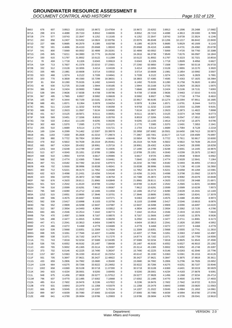
GROUNDWATER RESOURCE ASSESSMENT II DOCUMENT CONTROL AND HISTORY Page 102 of 129
Department: Water Affairs and Forestry
VERSION: 2.0
B60J 676 607 3.8913 23.6202 15.9672 13.47934 0 15.9672 23.6202 3.8913 4.1596 25.2488 17.0682B71A 298 674 4.4088 29.7153 8.8552 0.66006 0 8.8552 29.7153 4.4088 4.3813 29.5300 8.7999B71B 274 577 3.8743 22.3547 6.1252 0.13165 0 6.1252 22.3547 3.8743 3.8739 22.3524 6.1246B71C 263 858 6.2407 53.5452 14.0824 22.83756 1 22.8376 86.8348 10.1206 10.1217 86.8442 22.8400B71D 227 686 5.8685 40.2579 9.1385 8.83788 0 9.1385 40.2579 5.8685 5.8529 40.1509 9.1143B71E 782 591 4.4696 26.4153 20.6568 1.08243 0 20.6568 26.4153 4.4696 4.4731 26.4360 20.6730B71F 541 800 7.5069 60.0552 32.4899 29.33291 0 32.4899 60.0552 7.5069 7.4720 59.7760 32.3388B71G 245 845 7.6211 64.3983 15.7776 16.26158 1 16.2616 66.3738 7.8549 7.8176 66.0587 16.1844B71H 330 615 5.1797 31.8552 10.5122 0.11369 0 10.5122 31.8552 5.1797 5.3223 32.7321 10.8016B71J 78 459 1.7718 8.1326 0.6343 0.00619 0 0.6343 8.1326 1.7718 1.8509 8.4956 0.6627B72A 534 713 5.7837 41.2378 22.0210 27.22601 1 27.2260 50.9850 7.1508 7.0844 50.5118 26.9733B72B 332 512 2.0128 10.3055 3.4214 0.04328 0 3.4214 10.3055 2.0128 1.9955 10.2170 3.3920B72C 335 485 2.1981 10.6608 3.5714 0.03532 0 3.5714 10.6608 2.1981 2.1854 10.5992 3.5507B72D 923 468 1.3274 6.2122 5.7339 0.04941 0 5.7339 6.2122 1.3274 1.3425 6.2829 5.7991B72E 320 770 6.3839 49.1560 15.7299 18.38031 1 18.3803 57.4385 7.4595 7.4263 57.1825 18.2984B72F 81 934 8.1280 75.9155 6.1492 6.04443 0 6.1492 75.9155 8.1280 8.1758 76.3620 6.1853B72G 48 630 5.2725 33.2168 1.5944 0.00185 0 1.5944 33.2168 5.2725 5.2829 33.2823 1.5975B72H 386 614 3.2424 19.9083 7.6846 0.12022 0 7.6846 19.9083 3.2424 3.2106 19.7131 7.6093B72J 538 594 2.9636 17.6038 9.4708 0.09796 0 9.4708 17.6038 2.9636 2.9463 17.5010 9.4155B72K 967 495 1.7965 8.8927 8.5992 0.06628 0 8.5992 8.8927 1.7965 1.7718 8.7704 8.4810B73A 165 957 6.3444 60.7159 10.0181 15.99172 1 15.9917 96.9195 10.1274 10.2394 97.9911 16.1685B73B 688 491 1.6571 8.1364 5.5978 0.04254 0 5.5978 8.1364 1.6571 1.6791 8.2444 5.6721B73C 881 511 2.2159 11.3232 9.9758 0.06358 0 9.9758 11.3232 2.2159 2.2033 11.2589 9.9191B73D 688 502 2.2623 11.3567 7.8134 0.04565 0 7.8134 11.3567 2.2623 2.2873 11.4822 7.8998B73E 431 617 3.0125 18.5871 8.0111 0.08351 0 8.0111 18.5871 3.0125 3.0374 18.7408 8.0773B73F 508 569 3.0451 17.3266 8.8019 0.05793 0 8.8019 17.3266 3.0451 3.0547 17.3812 8.8297B73G 734 533 2.4614 13.1193 9.6295 0.06206 0 9.6295 13.1193 2.4614 2.4742 13.1875 9.6796B73H 302 469 1.5370 7.2085 2.1770 0.01371 0 2.1770 7.2085 1.5370 1.5491 7.2653 2.1941B73J 255 510 1.6689 8.5114 2.1704 0.01721 0 2.1704 8.5114 1.6689 1.7084 8.7128 2.2218B81A 169 1194 6.2099 74.1462 12.5307 33.39578 1 33.3958 197.6082 16.5501 16.6450 198.7413 33.5873B81B 481 1163 7.3330 85.2828 41.0210 77.29674 1 77.2967 160.7001 13.8177 13.7110 159.4589 76.6997B81C 208 880 5.7722 50.7954 10.5654 4.66446 0 10.5654 50.7954 5.7722 5.7911 50.9617 10.6000B81D 479 832 6.5822 54.7639 26.2319 25.05461 0 26.2319 54.7639 6.5822 6.5822 54.7639 26.2319B81E 665 667 4.2624 28.4302 18.9061 0.25716 0 18.9061 28.4302 4.2624 4.2443 28.3095 18.8258B81F 1201 544 2.6248 14.2789 17.1490 0.15935 0 17.1490 14.2789 2.6248 2.6001 14.1445 16.9876B81G 513 627 4.0040 25.1051 12.8789 0.13856 0 12.8789 25.1051 4.0040 4.0299 25.2675 12.9622B81H 668 510 1.9554 9.9725 6.6617 0.05965 0 6.6617 9.9725 1.9554 1.9538 9.9644 6.6562B81J 568 502 2.4774 12.4365 7.0640 0.04461 0 7.0640 12.4365 2.4774 2.5028 12.5641 7.1364B82A 467 721 4.8182 34.7392 16.2232 6.87573 0 16.2232 34.7392 4.8182 5.0493 36.4055 17.0013B82B 406 702 5.5555 38.9996 15.8338 5.49341 0 15.8338 38.9996 5.5555 5.7138 40.1109 16.2850B82C 300 712 5.5221 39.3174 11.7952 4.24359 0 11.7952 39.3174 5.5221 5.6358 40.1269 12.0381B82D 632 623 3.4098 21.2431 13.4256 5.54140 0 13.4256 21.2431 3.4098 3.3798 21.0562 13.3075B82E 423 656 3.8700 25.3872 10.7388 4.36754 0 10.7388 25.3872 3.8700 3.9082 25.6378 10.8448B82F 760 676 4.2620 28.8111 21.8965 8.63849 0 21.8965 28.8111 4.2620 4.2232 28.5488 21.6971B82G 921 524 2.2542 11.8120 10.8789 0.12462 0 10.8789 11.8120 2.2542 2.2565 11.8241 10.8900B82H 749 516 2.0599 10.6291 7.9612 0.09367 0 7.9612 10.6291 2.0599 2.0589 10.6239 7.9573B82J 795 540 2.8280 15.2712 12.1406 0.11934 0 12.1406 15.2712 2.8280 2.8228 15.2431 12.1183B83A 1252 515 2.6931 13.8695 17.3646 0.10701 0 17.3646 13.8695 2.6931 2.6843 13.8241 17.3078B83B 439 596 3.4575 20.6067 9.0463 0.07271 0 9.0463 20.6067 3.4575 3.4388 20.4952 8.9974B83C 592 539 2.5417 13.6998 8.1103 0.15756 0 8.1103 13.6998 2.5417 2.5346 13.6615 8.0876B83D 784 552 2.9909 16.5098 12.9437 0.07987 0 12.9437 16.5098 2.9909 3.0090 16.6097 13.0220B83E 312 587 2.3934 14.0493 4.3834 0.03812 0 4.3834 14.0493 2.3934 2.3362 13.7135 4.2786B90A 693 465 2.2046 10.2514 7.1042 0.06774 0 7.1042 10.2514 2.2046 2.1919 10.1923 7.0633B90B 754 470 2.4597 11.5606 8.7167 0.08570 0 8.7167 11.5606 2.4597 2.4165 11.3576 8.5636B90C 535 498 2.3477 11.6915 6.2550 0.08259 0 6.2550 11.6915 2.3477 2.3711 11.8081 6.3173B90D 447 471 2.2041 10.3813 4.6404 0.04876 0 4.6404 10.3813 2.2041 2.1826 10.2800 4.5952B90E 474 466 2.0272 9.4468 4.4778 0.04689 0 4.4778 9.4468 2.0272 2.0272 9.4468 4.4778B90F 819 539 2.5668 13.8351 11.3309 0.17924 0 11.3309 13.8351 2.5668 2.5555 13.7741 11.2810B90G 698 535 3.3261 17.7946 12.4207 0.14266 0 12.4207 17.7946 3.3261 3.3363 17.8492 12.4587B90H 890 538 3.1071 16.7162 14.8774 0.17270 0 14.8774 16.7162 3.1071 3.1182 16.7759 14.9306C11A 721 743 7.0018 52.0234 37.5089 12.04285 0 37.5089 52.0234 7.0018 6.9925 51.9543 37.4590C11B 536 705 6.6552 46.9192 25.1487 7.88408 0 25.1487 46.9192 6.6552 6.6527 46.9015 25.1392C11C 450 765 5.9002 45.1365 20.3114 9.29397 0 20.3114 45.1365 5.9002 5.9052 45.1748 20.3287C11D 373 702 6.0146 42.2225 15.7490 5.39247 0 15.7490 42.2225 6.0146 6.0263 42.3046 15.7796C11E 1157 697 5.0363 35.1030 40.6142 16.23254 0 40.6142 35.1030 5.0363 5.0361 35.1016 40.6126C11F 931 705 5.3847 37.9621 35.3427 12.48922 0 35.3427 37.9621 5.3847 5.3875 37.9819 35.3611C11G 433 659 5.2806 34.7992 15.0680 4.35400 0 15.0680 34.7992 5.2806 5.2796 34.7926 15.0652C11H 1104 664 4.6275 30.7266 33.9222 15.24652 0 33.9222 30.7266 4.6275 4.6251 30.7107 33.9046C11J 1002 658 4.6369 30.5108 30.5718 11.07300 0 30.5718 30.5108 4.6369 4.6401 30.5319 30.5929C11K 340 633 4.4234 28.0001 9.5200 3.69455 0 9.5200 28.0001 4.4234 4.4183 27.9678 9.5091C11L 948 675 4.1456 27.9828 26.5277 11.57512 0 26.5277 27.9828 4.1456 4.1368 27.9234 26.4714C11M 796 637 3.4770 22.1485 17.6302 7.10668 0 17.6302 22.1485 3.4770 3.4500 21.9765 17.4933C12A 485 614 2.7602 16.9476 8.2196 4.57822 0 8.2196 16.9476 2.7602 2.7642 16.9722 8.2315C12B 479 631 3.6843 23.2479 11.1358 4.53379 0 11.1358 23.2479 3.6843 3.6580 23.0820 11.0563C12C 666 605 3.5045 21.2022 14.1207 5.70134 0 14.1207 21.2022 3.5045 3.4984 21.1653 14.0961C12D 899 667 4.6039 30.7080 27.6065 10.42328 0 27.6065 30.7080 4.6039 4.5994 30.6780 27.5795C12E 498 641 4.3790 28.0694 13.9786 5.20903 0 13.9786 28.0694 4.3790 4.3735 28.0341 13.9610

GROUNDWATER RESOURCE ASSESSMENT II DOCUMENT CONTROL AND HISTORY Page 103 of 129
Department: Water Affairs and Forestry
VERSION: 2.0
C12F 835 635 4.7303 30.0374 25.0812 7.96909 0 25.0812 30.0374 4.7303 4.7236 29.9949 25.0457C12G 571 640 5.0473 32.3027 18.4449 5.83644 0 18.4449 32.3027 5.0473 5.0219 32.1402 18.3520C12H 355 618 4.1603 25.7107 9.1273 2.39931 0 9.1273 25.7107 4.1603 4.1389 25.5784 9.0803C12J 344 615 3.4223 21.0471 7.2402 2.31486 0 7.2402 21.0471 3.4223 3.4000 20.9100 7.1930C12K 479 657 5.7455 37.7479 18.0813 4.05400 0 18.0813 37.7479 5.7455 5.7065 37.4917 17.9585C12L 887 648 4.7411 30.7223 27.2507 6.81712 0 27.2507 30.7223 4.7411 4.7123 30.5357 27.0852C13A 595 779 5.1497 40.1162 23.8691 12.29580 0 23.8691 40.1162 5.1497 5.1863 40.4013 24.0388C13B 616 683 4.2793 29.2276 18.0042 7.92796 0 18.0042 29.2276 4.2793 4.2803 29.2344 18.0084C13C 837 724 5.2318 37.8782 31.7041 13.30164 0 31.7041 37.8782 5.2318 5.2529 38.0310 31.8319C13D 896 698 4.2919 29.9575 26.8419 12.49049 0 26.8419 29.9575 4.2919 4.2928 29.9637 26.8475C13E 603 699 4.2699 29.8466 17.9975 8.44909 0 17.9975 29.8466 4.2699 4.2892 29.9815 18.0788C13F 611 692 3.4011 23.5356 14.3803 7.54008 0 14.3803 23.5356 3.4011 3.4280 23.7218 14.4940C13G 435 674 3.7763 25.4523 11.0717 5.05127 0 11.0717 25.4523 3.7763 3.7864 25.5203 11.1013C13H 589 628 2.8806 18.0902 10.6551 5.02871 0 10.6551 18.0902 2.8806 2.8984 18.2020 10.7209C21A 707 674 4.8394 32.6176 23.0606 8.64186 0 23.0606 32.6176 4.8394 4.8624 32.7726 23.1702C21B 431 697 6.2667 43.6789 18.8256 5.15694 0 18.8256 43.6789 6.2667 6.2853 43.8085 18.8815C21C 438 674 6.3733 42.9560 18.8147 4.72560 0 18.8147 42.9560 6.3733 6.3709 42.9399 18.8077C21D 446 698 5.6937 39.7420 17.7249 5.17511 0 17.7249 39.7420 5.6937 5.6387 39.3581 17.5537C21E 629 691 5.0641 34.9929 22.0106 7.07018 0 22.0106 34.9929 5.0641 5.0703 35.0358 22.0375C21F 427 704 6.1852 43.5438 18.5932 5.08739 0 18.5932 43.5438 6.1852 6.1884 43.5663 18.6028C21G 463 667 6.0747 40.5182 18.7599 4.67741 0 18.7599 40.5182 6.0747 6.0513 40.3622 18.6877C22A 548 695 6.6742 46.3857 25.4194 6.36711 0 25.4194 46.3857 6.6742 6.6593 46.2821 25.3626C22B 392 691 5.8969 40.7476 15.9731 4.32856 0 15.9731 40.7476 5.8969 5.8999 40.7683 15.9812C22C 465 684 6.3139 43.1871 20.0820 5.02601 0 20.0820 43.1871 6.3139 6.3503 43.4361 20.1978C22D 345 701 5.8743 41.1788 14.2067 3.86145 0 14.2067 41.1788 5.8743 5.8891 41.2826 14.2425C22E 532 669 6.4259 42.9893 22.8703 5.43168 0 22.8703 42.9893 6.4259 6.4263 42.9919 22.8717C22F 440 655 5.3413 34.9855 15.3936 4.26925 0 15.3936 34.9855 5.3413 5.3204 34.8486 15.3334C22G 831 613 4.0738 24.9724 20.7521 7.19545 0 20.7521 24.9724 4.0738 4.0500 24.8265 20.6308C22H 454 639 6.2438 39.8979 18.1136 4.11986 0 18.1136 39.8979 6.2438 6.2253 39.7797 18.0600C22J 669 633 6.6025 41.7938 27.9601 5.91588 0 27.9601 41.7938 6.6025 6.6045 41.8065 27.9685C22K 434 644 6.0132 38.7250 16.8067 4.15709 0 16.8067 38.7250 6.0132 5.9897 38.5737 16.7410C23A 258 612 3.5662 21.8251 5.6309 2.03716 0 5.6309 21.8251 3.5662 3.5384 21.6550 5.5870C23B 701 619 5.7831 35.7974 25.0940 5.71172 0 25.0940 35.7974 5.7831 5.8098 35.9627 25.2098C23C 1069 609 6.5426 39.8444 42.5937 8.31787 0 42.5937 39.8444 6.5426 6.5199 39.7062 42.4459C23D 510 664 7.4410 49.4082 25.1982 10.54510 0 25.1982 49.4082 7.4410 7.4112 49.2104 25.0973C23E 850 631 6.2123 39.1996 33.3197 15.96533 0 33.3197 39.1996 6.2123 6.1923 39.0734 33.2124C23F 1324 605 7.1245 43.1032 57.0687 22.96597 0 57.0687 43.1032 7.1245 7.1315 43.1456 57.1247C23G 613 597 7.1806 42.8682 26.2782 10.43528 0 26.2782 42.8682 7.1806 7.1667 42.7852 26.2273C23H 451 604 7.3996 44.6936 20.1568 7.71219 0 20.1568 44.6936 7.3996 7.3799 44.5746 20.1031C23J 890 620 6.4325 39.8815 35.4945 6.09476 0 35.4945 39.8815 6.4325 6.4386 39.9193 35.5282C23K 396 607 7.3428 44.5708 17.6500 2.50108 0 17.6500 44.5708 7.3428 7.3499 44.6139 17.6671C23L 1211 612 6.2698 38.3712 46.4675 7.78757 0 46.4675 38.3712 6.2698 6.2582 38.3002 46.3815C24A 839 584 5.8997 34.4542 28.9071 5.20815 0 28.9071 34.4542 5.8997 5.8915 34.4064 28.8669C24B 530 562 4.6132 25.9262 13.7409 2.86140 0 13.7409 25.9262 4.6132 4.6199 25.9638 13.7608C24C 1350 587 6.6588 39.0872 52.7677 21.74336 0 52.7677 39.0872 6.6588 6.6861 39.2474 52.9840C24D 364 584 7.4697 43.6230 15.8788 2.20232 0 15.8788 43.6230 7.4697 7.4772 43.6668 15.8947C24E 925 560 5.4423 30.4769 28.1911 4.58947 0 28.1911 30.4769 5.4423 5.4720 30.6432 28.3450C24F 2020 577 4.6702 26.9471 54.4330 11.07118 0 54.4330 26.9471 4.6702 4.6721 26.9580 54.4552C24G 985 581 4.9453 28.7322 28.3012 5.56381 0 28.3012 28.7322 4.9453 4.9393 28.6973 28.2669C24H 840 576 5.1950 29.9232 25.1355 0.99479 0 25.1355 29.9232 5.1950 5.2040 29.9750 25.1790C24J 2110 552 5.8864 32.4929 68.5601 2.01391 0 68.5601 32.4929 5.8864 5.9086 32.6155 68.8186C25A 864 542 5.6613 30.6842 26.5112 0.91390 0 26.5112 30.6842 5.6613 5.6775 30.7721 26.5871C25B 1888 509 4.1317 21.0304 39.7053 1.50901 0 39.7053 21.0304 4.1317 4.0909 20.8227 39.3132C25C 1210 522 5.6505 29.4956 35.6897 1.07274 0 35.6897 29.4956 5.6505 5.6610 29.5504 35.7560C25D 1203 525 4.2569 22.3487 26.8855 1.08516 0 26.8855 22.3487 4.2569 4.2560 22.3440 26.8798C25E 1537 510 3.5425 18.0668 27.7686 1.19746 0 27.7686 18.0668 3.5425 3.5451 18.0800 27.7890C25F 2219 481 3.1920 15.3535 34.0695 1.32508 0 34.0695 15.3535 3.1920 3.2088 15.4343 34.2488C31A 1402 577 4.3175 24.9120 34.9266 0.94754 0 34.9266 24.9120 4.3175 4.3117 24.8785 34.8797C31B 1743 553 3.9974 22.1056 38.5301 0.89893 0 38.5301 22.1056 3.9974 3.9868 22.0470 38.4279C31C 1635 566 3.8136 21.5850 35.2914 0.95498 0 35.2914 21.5850 3.8136 3.8188 21.6144 35.3396C31D 1494 530 4.1341 21.9107 32.7346 0.55984 0 32.7346 21.9107 4.1341 4.1367 21.9245 32.7552C31E 2960 506 3.3612 17.0077 50.3427 0.78653 0 50.3427 17.0077 3.3612 3.3579 16.9910 50.2933C31F 1789 477 2.6566 12.6720 22.6702 0.34882 0 22.6702 12.6720 2.6566 2.6421 12.6028 22.5464C32A 1405 449 2.7349 12.2797 17.2530 0.53030 0 17.2530 12.2797 2.7349 2.7419 12.3111 17.2971C32B 3002 434 3.1190 13.5365 40.6365 1.25713 0 40.6365 13.5365 3.1190 3.1271 13.5716 40.7420C32C 1658 460 2.9963 13.7830 22.8522 0.86853 0 22.8522 13.7830 2.9963 2.9954 13.7788 22.8453C32D 4140 442 3.8868 17.1797 71.1238 1.84205 0 71.1238 17.1797 3.8868 3.8778 17.1399 70.9591C33A 2859 432 3.2152 13.8897 39.7105 1.35536 0 39.7105 13.8897 3.2152 3.2114 13.8732 39.6636C33B 2835 422 3.6828 15.5414 44.0599 1.22651 0 44.0599 15.5414 3.6828 3.6744 15.5060 43.9594C33C 4149 397 3.0424 12.0783 50.1130 1.40614 0 50.1130 12.0783 3.0424 3.0313 12.0343 49.9301C41A 1078 598 3.6721 21.9592 23.6720 8.41781 0 23.6720 21.9592 3.6721 3.6968 22.1069 23.8312C41B 1005 598 4.1929 25.0735 25.1989 7.82394 0 25.1989 25.0735 4.1929 4.2107 25.1800 25.3059C41C 1095 595 4.2212 25.1161 27.5022 8.34599 0 27.5022 25.1161 4.2212 4.2386 25.2197 27.6155C41D 1155 549 2.7914 15.3248 17.7001 6.66848 0 17.7001 15.3248 2.7914 2.8069 15.4099 17.7984C41E 391 519 1.6185 8.4000 3.2844 1.53674 0 3.2844 8.4000 1.6185 1.6462 8.5438 3.3406C41F 555 496 1.1568 5.7377 3.1844 1.90397 0 3.1844 5.7377 1.1568 1.1628 5.7675 3.2010C41G 272 516 1.1984 6.1837 1.6820 0.74939 0 1.6820 6.1837 1.1984 1.2073 6.2297 1.6945

GROUNDWATER RESOURCE ASSESSMENT II DOCUMENT CONTROL AND HISTORY Page 104 of 129
Department: Water Affairs and Forestry
VERSION: 2.0
C41H 887 500 2.2287 11.1435 9.8843 2.72506 0 9.8843 11.1435 2.2287 2.2055 11.0275 9.7814C41J 556 495 2.9092 14.4005 8.0067 1.65096 0 8.0067 14.4005 2.9092 2.9282 14.4946 8.0590C42A 695 633 4.8931 30.9733 21.5265 7.96951 0 21.5265 30.9733 4.8931 4.9105 31.0835 21.6030C42B 727 582 3.7057 21.5672 15.6793 6.28040 0 15.6793 21.5672 3.7057 3.7267 21.6894 15.7682C42C 793 626 3.8009 23.7936 18.8684 8.70923 0 18.8684 23.7936 3.8009 3.8221 23.9263 18.9736C42D 663 556 2.1633 12.0279 7.9745 4.83676 0 7.9745 12.0279 2.1633 2.1701 12.0658 7.9996C42E 750 565 2.7404 15.4833 11.6124 5.82677 0 11.6124 15.4833 2.7404 2.7767 15.6884 11.7663C42F 734 567 1.7337 9.8301 7.2153 6.18352 0 7.2153 9.8301 1.7337 1.7426 9.8805 7.2523C42G 555 549 1.3302 7.3028 4.0531 4.16410 1 4.1641 7.5029 1.3666 1.3820 7.5872 4.2109C42H 445 540 1.1668 6.3007 2.8038 3.11810 1 3.1181 7.0070 1.2976 1.2787 6.9050 3.0727C42J 1014 530 1.8284 9.6905 9.8262 6.65905 0 9.8262 9.6905 1.8284 1.8087 9.5861 9.7203C42K 668 521 1.0324 5.3788 3.5930 4.14867 1 4.1487 6.2106 1.1921 1.1850 6.1739 4.1241C42L 511 506 1.6349 8.2726 4.2273 2.73265 0 4.2273 8.2726 1.6349 1.6650 8.4249 4.3051C43A 1491 483 2.0175 9.7445 14.5291 0.38444 0 14.5291 9.7445 2.0175 2.0224 9.7682 14.5644C43B 723 495 1.7076 8.4526 6.1112 0.21167 0 6.1112 8.4526 1.7076 1.6727 8.2799 5.9863C43C 913 470 2.8412 13.3536 12.1919 0.20578 0 12.1919 13.3536 2.8412 2.8404 13.3499 12.1884C43D 1476 465 2.4511 11.3976 16.8229 0.31856 0 16.8229 11.3976 2.4511 2.4461 11.3744 16.7886C51A 675 474 2.5883 12.2685 8.2813 0.00000 0 8.2813 12.2685 2.5883 2.5975 12.3122 8.3107C51B 1691 434 2.7335 11.8634 20.0610 0.00000 0 20.0610 11.8634 2.7335 2.7346 11.8682 20.0691C51C 624 419 1.8497 7.7502 4.8362 0.00000 0 4.8362 7.7502 1.8497 1.8616 7.8001 4.8673C51D 922 491 2.3718 11.6455 10.7372 0.00000 0 10.7372 11.6455 2.3718 2.3585 11.5802 10.6770C51E 806 423 1.7950 7.5929 6.1198 0.00000 0 6.1198 7.5929 1.7950 1.7844 7.5480 6.0837C51F 877 372 1.6804 6.2511 5.4822 0.00000 0 5.4822 6.2511 1.6804 1.6673 6.2024 5.4395C51G 1835 403 3.1015 12.4990 22.9357 0.00000 0 22.9357 12.4990 3.1015 3.1322 12.6228 23.1628C51H 1782 396 2.0840 8.2526 14.7062 0.00000 0 14.7062 8.2526 2.0840 2.0952 8.2970 14.7852C51J 1052 387 2.4098 9.3259 9.8109 0.00000 0 9.8109 9.3259 2.4098 2.3939 9.2644 9.7461C51K 3632 350 2.6866 9.4031 34.1521 0.00000 0 34.1521 9.4031 2.6866 2.6817 9.3860 34.0898C51L 2032 350 2.4475 8.5663 17.4066 0.00000 0 17.4066 8.5663 2.4475 2.4550 8.5925 17.4600C51M 1521 350 2.0152 7.0532 10.7279 0.00000 0 10.7279 7.0532 2.0152 2.0162 7.0567 10.7332C52A 937 543 3.0820 16.7353 15.6809 0.00000 0 15.6809 16.7353 3.0820 3.0897 16.7771 15.7201C52B 949 563 3.5658 20.0755 19.0516 0.00000 0 19.0516 20.0755 3.5658 3.5833 20.1740 19.1451C52C 600 528 2.7818 14.6879 8.8127 0.00000 0 8.8127 14.6879 2.7818 2.7926 14.7449 8.8470C52D 471 513 3.0353 15.5711 7.3340 0.00000 0 7.3340 15.5711 3.0353 3.0403 15.5967 7.3461C52E 897 481 1.1624 5.5911 5.0153 0.00000 0 5.0153 5.5911 1.1624 1.1899 5.7234 5.1339C52F 688 514 2.7352 14.0589 9.6725 0.00000 0 9.6725 14.0589 2.7352 2.7509 14.1396 9.7281C52G 1789 481 1.9402 9.3324 16.6956 0.00000 0 16.6956 9.3324 1.9402 1.9291 9.2790 16.6001C52H 2373 455 1.8088 8.2300 19.5299 0.00000 0 19.5299 8.2300 1.8088 1.8280 8.3174 19.7372C52J 1923 456 3.1183 14.2194 27.3440 0.00000 0 27.3440 14.2194 3.1183 3.1027 14.1483 27.2072C52K 4333 414 1.9969 8.2672 35.8216 0.00000 0 35.8216 8.2672 1.9969 1.9967 8.2663 35.8180C52L 2406 377 2.5072 9.4521 22.7419 0.00000 0 22.7419 9.4521 2.5072 2.5157 9.4842 22.8190C60A 860 625 4.7591 29.7444 25.5802 9.23340 0 25.5802 29.7444 4.7591 4.7648 29.7800 25.6108C60B 1022 610 4.4038 26.8632 27.4542 9.80695 0 27.4542 26.8632 4.4038 4.4051 26.8711 27.4623C60C 1048 571 3.2421 18.5124 19.4010 7.53252 0 19.4010 18.5124 3.2421 3.2418 18.5107 19.3992C60D 645 550 2.7993 15.3962 9.9305 3.94552 0 9.9305 15.3962 2.7993 2.7837 15.3104 9.8752C60E 664 557 2.8797 16.0399 10.6505 4.49488 0 10.6505 16.0399 2.8797 2.8724 15.9993 10.6235C60F 659 556 2.3502 13.0671 8.6112 4.23704 0 8.6112 13.0671 2.3502 2.3604 13.1238 8.6486C60G 782 537 2.3064 12.3854 9.6854 4.33601 0 9.6854 12.3854 2.3064 2.2913 12.3043 9.6219C60H 1232 513 1.9894 10.2056 12.5733 0.26330 0 12.5733 10.2056 1.9894 1.9768 10.1410 12.4937C60J 959 548 4.6514 25.4897 24.4446 0.27672 0 24.4446 25.4897 4.6514 4.5998 25.2069 24.1734C70A 613 627 4.6818 29.3549 17.9945 6.28393 0 17.9945 29.3549 4.6818 4.7251 29.6264 18.1610C70B 660 612 3.7319 22.8392 15.0739 5.97459 0 15.0739 22.8392 3.7319 3.7419 22.9004 15.1143C70C 887 615 3.5713 21.9635 19.4816 7.94961 0 19.4816 21.9635 3.5713 3.5706 21.9592 19.4778C70D 675 586 3.3514 19.6392 13.2565 4.99901 0 13.2565 19.6392 3.3514 3.3490 19.6251 13.2470C70E 693 578 4.7770 27.6111 19.1345 5.49565 0 19.1345 27.6111 4.7770 4.7385 27.3885 18.9803C70F 564 574 4.2764 24.5465 13.8442 4.37737 0 13.8442 24.5465 4.2764 4.2434 24.3571 13.7374C70G 901 577 4.0557 23.4014 21.0847 6.58508 0 21.0847 23.4014 4.0557 4.0316 23.2623 20.9594C70H 251 568 4.0012 22.7268 5.7044 1.83436 0 5.7044 22.7268 4.0012 3.9730 22.5666 5.6642C70J 521 575 5.1186 29.4320 15.3340 3.95578 0 15.3340 29.4320 5.1186 5.0889 29.2612 15.2451C70K 891 565 4.7513 26.8448 23.9188 6.24033 0 23.9188 26.8448 4.7513 4.7436 26.8013 23.8800C81A 382 882 6.2853 55.4363 21.1767 15.74819 0 21.1767 55.4363 6.2853 6.3113 55.6657 21.2643C81B 576 763 5.3343 40.7007 23.4436 14.47763 0 23.4436 40.7007 5.3343 5.3861 41.0959 23.6713C81C 250 730 4.5352 33.1070 8.2767 5.64360 0 8.2767 33.1070 4.5352 4.5875 33.4888 8.3722C81D 195 735 5.0499 37.1168 7.2378 4.59395 0 7.2378 37.1168 5.0499 5.1070 37.5365 7.3196C81E 643 658 4.3674 28.7375 18.4782 9.07527 0 18.4782 28.7375 4.3674 4.3663 28.7303 18.4736C81F 689 892 7.3128 65.2302 44.9436 28.09155 0 44.9436 65.2302 7.3128 7.4540 66.4897 45.8114C81G 435 722 5.7424 41.4601 18.0352 8.75756 0 18.0352 41.4601 5.7424 5.7754 41.6984 18.1388C81H 358 638 4.5374 28.9486 10.3636 4.62548 0 10.3636 28.9486 4.5374 4.5521 29.0424 10.3972C81J 392 612 4.4893 27.4745 10.7700 4.01677 0 10.7700 27.4745 4.4893 4.4847 27.4464 10.7590C81K 359 623 4.6639 29.0561 10.4311 3.88495 0 10.4311 29.0561 4.6639 4.6551 29.0013 10.4115C81L 795 740 5.4702 40.4795 32.1812 17.88679 0 32.1812 40.4795 5.4702 5.4915 40.6371 32.3065C81M 1093 662 4.4790 29.6510 32.4085 15.47582 0 32.4085 29.6510 4.4790 4.4823 29.6728 32.4324C82A 582 670 4.7483 31.8136 18.5155 9.38257 0 18.5155 31.8136 4.7483 4.7507 31.8297 18.5249C82B 493 660 4.2406 27.9880 13.7981 7.27242 0 13.7981 27.9880 4.2406 4.2535 28.0731 13.8400C82C 353 646 4.5537 29.4169 10.3842 4.73075 0 10.3842 29.4169 4.5537 4.5583 29.4466 10.3947C82D 572 623 4.6162 28.7589 16.4501 6.60637 0 16.4501 28.7589 4.6162 4.6156 28.7552 16.4480C82E 623 666 3.9940 26.6000 16.5718 9.18211 0 16.5718 26.6000 3.9940 4.0086 26.6973 16.6324C82F 484 639 3.3849 21.6295 10.4687 6.02174 0 10.4687 21.6295 3.3849 3.4058 21.7631 10.5333

GROUNDWATER RESOURCE ASSESSMENT II DOCUMENT CONTROL AND HISTORY Page 105 of 129
Department: Water Affairs and Forestry
VERSION: 2.0
C82G 581 655 3.6884 24.1590 14.0364 7.91864 0 14.0364 24.1590 3.6884 3.7149 24.3326 14.1372C82H 783 614 3.0774 18.8952 14.7950 7.93451 0 14.7950 18.8952 3.0774 3.0748 18.8793 14.7825C83A 746 692 5.3824 37.2462 27.7857 12.63860 0 27.7857 37.2462 5.3824 5.4508 37.7195 28.1388C83B 251 668 5.2411 35.0105 8.7876 3.64611 0 8.7876 35.0105 5.2411 5.2549 35.1027 8.8108C83C 828 663 4.7460 31.4660 26.0538 10.68739 0 26.0538 31.4660 4.7460 4.7505 31.4958 26.0785C83D 465 650 4.8431 31.4802 14.6383 5.96596 0 14.6383 31.4802 4.8431 4.8535 31.5478 14.6697C83E 426 654 4.7153 30.8381 13.1370 5.21456 0 13.1370 30.8381 4.7153 4.7147 30.8341 13.1353C83F 875 637 5.0485 32.1589 28.1391 9.34031 0 28.1391 32.1589 5.0485 5.0428 32.1226 28.1073C83G 695 647 4.4977 29.1001 20.2246 8.06439 0 20.2246 29.1001 4.4977 4.5033 29.1364 20.2498C83H 547 646 3.4560 22.3258 12.2122 6.27321 0 12.2122 22.3258 3.4560 3.4594 22.3477 12.2242C83J 222 641 3.5915 23.0215 5.1108 2.37242 0 5.1108 23.0215 3.5915 3.5911 23.0190 5.1102C83K 548 635 3.7053 23.5287 12.8937 6.00532 0 12.8937 23.5287 3.7053 3.7230 23.6411 12.9553C83L 826 641 3.1775 20.3678 16.8238 8.93718 0 16.8238 20.3678 3.1775 3.1807 20.3883 16.8407C83M 1100 639 3.3448 21.3733 23.5106 11.17286 0 23.5106 21.3733 3.3448 3.3319 21.2908 23.4199C91A 2546 464 2.7536 12.7767 32.5295 0.00000 0 32.5295 12.7767 2.7536 2.7534 12.7758 32.5271C91B 4679 433 2.8963 12.5410 58.6792 0.00000 0 58.6792 12.5410 2.8963 2.8998 12.5561 58.7502C91C 3135 430 2.0180 8.6774 27.2036 0.00000 0 27.2036 8.6774 2.0180 2.0108 8.6464 27.1066C91D 2697 397 2.2326 8.8634 23.9046 0.00000 0 23.9046 8.8634 2.2326 2.2290 8.8491 23.8661C91E 1509 371 2.2699 8.4213 12.7078 0.00000 0 12.7078 8.4213 2.2699 2.2689 8.4176 12.7022C92A 3923 367 2.8090 10.3090 40.4423 0.00000 0 40.4423 10.3090 2.8090 2.8078 10.3046 40.4250C92B 1979 331 2.3088 7.6421 15.1238 0.00000 0 15.1238 7.6421 2.3088 2.3033 7.6239 15.0877C92C 1959 326 2.9335 9.5632 18.7343 0.00000 0 18.7343 9.5632 2.9335 2.9360 9.5714 18.7503D11A 278 1190 8.9718 106.7644 29.6805 46.35696 1 46.3570 166.7517 14.0127 13.9625 166.1538 46.1907D11B 236 1026 9.4761 97.2248 22.9450 29.42453 1 29.4245 124.6802 12.1521 12.1113 124.2619 29.3258D11C 292 1058 8.1434 86.1572 25.1579 38.97616 1 38.9762 133.4800 12.6163 12.5566 132.8488 38.7919D11D 319 914 8.7228 79.7264 25.4327 30.25998 1 30.2600 94.8589 10.3784 10.3022 94.1621 30.0377D11E 322 842 8.1460 68.5893 22.0858 23.30551 1 23.3055 72.3774 8.5959 8.5511 72.0003 23.1841D11F 413 951 8.4112 79.9905 33.0361 40.12879 1 40.1288 97.1642 10.2171 10.1261 96.2992 39.7716D11G 320 879 7.3590 64.6856 20.6994 27.69704 1 27.6970 86.5532 9.8468 9.8375 86.4716 27.6709D11H 359 852 7.3991 63.0403 22.6315 29.09426 1 29.0943 81.0425 9.5120 9.4932 80.8821 29.0367D11J 440 774 7.1522 55.3580 24.3575 26.78587 1 26.7859 60.8770 7.8652 7.8816 61.0036 26.8416D11K 381 759 6.7598 51.3069 19.5479 22.15016 1 22.1502 58.1369 7.6597 7.6538 58.0923 22.1332D12A 369 627 4.7535 29.8044 10.9978 13.40124 1 13.4012 36.3177 5.7923 5.8294 36.5503 13.4871D12B 385 720 6.3443 45.6790 17.5864 19.32307 1 19.3231 50.1898 6.9708 7.0465 50.7348 19.5329D12C 343 638 4.6043 29.3754 10.0758 1.53327 0 10.0758 29.3754 4.6043 4.6700 29.7946 10.2195D12D 355 605 3.0197 18.2692 6.4856 1.32403 0 6.4856 18.2692 3.0197 3.0265 18.3103 6.5002D12E 712 593 3.5703 21.1719 15.0744 2.74833 0 15.0744 21.1719 3.5703 3.5783 21.2193 15.1082D12F 803 545 2.7979 15.2486 12.2446 2.01482 0 12.2446 15.2486 2.7979 2.8005 15.2627 12.2560D13A 475 809 7.8428 63.4483 30.1379 30.36600 1 30.3660 63.9284 7.9022 7.9557 64.3616 30.5718D13B 533 785 7.4417 58.4173 31.1364 31.89333 1 31.8933 59.8374 7.6226 7.6227 59.8382 31.8938D13C 517 704 6.3980 45.0419 23.2867 24.79289 1 24.7929 47.9553 6.8118 6.8128 47.9621 24.7964D13D 635 676 4.9699 33.5965 21.3338 26.76431 1 26.7643 42.1485 6.2350 6.2165 42.0235 26.6849D13E 1031 754 5.8623 44.2017 45.5720 57.65175 1 57.6518 55.9183 7.4162 7.3562 55.4657 57.1852D13F 970 666 5.3627 35.7156 34.6441 40.71355 1 40.7136 41.9727 6.3022 6.3167 42.0692 40.8071D13G 1125 631 4.8673 30.7127 34.5517 6.97643 0 34.5517 30.7127 4.8673 4.8710 30.7360 34.5780D13H 1144 538 3.4600 18.6148 21.2953 3.26697 0 21.2953 18.6148 3.4600 3.4858 18.7536 21.4541D13J 1167 550 3.4359 18.8975 22.0533 3.62510 0 22.0533 18.8975 3.4359 3.4373 18.9052 22.0623D13K 397 732 6.0212 44.0752 17.4978 20.14247 1 20.1425 50.7367 6.9312 6.8969 50.4853 20.0427D13L 682 593 3.6195 21.4636 14.6382 2.79649 0 14.6382 21.4636 3.6195 3.6525 21.6593 14.7717D13M 678 538 2.9527 15.8855 10.7704 1.59245 0 10.7704 15.8855 2.9527 2.9622 15.9366 10.8050D14A 764 493 2.3499 11.5850 8.8509 0.00000 0 8.8509 11.5850 2.3499 2.3615 11.6422 8.8946D14B 324 487 3.2221 15.6916 5.0841 0.00000 0 5.0841 15.6916 3.2221 3.2846 15.9960 5.1827D14C 722 491 2.8220 13.8560 10.0040 0.00000 0 10.0040 13.8560 2.8220 2.8200 13.8462 9.9970D14D 680 443 2.4677 10.9319 7.4337 0.00000 0 7.4337 10.9319 2.4677 2.4792 10.9829 7.4683D14E 663 431 1.8760 8.0856 5.3607 0.00000 0 5.3607 8.0856 1.8760 1.8703 8.0610 5.3444D14F 541 492 2.8114 13.8321 7.4832 0.00000 0 7.4832 13.8321 2.8114 2.8291 13.9192 7.5303D14G 605 520 2.9991 15.5953 9.4352 0.00000 0 9.4352 15.5953 2.9991 3.0133 15.6692 9.4798D14H 697 435 1.6930 7.3646 5.1331 0.00000 0 5.1331 7.3646 1.6930 1.6963 7.3789 5.1431D14J 515 436 2.0366 8.8796 4.5730 0.00000 0 4.5730 8.8796 2.0366 2.0181 8.7989 4.5314D14K 634 427 2.5590 10.9269 6.9277 0.00000 0 6.9277 10.9269 2.5590 2.5294 10.8005 6.8475D15A 437 974 8.2008 79.8758 34.9057 43.75055 1 43.7506 100.1157 10.2788 10.2489 99.8243 43.6232D15B 393 961 9.7605 93.7984 36.8628 38.09251 1 38.0925 96.9275 10.0861 10.0627 96.7025 38.0041D15C 276 850 9.2327 78.4780 21.6599 20.06111 0 21.6599 78.4780 9.2327 9.2962 79.0177 21.8089D15D 437 927 9.7243 90.1443 39.3930 38.79823 0 39.3930 90.1443 9.7243 9.7263 90.1628 39.4011D15E 619 799 7.9050 63.1610 39.0966 38.74859 0 39.0966 63.1610 7.9050 7.9191 63.2736 39.1664D15F 352 750 5.3492 40.1190 14.1219 7.79238 0 14.1219 40.1190 5.3492 5.3486 40.1145 14.1203D15G 485 670 4.9832 33.3874 16.1929 7.29480 0 16.1929 33.3874 4.9832 4.9792 33.3606 16.1799D15H 361 609 3.9483 24.0451 8.6803 3.84154 0 8.6803 24.0451 3.9483 3.9616 24.1261 8.7095D16A 159 1186 8.3238 98.7203 15.6965 26.14403 1 26.1440 164.4278 13.8641 13.8459 164.2124 26.1098D16B 249 1088 8.1387 88.5491 22.0487 33.69964 1 33.6996 135.3399 12.4393 12.4189 135.1176 33.6443D16C 438 725 7.9627 57.7296 25.2856 23.49874 0 25.2856 57.7296 7.9627 7.9838 57.8826 25.3526D16D 339 994 8.8903 88.3696 29.9573 35.41439 1 35.4144 104.4672 10.5098 10.4270 103.6444 35.1354D16E 434 826 8.1671 67.4602 29.2777 31.23780 1 31.2378 71.9765 8.7139 8.6849 71.7373 31.1340D16F 277 997 8.0640 80.3981 22.2703 30.29453 1 30.2945 109.3665 10.9696 11.0076 109.7458 30.3996D16G 290 941 7.9215 74.5413 21.6170 27.80583 1 27.8058 95.8822 10.1894 10.2248 96.2154 27.9025D16H 345 763 7.4336 56.7184 19.5678 20.06228 1 20.0623 58.1515 7.6214 7.5979 57.9720 20.0003D16J 374 879 7.0096 61.6144 23.0438 28.98065 1 28.9807 77.4884 8.8155 8.7788 77.1657 28.8600

GROUNDWATER RESOURCE ASSESSMENT II DOCUMENT CONTROL AND HISTORY Page 106 of 129
Department: Water Affairs and Forestry
VERSION: 2.0
D16K 329 871 7.2955 63.5438 20.9059 26.20578 1 26.2058 79.6528 9.1450 9.2708 80.7487 26.5663D16L 533 725 6.4396 46.6871 24.8842 28.16340 1 28.1634 52.8394 7.2882 7.2604 52.6379 28.0560D16M 753 646 7.4235 47.9558 36.1107 31.33879 0 36.1107 47.9558 7.4235 7.4116 47.8789 36.0528D17A 638 1000 7.6915 76.9150 49.0718 71.84849 1 71.8485 112.6152 11.2615 11.2171 112.1710 71.5651D17B 442 999 7.3238 73.1648 32.3388 49.66047 1 49.6605 112.3540 11.2466 11.1984 111.8720 49.4474D17C 525 876 6.7655 59.2658 31.1145 42.66914 1 42.6691 81.2745 9.2779 9.2616 81.1316 42.5941D17D 748 899 6.0338 54.2439 40.5744 61.32675 1 61.3267 81.9876 9.1199 9.1039 81.8441 61.2194D17E 605 920 6.1566 56.6407 34.2676 52.53532 1 52.5353 86.8352 9.4386 9.4527 86.9648 52.6137D17F 582 717 6.5122 46.6925 27.1750 28.60144 1 28.6014 49.1434 6.8540 6.8564 49.1604 28.6113D17G 849 710 7.1065 50.4562 42.8373 41.11237 0 42.8373 50.4562 7.1065 7.1281 50.6095 42.9675D17H 852 691 7.3234 50.6047 43.1152 38.80352 0 43.1152 50.6047 7.3234 7.3195 50.5777 43.0922D17J 437 871 7.0884 61.7400 26.9804 34.49541 1 34.4954 78.9369 9.0628 9.0767 79.0581 34.5484D17K 383 711 7.2015 51.2027 19.6106 18.69912 0 19.6106 51.2027 7.2015 7.2029 51.2126 19.6144D17L 590 679 7.4118 50.3261 29.6924 25.79776 0 29.6924 50.3261 7.4118 7.3928 50.1971 29.6163D17M 528 716 6.7455 48.2978 25.5012 24.69958 0 25.5012 48.2978 6.7455 6.7885 48.6057 25.6638D18A 599 819 6.6516 54.4766 32.6315 38.75425 1 38.7542 64.6982 7.8997 7.8564 64.3439 38.5420D18B 327 736 6.5376 48.1167 15.7342 16.76534 1 16.7653 51.2701 6.9661 6.9757 51.3412 16.7886D18C 466 691 6.9980 48.3562 22.5340 20.64573 0 22.5340 48.3562 6.9980 6.9638 48.1199 22.4239D18D 766 788 8.3669 65.9312 50.5033 45.16152 0 50.5033 65.9312 8.3669 8.3408 65.7255 50.3457D18E 376 792 6.4002 50.6896 19.0593 22.43643 1 22.4364 59.6714 7.5343 7.5431 59.7414 22.4627D18F 446 678 6.3381 42.9723 19.1657 18.93121 0 19.1657 42.9723 6.3381 6.3325 42.9344 19.1487D18G 492 800 7.7960 62.3680 30.6851 31.77396 1 31.7740 64.5812 8.0727 8.0598 64.4784 31.7234D18H 384 714 7.3813 52.7025 20.2378 18.96148 0 20.2378 52.7025 7.3813 7.4409 53.1280 20.4012D18J 859 712 7.0489 50.1882 43.1116 42.16751 0 43.1116 50.1882 7.0489 7.0240 50.0109 42.9593D18K 935 774 7.4097 57.3511 53.6233 54.39782 1 54.3978 58.1795 7.5167 7.5952 58.7868 54.9657D18L 610 663 6.3826 42.3166 25.8131 24.78685 0 25.8131 42.3166 6.3826 6.3870 42.3458 25.8309D21A 309 978 8.6173 84.2772 26.0417 25.46366 0 26.0417 84.2772 8.6173 8.6756 84.8474 26.2178D21B 394 1021 9.2111 94.0453 37.0539 36.27498 0 37.0539 94.0453 9.2111 9.2362 94.3016 37.1548D21C 212 883 7.7372 68.3195 14.4837 13.35396 0 14.4837 68.3195 7.7372 7.8616 69.4179 14.7166D21D 252 839 7.5134 63.0374 15.8854 13.44752 0 15.8854 63.0374 7.5134 7.6068 63.8211 16.0829D21E 268 784 5.9984 47.0275 12.6034 12.18117 0 12.6034 47.0275 5.9984 6.0183 47.1835 12.6452D21F 480 725 5.7897 41.9753 20.1482 9.31296 0 20.1482 41.9753 5.7897 5.7879 41.9623 20.1419D21G 278 751 6.0819 45.6751 12.6977 6.36770 0 12.6977 45.6751 6.0819 6.0864 45.7089 12.7071D21H 381 782 6.5945 51.5690 19.6478 17.39344 0 19.6478 51.5690 6.5945 6.6298 51.8450 19.7530D21J 359 991 9.1133 90.3128 32.4223 30.18386 0 32.4223 90.3128 9.1133 9.1614 90.7895 32.5934D21K 326 960 9.7510 93.6096 30.5167 25.21326 0 30.5167 93.6096 9.7510 9.8033 94.1117 30.6804D21L 304 860 7.9599 68.4551 20.8104 17.00029 0 20.8104 68.4551 7.9599 8.0081 68.8697 20.9364D22A 636 682 5.5062 37.5523 23.8833 10.47522 0 23.8833 37.5523 5.5062 5.5322 37.7296 23.9960D22B 457 725 6.2783 45.5177 20.8016 9.42845 0 20.8016 45.5177 6.2783 6.2974 45.6562 20.8649D22C 486 782 6.6745 52.1946 25.3666 21.41015 0 25.3666 52.1946 6.6745 6.6852 52.2783 25.4072D22D 628 694 5.6140 38.9612 24.4676 10.81915 0 24.4676 38.9612 5.6140 5.6288 39.0639 24.5321D22E 498 817 9.1261 74.5602 37.1310 21.99866 0 37.1310 74.5602 9.1261 9.1561 74.8053 37.2531D22F 633 758 6.8062 51.5910 32.6571 23.46497 0 32.6571 51.5910 6.8062 6.8807 52.1557 33.0146D22G 969 688 5.4327 37.3770 36.2183 16.05775 0 36.2183 37.3770 5.4327 5.4630 37.5854 36.4203D22H 541 730 7.1249 52.0118 28.1384 10.73870 0 28.1384 52.0118 7.1249 7.1407 52.1271 28.2008D22J 652 772 7.8125 60.3125 39.3238 27.55433 0 39.3238 60.3125 7.8125 7.8317 60.4607 39.4204D22K 324 750 7.1164 53.3730 17.2929 12.82363 0 17.2929 53.3730 7.1164 7.1569 53.6768 17.3913D22L 376 705 6.5200 45.9660 17.2832 6.46686 0 17.2832 45.9660 6.5200 6.5198 45.9646 17.2827D23A 608 688 6.7217 46.2453 28.1171 10.91741 0 28.1171 46.2453 6.7217 6.7192 46.2281 28.1067D23B 597 705 6.3199 44.5553 26.5995 11.66596 0 26.5995 44.5553 6.3199 6.3957 45.0897 26.9185D23C 861 638 5.4152 34.5490 29.7467 11.69846 0 29.7467 34.5490 5.4152 5.4286 34.6345 29.8203D23D 565 607 5.0793 30.8314 17.4197 6.32801 0 17.4197 30.8314 5.0793 5.0680 30.7628 17.3810D23E 702 615 4.7821 29.4099 20.6458 8.24493 0 20.6458 29.4099 4.7821 4.7621 29.2869 20.5594D23F 352 638 4.2814 27.3153 9.6150 5.48347 0 9.6150 27.3153 4.2814 4.3023 27.4487 9.6619D23G 512 622 3.7296 23.1981 11.8774 7.33613 0 11.8774 23.1981 3.7296 3.7068 23.0563 11.8048D23H 776 519 2.9918 15.5274 12.0493 1.67703 0 12.0493 15.5274 2.9918 2.9875 15.5051 12.0320D23J 534 541 3.4781 18.8165 10.0480 1.37175 0 10.0480 18.8165 3.4781 3.4592 18.7143 9.9934D24A 310 627 3.3440 20.9669 6.4997 4.33849 0 6.4997 20.9669 3.3440 3.3494 21.0007 6.5102D24B 470 591 3.0193 17.8441 8.3867 0.00000 0 8.3867 17.8441 3.0193 3.0287 17.8996 8.4128D24C 398 532 3.0757 16.3627 6.5124 0.00000 0 6.5124 16.3627 3.0757 3.0708 16.3367 6.5020D24D 598 490 2.6259 12.8669 7.6944 0.00000 0 7.6944 12.8669 2.6259 2.6249 12.8620 7.6915D24E 489 491 2.6402 12.9634 6.3391 0.00000 0 6.3391 12.9634 2.6402 2.6426 12.9752 6.3449D24F 567 519 2.7053 14.0405 7.9610 0.00000 0 7.9610 14.0405 2.7053 2.7119 14.0748 7.9804D24G 626 525 2.5102 13.1786 8.2498 0.00000 0 8.2498 13.1786 2.5102 2.5026 13.1387 8.2248D24H 736 478 2.6122 12.4863 9.1899 0.00000 0 9.1899 12.4863 2.6122 2.6112 12.4815 9.1864D24J 1032 447 2.5346 11.3297 11.6922 0.00000 0 11.6922 11.3297 2.5346 2.5059 11.2014 11.5598D24K 877 442 3.7746 16.6837 14.6316 0.00000 0 14.6316 16.6837 3.7746 3.7876 16.7412 14.6820D24L 511 434 3.9844 17.2923 8.8364 0.00000 0 8.8364 17.2923 3.9844 3.9787 17.2676 8.8237D31A 1160 396 3.4477 13.6529 15.8374 0.00000 0 15.8374 13.6529 3.4477 3.4534 13.6755 15.8635D31B 996 314 4.0567 12.7380 12.6871 0.00000 0 12.6871 12.7380 4.0567 4.0755 12.7971 12.7459D31C 677 328 3.1774 10.4219 7.0556 0.00000 0 7.0556 10.4219 3.1774 3.1613 10.3691 7.0199D31D 1108 377 3.6403 13.7239 15.2061 0.00000 0 15.2061 13.7239 3.6403 3.6482 13.7537 15.2391D31E 969 353 5.6602 19.9805 19.3611 0.00000 0 19.3611 19.9805 5.6602 5.6471 19.9343 19.3163D32A 716 314 3.3284 10.4512 7.4830 0.00000 0 7.4830 10.4512 3.3284 3.3872 10.6358 7.6152D32B 582 341 3.9500 13.4695 7.8392 0.00000 0 7.8392 13.4695 3.9500 3.9651 13.5210 7.8692D32C 850 316 3.1751 10.0333 8.5283 0.00000 0 8.5283 10.0333 3.1751 3.2093 10.1414 8.6202D32D 851 312 3.1695 9.8888 8.4154 0.00000 0 8.4154 9.8888 3.1695 3.2148 10.0302 8.5357

GROUNDWATER RESOURCE ASSESSMENT II DOCUMENT CONTROL AND HISTORY Page 107 of 129
Department: Water Affairs and Forestry
VERSION: 2.0
D32E 1157 274 1.6078 4.4054 5.0970 0.00000 0 5.0970 4.4054 1.6078 1.6271 4.4583 5.1582D32F 1443 305 2.3178 7.0693 10.2010 0.00000 0 10.2010 7.0693 2.3178 2.3112 7.0492 10.1719D32G 1045 330 3.0476 10.0571 10.5096 0.00000 0 10.5096 10.0571 3.0476 3.0833 10.1749 10.6328D32H 572 328 2.4422 8.0104 4.5820 0.00000 0 4.5820 8.0104 2.4422 2.4361 7.9904 4.5705D32J 1114 315 2.4702 7.7811 8.6682 0.00000 0 8.6682 7.7811 2.4702 2.4542 7.7307 8.6120D32K 824 324 3.6898 11.9550 9.8509 0.00000 0 9.8509 11.9550 3.6898 3.6386 11.7891 9.7142D33A 593 333 3.9527 13.1625 7.8054 0.00000 0 7.8054 13.1625 3.9527 3.9723 13.2278 7.8441D33B 1018 315 3.7442 11.7942 12.0065 0.00000 0 12.0065 11.7942 3.7442 3.7349 11.7649 11.9767D33C 805 333 2.8800 9.5904 7.7203 0.00000 0 7.7203 9.5904 2.8800 2.8753 9.5747 7.7077D33D 952 299 2.9341 8.7730 8.3519 0.00000 0 8.3519 8.7730 2.9341 2.9510 8.8235 8.4000D33E 1554 307 2.3488 7.2108 11.2056 0.00000 0 11.2056 7.2108 2.3488 2.3598 7.2446 11.2581D33F 863 288 3.2649 9.4029 8.1147 0.00000 0 8.1147 9.4029 3.2649 3.2686 9.4136 8.1239D33G 1406 285 2.6321 7.5015 10.5471 0.00000 0 10.5471 7.5015 2.6321 2.6430 7.5326 10.5908D33H 1054 298 2.3345 6.9568 7.3325 0.00000 0 7.3325 6.9568 2.3345 2.3293 6.9413 7.3161D33J 865 272 2.8697 7.8056 6.7518 0.00000 0 6.7518 7.8056 2.8697 2.8674 7.7993 6.7464D33K 488 287 3.1627 9.0769 4.4296 0.00000 0 4.4296 9.0769 3.1627 3.1593 9.0672 4.4248D34A 794 385 3.2140 12.3739 9.8249 0.00000 0 9.8249 12.3739 3.2140 3.2142 12.3747 9.8255D34B 706 361 3.0918 11.1614 7.8799 0.00000 0 7.8799 11.1614 3.0918 3.0826 11.1282 7.8565D34C 760 343 2.7150 9.3125 7.0775 0.00000 0 7.0775 9.3125 2.7150 2.7197 9.3286 7.0897D34D 599 349 2.8551 9.9643 5.9686 0.00000 0 5.9686 9.9643 2.8551 2.8480 9.9395 5.9538D34E 519 364 3.3318 12.1278 6.2943 0.00000 0 6.2943 12.1278 3.3318 3.3199 12.0844 6.2718D34F 692 338 2.8644 9.6817 6.6997 0.00000 0 6.6997 9.6817 2.8644 2.8439 9.6124 6.6518D34G 950 372 4.4394 16.5146 15.6888 0.00000 0 15.6888 16.5146 4.4394 4.4395 16.5149 15.6892D35A 254 435 4.8691 21.1806 5.3799 0.00000 0 5.3799 21.1806 4.8691 4.8500 21.0975 5.3588D35B 260 423 3.0727 12.9975 3.3794 0.00000 0 3.3794 12.9975 3.0727 3.0191 12.7708 3.3204D35C 943 408 1.9240 7.8499 7.4025 0.00000 0 7.4025 7.8499 1.9240 1.9295 7.8724 7.4236D35D 586 390 2.2189 8.6537 5.0711 0.00000 0 5.0711 8.6537 2.2189 2.2190 8.6541 5.0713D35E 312 403 2.5273 10.1850 3.1777 0.00000 0 3.1777 10.1850 2.5273 2.5086 10.1097 3.1542D35F 557 425 4.0417 17.1772 9.5677 0.00000 0 9.5677 17.1772 4.0417 4.0349 17.1483 9.5516D35G 552 387 2.5746 9.9637 5.5000 0.00000 0 5.5000 9.9637 2.5746 2.5706 9.9482 5.4914D35H 498 401 3.4035 13.6480 6.7967 0.00000 0 6.7967 13.6480 3.4035 3.3939 13.6095 6.7776D35J 1002 371 3.2152 11.9284 11.9522 0.00000 0 11.9522 11.9284 3.2152 3.2205 11.9481 11.9720D35K 674 385 3.2041 12.3358 8.3143 0.00000 0 8.3143 12.3358 3.2041 3.1938 12.2961 8.2876D41A 4322 509 4.1332 21.0380 90.9262 0.00000 0 90.9262 21.0380 4.1332 4.1308 21.0258 90.8734D41B 6164 443 2.2357 9.9042 61.0492 0.00000 0 61.0492 9.9042 2.2357 2.2417 9.9307 61.2130D41C 3919 396 1.5733 6.2303 24.4164 0.00000 0 24.4164 6.2303 1.5733 1.5760 6.2410 24.4583D41D 4380 380 2.0635 7.8413 34.3449 0.00000 0 34.3449 7.8413 2.0635 2.0689 7.8618 34.4348D41E 4497 334 1.3678 4.5685 20.5443 0.00000 0 20.5443 4.5685 1.3678 1.3675 4.5675 20.5398D41F 6011 332 1.5113 5.0175 30.1603 0.00000 0 30.1603 5.0175 1.5113 1.5136 5.0252 30.2062D41G 4312 366 2.0118 7.3632 31.7501 0.00000 0 31.7501 7.3632 2.0118 2.0253 7.4126 31.9631D41H 8657 324 1.3552 4.3908 38.0116 0.00000 0 38.0116 4.3908 1.3552 1.3445 4.3562 37.7115D41J 3878 358 2.0257 7.2520 28.1233 0.00000 0 28.1233 7.2520 2.0257 2.0257 7.2520 28.1233D41K 4216 344 1.9844 6.8263 28.7798 0.00000 0 28.7798 6.8263 1.9844 1.9860 6.8318 28.8030D41L 5383 391 2.8313 11.0704 59.5919 0.00000 0 59.5919 11.0704 2.8313 2.8431 11.1165 59.8402D41M 2628 305 1.5367 4.6869 12.3173 0.00000 0 12.3173 4.6869 1.5367 1.5404 4.6982 12.3469D42A 10282 222 0.8696 1.9305 19.8495 0.00000 0 19.8495 1.9305 0.8696 0.8677 1.9263 19.8062D42B 3198 176 0.1426 0.2510 0.8026 0.00000 0 0.8026 0.2510 0.1426 0.1445 0.2543 0.8133D42C 18112 216 0.5610 1.2118 21.9474 0.00000 0 21.9474 1.2118 0.5610 0.5611 1.2120 21.9513D42D 16210 151 0.6960 1.0510 17.0361 0.00000 0 17.0361 1.0510 0.6960 0.6963 1.0514 17.0434D42E 4208 148 0.0099 0.0147 0.0617 0.00000 0 0.0617 0.0147 0.0099 0.0092 0.0136 0.0573D51A 797 312 2.0317 6.3389 5.0521 0.00000 0 5.0521 6.3389 2.0317 2.0314 6.3380 5.0514D51B 873 240 1.1944 2.8666 2.5025 0.00000 0 2.5025 2.8666 1.1944 1.2099 2.9038 2.5350D51C 522 176 0.4697 0.8267 0.4315 0.00000 0 0.4315 0.8267 0.4697 0.4552 0.8012 0.4182D52A 378 319 2.5530 8.1441 3.0785 0.00000 0 3.0785 8.1441 2.5530 2.5446 8.1173 3.0683D52B 660 267 1.8533 4.9483 3.2659 0.00000 0 3.2659 4.9483 1.8533 1.8657 4.9814 3.2877D52C 465 193 0.6868 1.3255 0.6164 0.00000 0 0.6164 1.3255 0.6868 0.6978 1.3468 0.6262D52D 638 246 1.6485 4.0553 2.5873 0.00000 0 2.5873 4.0553 1.6485 1.6730 4.1156 2.6257D52E 609 194 1.5804 3.0660 1.8672 0.00000 0 1.8672 3.0660 1.5804 1.5585 3.0235 1.8413D52F 1146 162 1.0112 1.6381 1.8773 0.00000 0 1.8773 1.6381 1.0112 1.0261 1.6623 1.9050D53A 1939 160 0.2163 0.3461 0.6710 0.00000 0 0.6710 0.3461 0.2163 0.2099 0.3358 0.6512D53B 1713 167 0.1837 0.3068 0.5255 0.00000 0 0.5255 0.3068 0.1837 0.1835 0.3064 0.5249D53C 1899 149 0.6659 0.9922 1.8842 0.00000 0 1.8842 0.9922 0.6659 0.6702 0.9986 1.8963D53D 1842 136 0.0520 0.0707 0.1303 0.00000 0 0.1303 0.0707 0.0520 0.0543 0.0738 0.1360D53E 826 140 0.1419 0.1987 0.1641 0.00000 0 0.1641 0.1987 0.1419 0.1447 0.2026 0.1673D53F 8040 90 0.1192 0.1073 0.8625 0.00000 0 0.8625 0.1073 0.1192 0.1203 0.1083 0.8705D53G 4747 99 0.0655 0.0648 0.3078 0.00000 0 0.3078 0.0648 0.0655 0.0676 0.0669 0.3177D53H 1589 131 0.0000 0.0000 0.0000 0.00000 0 0.0000 0.0000 0.0000 0.0000 0.0000 0.0000D53J 455 134 0.0000 0.0000 0.0000 0.00000 0 0.0000 0.0000 0.0000 0.0000 0.0000 0.0000D54A 1518 177 0.6471 1.1454 1.7387 0.00000 0 1.7387 1.1454 0.6471 0.6601 1.1684 1.7736D54B 4053 191 1.4841 2.8346 11.4888 0.00000 0 11.4888 2.8346 1.4841 1.4882 2.8425 11.5205D54C 1342 155 0.5366 0.8317 1.1162 0.00000 0 1.1162 0.8317 0.5366 0.5391 0.8356 1.1214D54D 5071 173 0.3238 0.5602 2.8406 0.00000 0 2.8406 0.5602 0.3238 0.3336 0.5771 2.9266D54E 3326 163 0.2909 0.4742 1.5771 0.00000 0 1.5771 0.4742 0.2909 0.2942 0.4795 1.5950D54F 3809 161 0.3442 0.5542 2.1108 0.00000 0 2.1108 0.5542 0.3442 0.3440 0.5538 2.1096D54G 4503 169 0.0667 0.1127 0.5076 0.00000 0 0.5076 0.1127 0.0667 0.0628 0.1061 0.4779D55A 1872 221 2.2329 4.9347 9.2378 0.00000 0 9.2378 4.9347 2.2329 2.2360 4.9416 9.2506D55B 1260 187 1.3923 2.6036 3.2805 0.00000 0 3.2805 2.6036 1.3923 1.4199 2.6552 3.3456

GROUNDWATER RESOURCE ASSESSMENT II DOCUMENT CONTROL AND HISTORY Page 108 of 129
Department: Water Affairs and Forestry
VERSION: 2.0
D55C 761 217 1.7837 3.8706 2.9455 0.00000 0 2.9455 3.8706 1.7837 1.7948 3.8947 2.9639D55D 1889 191 1.2347 2.3583 4.4548 0.00000 0 4.4548 2.3583 1.2347 1.2504 2.3883 4.5114D55E 2240 173 0.8124 1.4055 3.1482 0.00000 0 3.1482 1.4055 0.8124 0.8164 1.4124 3.1637D55F 2632 176 0.9720 1.7107 4.5026 0.00000 0 4.5026 1.7107 0.9720 0.9684 1.7044 4.4859D55G 1293 171 0.8823 1.5087 1.9508 0.00000 0 1.9508 1.5087 0.8823 0.8746 1.4956 1.9338D55H 1151 158 0.7308 1.1547 1.3290 0.00000 0 1.3290 1.1547 0.7308 0.7296 1.1528 1.3268D55J 1998 162 0.8150 1.3203 2.6380 0.00000 0 2.6380 1.3203 0.8150 0.8124 1.3161 2.6295D55K 1247 158 0.4278 0.6759 0.8429 0.00000 0 0.8429 0.6759 0.4278 0.4263 0.6736 0.8399D55L 1242 156 0.8802 1.3731 1.7054 0.00000 0 1.7054 1.3731 0.8802 0.8848 1.3803 1.7143D55M 1813 143 0.5218 0.7462 1.3528 0.00000 0 1.3528 0.7462 0.5218 0.5221 0.7466 1.3536D56A 510 292 2.0411 5.9600 3.0396 0.00000 0 3.0396 5.9600 2.0411 2.0163 5.8876 3.0027D56B 519 266 1.7938 4.7715 2.4764 0.00000 0 2.4764 4.7715 1.7938 1.7866 4.7524 2.4665D56C 920 245 1.3075 3.2034 2.9471 0.00000 0 2.9471 3.2034 1.3075 1.3367 3.2749 3.0129D56D 621 189 0.8012 1.5143 0.9404 0.00000 0 0.9404 1.5143 0.8012 0.7930 1.4988 0.9307D56E 666 229 0.9438 2.1613 1.4394 0.00000 0 1.4394 2.1613 0.9438 0.9240 2.1160 1.4092D56F 1038 191 0.8132 1.5532 1.6122 0.00000 0 1.6122 1.5532 0.8132 0.8112 1.5494 1.6083D56G 651 176 0.7850 1.3816 0.8994 0.00000 0 0.8994 1.3816 0.7850 0.7928 1.3953 0.9084D56H 447 174 0.5954 1.0360 0.4631 0.00000 0 0.4631 1.0360 0.5954 0.6083 1.0584 0.4731D56J 931 167 0.5894 0.9843 0.9164 0.00000 0 0.9164 0.9843 0.5894 0.5864 0.9793 0.9117D57A 853 126 0.6448 0.8124 0.6930 0.00000 0 0.6930 0.8124 0.6448 0.6654 0.8384 0.7152D57B 2274 147 0.7157 1.0521 2.3924 0.00000 0 2.3924 1.0521 0.7157 0.7178 1.0552 2.3994D57C 637 126 0.2981 0.3756 0.2393 0.00000 0 0.2393 0.3756 0.2981 0.2925 0.3686 0.2348D57D 4444 138 0.2433 0.3358 1.4921 0.00000 0 1.4921 0.3358 0.2433 0.2432 0.3356 1.4915D57E 1957 145 0.1218 0.1766 0.3456 0.00000 0 0.3456 0.1766 0.1218 0.1235 0.1791 0.3504D58A 763 144 0.6874 0.9899 0.7553 0.00000 0 0.7553 0.9899 0.6874 0.6982 1.0054 0.7671D58B 1131 163 0.9492 1.5472 1.7499 0.00000 0 1.7499 1.5472 0.9492 0.9290 1.5143 1.7126D58C 2521 136 0.4971 0.6761 1.7043 0.00000 0 1.7043 0.6761 0.4971 0.4966 0.6754 1.7026D61A 1466 275 2.0954 5.7624 8.4476 0.00000 0 8.4476 5.7624 2.0954 2.1025 5.7819 8.4762D61B 1199 272 1.7975 4.8892 5.8622 0.00000 0 5.8622 4.8892 1.7975 1.7867 4.8598 5.8269D61C 1170 247 2.4183 5.9732 6.9886 0.00000 0 6.9886 5.9732 2.4183 2.4119 5.9574 6.9701D61D 651 242 1.7070 4.1309 2.6892 0.00000 0 2.6892 4.1309 1.7070 1.6890 4.0874 2.6609D61E 1091 231 2.3737 5.4832 5.9822 0.00000 0 5.9822 5.4832 2.3737 2.3793 5.4962 5.9963D61F 873 204 1.5553 3.1728 2.7699 0.00000 0 2.7699 3.1728 1.5553 1.5679 3.1985 2.7923D61G 744 216 1.7919 3.8705 2.8797 0.00000 0 2.8797 3.8705 1.7919 1.7966 3.8807 2.8872D61H 1086 231 2.1191 4.8951 5.3161 0.00000 0 5.3161 4.8951 2.1191 2.1106 4.8755 5.2948D61J 1558 215 1.7899 3.8483 5.9956 0.00000 0 5.9956 3.8483 1.7899 1.7896 3.8476 5.9946D61K 1608 227 2.0635 4.6841 7.5321 0.00000 0 7.5321 4.6841 2.0635 2.0685 4.6955 7.5504D61L 1016 270 2.7203 7.3448 7.4623 0.00000 0 7.4623 7.3448 2.7203 2.7272 7.3634 7.4813D61M 943 252 2.4709 6.2267 5.8717 0.00000 0 5.8717 6.2267 2.4709 2.4764 6.2405 5.8848D62A 2243 248 2.1044 5.2189 11.7060 0.00000 0 11.7060 5.2189 2.1044 2.1071 5.2256 11.7210D62B 3117 221 1.9217 4.2470 13.2378 0.00000 0 13.2378 4.2470 1.9217 1.9217 4.2470 13.2378D62C 2130 278 2.6825 7.4574 15.8842 0.00000 0 15.8842 7.4574 2.6825 2.6747 7.4357 15.8380D62D 2402 299 3.9854 11.9163 28.6231 0.00000 0 28.6231 11.9163 3.9854 3.9773 11.8921 28.5649D62E 1924 273 2.9528 8.0611 15.5096 0.00000 0 15.5096 8.0611 2.9528 2.9593 8.0789 15.5438D62F 1701 290 3.9325 11.4043 19.3986 0.00000 0 19.3986 11.4043 3.9325 3.9447 11.4396 19.4588D62G 2549 256 2.4739 6.3332 16.1433 0.00000 0 16.1433 6.3332 2.4739 2.4722 6.3288 16.1322D62H 2062 216 1.9470 4.2055 8.6718 0.00000 0 8.6718 4.2055 1.9470 1.9500 4.2120 8.6851D62J 2200 231 1.9962 4.6112 10.1447 0.00000 0 10.1447 4.6112 1.9962 1.9957 4.6101 10.1421D71A 1210 283 2.4424 6.9120 8.3635 0.00000 0 8.3635 6.9120 2.4424 2.4402 6.9058 8.3560D71B 2875 315 2.3752 7.4819 21.5104 0.00000 0 21.5104 7.4819 2.3752 2.3525 7.4104 21.3048D71C 1592 250 1.7456 4.3640 6.9475 0.00000 0 6.9475 4.3640 1.7456 1.7623 4.4058 7.0140D71D 1713 248 1.6625 4.1230 7.0627 0.00000 0 7.0627 4.1230 1.6625 1.6584 4.1128 7.0453D72A 1397 210 1.6495 3.4640 4.8391 0.00000 0 4.8391 3.4640 1.6495 1.6585 3.4829 4.8655D72B 2569 215 1.4073 3.0257 7.7730 0.00000 0 7.7730 3.0257 1.4073 1.4091 3.0296 7.7830D72C 2776 200 0.9439 1.8878 5.2405 0.00000 0 5.2405 1.8878 0.9439 0.9455 1.8910 5.2494D73A 3238 323 2.6970 8.7113 28.2072 0.00000 0 28.2072 8.7113 2.6970 2.7053 8.7381 28.2940D73B 3721 258 2.0280 5.2322 19.4692 0.00000 0 19.4692 5.2322 2.0280 2.0154 5.1997 19.3482D73C 6221 230 1.4222 3.2711 20.3493 0.00000 0 20.3493 3.2711 1.4222 1.4275 3.2833 20.4251D73D 4291 185 0.2453 0.4538 1.9473 0.00000 0 1.9473 0.4538 0.2453 0.2473 0.4575 1.9632D73E 3867 183 0.1450 0.2654 1.0261 0.00000 0 1.0261 0.2654 0.1450 0.1439 0.2633 1.0183D73F 4630 158 0.0490 0.0774 0.3585 0.00000 0 0.3585 0.0774 0.0490 0.0506 0.0799 0.3702D81A 2311 128 0.0000 0.0000 0.0000 0.00000 0 0.0000 0.0000 0.0000 0.0000 0.0000 0.0000D81B 851 113 0.1081 0.1222 0.1040 0.00000 0 0.1040 0.1222 0.1081 0.1040 0.1175 0.1000D81C 2682 120 0.4160 0.4992 1.3389 0.00000 0 1.3389 0.4992 0.4160 0.4072 0.4886 1.3105D81D 1826 113 0.0061 0.0069 0.0126 0.00000 0 0.0126 0.0069 0.0061 0.0047 0.0053 0.0097D81E 1291 97 0.0644 0.0625 0.0806 0.00000 0 0.0806 0.0625 0.0644 0.0625 0.0606 0.0783D81F 1841 91 0.0655 0.0596 0.1097 0.00000 0 0.1097 0.0596 0.0655 0.0626 0.0570 0.1049D81G 2007 102 0.0859 0.0876 0.1758 0.00000 0 0.1758 0.0876 0.0859 0.0815 0.0831 0.1668D82A 1917 77 0.0463 0.0357 0.0683 0.00000 0 0.0683 0.0357 0.0463 0.0452 0.0348 0.0667D82B 4877 80 0.0000 0.0000 0.0000 0.00000 0 0.0000 0.0000 0.0000 0.0000 0.0000 0.0000D82C 3996 83 0.0009 0.0007 0.0030 0.00000 0 0.0030 0.0007 0.0009 0.0008 0.0007 0.0027D82D 2967 111 0.2824 0.3135 0.9300 0.00000 0 0.9300 0.3135 0.2824 0.2752 0.3055 0.9063D82E 944 100 0.7337 0.7337 0.6926 0.00000 0 0.6926 0.7337 0.7337 0.7237 0.7237 0.6832D82F 1039 106 0.1057 0.1120 0.1164 0.00000 0 0.1164 0.1120 0.1057 0.1059 0.1123 0.1166D82G 594 79 0.0000 0.0000 0.0000 0.00000 0 0.0000 0.0000 0.0000 0.0000 0.0000 0.0000D82H 822 60 0.0000 0.0000 0.0000 0.00000 0 0.0000 0.0000 0.0000 0.0000 0.0000 0.0000D82J 1385 29 0.0000 0.0000 0.0000 0.00000 0 0.0000 0.0000 0.0000 0.0000 0.0000 0.0000
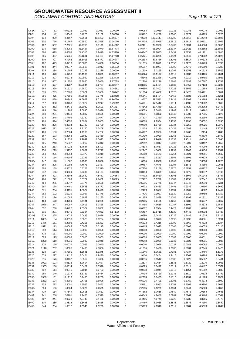
GROUNDWATER RESOURCE ASSESSMENT II DOCUMENT CONTROL AND HISTORY Page 109 of 129
Department: Water Affairs and Forestry
VERSION: 2.0
D82K 917 31 0.0222 0.0069 0.0063 0.00000 0 0.0063 0.0069 0.0222 0.0241 0.0075 0.0069D82L 754 42 1.0048 0.4220 0.3182 0.00000 0 0.3182 0.4220 1.0048 1.0179 0.4275 0.3223E10A 134 899 8.4167 75.6661 10.1393 17.86377 1 17.8638 133.3117 14.8289 14.6012 131.2648 17.5895E10B 202 736 8.1769 60.1820 12.1568 20.34076 1 20.3408 100.6968 13.6816 13.8617 102.0221 20.6085E10C 192 587 7.2021 42.2763 8.1171 14.24612 1 14.2461 74.1986 12.6403 12.6894 74.4868 14.3015E10D 235 518 6.4955 33.6467 7.9070 13.67474 1 13.6747 58.1904 11.2337 11.2425 58.2362 13.6855E10E 366 419 5.8309 24.4315 8.9419 14.63470 1 14.6347 39.9855 9.5431 9.5733 40.1121 14.6810E10F 386 407 5.6961 23.1831 8.9487 14.67708 1 14.6771 38.0235 9.3424 9.2949 37.8302 14.6025E10G 508 407 5.7252 23.3016 11.8372 19.26977 1 19.2698 37.9326 9.3201 9.3517 38.0614 19.3352E10H 162 495 6.8410 33.8630 5.4858 9.10554 1 9.1055 56.2071 11.3550 11.3226 56.0469 9.0796E10J 468 344 4.9017 16.8618 7.8913 8.65972 1 8.6597 18.5037 5.3790 5.4276 18.6709 8.7380E10K 235 284 3.1794 9.0295 2.1219 0.00000 0 2.1219 9.0295 3.1794 3.2258 9.1613 2.1529E21A 190 620 5.6758 35.1900 6.6861 10.66237 1 10.6624 56.1177 9.0512 9.0833 56.3165 10.7001E21B 223 497 4.6274 22.9982 5.1286 7.83478 1 7.8348 35.1336 7.0691 7.0319 34.9485 7.7935E21C 233 467 5.1152 23.8880 5.5659 7.27603 1 7.2760 31.2276 6.6868 6.5933 30.7907 7.1742E21D 242 627 6.3787 39.9944 9.6787 13.82847 1 13.8285 57.1424 9.1136 9.0452 56.7134 13.7246E21E 293 360 4.1611 14.9800 4.3891 6.08861 1 6.0886 20.7802 5.7723 5.8655 21.1158 6.1869E21F 379 289 2.7983 8.0871 3.0650 5.10142 1 5.1014 13.4602 4.6575 4.6426 13.4171 5.0851E21G 266 475 5.7599 27.3595 7.2776 9.53408 1 9.5341 35.8424 7.5458 7.6186 36.1884 9.6261E21H 404 429 5.0342 21.5967 8.7251 11.86070 1 11.8607 29.3582 6.8434 6.8367 29.3294 11.8491E21J 317 338 3.8468 13.0022 4.1217 5.49812 1 5.4981 17.3442 5.1314 5.1332 17.3502 5.5000E21K 330 352 4.3475 15.3032 5.0501 6.41417 1 6.4142 19.4369 5.5218 5.4620 19.2262 6.3447E21L 195 216 1.1963 2.5840 0.5039 0.00000 0 0.5039 2.5840 1.1963 1.2112 2.6162 0.5102E22A 750 251 1.9443 4.8802 3.6601 0.00000 0 3.6601 4.8802 1.9443 1.8739 4.7035 3.5276E22B 638 248 1.7492 4.3380 2.7677 0.00000 0 2.7677 4.3380 1.7492 1.7056 4.2299 2.6987E22C 490 324 2.4353 7.8904 3.8663 0.00000 0 3.8663 7.8904 2.4353 2.4090 7.8052 3.8245E22D 496 226 0.8734 1.9739 0.9790 0.00000 0 0.9790 1.9739 0.8734 0.9259 2.0925 1.0379E22E 1013 212 1.0434 2.2120 2.2408 0.00000 0 2.2408 2.2120 1.0434 1.0587 2.2444 2.2736E22F 400 163 0.7304 1.1906 0.4762 0.00000 0 0.4762 1.1906 0.7304 0.7432 1.2114 0.4846E22G 367 173 0.2266 0.3920 0.1439 0.00000 0 0.1439 0.3920 0.2266 0.2219 0.3839 0.1409E23A 762 254 3.1358 7.9649 6.0693 0.00000 0 6.0693 7.9649 3.1358 3.1514 8.0046 6.0995E23B 705 240 2.5007 6.0017 4.2312 0.00000 0 4.2312 6.0017 2.5007 2.5207 6.0497 4.2650E23C 318 213 2.7022 5.7557 1.8303 0.00000 0 1.8303 5.7557 2.7022 2.7233 5.8006 1.8446E23D 750 219 1.9937 4.3662 3.2747 0.00000 0 3.2747 4.3662 1.9937 1.9843 4.3456 3.2592E23E 564 265 3.0254 8.0173 4.5218 0.00000 0 4.5218 8.0173 3.0254 3.0521 8.0881 4.5617E23F 473 134 0.6905 0.9253 0.4377 0.00000 0 0.4377 0.9253 0.6905 0.6802 0.9115 0.4311E23G 747 190 1.1862 2.2538 1.6836 0.00000 0 1.6836 2.2538 1.1862 1.2136 2.3058 1.7225E23H 660 205 2.1794 4.4678 2.9487 0.00000 0 2.9487 4.4678 2.1794 2.1878 4.4850 2.9601E23J 895 139 0.5876 0.8168 0.7310 0.00000 0 0.7310 0.8168 0.5876 0.5951 0.8272 0.7403E23K 572 126 0.0269 0.0339 0.0194 0.00000 0 0.0194 0.0339 0.0269 0.0275 0.0347 0.0198E24A 255 393 4.8308 18.9850 4.8412 2.06663 0 4.8412 18.9850 4.8308 4.8662 19.1242 4.8767E24B 468 272 2.1589 5.8722 2.7482 0.98329 0 2.7482 5.8722 2.1589 2.1155 5.7542 2.6929E24C 784 235 1.3947 3.2775 2.5696 0.00000 0 2.5696 3.2775 1.3947 1.3749 3.2310 2.5331E24D 997 178 0.9451 1.6823 1.6772 0.00000 0 1.6772 1.6823 0.9451 0.9382 1.6700 1.6650E24E 671 204 0.9131 1.8627 1.2499 0.00000 0 1.2499 1.8627 0.9131 0.9109 1.8582 1.2469E24F 582 192 1.5639 3.0027 1.7476 0.00000 0 1.7476 3.0027 1.5639 1.5359 2.9489 1.7163E24G 633 174 0.1085 0.1888 0.1195 0.00000 0 0.1195 0.1888 0.1085 0.1098 0.1911 0.1209E24H 483 190 0.3253 0.6181 0.2985 0.00000 0 0.2985 0.6181 0.3253 0.3288 0.6247 0.3017E24J 1078 247 2.0087 4.9615 5.3485 0.00000 0 5.3485 4.9615 2.0087 2.1609 5.3374 5.7537E24K 652 238 0.4422 1.0524 0.6862 0.00000 0 0.6862 1.0524 0.4422 0.4289 1.0208 0.6655E24L 516 291 2.9345 8.5394 4.4063 6.64172 1 6.6417 12.8716 4.4232 4.4446 12.9338 6.6738E24M 529 265 1.9036 5.0445 2.6686 0.00000 0 2.6686 5.0445 1.9036 1.9485 5.1635 2.7315E31A 2865 84 0.0093 0.0078 0.0224 0.00000 0 0.0224 0.0078 0.0093 0.0096 0.0081 0.0231E31B 1476 151 0.2792 0.4216 0.6223 0.00000 0 0.6223 0.4216 0.2792 0.2869 0.4332 0.6394E31C 1572 113 0.0065 0.0073 0.0115 0.00000 0 0.0115 0.0073 0.0065 0.0065 0.0073 0.0115E31D 839 114 0.0000 0.0000 0.0000 0.00000 0 0.0000 0.0000 0.0000 0.0000 0.0000 0.0000E31E 478 157 0.0000 0.0000 0.0000 0.00000 0 0.0000 0.0000 0.0000 0.0000 0.0000 0.0000E31F 525 175 0.0003 0.0005 0.0003 0.00000 0 0.0003 0.0005 0.0003 0.0006 0.0011 0.0006E31G 1238 110 0.0035 0.0039 0.0048 0.00000 0 0.0048 0.0039 0.0035 0.0028 0.0031 0.0038E31H 726 150 0.0037 0.0056 0.0040 0.00000 0 0.0040 0.0056 0.0037 0.0041 0.0062 0.0045E32A 1118 207 1.8086 3.7438 4.1856 0.00000 0 4.1856 3.7438 1.8086 1.8331 3.7945 4.2423E32B 828 184 0.7381 1.3581 1.1245 0.00000 0 1.1245 1.3581 0.7381 0.7334 1.3495 1.1173E32C 638 227 1.3416 3.0454 1.9430 0.00000 0 1.9430 3.0454 1.3416 1.3563 3.0788 1.9643E32D 616 176 0.3132 0.5512 0.3396 0.00000 0 0.3396 0.5512 0.3132 0.3220 0.5667 0.3491E32E 1001 193 0.6536 1.2614 1.2627 0.00000 0 1.2627 1.2614 0.6536 0.6720 1.2970 1.2983E33A 1355 136 0.0314 0.0427 0.0579 0.00000 0 0.0579 0.0427 0.0314 0.0314 0.0427 0.0579E33B 702 114 0.0916 0.1044 0.0733 0.00000 0 0.0733 0.1044 0.0916 0.1054 0.1202 0.0843E33C 980 140 1.1235 1.5729 1.5414 0.00000 0 1.5414 1.5729 1.1235 1.1510 1.6114 1.5792E33D 1559 131 0.1118 0.1465 0.2283 0.00000 0 0.2283 0.1465 0.1118 0.1137 0.1489 0.2322E33E 1282 124 0.3791 0.4701 0.6026 0.00000 0 0.6026 0.4701 0.3791 0.3769 0.4674 0.5992E33F 725 212 2.3091 4.8953 3.5491 0.00000 0 3.5491 4.8953 2.3091 2.3203 4.9190 3.5663E33G 894 186 1.3564 2.5229 2.2555 0.00000 0 2.2555 2.5229 1.3564 1.3747 2.5569 2.2859E33H 719 134 0.7849 1.0518 0.7562 0.00000 0 0.7562 1.0518 0.7849 0.7876 1.0554 0.7588E40A 941 236 2.0961 4.9468 4.6549 0.00000 0 4.6549 4.9468 2.0961 2.0961 4.9468 4.6549E40B 707 241 2.0228 4.8749 3.4466 0.00000 0 3.4466 4.8749 2.0228 2.0235 4.8766 3.4478E40C 530 285 1.8838 5.3688 2.8455 0.00000 0 2.8455 5.3688 1.8838 1.8835 5.3680 2.8450E40D 544 284 1.6317 4.6340 2.5209 0.00000 0 2.5209 4.6340 1.6317 1.6084 4.5679 2.4849

GROUNDWATER RESOURCE ASSESSMENT II DOCUMENT CONTROL AND HISTORY Page 110 of 129
Department: Water Affairs and Forestry
VERSION: 2.0
F10A 460 64 0.0000 0.0000 0.0000 0.00000 0 0.0000 0.0000 0.0000 0.0000 0.0000 0.0000F10B 1089 62 0.5308 0.3291 0.3584 0.00000 0 0.3584 0.3291 0.5308 0.5190 0.3218 0.3504F10C 1176 53 1.3862 0.7347 0.8640 0.00000 0 0.8640 0.7347 1.3862 1.3863 0.7347 0.8641F20A 1120 99 0.0515 0.0510 0.0571 0.00000 0 0.0571 0.0510 0.0515 0.0518 0.0513 0.0574F20B 514 91 0.1241 0.1129 0.0580 0.00000 0 0.0580 0.1129 0.1241 0.1275 0.1160 0.0596F20C 613 80 0.0399 0.0319 0.0196 0.00000 0 0.0196 0.0319 0.0399 0.0479 0.0383 0.0235F20D 455 71 1.2687 0.9008 0.4099 0.00000 0 0.4099 0.9008 1.2687 1.2636 0.8972 0.4082F20E 435 92 0.9879 0.9089 0.3954 0.00000 0 0.3954 0.9089 0.9879 0.9856 0.9068 0.3944F30A 1954 162 0.0794 0.1286 0.2513 0.00000 0 0.2513 0.1286 0.0794 0.0721 0.1168 0.2282F30B 1462 107 0.0043 0.0046 0.0067 0.00000 0 0.0067 0.0046 0.0043 0.0044 0.0047 0.0069F30C 1655 184 0.6344 1.1673 1.9319 0.00000 0 1.9319 1.1673 0.6344 0.6400 1.1776 1.9489F30D 976 162 0.0777 0.1259 0.1229 0.00000 0 0.1229 0.1259 0.0777 0.0756 0.1225 0.1195F30E 1260 153 0.1660 0.2540 0.3200 0.00000 0 0.3200 0.2540 0.1660 0.1695 0.2593 0.3268F30F 1469 112 0.0193 0.0216 0.0318 0.00000 0 0.0318 0.0216 0.0193 0.0202 0.0226 0.0332F30G 980 102 0.5895 0.6013 0.5893 0.00000 0 0.5893 0.6013 0.5895 0.5888 0.6006 0.5886F40A 984 118 1.2433 1.4671 1.4436 0.00000 0 1.4436 1.4671 1.2433 1.2424 1.4660 1.4426F40B 404 130 0.1401 0.1821 0.0736 0.00000 0 0.0736 0.1821 0.1401 0.1483 0.1928 0.0779F40C 608 173 1.0597 1.8333 1.1146 0.00000 0 1.1146 1.8333 1.0597 1.0881 1.8824 1.1445F40D 741 123 1.0413 1.2808 0.9491 0.00000 0 0.9491 1.2808 1.0413 1.0408 1.2802 0.9486F40E 1065 186 1.0316 1.9188 2.0435 0.00000 0 2.0435 1.9188 1.0316 1.0162 1.8901 2.0130F40F 682 118 0.8738 1.0311 0.7032 0.00000 0 0.7032 1.0311 0.8738 0.8718 1.0287 0.7016F40G 348 168 1.1411 1.9170 0.6671 0.00000 0 0.6671 1.9170 1.1411 1.1684 1.9629 0.6831F40H 514 109 0.8382 0.9136 0.4696 0.00000 0 0.4696 0.9136 0.8382 0.8413 0.9170 0.4713F50A 1303 179 0.1291 0.2311 0.3011 0.00000 0 0.3011 0.2311 0.1291 0.1394 0.2495 0.3251F50B 603 208 0.4620 0.9610 0.5795 0.00000 0 0.5795 0.9610 0.4620 0.4444 0.9244 0.5574F50C 439 159 0.8819 1.4022 0.6156 0.00000 0 0.6156 1.4022 0.8819 0.8858 1.4084 0.6183F50D 687 112 1.8313 2.0511 1.4091 0.00000 0 1.4091 2.0511 1.8313 1.8202 2.0386 1.4005F50E 487 246 1.3406 3.2979 1.6061 0.00000 0 1.6061 3.2979 1.3406 1.3383 3.2922 1.6033F50F 575 133 1.7701 2.3542 1.3537 0.00000 0 1.3537 2.3542 1.7701 1.7822 2.3703 1.3629F50G 775 96 0.8935 0.8578 0.6648 0.00000 0 0.6648 0.8578 0.8935 0.8940 0.8582 0.6651F60A 572 103 0.7439 0.7662 0.4383 0.00000 0 0.4383 0.7662 0.7439 0.7466 0.7690 0.4399F60B 320 129 1.1672 1.5057 0.4818 0.00000 0 0.4818 1.5057 1.1672 1.1570 1.4925 0.4776F60C 622 114 1.3502 1.5392 0.9574 0.00000 0 0.9574 1.5392 1.3502 1.3244 1.5098 0.9391F60D 481 120 0.8595 1.0314 0.4961 0.00000 0 0.4961 1.0314 0.8595 0.8603 1.0324 0.4966F60E 795 116 0.7691 0.8922 0.7093 0.00000 0 0.7093 0.8922 0.7691 0.7699 0.8931 0.7100G10A 172 1580 9.9341 156.9588 26.9969 60.94227 1 60.9423 354.3155 22.4250 22.3636 353.3449 60.7753G10B 126 1245 10.0756 125.4412 15.8056 31.70651 1 31.7065 251.6390 20.2120 20.1702 251.1190 31.6410G10C 328 1009 9.8695 99.5833 32.6633 44.44725 1 44.4472 135.5099 13.4301 13.4856 136.0697 44.6309G10D 688 625 6.9590 43.4938 29.9237 36.59852 1 36.5985 53.1955 8.5113 8.5988 53.7425 36.9748G10E 394 640 6.2024 39.6954 15.6400 21.50044 1 21.5004 54.5697 8.5265 8.5105 54.4672 21.4601G10F 539 515 5.0094 25.7984 13.9053 19.30433 1 19.3043 35.8151 6.9544 6.9621 35.8548 19.3257G10G 186 1285 9.1795 117.9566 21.9399 35.35903 1 35.3590 190.1023 14.7940 14.8003 190.1839 35.3742G10H 675 411 3.1808 13.0731 8.8243 6.20517 0 8.8243 13.0731 3.1808 3.2060 13.1767 8.8942G10J 868 447 3.9598 17.7003 15.3639 9.99882 0 15.3639 17.7003 3.9598 4.0028 17.8925 15.5307G10K 1176 382 3.7889 14.4736 17.0210 0.00000 0 17.0210 14.4736 3.7889 3.7427 14.2971 16.8134G10L 1755 390 4.6225 18.0278 31.6387 0.00000 0 31.6387 18.0278 4.6225 4.6399 18.0956 31.7578G10M 2005 300 5.3938 16.1814 32.4437 0.00000 0 32.4437 16.1814 5.3938 5.3952 16.1856 32.4521G21A 523 408 7.6905 31.3772 16.4103 1.21572 0 16.4103 31.3772 7.6905 7.7316 31.5449 16.4980G21B 304 424 8.0652 34.1964 10.3957 0.00000 0 10.3957 34.1964 8.0652 8.0115 33.9688 10.3265G21C 244 523 5.1015 26.6808 6.5101 4.20815 0 6.5101 26.6808 5.1015 5.1185 26.7698 6.5318G21D 484 477 4.9397 23.5624 11.4042 6.85304 0 11.4042 23.5624 4.9397 4.9608 23.6630 11.4529G21E 531 531 6.1682 32.7531 17.3919 9.98658 0 17.3919 32.7531 6.1682 6.2218 33.0378 17.5430G21F 242 488 7.0605 34.4552 8.3382 3.79400 0 8.3382 34.4552 7.0605 7.1080 34.6870 8.3943G22A 238 684 16.3464 111.8094 26.6106 9.76843 0 26.6106 111.8094 16.3464 16.3356 111.7355 26.5930G22B 109 923 15.6377 144.3360 15.7326 9.61740 0 15.7326 144.3360 15.6377 15.7041 144.9488 15.7994G22C 254 605 9.9507 60.2017 15.2912 7.04647 0 15.2912 60.2017 9.9507 10.0026 60.5157 15.3710G22D 246 738 13.2405 97.7149 24.0379 11.39946 0 24.0379 97.7149 13.2405 13.2851 98.0440 24.1188G22E 271 572 8.6992 49.7594 13.4848 6.45785 0 13.4848 49.7594 8.6992 8.7197 49.8767 13.5166G22F 66 1465 11.2081 164.1987 10.8371 22.27966 1 22.2797 337.5705 23.0424 23.0400 337.5360 22.2774G22G 106 754 9.1147 68.7248 7.2848 4.70993 0 7.2848 68.7248 9.1147 9.2640 69.8506 7.4042G22H 227 669 9.6463 64.5337 14.6492 7.64052 0 14.6492 64.5337 9.6463 9.6849 64.7920 14.7078G22J 128 1002 10.2014 102.2180 13.0839 22.61650 1 22.6165 176.6914 17.6339 17.5563 175.9141 22.5170G22K 80 769 9.2041 70.7795 5.6624 9.21540 1 9.2154 115.1925 14.9795 14.8843 114.4603 9.1568G30A 761 260 5.4014 14.0436 10.6872 0.00000 0 10.6872 14.0436 5.4014 5.4237 14.1016 10.7313G30B 658 394 3.8433 15.1426 9.9638 5.63562 0 9.9638 15.1426 3.8433 3.7761 14.8778 9.7896G30C 351 410 5.6745 23.2655 8.1662 3.33177 0 8.1662 23.2655 5.6745 5.6554 23.1871 8.1387G30D 534 384 5.7214 21.9702 11.7321 0.00000 0 11.7321 21.9702 5.7214 5.7323 22.0120 11.7544G30E 352 249 4.9125 12.2321 4.3057 0.00000 0 4.3057 12.2321 4.9125 4.9314 12.2792 4.3223G30F 780 285 4.7033 13.4044 10.4554 0.00000 0 10.4554 13.4044 4.7033 4.7418 13.5141 10.5410G30G 647 253 3.3449 8.4626 5.4753 0.00000 0 5.4753 8.4626 3.3449 3.4457 8.7176 5.6403G30H 1077 214 1.9445 4.1612 4.4816 0.00000 0 4.4816 4.1612 1.9445 1.9622 4.1991 4.5224G40A 72 1121 8.8752 99.4910 7.1634 15.24784 1 15.2478 211.7756 18.8917 18.8091 210.8500 15.1812G40B 122 937 10.5788 99.1234 12.0930 18.94569 1 18.9457 155.2925 16.5734 16.7841 157.2670 19.1866G40C 145 1367 8.1807 111.8302 16.2154 41.38984 1 41.3898 285.4472 20.8813 20.6550 282.3539 40.9413G40D 327 984 8.3396 82.0617 26.8342 55.96141 1 55.9614 171.1358 17.3919 17.5842 173.0285 56.5803G40E 278 722 5.4907 39.6429 11.0207 10.16831 0 11.0207 39.6429 5.4907 5.4591 39.4147 10.9573G40F 422 515 5.0631 26.0750 11.0036 6.91382 0 11.0036 26.0750 5.0631 5.1120 26.3268 11.1099

GROUNDWATER RESOURCE ASSESSMENT II DOCUMENT CONTROL AND HISTORY Page 111 of 129
Department: Water Affairs and Forestry
VERSION: 2.0
G40G 220 724 8.9056 64.4765 14.1848 8.11041 0 14.1848 64.4765 8.9056 8.9961 65.1318 14.3290G40H 96 698 9.6117 67.0897 6.4406 3.20507 0 6.4406 67.0897 9.6117 9.7438 68.0117 6.5291G40J 169 613 6.6113 40.5273 6.8491 4.21592 0 6.8491 40.5273 6.6113 6.6754 40.9202 6.9155G40K 429 496 4.0150 19.9144 8.5433 5.90579 0 8.5433 19.9144 4.0150 3.9781 19.7314 8.4648G40L 385 569 5.8759 33.4339 12.8720 6.75533 0 12.8720 33.4339 5.8759 5.8617 33.3531 12.8409G40M 393 574 4.7256 27.1249 10.6601 7.06931 0 10.6601 27.1249 4.7256 4.7630 27.3396 10.7445G50A 243 545 5.4495 29.6998 7.2170 3.44569 0 7.2170 29.6998 5.4495 5.4589 29.7510 7.2295G50B 339 531 3.5265 18.7257 6.3480 4.46033 0 6.3480 18.7257 3.5265 3.5476 18.8378 6.3860G50C 421 489 4.1213 20.1532 8.4845 4.78493 0 8.4845 20.1532 4.1213 4.1737 20.4094 8.5924G50D 572 431 2.1942 9.4570 5.4094 4.89293 0 5.4094 9.4570 2.1942 2.2472 9.6854 5.5401G50E 313 448 3.5772 16.0259 5.0161 2.98399 0 5.0161 16.0259 3.5772 3.5848 16.0599 5.0267G50F 290 453 5.0695 22.9648 6.6598 2.63802 0 6.6598 22.9648 5.0695 5.1164 23.1773 6.7214G50G 380 371 1.5248 5.6570 2.1497 2.17081 1 2.1708 5.7127 1.5398 1.5326 5.6859 2.1607G50H 890 371 1.7346 6.4354 5.7275 4.97571 0 5.7275 6.4354 1.7346 1.7537 6.5062 5.7905G50J 517 365 3.1806 11.6092 6.0020 2.82014 0 6.0020 11.6092 3.1806 3.2175 11.7439 6.0716G50K 163 441 3.7885 16.7073 2.7233 1.33439 0 2.7233 16.7073 3.7885 3.8050 16.7801 2.7351H10A 234 512 5.1155 26.1914 6.1288 11.69396 1 11.6940 49.9742 9.7606 9.7513 49.9267 11.6828H10B 162 708 8.2853 58.6599 9.5029 13.98270 1 13.9827 86.3130 12.1911 12.3980 87.7778 14.2200H10C 260 674 6.3475 42.7822 11.1234 20.74476 1 20.7448 79.7875 11.8379 11.9344 80.4379 20.9138H10D 97 1019 10.1509 103.4377 10.0335 15.18005 1 15.1800 156.4953 15.3577 15.4996 157.9409 15.3203H10E 85 1850 9.7387 180.1660 15.3141 30.64888 1 30.6489 360.5751 19.4905 19.6535 363.5898 30.9051H10F 248 784 7.8788 61.7698 15.3189 26.13076 1 26.1308 105.3660 13.4395 13.5123 105.9364 26.2722H10G 270 788 8.4241 66.3819 17.9231 28.83387 1 28.8339 106.7921 13.5523 13.5424 106.7141 28.8128H10H 187 886 7.2572 64.2988 12.0239 23.84147 1 23.8415 127.4945 14.3899 13.9762 123.8291 23.1560H10J 214 1595 10.3641 165.3074 35.3758 63.38965 1 63.3897 296.2133 18.5714 18.6170 296.9412 63.5454H10K 194 1225 9.3665 114.7396 22.2595 39.49134 1 39.4913 203.5636 16.6174 16.5414 202.6322 39.3106H10L 96 476 4.9242 23.4392 2.2502 0.00000 0 2.2502 23.4392 4.9242 4.9952 23.7772 2.2826H20A 140 357 4.2327 15.1107 2.1155 0.00000 0 2.1155 15.1107 4.2327 4.2201 15.0658 2.1092H20B 124 590 8.2162 48.4756 6.0110 1.09936 0 6.0110 48.4756 8.2162 8.1969 48.3617 5.9969H20C 81 643 5.6009 36.0138 2.9171 0.92110 0 2.9171 36.0138 5.6009 5.7471 36.9539 2.9933H20D 101 696 8.7082 60.6091 6.1215 8.67695 1 8.6770 85.9104 12.3435 12.5468 87.3257 8.8199H20E 95 906 9.3680 84.8741 8.0630 12.48752 1 12.4875 131.4475 14.5086 14.4666 131.0674 12.4514H20F 117 797 9.6169 76.6467 8.9677 2.80869 0 8.9677 76.6467 9.6169 9.6477 76.8922 8.9964H20G 85 680 7.3954 50.2887 4.2745 1.28727 0 4.2745 50.2887 7.3954 7.1468 48.5982 4.1309H20H 89 300 3.8625 11.5875 1.0313 0.20910 0 1.0313 11.5875 3.8625 3.5835 10.7505 0.9568H30A 284 443 4.4217 19.5881 5.5630 0.00000 0 5.5630 19.5881 4.4217 4.4511 19.7184 5.6000H30B 315 374 4.7233 17.6651 5.5645 0.00000 0 5.5645 17.6651 4.7233 4.6945 17.5574 5.5306H30C 327 480 6.5880 31.6224 10.3405 0.00000 0 10.3405 31.6224 6.5880 6.6421 31.8821 10.4254H30D 127 385 7.0725 27.2291 3.4581 0.00000 0 3.4581 27.2291 7.0725 7.0096 26.9870 3.4273H30E 154 441 4.0994 18.0784 2.7841 0.00000 0 2.7841 18.0784 4.0994 3.9573 17.4517 2.6876H40A 184 426 4.2547 18.1250 3.3350 0.43231 0 3.3350 18.1250 4.2547 4.3517 18.5382 3.4110H40B 241 578 7.2049 41.6443 10.0363 1.47234 0 10.0363 41.6443 7.2049 7.1494 41.3235 9.9590H40C 272 375 3.2894 12.3353 3.3552 1.24274 0 3.3552 12.3353 3.2894 3.1673 11.8774 3.2306H40D 182 557 3.5823 19.9534 3.6315 3.23202 0 3.6315 19.9534 3.5823 3.6695 20.4391 3.7199H40E 285 539 4.2921 23.1344 6.5933 4.83016 0 6.5933 23.1344 4.2921 4.2403 22.8552 6.5137H40F 340 293 1.0974 3.2154 1.0932 0.52835 0 1.0932 3.2154 1.0974 1.1127 3.2602 1.1085H40G 263 464 2.4862 11.5360 3.0340 3.34033 1 3.3403 12.7009 2.7373 2.5871 12.0041 3.1571H40H 208 461 4.5647 21.0433 4.3770 2.19945 0 4.3770 21.0433 4.5647 4.4814 20.6593 4.2971H40J 204 424 3.8044 16.1307 3.2907 1.86710 0 3.2907 16.1307 3.8044 3.6261 15.3747 3.1364H40K 271 406 2.2267 9.0404 2.4499 2.17513 0 2.4499 9.0404 2.2267 2.2665 9.2020 2.4937H40L 159 381 2.9207 11.1279 1.7693 0.84815 0 1.7693 11.1279 2.9207 2.7739 10.5686 1.6804H50A 265 335 1.4697 4.9235 1.3047 0.93637 0 1.3047 4.9235 1.4697 1.5509 5.1955 1.3768H50B 431 389 2.7669 10.7632 4.6390 2.80561 0 4.6390 10.7632 2.7669 2.7578 10.7278 4.6237H60A 73 1895 9.1501 173.3944 12.6578 30.00324 1 30.0032 411.0033 21.6888 21.4613 406.6916 29.6885H60B 210 1127 8.2219 92.6608 19.4588 38.99625 1 38.9963 185.6964 16.4771 16.2438 183.0676 38.4442H60C 217 891 6.8844 61.3400 13.3108 28.03883 1 28.0388 129.2112 14.5018 14.4311 128.5811 27.9021H60D 227 652 5.7397 37.4228 8.4950 13.27834 1 13.2783 58.4949 8.9716 8.9064 58.0697 13.1818H60E 170 640 5.3719 34.3802 5.8446 9.25907 1 9.2591 54.4651 8.5102 8.4800 54.2720 9.2262H60F 165 582 4.8105 27.9971 4.6195 7.21997 1 7.2200 43.7574 7.5185 7.4123 43.1396 7.1180H60G 141 475 4.3653 20.7352 2.9237 3.80241 1 3.8024 26.9675 5.6774 5.7154 27.1482 3.8279H60H 253 464 3.5588 16.5128 4.1777 6.43114 1 6.4311 25.4195 5.4783 5.4156 25.1284 6.3575H60J 293 457 2.7002 12.3399 3.6156 7.18068 1 7.1807 24.5074 5.3627 5.2689 24.0789 7.0551H60K 262 371 2.1589 8.0095 2.0985 3.57441 1 3.5744 13.6428 3.6773 3.6114 13.3983 3.5104H60L 230 361 1.4797 5.3417 1.2286 2.92250 1 2.9225 12.7065 3.5198 3.4512 12.4588 2.8655H70A 224 414 1.8483 7.6520 1.7140 4.18864 1 4.1886 18.6993 4.5167 4.1538 17.1967 3.8521H70B 153 694 3.1607 21.9353 3.3561 22.31097 1 22.3110 145.8234 21.0120 20.1760 140.0214 21.4233H70C 287 373 3.8650 14.4165 4.1375 0.78012 0 4.1375 14.4165 3.8650 3.9488 14.7290 4.2272H70D 170 635 4.1049 26.0661 4.4312 20.69822 1 20.6982 121.7542 19.1739 18.4672 117.2667 19.9353H70E 157 741 3.1495 23.3378 3.6640 25.84923 1 25.8492 164.6448 22.2193 21.9284 162.4894 25.5108H70F 121 573 2.9877 17.1195 2.0715 12.14945 1 12.1494 100.4087 17.5233 16.6108 95.1799 11.5168H70G 652 366 0.4396 1.6089 1.0490 3.53560 1 3.5356 5.4227 1.4816 1.3562 4.9637 3.2363H70H 400 395 1.7000 6.7150 2.6860 2.64133 0 2.6860 6.7150 1.7000 1.8142 7.1661 2.8664H70J 551 383 1.2162 4.6580 2.5666 3.42572 1 3.4257 6.2173 1.6233 1.6303 6.2440 3.4405H70K 207 458 3.1321 14.3450 2.9694 2.09622 0 2.9694 14.3450 3.1321 3.2097 14.7004 3.0430H80A 149 597 5.2074 31.0882 4.6321 16.04364 1 16.0436 107.6754 18.0361 18.1408 108.3006 16.1368H80B 123 792 5.1158 40.5171 4.9836 22.64007 1 22.6401 184.0656 23.2406 22.9349 181.6444 22.3423H80C 285 479 3.0453 14.5870 4.1573 3.24503 0 4.1573 14.5870 3.0453 2.9511 14.1358 4.0287

GROUNDWATER RESOURCE ASSESSMENT II DOCUMENT CONTROL AND HISTORY Page 112 of 129
Department: Water Affairs and Forestry
VERSION: 2.0
H80D 231 412 2.7772 11.4421 2.6431 1.86228 0 2.6431 11.4421 2.7772 2.8079 11.5685 2.6723H80E 373 431 4.9586 21.3716 7.9716 3.39245 0 7.9716 21.3716 4.9586 5.0538 21.7819 8.1246H80F 204 533 5.5127 29.3827 5.9941 3.39669 0 5.9941 29.3827 5.5127 5.4654 29.1306 5.9426H90A 179 645 5.3059 34.2231 6.1259 20.92466 1 20.9247 116.8975 18.1236 18.0475 116.4064 20.8367H90B 118 664 4.8007 31.8766 3.7614 14.56958 1 14.5696 123.4710 18.5950 18.9055 125.5325 14.8128H90C 218 467 3.5199 16.4379 3.5835 2.13729 0 3.5835 16.4379 3.5199 3.4500 16.1115 3.5123H90D 602 425 4.0142 17.0604 10.2703 4.94271 0 10.2703 17.0604 4.0142 4.0388 17.1649 10.3333H90E 496 490 3.9326 19.2697 9.5578 6.24465 0 9.5578 19.2697 3.9326 3.9368 19.2903 9.5680J11A 438 295 2.1719 6.4071 2.8063 0.00000 0 2.8063 6.4071 2.1719 2.1314 6.2876 2.7540J11B 738 252 1.4524 3.6600 2.7011 0.00000 0 2.7011 3.6600 1.4524 1.4128 3.5603 2.6275J11C 292 204 0.2741 0.5592 0.1633 0.00000 0 0.1633 0.5592 0.2741 0.2508 0.5116 0.1494J11D 801 240 1.7289 4.1494 3.3236 0.00000 0 3.3236 4.1494 1.7289 1.6696 4.0070 3.2096J11E 812 188 0.8294 1.5593 1.2661 0.00000 0 1.2661 1.5593 0.8294 0.8260 1.5529 1.2609J11F 344 209 0.5486 1.1466 0.3944 0.00000 0 0.3944 1.1466 0.5486 0.5500 1.1495 0.3954J11G 604 167 0.1266 0.2114 0.1277 0.00000 0 0.1277 0.2114 0.1266 0.1798 0.3003 0.1814J11H 651 240 2.8054 6.7330 4.3832 0.00000 0 4.3832 6.7330 2.8054 2.9088 6.9811 4.5447J11J 450 304 4.0369 12.2722 5.5225 0.00000 0 5.5225 12.2722 4.0369 3.9334 11.9575 5.3809J11K 516 221 2.1262 4.6989 2.4246 0.00000 0 2.4246 4.6989 2.1262 2.1505 4.7526 2.4523J12A 181 437 3.4964 15.2793 2.7655 0.00000 0 2.7655 15.2793 3.4964 3.5436 15.4855 2.8029J12B 251 268 2.2488 6.0268 1.5127 0.00000 0 1.5127 6.0268 2.2488 2.2576 6.0504 1.5186J12C 366 287 1.3443 3.8581 1.4121 0.00000 0 1.4121 3.8581 1.3443 1.3090 3.7568 1.3750J12D 831 290 2.9276 8.4900 7.0552 0.00000 0 7.0552 8.4900 2.9276 2.9439 8.5373 7.0945J12E 356 307 1.8295 5.6166 1.9995 0.00000 0 1.9995 5.6166 1.8295 1.8965 5.8223 2.0727J12F 710 243 3.2364 7.8645 5.5838 0.00000 0 5.5838 7.8645 3.2364 3.2468 7.8897 5.6017J12G 761 277 2.6281 7.2798 5.5400 0.00000 0 5.5400 7.2798 2.6281 2.6990 7.4762 5.6894J12H 549 260 2.7483 7.1456 3.9229 0.00000 0 3.9229 7.1456 2.7483 2.7066 7.0372 3.8634J12J 549 250 3.3188 8.2970 4.5551 0.00000 0 4.5551 8.2970 3.3188 3.3487 8.3718 4.5961J12K 517 193 2.3604 4.5556 2.3552 0.00000 0 2.3552 4.5556 2.3604 2.4087 4.6488 2.4034J12L 758 314 2.3555 7.3963 5.6064 0.00000 0 5.6064 7.3963 2.3555 2.8284 8.8812 6.7319J12M 483 290 1.8503 5.3659 2.5917 0.00000 0 2.5917 5.3659 1.8503 1.7044 4.9428 2.3874J13A 518 295 2.3446 6.9166 3.5828 0.00000 0 3.5828 6.9166 2.3446 2.6063 7.6886 3.9827J13B 402 306 2.1204 6.4884 2.6083 0.00000 0 2.6083 6.4884 2.1204 2.1985 6.7274 2.7044J13C 435 351 1.6034 5.6279 2.4482 0.00000 0 2.4482 5.6279 1.6034 1.6477 5.7834 2.5158J21A 854 230 1.8054 4.1524 3.5462 0.00000 0 3.5462 4.1524 1.8054 1.7598 4.0475 3.4566J21B 530 188 0.4633 0.8710 0.4616 0.00000 0 0.4616 0.8710 0.4633 0.4336 0.8152 0.4320J21C 526 166 0.1388 0.2304 0.1212 0.00000 0 0.1212 0.2304 0.1388 0.1375 0.2283 0.1201J21D 650 155 0.2544 0.3943 0.2563 0.00000 0 0.2563 0.3943 0.2544 0.2493 0.3864 0.2512J21E 504 154 0.3348 0.5156 0.2599 0.00000 0 0.2599 0.5156 0.3348 0.3429 0.5281 0.2661J22A 436 233 3.0844 7.1867 3.1334 0.00000 0 3.1334 7.1867 3.0844 3.0818 7.1806 3.1307J22B 322 205 1.7539 3.5955 1.1577 0.00000 0 1.1577 3.5955 1.7539 1.7523 3.5922 1.1567J22C 364 197 1.5146 2.9838 1.0861 0.00000 0 1.0861 2.9838 1.5146 1.4758 2.9073 1.0583J22D 680 162 1.0278 1.6650 1.1322 0.00000 0 1.1322 1.6650 1.0278 1.0092 1.6349 1.1117J22E 834 159 0.8025 1.2760 1.0642 0.00000 0 1.0642 1.2760 0.8025 0.7919 1.2591 1.0501J22F 296 288 0.3244 0.9343 0.2765 0.00000 0 0.2765 0.9343 0.3244 0.3156 0.9089 0.2690J22G 567 221 2.3720 5.2421 2.9723 0.00000 0 2.9723 5.2421 2.3720 2.3776 5.2545 2.9793J22H 807 230 1.9660 4.5218 3.6491 0.00000 0 3.6491 4.5218 1.9660 1.9513 4.4880 3.6218J22J 378 187 1.0676 1.9964 0.7546 0.00000 0 0.7546 1.9964 1.0676 1.0424 1.9493 0.7368J22K 479 151 0.4504 0.6801 0.3258 0.00000 0 0.3258 0.6801 0.4504 0.4328 0.6535 0.3130J23A 762 127 0.2829 0.3593 0.2738 0.00000 0 0.2738 0.3593 0.2829 0.2775 0.3524 0.2685J23B 782 147 0.4202 0.6177 0.4830 0.00000 0 0.4830 0.6177 0.4202 0.4137 0.6081 0.4756J23C 514 124 0.3622 0.4491 0.2309 0.00000 0 0.2309 0.4491 0.3622 0.3612 0.4479 0.2302J23D 708 178 0.5836 1.0388 0.7355 0.00000 0 0.7355 1.0388 0.5836 0.6124 1.0901 0.7718J23E 225 329 3.1297 10.2967 2.3168 2.06103 0 2.3168 10.2967 3.1297 3.2995 10.8554 2.4425J23F 478 194 0.9861 1.9130 0.9144 0.28097 0 0.9144 1.9130 0.9861 1.0440 2.0254 0.9681J23G 241 98 0.0000 0.0000 0.0000 0.00000 0 0.0000 0.0000 0.0000 0.0000 0.0000 0.0000J23H 264 199 1.2780 2.5432 0.6714 0.10136 0 0.6714 2.5432 1.2780 1.3604 2.7072 0.7147J23J 229 308 2.5060 7.7185 1.7675 1.82816 1 1.8282 7.9832 2.5920 2.6969 8.3065 1.9022J24A 926 203 1.1942 2.4242 2.2448 0.00000 0 2.2448 2.4242 1.1942 1.1672 2.3694 2.1941J24B 768 160 0.3750 0.6000 0.4608 0.00000 0 0.4608 0.6000 0.3750 0.3673 0.5877 0.4513J24C 861 146 0.1022 0.1492 0.1285 0.00000 0 0.1285 0.1492 0.1022 0.0978 0.1428 0.1229J24D 926 128 0.0286 0.0366 0.0339 0.00000 0 0.0339 0.0366 0.0286 0.0273 0.0349 0.0324J24E 862 134 0.3670 0.4918 0.4239 0.00000 0 0.4239 0.4918 0.3670 0.3617 0.4847 0.4178J24F 282 222 2.1151 4.6955 1.3241 0.00000 0 1.3241 4.6955 2.1151 2.2372 4.9666 1.4006J25A 354 289 2.2627 6.5392 2.3149 2.43966 1 2.4397 6.8917 2.3847 2.3615 6.8247 2.4160J25B 397 326 2.9134 9.4977 3.7706 3.98088 1 3.9809 10.0274 3.0759 3.0148 9.8282 3.9018J25C 181 288 2.1350 6.1488 1.1129 0.05344 0 1.1129 6.1488 2.1350 2.1586 6.2168 1.1252J25D 210 365 1.8699 6.8251 1.4333 2.71475 1 2.7148 12.9274 3.5418 3.4303 12.5206 2.6293J25E 287 245 1.3628 3.3389 0.9583 0.04042 0 0.9583 3.3389 1.3628 1.3683 3.3523 0.9621J31A 447 441 4.1438 18.2742 8.1685 3.08493 0 8.1685 18.2742 4.1438 4.1378 18.2477 8.1567J31B 200 359 2.3124 8.3015 1.6603 0.78864 0 1.6603 8.3015 2.3124 2.3052 8.2757 1.6551J31C 168 369 3.3982 12.5394 2.1066 0.59833 0 2.1066 12.5394 3.3982 3.5565 13.1235 2.2047J31D 304 300 2.3829 7.1487 2.1732 0.62267 0 2.1732 7.1487 2.3829 2.3521 7.0563 2.1451J32A 415 154 0.1110 0.1709 0.0709 0.00000 0 0.0709 0.1709 0.1110 0.1084 0.1669 0.0693J32B 643 160 0.0461 0.0738 0.0474 0.00000 0 0.0474 0.0738 0.0461 0.0385 0.0616 0.0396J32C 734 136 0.0157 0.0214 0.0157 0.00000 0 0.0157 0.0214 0.0157 0.0160 0.0218 0.0160J32D 302 160 0.0058 0.0093 0.0028 0.00000 0 0.0028 0.0093 0.0058 0.0052 0.0083 0.0025J32E 971 234 0.8888 2.0798 2.0195 0.00000 0 2.0195 2.0798 0.8888 0.8956 2.0957 2.0349

GROUNDWATER RESOURCE ASSESSMENT II DOCUMENT CONTROL AND HISTORY Page 113 of 129
Department: Water Affairs and Forestry
VERSION: 2.0
J33A 449 393 2.7961 10.9887 4.9339 1.75154 0 4.9339 10.9887 2.7961 2.7969 10.9918 4.9353J33B 591 437 3.3058 14.4463 8.5378 3.05212 0 8.5378 14.4463 3.3058 3.3111 14.4695 8.5515J33C 428 293 2.0432 5.9866 2.5623 0.17542 0 2.5623 5.9866 2.0432 2.1290 6.2380 2.6699J33D 259 379 3.6447 13.8134 3.5777 3.52259 0 3.5777 13.8134 3.6447 3.7220 14.1064 3.6536J33E 329 446 2.7276 12.1651 4.0023 7.45691 1 7.4569 22.6654 5.0819 4.9920 22.2643 7.3250J33F 366 343 1.6155 5.5412 2.0281 3.92087 1 3.9209 10.7128 3.1233 3.0273 10.3836 3.8004J34A 252 477 2.7051 12.9033 3.2516 1.79476 0 3.2516 12.9033 2.7051 2.7536 13.1347 3.3099J34B 342 569 3.1690 18.0316 6.1668 4.10361 0 6.1668 18.0316 3.1690 3.2143 18.2894 6.2550J34C 319 674 4.6133 31.0936 9.9189 6.69543 0 9.9189 31.0936 4.6133 4.6744 31.5055 10.0502J34D 354 471 2.4417 11.5004 4.0711 2.73479 0 4.0711 11.5004 2.4417 2.4749 11.6568 4.1265J34E 258 427 2.1057 8.9913 2.3198 1.54233 0 2.3198 8.9913 2.1057 2.1982 9.3863 2.4217J34F 320 415 1.8350 7.6153 2.4369 1.66666 0 2.4369 7.6153 1.8350 1.8472 7.6659 2.4531J35A 428 418 3.2597 13.6255 5.8317 7.54542 1 7.5454 17.6295 4.2176 4.1649 17.4093 7.4512J35B 651 411 2.7531 11.3152 7.3662 3.49686 0 7.3662 11.3152 2.7531 2.6337 10.8245 7.0468J35C 265 373 1.6142 6.0210 1.5956 1.08017 0 1.5956 6.0210 1.6142 1.7075 6.3690 1.6878J35D 507 407 3.0338 12.3476 6.2602 8.69029 1 8.6903 17.1406 4.2115 4.1407 16.8526 8.5443J35E 215 270 1.5640 4.2228 0.9079 1.22921 1 1.2292 5.7172 2.1175 2.0745 5.6012 1.2042J35F 500 341 1.5812 5.3919 2.6959 5.81475 1 5.8148 11.6295 3.4104 3.3799 11.5255 5.7627J40A 454 418 1.2666 5.2944 2.4037 10.01366 1 10.0137 22.0565 5.2767 5.3239 22.2539 10.1033J40B 222 431 2.1096 9.0924 2.0185 5.61739 1 5.6174 25.3035 5.8709 6.0404 26.0341 5.7796J40C 436 521 2.4529 12.7796 5.5719 14.52124 1 14.5212 33.3056 6.3926 6.1923 32.2619 14.0662J40D 655 446 2.0412 9.1038 5.9630 8.94874 1 8.9487 13.6622 3.0633 3.0065 13.4090 8.7829J40E 554 440 2.6936 11.8518 6.5659 7.30694 1 7.3069 13.1894 2.9976 3.0247 13.3087 7.3730K10A 178 450 2.6903 12.1064 2.1549 2.25035 1 2.2503 12.6424 2.8094 2.8139 12.6626 2.2539K10B 171 446 2.0967 9.3513 1.5991 2.12003 1 2.1200 12.3979 2.7798 2.7966 12.4728 2.1329K10C 159 493 2.6454 13.0418 2.0736 4.25808 1 4.2581 26.7804 5.4321 5.4218 26.7295 4.2500K10D 164 454 2.6214 11.9012 1.9518 2.13059 1 2.1306 12.9914 2.8615 2.8454 12.9181 2.1186K10E 133 679 4.3846 29.7714 3.9596 15.01772 1 15.0177 112.9152 16.6296 16.6436 113.0100 15.0303K10F 106 502 3.8086 19.1192 2.0266 1.79331 0 2.0266 19.1192 3.8086 3.7973 19.0624 2.0206K20A 168 722 5.1902 37.4732 6.2955 21.13023 1 21.1302 125.7752 17.4204 17.3784 125.4720 21.0793K30A 196 753 5.7114 43.0068 8.4293 27.73196 1 27.7320 141.4896 18.7901 18.7240 140.9917 27.6344K30B 139 787 5.7840 45.5201 6.3273 22.14298 1 22.1430 159.3020 20.2417 20.1889 158.8866 22.0852K30C 190 805 6.2033 49.9366 9.4879 28.47165 1 28.4717 149.8508 18.6150 18.7364 150.8280 28.6573K30D 178 724 6.3844 46.2231 8.2277 19.32858 1 19.3286 108.5875 14.9983 15.0987 109.3146 19.4580K40A 87 706 5.9801 42.2195 3.6731 10.18350 1 10.1835 117.0518 16.5796 16.7892 118.5318 10.3123K40B 112 846 7.0600 59.7276 6.6895 14.21893 1 14.2189 126.9547 15.0065 15.0940 127.6952 14.3019K40C 100 930 7.4865 69.6245 6.9624 18.79657 1 18.7966 187.9657 20.2114 20.2187 188.0339 18.8034K40D 130 757 7.5073 56.8303 7.3879 18.16251 1 18.1625 139.7116 18.4560 18.5566 140.4735 18.2616K40E 268 864 7.3335 63.3614 16.9809 25.49444 1 25.4944 95.1285 11.0102 11.0222 95.2318 25.5221K50A 235 850 6.7084 57.0214 13.4000 28.02341 1 28.0234 119.2485 14.0292 14.0557 119.4735 28.0763K50B 203 882 6.9234 61.0644 12.3961 25.23898 1 25.2390 124.3299 14.0964 14.1401 124.7157 25.3173K60A 161 664 5.2221 34.6747 5.5826 6.66016 1 6.6602 41.3675 6.2300 6.3720 42.3101 6.8119K60B 143 754 4.2725 32.2147 4.6067 9.41547 1 9.4155 65.8425 8.7324 8.7685 66.1145 9.4544K60C 161 744 5.3005 39.4357 6.3492 11.26467 1 11.2647 69.9669 9.4042 9.4752 70.4955 11.3498K60D 292 815 6.2719 51.1160 14.9259 24.53023 1 24.5302 84.0076 10.3077 10.4948 85.5326 24.9755K60E 100 775 6.8674 53.2224 5.3222 5.96405 1 5.9640 59.6405 7.6955 7.6962 59.6456 5.9646K60F 242 807 6.1656 49.7564 12.0410 13.39924 1 13.3992 55.3687 6.8611 6.8896 55.5991 13.4550K60G 167 860 6.9110 59.4346 9.9256 10.73705 1 10.7370 64.2937 7.4760 7.5008 64.5069 10.7726K70A 170 920 8.2624 76.0141 12.9224 13.88522 1 13.8852 81.6778 8.8780 8.8861 81.7521 13.8979K70B 106 997 9.6018 95.7299 10.1474 22.14259 1 22.1426 208.8923 20.9521 21.0474 209.8426 22.2433K80A 146 1030 9.6247 99.1344 14.4736 41.32004 1 41.3200 283.0140 27.4771 27.6603 284.9011 41.5956K80B 208 1031 9.3043 95.9273 19.9529 55.09731 1 55.0973 264.8909 25.6926 26.0210 268.2765 55.8015K80C 189 1017 8.7358 88.8431 16.7913 44.77838 1 44.7784 236.9227 23.2962 23.2784 236.7413 44.7441K80D 176 936 7.5598 70.7597 12.4537 36.84108 1 36.8411 209.3243 22.3637 22.4322 209.9654 36.9539K80E 266 895 7.9556 71.2026 18.9399 22.86109 1 22.8611 85.9440 9.6027 9.6468 86.3389 22.9661K80F 221 769 7.1391 54.8997 12.1328 14.64525 1 14.6452 66.2681 8.6174 8.6731 66.6961 14.7398K90A 214 716 5.7962 41.5008 8.8812 12.16147 1 12.1615 56.8293 7.9371 8.1916 58.6519 12.5515K90B 150 774 6.2739 48.5600 7.2840 10.25543 1 10.2554 68.3696 8.8333 9.0149 69.7753 10.4663K90C 267 596 3.8948 23.2130 6.1979 5.59837 0 6.1979 23.2130 3.8948 3.9812 23.7280 6.3354K90D 215 693 5.5231 38.2751 8.2291 6.98313 0 8.2291 38.2751 5.5231 5.5823 38.6853 8.3173K90E 176 676 6.3421 42.8726 7.5456 5.14697 0 7.5456 42.8726 6.3421 6.3543 42.9551 7.5601K90F 250 699 5.7822 40.4176 10.1044 7.91161 0 10.1044 40.4176 5.7822 5.8274 40.7335 10.1834K90G 286 654 5.0562 33.0675 9.4573 7.29797 0 9.4573 33.0675 5.0562 5.1159 33.4580 9.5690L11A 930 218 2.3381 5.0971 4.7403 0.00000 0 4.7403 5.0971 2.3381 2.3556 5.1352 4.7757L11B 875 235 3.1885 7.4930 6.5564 0.00000 0 6.5564 7.4930 3.1885 3.1964 7.5115 6.5726L11C 568 241 3.0446 7.3375 4.1677 0.00000 0 4.1677 7.3375 3.0446 3.0326 7.3086 4.1513L11D 1286 224 2.8155 6.3067 8.1104 0.00000 0 8.1104 6.3067 2.8155 2.8211 6.3193 8.1266L11E 456 227 2.9533 6.7040 3.0570 0.00000 0 3.0570 6.7040 2.9533 2.9471 6.6899 3.0506L11F 745 220 2.3348 5.1366 3.8267 0.00000 0 3.8267 5.1366 2.3348 2.3150 5.0930 3.7943L11G 2024 195 0.9802 1.9114 3.8687 0.00000 0 3.8687 1.9114 0.9802 0.9579 1.8679 3.7806L12A 906 159 0.0263 0.0418 0.0379 0.00000 0 0.0379 0.0418 0.0263 0.0247 0.0393 0.0356L12B 519 192 0.1511 0.2901 0.1506 0.00000 0 0.1506 0.2901 0.1511 0.1443 0.2771 0.1438L12C 1068 152 0.0055 0.0084 0.0089 0.00000 0 0.0089 0.0084 0.0055 0.0046 0.0070 0.0075L12D 870 170 0.0008 0.0014 0.0012 0.00000 0 0.0012 0.0014 0.0008 0.0008 0.0014 0.0012L21A 609 244 2.2268 5.4334 3.3089 0.00000 0 3.3089 5.4334 2.2268 2.2180 5.4119 3.2959L21B 756 250 1.8674 4.6685 3.5294 0.00000 0 3.5294 4.6685 1.8674 1.8697 4.6743 3.5337L21C 1033 300 2.8194 8.4582 8.7373 0.00000 0 8.7373 8.4582 2.8194 2.8272 8.4816 8.7615

GROUNDWATER RESOURCE ASSESSMENT II DOCUMENT CONTROL AND HISTORY Page 114 of 129
Department: Water Affairs and Forestry
VERSION: 2.0
L21D 865 367 3.0635 11.2430 9.7252 0.00000 0 9.7252 11.2430 3.0635 3.0766 11.2911 9.7668L21E 712 289 2.4891 7.1935 5.1218 0.00000 0 5.1218 7.1935 2.4891 2.4891 7.1935 5.1218L21F 576 251 2.0227 5.0770 2.9243 0.00000 0 2.9243 5.0770 2.0227 2.0290 5.0928 2.9334L22A 1072 227 1.7967 4.0785 4.3722 0.00000 0 4.3722 4.0785 1.7967 1.7852 4.0524 4.3442L22B 475 210 1.5138 3.1790 1.5100 0.00000 0 1.5100 3.1790 1.5138 1.5036 3.1576 1.4998L22C 760 235 1.5064 3.5400 2.6904 0.00000 0 2.6904 3.5400 1.5064 1.4851 3.4900 2.6524L22D 530 276 1.5381 4.2452 2.2499 0.00000 0 2.2499 4.2452 1.5381 1.5406 4.2521 2.2536L23A 516 179 0.0230 0.0412 0.0212 0.00000 0 0.0212 0.0412 0.0230 0.0146 0.0261 0.0135L23B 818 235 0.5814 1.3663 1.1176 0.00000 0 1.1176 1.3663 0.5814 0.5856 1.3762 1.1257L23C 891 183 0.0000 0.0000 0.0000 0.00000 0 0.0000 0.0000 0.0000 0.0000 0.0000 0.0000L23D 665 187 0.1671 0.3125 0.2078 0.00000 0 0.2078 0.3125 0.1671 0.1813 0.3390 0.2255L30A 361 284 1.1292 3.2069 1.1577 0.00000 0 1.1577 3.2069 1.1292 1.1855 3.3668 1.2154L30B 378 221 0.0956 0.2113 0.0799 0.00000 0 0.0799 0.2113 0.0956 0.1016 0.2245 0.0849L30C 237 245 0.5551 1.3600 0.3223 0.00000 0 0.3223 1.3600 0.5551 0.5535 1.3561 0.3214L30D 552 249 0.8907 2.2178 1.2242 0.00000 0 1.2242 2.2178 0.8907 0.9035 2.2497 1.2418L40A 763 216 0.0210 0.0454 0.0346 0.00000 0 0.0346 0.0454 0.0210 0.0204 0.0441 0.0336L40B 594 241 0.3297 0.7946 0.4720 0.00000 0 0.4720 0.7946 0.3297 0.3310 0.7977 0.4738L50A 466 295 2.2062 6.5083 3.0329 0.00000 0 3.0329 6.5083 2.2062 2.2413 6.6118 3.0811L50B 557 268 0.1030 0.2760 0.1538 0.00000 0 0.1538 0.2760 0.1030 0.1109 0.2972 0.1655L60A 677 234 0.2287 0.5352 0.3623 0.00000 0 0.3623 0.5352 0.2287 0.2258 0.5284 0.3577L60B 671 218 0.0167 0.0364 0.0244 0.00000 0 0.0244 0.0364 0.0167 0.0177 0.0386 0.0259L70A 582 249 0.7228 1.7998 1.0475 0.00000 0 1.0475 1.7998 0.7228 0.7494 1.8660 1.0860L70B 441 217 0.0868 0.1884 0.0831 0.00000 0 0.0831 0.1884 0.0868 0.1115 0.2420 0.1067L70C 662 236 0.8486 2.0027 1.3258 0.00000 0 1.3258 2.0027 0.8486 0.9023 2.1294 1.4097L70D 536 253 0.4782 1.2098 0.6485 0.00000 0 0.6485 1.2098 0.4782 0.5729 1.4494 0.7769L70E 702 283 0.7311 2.0690 1.4524 0.00000 0 1.4524 2.0690 0.7311 0.7440 2.1055 1.4781L70F 306 316 2.1347 6.7457 2.0642 0.00000 0 2.0642 6.7457 2.1347 2.1956 6.9381 2.1231L70G 470 504 2.8261 14.2435 6.6945 6.01247 0 6.6945 14.2435 2.8261 2.8498 14.3630 6.7506L81A 332 527 2.8024 14.7686 4.9032 5.45934 1 5.4593 16.4438 3.1203 3.1267 16.4777 5.4706L81B 261 428 2.2120 9.4674 2.4710 2.72133 1 2.7213 10.4266 2.4361 2.4419 10.4513 2.7278L81C 332 437 1.5552 6.7962 2.2563 3.61906 1 3.6191 10.9008 2.4945 2.5230 11.0255 3.6605L81D 308 393 1.6290 6.4020 1.9718 2.70104 1 2.7010 8.7696 2.2315 2.2331 8.7761 2.7030L82A 269 595 3.0852 18.3569 4.9380 5.27019 1 5.2702 19.5918 3.2927 3.3285 19.8046 5.3274L82B 405 678 3.4698 23.5252 9.5277 11.00077 1 11.0008 27.1624 4.0063 4.0128 27.2068 11.0187L82C 362 674 4.3180 29.1033 10.5354 10.18129 0 10.5354 29.1033 4.3180 4.4238 29.8164 10.7935L82D 591 598 4.6596 27.8644 16.4679 11.81030 0 16.4679 27.8644 4.6596 5.1860 31.0123 18.3283L82E 365 585 3.1177 18.2385 6.6571 7.04428 1 7.0443 19.2994 3.2990 3.3761 19.7502 7.2088L82F 169 512 2.4724 12.6587 2.1393 2.27204 1 2.2720 13.4440 2.6258 2.6961 13.8040 2.3329L82G 265 472 2.7908 13.1726 3.4907 2.82573 0 3.4907 13.1726 2.7908 2.8116 13.2708 3.5167L82H 230 451 2.3454 10.5778 2.4329 2.06900 0 2.4329 10.5778 2.3454 2.3640 10.6616 2.4522L82J 164 491 2.5847 12.6909 2.0813 1.95700 0 2.0813 12.6909 2.5847 2.5970 12.7513 2.0912L90A 516 542 3.2185 17.4443 9.0012 8.45215 0 9.0012 17.4443 3.2185 3.2606 17.6725 9.1190L90B 366 597 3.7477 22.3738 8.1888 13.52893 1 13.5289 36.9643 6.1917 6.2127 37.0898 13.5749L90C 319 607 4.4632 27.0916 8.6422 12.38295 1 12.3829 38.8180 6.3951 6.4487 39.1436 12.4868M10A 265 533 3.4124 18.1881 4.8198 5.09570 1 5.0957 19.2290 3.6077 3.6269 19.3314 5.1228M10B 393 557 4.0021 22.2917 8.7606 8.42164 0 8.7606 22.2917 4.0021 4.0216 22.4003 8.8033M10C 430 565 4.1898 23.6724 10.1791 9.74343 0 10.1791 23.6724 4.1898 4.1922 23.6859 10.1849M10D 307 471 3.0396 14.3165 4.3952 0.28442 0 4.3952 14.3165 3.0396 3.0523 14.3763 4.4135M20A 362 660 5.0378 33.2495 12.0363 3.13865 0 12.0363 33.2495 5.0378 5.1087 33.7174 12.2057M20B 308 725 5.6586 41.0249 12.6357 13.59958 1 13.5996 44.1545 6.0903 6.0918 44.1656 13.6030M30A 258 451 2.3800 10.7338 2.7693 0.26382 0 2.7693 10.7338 2.3800 2.4148 10.8907 2.8098M30B 307 434 2.1200 9.2008 2.8246 0.27503 0 2.8246 9.2008 2.1200 2.1389 9.2828 2.8498N11A 701 362 3.1931 11.5590 8.1029 0.00000 0 8.1029 11.5590 3.1931 3.2339 11.7067 8.2064N11B 775 333 3.2353 10.7735 8.3495 0.00000 0 8.3495 10.7735 3.2353 3.2379 10.7822 8.3562N12A 739 363 3.5383 12.8440 9.4917 0.00000 0 9.4917 12.8440 3.5383 3.5028 12.7152 9.3965N12B 801 348 3.2683 11.3737 9.1103 0.00000 0 9.1103 11.3737 3.2683 3.2718 11.3859 9.1201N12C 657 354 3.4933 12.3663 8.1246 0.00000 0 8.1246 12.3663 3.4933 3.4778 12.3114 8.0886N13A 555 381 2.9595 11.2757 6.2580 0.00000 0 6.2580 11.2757 2.9595 2.9387 11.1964 6.2140N13B 483 378 2.6456 10.0004 4.8302 0.00000 0 4.8302 10.0004 2.6456 2.5626 9.6866 4.6786N13C 492 307 1.5959 4.8994 2.4105 0.00000 0 2.4105 4.8994 1.5959 1.5202 4.6670 2.2962N14A 506 261 0.2395 0.6251 0.3163 0.00000 0 0.3163 0.6251 0.2395 0.2102 0.5486 0.2776N14B 389 266 0.5651 1.5032 0.5847 0.00000 0 0.5847 1.5032 0.5651 0.5639 1.5000 0.5835N14C 657 390 2.3151 9.0289 5.9320 0.00000 0 5.9320 9.0289 2.3151 2.2561 8.7988 5.7808N14D 367 290 1.6391 4.7534 1.7445 0.00000 0 1.7445 4.7534 1.6391 1.6377 4.7493 1.7430N21A 458 273 0.8268 2.2572 1.0338 0.00000 0 1.0338 2.2572 0.8268 0.8066 2.2020 1.0085N21B 388 411 4.1792 17.1765 6.6645 0.00000 0 6.6645 17.1765 4.1792 4.1359 16.9985 6.5954N21C 752 316 1.2344 3.9007 2.9333 0.00000 0 2.9333 3.9007 1.2344 1.2212 3.8590 2.9020N21D 560 288 0.6011 1.7312 0.9695 0.00000 0 0.9695 1.7312 0.6011 0.5785 1.6661 0.9330N22A 607 277 1.6219 4.4927 2.7270 0.00000 0 2.7270 4.4927 1.6219 1.6395 4.5414 2.7566N22B 643 217 0.1815 0.3939 0.2532 0.00000 0 0.2532 0.3939 0.1815 0.1766 0.3832 0.2464N22C 399 254 1.4881 3.7798 1.5081 0.00000 0 1.5081 3.7798 1.4881 1.4425 3.6640 1.4619N22D 344 303 2.1436 6.4951 2.2343 0.00000 0 2.2343 6.4951 2.1436 2.1475 6.5069 2.2384N22E 343 240 0.6297 1.5113 0.5184 0.00000 0 0.5184 1.5113 0.6297 0.6379 1.5310 0.5251N23A 537 318 0.6227 1.9802 1.0634 0.00000 0 1.0634 1.9802 0.6227 0.6206 1.9735 1.0598N23B 245 277 0.7011 1.9420 0.4758 0.00000 0 0.4758 1.9420 0.7011 0.7203 1.9952 0.4888N24A 667 246 0.5337 1.3129 0.8757 0.00000 0 0.8757 1.3129 0.5337 0.5372 1.3215 0.8814N24B 667 247 0.6596 1.6292 1.0867 0.00000 0 1.0867 1.6292 0.6596 0.6846 1.6910 1.1279

GROUNDWATER RESOURCE ASSESSMENT II DOCUMENT CONTROL AND HISTORY Page 115 of 129
Department: Water Affairs and Forestry
VERSION: 2.0
N24C 798 252 1.0271 2.5883 2.0655 0.00000 0 2.0655 2.5883 1.0271 0.9947 2.5066 2.0003N24D 384 214 0.4118 0.8813 0.3384 0.00000 0 0.3384 0.8813 0.4118 0.4038 0.8641 0.3318N30A 850 387 3.3861 13.1042 11.1386 3.71427 0 11.1386 13.1042 3.3861 3.3308 12.8902 10.9567N30B 737 316 2.2048 6.9672 5.1348 1.75076 0 5.1348 6.9672 2.2048 2.2044 6.9659 5.1339N30C 347 315 1.7639 5.5563 1.9280 0.81151 0 1.9280 5.5563 1.7639 1.7255 5.4353 1.8861N40A 668 353 1.9159 6.7631 4.5178 1.48724 0 4.5178 6.7631 1.9159 1.9432 6.8595 4.5821N40B 1211 319 0.9000 2.8710 3.4768 0.37600 0 3.4768 2.8710 0.9000 0.9428 3.0075 3.6421N40C 580 504 2.7127 13.6720 7.9298 3.02039 0 7.9298 13.6720 2.7127 2.6798 13.5062 7.8336N40D 669 474 2.3867 11.3130 7.5684 0.72962 0 7.5684 11.3130 2.3867 2.3475 11.1272 7.4441N40E 510 364 1.2096 4.4029 2.2455 0.19769 0 2.2455 4.4029 1.2096 1.2895 4.6938 2.3938N40F 762 482 1.9973 9.6270 7.3358 0.89191 0 7.3358 9.6270 1.9973 2.0093 9.6848 7.3798P10A 126 600 2.7269 16.3614 2.0615 1.36381 0 2.0615 16.3614 2.7269 2.7679 16.6074 2.0925P10B 508 531 2.7118 14.3997 7.3150 3.86934 0 7.3150 14.3997 2.7118 2.7237 14.4628 7.3471P10C 281 386 1.3823 5.3357 1.4993 0.85571 0 1.4993 5.3357 1.3823 1.4634 5.6487 1.5873P10D 564 432 1.5170 6.5534 3.6961 2.39451 0 3.6961 6.5534 1.5170 1.5445 6.6722 3.7631P10E 466 493 1.8041 8.8942 4.1447 0.39521 0 4.1447 8.8942 1.8041 1.8139 8.9425 4.1672P10F 469 557 2.2332 12.4389 5.8339 0.81610 0 5.8339 12.4389 2.2332 2.2552 12.5615 5.8913P10G 343 550 2.4275 13.3513 4.5795 0.54932 0 4.5795 13.3513 2.4275 2.4521 13.4866 4.6259P20A 452 715 3.5002 25.0264 11.3119 4.21522 0 11.3119 25.0264 3.5002 3.5447 25.3446 11.4558P20B 332 635 3.1729 20.1479 6.6891 1.67895 0 6.6891 20.1479 3.1729 3.1772 20.1752 6.6982P30A 176 623 2.7805 17.3225 3.0488 2.12073 0 3.0488 17.3225 2.7805 2.7432 17.0901 3.0079P30B 403 559 2.2526 12.5920 5.0746 0.68994 0 5.0746 12.5920 2.2526 2.2445 12.5468 5.0563P30C 68 536 2.9077 15.5853 1.0598 0.09774 0 1.0598 15.5853 2.9077 2.9434 15.7766 1.0728P40A 312 635 2.8420 18.0467 5.6306 4.13225 0 5.6306 18.0467 2.8420 2.8183 17.8962 5.5836P40B 264 570 2.8898 16.4719 4.3486 1.65616 0 4.3486 16.4719 2.8898 2.9252 16.6736 4.4018P40C 342 616 3.6349 22.3910 7.6577 1.21030 0 7.6577 22.3910 3.6349 3.6631 22.5647 7.7171P40D 246 666 4.0482 26.9610 6.6324 1.17549 0 6.6324 26.9610 4.0482 4.0665 27.0829 6.6624Q11A 382 396 3.5091 13.8960 5.3083 0.00000 0 5.3083 13.8960 3.5091 3.4803 13.7820 5.2647Q11B 376 352 1.8280 6.4346 2.4194 0.00000 0 2.4194 6.4346 1.8280 1.7982 6.3297 2.3800Q11C 362 348 3.4060 11.8529 4.2907 0.00000 0 4.2907 11.8529 3.4060 3.4000 11.8320 4.2832Q11D 481 316 1.9381 6.1244 2.9458 0.00000 0 2.9458 6.1244 1.9381 1.9091 6.0328 2.9018Q12A 627 384 1.2105 4.6483 2.9145 0.00000 0 2.9145 4.6483 1.2105 1.2047 4.6260 2.9005Q12B 637 407 2.2550 9.1779 5.8463 0.00000 0 5.8463 9.1779 2.2550 2.2028 8.9654 5.7110Q12C 428 343 1.3743 4.7138 2.0175 0.00000 0 2.0175 4.7138 1.3743 1.3857 4.7530 2.0343Q13A 1031 327 1.8517 6.0551 6.2428 0.00000 0 6.2428 6.0551 1.8517 1.8534 6.0606 6.2485Q13B 240 289 1.7527 5.0653 1.2157 0.00000 0 1.2157 5.0653 1.7527 1.7648 5.1003 1.2241Q13C 455 305 2.2310 6.8046 3.0961 0.00000 0 3.0961 6.8046 2.2310 2.2686 6.9192 3.1482Q14A 487 348 4.3887 15.2727 7.4378 0.00000 0 7.4378 15.2727 4.3887 4.3844 15.2577 7.4305Q14B 726 345 4.3208 14.9068 10.8223 0.00000 0 10.8223 14.9068 4.3208 4.2736 14.7439 10.7041Q14C 836 320 2.1425 6.8560 5.7316 0.00000 0 5.7316 6.8560 2.1425 2.1110 6.7552 5.6473Q14D 409 290 1.1000 3.1900 1.3047 0.00000 0 1.3047 3.1900 1.1000 1.1049 3.2042 1.3105Q14E 343 307 1.1482 3.5250 1.2091 0.00000 0 1.2091 3.5250 1.1482 1.1350 3.4845 1.1952Q21A 601 354 3.0477 10.7889 6.4841 0.00000 0 6.4841 10.7889 3.0477 3.0817 10.9092 6.5564Q21B 381 303 1.4829 4.4932 1.7119 0.00000 0 1.7119 4.4932 1.4829 1.4961 4.5332 1.7271Q22A 518 348 2.7142 9.4454 4.8927 0.00000 0 4.8927 9.4454 2.7142 2.6701 9.2919 4.8132Q22B 220 328 1.7868 5.8607 1.2894 0.00000 0 1.2894 5.8607 1.7868 1.7651 5.7895 1.2737Q30A 395 390 3.7755 14.7245 5.8162 1.74280 0 5.8162 14.7245 3.7755 3.8354 14.9581 5.9084Q30B 482 339 2.3955 8.1207 3.9142 0.00000 0 3.9142 8.1207 2.3955 2.4402 8.2723 3.9872Q30C 421 328 2.6250 8.6100 3.6248 0.00000 0 3.6248 8.6100 2.6250 2.6312 8.6303 3.6334Q30D 311 344 3.0418 10.4638 3.2542 0.00000 0 3.2542 10.4638 3.0418 3.0802 10.5959 3.2953Q30E 326 347 3.1930 11.0797 3.6120 0.00000 0 3.6120 11.0797 3.1930 3.1995 11.1023 3.6193Q41A 230 537 5.8849 31.6019 7.2684 0.00000 0 7.2684 31.6019 5.8849 5.9528 31.9665 7.3523Q41B 434 449 4.3736 19.6375 8.5227 0.00000 0 8.5227 19.6375 4.3736 4.4278 19.8808 8.6283Q41C 333 433 3.2742 14.1773 4.7210 0.00000 0 4.7210 14.1773 3.2742 3.2731 14.1725 4.7195Q41D 295 360 3.4512 12.4243 3.6652 0.00000 0 3.6652 12.4243 3.4512 3.4656 12.4762 3.6805Q42A 446 454 2.9728 13.4965 6.0194 0.00000 0 6.0194 13.4965 2.9728 2.9538 13.4103 5.9810Q42B 376 423 3.1873 13.4823 5.0693 0.00000 0 5.0693 13.4823 3.1873 3.2018 13.5436 5.0924Q43A 706 391 1.9278 7.5377 5.3216 0.00000 0 5.3216 7.5377 1.9278 1.9641 7.6796 5.4218Q43B 803 341 2.3765 8.1039 6.5074 0.00000 0 6.5074 8.1039 2.3765 2.3817 8.1216 6.5216Q44A 426 353 3.4818 12.2908 5.2359 0.00000 0 5.2359 12.2908 3.4818 3.5302 12.4616 5.3086Q44B 449 319 2.7036 8.6245 3.8724 0.00000 0 3.8724 8.6245 2.7036 2.7151 8.6612 3.8889Q44C 254 342 3.0361 10.3835 2.6374 0.00000 0 2.6374 10.3835 3.0361 3.0652 10.4830 2.6627Q50A 640 373 3.7573 14.0147 8.9694 0.00000 0 8.9694 14.0147 3.7573 3.7793 14.0968 9.0219Q50B 403 410 3.6127 14.8121 5.9693 0.00000 0 5.9693 14.8121 3.6127 3.5929 14.7309 5.9365Q50C 198 412 2.5163 10.3672 2.0527 0.00000 0 2.0527 10.3672 2.5163 2.4825 10.2279 2.0251Q60A 316 499 5.2077 25.9864 8.2117 0.00000 0 8.2117 25.9864 5.2077 5.2430 26.1626 8.2674Q60B 370 506 4.9341 24.9665 9.2376 0.00000 0 9.2376 24.9665 4.9341 4.9051 24.8198 9.1833Q60C 132 449 3.2973 14.8049 1.9542 0.00000 0 1.9542 14.8049 3.2973 3.2517 14.6001 1.9272Q70A 251 427 1.8706 7.9875 2.0049 0.00000 0 2.0049 7.9875 1.8706 1.8036 7.7014 1.9330Q70B 458 375 1.3356 5.0085 2.2939 0.00000 0 2.2939 5.0085 1.3356 1.3152 4.9320 2.2589Q70C 250 363 1.1005 3.9948 0.9987 0.00000 0 0.9987 3.9948 1.1005 1.0891 3.9534 0.9884Q80A 357 421 4.5614 19.2035 6.8556 2.24479 0 6.8556 19.2035 4.5614 4.5397 19.1121 6.8230Q80B 450 407 3.7342 15.1982 6.8392 2.60509 0 6.8392 15.1982 3.7342 3.7397 15.2206 6.8493Q80C 281 415 4.4306 18.3870 5.1667 1.70556 0 5.1667 18.3870 4.4306 4.4514 18.4733 5.1910Q80D 418 493 3.1637 15.5970 6.5196 3.95707 0 6.5196 15.5970 3.1637 3.0365 14.9699 6.2574Q80E 365 376 1.1731 4.4109 1.6100 0.00000 0 1.6100 4.4109 1.1731 1.1740 4.4142 1.6112Q80F 701 355 0.9395 3.3352 2.3380 0.00000 0 2.3380 3.3352 0.9395 0.9345 3.3175 2.3255

GROUNDWATER RESOURCE ASSESSMENT II DOCUMENT CONTROL AND HISTORY Page 116 of 129
Department: Water Affairs and Forestry
VERSION: 2.0
Q80G 266 358 0.9152 3.2764 0.8715 0.00000 0 0.8715 3.2764 0.9152 0.9042 3.2370 0.8611Q91A 478 397 0.9168 3.6397 1.7398 0.00000 0 1.7398 3.6397 0.9168 0.9260 3.6762 1.7572Q91B 515 451 1.5355 6.9251 3.5664 0.00000 0 3.5664 6.9251 1.5355 1.5466 6.9752 3.5922Q91C 485 491 1.8170 8.9215 4.3269 0.00000 0 4.3269 8.9215 1.8170 1.8388 9.0285 4.3788Q92A 324 662 6.4047 42.3991 13.7373 9.13091 0 13.7373 42.3991 6.4047 6.4084 42.4236 13.7452Q92B 324 586 4.8416 28.3718 9.1925 3.98766 0 9.1925 28.3718 4.8416 4.7740 27.9756 9.0641Q92C 601 559 4.4626 24.9459 14.9925 6.41861 0 14.9925 24.9459 4.4626 4.3270 24.1879 14.5369Q92D 249 594 4.4573 26.4764 6.5926 3.27429 0 6.5926 26.4764 4.4573 4.4299 26.3136 6.5521Q92E 287 464 1.4496 6.7261 1.9304 0.00000 0 1.9304 6.7261 1.4496 1.4308 6.6389 1.9054Q92F 665 415 0.7751 3.2167 2.1391 0.00000 0 2.1391 3.2167 0.7751 0.7537 3.1279 2.0800Q92G 884 466 2.2924 10.6826 9.4434 0.00000 0 9.4434 10.6826 2.2924 2.2876 10.6602 9.4236Q93A 337 445 1.9227 8.5560 2.8834 0.00000 0 2.8834 8.5560 1.9227 1.8948 8.4319 2.8415Q93B 392 470 1.9974 9.3878 3.6800 0.00000 0 3.6800 9.3878 1.9974 2.0417 9.5960 3.7616Q93C 413 476 2.4967 11.8843 4.9082 0.00000 0 4.9082 11.8843 2.4967 2.5100 11.9476 4.9344Q93D 491 561 3.2231 18.0816 8.8781 0.00000 0 8.8781 18.0816 3.2231 3.2646 18.3144 8.9924Q94A 259 804 7.0845 56.9594 14.7525 9.85539 0 14.7525 56.9594 7.0845 7.0663 56.8131 14.7146Q94B 147 706 6.0646 42.8161 6.2940 4.20588 0 6.2940 42.8161 6.0646 6.0410 42.6495 6.2695Q94C 135 768 5.9770 45.9034 6.1970 1.56907 0 6.1970 45.9034 5.9770 5.9176 45.4472 6.1354Q94D 212 607 5.4853 33.2958 7.0587 2.53457 0 7.0587 33.2958 5.4853 5.4580 33.1301 7.0236Q94E 228 641 5.4038 34.6384 7.8975 3.15028 0 7.8975 34.6384 5.4038 5.3386 34.2204 7.8023Q94F 734 482 2.9165 14.0575 10.3182 0.00000 0 10.3182 14.0575 2.9165 2.8843 13.9023 10.2043R10A 138 835 7.3153 61.0828 8.4294 5.51788 0 8.4294 61.0828 7.3153 7.3483 61.3583 8.4674R10B 222 861 7.1747 61.7742 13.7139 9.58273 0 13.7139 61.7742 7.1747 7.1768 61.7922 13.7179R10C 125 788 6.3872 50.3311 6.2914 4.32858 0 6.2914 50.3311 6.3872 6.2977 49.6259 6.2032R10D 178 710 5.7230 40.6333 7.2327 4.77428 0 7.2327 40.6333 5.7230 5.6364 40.0184 7.1233R10E 198 546 2.7394 14.9571 2.9615 1.60781 0 2.9615 14.9571 2.7394 2.6766 14.6142 2.8936R10F 71 1036 7.8902 81.7425 5.8037 4.68033 0 5.8037 81.7425 7.8902 7.8494 81.3198 5.7737R10G 169 619 4.9531 30.6597 5.1815 3.13250 0 5.1815 30.6597 4.9531 4.8231 29.8550 5.0455R10H 243 518 2.3980 12.4216 3.0185 1.82345 0 3.0185 12.4216 2.3980 2.3600 12.2248 2.9706R10J 179 452 2.2523 10.1804 1.8223 0.94854 0 1.8223 10.1804 2.2523 2.2553 10.1940 1.8247R10K 603 519 2.1994 11.4149 6.8832 4.87819 0 6.8832 11.4149 2.1994 2.1963 11.3988 6.8735R10L 395 521 2.8069 14.6239 5.7765 4.32788 0 5.7765 14.6239 2.8069 2.8437 14.8157 5.8522R10M 176 619 4.4915 27.8024 4.8932 3.16098 0 4.8932 27.8024 4.4915 4.5469 28.1453 4.9536R20A 139 1011 6.1763 62.4424 8.6795 9.58455 1 9.5846 68.9536 6.8203 6.6761 67.4954 9.3819R20B 155 696 4.1550 28.9188 4.4824 4.41508 0 4.4824 28.9188 4.1550 4.1070 28.5847 4.4306R20C 121 800 4.5859 36.6872 4.4392 4.78901 1 4.7890 39.5786 4.9473 4.7984 38.3872 4.6449R20D 258 574 3.0481 17.4961 4.5140 3.12756 0 4.5140 17.4961 3.0481 3.0344 17.4175 4.4937R20E 249 657 3.7886 24.8911 6.1979 4.97185 0 6.1979 24.8911 3.7886 3.7746 24.7991 6.1750R20F 261 675 3.8504 25.9902 6.7834 6.34790 0 6.7834 25.9902 3.8504 3.8663 26.0975 6.8115R20G 103 812 5.5145 44.7777 4.6121 4.28812 0 4.6121 44.7777 5.5145 5.5307 44.9093 4.6257R30A 426 866 7.4331 64.3706 27.4219 18.18303 0 27.4219 64.3706 7.4331 7.4519 64.5335 27.4913R30B 527 793 5.7907 45.9203 24.2000 16.72482 0 24.2000 45.9203 5.7907 5.8207 46.1582 24.3253R30C 507 688 4.3749 30.0993 15.2604 10.27470 0 15.2604 30.0993 4.3749 4.3636 30.0216 15.2209R30D 151 785 5.5318 43.4246 6.5571 4.65167 0 6.5571 43.4246 5.5318 5.5555 43.6107 6.5852R30E 472 671 3.9115 26.2462 12.3882 10.58065 0 12.3882 26.2462 3.9115 3.9172 26.2844 12.4062R30F 209 793 5.4939 43.5666 9.1054 7.77019 0 9.1054 43.5666 5.4939 5.5318 43.8672 9.1682R40A 333 765 4.8464 37.0750 12.3460 11.80178 0 12.3460 37.0750 4.8464 4.8805 37.3358 12.4328R40B 326 609 3.1000 18.8790 6.1546 6.00472 0 6.1546 18.8790 3.1000 3.1165 18.9795 6.1873R40C 195 665 4.1791 27.7910 5.4192 4.70440 0 5.4192 27.7910 4.1791 4.1967 27.9081 5.4421R50A 394 579 3.5698 20.6691 8.1436 6.23847 0 8.1436 20.6691 3.5698 3.5928 20.8023 8.1961R50B 413 581 3.4020 19.7656 8.1632 6.60961 0 8.1632 19.7656 3.4020 3.4229 19.8870 8.2134S10A 258 528 3.6848 19.4557 5.0196 2.08489 0 5.0196 19.4557 3.6848 3.7261 19.6738 5.0758S10B 399 579 4.4859 25.9734 10.3634 4.20462 0 10.3634 25.9734 4.4859 4.5080 26.1013 10.4144S10C 236 546 4.3829 23.9306 5.6476 2.09894 0 5.6476 23.9306 4.3829 4.3832 23.9323 5.6480S10D 317 594 4.8141 28.5958 9.0649 3.40253 0 9.0649 28.5958 4.8141 4.8083 28.5613 9.0539S10E 240 589 3.8829 22.8703 5.4889 2.55869 0 5.4889 22.8703 3.8829 3.8338 22.5811 5.4195S10F 301 584 4.5149 26.3670 7.9365 3.17088 0 7.9365 26.3670 4.5149 4.5287 26.4476 7.9607S10G 377 621 4.1743 25.9224 9.7727 4.69499 0 9.7727 25.9224 4.1743 4.1403 25.7113 9.6931S10H 473 571 2.9179 16.6612 7.8808 6.05735 0 7.8808 16.6612 2.9179 2.9083 16.6064 7.8548S10J 324 566 3.8357 21.7101 7.0341 4.18915 0 7.0341 21.7101 3.8357 3.8932 22.0355 7.1395S20A 298 627 4.1787 26.2004 7.8077 5.28044 0 7.8077 26.2004 4.1787 4.1700 26.1459 7.7915S20B 447 623 4.5842 28.5596 12.7661 7.80216 0 12.7661 28.5596 4.5842 4.5773 28.5166 12.7469S20C 552 634 4.6164 29.2680 16.1559 10.05281 0 16.1559 29.2680 4.6164 4.6325 29.3701 16.2123S20D 310 682 4.5188 30.8182 9.5536 7.01623 0 9.5536 30.8182 4.5188 4.5181 30.8134 9.5522S31A 409 517 3.3046 17.0848 6.9877 3.05708 0 6.9877 17.0848 3.3046 3.2940 17.0300 6.9653S31B 400 513 3.1267 16.0400 6.4160 2.85314 0 6.4160 16.0400 3.1267 3.1201 16.0061 6.4024S31C 606 486 2.9330 14.2544 8.6382 3.71473 0 8.6382 14.2544 2.9330 2.9201 14.1917 8.6002S31D 331 556 3.4195 19.0124 6.2931 3.01843 0 6.2931 19.0124 3.4195 3.3651 18.7100 6.1930S31E 440 482 2.2940 11.0571 4.8651 2.60429 0 4.8651 11.0571 2.2940 2.2815 10.9968 4.8386S31F 226 562 3.1898 17.9267 4.0514 2.06978 0 4.0514 17.9267 3.1898 3.1768 17.8536 4.0349S31G 240 507 2.8120 14.2568 3.4216 1.63404 0 3.4216 14.2568 2.8120 2.8259 14.3273 3.4386S32A 324 547 4.8979 26.7915 8.6805 2.67014 0 8.6805 26.7915 4.8979 4.9324 26.9802 8.7416S32B 559 453 2.5642 11.6158 6.4932 2.27211 0 6.4932 11.6158 2.5642 2.5799 11.6869 6.5330S32C 526 494 2.4811 12.2566 6.4470 2.83880 0 6.4470 12.2566 2.4811 2.4958 12.3293 6.4852S32D 307 704 6.1618 43.3791 13.3174 14.55290 1 14.5529 47.4036 6.7335 6.8146 47.9748 14.7283S32E 295 641 5.0783 32.5519 9.6028 10.86019 1 10.8602 36.8142 5.7432 5.7843 37.0774 10.9378S32F 327 551 4.5378 25.0033 8.1761 2.96503 0 8.1761 25.0033 4.5378 4.6015 25.3543 8.2908

GROUNDWATER RESOURCE ASSESSMENT II DOCUMENT CONTROL AND HISTORY Page 117 of 129
Department: Water Affairs and Forestry
VERSION: 2.0
S32G 238 516 3.7879 19.5456 4.6518 1.74142 0 4.6518 19.5456 3.7879 3.8455 19.8428 4.7226S32H 345 483 2.6532 12.8150 4.4212 1.73972 0 4.4212 12.8150 2.6532 2.6809 12.9487 4.4673S32J 239 554 3.5337 19.5767 4.6788 2.64886 0 4.6788 19.5767 3.5337 3.5239 19.5224 4.6659S32K 399 529 2.8258 14.9485 5.9644 3.77447 0 5.9644 14.9485 2.8258 2.8026 14.8258 5.9155S32L 287 535 2.7837 14.8928 4.2742 2.82184 0 4.2742 14.8928 2.7837 2.8076 15.0207 4.3109S32M 407 577 4.6528 26.8467 10.9266 5.42139 0 10.9266 26.8467 4.6528 4.6644 26.9136 10.9538S40A 446 553 3.3751 18.6643 8.3243 4.48736 0 8.3243 18.6643 3.3751 3.3454 18.5001 8.2510S40B 438 552 4.4049 24.3150 10.6500 4.59967 0 10.6500 24.3150 4.4049 4.4846 24.7550 10.8427S40C 327 581 5.1310 29.8111 9.7482 4.29517 0 9.7482 29.8111 5.1310 5.1187 29.7396 9.7249S40D 121 648 4.3499 28.1874 3.4107 2.27148 0 3.4107 28.1874 4.3499 4.3382 28.1115 3.4015S40E 502 603 4.4181 26.6411 13.3739 9.58825 0 13.3739 26.6411 4.4181 4.3984 26.5224 13.3142S40F 335 610 5.1451 31.3851 10.5140 6.96270 0 10.5140 31.3851 5.1451 5.1750 31.5675 10.5751S50A 224 730 5.0705 37.0147 8.2913 7.32807 0 8.2913 37.0147 5.0705 5.0434 36.8168 8.2470S50B 334 818 5.7754 47.2428 15.7791 14.30834 0 15.7791 47.2428 5.7754 5.7300 46.8714 15.6550S50C 383 669 4.3996 29.4333 11.2730 9.41081 0 11.2730 29.4333 4.3996 4.3837 29.3270 11.2322S50D 396 707 5.4669 38.6510 15.3058 11.33600 0 15.3058 38.6510 5.4669 5.4939 38.8419 15.3814S50E 448 783 5.7457 44.9888 20.1550 19.64160 0 20.1550 44.9888 5.7457 5.7092 44.7030 20.0270S50F 87 700 4.8668 34.0676 2.9639 2.15844 0 2.9639 34.0676 4.8668 4.8565 33.9955 2.9576S50G 501 677 4.1979 28.4198 14.2383 12.02934 0 14.2383 28.4198 4.1979 4.2099 28.5010 14.2790S50H 375 635 3.9830 25.2921 9.4845 6.92616 0 9.4845 25.2921 3.9830 3.9710 25.2159 9.4559S50J 685 668 5.6696 37.8729 25.9430 15.64355 0 25.9430 37.8729 5.6696 5.6900 38.0092 26.0363S60A 328 818 5.6262 46.0223 15.0953 26.69550 1 26.6955 81.3887 9.9497 9.9343 81.2626 26.6541S60B 264 622 4.7138 29.3198 7.7404 13.53594 1 13.5359 51.2725 8.2432 8.2370 51.2341 13.5258S60C 216 668 5.2637 35.1615 7.5949 7.34420 0 7.5949 35.1615 5.2637 5.2526 35.0874 7.5789S60D 265 609 4.7479 28.9147 7.6624 7.61111 0 7.6624 28.9147 4.7479 4.7500 28.9275 7.6658S60E 215 649 6.0819 39.4715 8.4864 5.35464 0 8.4864 39.4715 6.0819 6.0750 39.4268 8.4768S70A 339 687 6.4554 44.3486 15.0342 10.03397 0 15.0342 44.3486 6.4554 6.4434 44.2662 15.0062S70B 267 741 7.0178 52.0019 13.8845 7.49715 0 13.8845 52.0019 7.0178 7.0326 52.1116 13.9138S70C 198 663 5.4013 35.8106 7.0905 5.59984 0 7.0905 35.8106 5.4013 5.3978 35.7874 7.0859S70D 514 682 5.7931 39.5089 20.3076 16.61412 0 20.3076 39.5089 5.7931 5.8248 39.7251 20.4187S70E 481 742 7.2332 53.6703 25.8154 13.27501 0 25.8154 53.6703 7.2332 7.2513 53.8046 25.8800S70F 359 804 7.9996 64.3168 23.0897 13.25123 0 23.0897 64.3168 7.9996 7.9903 64.2420 23.0629T11A 330 745 5.1184 38.1321 12.5836 11.75666 0 12.5836 38.1321 5.1184 5.1467 38.3429 12.6532T11B 415 747 5.4320 40.5770 16.8395 15.83856 0 16.8395 40.5770 5.4320 5.4534 40.7369 16.9058T11C 386 856 6.6274 56.7305 21.8980 22.13630 1 22.1363 57.3479 6.6995 6.6409 56.8461 21.9426T11D 343 849 5.9109 50.1835 17.2130 19.36660 1 19.3666 56.4624 6.6505 6.6903 56.8006 19.4826T11E 233 939 7.0986 66.6559 15.5308 16.90996 1 16.9100 72.5749 7.7290 7.7991 73.2335 17.0634T11F 275 897 7.4361 66.7018 18.3430 18.61878 1 18.6188 67.7047 7.5479 7.5397 67.6311 18.5986T11G 291 747 6.3904 47.7363 13.8913 12.41368 0 13.8913 47.7363 6.3904 6.3573 47.4890 13.8193T11H 216 721 6.4695 46.6451 10.0753 8.29340 0 10.0753 46.6451 6.4695 6.4702 46.6501 10.0764T12A 279 845 6.2005 52.3942 14.6180 14.18145 0 14.6180 52.3942 6.2005 6.1875 52.2844 14.5873T12B 230 740 4.7886 35.4356 8.1502 8.40842 1 8.4084 36.5583 4.9403 4.8821 36.1275 8.3093T12C 284 742 4.6857 34.7679 9.8741 9.82400 0 9.8741 34.7679 4.6857 4.6349 34.3910 9.7670T12D 320 724 4.6832 33.9064 10.8500 11.22221 1 11.2222 35.0694 4.8438 4.8855 35.3710 11.3187T12E 412 725 5.7085 41.3866 17.0513 15.45209 0 17.0513 41.3866 5.7085 5.6913 41.2619 16.9999T12F 346 746 5.7917 43.2061 14.9493 14.12732 0 14.9493 43.2061 5.7917 5.8022 43.2844 14.9764T12G 276 683 5.6500 38.5895 10.6507 9.32916 0 10.6507 38.5895 5.6500 5.6548 38.6223 10.6598T13A 288 747 6.1410 45.8733 13.2115 14.20767 1 14.2077 49.3322 6.6040 6.6025 49.3207 14.2044T13B 285 704 6.2539 44.0275 12.5478 12.00358 0 12.5478 44.0275 6.2539 6.3092 44.4168 12.6588T13C 318 725 6.3265 45.8671 14.5857 14.47355 0 14.5857 45.8671 6.3265 6.3467 46.0136 14.6323T13D 358 889 9.0529 80.4803 28.8119 19.01567 0 28.8119 80.4803 9.0529 9.1197 81.0741 29.0245T13E 168 942 11.2631 106.0984 17.8245 11.28557 0 17.8245 106.0984 11.2631 11.2676 106.1408 17.8317T20A 481 940 6.9420 65.2548 31.3876 54.39401 1 54.3940 113.0853 12.0303 11.9516 112.3450 54.0380T20B 405 844 6.1879 52.2259 21.1515 38.25983 1 38.2598 94.4687 11.1930 11.1560 94.1566 38.1334T20C 320 685 5.3774 36.8352 11.7873 20.25218 1 20.2522 63.2881 9.2391 9.2680 63.4858 20.3155T20D 388 764 6.8587 52.4005 20.3314 13.43785 0 20.3314 52.4005 6.8587 6.8834 52.5892 20.4046T20E 350 829 8.6008 71.3006 24.9552 15.37616 0 24.9552 71.3006 8.6008 8.6651 71.8337 25.1418T20F 443 764 7.7473 59.1894 26.2209 15.65839 0 26.2209 59.1894 7.7473 7.7837 59.4675 26.3441T20G 213 958 12.8001 122.6250 26.1191 13.91650 0 26.1191 122.6250 12.8001 12.8863 123.4508 26.2950T31A 222 907 7.0357 63.8138 14.1667 12.10309 0 14.1667 63.8138 7.0357 7.0016 63.5045 14.0980T31B 284 833 6.2309 51.9034 14.7406 11.91118 0 14.7406 51.9034 6.2309 6.2174 51.7909 14.7086T31C 291 830 6.5176 54.0961 15.7420 12.45704 0 15.7420 54.0961 6.5176 6.5010 53.9583 15.7019T31D 353 736 6.3466 46.7110 16.4890 10.73203 0 16.4890 46.7110 6.3466 6.3772 46.9362 16.5685T31E 509 756 6.4764 48.9616 24.9214 16.80636 0 24.9214 48.9616 6.4764 6.4619 48.8520 24.8656T31F 605 713 6.4902 46.2751 27.9965 16.55247 0 27.9965 46.2751 6.4902 6.5047 46.3785 28.0590T31G 209 801 6.5966 52.8388 11.0433 8.54823 0 11.0433 52.8388 6.5966 6.6169 53.0014 11.0773T31H 617 808 6.8448 55.3060 34.1238 25.93887 0 34.1238 55.3060 6.8448 6.8468 55.3221 34.1338T31J 507 807 6.9075 55.7435 28.2620 18.36383 0 28.2620 55.7435 6.9075 6.9012 55.6927 28.2362T32A 348 804 7.2576 58.3511 20.3062 12.30382 0 20.3062 58.3511 7.2576 7.2645 58.4066 20.3255T32B 307 814 7.4362 60.5307 18.5829 12.27955 0 18.5829 60.5307 7.4362 7.4201 60.3996 18.5427T32C 373 781 7.5919 59.2927 22.1162 14.11038 0 22.1162 59.2927 7.5919 7.6957 60.1034 22.4186T32D 351 789 6.8780 54.2674 19.0479 12.50066 0 19.0479 54.2674 6.8780 6.9044 54.4757 19.1210T32E 383 844 8.4686 71.4750 27.3749 18.14271 0 27.3749 71.4750 8.4686 8.5086 71.8126 27.5042T32F 297 924 9.1836 84.8565 25.2024 18.21903 0 25.2024 84.8565 9.1836 9.2573 85.5375 25.4046T32G 438 862 11.1820 96.3888 42.2183 22.03756 0 42.2183 96.3888 11.1820 11.2026 96.5664 42.2961T32H 453 892 10.1281 90.3427 40.9252 25.10541 0 40.9252 90.3427 10.1281 10.1775 90.7833 41.1248T33A 672 757 6.5197 49.3541 33.1660 23.28675 0 33.1660 49.3541 6.5197 6.4963 49.1770 33.0469
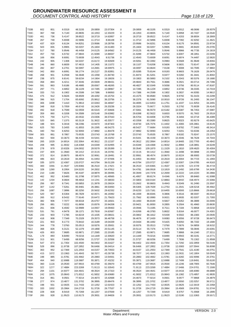
GROUNDWATER RESOURCE ASSESSMENT II DOCUMENT CONTROL AND HISTORY Page 118 of 129
Department: Water Affairs and Forestry
VERSION: 2.0
T33B 602 801 6.0319 48.3155 29.0859 23.07304 0 29.0859 48.3155 6.0319 6.0012 48.0696 28.9379T33C 367 768 5.7140 43.8835 16.1053 12.33229 0 16.1053 43.8835 5.7140 5.6958 43.7437 16.0540T33D 461 736 5.4147 39.8522 18.3719 14.63957 0 18.3719 39.8522 5.4147 5.4203 39.8934 18.3909T33E 267 748 5.6938 42.5896 11.3714 8.66108 0 11.3714 42.5896 5.6938 5.7392 42.9292 11.4621T33F 437 829 6.6134 54.8251 23.9586 19.28756 0 23.9586 54.8251 6.6134 6.6175 54.8591 23.9734T33G 503 835 5.9905 50.0207 25.1604 24.51483 0 25.1604 50.0207 5.9905 5.9691 49.8420 25.0705T33H 517 780 5.9546 46.4459 24.0125 18.64562 0 24.0125 46.4459 5.9546 5.9966 46.7735 24.1819T33J 457 730 6.5732 47.9844 21.9289 14.86937 0 21.9289 47.9844 6.5732 6.6007 48.1851 22.0206T33K 169 856 8.6091 73.6939 12.4543 8.51736 0 12.4543 73.6939 8.6091 8.6974 74.4497 12.5820T34A 242 905 7.1308 64.5337 15.6172 19.92609 1 19.9261 82.3392 9.0983 9.0569 81.9649 19.8355T34B 246 860 6.6839 57.4815 14.1405 18.11072 1 18.1107 73.6208 8.5606 8.5831 73.8147 18.1584T34C 282 807 6.2701 50.5997 14.2691 18.00975 1 18.0097 63.8644 7.9138 7.9008 63.7595 17.9802T34D 342 850 6.6091 56.1774 19.2127 25.92851 1 25.9285 75.8144 8.9193 8.9603 76.1626 26.0476T34E 268 901 6.2558 56.3648 15.1058 21.84740 1 21.8474 81.5201 9.0477 9.0282 81.3441 21.8002T34F 238 875 6.8141 59.6234 14.1904 19.18026 1 19.1803 80.5893 9.2102 9.2043 80.5376 19.1680T34G 358 894 6.4211 57.4046 20.5509 29.98431 1 29.9843 83.7551 9.3686 9.2921 83.0714 29.7396T34H 591 863 5.6186 48.4885 28.6567 48.48265 1 48.4827 82.0349 9.5058 9.3756 80.9114 47.8187T34J 297 771 4.6852 36.1229 10.7285 10.08967 0 10.7285 36.1229 4.6852 4.6736 36.0335 10.7019T34K 333 715 6.1902 44.2599 14.7386 9.96950 0 14.7386 44.2599 6.1902 6.2837 44.9285 14.9612T35A 475 912 6.5626 59.8509 28.4292 43.15754 1 43.1575 90.8580 9.9625 9.9792 91.0103 43.2299T35B 396 915 7.1704 65.6092 25.9812 36.23756 1 36.2376 91.5090 10.0010 9.9726 91.2493 36.1347T35C 306 1008 7.1410 71.9813 22.0263 34.46947 1 34.4695 112.6453 11.1751 11.1037 111.9253 34.2491T35D 348 818 5.7059 46.6743 16.2426 26.33236 1 26.3324 75.6677 9.2503 9.2792 75.9039 26.4145T35E 492 918 6.7599 62.0559 30.5315 47.50606 1 47.5061 96.5570 10.5182 10.5387 96.7453 47.5987T35F 359 860 6.3208 54.3589 19.5148 29.63982 1 29.6398 82.5622 9.6003 9.5070 81.7602 29.3519T35G 575 759 5.2771 40.0532 23.0306 36.57043 1 36.5704 63.6008 8.3795 8.3494 63.3719 36.4389T35H 520 845 7.1375 60.3119 31.3622 43.33577 1 43.3358 83.3380 9.8625 9.9323 83.9279 43.6425T35J 188 924 6.3018 58.2286 10.9470 19.87303 1 19.8730 105.7076 11.4402 11.4065 105.3961 19.8145T35K 625 783 5.3455 41.8553 26.1595 48.54275 1 48.5427 77.6684 9.9193 9.8782 77.3463 48.3414T35L 340 764 6.9253 52.9093 17.9892 11.80478 0 17.9892 52.9093 6.9253 7.0201 53.6336 18.2354T35M 305 861 8.7867 75.6535 23.0743 16.15768 0 23.0743 75.6535 8.7867 8.8182 75.9247 23.1570T36A 462 930 10.3673 96.4159 44.5441 28.43252 0 44.5441 96.4159 10.3673 10.4046 96.7628 44.7044T36B 265 1029 14.8014 152.3064 40.3612 23.12157 0 40.3612 152.3064 14.8014 14.8465 152.7705 40.4842T40A 208 995 11.9032 118.4368 24.6349 23.52955 0 24.6349 118.4368 11.9032 11.8984 118.3891 24.6249T40B 278 979 10.6326 104.0932 28.9379 30.35399 1 30.3540 109.1870 11.1529 11.1810 109.4620 30.4304T40C 237 829 11.3560 94.1412 22.3115 18.23781 0 22.3115 94.1412 11.3560 11.3498 94.0898 22.2993T40D 372 814 10.8670 88.4574 32.9061 19.18491 0 32.9061 88.4574 10.8670 10.9224 88.9083 33.0739T40E 486 823 10.2619 84.4554 41.0453 27.57006 0 41.0453 84.4554 10.2619 10.3004 84.7723 41.1993T40F 335 1070 12.4367 133.0727 44.5794 36.01159 0 44.5794 133.0727 12.4367 12.5307 134.0785 44.9163T40G 300 1055 11.4537 120.8365 36.2510 31.17621 0 36.2510 120.8365 11.4537 11.5235 121.5729 36.4719T51A 328 1260 8.2954 104.5220 34.2832 54.47812 1 54.4781 166.0918 13.1819 13.1492 165.6799 54.3430T51B 210 1180 7.6626 90.4187 18.9879 30.39495 1 30.3949 144.7378 12.2659 12.2222 144.2220 30.2866T51C 462 952 8.5483 81.3798 37.5975 41.49565 1 41.4957 89.8174 9.4346 9.4376 89.8460 41.5088T51D 142 1234 8.0604 99.4653 14.1241 22.58033 1 22.5803 159.0164 12.8863 12.8442 158.4974 22.5066T51E 256 957 8.7341 83.5853 21.3978 23.26024 1 23.2602 90.8603 9.4943 9.5349 91.2490 23.3597T51F 307 1142 7.5261 85.9481 26.3861 39.53050 1 39.5305 128.7639 11.2753 11.2541 128.5218 39.4562T51G 256 1087 7.3896 80.3250 20.5632 29.62332 1 29.6233 115.7161 10.6455 10.6593 115.8666 29.6618T51H 520 947 8.5304 80.7829 42.0071 46.19392 1 46.1939 88.8345 9.3806 9.3516 88.5597 46.0510T51J 265 912 8.5432 77.9140 20.6472 21.75623 1 21.7562 82.0990 9.0021 8.9935 82.0207 21.7355T52A 382 906 7.7077 69.8318 26.6757 33.16501 1 33.1650 86.8194 9.5827 9.5352 86.3889 33.0006T52B 256 881 7.0222 61.8656 15.8376 20.94208 1 20.9421 81.8050 9.2855 9.2504 81.4960 20.8630T52C 261 836 6.4592 53.9989 14.0937 19.09463 1 19.0946 73.1595 8.7511 8.7184 72.8858 19.0232T52D 531 791 4.9478 39.1371 20.7818 24.62687 1 24.6269 46.3783 5.8632 5.8164 46.0077 24.4301T52E 233 903 7.1785 64.8219 15.1035 20.08021 1 20.0802 86.1812 9.5439 9.5502 86.2383 20.0935T52F 418 908 7.7349 70.2329 29.3573 36.46758 1 36.4676 87.2430 9.6083 9.6556 87.6728 36.6473T52G 221 903 8.1773 73.8410 16.3189 19.04339 1 19.0434 86.1692 9.5425 9.6050 86.7332 19.1680T52H 344 778 7.0760 55.0513 18.9376 15.35931 0 18.9376 55.0513 7.0760 7.0676 54.9859 18.9152T52J 368 826 6.3121 52.1379 19.1868 20.51145 1 20.5114 55.7376 6.7479 6.7899 56.0846 20.6391T52K 426 803 7.9685 63.9871 27.2585 22.20185 0 27.2585 63.9871 7.9685 7.9868 64.1340 27.3211T52L 179 893 8.8490 79.0216 14.1449 12.30620 0 14.1449 79.0216 8.8490 8.9943 80.3191 14.3771T52M 313 901 7.6499 68.9256 21.5737 21.52558 0 21.5737 68.9256 7.6499 7.7836 70.1302 21.9508T60A 547 873 11.7354 102.4500 56.0402 35.01627 0 56.0402 102.4500 11.7354 11.7292 102.3959 56.0106T60B 528 896 11.9738 107.2852 56.6466 36.04014 0 56.6466 107.2852 11.9738 12.0083 107.5944 56.8098T60C 363 952 12.7369 121.2553 44.0157 28.73553 0 44.0157 121.2553 12.7369 12.7541 121.4190 44.0751T60D 415 1072 13.1963 141.4643 58.7077 43.26738 0 58.7077 141.4643 13.1963 13.2631 142.1804 59.0049T60E 198 885 11.5781 102.4662 20.2883 13.54931 0 20.2883 102.4662 11.5781 11.6282 102.9096 20.3761T60F 464 940 12.6988 119.3687 55.3871 37.43232 0 55.3871 119.3687 12.6988 12.7499 119.8491 55.6100T60G 360 1116 15.0530 167.9915 60.4769 42.35670 0 60.4769 167.9915 15.0530 15.1246 168.7905 60.7646T60H 322 1277 17.4884 223.3269 71.9113 51.53543 0 71.9113 223.3269 17.4884 17.5466 224.0701 72.1506T60J 294 1101 14.9377 164.4641 48.3524 34.17310 0 48.3524 164.4641 14.9377 15.0416 165.6080 48.6888T60K 242 1075 15.9843 171.8312 41.5832 26.63680 0 41.5832 171.8312 15.9843 16.1382 173.4857 41.9835T70A 314 861 9.0501 77.9214 24.4673 15.42668 0 24.4673 77.9214 9.0501 9.0577 77.9868 24.4879T70B 277 974 13.4877 131.3702 36.3895 20.66476 0 36.3895 131.3702 13.4877 13.5550 132.0257 36.5711T70C 198 931 12.0025 111.7433 22.1252 12.02423 0 22.1252 111.7433 12.0025 12.0625 112.3019 22.2358T70D 333 1002 15.3964 154.2719 51.3726 26.77537 0 51.3726 154.2719 15.3964 15.4569 154.8781 51.5744T70E 228 828 8.5419 70.7269 16.1257 10.07839 0 16.1257 70.7269 8.5419 8.5757 71.0068 16.1895T70F 265 928 11.9523 110.9173 29.3931 15.94826 0 29.3931 110.9173 11.9523 12.0190 111.5363 29.5571

GROUNDWATER RESOURCE ASSESSMENT II DOCUMENT CONTROL AND HISTORY Page 119 of 129
Department: Water Affairs and Forestry
VERSION: 2.0
T70G 269 942 12.6331 119.0038 32.0120 16.82882 0 32.0120 119.0038 12.6331 12.7116 119.7433 32.2109T80A 213 1002 13.4119 134.3872 28.6245 16.77395 0 28.6245 134.3872 13.4119 13.4430 134.6989 28.6909T80B 234 927 11.7432 108.8595 25.4731 15.15801 0 25.4731 108.8595 11.7432 11.8362 109.7216 25.6748T80C 315 794 8.6099 68.3626 21.5342 13.72495 0 21.5342 68.3626 8.6099 8.6836 68.9478 21.7186T80D 280 965 12.0851 116.6212 32.6539 20.04186 0 32.6539 116.6212 12.0851 12.1488 117.2359 32.8261T90A 329 701 6.5991 46.2597 15.2194 8.56110 0 15.2194 46.2597 6.5991 6.6383 46.5345 15.3098T90B 402 966 10.7645 103.9851 41.8020 28.32045 0 41.8020 103.9851 10.7645 10.8057 104.3831 41.9620T90C 367 896 9.4942 85.0680 31.2200 19.86590 0 31.2200 85.0680 9.4942 9.5724 85.7687 31.4771T90D 374 808 8.5251 68.8828 25.7622 14.45054 0 25.7622 68.8828 8.5251 8.5523 69.1026 25.8444T90E 412 899 9.7626 87.7658 36.1595 22.48011 0 36.1595 87.7658 9.7626 9.8569 88.6135 36.5088T90F 282 976 11.7949 115.1182 32.4633 18.90331 0 32.4633 115.1182 11.7949 11.8458 115.6150 32.6034T90G 460 866 9.8600 85.3876 39.2783 21.20076 0 39.2783 85.3876 9.8600 9.8946 85.6872 39.4161U10A 418 1287 9.6997 124.8351 52.1811 74.71658 1 74.7166 178.7478 13.8887 13.8752 178.5738 74.6439U10B 392 1176 9.0957 106.9654 41.9304 59.26348 1 59.2635 151.1824 12.8556 12.8382 150.9772 59.1831U10C 267 1091 8.6911 94.8199 25.3169 35.06644 1 35.0664 131.3350 12.0380 12.0204 131.1426 35.0151U10D 337 999 8.8995 88.9060 29.9613 37.39057 1 37.3906 110.9513 11.1062 11.1243 111.1318 37.4514U10E 327 1034 9.2927 96.0865 31.4203 38.74701 1 38.7470 118.4924 11.4596 11.4699 118.5988 38.7818U10F 379 963 8.9639 86.3224 32.7162 31.76596 0 32.7162 86.3224 8.9639 8.9571 86.2569 32.6914U10G 353 981 8.1480 79.9319 28.2160 32.83714 1 32.8371 93.0231 9.4825 9.5094 93.2872 32.9304U10H 458 924 8.7860 81.1826 37.1816 38.25217 1 38.2522 83.5200 9.0390 9.0627 83.7393 38.3526U10J 505 878 7.8263 68.7149 34.7010 24.72065 0 34.7010 68.7149 7.8263 7.7330 67.8957 34.2873U10K 364 793 5.6815 45.0543 16.3998 13.75649 0 16.3998 45.0543 5.6815 5.6056 44.4524 16.1807U10L 307 758 6.1667 46.7436 14.3503 10.79715 0 14.3503 46.7436 6.1667 6.1720 46.7838 14.3626U10M 280 858 7.8207 67.1016 18.7884 13.68150 0 18.7884 67.1016 7.8207 7.8905 67.7005 18.9561U20A 293 1010 7.8323 79.1062 23.1781 37.83846 1 37.8385 129.1415 12.7863 12.8203 129.4850 37.9391U20B 353 988 7.0888 70.0373 24.7232 32.39203 1 32.3920 91.7621 9.2877 9.2954 91.8386 32.4190U20C 279 932 6.7791 63.1812 17.6276 24.07877 1 24.0788 86.3038 9.2601 9.2749 86.4421 24.1173U20D 338 1040 7.4631 77.6162 26.2343 31.42090 1 31.4209 92.9613 8.9386 8.9409 92.9854 31.4291U20E 390 975 6.7533 65.8447 25.6794 25.36974 0 25.6794 65.8447 6.7533 6.7369 65.6848 25.6171U20F 435 983 6.1393 60.3493 26.2520 29.39338 1 29.3934 67.5710 6.8740 6.8370 67.2077 29.2354U20G 494 895 5.7300 51.2835 25.3340 26.34829 1 26.3483 53.3366 5.9594 5.9518 53.2686 26.3147U20H 220 943 7.4999 70.7241 15.5593 20.56780 1 20.5678 93.4900 9.9141 9.9977 94.2783 20.7412U20J 678 840 7.1140 59.7576 40.5157 31.12879 0 40.5157 59.7576 7.1140 7.1229 59.8324 40.5663U20K 271 949 5.6053 53.1943 14.4157 16.92122 1 16.9212 62.4399 6.5795 6.6027 62.6596 16.9808U20L 328 809 6.3734 51.5608 16.9119 14.28006 0 16.9119 51.5608 6.3734 6.4243 51.9726 17.0470U20M 360 926 9.5061 88.0265 31.6895 21.48121 0 31.6895 88.0265 9.5061 9.5589 88.5154 31.8655U30A 376 967 7.7417 74.8622 28.1482 26.49074 0 28.1482 74.8622 7.7417 7.7775 75.2084 28.2784U30B 221 982 9.4688 92.9836 20.5494 16.37703 0 20.5494 92.9836 9.4688 9.5157 93.4442 20.6512U30C 242 999 7.8146 78.0679 18.8924 18.38412 0 18.8924 78.0679 7.8146 7.8510 78.4315 18.9804U30D 181 986 8.8091 86.8577 15.7212 13.34581 0 15.7212 86.8577 8.8091 8.8507 87.2679 15.7955U30E 290 1019 8.3626 85.2149 24.7123 23.07184 0 24.7123 85.2149 8.3626 8.3905 85.4992 24.7948U40A 317 919 6.3868 58.6947 18.6062 27.27227 1 27.2723 86.0324 9.3615 9.3777 86.1811 27.3194U40B 388 868 5.2609 45.6646 17.7179 18.94926 1 18.9493 48.8383 5.6265 5.5905 48.5255 18.8279U40C 264 879 4.6923 41.2453 10.8888 14.38145 1 14.3815 54.4752 6.1974 6.1885 54.3969 14.3608U40D 267 865 4.9985 43.2370 11.5443 14.00790 1 14.0079 52.4640 6.0652 6.0512 52.3429 13.9755U40E 318 842 5.5033 46.3378 14.7354 16.43994 1 16.4399 51.6979 6.1399 6.1941 52.1543 16.5851U40F 290 841 5.3559 45.0431 13.0625 13.15221 1 13.1522 45.3524 5.3927 5.3675 45.1407 13.0908U40G 253 898 5.4493 48.9347 12.3805 14.00839 1 14.0084 55.3691 6.1658 6.1869 55.5584 14.0563U40H 361 924 6.5285 60.3233 21.7767 23.08481 1 23.0848 63.9469 6.9207 6.9661 64.3668 23.2364U40J 279 996 8.2134 81.8055 22.8237 19.70920 0 22.8237 81.8055 8.2134 8.2630 82.2995 22.9616U50A 298 1056 8.0410 84.9130 25.3041 25.42450 1 25.4245 85.3171 8.0793 8.1095 85.6363 25.5196U60A 105 981 8.8819 87.1314 9.1488 7.38008 0 9.1488 87.1314 8.8819 8.9084 87.3914 9.1761U60B 316 822 7.3362 60.3036 19.0559 14.48583 0 19.0559 60.3036 7.3362 7.2982 59.9912 18.9572U60C 365 773 6.8215 52.7302 19.2465 14.62015 0 19.2465 52.7302 6.8215 6.8209 52.7256 19.2448U60D 185 888 9.9134 88.0310 16.2857 10.18184 0 16.2857 88.0310 9.9134 9.9720 88.5514 16.3820U60E 280 907 8.9320 81.0132 22.6837 16.19987 0 22.6837 81.0132 8.9320 8.9960 81.5937 22.8462U60F 272 967 10.9097 105.4968 28.6951 18.34779 0 28.6951 105.4968 10.9097 11.0060 106.4280 28.9484U70A 114 1040 9.0595 94.2188 10.7409 9.22209 0 10.7409 94.2188 9.0595 9.0354 93.9682 10.7124U70B 272 849 6.6309 56.2963 15.3126 13.46113 0 15.3126 56.2963 6.6309 6.5904 55.9525 15.2191U70C 350 859 7.0846 60.8567 21.2998 18.07990 0 21.2998 60.8567 7.0846 7.0989 60.9796 21.3428U70D 208 938 9.2873 87.1149 18.1199 13.25990 0 18.1199 87.1149 9.2873 9.3541 87.7415 18.2502U70E 87 999 10.4953 104.8480 9.1218 6.44942 0 9.1218 104.8480 10.4953 10.5393 105.2876 9.1600U70F 59 997 10.9009 108.6820 6.4122 4.35259 0 6.4122 108.6820 10.9009 10.9209 108.8814 6.4240U80A 158 1037 10.8758 112.7820 17.8196 12.65810 0 17.8196 112.7820 10.8758 10.9217 113.2580 17.8948U80B 339 801 5.7015 45.6690 15.4818 14.89040 0 15.4818 45.6690 5.7015 5.7367 45.9510 15.5774U80C 202 962 9.3092 89.5545 18.0900 13.55862 0 18.0900 89.5545 9.3092 9.3937 90.3674 18.2542U80D 120 1048 11.1938 117.3110 14.0773 9.84637 0 14.0773 117.3110 11.1938 11.2783 118.1966 14.1836U80E 415 831 6.8524 56.9434 23.6315 19.88883 0 23.6315 56.9434 6.8524 6.9326 57.6099 23.9081U80F 137 935 10.1095 94.5238 12.9498 8.61544 0 12.9498 94.5238 10.1095 10.1667 95.0586 13.0230U80G 261 939 8.9067 83.6339 21.8285 16.57661 0 21.8285 83.6339 8.9067 8.9292 83.8452 21.8836U80H 243 1013 10.1763 103.0859 25.0499 18.45108 0 25.0499 103.0859 10.1763 10.1863 103.1872 25.0745U80J 371 840 6.4667 54.3203 20.1528 18.22771 0 20.1528 54.3203 6.4667 6.4951 54.5588 20.2413U80K 184 950 9.5876 91.0822 16.7591 11.99846 0 16.7591 91.0822 9.5876 9.7216 92.3552 16.9934U80L 107 983 10.3008 101.2569 10.8345 7.55785 0 10.8345 101.2569 10.3008 10.3899 102.1327 10.9282V11A 207 1405 9.6882 136.1192 28.1767 47.18763 1 47.1876 227.9596 16.2249 16.2963 228.9630 47.3953V11B 253 1488 11.0327 164.1666 41.5341 63.85546 1 63.8555 252.3931 16.9619 16.9388 252.0493 63.7685V11C 252 1135 7.8096 88.6390 22.3370 38.86971 1 38.8697 154.2449 13.5899 13.6695 155.1488 39.0975

GROUNDWATER RESOURCE ASSESSMENT II DOCUMENT CONTROL AND HISTORY Page 120 of 129
Department: Water Affairs and Forestry
VERSION: 2.0
V11D 266 894 7.2575 64.8821 17.2586 18.21998 1 18.2200 68.4962 7.6618 7.7449 69.2394 18.4177V11E 193 1178 10.9766 129.3043 24.9557 31.95951 1 31.9595 165.5933 14.0572 14.1379 166.5445 32.1431V11F 161 824 5.7391 47.2902 7.6137 6.41882 0 7.6137 47.2902 5.7391 5.7759 47.5934 7.6625V11G 313 1425 10.9584 156.1572 48.8772 73.93401 1 73.9340 236.2109 16.5762 16.4786 234.8201 73.4987V11H 133 987 10.4365 103.0083 13.7001 11.67065 0 13.7001 103.0083 10.4365 10.5426 104.0555 13.8394V11J 144 830 7.9819 66.2498 9.5400 8.45583 0 9.5400 66.2498 7.9819 8.0768 67.0374 9.6534V11K 247 912 6.1861 56.4172 13.9351 13.27927 0 13.9351 56.4172 6.1861 6.1428 56.0223 13.8375V11L 312 738 6.0696 44.7936 13.9756 9.03327 0 13.9756 44.7936 6.0696 6.0900 44.9442 14.0226V11M 154 742 6.4878 48.1395 7.4135 4.51400 0 7.4135 48.1395 6.4878 6.5049 48.2664 7.4330V12A 307 920 6.3123 58.0732 17.8285 20.34457 1 20.3446 66.2690 7.2031 7.1949 66.1931 20.3213V12B 293 885 6.7668 59.8862 17.5467 16.67723 0 17.5467 59.8862 6.7668 6.7656 59.8756 17.5435V12C 155 800 6.9002 55.2016 8.5562 4.80524 0 8.5562 55.2016 6.9002 6.8809 55.0472 8.5323V12D 236 1014 6.9122 70.0897 16.5412 19.91010 1 19.9101 84.3648 8.3200 8.2921 84.0819 19.8433V12E 325 786 6.0987 47.9358 15.5791 10.30167 0 15.5791 47.9358 6.0987 6.1008 47.9523 15.5845V12F 333 734 6.1624 45.2320 15.0623 8.74840 0 15.0623 45.2320 6.1624 6.1506 45.1454 15.0334V12G 506 740 6.1867 45.7816 23.1655 13.34865 0 23.1655 45.7816 6.1867 6.1740 45.6876 23.1179V13A 232 1279 9.9737 127.5636 29.5948 40.04870 1 40.0487 172.6237 13.4968 13.4627 172.1879 39.9476V13B 294 976 8.9567 87.4174 25.7007 25.15523 0 25.7007 87.4174 8.9567 8.9546 87.3969 25.6947V13C 256 823 7.2900 59.9967 15.3592 15.12198 0 15.3592 59.9967 7.2900 7.2905 60.0008 15.3602V13D 284 814 8.1499 66.3402 18.8406 15.33099 0 18.8406 66.3402 8.1499 8.1892 66.6601 18.9315V13E 281 708 6.3511 44.9658 12.6354 7.38004 0 12.6354 44.9658 6.3511 6.3505 44.9615 12.6342V14A 224 732 5.5776 40.8280 9.1455 6.27972 0 9.1455 40.8280 5.5776 5.5462 40.5982 9.0940V14B 170 714 5.8056 41.4520 7.0468 4.14519 0 7.0468 41.4520 5.8056 5.7505 41.0586 6.9800V14C 195 790 5.8441 46.1684 9.0028 7.19578 0 9.0028 46.1684 5.8441 5.8637 46.3232 9.0330V14D 632 714 4.7898 34.1992 21.6139 16.82460 0 21.6139 34.1992 4.7898 4.7854 34.1678 21.5940V14E 287 761 5.9281 45.1128 12.9474 8.37685 0 12.9474 45.1128 5.9281 5.9152 45.0147 12.9192V20A 267 1025 8.3824 85.9196 22.9405 33.50946 1 33.5095 125.5036 12.2443 12.2829 125.8997 33.6152V20B 190 972 7.4341 72.2595 13.7293 21.57311 1 21.5731 113.5427 11.6813 11.6769 113.4995 21.5649V20C 188 953 6.9965 66.6766 12.5352 20.55006 1 20.5501 109.3088 11.4700 11.5759 110.3183 20.7398V20D 299 857 5.7777 49.5149 14.8050 20.37781 1 20.3778 68.1532 7.9525 8.0101 68.6466 20.5253V20E 599 755 5.6450 42.6198 25.5292 20.59080 0 25.5292 42.6198 5.6450 5.6766 42.8583 25.6721V20F 154 867 6.9205 60.0007 9.2401 11.83731 1 11.8373 76.8657 8.8657 8.9290 77.4144 11.9218V20G 254 759 6.1254 46.4918 11.8089 8.83528 0 11.8089 46.4918 6.1254 6.1570 46.7316 11.8698V20H 603 681 5.5877 38.0522 22.9455 16.68019 0 22.9455 38.0522 5.5877 5.6557 38.5153 23.2247V20J 314 670 6.6911 44.8304 14.0767 7.79520 0 14.0767 44.8304 6.6911 6.6828 44.7748 14.0593V31A 622 916 6.4144 58.7559 36.5462 42.85167 1 42.8517 68.8934 7.5211 7.5174 68.8594 42.8305V31B 505 856 5.9912 51.2847 25.8988 29.41729 1 29.4173 58.2521 6.8051 6.8339 58.4982 29.5416V31C 396 810 6.0891 49.3217 19.5314 20.11452 1 20.1145 50.7942 6.2709 6.2768 50.8421 20.1335V31D 467 790 5.9242 46.8012 21.8562 15.64962 0 21.8562 46.8012 5.9242 5.9022 46.6274 21.7750V31E 834 855 5.9493 50.8665 42.4227 35.29187 0 42.4227 50.8665 5.9493 5.9631 50.9845 42.5211V31F 156 920 5.9642 54.8706 8.5598 8.22481 0 8.5598 54.8706 5.9642 5.9334 54.5873 8.5156V31G 255 762 5.2622 40.0980 10.2250 7.06079 0 10.2250 40.0980 5.2622 5.2454 39.9699 10.1923V31H 129 966 6.7389 65.0978 8.3976 7.93654 0 8.3976 65.0978 6.7389 6.6953 64.6766 8.3433V31J 358 874 6.1574 53.8157 19.2660 15.72067 0 19.2660 53.8157 6.1574 6.1432 53.6916 19.2216V31K 227 796 5.4011 42.9928 9.7594 6.95280 0 9.7594 42.9928 5.4011 5.3775 42.8049 9.7167V32A 195 943 6.7306 63.4696 12.3766 11.08521 0 12.3766 63.4696 6.7306 6.7252 63.4186 12.3666V32B 557 801 5.5590 44.5276 24.8019 18.05772 0 24.8019 44.5276 5.5590 5.5061 44.1039 24.5659V32C 630 730 4.8081 35.0991 22.1125 15.64095 0 22.1125 35.0991 4.8081 4.8054 35.0794 22.1000V32D 590 744 4.8674 36.2135 21.3659 15.44590 0 21.3659 36.2135 4.8674 4.8754 36.2730 21.4011V32E 783 776 5.4360 42.1834 33.0296 23.12950 0 33.0296 42.1834 5.4360 5.4612 42.3789 33.1827V32F 201 739 5.1400 37.9846 7.6349 5.16436 0 7.6349 37.9846 5.1400 5.1423 38.0016 7.6383V32G 544 859 6.2779 53.9272 29.3364 23.37291 0 29.3364 53.9272 6.2779 6.1194 52.5656 28.5957V32H 517 722 4.4800 32.3456 16.7227 12.44683 0 16.7227 32.3456 4.4800 4.4749 32.3088 16.7036V33A 577 745 4.9732 37.0503 21.3780 15.46597 0 21.3780 37.0503 4.9732 4.9741 37.0570 21.3819V33B 407 736 4.9485 36.4210 14.8233 10.55335 0 14.8233 36.4210 4.9485 4.9621 36.5211 14.8641V33C 398 771 5.7724 44.5052 17.7131 12.58545 0 17.7131 44.5052 5.7724 5.8216 44.8845 17.8640V33D 455 737 6.1148 45.0661 20.5051 12.70422 0 20.5051 45.0661 6.1148 6.1358 45.2208 20.5755V40A 372 912 6.5275 59.5308 22.1455 17.69320 0 22.1455 59.5308 6.5275 6.5094 59.3657 22.0841V40B 292 765 5.8108 44.4526 12.9802 9.48387 0 12.9802 44.4526 5.8108 5.7626 44.0839 12.8725V40C 455 839 5.5809 46.8238 21.3048 17.42779 0 21.3048 46.8238 5.5809 5.5917 46.9144 21.3460V40D 333 810 5.1254 41.5157 13.8247 12.50002 0 13.8247 41.5157 5.1254 5.1011 41.3189 13.7592V40E 301 726 4.6793 33.9717 10.2255 9.21382 0 10.2255 33.9717 4.6793 4.6780 33.9623 10.2226V50A 409 764 4.4800 34.2272 13.9989 14.47549 1 14.4755 35.3924 4.6325 4.6510 35.5336 14.5333V50B 384 830 5.6020 46.4966 17.8547 18.06542 1 18.0654 47.0454 5.6681 5.6651 47.0203 18.0558V50C 409 986 7.2339 71.3263 29.1724 30.01836 1 30.0184 73.3945 7.4437 7.4592 73.5477 30.0810V50D 147 1019 7.8600 80.0934 11.7737 11.70233 0 11.7737 80.0934 7.8600 7.8859 80.3573 11.8125V60A 107 891 6.5839 58.6625 6.2769 6.41686 1 6.4169 59.9707 6.7307 6.7370 60.0267 6.4229V60B 552 851 6.5158 55.4495 30.6081 26.01264 0 30.6081 55.4495 6.5158 6.5040 55.3490 30.5527V60C 361 726 5.7183 41.5149 14.9869 8.03917 0 14.9869 41.5149 5.7183 5.7079 41.4394 14.9596V60D 308 850 6.2625 53.2313 16.3952 14.53889 0 16.3952 53.2313 6.2625 6.2621 53.2279 16.3942V60E 747 717 4.9235 35.3015 26.3702 16.08570 0 26.3702 35.3015 4.9235 4.9103 35.2069 26.2995V60F 406 770 6.1065 47.0201 19.0901 12.11071 0 19.0901 47.0201 6.1065 6.1147 47.0832 19.1158V60G 461 680 4.9208 33.4614 15.4257 10.86209 0 15.4257 33.4614 4.9208 4.8953 33.2880 15.3458V60H 355 702 5.4166 38.0245 13.4987 8.28794 0 13.4987 38.0245 5.4166 5.4302 38.1200 13.5326V60J 186 817 6.2510 51.0707 9.4991 7.01241 0 9.4991 51.0707 6.2510 6.2587 51.1336 9.5108V60K 228 691 6.5823 45.4837 10.3703 5.92593 0 10.3703 45.4837 6.5823 6.5533 45.2833 10.3246V70A 281 1172 9.2625 108.5565 30.5044 44.73252 1 44.7325 159.1905 13.5828 13.5624 158.9513 44.6653

GROUNDWATER RESOURCE ASSESSMENT II DOCUMENT CONTROL AND HISTORY Page 121 of 129
Department: Water Affairs and Forestry
VERSION: 2.0
V70B 121 1088 8.7292 94.9737 11.4918 16.78510 1 16.7851 138.7198 12.7500 12.7709 138.9474 16.8126V70C 342 877 6.7857 59.5106 20.3526 23.63738 1 23.6374 69.1151 7.8809 7.8763 69.0752 23.6237V70D 198 811 6.0621 49.1636 9.7344 11.52126 1 11.5213 58.1882 7.1749 7.1954 58.3547 11.5542V70E 105 769 5.3153 40.8747 4.2918 3.79421 0 4.2918 40.8747 5.3153 5.3415 41.0761 4.3130V70F 365 669 4.7173 31.5587 11.5189 8.62963 0 11.5189 31.5587 4.7173 4.7265 31.6203 11.5414V70G 505 665 4.8351 32.1534 16.2375 11.76105 0 16.2375 32.1534 4.8351 4.8524 32.2685 16.2956W11A 445 1061 7.0485 74.7846 33.2791 39.27143 1 39.2714 88.2504 8.3177 8.3419 88.5076 39.3859W11B 127 1052 7.9252 83.3731 10.5884 10.97990 1 10.9799 86.4559 8.2182 8.2494 86.7837 11.0215W11C 382 1103 9.5510 105.3475 40.2428 37.14337 0 40.2428 105.3475 9.5510 9.5725 105.5847 40.3333W12A 623 876 5.0412 44.1609 27.5122 25.16954 0 27.5122 44.1609 5.0412 5.0188 43.9647 27.3900W12B 656 932 5.8876 54.8724 35.9963 33.16033 0 35.9963 54.8724 5.8876 5.9418 55.3776 36.3277W12C 570 848 3.9781 33.7343 19.2285 23.23279 1 23.2328 40.7593 4.8065 4.7961 40.6709 23.1824W12D 569 848 5.0917 43.1776 24.5681 24.83274 1 24.8327 43.6428 5.1466 5.1675 43.8204 24.9338W12E 249 1041 7.6158 79.2805 19.7408 18.48526 0 19.7408 79.2805 7.6158 7.7562 80.7420 20.1048W12F 399 1285 10.6802 137.2406 54.7590 52.00060 0 54.7590 137.2406 10.6802 10.7025 137.5271 54.8733W12G 326 835 4.4634 37.2694 12.1498 13.77407 1 13.7741 42.2518 5.0601 5.1192 42.7453 13.9350W12H 485 1039 8.5883 89.2324 43.2777 35.85239 0 43.2777 89.2324 8.5883 8.7071 90.4668 43.8764W12J 332 1280 10.9913 140.6886 46.7086 40.20015 0 46.7086 140.6886 10.9913 11.0295 141.1776 46.8710W13A 276 1135 8.4592 96.0119 26.4993 28.23930 1 28.2393 102.3163 9.0147 9.1118 103.4189 28.5436W13B 222 1293 10.6972 138.3148 30.7059 30.36398 0 30.7059 138.3148 10.6972 10.7442 138.9225 30.8408W21A 340 879 6.5604 57.6659 19.6064 17.84144 0 19.6064 57.6659 6.5604 6.4904 57.0506 19.3972W21B 580 814 5.6175 45.7265 26.5213 23.06469 0 26.5213 45.7265 5.6175 5.6069 45.6402 26.4713W21C 370 726 3.9901 28.9681 10.7182 9.93691 0 10.7182 28.9681 3.9901 3.9653 28.7881 10.6516W21D 469 721 3.9575 28.5336 13.3822 12.34232 0 13.3822 28.5336 3.9575 3.9594 28.5473 13.3887W21E 416 730 4.2228 30.8264 12.8238 11.08015 0 12.8238 30.8264 4.2228 4.2245 30.8389 12.8290W21F 243 708 4.3055 30.4829 7.4074 5.68165 0 7.4074 30.4829 4.3055 4.3212 30.5941 7.4344W21G 563 730 5.3278 38.8929 21.8967 14.33482 0 21.8967 38.8929 5.3278 5.3580 39.1134 22.0208W21H 433 780 5.2900 41.2620 17.8664 13.52248 0 17.8664 41.2620 5.2900 5.2560 40.9968 17.7516W21J 530 805 4.9582 39.9135 21.1542 19.48702 0 21.1542 39.9135 4.9582 4.9483 39.8338 21.1119W21K 797 758 4.1537 31.4850 25.0936 26.35289 1 26.3529 33.0651 4.3622 4.3633 33.0738 26.3598W21L 533 733 3.4535 25.3142 13.4924 17.28506 1 17.2851 32.4297 4.4242 4.4274 32.4528 17.2974W22A 239 913 6.1364 56.0253 13.3901 12.96149 0 13.3901 56.0253 6.1364 6.1275 55.9441 13.3706W22B 332 816 4.8098 39.2480 13.0303 13.40222 1 13.4022 40.3681 4.9471 4.9353 40.2720 13.3703W22C 186 878 6.0541 53.1550 9.8868 9.11539 0 9.8868 53.1550 6.0541 6.0421 53.0496 9.8672W22D 197 779 5.3356 41.5643 8.1882 6.02667 0 8.1882 41.5643 5.3356 5.3416 41.6111 8.1974W22E 385 1055 5.8166 61.3651 23.6256 29.57574 1 29.5757 76.8201 7.2815 7.2662 76.6584 29.5135W22F 312 803 4.5399 36.4554 11.3741 10.42843 0 11.3741 36.4554 4.5399 4.4960 36.1029 11.2641W22G 249 774 4.2821 33.1435 8.2527 7.54050 0 8.2527 33.1435 4.2821 4.2770 33.1040 8.2429W22H 306 741 4.7257 35.0174 10.7153 8.39216 0 10.7153 35.0174 4.7257 4.7321 35.0649 10.7298W22J 605 722 3.8381 27.7111 16.7652 15.53920 0 16.7652 27.7111 3.8381 3.8340 27.6815 16.7473W22K 476 753 3.6377 27.3919 13.0385 13.64454 1 13.6445 28.6650 3.8068 3.8237 28.7925 13.7052W22L 279 732 3.1862 23.3230 6.5071 8.37120 1 8.3712 30.0043 4.0989 4.0954 29.9783 8.3640W23A 414 833 4.7541 39.6017 16.3951 16.88136 1 16.8814 40.7762 4.8951 4.9508 41.2402 17.0734W23B 193 920 6.3836 58.7291 11.3347 10.52729 0 11.3347 58.7291 6.3836 6.4857 59.6684 11.5160W23C 313 1136 10.3286 117.3329 36.7252 27.85427 0 36.7252 117.3329 10.3286 10.3930 118.0645 36.9542W23D 248 1039 10.0843 104.7759 25.9844 17.64233 0 25.9844 104.7759 10.0843 10.1400 105.3546 26.1279W31A 370 805 5.5943 45.0341 16.6626 14.17194 0 16.6626 45.0341 5.5943 5.6023 45.0985 16.6865W31B 304 796 5.2760 41.9970 12.7671 11.31127 0 12.7671 41.9970 5.2760 5.2847 42.0662 12.7881W31C 172 895 5.9050 52.8498 9.0902 8.62583 0 9.0902 52.8498 5.9050 5.9425 53.1854 9.1479W31D 295 787 5.3767 42.3146 12.4828 10.65815 0 12.4828 42.3146 5.3767 5.3598 42.1816 12.4436W31E 334 713 4.0131 28.6134 9.5569 3.22680 0 9.5569 28.6134 4.0131 3.9997 28.5179 9.5250W31F 583 692 3.4215 23.6768 13.8036 5.16778 0 13.8036 23.6768 3.4215 3.4041 23.5564 13.7334W31G 520 643 3.3708 21.6742 11.2706 3.75983 0 11.2706 21.6742 3.3708 3.3478 21.5264 11.1937W31H 323 651 3.2767 21.3313 6.8900 2.80238 0 6.8900 21.3313 3.2767 3.2537 21.1816 6.8417W31J 553 650 3.5211 22.8872 12.6566 5.13417 0 12.6566 22.8872 3.5211 3.5251 22.9132 12.6710W31K 855 645 3.4151 22.0274 18.8334 7.68200 0 18.8334 22.0274 3.4151 3.4406 22.1919 18.9740W31L 321 662 3.6724 24.3113 7.8039 3.24240 0 7.8039 24.3113 3.6724 3.7110 24.5668 7.8859W32A 418 700 6.2765 43.9355 18.3650 9.32745 0 18.3650 43.9355 6.2765 6.3362 44.3534 18.5397W32B 935 901 10.4356 94.0248 87.9131 38.26248 0 87.9131 94.0248 10.4356 10.4828 94.4500 88.3108W32C 728 686 4.2605 29.2270 21.2773 8.05820 0 21.2773 29.2270 4.2605 4.3267 29.6812 21.6079W32D 267 773 4.1132 31.7950 8.4893 4.59843 0 8.4893 31.7950 4.1132 4.1377 31.9844 8.5398W32E 456 769 4.8659 37.4188 17.0630 7.73951 0 17.0630 37.4188 4.8659 4.8556 37.3396 17.0268W32F 187 783 6.3390 49.6344 9.2816 3.52025 0 9.2816 49.6344 6.3390 6.4465 50.4761 9.4390W32G 648 846 6.4489 54.5577 35.3534 15.44053 0 35.3534 54.5577 6.4489 6.5665 55.5526 35.9981W32H 1276 958 8.9981 86.2018 109.9935 65.71492 0 109.9935 86.2018 8.9981 9.0370 86.5745 110.4690W41A 188 1016 6.6661 67.7276 12.7328 20.79856 1 20.7986 110.6306 10.8888 10.8773 110.5134 20.7765W41B 306 938 7.4358 69.7478 21.3428 29.26208 1 29.2621 95.6277 10.1949 10.1869 95.5531 29.2393W41C 217 927 7.5138 69.6529 15.1147 20.31970 1 20.3197 93.6392 10.1013 10.0822 93.4620 20.2813W41D 238 880 7.3789 64.9343 15.4544 20.33272 1 20.3327 85.4316 9.7081 9.6794 85.1787 20.2725W41E 303 838 6.8115 57.0804 17.2954 23.78342 1 23.7834 78.4931 9.3667 9.3253 78.1460 23.6782W41F 343 823 6.5374 53.8028 18.4544 25.00251 1 25.0025 72.8936 8.8571 8.8431 72.7787 24.9631W41G 96 777 5.9780 46.4491 4.4591 6.36976 1 6.3698 66.3517 8.5395 8.5327 66.2991 6.3647W42A 397 1061 7.8674 83.4731 33.1388 47.10580 1 47.1058 118.6544 11.1833 11.0982 117.7519 46.7475W42B 417 939 7.8576 73.7829 30.7675 39.56837 1 39.5684 94.8882 10.1052 10.0908 94.7526 39.5118W42C 377 1017 9.0228 91.7619 34.5942 41.34658 1 41.3466 109.6726 10.7839 10.7704 109.5350 41.2947W42D 489 887 7.2133 63.9820 31.2872 42.00360 1 42.0036 85.8969 9.6840 9.6589 85.6744 41.8948W42E 232 833 6.5479 54.5440 12.6542 17.91219 1 17.9122 77.2077 9.2686 9.2788 77.2924 17.9318

GROUNDWATER RESOURCE ASSESSMENT II DOCUMENT CONTROL AND HISTORY Page 122 of 129
Department: Water Affairs and Forestry
VERSION: 2.0
W42F 306 832 6.3747 53.0375 16.2295 23.59164 1 23.5916 77.0969 9.2665 9.2536 76.9900 23.5589W42G 248 812 5.9935 48.6672 12.0695 18.35343 1 18.3534 74.0058 9.1140 9.1021 73.9091 18.3294W42H 273 775 5.8199 45.1042 12.3135 18.05013 1 18.0501 66.1177 8.5313 8.5232 66.0548 18.0330W42J 290 756 5.8184 43.9871 12.7563 17.71621 1 17.7162 61.0904 8.0807 8.0870 61.1377 17.7299W42K 416 803 5.7839 46.4447 19.3210 30.36135 1 30.3613 72.9840 9.0889 9.0447 72.6289 30.2136W42L 251 764 5.0924 38.9059 9.7654 16.21706 1 16.2171 64.6098 8.4568 8.4712 64.7200 16.2447W42M 392 747 5.1000 38.0970 14.9340 23.50724 1 23.5072 59.9674 8.0278 8.0299 59.9834 23.5135W43A 248 779 5.6461 43.9831 10.9078 18.57047 1 18.5705 74.8809 9.6124 9.5551 74.4342 18.4597W43B 332 791 5.6312 44.5428 14.7882 25.43148 1 25.4315 76.6008 9.6841 9.6258 76.1401 25.2785W43C 395 736 4.4488 32.7432 12.9336 26.23295 1 26.2330 66.4125 9.0234 8.9786 66.0825 26.1026W43D 262 647 2.7261 17.6379 4.6211 2.56089 0 4.6211 17.6379 2.7261 2.7367 17.7064 4.6391W43E 265 588 3.0239 17.7805 4.7118 1.99838 0 4.7118 17.7805 3.0239 3.0349 17.8452 4.7290W43F 632 655 3.3824 22.1547 14.0018 6.93038 0 14.0018 22.1547 3.3824 3.3529 21.9615 13.8797W44A 255 685 4.2871 29.3666 7.4885 2.92866 0 7.4885 29.3666 4.2871 4.2782 29.3057 7.4729W44B 486 660 3.6223 23.9072 11.6189 5.02254 0 11.6189 23.9072 3.6223 3.6184 23.8814 11.6064W44C 314 632 3.1725 20.0502 6.2958 2.86212 0 6.2958 20.0502 3.1725 3.1729 20.0527 6.2966W44D 236 564 3.2099 18.1038 4.2725 1.56478 0 4.2725 18.1038 3.2099 3.2254 18.1913 4.2931W44E 712 581 3.2713 19.0063 13.5325 5.11049 0 13.5325 19.0063 3.2713 3.2863 19.0934 13.5945W45A 1289 613 2.9030 17.7954 22.9383 11.53873 0 22.9383 17.7954 2.9030 2.9035 17.7985 22.9422W45B 509 620 4.0636 25.1943 12.8239 4.69482 0 12.8239 25.1943 4.0636 4.0952 25.3902 12.9236W51A 624 922 6.9879 64.4284 40.2033 32.11082 0 40.2033 64.4284 6.9879 7.1031 65.4906 40.8661W51B 496 864 7.3634 63.6198 31.5554 20.90060 0 31.5554 63.6198 7.3634 7.3732 63.7044 31.5974W51C 678 903 7.8204 70.6182 47.8791 33.06125 0 47.8791 70.6182 7.8204 7.9564 71.8463 48.7118W51D 527 902 7.5749 68.3256 36.0076 25.62440 0 36.0076 68.3256 7.5749 7.6646 69.1347 36.4340W51E 274 837 6.8055 56.9620 15.6076 21.45026 1 21.4503 78.2856 9.3531 9.2858 77.7221 21.2959W51F 589 874 7.7566 67.7927 39.9299 49.20787 1 49.2079 83.5448 9.5589 9.5687 83.6304 49.2583W51G 420 889 7.7480 68.8797 28.9295 36.01190 1 36.0119 85.7426 9.6448 9.6078 85.4133 35.8736W51H 286 862 6.6837 57.6135 16.4775 23.40130 1 23.4013 81.8227 9.4922 9.4663 81.5995 23.3375W52A 289 836 7.3160 61.1618 17.6757 11.29939 0 17.6757 61.1618 7.3160 7.3236 61.2253 17.6941W52B 336 861 7.1071 61.1921 20.5606 14.16031 0 20.5606 61.1921 7.1071 7.1208 61.3101 20.6002W52C 178 840 7.1511 60.0692 10.6923 7.04758 0 10.6923 60.0692 7.1511 7.1467 60.0323 10.6857W52D 119 854 7.9196 67.6334 8.0484 9.52723 1 9.5272 80.0608 9.3748 9.3608 79.9412 9.5130W53A 548 825 7.6040 62.7330 34.3777 20.72074 0 34.3777 62.7330 7.6040 7.5799 62.5342 34.2687W53B 219 857 8.2174 70.4231 15.4227 9.12776 0 15.4227 70.4231 8.2174 8.1972 70.2500 15.3848W53C 316 913 8.7637 80.0126 25.2840 15.49104 0 25.2840 80.0126 8.7637 8.7637 80.0126 25.2840W53D 315 867 7.9044 68.5311 21.5873 13.52013 0 21.5873 68.5311 7.9044 7.8779 68.3014 21.5149W53E 422 906 8.1953 74.2494 31.3333 37.04381 1 37.0438 87.7815 9.6889 9.6818 87.7171 37.0166W53F 447 904 8.2280 74.3811 33.2484 39.09556 1 39.0956 87.4621 9.6750 9.6832 87.5361 39.1286W53G 382 946 8.1692 77.2806 29.5212 35.95066 1 35.9507 94.1117 9.9484 9.9638 94.2575 36.0064W54A 251 783 7.8409 61.3942 15.4100 8.38061 0 15.4100 61.3942 7.8409 7.8707 61.6276 15.4685W54B 282 846 8.2395 69.7062 19.6571 11.45907 0 19.6571 69.7062 8.2395 8.2582 69.8644 19.7018W54C 107 867 8.1557 70.7099 7.5660 4.62921 0 7.5660 70.7099 8.1557 8.1662 70.8010 7.5757W54D 139 896 8.3501 74.8169 10.3995 12.08232 1 12.0823 86.9232 9.7012 9.7246 87.1324 12.1114W54E 194 963 8.5254 82.0996 15.9273 19.48109 1 19.4811 100.4180 10.4276 10.4128 100.2753 19.4534W54F 268 998 8.8426 88.2491 23.6508 28.68137 1 28.6814 107.0200 10.7234 10.7197 106.9826 28.6713W54G 265 947 6.5888 62.3959 16.5349 26.00225 1 26.0022 98.1217 10.3613 10.4539 98.9984 26.2346W55A 689 767 7.5202 57.6799 39.7415 21.65692 0 39.7415 57.6799 7.5202 7.5198 57.6769 39.7394W55B 218 850 7.9029 67.1747 14.6441 8.91027 0 14.6441 67.1747 7.9029 7.9091 67.2274 14.6556W55C 532 905 8.6333 78.1314 41.5659 48.34939 1 48.3494 90.8823 10.0422 10.0342 90.8095 48.3107W55D 271 902 8.2700 74.5954 20.2154 24.50175 1 24.5018 90.4124 10.0235 10.0218 90.3966 24.4975W55E 161 933 8.8101 82.1982 13.2339 15.35513 1 15.3551 95.3735 10.2222 10.2128 95.2854 15.3410W56A 360 922 9.5504 88.0547 31.6997 66.52144 1 66.5214 184.7818 20.0414 20.0408 184.7762 66.5194W56B 225 979 10.1892 99.7523 22.4443 44.45165 1 44.4517 197.5629 20.1801 20.1053 196.8309 44.2869W56C 253 1165 9.4272 109.8269 27.7862 60.66207 1 60.6621 239.7710 20.5812 20.4847 238.6468 60.3776W56D 166 1034 8.7490 90.4647 15.0171 34.85004 1 34.8500 209.9400 20.3037 20.1904 208.7687 34.6556W56E 186 1129 7.1914 81.1909 15.1015 42.90141 1 42.9014 230.6528 20.4298 20.1844 227.8819 42.3860W56F 199 907 4.9687 45.0661 8.9682 19.00644 1 19.0064 95.5097 10.5303 10.4078 94.3987 18.7854W57A 593 824 4.6606 38.4033 22.7732 50.31814 1 50.3181 84.8535 10.2978 10.2977 84.8530 50.3179W57B 434 784 3.5253 27.6384 11.9950 8.38066 0 11.9950 27.6384 3.5253 3.5225 27.6164 11.9855W57C 575 755 3.4528 26.0686 14.9895 9.85751 0 14.9895 26.0686 3.4528 3.4482 26.0339 14.9695W57D 366 862 5.2281 45.0662 16.4942 33.27562 1 33.2756 90.9170 10.5472 10.5360 90.8203 33.2402W57E 403 701 2.7558 19.3182 7.7852 5.48146 0 7.7852 19.3182 2.7558 2.7145 19.0286 7.6685W57F 223 774 4.7985 37.1404 8.2823 16.63392 1 16.6339 74.5916 9.6372 9.6009 74.3110 16.5713W57G 623 644 2.4421 15.7271 9.7980 6.47226 0 9.7980 15.7271 2.4421 2.4549 15.8096 9.8494W57H 426 710 3.6862 26.1720 11.1493 5.77145 0 11.1493 26.1720 3.6862 3.6776 26.1110 11.1233W57J 522 628 3.8073 23.9098 12.4809 4.84138 0 12.4809 23.9098 3.8073 3.8172 23.9720 12.5134W57K 301 628 3.6429 22.8774 6.8861 2.78884 0 6.8861 22.8774 3.6429 3.6274 22.7801 6.8568W60A 172 1156 10.8534 125.4653 21.5800 41.79314 1 41.7931 242.9833 21.0193 20.9403 242.0699 41.6360W60B 143 1201 9.9884 119.9607 17.1544 36.35252 1 36.3525 254.2134 21.1668 21.0566 252.8898 36.1632W60C 233 1161 7.4912 86.9728 20.2647 56.90731 1 56.9073 244.2374 21.0368 20.8427 241.9837 56.3822W60D 187 937 5.6107 52.5723 9.8310 19.70172 1 19.7017 105.3568 11.2441 11.0042 103.1094 19.2814W60E 134 806 4.9439 39.8478 5.3396 2.77131 0 5.3396 39.8478 4.9439 4.8874 39.3924 5.2786W60F 418 801 5.2769 42.2680 17.6680 8.45229 0 17.6680 42.2680 5.2769 5.2342 41.9259 17.5250W60G 222 912 4.4787 40.8457 9.0678 22.23072 1 22.2307 100.1384 10.9801 10.9309 99.6898 22.1311W60H 365 796 3.7229 29.6343 10.8165 7.67011 0 10.8165 29.6343 3.7229 3.6910 29.3804 10.7238W60J 447 819 4.0237 32.9541 14.7305 10.36519 0 14.7305 32.9541 4.0237 4.0186 32.9123 14.7118W60K 665 825 4.8118 39.6974 26.3987 14.96361 0 26.3987 39.6974 4.8118 4.8006 39.6050 26.3373

GROUNDWATER RESOURCE ASSESSMENT II DOCUMENT CONTROL AND HISTORY Page 123 of 129
Department: Water Affairs and Forestry
VERSION: 2.0
W70A 2589 769 10.1622 78.1473 202.3234 66.16604 0 202.3234 78.1473 10.1622 10.1710 78.2150 202.4986X11A 672 682 6.7061 45.7356 30.7343 9.26850 0 30.7343 45.7356 6.7061 6.6782 45.5453 30.6065X11B 597 714 7.0997 50.6919 30.2630 9.74947 0 30.2630 50.6919 7.0997 7.0959 50.6647 30.2468X11C 319 716 7.5980 54.4017 17.3541 5.26526 0 17.3541 54.4017 7.5980 7.5793 54.2678 17.3114X11D 590 744 7.3194 54.4563 32.1292 30.19549 0 32.1292 54.4563 7.3194 7.3274 54.5159 32.1644X11E 242 760 7.8286 59.4974 14.3984 13.33361 0 14.3984 59.4974 7.8286 7.8310 59.5156 14.4028X11F 183 820 8.6222 70.7020 12.9385 11.38510 0 12.9385 70.7020 8.6222 8.6546 70.9677 12.9871X11G 264 867 9.0686 78.6248 20.7569 29.57657 1 29.5766 112.0325 12.9219 12.9366 112.1603 29.6103X11H 265 951 9.2921 88.3679 23.4175 34.13376 1 34.1338 128.8066 13.5443 13.5336 128.7045 34.1067X11J 186 1040 9.4422 98.1989 18.2650 27.54884 1 27.5488 148.1120 14.2415 14.2306 147.9982 27.5277X11K 211 895 9.1564 81.9498 17.2914 24.80534 1 24.8053 117.5609 13.1353 13.1161 117.3891 24.7691X12A 244 802 7.9632 63.8649 15.5830 18.50986 1 18.5099 75.8601 9.4589 9.4392 75.7024 18.4714X12B 155 834 8.2727 68.9943 10.6941 12.83296 1 12.8330 82.7933 9.9273 9.9308 82.8229 12.8375X12C 186 876 9.1363 80.0340 14.8863 17.17440 1 17.1744 92.3355 10.5406 10.5421 92.3488 17.1769X12D 223 860 9.0229 77.5969 17.3041 10.00809 0 17.3041 77.5969 9.0229 9.0361 77.7105 17.3294X12E 333 889 8.7628 77.9013 25.9411 16.14255 0 25.9411 77.9013 8.7628 8.7546 77.8284 25.9169X12F 313 870 9.7691 84.9912 26.6022 14.42214 0 26.6022 84.9912 9.7691 9.7723 85.0190 26.6110X12G 239 901 9.9910 90.0189 21.5145 11.91122 0 21.5145 90.0189 9.9910 9.9823 89.9405 21.4958X12H 286 922 11.3519 104.6645 29.9341 16.70295 0 29.9341 104.6645 11.3519 11.3609 104.7475 29.9578X12J 296 1158 12.3689 143.2319 42.3966 39.26048 0 42.3966 143.2319 12.3689 12.4132 143.7449 42.5485X12K 286 911 12.1373 110.5708 31.6232 16.12810 0 31.6232 110.5708 12.1373 12.1090 110.3130 31.5495X13A 245 1200 12.7180 152.6160 37.3909 34.06572 0 37.3909 152.6160 12.7180 12.6765 152.1180 37.2689X13B 237 1157 11.3695 131.5451 31.1762 30.71351 0 31.1762 131.5451 11.3695 11.3598 131.4329 31.1496X13C 195 1267 10.8856 137.9206 26.8945 30.14856 1 30.1486 154.6080 12.2027 12.1152 153.4996 29.9324X13D 181 1185 9.5762 113.4780 20.5395 20.64011 1 20.6401 114.0337 9.6231 9.5925 113.6711 20.5745X13E 212 1019 7.4585 76.0021 16.1124 19.32612 1 19.3261 91.1609 8.9461 8.8154 89.8289 19.0437X13F 217 1007 8.4385 84.9757 18.4397 19.38925 1 19.3892 89.3514 8.8730 8.8533 89.1527 19.3461X13G 335 822 7.1651 58.8971 19.7305 6.30239 0 19.7305 58.8971 7.1651 7.0886 58.2683 19.5199X13H 306 742 6.2579 46.4336 14.2087 3.98580 0 14.2087 46.4336 6.2579 6.2340 46.2563 14.1544X13J 828 676 5.5494 37.5139 31.0615 0.22032 0 31.0615 37.5139 5.5494 5.5852 37.7560 31.2619X13K 621 609 3.6450 22.1981 13.7850 0.09957 0 13.7850 22.1981 3.6450 3.7004 22.5354 13.9945X13L 286 605 4.0582 24.5521 7.0219 0.04423 0 7.0219 24.5521 4.0582 4.0410 24.4481 6.9921X14A 141 1244 11.6097 144.4247 20.3639 26.92434 1 26.9243 190.9528 15.3499 15.4467 192.1569 27.0941X14B 185 1229 10.8258 133.0491 24.6141 34.76306 1 34.7631 187.9084 15.2895 15.3254 188.3492 34.8446X14C 166 1098 10.8638 119.2845 19.8012 26.17576 1 26.1758 157.6853 14.3611 14.3719 157.8035 26.1954X14D 129 1138 9.6943 110.3211 14.2314 21.36238 1 21.3624 165.5999 14.5518 14.5173 165.2069 21.3117X14E 177 980 7.8466 76.8967 13.6107 10.31522 0 13.6107 76.8967 7.8466 7.8646 77.0731 13.6419X14F 117 1257 8.9555 112.5706 13.1708 22.68696 1 22.6870 193.9056 15.4261 15.3480 192.9244 22.5722X14G 204 905 6.6117 59.8359 12.2065 9.78277 0 12.2065 59.8359 6.6117 6.5548 59.3209 12.1015X14H 360 752 5.3641 40.3380 14.5217 5.36271 0 14.5217 40.3380 5.3641 5.3242 40.0380 14.4137X21A 265 839 7.5660 63.4787 16.8219 19.48963 1 19.4896 73.5458 8.7659 8.7607 73.5023 19.4781X21B 378 779 7.7395 60.2907 22.7899 24.18784 1 24.1878 63.9890 8.2142 8.2052 63.9185 24.1612X21C 311 833 7.6443 63.6770 19.8036 22.55112 1 22.5511 72.5116 8.7049 8.6917 72.4019 22.5170X21D 219 806 7.6078 61.3189 13.4288 14.55439 1 14.5544 66.4584 8.2455 8.2793 66.7312 14.6141X21E 345 871 9.0442 78.7750 27.1774 43.15525 1 43.1553 125.0877 14.3614 14.4455 125.8203 43.4080X21F 397 757 7.1744 54.3102 21.5612 22.61734 1 22.6173 56.9706 7.5258 7.5364 57.0505 22.6491X21G 347 796 8.0849 64.3558 22.3315 22.16002 0 22.3315 64.3558 8.0849 8.1183 64.6217 22.4237X21H 229 1068 9.7167 103.7744 23.7643 35.07687 1 35.0769 153.1741 14.3421 14.3319 153.0647 35.0518X21J 355 925 9.2774 85.8160 30.4647 40.80185 1 40.8019 114.9348 12.4254 12.4614 115.2680 40.9201X21K 245 1058 10.1504 107.3912 26.3109 36.84123 1 36.8412 150.3724 14.2129 14.2239 150.4889 36.8698X22A 252 999 8.7150 87.0629 21.9398 40.94694 1 40.9469 162.4878 16.2650 16.2739 162.5763 40.9692X22B 227 977 8.9593 87.5324 19.8698 35.61434 1 35.6143 156.8914 16.0585 16.0948 157.2462 35.6949X22C 366 936 8.2679 77.3875 28.3238 20.64861 0 28.3238 77.3875 8.2679 8.2547 77.2640 28.2786X22D 274 1178 8.8191 103.8890 28.4656 42.33756 1 42.3376 154.5166 13.1169 13.0883 154.1802 42.2454X22E 153 1136 8.4969 96.5248 14.7683 22.28806 1 22.2881 145.6736 12.8234 12.8132 145.5580 22.2704X22F 212 940 7.8568 73.8539 15.6570 12.07148 0 15.6570 73.8539 7.8568 7.8422 73.7167 15.6279X22G 107 1106 7.9932 88.4048 9.4593 14.92864 1 14.9286 139.5200 12.6148 12.5652 138.9711 14.8699X22H 200 919 7.4744 68.6897 13.7379 10.83692 0 13.7379 68.6897 7.4744 7.4748 68.6934 13.7387X22J 240 815 7.7486 63.1511 15.1563 10.00673 0 15.1563 63.1511 7.7486 7.7788 63.3972 15.2153X22K 335 867 8.2772 71.7633 24.0407 15.71820 0 24.0407 71.7633 8.2772 8.2780 71.7703 24.0430X23A 127 1101 8.7775 96.6403 12.2733 20.28063 1 20.2806 159.6900 14.5041 14.4716 159.3323 20.2352X23B 229 845 8.0957 68.4087 15.6656 10.04707 0 15.6656 68.4087 8.0957 8.0765 68.2464 15.6284X23C 81 1111 9.4114 104.5607 8.4694 13.17583 1 13.1758 162.6646 14.6413 14.6677 162.9581 13.1996X23D 182 814 7.9988 65.1102 11.8501 17.48927 1 17.4893 96.0949 11.8053 11.9159 96.9954 17.6532X23E 180 1016 10.0103 101.7046 18.3068 16.53805 0 18.3068 101.7046 10.0103 10.1000 102.6160 18.4709X23F 310 820 9.8102 80.4436 24.9375 12.82075 0 24.9375 80.4436 9.8102 9.8828 81.0390 25.1221X23G 225 882 9.4767 83.5845 18.8065 10.95655 0 18.8065 83.5845 9.4767 9.5630 84.3457 18.9778X23H 306 882 9.1280 80.5090 24.6357 14.89903 0 24.6357 80.5090 9.1280 9.1730 80.9059 24.7572X24A 249 721 5.8114 41.9002 10.4331 3.54249 0 10.4331 41.9002 5.8114 5.8023 41.8346 10.4168X24B 335 710 6.2530 44.3963 14.8728 4.41595 0 14.8728 44.3963 6.2530 6.2424 44.3210 14.8475X24C 286 729 6.9400 50.5926 14.4695 4.09617 0 14.4695 50.5926 6.9400 6.9929 50.9782 14.5798X24D 302 816 7.7442 63.1927 19.0842 7.66997 0 19.0842 63.1927 7.7442 7.7875 63.5460 19.1909X24E 526 646 5.2167 33.6999 17.7261 0.00000 0 17.7261 33.6999 5.2167 5.2710 34.0507 17.9106X24F 262 655 4.9364 32.3334 8.4714 0.00000 0 8.4714 32.3334 4.9364 4.8995 32.0917 8.4080X24G 620 595 4.1971 24.9727 15.4831 0.00000 0 15.4831 24.9727 4.1971 4.1945 24.9573 15.4735X24H 769 550 3.7042 20.3731 15.6669 0.00000 0 15.6669 20.3731 3.7042 3.7074 20.3907 15.6804X31A 230 1241 9.7030 120.4142 27.6953 65.67589 1 65.6759 285.5474 23.0095 22.9384 284.6655 65.4731

GROUNDWATER RESOURCE ASSESSMENT II DOCUMENT CONTROL AND HISTORY Page 124 of 129
Department: Water Affairs and Forestry
VERSION: 2.0
X31B 195 1241 8.5059 105.5582 20.5839 55.67949 1 55.6795 285.5359 23.0085 22.9020 284.2138 55.4217X31C 154 1294 8.1434 105.3756 16.2278 46.29487 1 46.2949 300.6160 23.2315 23.2429 300.7631 46.3175X31D 192 945 7.1078 67.1687 12.8964 20.49567 1 20.4957 106.7483 11.2961 11.3439 107.1999 20.5824X31E 214 1252 7.2435 90.6886 19.4074 53.34329 1 53.3433 249.2677 19.9096 19.8183 248.1251 53.0988X31F 94 1334 7.4123 98.8801 9.2947 25.37598 1 25.3760 269.9572 20.2367 20.1108 268.2781 25.2181X31G 169 983 6.1898 60.8457 10.2829 18.37592 1 18.3759 108.7332 11.0614 11.0768 108.8849 18.4016X31H 60 1178 7.9020 93.0856 5.5851 10.04627 1 10.0463 167.4378 14.2137 14.2520 167.8886 10.0733X31J 154 902 7.2588 65.4744 10.0831 14.89172 1 14.8917 96.6995 10.7206 10.7077 96.5835 14.8739X31K 488 679 4.8389 32.8561 16.0338 0.00000 0 16.0338 32.8561 4.8389 4.8350 32.8297 16.0209X31L 304 743 4.4298 32.9134 10.0057 0.00000 0 10.0057 32.9134 4.4298 4.4133 32.7908 9.9684X31M 709 571 3.3545 19.1542 13.5803 0.00000 0 13.5803 19.1542 3.3545 3.3806 19.3032 13.6860X32A 112 1037 6.9883 72.4687 8.1165 12.83854 1 12.8385 114.6298 11.0540 11.0191 114.2681 12.7980X32B 55 973 6.2393 60.7084 3.3390 5.48573 1 5.4857 99.7406 10.2508 10.3255 100.4671 5.5257X32C 233 757 4.1679 31.5510 7.3514 4.38490 0 7.3514 31.5510 4.1679 4.1440 31.3701 7.3092X32D 100 1093 7.1419 78.0610 7.8061 12.46732 1 12.4673 124.6732 11.4065 11.3355 123.8970 12.3897X32E 78 896 6.1799 55.3719 4.3190 7.09837 1 7.0984 91.0047 10.1568 10.0168 89.7505 7.0005X32F 157 726 4.3994 31.9396 5.0145 2.58568 0 5.0145 31.9396 4.3994 4.4172 32.0689 5.0348X32G 336 663 3.5531 23.5571 7.9152 0.00000 0 7.9152 23.5571 3.5531 3.5683 23.6578 7.9490X32H 488 636 3.1759 20.1987 9.8570 0.00000 0 9.8570 20.1987 3.1759 3.1703 20.1631 9.8396X32J 355 588 3.0238 17.7799 6.3119 0.00000 0 6.3119 17.7799 3.0238 3.0302 17.8176 6.3252X33A 600 537 3.4824 18.7005 11.2203 0.00000 0 11.2203 18.7005 3.4824 3.4840 18.7091 11.2254X33B 311 525 2.7703 14.5441 4.5232 0.00000 0 4.5232 14.5441 2.7703 2.7793 14.5913 4.5379X33C 183 485 1.8529 8.9866 1.6445 0.00000 0 1.6445 8.9866 1.8529 1.8466 8.9560 1.6389X33D 350 460 2.9750 13.6850 4.7898 0.00000 0 4.7898 13.6850 2.9750 2.9758 13.6887 4.7910X40A 924 522 2.5973 13.5579 12.5275 0.00000 0 12.5275 13.5579 2.5973 2.5972 13.5574 12.5270X40B 743 481 2.5829 12.4237 9.2308 0.00000 0 9.2308 12.4237 2.5829 2.5862 12.4396 9.2426X40C 941 611 2.8785 17.5876 16.5500 0.00000 0 16.5500 17.5876 2.8785 2.8743 17.5620 16.5258X40D 589 489 2.0802 10.1722 5.9914 0.00000 0 5.9914 10.1722 2.0802 2.0750 10.1468 5.9764 Volume 27239.61 18817.81 30488.37 30518.71

GROUNDWATER RESOURCE ASSESSMENT II DOCUMENT HISTORY AND CONTROL Page 125 of 129
Department: Water Affairs and Forestry
VERSION: 2.0
A.4: Recharge Threshold Values
1 2 3 4 5 6 7 8 9 10
CATNUM MAP RTVRainfall season CATNUM MAP
RTV
Rainfall season CATNUM MAP
RTV
Rainfall season CATNUM MAP
RTV
Rainfall season CATNUM MAP
RTV
Rainfall season CATNUM MAP
RTV
Rainfall season CATNUM MAP
RTV
Rainfall season CATNUM MAP
RTV
Rainfall season CATNUM MAP
RTV
Rainfall season CATNUM MAP
RTV
Rainfall season
A10A 558 162 Summer A31G 583 191 Summer A63A 433 185 Summer B11J 682 152 Summer B42E 645 174 Summer B73B 491 174 Summer C11L 675 156 Summer C24A 584 157 Summer C43B 495 147 Summer C81E 658 140 SummerA10B 529 189 Summer A31H 579 187 Summer A63B 394 162 Summer B11K 684 161 Summer B42F 733 186 Summer B73C 511 192 Summer C11M 637 157 Summer C24B 562 166 Summer C43C 470 159 Summer C81F 892 214 SummerA10C 537 302 Summer A31J 552 194 Summer A63C 378 186 Summer B11L 692 156 Summer B42G 676 178 Summer B73D 502 212 Summer C12A 614 137 Summer C24C 587 160 Summer C43D 465 181 Summer C81G 722 145 SummerA21A 684 203 Summer A32A 547 206 Summer A63D 412 166 Summer B12A 672 168 Summer B42H 591 193 Summer B73E 617 274 Summer C12B 631 136 Summer C24D 584 166 Summer C51A 474 128 Summer C81H 638 166 SummerA21B 672 215 Summer A32B 569 200 Summer A63E 358 227 Summer B12B 697 168 Summer B51A 616 173 Summer B73F 569 260 Summer C12C 605 131 Summer C24E 560 157 Summer C51B 434 110 Summer C81J 612 150 SummerA21C 682 161 Summer A32C 526 208 Summer A71A 468 207 Summer B12C 707 172 Summer B51B 578 174 Summer B73G 533 214 Summer C12D 667 243 Summer C24F 577 149 Summer C51C 419 143 Summer C81K 623 150 SummerA21D 714 175 Summer A32D 533 296 Summer A71B 450 234 Summer B12D 703 175 Summer B51C 529 142 Summer B73H 469 225 Summer C12E 641 166 Summer C24G 581 140 Summer C51D 491 121 Summer C81L 740 168 SummerA21E 707 180 Summer A32E 526 181 Summer A71C 418 177 Summer B12E 697 182 Summer B51E 542 149 Summer B73J 510 216 Summer C12F 635 163 Summer C24H 576 144 Summer C51E 423 148 Summer C81M 662 137 SummerA21F 677 209 Summer A41A 625 246 Summer A71D 390 136 Summer B20A 661 196 Summer B51F 573 196 Summer B81A 1194 440 Summer C12G 640 142 Summer C24J 552 169 Summer C51F 372 116 Summer C82A 670 134 SummerA21G 694 217 Summer A41B 587 240 Summer A71E 421 169 Summer B20B 667 199 Summer B51G 528 161 Summer B81B 1163 547 Summer C12H 618 129 Summer C25A 542 156 Summer C51G 403 125 Summer C82B 660 161 SummerA21H 668 238 Summer A41C 512 207 Summer A71F 400 180 Summer B20C 675 249 Summer B51H 568 156 Summer B81C 880 421 Summer C12J 615 138 Summer C25B 509 151 Summer C51H 396 126 Summer C82C 646 152 SummerA21J 637 224 Summer A41D 492 182 Summer A71G 427 146 Summer B20D 677 195 Summer B52A 475 122 Summer B81D 832 484 Summer C12K 657 169 Summer C25C 522 148 Summer C51J 387 116 Summer C82D 623 148 SummerA21K 651 216 Summer A41E 438 162 Summer A71H 491 204 Summer B20E 657 259 Summer B52B 553 163 Summer B81E 667 559 Summer C12L 648 154 Summer C25D 525 150 Summer C51K 350 119 March-May C82E 666 126 SummerA21L 589 171 Summer A42A 640 288 Summer A71J 396 135 Summer B20F 667 230 Summer B52C 539 243 Summer B81F 544 337 Summer C13A 779 161 Summer C25E 510 137 Summer C51L 350 105 March-May C82F 639 143 SummerA22A 604 183 Summer A42B 660 307 Summer A71K 305 229 Summer B20G 669 174 Summer B52D 498 188 Summer B81G 627 273 Summer C13B 683 165 Summer C25F 481 126 Summer C51M 350 103 March-May C82G 655 140 SummerA22B 599 204 Summer A42C 656 246 Summer A71L 288 264 Summer B20H 671 184 Summer B52E 535 173 Summer B81H 510 331 Summer C13C 724 210 Summer C31A 577 141 Summer C52A 543 139 Summer C82H 614 122 SummerA22C 611 164 Summer A42D 667 254 Summer A72A 465 134 Summer B20J 696 170 Summer B52F 557 270 Summer B81J 502 207 Summer C13D 698 164 Summer C31B 553 145 Summer C52B 563 133 Summer C83A 692 170 SummerA22D 582 163 Summer A42E 605 170 Summer A72B 344 124 Summer B31A 677 208 Summer B52G 518 280 Summer B82A 721 321 Summer C13E 699 151 Summer C31C 566 157 Summer C52C 528 145 Summer C83B 668 156 SummerA22E 597 162 Summer A42F 577 222 Summer A80A 938 365 Summer B31B 640 219 Summer B52H 660 265 Summer B82B 702 268 Summer C13F 692 160 Summer C31D 530 144 Summer C52D 513 144 Summer C83C 663 161 SummerA22F 604 162 Summer A42G 551 178 Summer A80B 659 257 Summer B31C 607 196 Summer B52J 570 277 Summer B82C 712 292 Summer C13G 674 154 Summer C31E 506 139 Summer C52E 481 144 Summer C83D 650 170 SummerA22G 656 162 Summer A42H 518 187 Summer A80C 576 263 Summer B31D 599 201 Summer B60A 1193 309 Summer B82D 623 295 Summer C13H 628 141 Summer C31F 477 132 Summer C52F 514 127 Summer C83E 654 147 SummerA22H 658 168 Summer A42J 428 179 Summer A80D 622 260 Summer B31E 588 183 Summer B60B 1026 411 Summer B82E 656 254 Summer C21A 674 182 Summer C32A 449 154 Summer C52G 481 130 Summer C83F 637 134 SummerA22J 600 169 Summer A50A 654 197 Summer A80E 622 314 Summer B31F 568 165 Summer B60C 1352 378 Summer B82F 676 321 Summer C21B 697 156 Summer C32B 434 153 Summer C52H 455 146 Summer C83G 647 144 SummerA23A 698 208 Summer A50B 599 223 Summer A80F 388 186 Summer B31G 604 170 Summer B60D 1004 366 Summer B82G 524 330 Summer C21C 674 177 Summer C32C 460 149 Summer C52J 456 161 Summer C83H 646 135 SummerA23B 645 162 Summer A50C 593 195 Summer A80G 333 232 Summer B31H 575 171 Summer B60E 1027 259 Summer B82H 516 257 Summer C21D 698 159 Summer C32D 442 141 Summer C52K 414 139 Summer C83J 641 140 SummerA23C 574 162 Summer A50D 558 210 Summer A80H 621 355 Summer B31J 552 152 Summer B60F 766 240 Summer B82J 540 184 Summer C21E 691 178 Summer C33A 432 112 Summer C52L 377 118 March-May C83K 635 131 SummerA23D 706 233 Summer A50E 517 208 Summer A80J 292 250 Summer B32A 691 185 Summer B60G 681 248 Summer B83A 515 203 Summer C21F 704 165 Summer C33B 422 128 Summer C60A 625 134 Summer C83L 641 143 SummerA23E 674 231 Summer A50F 496 193 Summer A91A 696 401 Summer B32B 698 187 Summer B60H 778 296 Summer B83B 596 178 Summer C21G 667 156 Summer C33C 397 112 Summer C60B 610 174 Summer C83M 639 141 SummerA23F 596 180 Summer A50G 435 220 Summer A91B 620 286 Summer B32C 664 185 Summer B60J 607 288 Summer B83C 539 172 Summer C22A 695 156 Summer C41A 598 120 Summer C60C 571 159 Summer C91A 464 140 SummerA23G 591 193 Summer A50H 407 220 Summer A91C 866 396 Summer B32D 626 189 Summer B71A 674 296 Summer B83D 552 193 Summer C22B 691 221 Summer C41B 598 139 Summer C60D 550 164 Summer C91B 433 143 SummerA23H 600 219 Summer A50J 391 236 Summer A91D 1287 514 Summer B32E 668 208 Summer B71B 577 260 Summer B83E 587 204 Summer C22C 684 167 Summer C41C 595 142 Summer C60E 557 139 Summer C91C 430 143 SummerA23J 585 193 Summer A61A 629 251 Summer A91E 1078 610 Summer B32F 659 188 Summer B71C 858 312 Summer B90A 465 283 Summer C22D 701 173 Summer C41D 549 133 Summer C60F 556 157 Summer C91D 397 119 SummerA23K 606 212 Summer A61B 618 227 Summer A91F 662 466 Summer B32G 639 188 Summer B71D 686 283 Summer B90B 470 352 Summer C22E 669 137 Summer C41E 519 124 Summer C60G 537 164 Summer C91E 371 101 SummerA23L 604 194 Summer A61C 608 196 Summer A91G 950 594 Summer B32H 610 181 Summer B71E 591 200 Summer B90C 498 327 Summer C22F 655 136 Summer C41F 496 123 Summer C60H 513 164 Summer C92A 367 90 SummerA24A 599 171 Summer A61D 612 190 Summer A91H 722 453 Summer B32J 589 184 Summer B71F 800 270 Summer B90D 471 300 Summer C22G 613 133 Summer C41G 516 146 Summer C60J 548 151 Summer C92B 331 93 SummerA24B 617 212 Summer A61E 593 164 Summer A91J 450 287 Summer B41A 714 174 Summer B71G 845 254 Summer B90E 466 284 Summer C22H 639 146 Summer C41H 500 147 Summer C70A 627 127 Summer C92C 326 101 March-MayA24C 589 182 Summer A61F 597 167 Summer A91K 373 225 Summer B41B 705 215 Summer B71H 615 249 Summer B90F 539 268 Summer C22J 633 181 Summer C41J 495 155 Summer C70B 612 163 Summer D11A 1190 209 SummerA24D 600 184 Summer A61G 585 196 Summer A92A 997 560 Summer B41C 694 221 Summer B71J 459 207 Summer B90G 535 218 Summer C22K 644 158 Summer C42A 633 141 Summer C70C 615 149 Summer D11B 1026 203 SummerA24E 592 164 Summer A61H 636 216 Summer A92B 711 401 Summer B41D 652 194 Summer B72A 713 467 Summer B90H 538 197 Summer C23A 612 148 Summer C42B 582 131 Summer C70D 586 153 Summer D11C 1058 193 SummerA24F 602 216 Summer A61J 631 217 Summer A92C 423 294 Summer B41E 616 168 Summer B72B 512 269 Summer C11A 743 161 Summer C23B 619 171 Summer C42C 626 141 Summer C70E 578 182 Summer D11D 914 207 SummerA24G 645 256 Summer A62A 610 198 Summer A92D 301 288 Summer B41F 676 209 Summer B72C 485 217 Summer C11B 705 163 Summer C23C 609 163 Summer C42D 556 147 Summer C70F 574 159 Summer D11E 842 182 SummerA24H 639 240 Summer A62B 529 230 Summer B11A 699 148 Summer B41G 650 186 Summer B72D 468 165 Summer C11C 765 164 Summer C23D 664 175 Summer C42E 565 132 Summer C70G 577 154 Summer D11F 951 172 SummerA24J 538 219 Summer A62C 478 202 Summer B11B 687 172 Summer B41H 621 170 Summer B72E 770 630 Summer C11D 702 166 Summer C23E 631 159 Summer C42F 567 156 Summer C70H 568 167 Summer D11G 879 222 SummerA31A 602 174 Summer A62D 489 233 Summer B11C 673 172 Summer B41J 598 178 Summer B72F 934 427 Summer C11E 697 156 Summer C23F 605 156 Summer C42G 549 138 Summer C70J 575 165 Summer D11H 852 211 SummerA31B 607 184 Summer A62E 460 183 Summer B11D 671 188 Summer B41K 626 220 Summer B72G 630 682 Summer C11F 705 155 Summer C23G 597 145 Summer C42H 540 155 Summer C70K 565 179 Summer D11J 774 184 SummerA31C 546 155 Summer A62F 478 211 Summer B11E 682 242 Summer B42A 773 189 Summer B72H 614 454 Summer C11G 659 161 Summer C23H 604 174 Summer C42J 530 158 Summer C81A 882 203 Summer D11K 759 189 SummerA31D 566 155 Summer A62G 437 231 Summer B11F 692 165 Summer B42B 879 219 Summer B72J 594 374 Summer C11H 664 195 Summer C23J 620 169 Summer C42K 521 132 Summer C81B 763 170 Summer D12A 627 168 SummerA31E 597 198 Summer A62H 439 178 Summer B11G 693 154 Summer B42C 729 196 Summer B72K 495 184 Summer C11J 658 149 Summer C23K 607 177 Summer C42L 506 160 Summer C81C 730 219 Summer D12B 720 187 SummerA31F 591 200 Summer A62J 450 192 Summer B11H 695 183 Summer B42D 1002 245 Summer B73A 957 395 Summer C11K 633 174 Summer C23L 612 168 Summer C43A 483 119 Summer C81D 735 218 Summer D12C 638 183 Summer
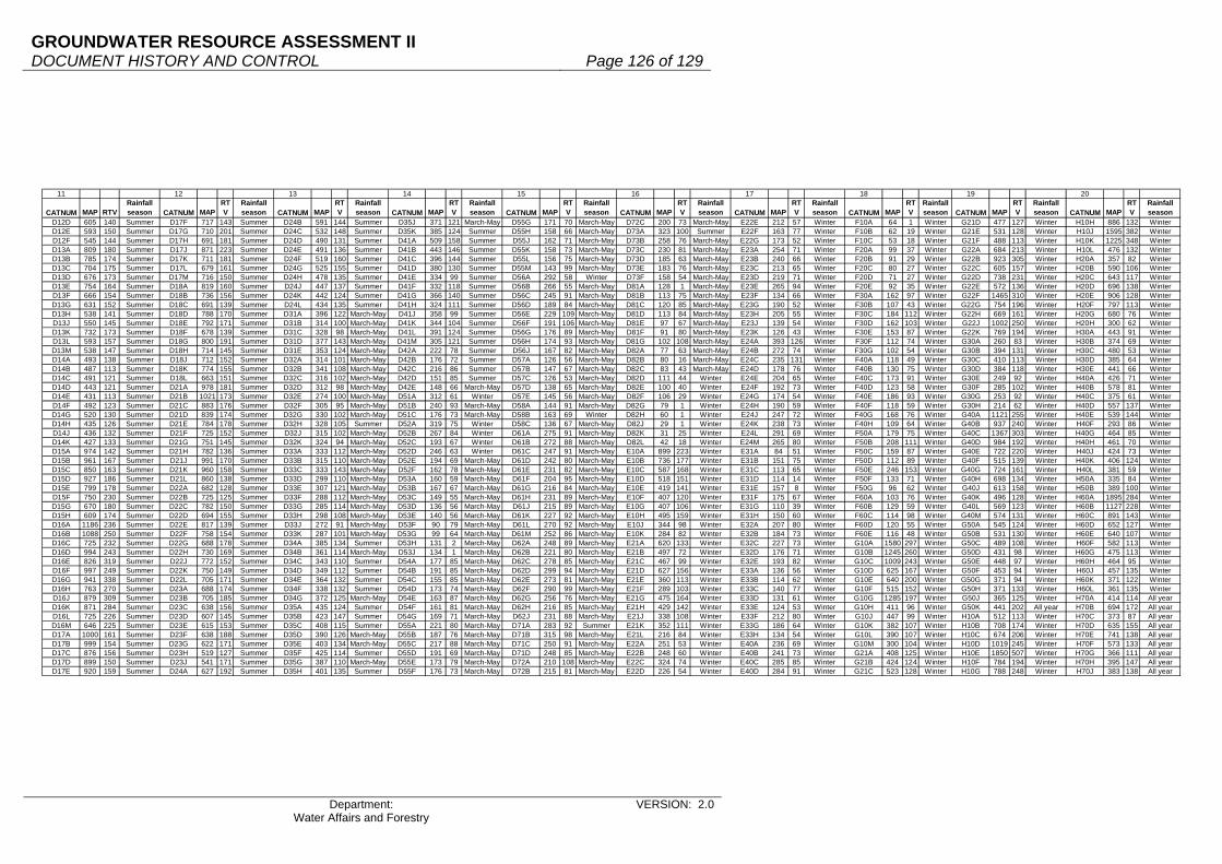
GROUNDWATER RESOURCE ASSESSMENT II DOCUMENT HISTORY AND CONTROL Page 126 of 129
Department: Water Affairs and Forestry
VERSION: 2.0
11 12 13 14 15 16 17 18 19 20
CATNUM MAP RTVRainfall season CATNUM MAP
RTV
Rainfall season CATNUM MAP
RTV
Rainfall season CATNUM MAP
RTV
Rainfall season CATNUM MAP
RTV
Rainfall season CATNUM MAP
RTV
Rainfall season CATNUM MAP
RTV
Rainfall season CATNUM MAP
RTV
Rainfall season CATNUM MAP
RTV
Rainfall season CATNUM MAP
RTV
Rainfall season
D12D 605 140 Summer D17F 717 143 Summer D24B 591 144 Summer D35J 371 121 March-May D55G 171 70 March-May D72C 200 73 March-May E22E 212 57 Winter F10A 64 1 Winter G21D 477 127 Winter H10H 886 132 WinterD12E 593 150 Summer D17G 710 201 Summer D24C 532 148 Summer D35K 385 124 Summer D55H 158 66 March-May D73A 323 100 Summer E22F 163 77 Winter F10B 62 19 Winter G21E 531 128 Winter H10J 1595 382 WinterD12F 545 144 Summer D17H 691 181 Summer D24D 490 131 Summer D41A 509 158 Summer D55J 162 71 March-May D73B 258 76 March-May E22G 173 52 Winter F10C 53 18 Winter G21F 488 113 Winter H10K 1225 348 WinterD13A 809 180 Summer D17J 871 223 Summer D24E 491 136 Summer D41B 443 146 Summer D55K 158 73 March-May D73C 230 81 March-May E23A 254 71 Winter F20A 99 37 Winter G22A 684 213 Winter H10L 476 132 WinterD13B 785 174 Summer D17K 711 181 Summer D24F 519 160 Summer D41C 396 144 Summer D55L 156 75 March-May D73D 185 63 March-May E23B 240 66 Winter F20B 91 29 Winter G22B 923 305 Winter H20A 357 82 WinterD13C 704 175 Summer D17L 679 161 Summer D24G 525 155 Summer D41D 380 130 Summer D55M 143 99 March-May D73E 183 76 March-May E23C 213 65 Winter F20C 80 27 Winter G22C 605 157 Winter H20B 590 106 WinterD13D 676 173 Summer D17M 716 150 Summer D24H 478 135 Summer D41E 334 99 Summer D56A 292 58 Winter D73F 158 54 March-May E23D 219 71 Winter F20D 71 27 Winter G22D 738 231 Winter H20C 643 117 WinterD13E 754 164 Summer D18A 819 160 Summer D24J 447 137 Summer D41F 332 118 Summer D56B 266 55 March-May D81A 128 1 March-May E23E 265 94 Winter F20E 92 35 Winter G22E 572 136 Winter H20D 696 138 WinterD13F 666 154 Summer D18B 736 156 Summer D24K 442 124 Summer D41G 366 140 Summer D56C 245 91 March-May D81B 113 75 March-May E23F 134 66 Winter F30A 162 97 Winter G22F 1465 310 Winter H20E 906 128 WinterD13G 631 152 Summer D18C 691 139 Summer D24L 434 135 Summer D41H 324 111 Summer D56D 189 84 March-May D81C 120 85 March-May E23G 190 52 Winter F30B 107 43 Winter G22G 754 196 Winter H20F 797 113 WinterD13H 538 141 Summer D18D 788 170 Summer D31A 396 122 March-May D41J 358 99 Summer D56E 229 109 March-May D81D 113 84 March-May E23H 205 55 Winter F30C 184 112 Winter G22H 669 161 Winter H20G 680 76 WinterD13J 550 145 Summer D18E 792 171 Summer D31B 314 100 March-May D41K 344 104 Summer D56F 191 106 March-May D81E 97 67 March-May E23J 139 54 Winter F30D 162 103 Winter G22J 1002 250 Winter H20H 300 62 WinterD13K 732 173 Summer D18F 678 139 Summer D31C 328 98 March-May D41L 391 124 Summer D56G 176 89 March-May D81F 91 80 March-May E23K 126 43 Winter F30E 153 87 Winter G22K 769 194 Winter H30A 443 91 WinterD13L 593 157 Summer D18G 800 191 Summer D31D 377 143 March-May D41M 305 121 Summer D56H 174 93 March-May D81G 102 108 March-May E24A 393 126 Winter F30F 112 74 Winter G30A 260 83 Winter H30B 374 69 WinterD13M 538 147 Summer D18H 714 145 Summer D31E 353 124 March-May D42A 222 78 Summer D56J 167 82 March-May D82A 77 63 March-May E24B 272 74 Winter F30G 102 54 Winter G30B 394 131 Winter H30C 480 53 WinterD14A 493 138 Summer D18J 712 152 Summer D32A 314 101 March-May D42B 176 72 Summer D57A 126 56 March-May D82B 80 16 March-May E24C 235 131 Winter F40A 118 49 Winter G30C 410 113 Winter H30D 385 64 WinterD14B 487 113 Summer D18K 774 155 Summer D32B 341 108 March-May D42C 216 86 Summer D57B 147 67 March-May D82C 83 43 March-May E24D 178 76 Winter F40B 130 75 Winter G30D 384 118 Winter H30E 441 66 WinterD14C 491 121 Summer D18L 663 151 Summer D32C 316 102 March-May D42D 151 85 Summer D57C 126 53 March-May D82D 111 44 Winter E24E 204 65 Winter F40C 173 91 Winter G30E 249 92 Winter H40A 426 71 WinterD14D 443 121 Summer D21A 978 181 Summer D32D 312 98 March-May D42E 148 66 March-May D57D 138 65 March-May D82E 100 40 Winter E24F 192 73 Winter F40D 123 58 Winter G30F 285 102 Winter H40B 578 81 WinterD14E 431 113 Summer D21B 1021 173 Summer D32E 274 100 March-May D51A 312 61 Winter D57E 145 56 March-May D82F 106 29 Winter E24G 174 54 Winter F40E 186 93 Winter G30G 253 92 Winter H40C 375 61 WinterD14F 492 123 Summer D21C 883 176 Summer D32F 305 95 March-May D51B 240 93 March-May D58A 144 91 March-May D82G 79 1 Winter E24H 190 59 Winter F40F 118 59 Winter G30H 214 62 Winter H40D 557 137 WinterD14G 520 130 Summer D21D 839 174 Summer D32G 330 102 March-May D51C 176 73 March-May D58B 163 69 Winter D82H 60 1 Winter E24J 247 72 Winter F40G 168 76 Winter G40A 1121 255 Winter H40E 539 144 WinterD14H 435 126 Summer D21E 784 178 Summer D32H 328 105 Summer D52A 319 75 Winter D58C 136 67 March-May D82J 29 1 Winter E24K 238 73 Winter F40H 109 64 Winter G40B 937 240 Winter H40F 293 86 WinterD14J 436 132 Summer D21F 725 152 Summer D32J 315 102 March-May D52B 267 84 Winter D61A 275 91 March-May D82K 31 25 Winter E24L 291 69 Winter F50A 179 75 Winter G40C 1367 303 Winter H40G 464 85 WinterD14K 427 133 Summer D21G 751 145 Summer D32K 324 94 March-May D52C 193 67 Winter D61B 272 88 March-May D82L 42 18 Winter E24M 265 80 Winter F50B 208 111 Winter G40D 984 192 Winter H40H 461 70 WinterD15A 974 142 Summer D21H 782 136 Summer D33A 333 112 March-May D52D 246 63 Winter D61C 247 91 March-May E10A 899 223 Winter E31A 84 51 Winter F50C 159 87 Winter G40E 722 220 Winter H40J 424 73 WinterD15B 961 167 Summer D21J 991 170 Summer D33B 315 110 March-May D52E 194 69 March-May D61D 242 80 March-May E10B 736 177 Winter E31B 151 75 Winter F50D 112 89 Winter G40F 515 139 Winter H40K 406 124 WinterD15C 850 163 Summer D21K 960 158 Summer D33C 333 143 March-May D52F 162 78 March-May D61E 231 82 March-May E10C 587 168 Winter E31C 113 65 Winter F50E 246 153 Winter G40G 724 161 Winter H40L 381 59 WinterD15D 927 186 Summer D21L 860 138 Summer D33D 299 110 March-May D53A 160 59 March-May D61F 204 95 March-May E10D 518 151 Winter E31D 114 14 Winter F50F 133 71 Winter G40H 698 134 Winter H50A 335 84 WinterD15E 799 178 Summer D22A 682 128 Summer D33E 307 121 March-May D53B 167 67 March-May D61G 216 84 March-May E10E 419 141 Winter E31E 157 8 Winter F50G 96 62 Winter G40J 613 158 Winter H50B 389 100 WinterD15F 750 230 Summer D22B 725 125 Summer D33F 288 112 March-May D53C 149 55 March-May D61H 231 89 March-May E10F 407 120 Winter E31F 175 67 Winter F60A 103 76 Winter G40K 496 128 Winter H60A 1895 284 WinterD15G 670 180 Summer D22C 782 150 Summer D33G 285 114 March-May D53D 136 56 March-May D61J 215 89 March-May E10G 407 106 Winter E31G 110 39 Winter F60B 129 59 Winter G40L 569 123 Winter H60B 1127 228 WinterD15H 609 174 Summer D22D 694 155 Summer D33H 298 108 March-May D53E 140 56 March-May D61K 227 92 March-May E10H 495 159 Winter E31H 150 60 Winter F60C 114 98 Winter G40M 574 131 Winter H60C 891 143 WinterD16A 1186 236 Summer D22E 817 139 Summer D33J 272 91 March-May D53F 90 79 March-May D61L 270 92 March-May E10J 344 98 Winter E32A 207 80 Winter F60D 120 55 Winter G50A 545 124 Winter H60D 652 127 WinterD16B 1088 250 Summer D22F 758 154 Summer D33K 287 101 March-May D53G 99 64 March-May D61M 252 86 March-May E10K 284 82 Winter E32B 184 73 Winter F60E 116 48 Winter G50B 531 130 Winter H60E 640 107 WinterD16C 725 232 Summer D22G 688 178 Summer D34A 385 134 Summer D53H 131 2 March-May D62A 248 89 March-May E21A 620 133 Winter E32C 227 73 Winter G10A 1580 297 Winter G50C 489 108 Winter H60F 582 113 WinterD16D 994 243 Summer D22H 730 169 Summer D34B 361 114 March-May D53J 134 1 March-May D62B 221 80 March-May E21B 497 72 Winter E32D 176 71 Winter G10B 1245 260 Winter G50D 431 98 Winter H60G 475 113 WinterD16E 826 319 Summer D22J 772 152 Summer D34C 343 110 Summer D54A 177 85 March-May D62C 278 85 March-May E21C 467 99 Winter E32E 193 82 Winter G10C 1009 243 Winter G50E 448 97 Winter H60H 464 95 WinterD16F 997 249 Summer D22K 750 149 Summer D34D 349 112 Summer D54B 191 85 March-May D62D 299 94 March-May E21D 627 156 Winter E33A 136 56 Winter G10D 625 167 Winter G50F 453 94 Winter H60J 457 135 WinterD16G 941 338 Summer D22L 705 171 Summer D34E 364 132 Summer D54C 155 85 March-May D62E 273 81 March-May E21E 360 113 Winter E33B 114 62 Winter G10E 640 200 Winter G50G 371 94 Winter H60K 371 122 WinterD16H 763 270 Summer D23A 688 174 Summer D34F 338 132 Summer D54D 173 74 March-May D62F 290 99 March-May E21F 289 103 Winter E33C 140 77 Winter G10F 515 152 Winter G50H 371 133 Winter H60L 361 135 WinterD16J 879 309 Summer D23B 705 185 Summer D34G 372 125 March-May D54E 163 87 March-May D62G 256 76 March-May E21G 475 164 Winter E33D 131 61 Winter G10G 1285 197 Winter G50J 365 125 Winter H70A 414 114 All yearD16K 871 284 Summer D23C 638 156 Summer D35A 435 124 Summer D54F 161 81 March-May D62H 216 85 March-May E21H 429 142 Winter E33E 124 53 Winter G10H 411 96 Winter G50K 441 202 All year H70B 694 172 All yearD16L 725 226 Summer D23D 607 145 Summer D35B 423 147 Summer D54G 169 71 March-May D62J 231 88 March-May E21J 338 108 Winter E33F 212 80 Winter G10J 447 99 Winter H10A 512 113 Winter H70C 373 87 All yearD16M 646 225 Summer D23E 615 153 Summer D35C 408 115 Summer D55A 221 80 March-May D71A 283 92 Summer E21K 352 111 Winter E33G 186 64 Winter G10K 382 107 Winter H10B 708 174 Winter H70D 635 155 All yearD17A 1000 161 Summer D23F 638 188 Summer D35D 390 126 March-May D55B 187 76 March-May D71B 315 98 March-May E21L 216 84 Winter E33H 134 54 Winter G10L 390 107 Winter H10C 674 206 Winter H70E 741 138 All yearD17B 999 154 Summer D23G 622 171 Summer D35E 403 134 March-May D55C 217 88 March-May D71C 250 91 March-May E22A 251 53 Winter E40A 236 69 Winter G10M 300 104 Winter H10D 1019 245 Winter H70F 573 133 All yearD17C 876 156 Summer D23H 519 127 Summer D35F 425 114 Summer D55D 191 69 March-May D71D 248 85 March-May E22B 248 60 Winter E40B 241 73 Winter G21A 408 125 Winter H10E 1850 507 Winter H70G 366 111 All yearD17D 899 150 Summer D23J 541 171 Summer D35G 387 110 March-May D55E 173 79 March-May D72A 210 108 March-May E22C 324 74 Winter E40C 285 85 Winter G21B 424 124 Winter H10F 784 194 Winter H70H 395 147 All yearD17E 920 159 Summer D24A 627 192 Summer D35H 401 135 Summer D55F 176 73 March-May D72B 215 81 March-May E22D 226 54 Winter E40D 284 91 Winter G21C 523 128 Winter H10G 788 248 Winter H70J 383 138 All year

GROUNDWATER RESOURCE ASSESSMENT II DOCUMENT HISTORY AND CONTROL Page 127 of 129
Department: Water Affairs and Forestry
VERSION: 2.0
21 22 23 24 25 26 27 28 29 30
CATNUM MAP RTVRainfall season CATNUM MAP
RTV
Rainfall season CATNUM MAP
RTV
Rainfall season CATNUM MAP
RTV
Rainfall season CATNUM MAP
RTV
Rainfall season CATNUM MAP
RTV
Rainfall season CATNUM MAP
RTV
Rainfall season CATNUM MAP
RTV
Rainfall season CATNUM MAP
RTV
Rainfall season CATNUM MAP
RTV
Rainfall season
H70K 458 115 All year J22J 187 83 March-May J40B 431 94 All year L11G 195 81 March-May L90B 597 172 All year P10E 493 149 All year Q60A 499 111 March-May R20F 675 285 Summer S40F 610 193 Summer T31C 830 200 SummerH80A 597 179 All year J22K 151 73 March-May J40C 521 111 All year L12A 159 84 March-May L90C 607 182 All year P10F 557 157 All year Q60B 506 122 March-May R20G 812 436 Summer S50A 730 186 Summer T31D 736 161 SummerH80B 792 256 All year J23A 127 74 March-May J40D 446 88 All year L12B 192 110 March-May M10A 533 218 All year P10G 550 177 All year Q60C 449 132 March-May R30A 866 182 Summer S50B 818 187 Summer T31E 756 170 SummerH80C 479 129 All year J23B 147 58 March-May J40E 440 112 All year L12C 152 101 March-May M10B 557 171 All year P20A 715 181 All year Q70A 427 116 March-May R30B 793 176 Summer S50C 669 167 Summer T31F 713 162 SummerH80D 412 107 All year J23C 124 68 March-May K10A 450 119 All year L12D 170 103 March-May M10C 565 176 All year P20B 635 173 All year Q70B 375 100 March-May R30C 688 181 Summer S50D 707 170 Summer T31G 801 170 SummerH80E 431 95 All year J23D 178 64 All year K10B 446 106 All year L21A 244 77 March-May M10D 471 130 All year P30A 623 152 All year Q70C 363 107 March-May R30D 785 249 Summer S50E 783 206 Summer T31H 808 168 SummerH80F 533 103 All year J23E 329 151 All year K10C 493 136 All year L21B 250 96 March-May M20A 660 164 All year P30B 559 142 All year Q80A 421 122 March-May R30E 671 210 Summer S50F 700 187 Summer T31J 807 183 SummerH90A 645 172 All year J23F 194 82 March-May K10D 454 130 All year L21C 300 99 March-May M20B 725 152 All year P30C 536 177 All year Q80B 407 96 March-May R30F 793 358 Summer S50G 677 168 Summer T32A 804 176 SummerH90B 664 166 All year J23G 98 17 March-May K10E 679 180 All year L21D 367 105 March-May M30A 451 155 All year P40A 635 164 All year Q80C 415 106 March-May R40A 765 384 Summer S50H 635 163 Summer T32B 814 156 SummerH90C 467 110 All year J23H 199 74 March-May K10F 502 143 All year L21E 289 100 March-May M30B 434 129 All year P40B 570 168 All year Q80D 493 141 March-May R40B 609 184 Summer S50J 668 176 Summer T32C 781 180 SummerH90D 425 94 All year J23J 308 82 All year K20A 722 177 All year L21F 251 79 March-May N11A 362 98 Summer P40C 616 179 All year Q80E 376 108 March-May R40C 665 297 Summer S60A 818 170 Summer T32D 789 170 SummerH90E 490 106 All year J24A 203 65 March-May K30A 753 221 All year L22A 227 65 March-May N11B 333 97 March-May P40D 666 179 All year Q80F 355 117 March-May R50A 579 177 All year S60B 622 176 Summer T32E 844 191 SummerJ11A 295 60 Winter J24B 160 87 March-May K30B 787 217 All year L22B 210 75 March-May N12A 363 108 March-May Q11A 396 123 March-May Q80G 358 115 March-May R50B 581 168 All year S60C 668 177 Summer T32F 924 216 SummerJ11B 252 62 March-May J24C 146 83 March-May K30C 805 196 All year L22C 235 71 March-May N12B 348 115 March-May Q11B 352 112 March-May Q91A 397 127 March-May S10A 528 143 Summer S60D 609 196 Summer T32G 862 227 SummerJ11C 204 61 March-May J24D 128 86 March-May K30D 724 181 All year L22D 276 84 March-May N12C 354 109 March-May Q11C 348 107 March-May Q91B 451 137 March-May S10B 579 154 Summer S60E 649 200 Summer T32H 892 212 SummerJ11D 240 63 Winter J24E 134 71 March-May K40A 706 167 All year L23A 179 80 March-May N13A 381 127 March-May Q11D 316 108 March-May Q91C 491 133 Summer S10C 546 168 Summer S70A 687 196 Summer T33A 757 158 SummerJ11E 188 45 Winter J24F 222 66 All year K40B 846 171 All year L23B 235 77 March-May N13B 378 127 March-May Q12A 384 121 March-May Q92A 662 143 March-May S10D 594 179 Summer S70B 741 178 Summer T33B 801 162 SummerJ11F 209 44 Winter J25A 289 89 All year K40C 930 154 All year L23C 183 7 March-May N13C 307 106 March-May Q12B 407 120 March-May Q92B 586 147 March-May S10E 589 156 Summer S70C 663 177 Summer T33C 768 213 SummerJ11G 167 67 March-May J25B 326 105 All year K40D 757 181 All year L23D 187 99 March-May N14A 261 83 March-May Q12C 343 113 March-May Q92C 559 174 March-May S10F 584 166 Summer S70D 682 187 Summer T33D 736 144 SummerJ11H 240 95 All year J25C 288 65 All year K40E 864 156 All year L30A 284 91 March-May N14B 266 88 March-May Q13A 327 95 March-May Q92D 594 152 March-May S10G 621 160 Summer S70E 742 186 Summer T33E 748 161 SummerJ11J 304 112 All year J25D 365 110 All year K50A 850 165 All year L30B 221 88 March-May N14C 390 112 March-May Q13B 289 95 Summer Q92E 464 147 March-May S10H 571 152 Summer S70F 804 172 Summer T33F 829 206 SummerJ11K 221 71 All year J25E 245 70 All year K50B 882 199 All year L30C 245 98 March-May N14D 290 93 March-May Q13C 305 84 Summer Q92F 415 117 March-May S10J 566 152 Summer T11A 745 177 Summer T33G 835 186 SummerJ12A 437 88 Winter J31A 441 81 All year K60A 664 118 All year L30D 249 93 March-May N21A 273 96 March-May Q14A 348 99 March-May Q92G 466 115 March-May S20A 627 160 Summer T11B 747 186 Summer T33H 780 216 SummerJ12B 268 57 Winter J31B 359 88 All year K60B 754 252 All year L40A 216 89 March-May N21B 411 129 March-May Q14B 345 100 March-May Q93A 445 136 March-May S20B 623 156 Summer T11C 856 195 Summer T33J 730 222 SummerJ12C 287 66 Winter J31C 369 104 All year K60C 744 149 All year L40B 241 95 March-May N21C 316 88 March-May Q14C 320 104 March-May Q93B 470 125 March-May S20C 634 168 Summer T11D 849 195 Summer T33K 856 228 SummerJ12D 290 59 Winter J31D 300 89 All year K60D 815 204 All year L50A 295 100 March-May N21D 288 87 March-May Q14D 290 112 March-May Q93C 476 143 March-May S20D 682 174 Summer T11E 939 201 Summer T34A 905 248 SummerJ12E 307 52 Winter J32A 154 65 March-May K60E 775 158 All year L50B 268 102 March-May N22A 277 87 March-May Q14E 307 111 Summer Q93D 561 169 All year S31A 517 122 Summer T11F 897 230 Summer T34B 860 253 SummerJ12F 243 74 Winter J32B 160 64 March-May K60F 807 147 All year L60A 234 88 March-May N22B 217 82 March-May Q21A 354 106 Summer Q94A 804 202 Summer S31B 513 114 Summer T11G 747 217 Summer T34C 807 244 SummerJ12G 277 58 Winter J32C 136 92 March-May K60G 860 148 All year L60B 218 89 March-May N22C 254 96 March-May Q21B 303 104 Summer Q94B 706 146 Summer S31C 486 122 Summer T11H 721 170 Summer T34D 850 257 SummerJ12H 260 64 All year J32D 160 119 March-May K70A 920 203 All year L70A 249 93 March-May N22D 303 90 March-May Q22A 348 101 Summer Q94C 768 171 Summer S31D 556 137 Summer T12A 845 225 Summer T34E 901 253 SummerJ12J 250 78 Winter J32E 234 85 March-May K70B 997 218 All year L70B 217 96 March-May N22E 240 82 March-May Q22B 328 100 Summer Q94D 607 143 March-May S31E 482 133 Summer T12B 740 170 Summer T34F 875 261 SummerJ12K 193 60 All year J33A 393 89 All year K80A 1030 208 All year L70C 236 95 March-May N23A 318 114 March-May Q30A 390 115 Summer Q94E 641 189 March-May S31F 562 154 Summer T12C 742 167 Summer T34G 894 211 SummerJ12L 314 74 All year J33B 437 111 All year K80B 1031 176 All year L70D 253 133 March-May N23B 277 91 March-May Q30B 339 87 Summer Q94F 482 127 March-May S31G 507 137 Summer T12D 724 180 Summer T34H 863 209 SummerJ12M 290 82 All year J33C 293 68 All year K80C 1017 164 All year L70E 283 125 March-May N24A 246 78 March-May Q30C 328 85 March-May R10A 835 195 Summer S32A 547 118 Summer T12E 725 192 Summer T34J 771 205 SummerJ13A 295 79 All year J33D 379 88 All year K80D 936 151 All year L70F 316 134 All year N24B 247 75 March-May Q30D 344 90 March-May R10B 861 286 Summer S32B 453 119 Summer T12F 746 189 Summer T34K 715 220 SummerJ13B 306 76 All year J33E 446 107 All year K80E 895 138 All year L70G 504 196 All year N24C 252 92 March-May Q30E 347 87 March-May R10C 788 183 Summer S32C 494 122 Summer T12G 683 142 Summer T35A 912 231 SummerJ13C 351 82 All year J33F 343 91 All year K80F 769 103 All year L81A 527 92 All year N24D 214 73 March-May Q41A 537 117 March-May R10D 710 225 Summer S32D 704 201 Summer T13A 747 167 Summer T35B 915 213 SummerJ21A 230 88 March-May J34A 477 116 All year K90A 716 128 All year L81B 428 86 All year N30A 387 106 March-May Q41B 449 95 March-May R10E 546 173 Summer S32E 641 173 Summer T13B 704 176 Summer T35C 1008 237 SummerJ21B 188 91 March-May J34B 569 118 All year K90B 774 141 All year L81C 437 123 All year N30B 316 76 March-May Q41C 433 114 Summer R10F 1036 253 Summer S32F 551 136 Summer T13C 725 169 Summer T35D 818 203 SummerJ21C 166 67 March-May J34C 674 113 All year K90C 596 129 All year L81D 393 107 All year N30C 315 110 March-May Q41D 360 89 March-May R10G 619 224 Summer S32G 516 137 Summer T13D 889 208 Summer T35E 918 226 SummerJ21D 155 58 March-May J34D 471 95 All year K90D 693 111 All year L82A 595 173 All year N40A 353 130 March-May Q42A 454 114 Summer R10H 518 170 Summer S32H 483 125 Summer T13E 942 230 Summer T35F 860 246 SummerJ21E 154 55 March-May J34E 427 86 All year K90E 676 98 All year L82B 678 120 All year N40B 319 121 March-May Q42B 423 110 March-May R10J 452 133 March-May S32J 554 155 Summer T20A 940 241 Summer T35G 759 229 SummerJ22A 233 125 March-May J34F 415 100 All year K90F 699 136 All year L82C 674 123 All year N40C 504 191 March-May Q43A 391 109 Summer R10K 519 141 March-May S32K 529 139 Summer T20B 844 165 Summer T35H 845 207 SummerJ22B 205 116 March-May J35A 418 129 All year K90G 654 169 All year L82D 598 118 All year N40D 474 165 All year Q43B 341 103 March-May R10L 521 149 March-May S32L 535 133 Summer T20C 685 159 Summer T35J 924 237 SummerJ22C 197 119 March-May J35B 411 120 All year L11A 218 91 March-May L82E 585 117 All year N40E 364 144 All year Q44A 353 84 March-May R10M 619 225 All year S32M 577 148 Summer T20D 764 174 Summer T35K 783 192 SummerJ22D 162 115 March-May J35C 373 86 All year L11B 235 89 March-May L82F 512 111 All year N40F 482 145 All year Q44B 319 108 March-May R20A 1011 225 Summer S40A 553 161 Summer T20E 829 204 Summer T35L 764 178 SummerJ22E 159 96 March-May J35D 407 147 All year L11C 241 70 March-May L82G 472 103 All year P10A 600 143 All year Q44C 342 81 March-May R20B 696 145 Summer S40B 552 164 Summer T20F 764 208 Summer T35M 861 211 SummerJ22F 288 67 March-May J35E 270 77 All year L11D 224 84 March-May L82H 451 125 All year P10B 531 147 All year Q50A 373 114 March-May R20C 800 176 Summer S40C 581 163 Summer T20G 958 217 Summer T36A 930 202 SummerJ22G 221 87 March-May J35F 341 82 All year L11E 227 69 March-May L82J 491 119 All year P10C 386 157 March-May Q50B 410 121 March-May R20D 574 138 Summer S40D 648 178 Summer T31A 907 218 Summer T36B 1029 226 SummerJ22H 230 91 March-May J40A 418 80 All year L11F 220 75 March-May L90A 542 186 All year P10D 432 157 All year Q50C 412 133 March-May R20E 657 150 Summer S40E 603 193 Summer T31B 833 183 Summer T40A 995 271 Summer
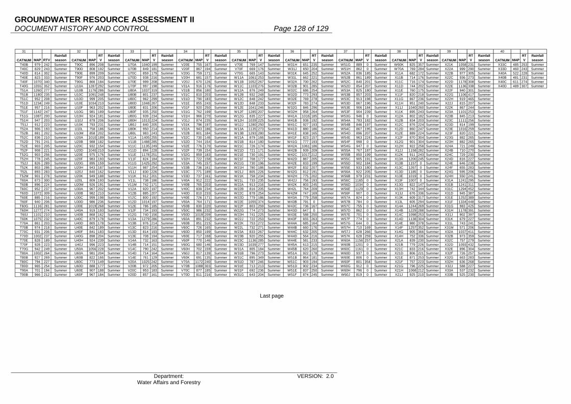
GROUNDWATER RESOURCE ASSESSMENT II DOCUMENT HISTORY AND CONTROL Page 128 of 129
Department: Water Affairs and Forestry
VERSION: 2.0
Last page
31 32 33 34 35 36 37 38 39 40
CATNUM MAP RTVRainfall season CATNUM MAP
RTV
Rainfall season CATNUM MAP
RTV
Rainfall season CATNUM MAP
RTV
Rainfall season CATNUM MAP
RTV
Rainfall season CATNUM MAP
RTV
Rainfall season CATNUM MAP
RTV
Rainfall season CATNUM MAP
RTV
Rainfall season CATNUM MAP
RTV
Rainfall season CATNUM MAP
RTV
Rainfall season
T40B 979 242 Summer T90C 896 208 Summer U70A 1040 199 Summer V20E 755 167 Summer V70E 769 147 Summer W31H 651 235 Summer W51G 889 0 Summer W60K 825 357 Summer X21K 1058 231 Summer X33C 485 253 SummerT40C 829 243 Summer T90D 808 192 Summer U70B 849 181 Summer V20F 867 194 Summer V70F 669 176 Summer W31J 650 204 Summer W51H 862 0 Summer W70A 769 284 Summer X22A 999 290 Summer X33D 460 243 SummerT40D 814 302 Summer T90E 899 209 Summer U70C 859 179 Summer V20G 759 171 Summer V70G 665 143 Summer W31K 645 252 Summer W52A 836 185 Summer X11A 682 172 Summer X22B 977 305 Summer X40A 522 228 SummerT40E 823 333 Summer T90F 976 203 Summer U70D 938 216 Summer V20H 681 157 Summer W11A 1061 253 Summer W31L 662 221 Summer W52B 861 189 Summer X11B 714 176 Summer X22C 936 273 Summer X40B 481 231 SummerT40F 1070 340 Summer T90G 866 184 Summer U70E 999 208 Summer V20J 670 126 Summer W11B 1052 267 Summer W32A 700 262 Summer W52C 840 201 Summer X11C 716 174 Summer X22D 1178 308 Summer X40C 611 274 SummerT40G 1055 352 Summer U10A 1287 292 Summer U70F 997 198 Summer V31A 916 176 Summer W11C 1103 276 Summer W32B 901 285 Summer W52D 854 207 Summer X11D 744 202 Summer X22E 1136 338 Summer X40D 489 307 SummerT51A 1260 277 Summer U10B 1176 286 Summer U80A 1037 319 Summer V31B 856 180 Summer W12A 876 249 Summer W32C 686 254 Summer W53A 825 180 Summer X11E 760 175 Summer X22F 940 301 SummerT51B 1180 235 Summer U10C 1091 248 Summer U80B 801 237 Summer V31C 810 203 Summer W12B 932 248 Summer W32D 773 293 Summer W53B 857 203 Summer X11F 820 218 Summer X22G 1106 417 SummerT51C 952 208 Summer U10D 999 205 Summer U80C 962 299 Summer V31D 790 183 Summer W12C 848 242 Summer W32E 769 278 Summer W53C 913 198 Summer X11G 867 236 Summer X22H 919 465 SummerT51D 1234 249 Summer U10E 1034 210 Summer U80D 1048 267 Summer V31E 855 243 Summer W12D 848 233 Summer W32F 783 274 Summer W53D 867 196 Summer X11H 951 240 Summer X22J 815 207 SummerT51E 957 216 Summer U10F 963 202 Summer U80E 831 206 Summer V31F 920 250 Summer W12E 1041 246 Summer W32G 846 296 Summer W53E 906 184 Summer X11J 1040 260 Summer X22K 867 244 SummerT51F 1142 247 Summer U10G 981 189 Summer U80F 935 250 Summer V31G 762 199 Summer W12F 1285 207 Summer W32H 958 264 Summer W53F 904 239 Summer X11K 895 243 Summer X23A 1101 253 SummerT51G 1087 200 Summer U10H 924 181 Summer U80G 939 234 Summer V31H 966 270 Summer W12G 835 227 Summer W41A 1016 185 Summer W53G 946 0 Summer X12A 802 182 Summer X23B 845 213 SummerT51H 947 203 Summer U10J 878 206 Summer U80H 1013 224 Summer V31J 874 235 Summer W12H 1039 225 Summer W41B 938 192 Summer W54A 783 182 Summer X12B 834 203 Summer X23C 1111 256 SummerT51J 912 223 Summer U10K 793 231 Summer U80J 840 205 Summer V31K 796 197 Summer W12J 1280 250 Summer W41C 927 193 Summer W54B 846 197 Summer X12C 876 224 Summer X23D 814 199 SummerT52A 906 193 Summer U10L 758 186 Summer U80K 950 214 Summer V32A 943 186 Summer W13A 1135 273 Summer W41D 880 186 Summer W54C 867 195 Summer X12D 860 247 Summer X23E 1016 259 SummerT52B 881 202 Summer U10M 858 202 Summer U80L 983 243 Summer V32B 801 184 Summer W13B 1293 280 Summer W41E 838 165 Summer W54D 896 207 Summer X12E 889 224 Summer X23F 820 221 SummerT52C 836 210 Summer U20A 1010 189 Summer V11A 1405 255 Summer V32C 730 146 Summer W21A 879 166 Summer W41F 823 157 Summer W54E 963 224 Summer X12F 870 304 Summer X23G 882 265 SummerT52D 791 241 Summer U20B 988 182 Summer V11B 1488 285 Summer V32D 744 154 Summer W21B 814 180 Summer W41G 777 193 Summer W54F 998 0 Summer X12G 901 304 Summer X23H 882 265 SummerT52E 903 205 Summer U20C 932 154 Summer V11C 1135 249 Summer V32E 776 170 Summer W21C 726 174 Summer W42A 1061 186 Summer W54G 947 0 Summer X12H 922 258 Summer X24A 721 249 SummerT52F 908 221 Summer U20D 1040 210 Summer V11D 894 228 Summer V32F 739 154 Summer W21D 721 171 Summer W42B 939 209 Summer W55A 767 187 Summer X12J 1158 282 Summer X24B 710 270 SummerT52G 903 256 Summer U20E 975 176 Summer V11E 1178 251 Summer V32G 859 183 Summer W21E 730 191 Summer W42C 1017 212 Summer W55B 850 199 Summer X12K 911 243 Summer X24C 729 230 SummerT52H 778 245 Summer U20F 983 193 Summer V11F 824 184 Summer V32H 722 158 Summer W21F 708 177 Summer W42D 887 205 Summer W55C 905 191 Summer X13A 1200 245 Summer X24D 816 227 SummerT52J 826 289 Summer U20G 895 159 Summer V11G 1425 292 Summer V33A 745 157 Summer W21G 730 196 Summer W42E 833 199 Summer W55D 902 184 Summer X13B 1157 0 Summer X24E 646 238 SummerT52K 803 286 Summer U20H 943 187 Summer V11H 987 254 Summer V33B 736 161 Summer W21H 780 186 Summer W42F 832 207 Summer W55E 933 180 Summer X13C 1267 0 Summer X24F 655 283 SummerT52L 893 283 Summer U20J 840 162 Summer V11J 830 226 Summer V33C 771 189 Summer W21J 805 226 Summer W42G 812 191 Summer W56A 922 205 Summer X13D 1185 0 Summer X24G 595 206 SummerT52M 901 278 Summer U20K 949 188 Summer V11K 912 201 Summer V33D 737 161 Summer W21K 758 234 Summer W42H 775 202 Summer W56B 979 231 Summer X13E 1019 0 Summer X24H 550 241 SummerT60A 873 300 Summer U20L 809 193 Summer V11L 738 186 Summer V40A 912 222 Summer W21L 733 235 Summer W42J 756 193 Summer W56C 1165 0 Summer X13F 1007 0 Summer X31A 1241 295 SummerT60B 896 224 Summer U20M 926 191 Summer V11M 742 171 Summer V40B 765 203 Summer W22A 913 216 Summer W42K 803 245 Summer W56D 1034 0 Summer X13G 822 147 Summer X31B 1241 311 SummerT60C 952 237 Summer U30A 967 202 Summer V12A 920 197 Summer V40C 839 234 Summer W22B 816 205 Summer W42L 764 209 Summer W56E 1129 0 Summer X13H 742 344 Summer X31C 1294 452 SummerT60D 1072 309 Summer U30B 982 210 Summer V12B 885 207 Summer V40D 810 233 Summer W22C 878 254 Summer W42M 747 169 Summer W56F 907 0 Summer X13J 676 336 Summer X31D 945 387 SummerT60E 885 216 Summer U30C 999 198 Summer V12C 800 192 Summer V40E 726 171 Summer W22D 779 186 Summer W43A 779 258 Summer W57A 824 0 Summer X13K 609 317 Summer X31E 1252 389 SummerT60F 940 206 Summer U30D 986 236 Summer V12D 1014 197 Summer V50A 764 171 Summer W22E 1055 374 Summer W43B 791 0 Summer W57B 784 0 Summer X13L 605 294 Summer X31F 1334 448 SummerT60G 1116 281 Summer U30E 1019 268 Summer V12E 786 185 Summer V50B 830 220 Summer W22F 803 259 Summer W43C 736 167 Summer W57C 755 0 Summer X14A 1244 269 Summer X31G 983 425 SummerT60H 1277 274 Summer U40A 919 193 Summer V12F 734 193 Summer V50C 986 232 Summer W22G 774 273 Summer W43D 647 0 Summer W57D 862 0 Summer X14B 1229 288 Summer X31H 1178 391 SummerT60J 1101 210 Summer U40B 868 162 Summer V12G 740 156 Summer V50D 1019 209 Summer W22H 741 225 Summer W43E 588 250 Summer W57E 701 0 Summer X14C 1098 253 Summer X31J 902 397 SummerT60K 1075 232 Summer U40C 879 178 Summer V13A 1279 286 Summer V60A 891 232 Summer W22J 722 253 Summer W43F 655 263 Summer W57F 774 0 Summer X14D 1138 304 Summer X31K 679 227 SummerT70A 861 203 Summer U40D 865 178 Summer V13B 976 214 Summer V60B 851 215 Summer W22K 753 272 Summer W44A 685 164 Summer W57G 644 0 Summer X14E 980 378 Summer X31L 743 241 SummerT70B 974 218 Summer U40E 842 189 Summer V13C 823 216 Summer V60C 726 165 Summer W22L 732 271 Summer W44B 660 176 Summer W57H 710 169 Summer X14F 1257 352 Summer X31M 571 206 SummerT70C 931 206 Summer U40F 841 183 Summer V13D 814 193 Summer V60D 850 199 Summer W23A 833 267 Summer W44C 632 205 Summer W57J 628 266 Summer X14G 905 366 Summer X32A 1037 411 SummerT70D 1002 237 Summer U40G 898 204 Summer V13E 708 194 Summer V60E 717 168 Summer W23B 920 255 Summer W44D 564 216 Summer W57K 628 259 Summer X14H 752 336 Summer X32B 973 359 SummerT70E 828 189 Summer U40H 924 239 Summer V14A 732 163 Summer V60F 770 146 Summer W23C 1136 285 Summer W44E 581 233 Summer W60A 1156 257 Summer X21A 839 230 Summer X32C 757 279 SummerT70F 928 223 Summer U40J 996 223 Summer V14B 714 151 Summer V60G 680 146 Summer W23D 1039 277 Summer W45A 613 215 Summer W60B 1201 0 Summer X21B 779 226 Summer X32D 1093 432 SummerT70G 942 249 Summer U50A 1056 228 Summer V14C 790 242 Summer V60H 702 159 Summer W31A 805 184 Summer W45B 620 260 Summer W60C 1161 0 Summer X21C 833 216 Summer X32E 896 304 SummerT80A 1002 264 Summer U60A 981 204 Summer V14D 714 164 Summer V60J 817 139 Summer W31B 796 273 Summer W51A 922 178 Summer W60D 937 0 Summer X21D 806 221 Summer X32F 726 257 SummerT80B 927 269 Summer U60B 822 166 Summer V14E 761 129 Summer V60K 691 135 Summer W31C 895 349 Summer W51B 864 181 Summer W60E 806 0 Summer X21E 871 253 Summer X32G 663 283 SummerT80C 794 227 Summer U60C 773 149 Summer V20A 1025 242 Summer V70A 1172 240 Summer W31D 787 246 Summer W51C 903 194 Summer W60F 801 354 Summer X21F 757 223 Summer X32H 636 268 SummerT80D 965 254 Summer U60D 888 177 Summer V20B 972 205 Summer V70B 1088 303 Summer W31E 713 213 Summer W51D 902 234 Summer W60G 912 0 Summer X21G 796 225 Summer X32J 588 227 SummerT90A 701 194 Summer U60E 907 188 Summer V20C 953 183 Summer V70C 877 185 Summer W31F 692 236 Summer W51E 837 250 Summer W60H 796 0 Summer X21H 1068 212 Summer X33A 537 232 SummerT90B 966 212 Summer U60F 967 184 Summer V20D 857 161 Summer V70D 811 216 Summer W31G 643 204 Summer W51F 874 245 Summer W60J 819 0 Summer X21J 925 210 Summer X33B 525 230 Summer

GROUNDWATER RESOURCE ASSESSMENT II DOCUMENT HISTORY AND CONTROL Page 129 of 129
Department: Water Affairs and Forestry
VERSION: 2.0
DOCUMENT HISTORY
NUMBER OF LAST CHANGE REQUEST INCLUDED
COMMENTS
PAGE NUMBERS OF
PAGES CHANGED
FOR AMENDMENTS
VERSION DATE PRODUCER
2.0 2006-06-20 J Conrad, P Rosewarne
Endorsed by professional / scientific team Name Signature Date P Rosewarne 2006-06-20
DOCUMENT ACCEPTANCE Role Name Signature Date Producer3 SGWC Consortium 2006-06-20 Accepted by4 E van Wyk Project Coordinator J Girman Project Sponsor H Pienaar
3 Winner of tender: Company executive 4 DWAF professionals approving the document