Embed Size (px)
Citation preview

GROUP 45
OBJECTION NO 197 REBUTTAL TO WITNESS STATEMENT FROM PATRICIA ALDERSON BADGERS PROMOTER REBUTTAL BY ANDREW COATES 1 Background 1.1 This rebuttal statement is presented in response to the witness statement of
Patricia Alderson representing Group 45 (FRUWCA) regarding badgers in the Roseburn Corridor.
2 Issues of Concern
Badgers 2.1 In paragraph 3 of Mrs Alderson’s Witness Statement, she expresses some
concerns over the construction of badger tunnels in the Roseburn Corridor, particularly in relation to drainage. It is correct that as part of the Badger Mitigation Plan (BMP) measures such as tunnels and fencing are proposed to prevent badgers from crossing the tram line (as described in my Witness Statement to this Group). Where tunnels are agreed as the best form of mitigation, these will be designed in consultation with Scottish Natural Heritage (SNH) and the Edinburgh and Lothians Badger Group (ELBG) to the required specification and will be located as close as possible to existing badger pathways. The design of such mitigation measures will be developed alongside the detail design of the scheme and will allow for factors such as topography and drainage to ensure their effectiveness and longevity.
2.2 Mrs Alderson raises concerns in paragraphs 4-7 of her statement about the
effects of the ETL1 proposals on the foraging habitat of badgers and that the proposals will deliberately increase badgers’ dependence on gardens for food. As described in my Witness Statement for this Group, the proposals for the Roseburn Corridor will have minimal effect on the foraging territory of the social groups along the corridor, much of which appears to lie outwith the confines of the corridor; as recognised by Mrs Alderson, there are badger paths both within and to and from the corridor. There is no deliberate intention to encourage badgers to forage more in gardens; the Landscape and Habitat Management Plan (LHMP) describes the proposals to enhance the habitats that will remain in the Corridor and to provide new foraging resources for badgers.

2.3 In paragraph 7, Mrs Alderson raises a concern about how badgers will maintain longitudinal access along the corridor particularly in locations where the width of the corridor is somewhat restricted. All existing badger pathways, both along and across the corridor will be considered in design of the mitigation as part of the BMP and appropriate measures put in place to maintain access through existing social group territories along the Corridor.
2.4 Mrs Alderson raises concerns in paragraph 8 about the possibility of an
increase in road kills if badgers are forced on to roads during construction. I recognise that this can be a risk if not properly addressed. As described in my Witness Statement, as part of the BMP mitigation measures will be put in place for both the construction and operation of the tram to minimise the risk of this occurring. Mrs Alderson describes the effects that a large housing development near Corstorphine Hill had on badger foraging resource and that this lead to an increase in road kills in the area. The ETL1 proposals differ from those of the development described at Corstorphine Hill, especially as the ETL1 proposals will not result in the loss of large areas of grazing pasture, a habitat type which is known to be favoured by foraging badgers. Mitigation measures will be designed in consultation with SNH and ELBG as part of the BMP to address these types of concerns.
2.5 In paragraph 9 Mrs Alderson raises the concern of badgers becoming
trapped on the tram line and being hit by the tram. The Promoter is committed to producing a BMP which will detail the proposals for mitigation for badgers both during construction and operation, including measures to avoid badgers becoming trapped within the tramway. SNH has confirmed that they are content with the approach to mitigating the effects on badgers along the Roseburn Corridor.
2.6 Finally, Mrs Alderson suggests that a single rather than double tram track
will improve the tram line for badgers. If construction of a single track option is adopted about a third less vegetation (or foraging area) will be lost compared with the twin track option. However, the ETL1 proposals will only have a small effect on the overall foraging territory of the badger social groups using the corridor anyway. Hence the benefit in terms of retaining foraging area will be very small in comparison to the total foraging areas used by the Roseburn badgers and in comparison to the advantages of double tracking outlined in a previous response to the Committee. The benefit from the partial single track option would be even less.
Andrew Coates Principal Consultant, ERM 12 August 2005

GROUP 45
FRIENDS OF THE ROSEBURN URBAN WILDLIFE CORRIDOR
REBUTTAL TO WITNESS STATEMENT FROM KRISTINA WOOLNOUGH ON INADEQUACY OF FLORA AND FAUNA SURVEYS AND MITIGATION PROPOSALS PROMOTER REBUTTAL BY ANDREW COATES 1 Background This rebuttal statement is presented in response to the witness statement of Kristina Woolnough representing Group 45 (The Friends of the Roseburn Wildlife Corridor Association) regarding inadequacy of flora and fauna surveys and mitigation proposals. In her statement for this group Ms Woolnough adopts her statements made on behalf of Group 34 on the subjects of badgers, birds, bats, vegetation and insects and the amendments and proposals made in them. I am in the same way adopting my rebuttals to Group 34 on all these issues. I refer also to colleagues’ rebuttals of Ms Woolnough’s evidence for Group 34 in respect of her concerns regarding inappropriate bias and lack of evidence. 2 Adequacy of Surveys for Flora and Fauna 2.1 As Ms Woolnough refers to her statement on behalf of Group 34 my
response to this can also be found in my rebuttal of that statement. 2.2 In her statement for this group Ms Woolnough also makes a supplementary
request for the Promoter to survey fully for other mammals (including roe deer and fox) and to survey for amphibians and fish.
2.3 In my rebuttal to Group 34 I explained the survey criteria for the different
species groups, as outlined in 'Guidelines for Baseline Ecological Assessment' Institute for Environmental Assessment, Spon (1995). The only ‘protected’ mammal species known from the corridor are badgers and bats and the surveys for these are described elsewhere. It is recognised that there have been recorded signs of roe deer, fox, grey squirrel and rabbit in the corridor and there will also be small mammals, such as mice, shrews and voles. All wild mammals (including red fox and roe deer) afford limited protection under the Wild Mammals (Protection) Act 1996 and amendments which make it an offence to inflict unnecessary suffering on any wild animal. Roe deer also afford limited protection under the Deer (Scotland) Act 1996 and amendments which prohibits 'poaching', the use of snares and shooting of deer at night and dictates the seasons during which deer can be killed and the type of weapons that can be used. Other than this very limited protection there is no legislation that protects these species from disturbance and therefore there is no licence requirement for works that may affect them. Species such as fox, grey squirrel and rabbit are all common and widespread species and it is not a statutory requirement to survey for these species as part of the Environmental Impact Assessment (EIA)

process. It is not considered necessary for detailed surveys of these species to be undertaken.
2.4 During the desk study and survey work undertaken for the EIA, there were
no records or signs of amphibian or fish species and no apparent suitable habitat. It is acknowledged that there have been sightings by local residents where temporary ponds have occurred in the past, but this habitat was not present during any of the survey work undertaken for this project. As discussed above, surveys need only be conducted where there are records of or suitable habitat for protected amphibians such a great crested newt, or protected fish species, which is not the case here. It is not therefore deemed necessary to conduct these surveys.
3 Adequacy of Mitigation
3.1 The habitat creation proposals outlined in the LHMP have been designed to
provide benefits to a variety of wildlife that use the Corridor and are considered to provide the best practicable mitigation for impacts on the corridor. The principles and proposals set out in the LHMP have been subject to consultation and agreement with SNH and the City of Edinburgh Council’s Natural Heritage Team, and will continue to be developed and implemented in consultation with them.
4 Inappropriate Bias and Lack of Evidence
4.1 On this issues (inappropriate bias and lack of evidence in presenting Roseburn Corridor information and devaluing of the Corridor) I refer to my own and my colleague Karen Raymond’s rebuttals to Ms Woolnough’s statement on behalf of Group 34.
Andrew Coates Principal Consultant, ERM 12 August 2005

GROUP 45
REBUTTAL TO PETER ALLAN’S WITNESS STATEMENT PROMOTER REBUTTAL AILEEN GRANT 1 Background 1.1 I refer to the witness statement of Peter Allan, particularly those
references regarding the local plan. 2 Agreed Issues 2.1 It is agreed with the Objector that there is no such document as the
“Edinburgh Local Plan”. It is also agreed that that the local plan does not “authorise” Tramline 1.
3 Issues in Dispute 3.1 The Objector refers to two local plans – the Central Edinburgh Local
Plan and the North West Edinburgh Local Plan. While these plans do not “authorise” the development of a tramline along the Roseburn Corridor, they safeguard and protect the corridor for the possible construction of a road or the development of a public transport/light rapid transit facility. The North West Edinburgh Local Plan refers to the corridors being held in reserve; the Central Edinburgh Local Plan refers to the corridors being protected for the possible construction of such a facility.
3.2 These designations have within them a flexibility as explained above.
It is accepted that the policies refer to possible road construction as well as development of public transport facility. Whatever the justification was at the time, the local plan policies still stand as contained in those plans.
12th August 2005

GROUP 45
FRIENDS OF THE ROSEBURN URBAN WILDLIFE CORRIDOR
REBUTTAL TO MS WOOLNOUGH’S WITNESS STATEMENT
PROMOTER REBUTTAL AILEEN GRANT 1 Background 1.1 I refer to the witness statement of Ms Woolnough, particularly those
references in relation to Roseburn Corridor as a “linear park”, its biodiversity and maintenance, and the role of the Council as Planning Authority with regard to these matters.
2 Agreed Issues 2.1 It is agreed that the Roseburn corridor is identified as an urban wildlife
site in the Central Edinburgh Local Plan.
3 Issues in Dispute 3.1 The Objector has suggested that the Roseburn Corridor is a “linear
park”. This is not accepted. It is not designated as open space in any local plan.
3.2 The Objector has suggested that there is a policy conflict and that the
local plan policy states that the corridor should be “retained for possible transportation purposes”. This is rebutted. The policy for this corridor actually states that the corridor is safeguarded for possible transportation purposes in the following terms in Policy T4 “The routes indicated on the Proposals Map will be protected for the possible construction of a light rapid transit (LRT) system”. At the same time they were designated as a wildlife site in recognition of their existing characteristics. The policies allow for both, provided mitigation measures are included in transportation proposals. The tram proposals do make provision for mitigation measures.
3.3 The Objector suggests that two different symbols are used and this
implies that the Roseburn corridor was identified as a cycle and walkway. The reason for the different symbols was to reflect that the proposals in respect of Leith Walk and Princes Street were more advanced and identified as “routes of proposed light rapid transit system”, whereas proposals affecting Roseburn Corridor were more tentative and hence identified as a “route to be safeguarded for possible transportation purposes”. This is the wording on the Proposals Map.

3.4 The Objector suggests that there is no evidence that the Council’s
Natural Heritage section was given the opportunity to have input to the principle of using the corridor for Tram Line 1. The Natural Heritage section is one part of the Strategy section within the Planning and Strategy “Service” within the City Development Department. Consultations which take place are purely internal. The views of this section are therefore incorporated within the various Planning Committee reports as the formal input from Planning and Strategy.
3.5 The Objector suggests that she sought evidence of consultation
between the “two sections” and concludes that “normal inter-departmental consultative responses were waived”. As explained, Natural Heritage is not a separate department, and so there was no inter-departmental consultation. Records or evidence of internal discussions – effectively team working between colleagues - are not retained on a formal basis and not therefore available to members of the public. Formal views were not sought from the Transport “Service” as it was understood that tie’s proposals were in accordance with instructions emanating from them. If the Objector has concerns about the Council’s response under Freedom of Information provisions there is a separate complaints procedure for this. No such complaint has been received.
3.6 The Objector suggests that where “the City of Edinburgh Council’s own
development is concerned, normal inter-departmental consultative responses were waived”. This suggests a misunderstanding of the role of the Planning Authority in this instance. The extent of the overall planning consideration of the proposals presented by tie was contained in the various reports to Planning Committee. Planning Committee could not assess the proposals as it is for Parliament to undertake that assessment. However, in promoting the Edinburgh Tram Project, the Council sought a view from the Planning Committee as a means of trying to ensure best practice, integration of planning and transport, and to promote a higher quality of design in the project. The three Planning Committee reports of 2003 have put this consideration in the public domain.
3.7 The role of the Planning Authority as “protector” of biodiversity and
wildlife is now outlined in the recent Nature Conservation (Scotland) Act 2004 which states that we have a duty to further the conservation of biodiversity so far as is consistent with the proper exercise of our functions. The Planning Authority fulfills this duty through the production of the Edinburgh Biodiveristy Action Plan (and partnership working), the designation of locally important habitats (UWS/SINC), local plan policies to protect nationally and locally important habitats, policies to promote the proper management for nature conservation, policies to reduce the impact of development on the nature conservation value of development sites and the implementation of

these policies and the Biodiversity DQ Guideline. This role does not extend to a specific policing role to protect on the ground biodiversity and wildlife within the city - other than with the procedures relating to Tree Preservation Orders and protection of trees in Conservation Areas.
3.8 With regard to the management and maintenance of the Roseburn
Corridor, this is not a matter under the control of the Planning Authority. Maintenance is carried out by the Council’s Department of Environmental and Consumer Services. I have found out that there is a budget of £25K for all the cycleways in the city. There is regular litter picking and broken glass clean-up. There is support given to local litter clean up events. There is also a once a year cut-back of vegetation for 1m either side of the cycleway. This form of low-key maintenance is considered by that Department to meet with the Biodiversity requirements. With regard to the Objector’s criticisms, it is accepted that this management regime may not be perfect, but the Council has restricted resources for this work.
3.9 The Objector has suggested that the Biodiversity Action Plan (EBAP)
has been “watered down”. This is rebutted. The old EBAP had a habitat action plan (HAP) for Wildlife Corridors and a seperate HAP for Urban Habitats. In the new plan, Urban Habitats and Wildlife Corridors have been consolidated into one HAP, the Urban HAP. The old EBAP had no proposed actions for the Roseburn Corridor but the new plan does. This action is to 'minimise disturbance to bank vegitation and wildlife during the construction of tram line 1 via input into the planning process’. This change indicates that the Planning and Strategy “Service” is taking a holistic approach to the corridor and that the EBAP reflects the change of status of the Tram from a safeguarded route to a definite proposal. The local plan established the principle of the corridor being developed for the tram. The new EBAP has simply responded to the fact that the tram is now a live project and accordingly promotes proper mitigation. It is not the role of EBAP to establish land use policy.
3.10 It is worth noting that the revision of the EBAP was done through
partnership working. Stakeholder workshops were held with members of the Edinburgh Biodiversity Partnership. A workshop was held in Summer 2002 and November 2004. However, it is understood that no representation was made by Ms Woolnough or the Friends of the Roseburn Urban Wildlife Corridor in this process.
3.11 With regard to the Objector’s suggestion that there is a conflict of
interest in relation to the “dual role”, the Council frequently acts as developer and there are special provisions under the Planning Acts about how such proposals should be handled – through a Notice of Intention to Develop. In such cases the Planning Committee of the Council is empowered to grant (or refuse) the Council consent, subject to certain checks and balances. In this case, however, Parliament is
essentially being asked to grant or refuse consent and the role of the Council as Planning Authority will only formally come into play for “Prior Approvals”, listed building consent and any other planning applications required at a later stage (after Royal Assent has been given to the Bill). However, in promoting the Edinburgh Tram Project, the Council sought a view from the Planning Committee as explained above. Given the transparency of this approach, there is no conflict of interest.
3.12 It should also be borne in mind that the Planning Authority has a duty in
making planning decisions on applications and particular projects to make these decisions in the public interest through the evaluation of all material considerations. In the case of tram line 1, biodiversity is one factor that is material to this application along with transport, social inclusion etc. It is considered that there is no conflict of interest, as the Roseburn Corridor has been identified in the local plan as a safeguarded transport route and an UWS. The principle of the Roseburn Corridor having a dual function has been established in the statutory development plan and our duty to further the conservation of biodiversity has been fulfilled by commenting on the preparation of mitigation i.e. Landscape and Habitat Management Plan.
4. Conclusions 4.1 In the Central Edinburgh Local Plan, the Roseburn corridor has policy
designations both as an urban wildlife corridor (reflecting its existing characteristics) and as a Transportation safeguard for possible future LRT. It is not considered that there is a conflict between these designations, provided the Tram proposals incorporate appropriate wildlife mitigation measures. The corridor is not designated as an open space.
4.2 The Council’s Planning Committee has given a view to the Council on
various matters. These views did not amount to a full planning consideration of the emerging tram proposals. Such a consideration would not have been appropriate given that it is for Parliament to make a full assessment in considering the Private Bill.
4.3 The Planning and Strategy Service of City Development Department
have acted responsibly and transparently in discharging our duties with regard to biodiversity and the interpretation of local plan policies. The Natural Heritage section are part of the Strategy section of Planning and Strategy and their comments were incorporated into the overall planning response.
12 August 2005
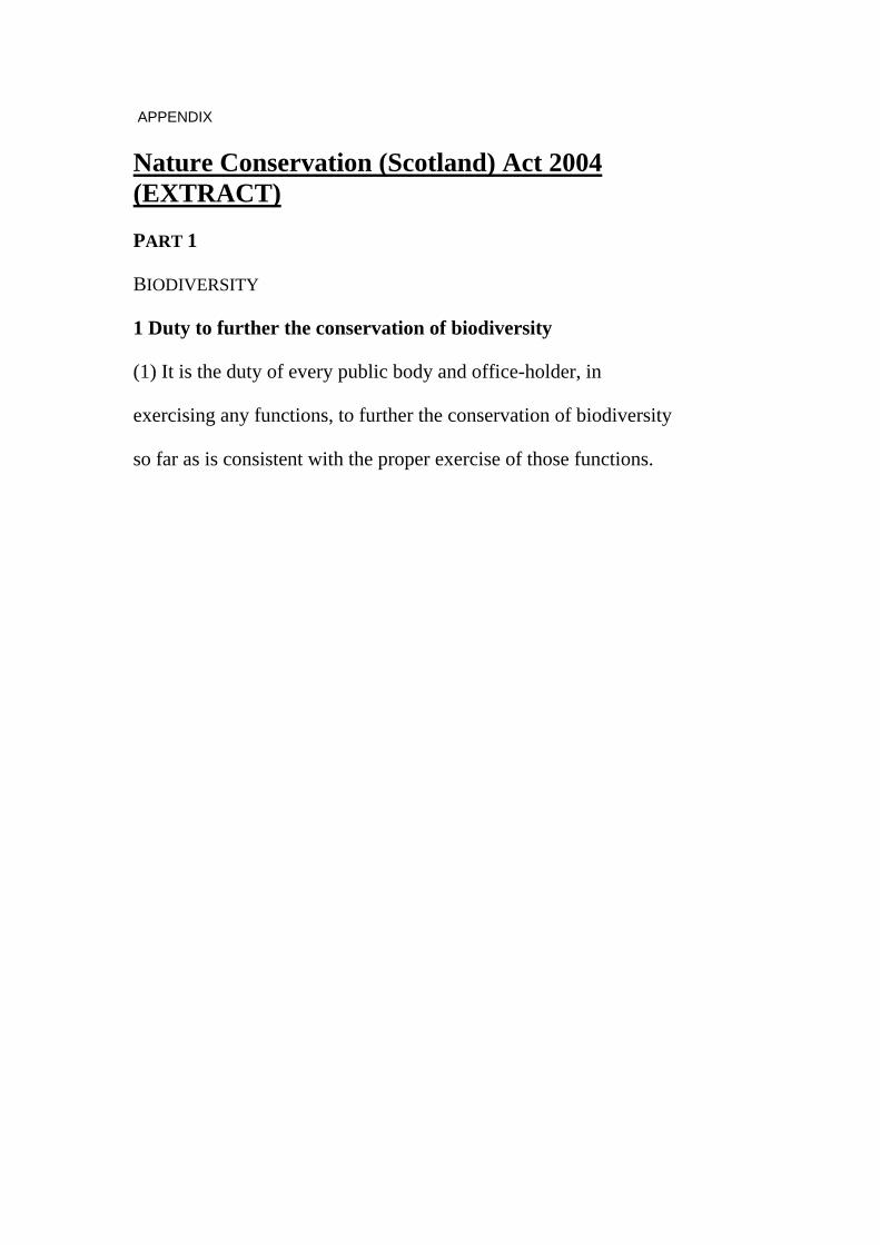
APPENDIX Nature Conservation (Scotland) Act 2004 (EXTRACT)
PART 1
BIODIVERSITY
1 Duty to further the conservation of biodiversity
(1) It is the duty of every public body and office-holder, in
exercising any functions, to further the conservation of biodiversity
so far as is consistent with the proper exercise of those functions.

GROUP 45
FRIENDS OF THE ROSEBURN URBAN WILDLIFE CORRIDOR
REBUTTAL TO PETER P C ALLAN WITNESS STATEMENT
PROMOTER REBUTTAL BY
Dick Dapré
1. BACKGROUND
1.1. This Rebuttal statement is presented in response to the Witness Statement of Peter Allan, representing Group 45 (Friends of the Roseburn Urban Wildlife Corridor). Mr Allan’s statement deals with the planning framework.
1.2. My rebuttal addresses only the tram speed and safety issues raised by Mr Allan over which there is no agreement between Promoter and Objector. I have described these in my Witness Statement for this Group. Other issues of contention will be addressed by my colleagues.
2. AGREED ISSUES
2.1. It is agreed that the Roseburn Railway Corridor serves an important function as a transport link for non-motorised modes, i.e. walking and cycling, and thus a recreational facility.
2.2. The proposed scheme will stop up the existing footway/cycleway, which is a road under the Roads (Scotland) Act 1984, and construct the tramway with a new footway/cycleway alongside. The tramway will not be a road under the Act, but the new footway/cycleway will be.
3. DISPUTED ISSUES
3.1. Disputed issues centre on the impacts that the tram scheme will have on the footway/cycleway, its users and local residents. Clearly there will be some impacts, but the Promoter is of the view that these will be limited to the extent that the new facility will enable and encourage people to continue to use the footway/cycleway as a safe transport and recreational resource.
3.2. The current condition of the footway/cycleway appears less than ideal in terms of cleanliness, safety and personal security, because of dog excrement, litter, nettles, poor light caused by overhanging trees etc. Whatever the reason for this, the impact of a tram is likely to be lessened as a result.

3.3. The areas I am addressing are the safety of the tramway, the speed of tram operation and general issues of interaction with users of the footway/cycleway. In the sections below I deal with specific issues in these areas that have been raised by the Objector and are disputed by the Promoter.
3.4. Issue: “In order to deal with loss of amenity and adverse effect on wildlife, the tram should be required to travel at no greater speed than on a true multi-modal corridor, viz, 20mph or 30mph maximum” (Objector’s Witness Statement, paragraph 5.1).
3.5. As I explained in my Witness Statement, there is no necessity to apply such a low speed limit. Access and freedom of movement will be preserved, both parallel to the tram tracks along the footway/cycleway and across them at designated crossing points provided wherever necessary.
3.6. The use of the term “a true multi-modal corridor” is potentially misleading as it could be taken to mean that trams and other users will share space. In reality there will be two parallel facilities.
3.7. It must be recognised by all concerned that a road carrying only 16 movements an hour would be considered a quiet country lane; by the same token a tramway – which is not a public right of way – carrying only 16 trams per hour can be considered a very quiet facility.
3.8. Tramways are driven ‘on line of sight’ which means that the driver always drives at a speed that means that he/she can stop the car safely if they see an obstruction ahead. Drivers are specially trained to have excellent ‘route knowledge’ and to adopt risk avoidance strategies. This is a great contrast to public roads where many drivers may be using the road for the first time and are not aware of the particular characteristics of the route.
3.9. On a tramway such as that proposed in the Roseburn Railway Corridor there is no need to cross the tramway except where access points are on the opposite side from the footway/cycleway, or to reach stop platforms. Drivers will be well aware of these crossing points and will be trained to adopt a style of driving that minimises risks at these locations. Furthermore, since many of these crossing points are adjacent to stops, tram speeds will already be reduced.
3.10. Generally speaking these designated crossing points will be as open as possible to allow clear views for both pedestrians and tram drivers. Sections of fence may be introduced to prevent thoughtless pedestrians from rushing out from an access point onto the tramway and, where necessary, to turn pedestrians to face oncoming trams. Each situation will be individually analysed and detailed design will only follow discussion with HM Railway Inspectorate.

3.11. Pedestrians will be aware of the change from the footway to the tramway by the change of texture from paved footway to grass track. This change point will be indicated by an edge stone that will form an indication to the visually handicapped, or by means of a low kick rail as used with success on Croydon Tramlink, which further emphasises this change in a way that is not unduly intrusive. Sections of fence may be introduced in areas where clearances are restricted. In all such locations, the layout is specifically designed for safety and subject to HMRI approval.

GROUP 45
FRIENDS OF THE ROSEBURN URBAN WILDLIFE CORRIDOR REBUTTAL TO KRISTINA WOOLNOUGH WITNESS STATEMENT PROMOTER REBUTTAL BY DICK DAPRÉ
1. BACKGROUND
1.1. This Rebuttal statement is presented in response to the Witness Statement of Kristina Woolnough, representing Group 45 (Friends of the Roseburn Urban Wildlife Corridor). Ms Woolnough’s statement summarises the objections of Group 45.
1.2. My rebuttal addresses only the tram speed and safety issues raised by Ms Woolnough over which there is no agreement between Promoter and Objector. I have described these in my Witness Statement for this Group. Other issues of contention will be addressed by my colleagues.
2. AGREED ISSUES
2.1. It is agreed that the Roseburn Railway Corridor serves an important function as a transport link for non-motorised modes, i.e. walking and cycling, and thus a recreational facility.
2.2. The proposed scheme will stop up the existing footway/cycleway, which is a road under the Roads (Scotland) Act 1984, and construct the tramway with a new footway/cycleway alongside. The tramway will not be a road under the Act, but the new footway/cycleway will be.
3. DISPUTED ISSUES
3.1. Disputed issues centre on the impacts that the tram scheme will have on the footway/cycleway, its users and local residents. Clearly there will be some impacts, but the Promoter is of the view that these will be limited to the extent that the new facility will enable and encourage people to continue to use the footway/cycleway as a safe transport and recreational resource.
3.2. The current condition of the footway/cycleway appears less than ideal in terms of cleanliness, safety and personal security, because of dog excrement, litter, nettles, poor light caused by overhanging trees etc. Whatever the reason for this, the impact of a tram is likely to be lessened as a result.
3.3. The areas I am addressing are the safety of the tramway, the speed of tram operation and general issues of interaction with users of the footway/cycleway. In

the sections below I deal with specific issues in these areas that have been raised by the Objector and are disputed by the Promoter.
3.4. Issue: “The particular character of the Roseburn Corridor – that it is intensely used – needs to be taken into account by the Promoter” (Objector’s Witness Statement).
3.5. It is the Promoter’s contention that the proposal for a realigned footway/cycleway alongside the tramway is entirely appropriate for the level of use. My colleague Gary Turner will present evidence on the design of the footway/cycleway including its width in relation to the level of use and the appropriate design guidance.
3.6. Issue: “…unclear status of tramway/walkway/cycleway – who controls speed and other safety features, including for disabled/visually-impaired, vulnerable Corridor users? …whether HMRI will require segregation or whether speed restrictions would serve a more appropriate safety function if the open aspect of the Corridor is to be retained” (Objector’s Witness Statement)
3.7. All aspects of the design of the tramway are subject to the approval of the HM Railway Inspectorate, at the design stage, during construction and before opening. The system cannot operate until all elements of the design and operating practices have been approved. Speeds and other safety features are part of this process; it is for the Promoter to put forward proposals and for the HMRI to approve them or require modifications.
3.8. I understand that the Inspector of Railways involved in these discussions has stated that there is no reason to consider any speed other than 80 km/h for the Roseburn corridor, except at any specific locations where constraints such as visibility or structures would dictate a lower local restriction.
3.9. The details of the track form, surfacing, barriers and crossings are still being developed, and discussions will continue to be held with HMRI. Details will be subject to the full approvals process.
3.10. Issue: “Amendment to Bill to introduce maximum speeds of 20mph on the Roseburn Corridor and to include highest safety specifications for pedestrians/Corridor users but retaining multi-modal Corridor, with open aspect” (Objector’s Witness Statement).
3.11. As I have explained above and in my Witness Statement, there is no necessity to apply such a low speed limit. Access and freedom of movement will be preserved, both parallel to the tram tracks along the footway/cycleway and across them at designated crossing points provided wherever necessary.
3.12. My colleague Jim Harries will comment on the operator implications of such a speed restriction.

3.13. The use of the term “multi-modal corridor” is potentially misleading as it could be taken to mean that trams and other users will share space. In reality there will be two parallel facilities.
3.14. It must be recognised by all concerned that a road carrying only 16 movements an hour would be considered a quiet country lane; by the same token a tramway – which is not a public right of way – carrying only 16 trams per hour can be considered a very quiet facility.
3.15. Tramways are driven ‘on line of sight’ which means that the driver always drives at a speed that means that he/she can stop the car safely if they see an obstruction ahead. Drivers are specially trained to have excellent ‘route knowledge’ and to adopt risk avoidance strategies. This is a great contrast to public roads where many drivers may be using the road for the first time and are not aware of the particular characteristics of the route.
3.16. On a tramway such as that proposed in the Roseburn Railway Corridor there is no need to cross the tramway except where access points are on the opposite side from the footway/cycleway, or to reach stop platforms. Drivers will be well aware of these crossing points and will be trained to adopt a style of driving that minimises risks at these locations. Furthermore, since many of these crossing points are adjacent to stops, tram speeds will already be reduced.
3.17. Generally speaking these designated crossing points will be as open as possible to allow clear views for both pedestrians and tram drivers. Sections of fence may be introduced to prevent thoughtless pedestrians from rushing out from an access point onto the tramway and, where necessary, to turn pedestrians to face oncoming trams. Each situation will be individually analysed and detailed design will only follow discussion with HM Railway Inspector.
3.18. Pedestrians will be aware of the change from the footway to the tramway by the change of texture from paved footway to grass track. This change point will be indicated by an edge stone that will form an indication to the visually handicapped, or by means of a low kick rail as used with success on Croydon Tramlink, which further emphasises this change in a way that is not unduly intrusive. Sections of fence may be introduced in areas where clearances are restricted. In all such locations, the layout is specifically designed for safety and subject to HMRI approval.
3.19. Safety specifications are ensured by the HMRI approvals process and there is no necessity to amend the Bill to include them.

OBJECTOR GROUP 45 REBUTTAL TO PATRICIA ALDERSON WITNESS STATEMENT PROMOTER REBUTTAL BY GARY TURNER
1 Background 1.1 This rebuttal is prepared in response to the witness statement
submitted by Patricia Alderson of Group 45. Generally speaking the subject of this objector's statement is covered in my witness statement.
1.2 It will cover the points raised associated with: Drainage 2 Agreed Issues 2.1 Drainage
The introduction of a tram system onto the Roseburn Corridor will include a positive drainage system which will collect and dispose of all surface water associated with the tram system. This will include drainage provision for all associated engineering works such as badger tunnels.
3 Issues in Dispute 3.1 There are no issues in dispute with regard to drainage of badger
tunnels. 4 Conclusion 4.1 The introduction of a tram system onto the Roseburn Corridor will
include a positive drainage system which will collect and dispose of all surface water associated with the tram system. This will include drainage provision for all associated engineering works such as badger tunnels.
Gary Turner Divisional Director Mott MacDonald 12 August 2005

OBJECTOR GROUP 45
REBUTTAL TO KRISTINA WOOLNOUGH WITNESS STATEMENT PROMOTER REBUTTAL BY GARY TURNER 1 Background 1.1 This rebuttal is prepared in response to the witness statement
submitted by Kristina Woolnough of Group 45. Generally speaking the subject of this objector's statement is covered in my witness statement.
1.2 It will cover the points raised associated with: Corridor Access Cycleway/walkway width Existing bridge structures 2 Agreed Issues 2.1 Existing bridge structures.
It is agreed with the objector that existing structures should be retained where ever possible. The current proposals are to retain the existing structures and to retain them in their existing form as far as is practical. Where the headroom is less than required at overline bridges (bridges that the tram travels under) the bridges will again be retained where possible and the solum lowered to give the clearances required. Underpinning of such bridges will be undertaken if required, and as far as is practical, to avoid replacement.
3 Issues in Dispute 3.1 Corridor Access
The objector expresses concern that the corridor has poor access for the Ravelston and Craigleith tram stops. The promoter will be retaining all existing formal access points and where these are at tram stops they will be improved to make them DDA compliant. The stop at Ravelston Dykes in particular will be improved by the introduction of an access ramp which would be in addition to the existing access provision which links Ravelston Dykes with Craigleith View. An additional link to the corridor is proposed from the footpath linking Craigleith View with Craigleith Drive. The current proposals at Ravelston Dykes raise the level of the tram alignment by some 2m to mitigate the need for lift access as well as ramp access. This has been reflected in the LHMP proposals for this area.

3.2 The access to the stop at Craigleith will utilise the formal access points from South Groathill Avenue, Maidencraig Cresent and Maidencraig Grove. These access points are generally at grade and will be improved to ensure that they are DDA compliant. The formal access at points at Queensferry Road and South Groathill Avenue (adjacent to Goathill Road South) will also be retained although some realignment is likely to accommodate the tram works and ensure good pedestrian sight lines.
3.3 In general, the proposed DDA compliant access points to stops along the Roseburn Corridor, and the introduction of additional formal access points, will give improved access for a much wider group of users of the corridor itself than the existing provision.
3.4 My colleague Scott McIntosh will give evidence on access during construction should this be required. With regard to crossing points my colleague Dick Dapre will give further details on this but in principle all crossing points will be formalised and will be provided at all tram stop locations. Where access points to the corridor are remote from tram stop locations and are on the opposite side to the walkway/cycleway then further formal crossing points will be provided.
3.5 The concern over the “invisibility” of tram stops has been expressed particularly when tram routes are on former railway corridors. This is an issue that the promoter is well aware of. This will be addressed through suitable signage that will give visibility to tram stops locations and their access routes to those users not familiar with the area.
3.6 Cycleway/walkway width
The number of user movements recorded by Blackhall Community Association and FRUWCA during May 2005 indicated that some 1000 movements over a 10 hour period were recorded. The survey does not state how many or which sections of the corridor were surveyed although correspondence with FRUWCA indicates that the movements were recorded at a single point at Maidencraig.
3.7 FRUWCA have also informed us that a similar exercise was carried out
at Upper Coltbridge and although not utilised by either FRUWCA or Blackhall Community Association the results are understood to be reflective of their own findings. The recent survey numbers are higher than the earlier survey, which given the time of year for both surveys (December 2004 and May 2005) is to be expected and the figures for the May survey can be deemed to be more reflective of corridor use during the warmer months.
3.8 If the May figures of around 1000 movements over 10 hours are taken as reflective of the whole corridor then 100 movements/hr can be expected at any one location. Given an approximate 50/50 split between cyclists and pedestrians this gives 50 movements per hour per group. (Or less than 1 cyclist every minute and less than 1

pedestrian every minute). Even with rounding up to 1 cyclist and 1 pedestrian per minute these figures are not particularly high particularly as they account for movements from both directions.
3.9 To bring the figures into perspective compare the 1200 movements per
day on the walkway/cycleway to the predicted tram passenger movements along the corridor of 15,000 per day at commissioning rising to 23,000 passengers per day in 2026.
3.10 The existing cycleway/walkway provision on the Roseburn corridor, as in most locations in Edinburgh, is a width of 3m. The reprovision proposed is also 3m. The “Cycle Friendly Design Guide” recommends an absolute minimum width of 2.5m for unbounded (i.e. no restriction to the side) for unsegregated urban routes with an additional 0.25m on each side that may be bounded. Even though the movements along the corridor are not high the objectors wish to increase the width of the walkway/cycleway to 4m. The only reasoning given to date is that the “Cycle Friendly Design Guide” also quotes a desirable minimum of 4m. The promoter contests that the movements recorded on the corridor give justification for widths in excess of 3m, particularly when taking into account the additional impact that this would have on the green space the promoter is working hard with the objectors to protect.
3.11 Existing bridge structures
The existing underline bridges (bridges that the tram travels over) will again be retained but will have to be widened to carry the walkway/cycleway. This will be done sympathetically to the environment and will be subject to prior approval from the planning department.
4 Conclusion 4.1 In general, access points to tram stops along the Roseburn Corridor,
and the introduction of additional formal access points onto the corridor, will give improved access to the corridor itself for a much wider group of users than the existing provision. Signage, improved access and public awareness will give “visibility” to the stop locations.
4.2 Usage of the corridor does not warrant greater provision of the walkway/cycleway width of 3m proposed to replace the existing provision which is also 3m.
4.3 The current proposals are to retain the existing structures and to retain them in their existing form as far as is practical.
Gary Turner Divisional Director Mott MacDonald

GROUP 45 FRIENDS OF THE ROSEBURN URBAN WILDLIFE CORRIDOR
REBUTTAL TO OBJECTORS’ WITNESS STATEMENTS THAT RELATE TO THE SUBJECTS OF SAFETY AND THE SPEED OF TRAMS PROMOTER REBUTTAL BY JIM HARRIES 1 Background
This rebuttal is in response to parts of the Witness Statements presented by the Objectors in Group 45, Friends of the Roseburn Urban Wildlife Corridor.
This rebuttal addresses matters associated with safety and the speed of the tram. It follows on from my witness statement that relates to the speed of the tram and from the witness statements presented by the Objectors in this group. Other matters are subject to separate rebuttals presented by the Promoter.
2 Agreed Issues
There are no noteworthy issues in relation to the issues that I am dealing with within my area of expertise.
3 Issues in Dispute
The subject of safety and the speed of the tram has been raised by several of the Objectors within this group. In order to avoid duplication, I have prepared a table that sets out where the issues relating to safety and speed of the tram have been raised by the Objectors. My rebuttal to the Objectors’ witness statements is set out under the headings in the right hand column of the table.
Objector Reference within Objector’s witness statement
Issue See Section heading below
Kristina Woolnough
c) absence of information on safety for pedestrian and cycle users
speed and safety, HMRI involvement
5 Risk Assessment
6 HMRI
Kristina Woolnough
f) Amendment to bill to impose 20 mph speed restriction…..
20 mph in the corridor
4 Speed Restriction
Kristina Woolnough
f) Amendment to bill to impose 20 mph speed restriction…..
highest safety specifications for pedestrians
7 Safety Specifications
Peter Allan Amendments, 6.1 20 or 30 mph due to impact on amenity and wildlife
4 Speed Restriction
These issues follow in sections 4 to 7 below:
4 Speed Restriction The process for setting speed restrictions for the tram is explained in my witness statement for Groups 33, 34, 35 and 36, paragraph 9. At this stage of the design process, the speed restrictions for the route cannot be finalised. However, we are satisfied that trams will be able to operate safely along the bulk of the corridor at speeds that are in excess of 30mph. There will be locations where the trams will operate more slowly due to the presence of tramstops, sightline constraints or other constraints that are set out in my witness statement. At tram crossing points, the design process will ensure that appropriate measures are implemented to control the associated risks. These measures may include any combination of signalisation of the crossings, introduction of barriers, tactile paving, lighting, signage and tram speed restrictions. The imposition of any unnecessary general speed restriction over the whole length of the corridor would increase journey times. The consequences would be:
• The increased journey times as a result of the speed restriction would discourage passengers from using the system. This would impact on the projected revenue. This effect is significant, as patronage varies significantly with changes in journey times.
• As journey times increase, the time available for the trams to recover from any delay is eroded. This erosion results in a decrease in the reliability of the system as a whole. As the reliability of the system decreases, patronage falls significantly.
• As journey times increase, it takes trams longer to travel round the route in order to pick up their next planned circuit of the route. As journey times increase, there comes a point when either the frequency of the tram service has to be reduced from the planned 8 trams per hour, or more trams are needed to operate the timetable. Currently on the system, there is only 4.5 minutes in addition to the 40.5 minute predicted run time around the route before each tram has to pick up the next working. This time of 4.5 minutes is tight but acceptable for the proposed system. Any erosion of the 4.5 minutes as a result of speed restrictions may result in the need for additional trams. Because the system consists of two circular routes, one tram will not solve the problem – two would be needed. Trams are expensive items to purchase.
• If the number of trams has to be increased by two, then these two trams will also need about 4 drivers per tram to drive them throughout the week, electricity to power them, and maintenance to keep them in good condition. The net present value of the costs of the additional drivers, power and maintenance is roughly the same again as the cost of buying the trams.

The tram system’s objectives would be significantly undermined by such a restriction.
5 Risk Assessment The development of the tram system will be subject to a safety management system that will include a full risk assessment of all aspects of the design process. This will form part of the overall safety justification for the project. The risk assessment and hazard identification process will include scheduling all foreseeable hazards and the mitigation measures used to control each hazard. The safety justification process will have to demonstrate that all hazards are adequately addressed by the overall system design and its operation. Examples of hazards that will be included in the hazard log are:
• Items becoming trapped in doors • Electric shock • Collisions with the tram • Derailment
The signoff of the hazard log will be carried out internally within the project at a senior level. There will be nominated individuals within the project who carry the responsibility for this process. HMRI’s role is likely to be to carry out some spot checks and audit the process in order to satisfy themselves that the process is robust and complete. The responsibility for the process will lie with the project. Due to the potentially serious consequences of a collision between a tram and a pedestrian or cyclist, the design process will include a detailed risk assessment of this type of incident. This risk assessment will validate the design and may be required by HMRI as part of HMRI’s review of the tram system’s design
6 HMRI
It is expected that HMRI will take an active interest in the safety validation of the tramway in the corridor in respect of the risk of any collision between a tram and a pedestrian or cyclist. HMRI is unlikely to require any particular option. However, it will be the tram project that will need to demonstrate to HMRI that the selected design is safe. The tram project’s safety management system and the associated hazard log will be fundamental processes that will be used by the project to demonstrate to HMRI that the tram system design and operation will be safe.

7 Safety Specifications
The safety specifications used on the project will be in line with the best industry standards. The adoption of such standards will not only help to ensure that the tram system is safe. It will also contribute to providing a system that provides a reliable service to passengers. The project’s safety approval process is likely to fail unless such high standards are adopted, and this will provide further assurance that high standards are adopted throughout the design and implementation of the system.
JIM HARRIES PROJECT ENGINEER TRANSDEV

GROUP 45
REBUTTAL TO KRISTINA WOOLNOUGH WITNESS STATEMENTS
PROMOTER REBUTTAL BY
LES BUCKMAN
1. BACKGROUND
1.1. This rebuttal statement is presented in response to the witness statement of Kristina Woolnough, representing Group 45 (Friends of the Roseburn Wildlife Corridor Association), concerning alternative routes. Ms Woolnough’s statement raise issues over the sifting process, stop locations and accessibility and alternative routes. Other issues of contention will be addressed by my colleagues.
1.2. I have described the general route development process in my Witness Statement for Group 33 of 4th July 2005 and set out the process of deciding stop locations in an associated statement.
2. ISSUES OF CONCERN
Route development (paragraphs 9/10/13)
Principles
2.1. Given the myriad of potential route links that could be used to form the Line 1 loop, a sifting process was adopted in order to weed out unsuitable or impractical links and enable a manageable number of sensible route options to be assembled and taken forward to the formal STAG appraisal process. Sifting was employed to provide a structured and transparent method for the development of the loop options to be taken forward for appraisal.
2.2. Option sifting is a pre-appraisal process and STAG states that “there are a number of ways of achieving the sifting process although this is far from an exact science”.
2.3. Most importantly, this process did not preclude the alternative options at Telford Road and Crewe Road to being appraised in subsequent phases of the appraisal process.
Criteria
2.4. The sifting criteria were determined by the consultant team. The criteria adopted (technical implementability, transport, economy and the environment) were essentially a condensed set of criteria taking cognisance of the planning objectives and STAG criteria. The consultants aimed at a small number of criteria to facilitate
the sifting of the large number of initial link options. Implementability is an essential consideration at such early stages in the planning process and in this case it was used as part of the sifting stage to help identify evidently unsuitable links. (In fact, including implementability at this stage is, if anything, more stringent than is usually the case, whereby link options are discarded on these grounds alone before proceeding to appraisal stage.)
2.5. The sifting process is not required to use any specific criteria, not even the appraisal criteria; this is illustrated in Figure 1 of the Executive Summary of STAG (reproduced below). The Option Generation, Sifting and Development phase (in this context, the process to generate full Line 1 loop options from route links) is part of the pre-appraisal process and as such is not formally required to use the standard STAG criteria. Once full options have been developed (the four loop options set out in the WP1 report), STAG criteria are required in the Part 1 and Part 2 appraisal processes.

Route link development and sifting stage for Line 1
2.6. Conceptually, the detailed STAG criteria have been developed for the appraisal of complete schemes and not for individual elements or links. Links can only be properly judged against these criteria if part of a route option. The STAG criteria

would have been far too specific for this pre-appraisal stage, although elements of the STAG criteria are taken into account within the transport, economy and environment criteria.
Weighting
2.7. STAG suggests the use of weightings as a mechanism to help sift options and reflect the importance given by the planners to each of the criteria under consideration; there is no general guidance for the actual weights used. At such an early stage in the planning process, technical implementability was considered a crucial consideration in terms of weeding out infeasible or impractical links and as such was given a higher weighting. In many respects, the process adopted formalised the rejection of links deemed technically challenging, rather than starting from the basis of what was reasonably feasible.
2.8. An exercise has been carried out to test the extent to which weighting was decisive in including individual links in the route option selection. In this test, all weightings were removed, leaving only the scores. The results showed that both Crewe Road and the Roseburn corridor remained as selected links, hence demonstrating that even if the weightings were not applied, this would not have changed the initial route selection.
Alternative alignments (section c)
2.9. Ms Woolnough sets out an alternative route via Crewe Road, Orchard Brae, Queensferry Road, Queensferry Terrace and Palmerstone Place. Whilst this is in part perceived to serve a range of destinations, it will do so via a route that will not have competitive journey times.
2.10. Speed and patronage are not mutually exclusive. Any route should serve the places that people want to come from and go to, but this has to be at a speed which is acceptable and competitive with the alternatives. There is thus often a tension between serving demand generators and ensuring that journey times to passengers are not extended to the degree that they seek alternatives. Where those alternatives are relatively competitive with the tram, small changes in tram journey time will divert some passengers away to those alternatives and model testing has demonstrated that even 1-2 additional minutes can have significant impacts on demand levels. On that basis, the route development process will need to reflect this tension, seeking routes that serve demand generators, such as the WGH, but not to the detriment of other passengers. In this context, the Roseburn corridor does enable relatively fast run times to be acheived and hence capture a significant share of the demand between the City Centre and North Edinburgh.
2.11. An associated issue is the need to capture time saving benefits; such benefits form the basis for the justification of tram, as set out in the appraisal. Journey

times that are comparable to the alternatives, notably bus, will not gain the patronage required, for the reasons set out previously, nor will those that do travel by tram gain any material benefit. The case for the tram is therefore substantially weakened.
2.12. This highlights the inherent compromises that need to be made in developing a transport system such as Line 1. There will always be many potential demand generators that it would be desirable to serve, but it has to be recognised that this is often not possible without making the whole line unviable through an overlong, windy and slow route.
Multi-transport linkage assessment (paragraph 13)
2.13. Ms Woolnough notes that a consultation response from the Scottish Civic Trust to the EIA scooping report advocated a multi-transport linkage assessment and then asks whether this, or a methodical analysis of pedestrian access, was ever undertaken.
2.14. Throughout the development of Line 1, the location of tram stops, which are the access points to the system, was based on the consideration of technical issues (such as physical and engineering constraints and interaction with the highway network for on-street stops), demand potential, accessibility and social inclusion (to ensure stop locations have high levels of accessibility to the surrounding catchment area, including satisfactory physical access to the station) and network integration (to integrate the new service with existing public transport stops and services, providing wider connectivity across the public transport network, such as at Haymarket to integrate with rail and bus services through this hub).
Bus integration (paragraph 17)
2.15. Ms Woolnough asserts that an alternative route via Queensferry Road and Queensferry Terrace would facilitate integration with bus services coming in from outside the City. Such integration will be facilitated via the Craigleith stop on the Proposed route, which is situated to the immediate north of and will have good access to Queensferry Road.
2.16. In general, we contest the assertion that a lack of visibility will have a negative impact on the success of the scheme. The key issue is the visibility of the stop locations and all of these will have appropriate signage and branding in order to aid visibility of the system. An analogy in this regard is the London Underground; most of the system is essentially invisible (either underground or in surface alignments away from public view) and the focus is therefore on visibility of the stations, for which there has been developed a very strong image and branding.
Importance of Haymarket (paragraphs 20/23)

2.17. In these paragraphs, Ms Woolnough asserts that Haymarket was only identified ‘..late in the process to justify the Roseburn Corridor..’. In fact, Haymarket was identified prior to the route development and sifting stage as a key point to serve to maximise integration. Section 3.1 of the WP11 report is quite clear on the advantages in this regard of serving the rail stations in Edinburgh and the NERTS2 study also identified Haymarket as a key interchange point to be served.
2.18. In response to the suggestion of using Palmerston Place, our view is that a stop in this location would be a very poor substitute for serving Haymarket directly. Interchange with rail services would necessitate a walk in excess of 300m across what is a very busy gyratory system. The Proposed stop is barely 50m from the entrance to Haymarket station and involves no road crossings. Furthermore, a Palmerston Place stop would dilute the benefit of the Shandwick Place stop given their proximity. Integration with buses would also suffer comparatively. Access to the stop would be no better to any user than the proposed stop.
Objectors route better meets the STAG criteria (paragraph 26)
2.19. Without undertaking a full appraisal, it cannot be asserted that the Objectors proposed route meets the STAG criteria better than the Proposed Route with a Haymarket stop.
1 Edinburgh Tram Line 1: Work Package 1 Report, Mott MacDonald et al, December 2002
2 Feasibility Study for a North Edinburgh Rapid Transit Solution, Andersen et al, July 2001
GROUP 45
FRIENDS OF THE ROSEBURN URBAN WILDLIFE CORRIDOR
OBJECTOR No 162, BLACKHALL COMMUNITY ASSOCIATION
REBUTTAL TO KRISTINA WOOLNOUGH WITNESS STATEMENT
PROMOTER REBUTTAL BY MARK M BAIN
Contents 1. Background 2. Agreed Issues (Route Selection - Alignment) 3. Issues in Dispute (Route Selection - Alignment) 4. Conclusion 1. Background 1.1 This rebuttal is prepared in response to the witness statement submitted by
Kristina Woolnough. 1.2 This rebuttal statement covers the issues raised by the objector which are
associated with:
(i) Route Selection - Alignment. 1.3 In relation to each of these issues, the relevant paragraphs of the objectors
witness statement are shown in brackets at the end of each response. 2. Agreed Issues (Route Selection - Alignment) 2.1 There are no issues agreed. 3. Issues in Dispute (Route Selection - Alignment) 3.0 The objector is advocating a number of alternative alignments sections which
avoid using the Roseburn Corridor. The following paragraphs provide a response for each alternative route which specifically relates to the alignment design issues. Other witnesses for the promoter, in their statements and rebuttals, will cover the specific issues that relate to them in respect of these alternative routes (Para. 4).
Alternative Route - (Promoted Route, Ferry Road & Crewe Toll) 3.1 The most critical part of this section of alternative alignment is Crewe Toll
itself and rather than discussing the connection between the promoted route and Ferry Road I believe it beneficial to consider Crewe Toll first.
3.2 Crewe Toll Junction – It is my understanding that City of Edinburgh Council in
March 2004 had consultants investigate the feasibility of converting the Crewe Toll roundabout to a traffic signalled junction. This assessment did not consider the tram passing through the junction. The proposal was discounted

as a workable solution could not be developed for traffic. If any alternative tram alignment required to pass through this junction it would be necessary to signalise the junction which adds another order of complexity to developing a solution, which is likely to prove impossible without significant land take and associated property demolition. Other options may be to cut the corner off by acquiring the petrol filling station site and part of the fire station site, or by acquiring land on the east side of Crewe Road South (Deutsche Bank I believe) and land on the north or south of Ferry Road (BAe or Lothian & Borders Fire Service and BAe plus others potentially I believe) to provide an elevated structure to carry the tram over the Crewe Toll roundabout. Both these options are expected to attract significant objection also, but will also require business extinguishment (petrol filling station), compensation, land acquisition, property demolition, and significant traffic disruption before consideration is given to the capital costs.
3.3 Crewe Toll/Ferry Road junction – The schematic above shows a 30m radius
horizontal curve passing through the junction with the tram in shared operation with other road users on Ferry Road. Irrespective, of whether trams are shared on Ferry Road or one of the segregated alternatives discussed in Para. 3.2 is adopted the horizontal curvature will be tight at this junction and any grade separated crossing to take the tram over the Crewe Toll roundabout will complicate matters in relation to the vertical alignment.
3.4 Ferry Road/West Granton Access Road (Promoted Route) junction – It is
expected that a 30m radius horizontal curve would be required to pass through the junction with the tram in shared operation with other road users on Ferry Road. Once again irrespective, of whether trams are shared on Ferry Road or one of the segregated alternatives discussed in Para. 3.2 is adopted the horizontal curvature will be tight at this junction and any grade separated crossing to take the tram over the Crewe Toll roundabout will complicate matters in relation to the vertical alignment. The fact that the promoted route operates on a segregated alignment from this junction all the way to Trinity Crescent is an important point to note when compared to the Crewe Road North alternative route discussed next.
Alternative Route - (Caroline Park Avenue, Crewe Road North & Crewe Toll) 3.5 It is presumed that this alternative alignment is proposed to connect with the
promoted route in the Waterfront Edinburgh Limited site at a junction with the new development road which has been named Waterfront Avenue before continuing onto West Harbour Road.

3.6 Once again the most critical part of this section of alternative alignment is
Crewe Toll itself and rather than discussing the connection between the promoted route and Caroline Park Avenue I believe it beneficial to consider Crewe Toll first.
3.7 Crewe Toll Junction – Reference should be made to Para. 3.2 of this rebuttal
as the issues are identical in respect of this alternative route, other than the option to cut the corner off is not applicable to this route, while the elevated route may be considered it would be on a different horizontal alignment which is likely to impact on land within the ownership of BAe (who are also objecting to the scheme on different grounds however).
3.8 Crewe Road North – This alternative is highly undesirable as we will not be
able to provide segregated tram operations for this 1000m long section of route whereas the promoted route operates on a segregated alignment from the Ferry Road/West Granton Access junction all the way to Trinity Crescent.
3.9 Caroline Park Avenue – The promoted route through the SecondSite/Port
Greenwich and Waterfront Edinburgh Limited sections of the overall Granton Waterfront development are based on reserved tram corridors which have been agreed in Section 75 (Masterplanning) Agreements for around two years now. In my opinion, I believe it would be highly unlikely that these developers and City of Edinburgh Council would consider such a substantial relocation of the tramway, but only City of Edinburgh Council could provide definitive comment.
3.10 In summary, I have serious doubts as to whether a technically feasible
alignment can be developed for either of these two alternative alignments, as a result of both having to pass through or over Crewe Toll. However in the eventuality that a technical solution can be developed at Crewe Toll I would, solely on the basis of alignment design criteria, choose the promoted route over the Crewe Road North alternative alignment as it is segregated. It is also uncertain as to how the alternative reconnects with the promoted route if not by Caroline Park Avenue (presumably through two closely spaced 25m radius horizontal curves on West Granton Road – also undesirable).
Alternative Route - (Crewe Road South, Orchard Brae & Queensferry Road) 3.11 Crewe Toll Junction – Reference should be made to Para. 3.2 of this rebuttal
as the issues are identical in respect of this alternative route, assuming that this alternative alignment section connects to the promoted route via Ferry Road.
3.12 Crewe Road South – Due to high demand for parking on the road and in the
vicinity of the Western General Hospital (which will remain irrespective of the tram but hopefully at lower levels) we will not be able to provide segregated tram operations for this 1300m long section of route (unless extensive land acquisition to the east occurs).
3.13 Crewe Road South/Orchard Brae Junction – There are no major geometrical
problems associated with this tram alignment passing through this junction.

The management of traffic is likely to be more of a problem however and reference should be made to the rebuttal of my colleague Stuart Turnbull for further detail.
3.14 Orchard Brae/Queensferry Road Junction – The co-existent horizontal (25m
curve) and vertical alignment (6.0% gradient approximately) at this junction is complex, but no more complex than the geometry at the junction of Princes Street and South St David Street. The 25m radius horizontal curve will mean that the NE corner of the junction is clipped back slightly resulting in private land take but demolition would be limited to the property boundary wall. The above text and sketches shown below are based on a turn towards the Dean Bridge, as opposed to the Forth Road Bridge which is the next alternative alignment proposed by the objector. It should be noted that the turn to the Forth Road Bridge with it being considerably more acute is significantly worse in relation to land take and the highway layout when to the opposite turn.
Alternative Route - (Queensferry Road, Queensferry Terrace, Belford Road,
Dean Gallery Car Park, Dean Gallery Grounds, New Water of Leith Bridge, Douglas Gardens & Palmerston Place)
3.15 This particular route is quite difficult to envisage without some sketches both
in plan and elevation (given the major level differences in this area) to support the description. My apologies if any misinterpretation of the intentions of the objector are made. Orchard Brae to Belford Road and into the Dean Gallery Car Park is clear what is intended but from this point through to Palmerston Place is less certain. I have made the assumption that the new Water of Leith Bridge mentioned would connect into the Belford Bridge levels and not pass beneath (insufficient headroom and flood risk) or above (visual intrusion) the Belford Bridge. It is assumed that the alignment passes across the car park to the north of the Dean Gallery before turning southwards to pass the building on its east side then contouring down the gardens to connect at right angles to the northern parapet of the Belford Bridge. The alignment is then assumed to use Belford Road and Douglas Gardens to connect with Palmerston Place.
3.16 Queensferry Road – There are no major geometrical problems associated
with the tram alignment passing along this section of Queensferry Road. 3.17 Queensferry Road/Queensferry Terrace junction – The co-existent horizontal
(approximately 120° 25m curve) and vertical alignment (approximately 5.5% gradient) at this junction is complex, but no more complex than the geometry at the junction of Princes Street and South St David Street. The 25m radius

horizontal curve will mean that the SE corner of the junction is clipped back slightly to maintain a footway resulting in private land take and demolition of the Queensway House boundary wall.
3.18 Queensferry Terrace junction – Although 5.5% for much of its length there are
no major geometrical problems associated with the tram alignment passing along this section of Queensferry Terrace.
3.19 Queensferry Terrace/Belford Road junction – There are no major geometrical
problems associated with this tram alignment passing through this junction. 3.20 Belford Road – There are no major geometrical problems associated with the
tram alignment passing along this section of Belford Road. 3.21 Dean Gallery Car Park to Belford Bridge – There is insufficient information
both in terms of the horizontal and vertical alignments as well as existing levels to make definitive comment.
3.22 Belford Road/Douglas Gardens junction – The co-existent horizontal (25m
curve) and vertical alignment (8.1% gradient approximately) at this junction is not only complex but is in excess of the maximum allowable gradient of 8.0%. Consequently, this route link can be discounted.
3.23 Douglas Gardens – From an assessment of spot levels, there is an average
gradient of 8.9% between two points just north of the Douglas Gardens and Douglas Crescent junction. Consequently, this route link can be discounted as it would be in excess of the maximum allowable gradient of 8.0%.
3.24 Palmerston Place – There are no major geometrical problems associated with
the tram alignment passing along this section of Palmerston Place. 3.25 As there are route links which are unfeasible and are critical to this section of
alternative alignment, we have consequently discounted this alignment as it too is considered unfeasible.
Alternative Route - (Queensferry Road, Dean Bridge, Randolph Cliff,
Drumsheugh Gardens, Chester Street, Palmerston Place & West Maitland Place)
3.26 Queensferry Road – There are no major geometrical problems associated
with the tram alignment passing along this section of Queensferry Road. 3.27 The Dean Bridge – With a road width of approximately 7m there are no major
geometrical problems associated with the tram alignment passing across the Dean Bridge until immediately of the south end of the bridge where the alignment requires to negotiate co-existent horizontal and extremely tight vertical curvature discussed below. The Dean Bridge is a Grade A listed structure and is believed to be one of only two of its type in the UK. It is on the edge of the Dean and New Town Conservation Areas over which it provides unobstructed views. It was completed in 1832 to Thomas Telford’s design and is a voided arch structure which may prove a complication to construction of a tramway over it, but we cannot confirm this at this stage.
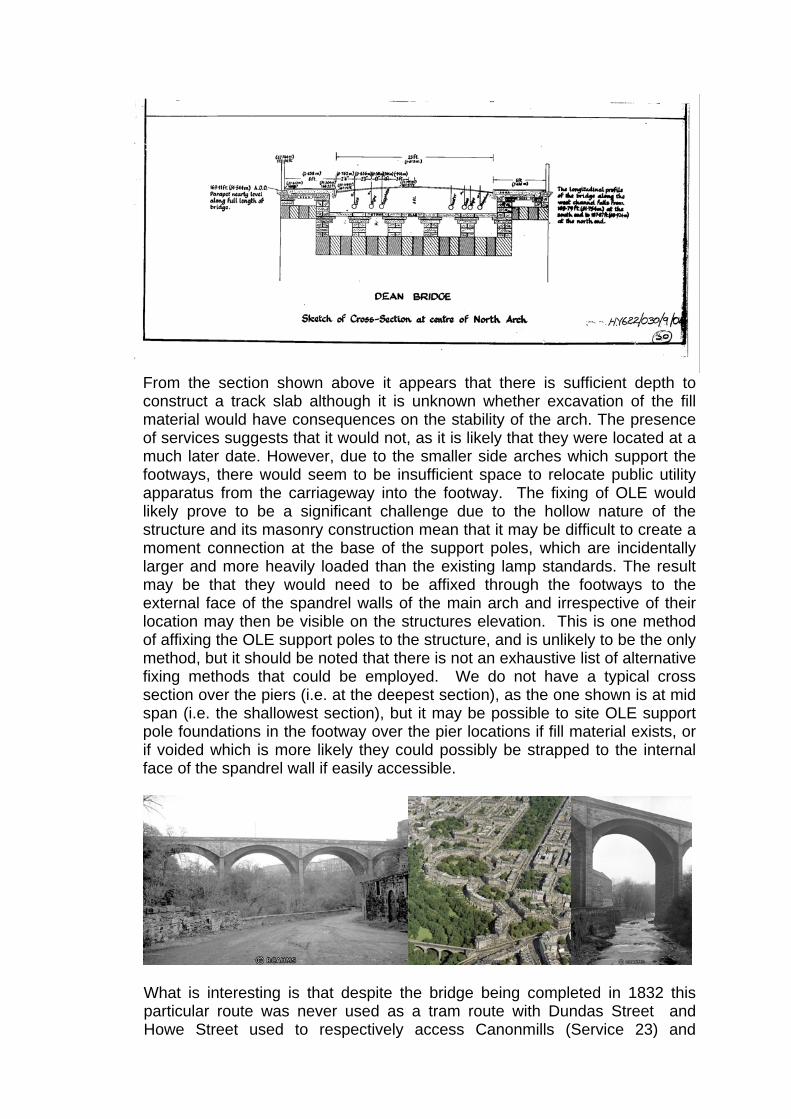
From the section shown above it appears that there is sufficient depth to construct a track slab although it is unknown whether excavation of the fill material would have consequences on the stability of the arch. The presence of services suggests that it would not, as it is likely that they were located at a much later date. However, due to the smaller side arches which support the footways, there would seem to be insufficient space to relocate public utility apparatus from the carriageway into the footway. The fixing of OLE would likely prove to be a significant challenge due to the hollow nature of the structure and its masonry construction mean that it may be difficult to create a moment connection at the base of the support poles, which are incidentally larger and more heavily loaded than the existing lamp standards. The result may be that they would need to be affixed through the footways to the external face of the spandrel walls of the main arch and irrespective of their location may then be visible on the structures elevation. This is one method of affixing the OLE support poles to the structure, and is unlikely to be the only method, but it should be noted that there is not an exhaustive list of alternative fixing methods that could be employed. We do not have a typical cross section over the piers (i.e. at the deepest section), as the one shown is at mid span (i.e. the shallowest section), but it may be possible to site OLE support pole foundations in the footway over the pier locations if fill material exists, or if voided which is more likely they could possibly be strapped to the internal face of the spandrel wall if easily accessible.
What is interesting is that despite the bridge being completed in 1832 this
particular route was never used as a tram route with Dundas Street and Howe Street used to respectively access Canonmills (Service 23) and

Stockbridge and Comely Bank (Service 24) as is shown on the Edinburgh Corporation Transport Department ‘Tram and Bus Routes’ map from 1924. What is also seen interestingly is the emergence of bus services passing across the Dean Bridge (Services 5 & 11). Obviously buses were not in existence in circa 1888 when the cable pulled service in Dundas Street began operating. Patronage is probably the answer to why no tram over the Dean Bridge as the low lying communities adjacent to the Water Leith such as Canonmills and Stockbridge were more developed.
3.28 The Dean Bridge to Randolph Cliff – On site observations indicate that there
is a rapid change in gradient between the bridge and Randolph Cliff which is currently accommodated with an extremely tight vertical sag curve which is unlikely to be negotiable by a tram. In order to ease the curve to a radius which would be acceptable it is likely that the roadway and footway levels would need to be adjusted which is likely to have a consequential impact upon other listed buildings (and their thresholds) including the terrace of properties to the north of Randolph Cliff and Kirkbrae House.
On the southern side of Randolph Cliff there is already a significant level difference between the roadway and footway levels which is compensated by a series of four steps. In addition, there is a decorative island in the centre of the road between the opposing traffic lanes, which is used to remove a further level difference.
3.29 Randolph Cliff/Drumsheugh Gardens Junction – The tram alignment requires
to turn through an approximately 120° 25m radius horizontal curve. Several very basic alignments have indicated that the internal curve would impact upon the properties at 1 & 2 Lynedoch Place which are Grade B listed. It is possible to further develop this alignment by slewing the tracks in Randolph Cliff to the NE and those in Drumsheugh Place to the SE to minimise the impact on 1 & 2 Lynedoch Place but resulting in the tram swept path slewing over nearly the entire width of both roads. The extent of the swept path across both roads will require stop lines to be set back, with few traffic phases if any, able to run independent of the tram phase, leading to long inter-green times and consequent delays and queuing at this strategic junction (Queen Street, Randolph Crescent, Dean Bridge, Queensferry Road and onto the Forth Road Bridge).

3.30 Chester Street to Palmerston Place – This is a right angled junction with
approximately 3m footways to Palmerston Place and approximately 4m and 2m footways to the north and south of Chester Street. The tram alignment requires to turn through a 25m radius horizontal curve, which will require land take from within the grounds of the Cathedral Church of St Mary which is currently a landscaping strip around the periphery of a playground area. This will impact on any coping wall and associated railings, but it is not known if there is any impact on the trees in this landscape strip. Although there is scope to slightly slew the tram alignment, this slewing will not prevent this land take, but merely reduce the affected area marginally. The vertical alignment and gradients are not an issue at this location.
3.31 Palmerston Place to West Maitland Street – This is a right angled junction
with approximately 3m footways to Palmerston Place and West Maitland Street. This basic alignment has indicated that the tram alignment requires to turn through a 25m radius horizontal curve, which would impact upon the property at 1 Palmerston Place. To provide a footway around the NE corner of this junction the property will require at least the demolition of the stepped access to the main entrance and a substitute access provided as well as the basement part infilled or bridged. This will also impact on the coping wall and associated railings. It is possible to further develop this alignment by slewing the tracks in Palmerston Place to the SW and more importantly those in West Maitland Street to the SE to minimise the impact on 1 Palmerston Place but resulting in the tram swept path slewing over a greater width of both roads. In doing so reverse curvature would be introduced on the tramway at this location resulting in a less comfortable manoeuvre to negotiate this junction and avoid any demolition. It is also expected that greater traffic impacts will ensue as a result of slewing the tramway across a wider area of the road. The vertical alignment and gradients are not an issue at this location.
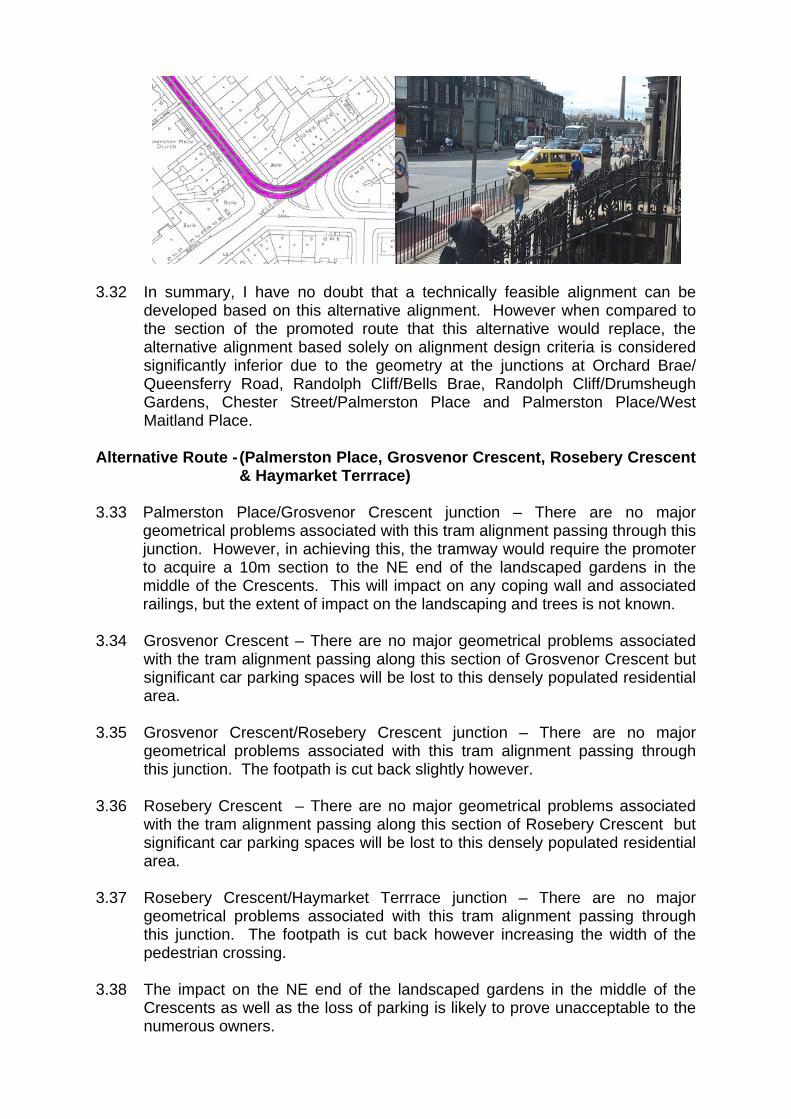
3.32 In summary, I have no doubt that a technically feasible alignment can be
developed based on this alternative alignment. However when compared to the section of the promoted route that this alternative would replace, the alternative alignment based solely on alignment design criteria is considered significantly inferior due to the geometry at the junctions at Orchard Brae/ Queensferry Road, Randolph Cliff/Bells Brae, Randolph Cliff/Drumsheugh Gardens, Chester Street/Palmerston Place and Palmerston Place/West Maitland Place.
Alternative Route - (Palmerston Place, Grosvenor Crescent, Rosebery Crescent
& Haymarket Terrrace) 3.33 Palmerston Place/Grosvenor Crescent junction – There are no major
geometrical problems associated with this tram alignment passing through this junction. However, in achieving this, the tramway would require the promoter to acquire a 10m section to the NE end of the landscaped gardens in the middle of the Crescents. This will impact on any coping wall and associated railings, but the extent of impact on the landscaping and trees is not known.
3.34 Grosvenor Crescent – There are no major geometrical problems associated
with the tram alignment passing along this section of Grosvenor Crescent but significant car parking spaces will be lost to this densely populated residential area.
3.35 Grosvenor Crescent/Rosebery Crescent junction – There are no major
geometrical problems associated with this tram alignment passing through this junction. The footpath is cut back slightly however.
3.36 Rosebery Crescent – There are no major geometrical problems associated
with the tram alignment passing along this section of Rosebery Crescent but significant car parking spaces will be lost to this densely populated residential area.
3.37 Rosebery Crescent/Haymarket Terrrace junction – There are no major
geometrical problems associated with this tram alignment passing through this junction. The footpath is cut back however increasing the width of the pedestrian crossing.
3.38 The impact on the NE end of the landscaped gardens in the middle of the
Crescents as well as the loss of parking is likely to prove unacceptable to the numerous owners.

Alternative Route - (Chester Street, Palmerston Place, Eglinton Crescent,
Coates Gardens & Haymarket Terrrace) 3.39 It should be noted that this alternative alignment will require to connect to
Chester Street as the element using Douglas Gardens and Palmerston Place has already been discounted for technical reasons previously noted.
3.40 Chester Street/Palmerston Place Crescent junction – Despite land take from
within the grounds of the Cathedral Church of St Mary which is currently a landscaping strip around the periphery of a playground area, it is still not possible to connect the back to back reverse 25m radius curves that connects this junction with the Eglinton Crescent junction. This will also impact on any coping wall and associated railings, but the extent of impact on the landscaping and trees is not known. It appears that it is unfeasible to connect these curves (without infilling basements to provide footways which is likely to be unacceptable).
3.41 Palmerston Place/Eglinton Crescent junction – Reference should be made to
Para. 3.40 of this rebuttal. 3.42 Eglinton Crescent – There are no major geometrical problems associated with
the tram alignment passing along this section of Eglinton Crescent but significant car parking spaces will be lost to this densely populated residential area.
3.43 Eglinton Crescent/Coates Gardens junction – There are no major geometrical
problems associated with this tram alignment passing through this junction. 3.44 Coates Gardens – There are no major geometrical problems associated with
the tram alignment passing along this section of Coates Gardens. 3.45 Coates Gardens/Haymarket Terrrace junction – There are no major
geometrical problems associated with this tram alignment passing through this junction. The footpath is cut back however increasing the width of the pedestrian crossing.
3.46 As there are route links which are unfeasible and are critical to this section of
alternative alignment, we have consequently discounted this alignment as it too is considered unfeasible.
Other Issues 3.47 With reference to the WP1 report and while discussing alternative alignments
the following points should also be noted that have become apparent recently as a result of some additional consideration of previously discounted links.
• route link 2–5 which runs from Palmerston Place down Douglas Gardens
to Belford Road from an assessment of spot levels, there is an average gradient of 8.9% between two points just north of the Douglas Gardens and Douglas Crescent junction. This assumes that there is a straight grade between the two spot levels. If that is not the case and there is a

vertical curve anywhere between the two then there will be a point where the gradient exceeds the average of 8.9%. Consequently, this route link can be discounted as it would be in excess of the maximum allowable gradient of 8.0%;
• route link 4-7 which runs from Randolph Cliff to Queensferry Road and
Orchard Brae via Bells Brae and Dean Path, from an assessment of spot levels, there is a gradient of greater than 20% on Bells Brae and greater than 10% on Dean Path. Consequently, this route link can be discounted as it would be in excess of the maximum allowable gradient of 8.0%;
• route link 5–8 which runs from Belford Road to Queensferry Road via
Queensferry Terrace from an assessment of spot levels, there is an average gradient of approximately 7% between two points just north of the Belford Road and Belford Place junction. At this junction the road geometry dictates that this gradient would be co-existent with a horizontal curve of the order of 40m radius. Although the gradient is below the maximum allowable gradient of 8.0% and the combination of horizontal and vertical is on the cusp of being technically feasible, this route link would be considered highly undesirable; and
• route link 6–15 which runs from Queensferry Road to Crewe Toll via
Oxford Terrrace, Comely Bank Terrace, East Fettes Avenue and Ferry road, from an assessment of spot levels, both Oxford Terrrace and Comely Bank Terrace have an average gradient of approximately 7.5% or greater. At the junction of both roads the road geometry dictates that this gradient would be co-existent with a horizontal curve of the order of 25m radius. Although the gradient is below the maximum allowable gradient of 8.0%, the combination of horizontal and vertical is likely to be considered not technically feasible and consequently discounted following more detailed investigation.
3.48 Precedents of tram stops in the UK receiving HMRI approval on gradients
around 5% are there, but are not numerous and should not be what we aspire to. That said and given the precedent, only the southern section of Orchard Brae near its junction with Queensferry Road where it is approximately 6.0% may be considered inappropriate for locating a stop. The most appropriate location for a tram stop on Orchard Brae would be in its northern section near its junction with Crewe Road South where it is approximately 2.0%. In an ideal world and as per the RSPG documents stops should where practical be located on gradients of 0.2% (1 in 500). If stops are situated on gradients in excess of 5% and you wish to ensure access at both ends it is obviously necessary to return the low end ramp (normally folded back on its self i.e. 180°) so that the ramp gradient is no more than 5% (1 in 20) to comply with the provisions of the Disability Discrimination Act. If this is necessary then the width of the stop doubles at that particular location, which would require a minimum footpath width of 8m say, to allow a 2m wide footpath to pass behind the tram stop and folded ramp (Para. 15).
3.49 I disagree that the promoter has had any difficulty aligning the Haymarket
tram stop with Haymarket Station given that the eastern ends of the tram platforms are with a 30m walk distance of the station ticket office, which due

to ticket barriers can not be bypassed. I also disagree with the fact that Palmerston Place ‘is only a short distance from Haymarket Station’. At best with the tram stop platforms an integral part of the West Maitland Street/ Palmerston Place junction (unlikely) the walk distance is some 250m, which is not to dissimilar to the additional walk distance that is deemed unacceptable in relation to the nearest tram stop to the Western General Hospital. In addition, Grosvenor Street has to be crossed before crossing one of the busiest junctions in Edinburgh at Haymarket Terrace (Paras. 20 & 23).
3.50 I disagree that a Palmerston Place stop would be ‘more accessible for those
in wheelchairs, or those who are frail and who might be driven to the tram stop’, as vehicular access is available at Haymarket Yards which would be within 20m of the western ends of the tram stop platforms. I cannot think where in Palmerston Place and West Maitland Street it would more convenient to drop any potential tram patron without potentially impeding either the tram or other traffic (Para. 23).
4. Conclusion 4.1 It is my understanding that City of Edinburgh Council in March 2004 had
consultants investigate the feasibility of converting the Crewe Toll roundabout to a traffic signalled junction. This assessment did not consider the tram passing through the junction. The proposal was discounted as a workable solution could not be developed for traffic. If any alternative tram alignment required to pass through this junction it would be necessary to signalise the junction which adds another order of complexity to developing a solution, which is likely to prove impossible without significant land take and associated property demolition.
4.2 The first alternative alignments that were considered and compared were the
promoted route diverted to Ferry Road then Crewe Toll and the promoted route diverted to Caroline Park Avenue then Crewe Road North and Crewe Toll. In summary, I have serious doubts as to whether a technically feasible alignment can be developed for either of these two alternative alignments, as a result of both having to pass through or over Crewe Toll. However in the eventuality that a technical solution can be developed at Crewe Toll I would, solely on the basis of alignment design criteria, choose the promoted route over the Crewe Road North alternative alignment as it is segregated.
4.3 With reference to the proposed alternative alignment from Orchard Brae to
Palmerston Place via Queensferry Road, Queensferry Terrace, Belford Road, Dean Gallery Car Park, Dean Gallery Grounds, New Water of Leith Bridge and Douglas Gardens. As there are route links which are unfeasible and are critical to this section of alternative alignment, we have consequently discounted this alignment as it too is considered unfeasible.
4.4 With reference to the proposed alternative alignment from Orchard Brae to
West Maitland Place via Queensferry Road, Dean Bridge, Randolph Cliff, Drumsheugh Gardens, Chester Street and Palmerston Place. In summary, I have no doubt that a technically feasible alignment can be developed based on this alternative alignment. However when compared to the section of the promoted route that this alternative would replace, the alternative alignment

based solely on alignment design criteria is considered significantly inferior due to the geometry at the junctions at Orchard Brae/Queensferry Road, Randolph Cliff/Bells Brae, Randolph Cliff/Drumsheugh Gardens, Chester Street/Palmerston Place and Palmerston Place/West Maitland Place.
4.5 With reference to the proposed alternative alignment from Palmerston Place
to Haymarket Terrrace via Grosvenor Crescent and Rosebery Crescent. The impact on the NE end of the landscaped gardens in the middle of the Grosvenor and Lansdowne Crescents as well as the loss of parking is likely to prove unacceptable to the numerous owners.
4.6 With reference to the proposed alternative alignment from Chester Street to
Haymarket Terrrace via Palmerston Place, Eglinton Crescent and Coates Gardens. As there are route links which are unfeasible and are critical to this section of alternative alignment, we have consequently discounted this alignment as it too is considered unfeasible
4.7 Therefore when the pieces of this alternative alignment jigsaw are assembled
to form a complete route for comparison with the promoted route the alternative alignment reads from the north West Granton Access Road (promoted route), Ferry Road, Crewe Toll, Crewe Road South, Orchard Brae, Queensferry Road, Dean Bridge, Randolph Cliff, Drumsheugh Gardens, Chester Street, Palmerston Place and West Maitland Place (promoted route). In summary, I have no doubt that a technically feasible alignment can be developed based on this alternative alignment. However when compared to the section of the promoted route that this alternative would replace, the alternative alignment based solely on alignment design criteria is considered significantly inferior due to the technical difficulties and challenges that affect the majority of junctions listed above in this paragraph.
4.8 From some recent additional consideration of previously discounted links
which were assessed in the WP1 report, I can confirm that route links 2-5, 4-7 & 6-15 are not technically feasible while route link 5-8 is considered highly undesirable.
4.9 Precedents of tram stops in the UK receiving HMRI approval on gradients
around 5% are there, but are not numerous and should not be what we aspire to. That said and given the precedent, only the southern section of Orchard Brae near its junction with Queensferry Road where it is approximately 6.0% may be considered inappropriate for locating a stop. The most appropriate location for a tram stop on Orchard Brae would be in its northern section near its junction with Crewe Road South where it is approximately 2.0%.
4.10 I disagree that the promoter has had any difficulty aligning the Haymarket
tram stop with Haymarket Station given that the eastern ends of the tram platforms are with a 30m walk distance of the station ticket office, which due to ticket barriers can not be bypassed. I also disagree with the fact that Palmerston Place ‘is only a short distance from Haymarket Station’. At best with the tram stop platforms an integral part of the West Maitland Street/ Palmerston Place junction (unlikely) the walk distance is some 250m, which is not to dissimilar to the additional walk distance that is deemed unacceptable in relation to the nearest tram stop to the Western General Hospital. In

addition, Grosvenor Street has to be crossed before crossing one of the busiest junctions in Edinburgh at Haymarket Terrace.
4.11 I disagree that a Palmerston Place stop would be ‘more accessible for those
in wheelchairs, or those who are frail and who might be driven to the tram stop’, as vehicular access is available at Haymarket Yards which would be within 20m of the western ends of the tram stop platforms. I cannot think where in Palmerston Place and West Maitland Street it would more convenient to drop any potential tram patron without potentially impeding either the tram or other traffic.
Mark M Bain Senior Engineer Mott MacDonald 12 August 2005

GROUP 45 ROSEBURN CORRIDOR
REBUTTAL TO WITNESS STATEMENTS OF T WOOLNOUGH PROMOTER REBUTTAL BY STUART TUNBULL 1 Background 1.1 In this Rebuttal Statement I comment on the traffic and congestion
issues raised in the Witness Statement of T Woolnough for Group 45. 2 Agreed Issues 2.1 There are no noteworthy agreed issues that have been raised in relation
to my area of expertise. 3 Issues in Dispute 3.1 In the paragraphs below I cover firstly the three main options considered
by the promoter in this locality and comment further on the traffic related issues. I then cover the additional route options proposed by the various objectors, again commenting on the traffic related issues.
Promoters Route selection
3.2 I have provided comment on the traffic impacts of the various routes
considered by the promoter after the work package one report within Section 4 of my witness statement. I would further comment as follows in relation to Route Option B (Telford Road) and Options C1 and C2 (Craigleith Road / Crewe Road South).
Route Option B (Telford Road)
3.3 I would refer to paragraph 4.7 my witness statement, which states:
“The Telford Road option would avoid the congested junction at Crewe Toll and, in general, result in less interaction with general traffic. However there would still be the need to modify four junctions along the route and, as described above, it is unlikely that the tram would achieve full priority through these junctions. Although detailed modelling of these junctions has not been undertaken at this stage I would estimate that on average the additional delays caused to the tram vehicle as it travels through these junctions would be approximately 30 seconds. It should be noted that these delays were not taken into account on the patronage assessments for the Telford Road option. If these delays were taken into account the predicted run times would increase and the patronage levels may decrease. The route along the Railway Corridor would suffer no such delays.”

Route Options C1 and C2 (Craigleith Road / Crewe Road South) 3.4 The Craigleith route would involve a significant element of on-street
running and interaction with a number of busy junctions en-route, in particular:
• Craigleith Road/Queensferry Road junction; • Craigleith Road/Crewe Road South junction; and • Crewe Toll junction.
3.5 Wherever practicable, it is the promoter’s aim to maximise the extent (chainage) of segregation from other road users when trams operate within a road carriageway. Therefore in relation to Craigleith Road it was considered that the optimum layout would be to incorporate segregated tram operations which are possible within the available land. Reference should be made to the rebuttal of my colleague Mr Bain for further details of this.
3.6 Notwithstanding, the levels of traffic demand and the layout of the
junction of Craigleith Road/Queensferry Road, Craigleith Road/Crewe Road South and Crewe Toll are such that that there remain a number of technical difficulties associated in accommodating a tram, particularly compared to the option of running on the segregated former railway corridor. My colleague Mr Bain in his Witness Statement and Rebuttal has covered the alignment related issues. In the paragraphs below I comment further on the traffic related issues:
3.7 Craigleith Road/Queensferry Road junction. This traffic signal
controlled junction, which also provides access to the Craigleith Retail Park, a petrol filling station and hotel, offers the following difficulties with respect to the introduction of tram:
• Reduction in stopline capacity on Craigleith Road approach to the
junction, as a result of the introduction of a tram; • Reconfiguration of the traffic signal staging to accommodate the
tram. This would result in the requirement to provide additional stages to accommodate all vehicle movements within the junction at the expense of junction capacity;
• The existing access to the retail park, located on South Groathill Avenue, would require the introduction of traffic signal control, linked to the Craigleith Road / Queensferry Road junction. Such an arrangement may result in a queue developing on South Groathill Avenue, blocking back onto the Queensferry Road junction. The management of this queue would require to take precedence over tram priority at this location, in order to reduce impact on the A90 through movements.
3.8 Figure 1 below illustrates the existing junction arrangement with the
introduction of the tram alignment.

Figure 1 –Queensferry Road / Craigleith Road with Option C Tram Alignment
3.9 Craigleith Road/Crewe Road South junction. An outline design and
assessment of the Craigleith Road / Crewe Road South junction has demonstrated that the following issues would arise: • Closure of Orchard Road to form a four-arm traffic signal controlled
junction. The retention of Orchard Road within the reconfigured junction would introduce operational difficulties, and introduce delay to the main approaches.
• Reduction in junction capacity as a result of introduction of single traffic lane approaches on Crewe Road South and Craigleith Avenue, required in order to accommodate Tram.
• Traffic on Orchard Brae, Craigleith Road and Comely Bank Road and pedestrians would require to be stopped to allow Tram to progress through the junction in either direction;
• Queuing predicted on all arms to the junction 3.10 An illustration of the typical junction arrangement that would be required
to accommodate tram is shown in Figure 2 below.

Figure 2 – Indicative Junction Layout Crewe Road South / Orchard Brae 3.11 Crewe Toll junction. A study commissioned by The City of Edinburgh
Council to investigate the introduction of traffic signal control at Crewe Toll, identified a number of difficulties in delivering such an improvement,
3.12 In terms of junction capacity, the assessment illustrated that queues and
delays would be experienced on Crewe Road South with an average queue of 40 vehicles during the 2011 weekday evening peak period.
3.13 This queuing traffic would require to be allowed to progress through the
signals in advance of the trams approach to Crewe Toll to ensure tram priority was maintained. Such an arrangement would have an adverse impact on the capacity of the remaining approaches to the junction, namely Telford Road and Ferry Road.
3.14 An illustration of the typical junction arrangement that would be required
to accommodate tram is shown in Figure 3 below.
Figure 3 – Indicative Junction Layout Crewe Toll

3.15 As outlined in paragraph 4.3 of my witness statement, in traffic terms a solution may be possible to introduce tram into the Crewe Toll and Craigleith Avenue corridors, though at the expense of other road users.
3.16 In summary therefore I believe that on traffic grounds the promoted
route has clear advantages over the Telford Road and Craigleith options in that:
• the alternative alignment has ten minor traffic junctions to negotiate
when compared to none on the promoted route; • the alternative alignment has four major traffic junctions to negotiate
when compared to none on the promoted route.
Objectors Route Options 3.17 A number of alternative routes have been promoted by the objectors
including:-
• Crewe Road South, Orchard Brae, Queensferry Road, Drumsheugh Gardens, Chester Street and Palmerston Place; and
• Crewe Road South, Orchard Brae, Queensferry Road, Queensferry Terrace, Belford Road, Douglas Gardens, Palmerston Place.
3.18 The above routes were considered as part of work package 1 and my
colleague Mr Andrew Oldfield, has covered the route selection process within his witness statement.
3.19 In terms of traffic integration, I would refer to paragraph 3.3. of my
witness statement “…..In traffic terms the routing of the tram along on-street sections is clearly less desirable than the option of segregated running”.
3.20 The areas of particular concern in traffic interface terms are:
• Impact on parking resulting from running on Belford Road; • Impact on traffic and levels of congestion resulting from running
along Queensferry Road, as opposed to the promoted route through the former rail corridor;
• Need for turning manoeuvres for tram at a number of junctions, impacting on operation of the junction at the following locations:
o Orchard Brae/Queensferry Road; o Queensferry Road/Drumsheugh Gardens; o Chester Street/Palmerston Place; o Palmerston Place/West Maitland Street; o Queensferry Road/Belford Road; and o Douglas Gardens/Belford Road.
• Introduction of traffic signal control at a number of existing priority controlled junctions introducing delay to other road users.

4 Conclusion 4.1 Based on the evidence presented in my witness statement and the
points outlined above, it is considered that in comparison to all options the route shown in blue in Figure 4.1 of my witness statement, using the former railway corridor, is clearly the optimum route in traffic terms.
Stuart Turnbull 12 August 2005