Embed Size (px)
Citation preview

GSA Data Repository item 2007216
The influence of large landslides on river incision in a transient landscape: Eastern
margin of the Tibetan Plateau (Sichuan, China)
William B. Ouimet
GSA Bulletin; doi: 10.1130/B26136.1
DR2007216

GSA Bulletin Data Repository for: “The Influence of Large Landslides on River Incision in a
Transient Landscape: Eastern Margin of the Tibetan Plateau (Sichuan, China)” by William B.
Ouimet, Kelin X. Whipple, Leigh H. Royden, Zhiming Sun and Zhiliang Chen
• Field Photos
• Additional Case Studies
• Additional information for Case Studies 1 and 2 (presented in main text)
• Figures DR-1, DR-2, DR-3, DR-4, DR-5, DR-6 and DR-7
• References and Figure Captions
-------------------------------------------------------------------------------------------------------------------
FIELD PHOTOS
Figures DR-1 and DR-2 contain field photos of large landslide surfaces/deposits, typical
landslide rapids associated with active landslide dams, and examples of bedrock and alluvial
river channels within river gorges on the eastern margin of the Tibetan plateau.
ADDITIONAL CASE STUDIES
Field work was focused along the trunk streams and major tributaries of the Dadu and
Yalong Rivers, with limited time spent studying the Min River to the east of the Dadu River and
the Yangtze River to the west of the Yalong River. Field observations of both active landslide
dam sites and inferred sites of landslide dams that existed in the past were prevalent in all rivers
gorges studied. Here, we provide additional, illustrative examples from within the Min, Dadu
and Yalong river gorges that further highlight the interaction between landslide dams, channel
morphology, longitudinal river profiles, and river incision on the eastern margin of the Tibetan
plateau.
Min River: Deixi Landslides -- 32.05° N, 103.679° E
One well-documented, recent example of the powerful influence of landslides is the
Deixi slide on the Min River to the east of the Dadu River (Fig. DR-3). It is the best modern
analog of an active stable landslide dam on the eastern margin. Three landslide dams formed
following a magnitude 7.5 earthquake in 1933 (Costa and Schuster, 1988; Tianchi, 1990). The
material that composes the lower two landslide dams was derived from a pre-existing landslide
1
DR2007216

deposit an order of magnitude larger in volume than the 1933 landslide masses (Fig. DR-3). This
older landslide dammed the Min River ~14,000 years ago, based on the age of lake sediments
preserved upstream (Kirby et al., 2002). In the 1933 event, the downstream dam failed
catastrophically days after the earthquake, while the upper two did not. These upper two dams
continue block the Min River today, having formed large lakes that continue to fill with sediment
(Fig. DR-3). The upper most dam, the Yinping landslide blockage, is composed of course rock-
avalanche deposits and obstructs a relatively narrow bedrock gorge. The top of the Yinping
blockage sits 150 m high above the pre-1933 bedrock valley floor, and in the 73 years since the
earthquake, the landslide deposits have not incised or eroded significantly. The lake upstream,
which was reportedly 10 to 11 km long months after the earthquake, is presently 6 km long with
an active delta front of alluvial gravel pro-grading towards the dam (Fig. DR-3ii).
Middle Dadu Gorge
We define the middle Dadu gorge as the stretch of river between 30.3° to 29.6° north
latitude as the Dadu River flows south. This stretch of river is mainly an alluvial reach, with the
Dadu meandering through a wide valley 500-1000 m across filled with large alluvial/debris-flow
fan material entering from large side tributaries and the deposits and landforms of large
landslides (Figs. DR-4 and DR-5). This stretch of river is bounded on its northern and southern
ends by distinct bedrock reaches of the Dadu, which have no large landslides within them. The
middle Dadu gorge shows no signs of active incision into bedrock; there is no bedrock
outcropping within the channel or channel banks, and no strath terraces. The Dadu valley
throughout the middle gorge is trying to rework old landslide deposits and reached its bedrock
valley floor.
The middle Dadu gorge has the largest and most dramatic examples of landslide deposits
of anywhere within the Dadu catchment. One particular set of surfaces, called the Luding
terraces, record an immense landslide event that crossed and blocked the entire Dadu River
valley, and a lake that once existed high above the city of Luding (Figs. DR-5a, 5b, and 5c).
South of Luding, distinct landslide masses sit ~700m above the modern river level on both sides
of the valley, the eastern of which has a cut-landslide fill terrace half way down. Above Luding,
upstream of these landslide deposits, a package of lake sediments ~200m thick sits ~900 m
above the present river elevation on top of bedrock. These lake sediments were deposited by the
2
DR2007216

Dadu or a side tributary in landslide dammed lake that probably existed more than a million
years ago (Chen et al, 2005). The age estimate is based on magneto-stratigraphy work done
within the lake sediments, showing at least one magnetic reversal and correlating the sequence to
an age of ~4.4 million years (Fuchu et al., 1999). However, because the authors failed to account
for significant slumping and deformation within the section, it cannot be confirmed that reversals
recorded were not simply one reversal repeating itself within the sequence. In any case, because
these deposits sit on bedrock, the Luding terraces demonstrate that landslide damming events
occurred when the Dadu trunk level was higher than it is today, and that the relicts of landslide
damming events often persist high up on valley walls for thousands or even millions of years.
South of Luding, ~20 km, another notable landslide area has a large volume of landslide
debris on both sides of the river valley, with the highest landslide surface resting ~450 m above
the present river level (see photos, Figs. DR-1c, DR-5d and DR-5g). Incision into the landslide
debris has cut large terrace levels within the original landslide deposit. The bottom of these
surfaces is landslide material, there is no bedrock, indicating two things: (1) that this landslide
complex is younger than the Luding landslide complex, because this complex occurred when the
bedrock floor of the middle Dadu gorge was lower than it was at the time of the Luding
landslides, and (2) that the Dadu is still reworking the landslide material here and is actively
dammed. Age constraints confirm that this landslide complex is young, at least 6,535 +/- 460
years old. This age is from cosmogenic radionuclide (10Be) exposure age dating of a large, ~8 m
diameter boulder on top of the landslide deposit. The boulder rests ~200 m above the modern
river level, yielding a time-averaged landslide dam erosion rate of ~3.06 +/- 0.22 mm/yr. The
hummocky landslide surface where the sampled boulder rests half buried has been farmed, with
possibly up to 2 meters of rock/soil missing. As a result, the age of the landslide should be
considered a minimum, making the time-averaged landslide dam erosion rate a maximum.
Through the landslide deposits in this area, the Dadu River experiences a significant steepening
through the boulder rapids that occur as the river incises into landslide debris.
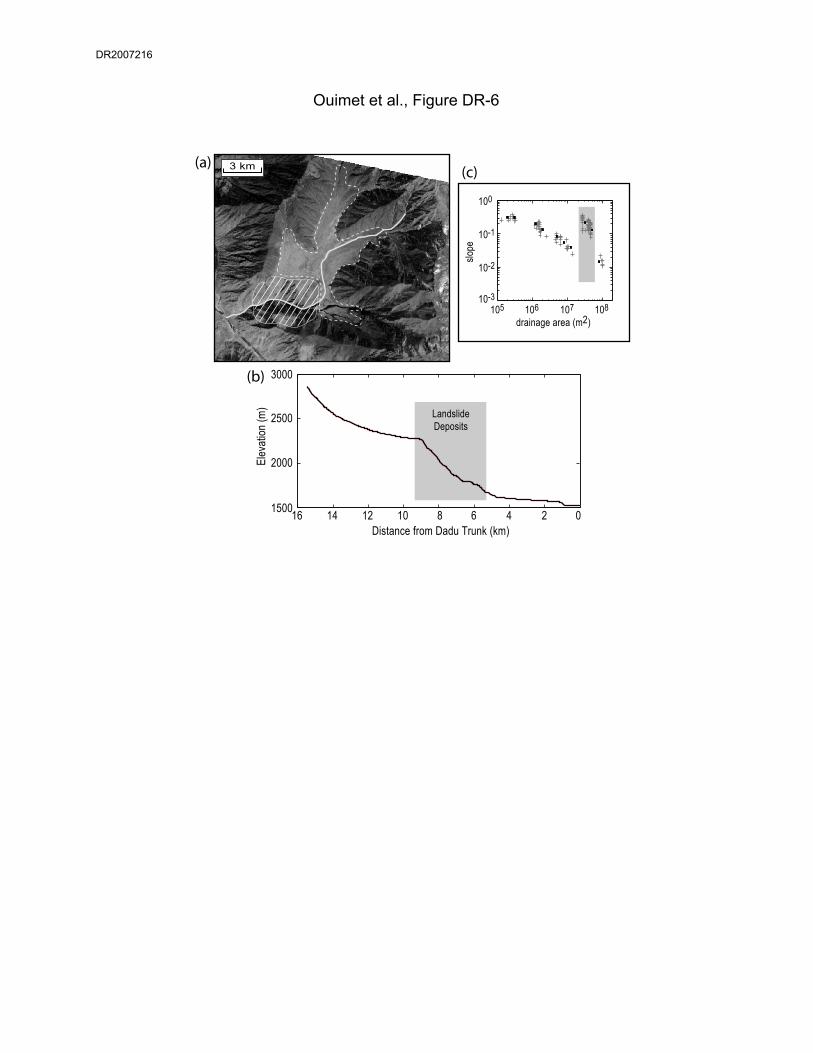
One final landslide example worth noting in the middle Dadu gorge is within a small side
tributary of the Dadu north of Luding (Fig. DR-6). This tributary, which enters from the east, is
completely back-filled with sediment behind the landslide dam that occurs close to the Dadu.
The longitudinal profile of this tributary has a pronounced knickpoint, with characteristic
increase in channel steepness through the landslide deposits (Fig. DR-6c). Very different
3
DR2007216

interpretations would have been possible for this tributary, such as a fluvial hanging valley, trunk
down-cutting and subsequent knickpoint incision migrating upstream, or the outcropping of
particularly resistant lithology control.
In general, examples where deposits from large landslide dams fill the middle Dadu
gorge, there are no significant knickpoints on the longitudinal profile of the Dadu River. Rather,
the channel within the middle dadu gorge is steeper than average, suggesting that the integrated
effects of incising into landslide deposits has steepened the long-term river profile, but do not
cause a distinct knickpoint in the full profile of the Dadu.
Dadu Gorge: Confluence of Mar Qu and Do Qu Tributaries
The confluence of Mar Qu and Do Qu tributaries of the Dadu occurs within the upper
Dadu gorge, west of Barkum (also Ma’erkang) in Jinchuan country (Fig. DR-7). Here, another
dramatic example of a landslide dam occurs along the main Dadu River profile, where the two
main tributaries of the upper Dadu catchment join (the Mar Qu and Do Qu), each dissecting the
granite intrusion which encircles their confluence. The main Dadu branch (Mar Qu), which
enters this confluence from the east, has a significant landslide dam. In 5 km, the channel drops
~75 m as the river works its way through a landslide package with coarse granite boulders 1-2 m
in diameter (Fig. DR-7). Upstream, lake sediments and alluvial fill are preserved and the Dadu
River is dammed for ~12 km. The age of the landslide deposit is 56,944 +/- 3,858 years, based
on a cosmogenic radionuclide (10Be) exposure age for a large, 5 m diameter boulder on top of the
landslide deposit. The boulder we dated rests ~105 m above the modern river level, yielding a
time-averaged landslide dam erosion rate of ~1.84 +/- 0.12 mm/yr. This landslide dam occurs
along a stretch of river already over-steepened because of the lithologic contrast between flysch
to the North and South and a massive granitic intrusion. Two reaches of boulder rapids occur at
large rockfalls upstream on the Mar Qu, and downstream after the confluence, both within the
granite.
Yalong Gorge
Our ability to extensively study the Yalong River gorge in the field has been limited by
access. Much of the Yalong gorge lies within a deep, extremely steep gorge without roads.
The only significant landslide dam within the Yalong river gorge documented in the field occurs
4
DR2007216

1km downstream of the Li Qui/Yalong River confluence (Fig. DR-1e). Here, a dam of unknown
age occurs with ~40 m of drop in the rapids, upstream of which the Yalong is dammed for ~10
km. Further downstream, the Yalong river has two large-scale knickpoints on its longitudinal
profile (Fig. 2). Although we were not able to visit these sites in the field, analysis of bedrock
geology maps and satellite imagery strongly suggests that these knickpoints are landslide related.
The hillslope morphology of large landslides is identified, and granite plutons outcrop adjacent
to the Yalong gorge, in contrast with reaches to the north and south which lie within
predominantly flysch bedrock. It appears as though the combination of large landslides and
massive granite boulders in this reach contribute to the large knickpoints seen on the Yalong
profile, similar to the lower portion of the Li Qui River.
ADDITIONAL INFORMATION FOR CASE STUDIES PRESENTED IN MAIN TEXT
Case Study 1: Dadu Gorge and Tributaries - Danba Region
As exemplified by the Ge Sud Za example (Fig. 5), rivers around Danba appear strongly
influenced by large landslides and are detached from their bedrock valley floors, with no
indication of quick incision into landslide-related deposits, or, a return to steady incision into
bedrock. North of Danba, the western valley wall consists of a large complex of landslides. This
area has many landslide scarps, indicating continual reactivation of the landslide debris. The
most recent reactivation has produced a large landslide dam on the Dadu (Fig. 4, photo DR-1g).
The dam is ~9 km upstream from the town of Danba, and has ~80 m of drop in the rapids caused
by the landslide deposits. This is largest direct drop on the Dadu mainstem associated with a
single, active landslide dam. Upstream of the dam, the channel meanders through a valley filled
with alluvial gravel for ~10 km. Farther north of this landslide dam (~28 km upstream of
Danba), the Dadu dissects a granitic pluton which outcrops to the NW and SE of the river. The
general steepening seen in the Dadu profile within this granite section is associated with two
large landslide complexes and debris flow fans which enter from side tributaries (Fig. 4). Within
the 90 km of river channel upstream of this granite section, the Dadu mainstem contains no
active landslide dams and is gentle and alluvial, suggesting that it is hung up and dammed behind
the landslide complexes associated with this granitic body.
The Xiaojin Chaun tributary has two significant landslide dams, the biggest of which is
~17 km upstream from the confluence with the Dadu with ~100 m of drop in the rapids caused
5
DR2007216

by the landslide deposits (Fig. 4). The landslide occurred on the SE of the valley and landslide
debris has pinned the channel against the NW bedrock valley wall. Rapids through this landslide
dam are now caused by large landslide boulders and the abraded, sculpted bedrock wall.
Upstream, the valley is filled for ~17 km, but side tributaries have not yet built large alluvial fans
upon the fill level, suggesting that it is considerably younger than the biggest example on the Ge
Sud Za He (i.e., << 9000 yrs old). Finally, the Dong Gu He tributary has one significant
landslide dam, with ~60 m of drop in the rapids caused by the landslide deposits, which consist
of large, 5-10 m boulders. This dam on the Dong Gu He tributary occurs at a drainage area
much less than the examples on the Xiaojin Chaun and Ge Sud Ze He tributaries, and as a result,
the channel gradient is much steeper and the upstream filling behind the dam does not extentd
more than 2-3 km.
Case Study 2: Li Qui River
The Li Qui example emphasizes the influence of local sediment flux from hillslopes on
controlling river gradients, and stresses the role of grain size and lithology. Steep river gradients
will persist wherever the adjacent hillslope lithology is massive enough to deliver coarse
boulders to the channel, regardless of the hillslope erosion process responsible for their
deposition (debris flow, rockfall, large landslide, etc.). For most of its length, the Li Qui cuts
flysch, but three granite intrusions lie along the profile (Fig. 6b). The river dissects the upper
and middle granite intrusions, and lies just to the south of the lower granite intrusion. The upper
granite intrusion defines a sharp knickpoint on the longitudinal profile of the Li Qui, with
bedrock occasionally outcropping in the channel (profile location A in Fig. 6c). The channel
itself is a continuous boulder cascade composed primarily of 1 to 3 m granite boulders. The
processes delivering these boulders to the channel are most likely periglacial weathering of
bedrock outcrops on adjacent hillslopes, small rockfalls, and other mass wasting processes. In
contrast, the middle granite intrusion does not have a morphologic expression in the longitudinal
profile (profile location B in Fig. 6c). The channel here contains less than 1% granite boulders,
and the Li Qui river valley is wide and alluviated, suggesting the possibility that a knickpoint on
the bedrock valley floor is buried beneath the fill. The lower granite intrusion coincides with the
dramatic steepening of the profile as it falls to join the Yalong (profile location C in Fig. 6c).
Here, massive granite does not outcrop directly in the channel or adjacent hillslopes, but it does
6
DR2007216

outcrop high up on the valley walls. The large boulders seen in the channel armoring the bed are
granite, presumably delivered to the channel from rockfalls and landslides.
Figure 6d shows that well-preserved lake and alluvial fill gravels record a period of
prolonged river damming on the Li Qui and the river has subsequently incised into a portion
these sediments. The highest fill level increases in height moving downstream and wide-spread
landslide deposits indicate the likely site of an ancestral landslide dam. This is also where all
outcrops of incised sediments end. Within the 50 km of incised sediment behind the ancestral
landslide dam site (Fig. 6d), we have dated lake sediments in three locations and the alluvial
gravels in two locations. The lake sediment dates are Optically Stimulated Luminescence (OSL)
ages from quartz grains, intended to constrain the time when these fine sediments were deposited
in a lake environment. The three ages are 4,214 +/- 605, 5,030 +/- 950, and 7,780 +/- 1,200
years old. The two alluvial gravel ages are from cosmogenic radionuclide (10Be) depth profiles,
intended to constrain the time the timing of abandonment of fill terraces. We interpret these fill
terraces to represent the active river level at the time the Li Qui River was adjusted (or graded) to
a base-level fixed at the top of a landslide dam downstream. We sampled this paleo-Li Qui
River level in two places: upstream where the fill terrace level is ~17 m above the modern river
level, and downstream where the fill terrace level is ~60 m above the modern river level. The
upstream age is 7,935 +/- 785 years old and the downstream age is 4000 +/- 215 years old.
Depending on what we assume about the post-depositional history of the fill terraces, the timing
of abandonment in relation to one another, or the inherent uncertainty of dating lake sediments
with OSL, we can use these ages to say that these sediments were deposited behind one landslide
dam sometime between 4000 and 8000 years ago (deposited over a period of ~1000 years), or
two landslides dams, one ~5000 years ago and the other ~8000 yrs ago. Either way, since the
river is still reworking and incising into these sediments and has not reached the bedrock valley
floor, they indicate that landslides have dominated this stretch of river for at least the last ~8000
years, and perhaps much longer.
ACKNOWLEDGEMENTS
Work supported by the NSF Continental Dynamics program (EAR-0003571), in collaboration
with the Chengdu Institute of Geology and Mineral Resources. Thanks to Joel Johnson, Jamon
Frostenson, Tang Fawei, and Miu Guoxia for assistance in the field; Shannon Mahon for help
7
DR2007216

with preliminary OSL dates; and Darryl Granger, Tom Clifton, Andy Cyr, Marc Caffee and the
Purdue PRIME Lab staff for help with cosmogenic analysis.
REFERENCES:
Chen, Z., Sun, Z., Royden, L., and Zhang, X., 2004, “Landslide Blocked Lake: Origin of the
Xigeda Formation in Luding, Sichuan and its Significance”, Chinese Academy of Geology,
Beijing, China (in Chinese).
Costa, J.E., and Schuster, R.L., 1988, The formation and failure of natural dams, Geological
Society of America Bulletin, v. 100, p. 1054-1068.
Fuchu, J., Xihao, W. and Huaguo, X., 1999, “Luding Xigeda Epoch and Lifting of the Western
Sichuan Plateau”, Chinese Academy of Geology, Beijing, China (in Chinese).
Kirby, E. , Burchfiel, B.C., Whipple, K.X., Tang, W., Berger, G., Sun, Z., and Chen, Z., 2000,
“Neotectonics of the Min Shan, China: Implications for mechanisms driving Quaternary
deformation along the eastern margin of the Tibetan Plateau”, GSA Bulletin, v. 112, pp. 375-
393.
Tianchi, L., 1990, Landslide management in the mountain areas of China: ICIMOD Occasional
Paper No. 15, Kathmandu, Nepal.
FIGURE CAPTIONS:
Figure DR-1: Field photos of large landslide surfaces/deposits and steep, narrow boulder rapids
through landslides deposits: (a) Dadu River, north of Danba; (b) Min River, west of Maowen;
(c) Dadu River, south of Luding; (d) Dadu River, north of Jinchuan; (e) Yalong River, south of
Li Qui confluence; (f) Li Qui River, ~3 km from its confluence with the Yalong River; (g) Dadu
River, north of Danba.
Figure DR-2: Field photos of bedrock and alluvial river channels within the Yalong and Dadu
River catchments, showing the highly variable nature of channel and valley widths. (a) Alluvial
reach, Dadu River, south of Jinchuan; (b) Alluvial reach, Dadu River, 100 km downstream of
Luding; (c) Alluvial reach, Dadu River, Luding area; (d) Bedrock reach, Yalong River, north of
Yajiang. (e) Bedrock reach and landslide rapids, Dadu River, north of Danba; (f) Bedrock reach,
Dadu River, north of Luding; (g) Bedrock reach, Yalong River, south of Yajiang.
8
DR2007216

Figure DR-3: Deixi Landslides on the Min River (32.05° N, 103.679° E). (a) River profile
through the landslide dams. Coarsely dashed box denotes the older, ~14,000 year old landslide
deposits; smaller, more finely dashed boxes denote the landslide deposits which dammed the
Min River in 1933. (b) Map of the Deixi area with 1933 landslide scars (bold black lines with
teeth) and landslide dam (gray shading) indicated. Landslide scars associated with the older,
~14,000 year old landslide deposits noted as gray lines with teeth. Note locations of photos (i),
(ii) and (iii). (i) Photo of the upper landslide dam: the Yinping blockage. (ii) Photo of the active
delta front of alluvial gravel pro-grading into the lake. (iii) Photo of the older, ~14,000 year old
landslide deposits.
Figure DR-4: Map of the middle Dadu gorge between 30.3° to 29.6° N as the Dadu River flows
south. Landslide scars (bold black lines with teeth), and inferred landslide dams (gray shading)
indicated. Dashed gray line indicates the Luding terrace composed of lake sediments 900 m
above the present Dadu level. Markers (a) through (g) denote the locations of field photos in
Figure DR-5.
Figure DR-5: Field photos from the middle Dadu gorge region. (a), (b) Luding terraces,
landslide deposits downstream of Luding; (c) Luding terrace, lake sediments above Luding; (d),
(g) Landslide complex 20 km south of Luding; (e) Landslide scar and surface, south of Luding;
(f) Landslide deposits, north of Luding.
Figure DR-6: North of Luding, small tributary of Dadu completely filled behind landslide dam.
(a) ASTER satellite image, resolution 15 m, visible bands 1, 2 and 3. Area filled with white bars
indicates the extent of landslide deposits and associated dam. Dashed line outlines the extent of
filled valley upstream of landslide dam. (b) Longitudinal river profile extracted from 30 m DEM
derived from the ASTER imagery. (c) Slope-Area data for the profile. Note the large knickpoint
and extremely high channel steepness values through the landslide deposit.
Figure DR-7: (a) Map of the confluence of Mar Qu and Do Qu Tributaries (31.8373° N,
101.9181° E). Landslide scar (bold black lines with teeth) and landslide dam (gray shading)
9
DR2007216

10
indicated. Note locations of photos (i) and (ii). White star marks the location of the landslide
boulder we dated to 56,944 +/- 3,858 years old. (b) River profile through the landslide dam.
DR2007216

Ouimet et al., Figure DR-1
a
c
d
b
fe
g
DR2007216

Ouimet et al., Figure DR-2
a
c
d
b
fe g
DR2007216

1900
2100
2300
2500
0 10 20 30 40Distance (km)
Ele
vatio
n (m
)
Min
R.
Min
R.
Tributary
N
4 km
i
ii
iii
i
ii
iii
Ouimet et al., Figure DR-3
(a)
(b)
DR2007216

M
oxi Gou H
e
Wa Si He
10 km
102 10' E
30 1
0' N
1100 m
Luding
Dadu He
N
1500 m
Dadu He
102 10' E
30 0
' N29
50'
N29
40'
N
30 1
0' N
30 0
' N29
50'
N29
40'
N
Da du
He
Fig. DR-5
Ouimet et al., Figure DR-4
a
c
b
d
e
g
f
DR2007216

Ouimet et al., Figure DR-5
a
c
b
d
eg
f
DR2007216
02468101214161500
2000
2500
3000
Distance from Dadu Trunk (km)
LandslideDeposits
3 km
Elev
ation
(m)
106drainage area (m2)
slope
(a)
(b)
(c)
Ouimet et al., Figure DR-6
107 108105
100
10-1
10-2
10-3
DR2007216

Distance (km)
Ele
vatio
n (m
)
2100
2200
2300
2400
2500
0 5 10 15 20 25 30
Ouimet et al., Figure DR-7
Do Qu
Dadu He
N4 km
Mar Q u (D
adu)
2380 m
2220 m
i
ii
i ii
(a)
(b)
DR2007216