Embed Size (px)
Citation preview

NCHRP Web Document 43 (Project 25-10[2]): Contractor’s PowerPoint Presentation
Guidance for Estimating the Indirect Effects of Proposed
Transportation Projects
Part 2 of 2: Supporting Materials
Prepared for: National Cooperative Highway Research Program
Transportation Research Board National Research Council
Submitted by: The Louis Berger Group, Inc.
East Orange, New Jersey
May 2002

ACKNOWLEDGMENT This work was sponsored by the American Association of State Highway and Transportation Officials (AASHTO), in cooperation with the Federal Highway Administration, and was conducted in the National Cooperative Highway Research Program (NCHRP), which is administered by the Transportation Research Board (TRB) of the National Research Council.
DISCLAIMER The opinion and conclusions expressed or implied in the report are those of the research agency. They are not necessarily those of the TRB, the National Research Council, AASHTO, or the U.S. Government. This report has not been edited by TRB.

CASE STUDY SCENARIO AIRPORT ACCESS IMPROVEMENT
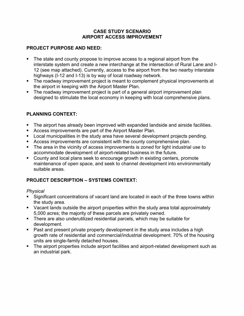
CASE STUDY SCENARIO AIRPORT ACCESS IMPROVEMENT
PROJECT PURPOSE AND NEED: ��The state and county propose to improve access to a regional airport from the
interstate system and create a new interchange at the intersection of Rural Lane and I-12 (see map attached). Currently, access to the airport from the two nearby interstate highways (I-12 and I-13) is by way of local roadway network.
��The roadway improvement project is meant to complement physical improvements at the airport in keeping with the Airport Master Plan.
��The roadway improvement project is part of a general airport improvement plan designed to stimulate the local economy in keeping with local comprehensive plans.
PLANNING CONTEXT: ��The airport has already been improved with expanded landside and airside facilities. ��Access improvements are part of the Airport Master Plan. ��Local municipalities in the study area have several development projects pending. ��Access improvements are consistent with the county comprehensive plan. ��The area in the vicinity of access improvements is zoned for light industrial use to
accommodate development of airport-related business in the future. ��County and local plans seek to encourage growth in existing centers, promote
maintenance of open space, and seek to channel development into environmentally suitable areas.
PROJECT DESCRIPTION – SYSTEMS CONTEXT: Physical ��Significant concentrations of vacant land are located in each of the three towns within
the study area. ��Vacant lands outside the airport properties within the study area total approximately
5,000 acres; the majority of these parcels are privately owned. ��There are also underutilized residential parcels, which may be suitable for
development. ��Past and present private property development in the study area includes a high
growth rate of residential and commercial/industrial development. 70% of the housing units are single-family detached houses.
��The airport properties include airport facilities and airport-related development such as an industrial park.

Economic ��The towns in the project area have enjoyed rapid growth in population since 1990 –
more than 1% per year. ��According to the 2020 Vision for the County—total population for the three towns in the
project area is predicted to grow by 35% from its 1996 level. ��The economy in the county has shown strong growth trends since 1990. During the
decade 1985–1995, more than 200 corporations moved to, or expanded in, the county. Between 1990 and 1996, total employment increased by 10%.
Transportation Network ��Currently access to the airport is from two nearby interstate highways (I-12 and I-13)
and by way of local road network. ��The study area possesses exceptional regional highway transportation accessibility for
warehousing, trucking, and distribution. ��County-to-county commutation patterns are characteristic of many growing
rural/suburban counties due to growing employment trends in the area. 77% of county residents work in the county because of the availability of jobs and good local access.
Planning Resources ��Comprehensive County Plan ��Airport Master Plan ��Environmental Documents for Airport Improvements ��Town Master Plans ��Zoning Regulations ENVIRONMENTAL CONTEXT: The study area includes environmental features such as waterbodies, wetlands, ecological habitats, agricultural lands, natural buffers, and cultural resources. ��Lake Clark and Silver Pond Reservoir and their watersheds are located in the
southeast portion of the study area, which is distant from the identified potential secondary development areas in the vicinity of Rural Lane.
��There are three identified historic farmsteads and archeological sites on airport lands. ��There is a high concentration of agricultural land use south of the airport which are
located distance from the identifies area for potential secondary development. ��Wetlands are a prominent feature throughout the study area. ��There are contaminated sites—underground storage tanks and landfills on or near the
eastern end of the airport.


WORKSHOP

Goal of Workshop Scenarios The following scenarios present hypothetical descriptions of proposed transportation projects. Each scenario provides information for workshop participants to “scope” indirect effects, i.e., to begin building strategies with which they would approach an Indirect Effects Analysis. The information can be collected using worksheets in the Course Modules 3 – 5 and feeds into the Decision Tree for Scoping Potentially Significant Indirect and Cumulative Effects Requiring Detailed Analysis. Each scenario presents a description of a different type of transportation project and a different set of planning and environmental contexts. One goal of this exercise is to encourage workshop participants to brainstorm about what other possible information they would need to conduct the analysis, and to think about innovative types of data collection and information that could benefit their analysis. Participants should refer to Course Modules 7 and 8 for information about potential analysis tools and to Course Module 10 for potential mitigation and enhancement considerations and strategies. Attached are some questions that workshop participants should use to focus their discussion, and should be prepared to answer as the different workshop groups reconvene to compare the strategies they develop for each proposed transportation project scenario.

WORKSHOP QUESTIONS
1. From the scenario description given, what indirect effects would you anticipate could and/or would result from the proposed transportation project? Please rank the indirect effects, for instance, slightly probable, probable, very probable, etc.
2. Is additional information needed to make an informed decision about
the project’s potential indirect effects? If any, please list.
3. What study area boundaries would you chose for your analysis? Would you chose different boundaries to analyze different types of indirect effects?
4. Given the circumstances and information available, what analysis
method(s) is (are) appropriate and why? Could the availability of additional information prompt you to change the analysis method(s) you have chosen? Please explain.
5. Have you encountered a project like this either as a professional or a
citizen? How were its indirect effects evaluated? What was the outcome? Could the outcome have been different had a different analysis been employed? If so, how?
6. “Who” potentially gains from the project if implemented? “Who”
potentially loses?
7. Would you expect that mitigation would be needed, and if so, what do you anticipate would be the appropriate mitigation?

WORKSHOP SCENARIO #1 BELTWAY CONSTRUCTION
PROJECT PURPOSE AND NEED: ��A state proposes to build a 30-mile beltway, with entirely controlled access
around City X, which is a medium-sized city that lies in the center of urbanized county with an MSA population of 275,000.
��The goal of the beltway is to reduce congestion on existing arterials, by facilitating north-south movement for commuters and by providing a downtown bypass option, particularly for interstate truck traffic and those seeking services outside the CBD.
PLANNING CONTEXT: ��City X and its County have a joint Planning Board that has articulately expressed
the area’s goals for future growth and development in a comprehensive plan. ��The comprehensive plan focuses on the continual revitalization of the downtown,
the prevention of urban sprawl and the preservation of open space. ��The plan includes the beltway in its vision and projections, stating that the
beltway supports future growth plans. ��Planning officials and decision makers for the county say that new development
is typically well controlled to conform to the comprehensive plan. ��The county is included in a regional transportation demand model that can project
traffic volumes and travel times at the Traffic Analysis Zone level.
PROJECT DESCRIPTION – SYSTEMS CONTEXT: Physical ��The general physical development layout of the county is characterized by its
central business district (CBD) core, which outwardly becomes less dense. ��Old and new housing dominate the landscape outside of the downtown, but large,
undeveloped parcels still exist. ��The topography of the land has contributed to the existing development pattern;
there is a water basin ridgeline that arcs around City X to the north, and the city sewer services generally do not cross the ridgeline.
��The project would generally traverse an area at the urban fringe (and limits of planned sewer coverage) and is comprised of relatively large and vacant parcels.
Economic ��The growth rate of new housing and business is consistent at a rate of
approximately 2% a year. ��The City/County is successfully developing its service and technology industries
as it moves away from manufacturing. Transportation Network: ��The roadway system has developed along a conventional “hub and spoke”
pattern with the CBD as the hub. ��The existing network often forces traffic to navigate through “spoke” roads
towards or into the CBD when the destination is a point out along another “spoke” road.

��Local roads are congested and out-moded for modern traffic, i.e., too many at-grade, intersecting roads and curb cuts that impede traffic flow.
Planning Resources: ��The county maintains detailed tax records for all parcels in the county in database
and GIS (Geographic Information System) formats. ��The State provides future projections of each county’s population and
employment.
ENVIRONMENTAL CONTEXT: ��The county is benefited by plentiful water sources from lakes and a river. ��The state considers water quality in the river to be degraded by urbanization. ��There are two historic districts in the county that are regional educational and
tourist spots. One of these districts is an historic settlement within four miles of a beltway interchange.
QUESTION: 1) Do you think that it matters whether the beltway lies within versus outside the city
limits?

MUNICIPAL BOUNDARY
NCHRP Project HR25-10(2)
Training CourseEstimation the Indirect Effects ofProposed Transportation Projects
Map for Workshop Scenario #1THE LOUIS BERGER GROUP, INC. January 2001
NN
Route
A
Route A
Current 4 Lane Interstate
CITY X
COUNTY BOUNDARY
Not to Scale
RIDGELINE
N
ä
PROPOSED BELTWAY

WORKSHOP SCENARIO #2 EXTENSION OF COMMUTER RAIL SERVICE
PROJECT PURPOSE AND NEED: ��A regional transit agency proposes to extend commuter rail service along an
existing rail corridor that is currently used for freight and inter-city rail service. ��It would provide extended service to four self-contained, rural villages, which are
located on the fringe of a major metropolitan area.
PLANNING CONTEXT: ��Each village has strict zoning regulations. ��Most of the land in the areas immediately surrounding the villages is zoned for
large lot residential development. ��Open space preservation is a local concern. ��The extended commuter rail service is consistent with some of the affected
villages’ plans – they want easier access to the metropolitan area, and they want to be accessible by public transportation for tourists.
��The extended service is not consistent with the plans in other villages – those villages do identify increased commuter as a need and do not support actions that might alter the village’s proportion of open land.
��There is an expressed desire by villages to actively take steps that promote their tourist economy, while balancing such tourist activity with the maintenance of their rural, small-town life style.
PROJECT DESCRIPTION – SYSTEMS CONTEXT:
Physical ��The proposed new rail service would run within an existing rail corridor that runs
adjacent to the banks of a major river. ��The downtowns of the villages are primarily comprised of arts and crafts, small
retail and local service shops. ��The area surrounding the four villages primarily consists of open land, small, part-
time farms, some large estates, and other residences on large lots. Economic/Demographic ��The county in which these towns are located is expected to experience rapid
population growth over the next 20 years as the metropolitan area expands. ��The villages depend on tourists to the local historic sites and arts shops to
support their economy. However, most individuals make their livings by working in major activity centers outside the county.
Transportation Network: ��The roadway network is largely characterized by two lane rural roads that follow
the natural curving, rolling topography. ��In two of the villages, stations would be in the downtowns; in the other two
villages, the stations would be outside the downtown, but only access through the downtown.

��Currently, commuters in the area must drive between a half hour to 45 minutes to reach the closest commuter train terminus, bus park-and-ride lot, or they make home-to-work trips by auto.
��Most parking in the villages is provided on-street. ENVIRONMENTAL CONTEXT: ��The four villages and surrounding areas have historic relevance and are the
home to numerous historic sites. ��The river adjacent to the rail corridor is undergoing a long-term restoration.
QUESTION:
1) How would you assess whether or not introduction of rail service would lead to pressures to change zoning to permit more residential development?

Other
Com
muter Rail S
ervice
Line
NCHRP Project HR25-10(2)
Training CourseEstimation the Indirect Effects ofProposed Transportation Projects
Map 1 for Workshop Scenario #2THE LOUIS BERGER GROUP, INC. January 2001Not to Scale
N
ä
Other Commuter Rail Service Line
TOWN D
TOWN C
TOWN B
TOWN A
RIVER
COUNTY BOUNDARY
MajorMetropolitan
City
Regional Boundary of ExistingCommuter Rail Service
See Map 2 for Detail
HighlyUrbanized
Area
Rail Service Terminus
Rail Service Terminus
Rail Service Terminus

Rural, large homesand part-time farmdevelopment inrolling hill terrain
NCHRP Project HR25-10(2)
Training CourseEstimation the Indirect Effects ofProposed Transportation Projects
Map 2 for Workshop Scenario #2THE LOUIS BERGER GROUP, INC. January 2001Not to Scale
N
ä
TOWN B
TOWN A
RIVER
ExistingRail Line
Route Ais the onlycontinuousvehicular north-southroute in area.
NewStation
NewStation
Route A Route A

WORKSHOP SCENARIO #3 HIGHWAY WIDENING
PROJECT PURPOSE AND NEED:
��State X proposes to upgrade 50 miles of an east-west 2 -lane highway (Route 999) to a 4-lane, access-controlled freeway.
��The stated purpose and need for the project is multifaceted: a) The upgrade would make the highway more continuous, as the
neighboring state has already upgraded its section of the highway. The highway changes from 2 to 4 lanes at the state border.
b) The freeway would promote development through the corridor, and specifically, it would help the industrial and commercial hub (City Z) at other end of the 50-mile stretch in the center of the state be more competitive.
c) It would also promote residential, commercial and industrial/transportation development throughout the region.
PLANNING CONTEXT: ��Route 999 in the neighboring state was already upgraded, primarily to promote
commercial and industrial uses through its corridor. ��City Z supports the upgrade of the highway; it fits into their future plans to grow
and support larger commercial and industrial uses there. ��There is no zoning in the greater project region and land use controls are limited.
PROJECT DESCRIPTION – SYSTEMS CONTEXT:
Physical ��The area surrounding the Route 999 corridor in State X is characterized by its
hilly terrain, most of which is undeveloped, even for agriculture. ��Except for the highway, there is very little infrastructure in the project region. ��The proposed upgrade section of Route 999 currently supports some highway-
oriented services, but no large concentrations of development can be found there.
��The proposed upgrade would include the construction of some new highway segments that would bypass sections of the existing highway; the unimproved sections would in many cases become frontage roads.
Economic ��Much of the property near the highway is privately held by developers or private
land owners; many larger parcels have been subdivided for second homes. ��The area is seen as a desirable place to build second homes if it becomes more
accessible. Transportation Network: ��Currently, Route 999 is not conducive to travel across State X because its
horizontal and vertical geometry limit speeds and makes it prone to delays. ��The area is not currently considered easily accessible; most existing trips are
local rather than thru-trips.

��No other cross state highway exists (i.e., an alternative, comparable route) within 100 miles to the north or south of Route 999.
ENVIRONMENTAL CONTEXT: ��The landscape through which Route 999 passes in State X is topographically and
ecologically unique.

NCHRP Project HR25-10(2)
Training CourseEstimation the Indirect Effects ofProposed Transportation Projects
Map for Workshop Scenario #3THE LOUIS BERGER GROUP, INC. January 2001
NN
CITY Z
STATE X
MajorMetropolitan
City
Large Undeveloped, Ecologically Unique Area
KEY:2 Lane Highway
4 Lane Highway
Closest East-WestRoute to North orSouth is at least100 miles
Not to Scale
Route 999
RecentlyUpgradedFreeway
Route 999
50 miles
N
ä
50 mile
s
Route 999
STAT
E B
OU
ND
ARY

WORKSHOP SCENARIO #4 IMPLEMENTATION OF NEW LIGHT RAIL
PROJECT PURPOSE AND NEED:
��A proposal has been submitted to build a new 15 mile light rail transit line, which would run north-south through two neighboring cities.
��The purpose of the proposed project is to link the two cities together and to link those cities to a more economically vibrant portion of the region.
��Another purpose of the proposed project is to encourage the redevelopment of properties in an older industrial corridor through which the light rail would run.
PLANNING CONTEXT: ��The two cities have lagged behind the rest of the region in terms of economic
development. ��Both cities are primarily comprised of low-income and minority populations. ��Planners from both cities are interested in attracting transit-oriented development
to certain stations along the corridor.
PROJECT DESCRIPTION – SYSTEMS CONTEXT: ��The two cities are part of a highly urbanized region that supports a number of
different industrial and commercial uses. ��The light rail line would use a portion of an existing freight rail right of way. ��Some active industries remain in pockets along the corridor; where residential
uses exist, they consist of stable working class neighborhoods. ��The current road network does not facilitate north-south trips.
ENVIRONMENTAL CONTEXT: ��Notably, many properties along the corridor are brownfields (contaminated
properties due to prior industrial uses).

NCHRP Project HR25-10(2)
Training Course
Estimation the Indirect Effects ofProposed Transportation Projects
Map for Workshop Scenario #4
THE LOUIS BERGER GROUP, INC. January 2001Not to Scale
N
ä
Existing Service
CITY XLight RailTransit Node
CITY 1
CITY 2
Brownfields
Note: For illustrative purposes only;does not necessarily represent exactlocations or quantity.
Existing Service
WATERFRO
NT
15 m
iles
Pro
pose
d N
ew L
ight
Rai
l Ser
vice

COURSE EVALUATION

Course Evaluation Form Please take a few moments to provide your evaluation of the course and instructional materials. Your input is greatly appreciated and will be used to improve the training for future participants. Course: Pilot Training Course - Indirect Effects of Proposed
Transportation Projects, NCHRP Project 25-10 (2) Date: December 7 –8, 2000 Location: SHA Training Center, Baltimore, Maryland 1. Which portions of the training did you find most useful, least useful? (Please check)
Most Useful Least Useful ___ Terminology ___ ___ Regulatory Overview ___ ___ Literature Review ___ ___ Case Law Review ___ ___ Framework Steps ___ ___ Technical Analysis Tools ___ ___ Panel Discussion ___ ___ In-class Workshop ___
2. Are there any subjects that you would omit? ______________________________________________________________________________________ 3. Are there any subjects that you would add or change? ______________________________________________________________________________________ 4. Overall, how do you rate this course? (Circle one number)
(Poor) 1 2 3 4 5 (Excellent) Comments: ______________________________________________________________________________________ 5. Are there any changes you would suggest for the discussion of the framework for indirect effects
analysis? ______________________________________________________________________________________

6. How useful do you think the handout materials will be to you? (Circle one)
No Use Little Use Useful Very Useful Please rate the course materials (slides, desk reference) on the items listed below on a scale of 1 to 5, with 5 being the highest or best rating. Clarity 1 2 3 4 5 Accuracy/Currency 1 2 3 4 5 Relevance 1 2 3 4 5 Comprehensiveness 1 2 3 4 5 Comments: 7. Are there any additions that would improve the handbook? 8. Are there any changes or deletions that would improve the handbook? Please rate the instructors on the items listed below on a scale of 1 to 5 with 5 being the highest or best rating. Clarity and understanding of the information presented 1 2 3 4 5 Style of speaking 1 2 3 4 5 Clarity and legibility of the visual aids used 1 2 3 4 5 Ability to answer questions and facilitate discussions 1 2 3 4 5 Comments: