Embed Size (px)
Citation preview
International Notices to Airmen
3−INTL−20 SECTION 2
GUIDANCE FOR U.S. OPERATORS: SPECIAL EMPHASIS ITEMS FOR OPERATIONIN NORTH ATLANTIC REDUCED LATERAL SEPARATION MINIMUM (RLATSM)
TRIALS REVISION 1 (Aug 19,2015)
1. Purpose of Notice. The purpose of this notice is to provide guidance to U.S. North Atlantic (NAT)operators on material to be included in pilot and dispatcher training programs and operations manuals toprepare them for NAT RLatSM operations.
a. Rev 1 Update. This notice has been updated to reflect shortened wording for the Example NAT OTS TrackMessage. (See paragraph 4a, Item 3). Any future updates will be coordinated with industry organizationsand posted in the International Oceanic Airspace Notices section of Domestic/International NOTAMS andon the “FAA NAT Resource Guide for U.S. Operators”. (See paragraph 6).
Note: the “FAA NAT Resource Guide for U.S. Operators” provides information on NAT initiativesand programs, including this notice. It can be accessed at:
http://www.faa.gov/about/office_org/headquarters_offices/avs/offices/afs/afs400/afs470/media/NAT.pdf
b. Summary of RLatSM Special Emphasis Items. See Attachment A of this bulletin.
c. The following is an explanation of the terms “should”, “must” and “shall” as used in this bulletin.
(1) “Should” is used to indicate a recommended practice or policy that is considered as desirablefor the safety of operations.
(2) “Shall” and “must” are used to indicate a practice or policy that is considered as necessary for thesafety of operations.
2. RLatSM Project Plan Overview. On or soon after 12 November 2015, Phase 1 of the NAT ReducedLateral Separation (25 NM) Minimum (RLatSM) trial is planned to commence in portions of the Gander andShanwick oceanic control areas (OCA). During the RLatSM Phase 1 trial:
a. The 25 NM lateral separation minimum will be implemented by applying ½ degree track spacing betweenthree core NAT Organized Track System (OTS) tracks. 25 NM lateral separation will be applied betweenflight level (FL) 350-390 (inclusive).
b. OTS tracks separated using the reduced lateral separation minimum will be established by publishing onetrack defined by 1/2 degree waypoints (e.g., 54 degrees-30 minutes NORTH latitude/50 degrees WESTlongitude) between two adjacent tracks defined by whole degree waypoints (e.g. 54 degrees NORTHlatitude/50 degrees WEST longitude, respectively).
c. Only those operators/aircraft eligible for RLatSM operations will be allowed to operate on designatedRLatSM tracks between FL 350-390 (inclusive). See paragraph 3 (Operator/Aircraft Eligibility).
d. Strategic Lateral Offset Procedures (SLOP) will continue to be used in accordance with NAT Doc 007(NAT Operations and Airspace Manual), paragraph 8.5.
e. Enhanced ATC surveillance and communication will be provided via FANS 1/A (or equivalent) data linksystems. Automatic Dependent Surveillance (ADS-C) will provide route conformance monitoring, periodicaircraft reporting and controller alerts for Lateral Deviation Events (LDE) and vertical deviation events(Level Range Deviation Events (LRDE). Controller-Pilot Data Link Communications (CPDLC) willenhance ATC intervention and communication capabilities.
Notices to Airmen International
3−INTL−21SECTION 2
3. Operator/Aircraft Eligibility. U.S. operators do not need to apply to participate in the trial.Operators will be eligible to flight plan and fly RLatSM tracks provided the flights are:
� Authorized Required Navigation Performance 4 (RNP 4)
� ADS-C and CPDLC equipped and authorized; and,
� Operating required Communications, Navigation and Surveillance (CNS) systems
Note: Job Aids for RNP 4 and Data Link operations authorization are available. See paragraph 6.
4. Flight Planning Provisions
a. Only those operators/aircraft eligible for RLatSM operations will be allowed to operate on designatedRLatSM tracks between FL 350-390 (inclusive). All RLatSM tracks and FLs will be uniquely identified inRemark 3 of the OTS Track Message as shown below:
Westbound NAT Track Message Example with RLatSM Tracks
Note: Underlined-bold text highlights RLatSM tracks. It will not be bold in the actual OTS messages.
FF CYZZWNAT
102151 EGGXZOZX
(NAT-1/3 TRACKS FLS 310/390 INCLUSIVE
FEB 11/1130Z TO FEB 11/1900Z
PART ONE OF THREE PARTS-
A PIKIL 57/20 58/30 59/40 58/50 DORYY
EAST LVLS NIL
WEST LVLS 310 320 330 340 350 360 370 380 390
EUR RTS WEST NIL
NAR NIL-
B RESNO 56/20 57/30 58/40 57/50 HOISTEAST LVLS NIL
WEST LVLS 310 320 330 340 350 360 370 380 390
EUR RTS WEST NIL
NAR NIL-
C VENER 5530/20 5630/30 5730/40 5630/50 IRLOKEAST LVLS NIL
WEST LVLS 350 360 370 380 390
EUR RTS WEST NIL
NAR NIL-
END OF PART ONE OF THREE PARTS)
FF CYZZWNAT
102151 EGGXZOZX
(NAT-2/3 TRACKS FLS 310/390 INCLUSIVE
FEB 11/1130Z TO FEB 11/1900Z
PART TWO OF THREE PARTS-
D DOGAL 55/20 56/30 57/40 56/50 JANJOEAST LVLS NIL
WEST LVLS 310 320 330 340 350 360 370 380 390
EUR RTS WEST NIL
E MALOT 54/20 55/30 56/40 55/50 LOMSI
EAST LVLS NIL
WEST LVLS 310 320 330 340 350 360 370 380 390
EUR RTS WEST NIL
NAR NIL-
END OF PART TWO OF THREE PARTS)
FF CYZZWNAT
102152 EGGXZOZX
(NAT-3/3 TRACKS FLS 310/390 INCLUSIVE
FEB 11/1130Z TO FEB 11/1900Z
PART THREE OF THREE PARTS-
REMARKS.
1. TMI IS 042 AND OPERATORS ARE REMINDED TO
INCLUDE THE
TMI NUMBER AS PART OF THE OCEANIC CLEARANCE
READ BACK.
2. ADS-C AND CPDLC MANDATED OTS ARE AS
FOLLOWS
TRACK A 350 360 370 380 390
TRACK B 350 360 370 380 390
TRACK C 350 360 370 380 390
TRACK D 350 360 370 380 390
TRACK E 350 360 370 380 390
END OF ADS-C AND CPDLC MANDATED OTS
3. RLATSM OTS LEVELS 350−390. RLATSM TRACKSAS FOLLOWSTRACK B
TRACK C
TRACK D
END OF RLATSM OTS…
International Notices to Airmen
3−INTL−22 SECTION 2
b. Operators must file the correct ICAO Flight Plan annotations in Items 10 and 18 to indicate that RLatSMrequired CNS systems are operational for the flight.
(1) Item 10a (Radio communication, navigation and approach aid equipment and capabilities).
� Insert “J5” to indicate FANS 1/A (or equivalent) Inmarsat CPDLC SATCOM and/or “J7” to indicate FANS 1/A (or equivalent) CPDLC Iridium SATCOM data link equipage and operation;
(2) Item 10b (Surveillance equipment and capabilities)
� Insert “D1” to indicate FANS 1/A (or equivalent) ADS-C equipage and operation
(3) Item 18 (Other information)
� Insert the characters “PBN/” followed by “L1” to indicate RNP 4 authorization.
5. Special Emphasis Items for RLatSM Operators. The Special Emphasis Items (SEI) listed belowshould be incorporated into operator training programs and operations manuals with the intent of raising pilotand dispatcher awareness of the importance of following procedures in an environment where 1/2 degreewaypoints and a lateral separation minimum of 25 NM are applied. Each SEI is followed by an explanationof the factors leading it to be identified as an RLatSM SEI.
a. Requirement to use the CNS equipment that is indicated in the ICAO flight plan:
ATC uses the Flight Plan annotations in Items 10 and 18 to apply the reduced separation between aircraft.Therefore, before entering the NAT, the pilot must ensure that:
� the aircraft is logged on when data link capability (J5, J7, D1) has been filed in the FPL; and
� RNP 4 is inserted into the FMC, when RNP 4 capability (L1) has been filed in the FPL. This isto enable aircraft navigation system monitoring and alerting against the required RNP 4 NavigationSpecification.
b. Pilot Training on Map and FMC Displays of ½ Degree and Whole Degree Waypoints:
To mitigate misinterpretation of waypoint coordinates, operator initial and re-current training programsand operations manuals must incorporate training and guidance to enable pilots to understand map and FMCdisplays of ½ degree and whole degree waypoints.
Notices to Airmen International
3−INTL−23SECTION 2
Explanation
Map displays and certain FMC pages generally do not display full waypoint degrees and minutes, e.g. whenthe full 13 latitude/longitude characters are used to insert ½ degree waypoints. See Figure 1, Figure 2, andFigure 3, in Attachment B.
c. Aircraft Navigation Database (NDB) Waypoint Identifiers
It is strongly advocated that aircraft NDB vendors and flight planning services not provide operators withhalf-degree waypoint identifiers in the ARINC 424, paragraph 7.2.5 “N-prefix” format (e.g., N5250 = 52�30’ NORTH 050�00’ WEST).
NAT operators should use a full latitude/longitude (e.g., 13-character) input for waypoints containing bothhalf-degree and whole degrees of latitude and whole degrees of longitude, when they are required to makea manual input of waypoints, unless they have the operational need discussed below.
NAT operators with an operational need to populate the aircraft NDB with a 5-character waypointidentifier should ensure that the aircraft NDB vendors and flight planning services use an alternatehalf-degree of latitude 5-character format such as Hxxyy, where xx = degrees and 30 minutes of
NORTH latitude and yy = degrees of WEST longitude (e.g., H5250 = 52� 30’ NORTH 050�00’ WEST).(It is recognized that, for whole degree waypoint inputs, such operators will likely continue using the ARINC424, 7.2.5 “N-suffix” format (e.g., 5250N = 52� 00’ NORTH 050�00’ WEST)).
It is recognized that such alternate formats may be available from NDB vendors beginning twoAeronautical Information Regulation and Control (AIRAC) cycles before the scheduled start of the RLatSMtrial. The scheduled start date is 12 November 2015 (AIRAC 1512), therefore, implementation of alternateformats could be as early as 17 September 2015 (AIRAC 1510).
Note. The NAT ANSPs are implementing CPDLC route clearance policies and capabilities that willmitigate the need for pilots to manually insert waypoint coordinates.
Explanation
Half-degree waypoint identifiers in the ARINC 424, paragraph 7.2.5 “N-prefix” format have led to a numberof Gross Navigation Errors (GNEs) and Lateral Deviations. The guidance for waypoint insertion in paragraph5c is intended to remove the potential for such errors. They occur when a pilot intending to input a waypointdefined by a half-degree of latitude inadvertently loads a waypoint containing a whole-degree of latitude, orvice versa, because the “N” is not loaded in the correct pre-fix or suffix position.
d. Pilot Procedures for Verifying Waypoint Degrees and Minutes Inserted into Aircraft Navigation
Systems:
Procedures must be used to display and verify the DEGREES and MINUTES loaded into the FlightManagement Computer (FMC) for the “un-named” (Lat/Long) waypoints defining the route contained in theoceanic clearance.
Regardless of FMC waypoint format and entry method, crew procedures should be designed to promotestrong crew resource management techniques to prevent opportunities for error occurring as a result ofconfirmation bias and to generally maintain an attitude of healthy suspicion. Accordingly, the waypointverification procedures should be conducted as detailed below.
International Notices to Airmen
3−INTL−24 SECTION 2
� During pre-flight LRNS programming, both pilots independently verify the full latitude and longitude coordinates of “un-named” (Lat/Long) waypoints defining the expected route of flight within oceanic airspace as entered in the FMC.
� Upon receipt of a revised oceanic clearance (i.e., one not conforming to the flight planned route),both pilots independently verify the full latitude and longitude coordinates of “un-named” (Lat/Long)waypoints defining the route contained in the revised oceanic clearance.
� Approaching an oceanic waypoint, one pilot should verify the full latitude and longitude coordinates of that waypoint in the FMC, the NEXT and NEXT +1 waypoints, while the other pilotcrosschecks the latitude and longitude coordinates against the master flight plan/oceanic clearance.
Explanation
Due to the factors in the map and FMC display of ½ degree and whole degree waypoints, it is imperativethat pilots follow the procedure in paragraph 5d above to avoid lateral errors caused by incorrect insertionof waypoints. Verification of the full DEGREES and MINUTES of oceanic waypoints loaded into the FMCis a critical step in ensuring a proper navigational load.
e. Pilot Track and Distance Check:
It is strongly recommended that pilot pre-flight and in-flight procedures call for the pilot to compare the trackand distance between waypoints shown on the Computer Flight Plan (CFP) to those displayed by the FMC.
Pilots should be aware that waypoint insertion errors of ½ degree of latitude may in some cases result in onlysmall differences in track and distance, however, the track and distance check can help prevent waypointinsertion errors of one degree or more that have been observed in oceanic operations.
Note: the currency of magnetic variation tables loaded into aircraft navigation databases and the pointat which the track is measured affect the track displayed on the FMC by as much as 3 degrees.
Explanation
This check remains valuable for RLatSM operations because waypoint insertion errors are not limited to½ degree errors and waypoint insertion errors of one degree or more have been observed in oceanicoperations. Waypoint insertion errors of ½ degree produce a small difference in leg segment track anddistance, however, as noted above, waypoint insertion errors are not limited to ½ degree.
f. Pilot Action When Notified By ATC of Possible Deviation from Cleared Track:
Flight crews are advised that, should they be notified that ATC systems indicate the aircraft is not flying thecleared route, they should immediately display the full degrees and minutes loaded into the FMC for theNEXT and NEXT + 1 waypoints, and verify them against the cleared route before responding.
Voice message example: “SHANWICK CONFIRMS YOUR POSITION REPORT INDICATESINCORRECT ROUTING. CHECK FULL DEGREES AND MINUTES LOADED INTO FMC. YOURCLEARED ROUTE IS [route]”
CPDLC message example:
YOUR POSITION REPORT INDICATES INCORRECT ROUTING. CHECK FULL DEGREES AND MINUTES LOADED INTO FMC. YOUR CLEARED ROUTE IS [route]
Notices to Airmen International
3−INTL−25SECTION 2
When ATC notifies the pilot that the aircraft has indicated it has already deviated from the cleared track(UM169f: ADS-C INDICATES OFF ROUTE. ADVISE INTENTIONS), the pilot shall immediately displaythe full DEGREES and MINUTES loaded into the FMC for the NEXT waypoint, and verify against thecleared route.
g. Policy for Operational Airborne Collision Avoidance System II (ACAS II):
Prior to departure for flight on an NAT OTS track at a flight level where RLatSM is applied, the ACAS IIsystem shall be fully operational for the pilot flying (i.e., the TA and RA visual display and audio functionwill be operative for the pilot flying). If the ACAS II system is not fully operational for the pilot flying, theoperator has the option of requesting clearance to operate on a track and/or at a FL where RLatSM is notapplied. If the ACAS II system fails after departure, the aircraft may continue on the cleared route.
Note: The ACAS II (TCAS II) system must be a Version 7.0 or more recent version).
Explanation
ACAS II provides a valuable situational awareness tool and safety net for pilots operating in NAT airspaceincluding those where aircraft separation standards have already been reduced in the vertical and longitudinaldimensions. The carriage and operation of ACAS II is emphasized here in the context of RLatSM trials forthe following reasons:
� The introduction of ½ degree OTS waypoints is an operational change that introduces the use of½ degree waypoints into NAT OTS operations. Although both pilot procedures and ADS-C conformance monitoring capabilities should mitigate the occurrence of lateral deviations related to½ degree waypoints, ACAS II provides an independent margin of safety should lateral deviations occur during the RLatSM trial period.
� ACAS II will provide a situational awareness tool that will enable pilots to be better prepared tosafely execute weather deviation and contingency procedures necessitating lateral deviations (e.g., diversions and turn-backs). In the RLatSM operational environment, such deviations will occur in airspace where the minimum lateral separation is to be 25 NM.
h. Pilot Inflight Contingency Procedures and Weather Deviation Procedures (Diversions,
Turnbacks, etc.):
In training and checking programs, operators shall place special emphasis on pilot knowledge of and preparation to execute the Special Procedures for Inflight Contingencies in Oceanic Airspace published in ICAO Doc 4444, paragraph 15.2 and Weather deviation procedures (paragraph 15.2.3).
Pilots must be aware that when crossing adjacent tracks without an ATC clearance, the potential vertical separation provided by the In-flight Contingency Procedure is 500 ft. Pilots must use all the steps called for in the Contingency Procedures to avoid conflict with other aircraft.
Pilots must also be aware that when unable to obtain an ATC clearance, Weather Deviation Procedures call for a climb or descent of 300 ft. based on direction of flight and direction of deviation, and, in addition, guidance to the pilot is to adjust the path of the aircraft, if necessary, to avoid aircraft at or near the same flight level.
Pilots must stringently follow all measures for avoiding conflict with other aircraft provided for in the Doc 4444 Contingency and Weather Deviation Procedures.
International Notices to Airmen
3−INTL−26 SECTION 2
Explanation
The implementation of RLatSM (25 NM) separation and ½ degree track spacing significantly reduces the distance and time a diverting aircraft has to maneuver when executing a diversion, turn-back or weather deviation without an ATC clearance before approaching adjacent tracks. It also reduces the time that a pilot has to obtain an ATC clearance. (An aircraft deviating from track can be in the proximity of aircraft on an adjacent track within approximately 4 minutes, depending on the angle of deviation from cleared track). In addition, as discussed above, the margin for safety for aircraft crossing adjacent tracks is 500 ft. of vertical separation when executing In-flight Contingency Procedures.
i. RLatSM Operational policies (aircraft CNS system failure, data link system failure, etc.):
(1) Objective. The guidance provided in the paragraphs below are intended to apply during the RLatSM trials that are scheduled to start on 12 November 2015. It is intended to supplement the GlobalOperational Data Link Document (GOLD) guidance to controllers and flight crew on data link servicefailures and aircraft data link system failures (GOLD paragraphs 4.9.4 and 5.9.4 respectively).
(2) RLatSM Required CNS System Failure Prior to Departure. If a flight experiences a failureof an RLatSM required CNS system PRIOR TO DEPARTURE, the flight should flight plan so as to remain clear of NAT RLatSM tracks between FL 350-390 (inclusive).
(3) RLatSM Required CNS System Failure After Departure But Prior to Entering On To RLatSM Tracks Between FL 350-390 (Inclusive). If a flight experiences a failure of an RLatSMrequired CNS system AFTER DEPARTURE BUT PRIOR TO ENTERING RLATSM AIRSPACE,the flight should contact ATC and request a revised clearance that will keep it clear of NAT RLatSMtracks between FL 350- 390 (inclusive).
(4) RLatSM Required CNS System Failure After Entering On To RLatSM Tracks Between FL350-390 (Inclusive). If a flight experiences a failure of an RLatSM required CNS system WHILE OPERATING IN RLATSM AIRSPACE, ATC must be immediately advised. Such flights may be re-cleared to exit RLatSM airspace, but consideration will be given to allowing the flight to remainin the airspace, based on tactical considerations. (GOLD paragraph 4.9.4.8 refers).
(5) Continuous Climb or Descent of Aircraft Not RLatSM Eligible. Any aircraft that is not RLatSM eligible may request continuous climb or descent without intermediate level off through thevertical extent of the NAT RLatSM airspace. Such requests will be considered on a tactical basis.
(6) Altitude Reservation (ALTRV) Requests. ALTRV requests will be considered on a case by case basis (as is done today regarding NAT MNPS airspace), irrespective of the RLatSM eligibilitystatus of the participating aircraft.
(7) Contingency Situations. NAT RLatSM airspace restrictions are not applicable to aircraft experiencing a contingency situation.
j. Domestic ATC Agency Contact
Pilots are reminded to ensure that they contact the appropriate domestic ATC agency BEFORE exiting oceanic airspace.
6. Websites
Notices to Airmen International
3−INTL−27SECTION 2
a. The “FAA NAT Resource Guide for U.S. Operators” provides information on NAT initiatives andprograms, including this notice. It can be accessed at:
http://www.faa.gov/about/office_org/headquarters_offices/avs/offices/afs/afs400/afs470/media/NAT.pdf
b. Job Aid Templates.
(1) RNP 4 Job Aid Template (Application to conduct RNP 4 operations) – can be found on the FAAOceanic webpage at: https://www.faa.gov/pilots/intl/oceanic_ops/
(2) Data Link Job Aid Template (Operator Application to Conduct Data Link Operations) –foundon the Data Link Authorization Page of the NAT Resource Guide.
7. Contacts
The following individuals may be contacted for information or to provide feedback on RLatSM operations:
Name Title Phone E-mailRoy Grimes FAA Separation Standards
Program Support, CSSI, Inc.+1 202-863-3692 [email protected]
Steve Smoot FA A Separation Standard s
Program Support, CSSI, Inc.
+1 202-267-8855 [email protected]
Kevin Kelley FAA Performance Based FlightSystems Branch, AFS-470
+1 202-267-8854 [email protected]
Madison Walton FAA Performance Based FlightSystems Branch, AFS-470
+1 202-267-8850 [email protected]
ATTACHMENT A – SUMMARY OF RLATSM SPECIAL EMPHASIS ITEMS CONTAINED IN THIS NOTICE
1. Operator/Aircraft Eligibility and Flight Planning Provisions:
Only operators that are authorized RNP 4 and equipped with and operating CPDLC and ADS-C will be eligible for RLatSM operations. In addition, the ICAO Flight Plan must be correctly annotated to indicate that RLatSM required CNS systems are operational for the flight. (Paragraph 4b refers).
2. Requirement to use the CNS equipment that is indicated in the flight plan:
The pilot must use that CNS systems indicated on the ICAO Flight Plan because ATC uses the FlightPlan annotations in Items 10 and 18 to apply the reduced separation between aircraft (Paragraph 5a refers).
The pilot must also confirm that RNP 4 is inserted into the FMC to enable aircraft navigation systemmonitoring and alerting against the required RNP4 Navigation Specification (Paragraph 5a refers).
3. Aircraft Navigation Database (NDB) Waypoint Identifiers:
Aircraft NDB vendors and flight planning services should not provide operators with half-degree waypoint identifiers in the ARINC 424, paragraph 7.2.5 “N-prefix” format (e.g., N5250 = 52� 30’ NORTH 050� 00’ WEST).
International Notices to Airmen
3−INTL−28 SECTION 2
NAT operators should use a full latitude/longitude (e.g., 13-character) input for waypoint coordinates.NAT operators with an operational need to populate the aircraft NDB with a 5-character waypointidentifier should ensure that the aircraft NDB vendors and flight planning services use an alternate half-degree of latitude 5-character format e.g., H5250 = 52� 30’ NORTH 050� 00’ WEST. (Paragraph5c refers)
4. Pilot Training on Map and FMC Displays of ½ Degree and Whole Degree Waypoints:
Operator initial and re-current training programs and operations manuals must have incorporated training and guidance to enable pilots to understand map and FMC displays of ½ degree and whole degree waypoints. (Paragraph 5b and
Attachment B Figure 1, Figure 2, and Figure 3 refer).
5. Pilot Procedures for Verifying Waypoint Degrees and Minutes Inserted into Aircraft
Navigation Systems:
Pilot Pre-flight and In-flight procedures must call for each pilot to independently display and verify the DEGREES and MINUTES loaded into the Flight Management Computer (FMC) for each waypoint defining the cleared route of flight. Procedures must call for both pilots to independently verify the waypoint coordinates inserted and concur on their accuracy prior to route activation. (Paragraph 5d refers).
6. Pilot Track and Distance Check:
It is strongly recommended that pilot pre-flight and in-flight procedures call for the pilot to compare thetrack and distance between waypoints shown on the Computer Flight Plan (CFP) to those displayed bythe FMC.
Pilots should be aware that waypoint insertion errors of degree of latitude may in some cases resultin only small differences in track and distance, however, the track and distance check can help preventwaypoint insertion errors of one degree or more that have been observed in oceanic operations.
Note: the currency of magnetic variation tables loaded into aircraft navigation databases and the pointat which the track is measured affect the track displayed on the FMC by as much as +/- 3 degrees. (Paragraph 5e refers)
7. Pilot Action When Notified By ATC of Possible Deviation From Cleared Track:
When ATC notifies the pilot that ATC systems indicate that the aircraft is not flying the cleared track,the pilot shall immediately display the full DEGREES and MINUTES loaded into the FMC for the NEXT waypoint, and verify against the cleared route. (Paragraph 5f refers)
8. Policy for Operational Airborne Collision Avoidance System II (ACAS II):
Prior to departure for flight on in airspace where RLatSM is applied, the ACAS II system shall be fullyoperational for the pilot flying (i.e., the TA and RA visual display and audio function will be operativefor the pilot flying). If the ACAS II system is not fully operational for the pilot flying, the operator hasthe option of requesting clearance to operate on a track and/or at a FL where RLatSM is not applied. Ifthe ACAS II system fails after departure, the aircraft may continue on the cleared route.
Note: The ACAS II (TCAS II) system must be a Version 7.0 or more recent version). (Paragraph 5g refers)
Notices to Airmen International
3−INTL−29SECTION 2
9. Pilot Inflight Contingency Procedures and Weather Deviation Procedures (Diversions,
Turnbacks, etc.):
In training and checking programs, operators shall place special emphasis on pilot knowledge of andpreparation to execute the Special Procedures for Inflight Contingencies in Oceanic Airspace publishedin ICAO Doc 4444, paragraph 15.2 and Weather deviation procedures (paragraph 15.2.3).
Pilots must be aware that when crossing adjacent tracks without an ATC clearance, the potential verticalseparation provided by the In-flight Contingency Procedure is 500 ft. Pilots must use all the steps calledfor in the Contingency Procedures to avoid conflict with other aircraft.
Pilots must also be aware that when unable to obtain an ATC clearance, Weather Deviation Procedurescall for a climb or descent of 300 ft. based on direction of flight and direction of deviation, and, in addition, guidance to the pilot is to adjust the path of the aircraft, if necessary, to avoid aircraft at or nearthe same flight level.
Pilots must stringently follow all measures for avoiding conflict with other aircraft provided for in theDoc 4444 contingency procedures. (Paragraph 5h refers).
10. RLatSM Operational policies (aircraft CNS system failure, data link system failure, etc.):
Operators must be aware of the RLatSM operational policies posted in paragraph 5i. In particular, operators must be aware that all RLatSM required aircraft CNS systems must be operational PRIOR TODEPARTURE and PRIOR TO ENTRY on to RLatSM tracks between FL 350-390 (inclusive). In addition, if RLatSM required aircraft systems fail WHILE OPERATING IN RLATSM AIRSPACE, ATCmust be advised immediately so that an appropriate course of action can be determined.
11. Domestic ATC Agency Contact:
Pilots are reminded to ensure that they contact the appropriate domestic ATC agency BEFORE exitingoceanic airspace. (Paragraph 5j refers)
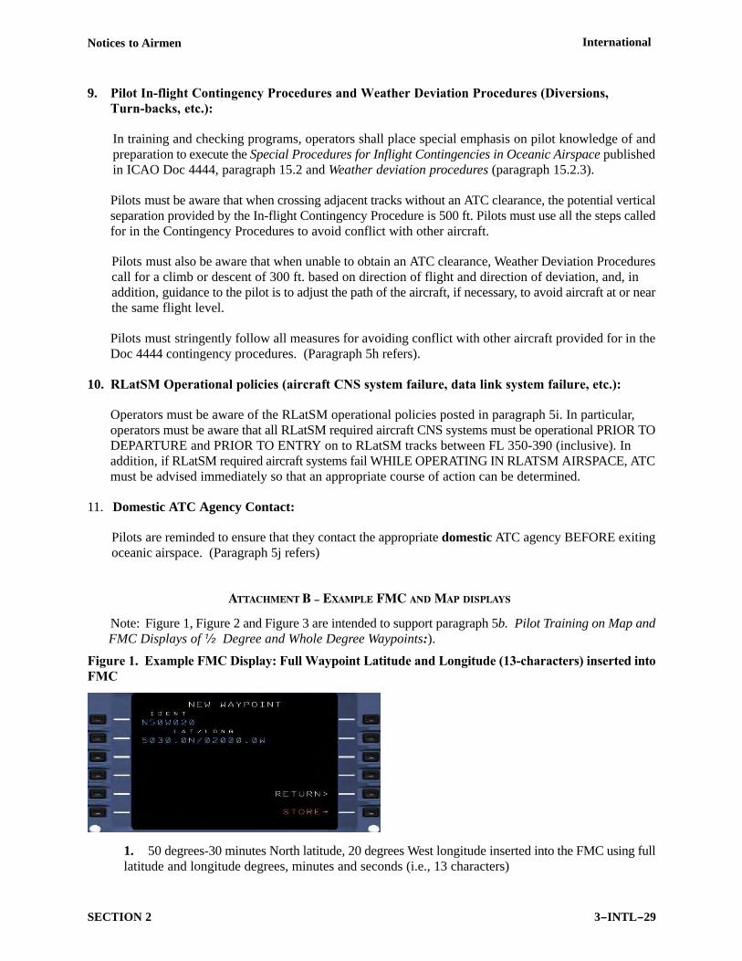
ATTACHMENT B – EXAMPLE FMC AND MAP DISPLAYS
Note: Figure 1, Figure 2 and Figure 3 are intended to support paragraph 5b. Pilot Training on Map and FMC Displays of ½ Degree and Whole Degree Waypoints:).
Figure 1. Example FMC Display: Full Waypoint Latitude and Longitude (13characters) inserted into
FMC
1. 50 degrees-30 minutes North latitude, 20 degrees West longitude inserted into the FMC using fulllatitude and longitude degrees, minutes and seconds (i.e., 13 characters)
International Notices to Airmen
3−INTL−30 SECTION 2
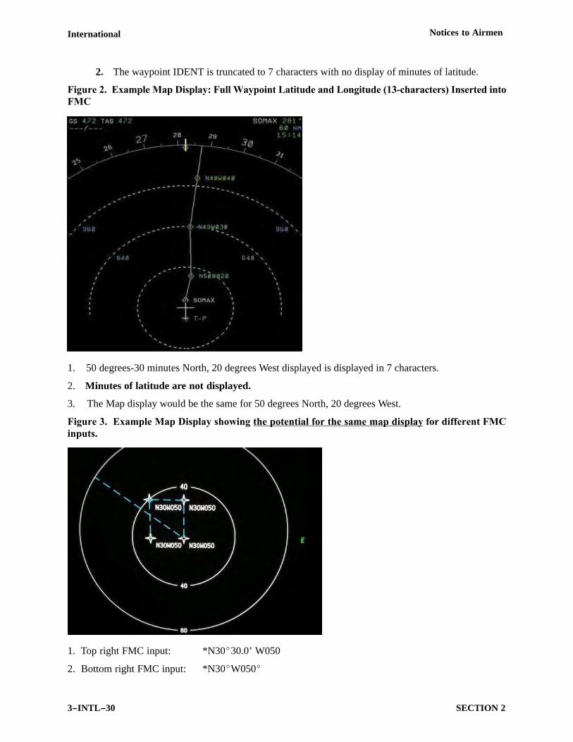
2. The waypoint IDENT is truncated to 7 characters with no display of minutes of latitude.
Figure 2. Example Map Display: Full Waypoint Latitude and Longitude (13characters) Inserted into
FMC
1. 50 degrees-30 minutes North, 20 degrees West displayed is displayed in 7 characters.
2. Minutes of latitude are not displayed.
3. The Map display would be the same for 50 degrees North, 20 degrees West.
Figure 3. Example Map Display showing the potential for the same map display for different FMC
inputs.
1. Top right FMC input: *N30�30.0’ W050
2. Bottom right FMC input: *N30�W050�
Notices to Airmen International
3−INTL−31SECTION 2
*Note related to 1 and 2 above. Significant NAT RLatSM waypoints are planned with whole and halfdegrees of latitude and whole degrees of longitude. The two asterisked inputs are examples of waypointsthat will be used in RLatSM operations. For a large number of aircraft FMS navigation displays, thewaypoint input will result in the identical 7-character waypoint map display.
3. Top left FMC input: N30�30.0’ W050�30.0’
4. Bottom left FMC input: N30�W050�30.0’
#Note related to 3 and 4 above. The half-degree of longitude waypoints above are not used in NAToperations for the RLatSM Trial
(Performance Based Flight Systems Branch, AFS-470, 5/28/15)
18 OCTOBER UPDATE − NORTH ATLANTIC FANS 1/A DATA LINK MANDATE
1. Objective of Notice. The objective of this Notice is to inform United States (U.S.) operators that Phase1 of the North Atlantic Data Link Mandate (NAT DLM) plan will be implemented on
7 February 2013 and to advise them of the related program plans and requirements. (For the purpose of thisNotice, U.S. operators are operators conducting operations under Title 14 of the U.S. Code of FederalRegulations (14 CFR), part 91, part 91 subpart K and parts 121, 125, 125M, or 135).
2. Background. On 4 January 2012, the ICAO Council approved a Proposal for Amendment (PFA) of NATRegional Supplementary Procedures (Regional SUPPS) to mandate, in phases, aircraft equipage with andoperation of FANS 1/A (or equivalent) CPDLC (Controller-Pilot Data Link Communication) and ADS-C(Automatic Dependent Surveillance-Contract) systems. Paragraphs 3.3.1 and 5.4.1 of the approvedamendment to the NAT Regional SUPPS now call for aircraft intending to conduct operations in specifiedNAT airspace to be fitted with and operating FANS 1/A (or equivalent) CPDLC and ADS-C:
a. from 7 Feb 2013, on specified tracks and flight levels within the NAT organized track system (OTS);and
b. from 5 Feb 2015, in specified portions of NAT minimum navigation performance specifications (NATMNPS) airspace.
It is the objective of the NAT DLM plan to enhance communications and surveillance capabilities in NAToperations and thereby, enhance operational safety in the NAT by increasing the number and percentage ofNAT flights conducted by aircraft using FANS 1/A (or equivalent) CPDLC and ADS-C.
Note: Qualification For Exemption To European ATN/VHF Data Link Requirements. See paragraph9 concerning qualification for an exemption to European Aeronautical Telecommunications Network(ATN)/VHF data link requirements for aircraft equipped with FANS 1/A systems prior to 1 January 2014.
3. NAT DLM Implementation Plan – Phase 1 (7 February 2013).
a. The ICAO NAT SPG (North Atlantic System Planning Group) has agreed that for the 7 February 2013phase of the DLM implementation plan, carriage and operation of FANS 1/A (or equivalent) data linksystems will be mandatory:
(1) Between flight levels 360-390 (inclusive) on no more than two NAT Organized Track System (OTS) tracks that are identified in the Remarks section of the NAT OTS message. (See exampleOTS message below).