Embed Size (px)
Citation preview
Guidance on Surveys for Submerged Aquatic Vegetation Compensatory Mitigation Projects
Office of Resilience and Coastal Protection Florida Department of Environmental Protection
Dec. 8, 2020
Contents
1.0 Introduction .....................................................................................................................................4
1.1 Purpose of Monitoring Guidance ..................................................................................................4
1.2 Regulatory Basis for Monitoring ...................................................................................................4
1.3 Submerged Aquatic Vegetation ....................................................................................................5
2.0 Survey Protocols..............................................................................................................................6
2.1 Timing of Surveys.........................................................................................................................6
2.2 Surveys for Planning and Permitting ............................................................................................6
2.2.1 Desktop Assessment of Available Information .....................................................................7
2.2.2 Mapping and Characterization Survey ...................................................................................7
2.2.3 Mapping and Characterization Survey by Site ....................................................................10
2.3 Permit-Required Mitigation Monitoring Protocols .....................................................................12
2.3.1 Assessment of Planting Units ..............................................................................................13
2.3.2 Visual Assessment of Site Conditions .................................................................................14
2.3.3 Line Intercept Surveys .........................................................................................................15
2.3.4 Quantitative Survey of Cover-abundance ............................................................................16
2.3.5 Other Survey Types .............................................................................................................18
2.4 Specifications for Mitigation Monitoring by Site .......................................................................20
2.4.1 Mitigation Site Monitoring Methodology ............................................................................20
2.4.2 Reference Site Monitoring Methodology ............................................................................20
2.4.3 Donor Site Monitoring Methodology ..................................................................................21
3.0 Quality Control/Quality Assurance.............................................................................................21
3.1 Qualifications for Biologists .......................................................................................................21
3.2 In-situ Calibration .......................................................................................................................22
3.3 Data Management .......................................................................................................................22
3.4 Amendment of Survey Protocols ................................................................................................22
3.5 Addressing Potential Conflicts of Interest ..................................................................................23
2
4.0 Success Criteria .............................................................................................................................23
4.1 Success Criteria for Mitigation Site ............................................................................................23
4.2 Success Criteria for Donor Site Recovery...................................................................................24
4.3 Success Criteria for Reducing Vessel Damage ...........................................................................24
5.0 Notification and Reporting...........................................................................................................25
5.1 Notification of Initiation/Completion of Work ...........................................................................25
5.2 Submittal of Data ........................................................................................................................25
5.3 As-built Report ............................................................................................................................26
5.4 Planting Unit Assessment Report ................................................................................................26
5.5 Annual Reports ............................................................................................................................26
5.5.1 Results of the Visual Assessment of Site Conditions (Section 2.3.2) .................................26
5.5.2 Results for Line Intercept Survey (Section 2.3.3) ................................................................27
5.5.3 Results for Cover-abundance Survey (Section 2.3.4) ..........................................................27
5.5.4 Evaluation of Success Criteria (Section 4) ..........................................................................27
5.6 Other Survey Reports ..................................................................................................................27
5.6.1 Reporting for Assessments of Structures .............................................................................27
5.6.2 Reporting for Vessel Damage Assessments ........................................................................28
5.7 Contingency Mitigation Plan ......................................................................................................28
6.0 LITERATURE CITED ................................................................................................................30
3
1.0 Introduction
1.1 Purpose of Monitoring Guidance
The purpose of this document is to provide guidance on Florida Department of Environmental
Protection-approved monitoring protocols for compensatory mitigation projects to offset unavoidable
impacts to submerged aquatic vegetation (SAV) that can be used to make the permitting process more
efficient, predictable and consistent. Aspects of this document are intended to be scalable and adaptable
to work for a wide range of projects state-wide. This document is intended to assist those applying for
permits issued by the Beaches Inlets and Ports Program (BIPP) in Tallahassee, including Joint Coastal
Permits (JCP) and Environmental Resource Permits (ERP). The Submerged Lands and Environmental
Resource Coordination program has reviewed this guidance and determined that it is generally
applicable to ERPs issued by district offices, water management districts and other delegated local
governments. However, each project is unique and coordination with the department (including BIPP
staff, district office staff and aquatic preserve staff, depending upon the project location) is strongly
encouraged during the planning phase before an applicant’s decision to use this guidance document.
This document is not currently adopted by rule or statute. Requirements (e.g., protocols, timelines and
deliverables) described herein will only become binding on applicants/permittees who choose to accept
them as a means of fulfilling regulatory requirements, as monitoring requirements that will be included
as specific conditions of permits. Means and methods other than those described herein may be proposed
by the applicant and will be subject to review and acceptance by the department under applicable rules
and statutes.
1.2 Regulatory Basis for Monitoring
Submerged aquatic vegetation is an economically and ecologically valuable natural resource. In fact,
seagrasses are deemed essential to Florida’s oceans, gulfs, estuaries and shorelines, according to Section
253.04(3)(a), Florida Statutes (F.S.). Therefore, these resources are managed and regulated by the state,
including DEP (FWC 2003). The department requires reasonable assurance that permitted activities will
not adversely affect the habitat of fish, wildlife and listed species, including SAV habitats, pursuant to
Section 373.414(1)(a)2, F.S., Section 62-330.301(1)(d) and subparagraph 62-330.302(1)(a)2, Florida
Administrative Code (F.A.C.), and Section 10.2.2(a) of the ERP Applicant’s Handbook Volume 1.
4
If impacts to SAV are unavoidable, then mitigation shall be required to ensure no net loss of functions,
pursuant to Section 373.414(1)(b), F.S., paragraph 18-21(2)(i), F.A.C., and Section 10.3.1 of the ERP
Applicant’s Handbook Volume 1.
If compensatory mitigation is required to offset impacts to SAV, then surveys are required to provide
information necessary to implement the Uniform Mitigation Assessment Method (UMAM), Rule 62-345
F.A.C., which describes how the department calculates the amount of compensatory mitigation needed
to offset impacts to surface waters, including SAV habitats (pursuant to Section 373.414(18), F.S.).
Note: information on the current condition of SAV resources that will be impacted by the proposed
project is also required for UMAM and a separate guidance document has been developed to assist
applicants with such surveys (DEP 2020). Monitoring is also required to document the success of
mitigation activities (pursuant to Section 10.3.4 of the ERP Applicant’s Handbook Volume 1).
Mitigation monitoring parameters, methods, schedule and reporting requirements, such as those
described herein, will be included as specific conditions of permits in accordance with Section 10.3.4 of
the ERP Applicant’s Handbook Volume 1, subsection 62-4.070(3), F.A.C., and Section 373.413(1), F.S.
The department has the authority to issue any permit with specific conditions necessary to provide
reasonable assurance department rules can be met, pursuant to subsection 62-4.070(3) F.A.C.
1.3 Submerged Aquatic Vegetation
For the purpose of this document, “submerged aquatic vegetation” is defined as a benthic community
comprised of any species of seagrass and/or rhizophytic macroalgae, including both calcareous and non-
calcareous taxa. An analogous definition is used by the National Marine Fisheries Service to describe
SAV, which is designated as an essential fish habitat (NMFS 1998). Drifting macroalgal mats (drift
algae) comprised of filamentous taxa that are ephemeral depositions on the benthos provide ecological
functions (Arroyo and Bonsdorff 2016); however, areas without any seagrass or rhizophytic macroalgae
that contain only drift algae are not considered SAV for the purpose of this document.
The distribution of SAV is not static. Seagrass patches migrate and unvegetated areas between patches
are important to the management and conservation of these resources (Fonseca et al. 1998).
Accordingly, this document defines “SAV habitat” as areas currently vegetated by SAV as well as
currently unvegetated areas adjacent to SAV that have historically supported SAV and are capable of
5
supporting SAV based on current conditions such as the water environment, sediment characteristics and
light availability.
Please be advised, while this document is primarily intended to provide guidance for projects with
marine and estuarine SAV, at the department’s discretion, this guidance may also be applied to/adapted
for use on projects with freshwater SAV resources (e.g., Vallisneria american).
2.0 Survey Protocols
2.1 Timing of Surveys
Surveys should be completed during the peak growing season to capture the maximum spatial extent and
cover of SAV. This is particularly important in portions of the state where seagrasses senesce over the
winter. To be consistent with federal requirements, the department recommends surveys be completed
between June 1 and Sept. 30. However, in some circumstances the department may allow surveys to be
completed at other times during the growing season. For example, under some circumstances, the
department may accept SAV surveys from April to October in most of the state and year-round surveys
may be acceptable in Monroe County and southern Dade County.
2.2 Surveys for Planning and Permitting
The purpose of this section is to describe the types of surveys that are needed to provide the information
necessary to develop a mitigation plan. Every project is unique; therefore, applicants are strongly
encouraged to coordinate with the department before initiating field work to identify appropriate
methods and to schedule joint site inspections. Early coordination is especially important if an
application will be submitted outside of the growing season; it is imperative department staff have an
opportunity to verify site conditions during the growing season.
Generally, the department will request a desktop assessment of available information and a mapping and
characterization survey (MC), which includes the delineation of site boundaries and existing resources
as well as an in-situ visual assessment of site conditions. For larger sites, a reconnaissance survey
(RECON) will typically be needed to identify resources. Proposed mitigation site(s) should be surveyed
during the growing season before the development of a project-specific mitigation plan. At this time,
reference site(s) and donor sites for transplantation activities (if necessary) should also be identified and
surveyed. 6
Once these tasks have been completed, applicants should provide a detailed description of the methods
used to evaluate potential sites and the results of all desktop and in-situ survey efforts with the
mitigation plan. Generally, mitigation plans are drafted during the planning/pre-application phase of
project development and completed in consultation with the department during the permitting process.
Mitigation plans shall be detailed and shall contain all information required pursuant to Section 10.3.3 of
the ERP Applicant’s Handbook Volume 1.
2.2.1 Desktop Assessment of Available Information
Prior to the initiation of field work, a desktop assessment (DA) should be completed. All available
information on resources in the proposed mitigation area shall be compiled and reviewed. For example,
information on SAV in the project area may include historical aerial photography, imagery from
unmanned aerial vehicles, side-scan survey data and data from previous field surveys. This information
should be used to guide site selection and narrow down the number of potential sites that will be
surveyed. A summary of the information used in the site selection process should be included as an
appendix to the mitigation plan.
Any relevant information that is available on physical attributes of the proposed sites should also be
compiled and reviewed. Understanding environmental conditions – such as water depth, tidal height,
current speed, wave exposure and fetch and flushing – can be useful for evaluating the current and with-
project conditions at the mitigation site. Therefore, information on these parameters should be evaluated
if available. Existing sources of data such as bathymetric surveys, geotechnical investigations and water
quality monitoring stations should also be reviewed as part of the desktop assessment.
2.2.2 Mapping and Characterization Survey
This section describes the methods that should be used to investigate potential sites to inform the
planning and permitting process. Mapping and characterization of site conditions are essential tasks. The
manner in which these methods are employed at the mitigation, reference and donor sites is described
below in section 2.2.3.
7
2.2.2.1 Mapping
Once potential mitigation site(s), reference site(s) and/or donor site(s) have been identified, the
boundaries of each of these sites should be field recorded as accurately as possible. An in-situ survey
should also be completed to identify the locations of any naturally occurring SAV within and/or adjacent
to each of these sites, as described below in sections 2.2.3.1, 2.2.3.2 and 2.2.3.3. The position of SAV
resources shall be recorded as accurately as possible. For sites less than 0.25 acres, the distance between
survey track lines shall be no greater than the visibility at the site at the time of the survey, such that the
entire benthos is visually assessed for the presence of SAV and a map of SAV with a 1-meter resolution
shall be produced. During this survey, the spatial distribution of SAV within the survey area(s) shall be
mapped. The edge of each SAV patch shall be visually assessed by divers in-situ and divers shall record
the position of the edge as accurately as possible. The total acreage of SAV within each patch/bed shall
be reported. For projects where SAV is extensive and continuous, it may be sufficient to delineate only
the SAV edge that is proximate to the proposed activity (e.g., adjacent to a relict dredged hole to be
restored).
For sites greater than 0.25 acres, a RECON shall be conducted to identify currently vegetated areas. The
RECON may be completed using towed video, only if video is watched in real-time by observers on the
vessel to ensure the camera is positioned at the appropriate angle and video is of sufficient quality to
identify resources. Alternatively, towed diver surveys may be completed by biologists using self-
contained underwater breathing apparatus (SCUBA). In-water surveys are preferred to video surveys in
areas where water clarity is low or where resources are sparse or small in stature (and therefore unlikely
to be detected on video); in these cases, biologists should traverse the area and visually assess resource
boundaries. Spacing between survey tracks should be minimized to the maximum extent practicable to
thoroughly survey the benthos (e.g., transects spaced at 10-meter intervals). The coordinates of the
survey track lines shall be reported along with the in-water visibility (width of each visually censused
area) on the date(s) of the survey.
The information obtained from this mapping effort shall be used to produce a georeferenced map
showing the distribution of SAV taxa in the project area, which should be included in the permit
application. To ensure map products will be useful for planning and permitting, it is recommended the
following mapping criteria be used for creating and submitting SAV map-related deliverables:
8
All spatial information should be collected using a sub-meter accurate Differential Global
Positioning System (DGPS) unit.
Geographical information should be provided in the State Plane Coordinate System (SPCS) for
Florida (NAD83) and coordinates (latitude and longitude) should be provided in decimal degrees
to the fifth decimal place (hundred-thousandths).
An ArcGIS map package (“.mpk” file format) or similarly detailed and complete data package
(e.g., CAD “.dwg” file format) should be provided with spatial data and metadata.
SAV areas with different species compositions and/or densities should be distinguished via
symbology (e.g., coloration and fill patterns).
Map figures should include a legend, metric scale bar and north arrow for reference.
Map figures should be shown at an appropriate scale that allow features to be readily discerned
on a standard-size printed page.
Map figures should be overlaid on recent aerial imagery and should include polygons or lines
depicting project boundaries and significant features.
2.2.2.2 Characterization of Site Conditions
For planning and permitting purposes, an in-situ visual assessment of site conditions shall be completed
concurrent with the mapping efforts (Section 2.2.2.1) to characterize the current condition of the
mitigation site, the reference site and the donor site (if such as a site is necessary). This characterization
of site conditions should document the following indicators of function: location and landscape support,
water environment and community structure (as defined in 62-345.500, F.A.C.). Site conditions such as
sediment type, sediment depth, salinity, water temperature, current speed and flushing should be noted.
For all projects, water depth shall be measured, corrected for tidal height and reported in metric units.
For some projects (e.g., restoration of a relict dredged hole), a detailed bathymetric survey of the site
may be required. Apparent water quality issues such as harmful algal blooms and signs of eutrophic
conditions, such as mats of cyanobacteria, should also be reported. Landscape features, such as other
natural communities, shoals and man-made structures, within and adjacent to sites should be described.
The proximity of the site to any channels should be noted as well as boat traffic and recreational use in
and around the site. Anthropogenic impacts such as the presence of debris, propeller scars or vessel
blowouts within and adjacent to sites should be described. Wildlife observed at the site and signs of
wildlife, including evidence of bioturbation, should also be reported. A map of all surveyed sites and a
9
description of conditions at each site should be provided in the permit application and in the mitigation
plan.
Community structure should be qualitatively assessed; the general condition of vegetation such as
canopy height, flowering, epiphyte coverage and disease shall be described. SAV communities shall also
be quantitatively evaluated within quadrats placed within SAV patches. Randomized placement of
quadrats is preferred, but quadrats can be placed haphazardly, if randomization is not practicable.
Quadrat placement shall not be biased. However, only vegetated areas shall be surveyed. Quadrats
placed within bare areas within the SAV habitat should be noted and repositioned into areas containing
SAV. Within each quadrat the cover-abundance (CA) of SAV shall be assessed as prescribed in Section
2.3.4. Replicate quadrat samples are necessary to adequately characterize the SAV community. It is
recommended that a 1 m2 (1 m x 1 m) quadrat be used for this survey; if a smaller quadrat is used, then
additional quadrats should be sampled. At least 5 m2 should be sampled in small areas (those less than
0.1 acres). For larger sites, it is generally recommended that at least 1 m2 be sampled per 80 m2 of the
area to be surveyed, which is a density of approximately 50 (1 m x 1 m) quadrats per acre. A description
of the community structure, including the species composition and percent cover of SAV based on
quadrat data, shall be provided with the application and in the mitigation plan. Note: the purpose of this
characterization survey is to provide information on site conditions for planning and permitting, more
thorough sampling will typically be required by specific conditions of the permit to document the
success of mitigation activities (Section 2.3); data collected during the mapping and characterization
survey will not be used to evaluate changes in the condition of sites over time.
2.2.3 Mapping and Characterization Survey by Site
This section describes how the methods for mapping and characterization surveys described above
(Sections 2.2.2.1 and 2.2.2.2, respectively) should be employed at the mitigation (2.2.3.1), reference
(2.2.3.2) and donor sites (2.2.3.3).
2.2.3.1 Mitigation Site Mapping and Characterization Survey
Once the potential mitigation site(s) has/have been selected, a mapping and characterization survey
should be conducted. Site boundaries should be field recorded as accurately as possible. For creation
projects, the property or project boundaries that will be converted into SAV habitat shall be delineated.
For SAV restoration and enhancement projects, the entire area to be restored or enhanced (i.e., site
10
boundaries) shall be delineated. The boundary of each feature that will be remediated/restored, such as
vessel groundings and blow-outs, shall also be delineated. Propeller scars and other linear features can
generally be defined by measuring the width and reporting the end points; additional points should also
be recorded along linear features, if necessary, to accurately document dimensions (i.e., inflection
points). The depth of propeller scars, grounding sites and blowouts excavated by vessels, shall also be
measured relative to the surrounding undisturbed seafloor.
For any other type of restoration and enhancement projects, the delineation methods should be
coordinated with department staff. Additionally, an in-situ survey should be completed to identify the
locations of any naturally occurring SAV within and/or adjacent to the mitigation site(s) (Section
2.2.2.1). A continuous track-line along the SAV edge is preferred, but if this is not possible, then
individual data points (waypoints/coordinates) may be collected (e.g., at 5-meter intervals or major
inflection points) to document the position of the edge.
Concurrent with the mapping effort (above), a visual assessment of SAV within and adjacent to the
mitigation site shall be completed to characterize current conditions (Section 2.2.2.2). The information
from this survey will be used by the department to determine if the proposed mitigation is appropriate
for offsetting project-related impacts to SAV. If the proposed mitigation is determined to be appropriate,
the results of this survey will also be used by the department (in addition to other available information,
including observations by department staff during on-site inspections) to evaluate the amount (acreage)
of compensatory mitigation required to offset impacts to SAV via UMAM.
2.2.3.2 Reference Site Mapping and Characterization Survey
A mapping and characterization survey of SAV resources near the proposed mitigation sites shall be
conducted to locate and designate specific site(s) that shall serve as a reference for comparison to the
mitigation site. Reference site(s) should be located as close as possible to the mitigation site. Reference
site(s) should be outside of the influence of any mitigation-related construction activities (secondary
impact areas: mixing zones, staging and anchoring areas). An in-situ visual assessment (Section 2.2.2) of
the potential reference site(s) shall be completed to demonstrate that site conditions (e.g., water depth,
sediment type, wave energy) and the SAV community (e.g., species composition and density) are similar
to those that the mitigation site is expected to have at the time of success determination (as described in
the mitigation plan). The reference site boundaries shall be recorded as accurately as possible. The
11
purpose of this survey is to provide a qualitative description of the site(s) and justification for selection
of the site(s) as a reference for assessing the mitigation site(s).
2.2.3.3 Donor Site Mapping and Characterization Survey
Not all mitigation projects will include the use of a donor site for harvesting of seagrass for
transplantation to the mitigation site. For example, a donor site is not necessary if materials are
harvested from direct impact areas that would otherwise be lost, if nursery-grown seagrasses are
available or if natural recruitment is expected to occur relatively rapidly. If harvesting of seagrasses
from a donor site is needed to obtain materials for planting at the mitigation site, then potential donor
sites will need to be identified during the planning and permitting process in coordination with the
department (permitting staff as well as aquatic preserve managers, if applicable). Donor sites should be
as close as possible to the proposed mitigation site to reduce stress during transport. Donor sites should
appear healthy and capable of rebounding from disturbance and should be densely covered by pioneer
seagrass species, such as Halodule wrightii and Syringodium filiforme.
Once potentially suitable sites have been identified, a mapping and characterization survey shall be
completed. Specifically, an in-situ visual assessment shall be completed to characterize the current
condition of SAV resources at the site and to provide reasonable assurance that harvesting of materials
will not adversely affect these areas. These observations shall be used to select suitable area(s) from
which to harvest seagrass. The boundaries of all donor sites should be recorded as accurately as possible.
The size of the donor site will be determined based on the amount of seagrass materials needed to
vegetate the mitigation site. The results of this survey shall be used to develop a plan for harvesting
material, which should be detailed in the mitigation plan. A georeferenced map of the donor site(s)
boundaries and the starting and ending positions (GPS coordinates) of all proposed transects along
which materials will be harvested should be included in the mitigation plan.
2.3 Permit-Required Mitigation Monitoring Protocols
This portion of the document (Sections 2.3, 3, 4 and 5) is intended to provide guidance and to serve as a
template for monitoring of permitted SAV mitigation projects. The department recommends the
methods described herein be used to document the status of mitigation sites and to determine whether
they have achieved permit-required success criteria (Section 4.0). As previously stated (Section 1.1), the
requirements (e.g., protocols, timelines, deliverables) described herein are only binding on permittees
12
that accept them as a means of fulfilling regulatory requirements.
Permits requiring compensatory mitigation to offset unavoidable impacts to SAV will include specific
conditions prescribing the monitoring methods to be used to document the success of mitigation
activities. Generally, a specific condition is used to incorporate a final department-approved mitigation
plan as an enforceable component of the permit. Mitigation monitoring parameters, methods, schedule
and reporting requirements (such as those described herein) will be included in this plan, pursuant to
Section 10.3.4 of the ERP Applicant’s Handbook Volume 1. For some projects, bathymetric surveys
may also be required to document site conditions before and after mitigation. The need for such surveys
should be coordinated with the department during the planning and permitting process, as the mitigation
project is being developed, before finalizing the mitigation monitoring plan.
Multiple monitoring events are needed to document the status and success of permitted mitigation
activities, beginning with baseline surveys of the reference site(s) and donor site(s) during the same
growing season that mitigation activities (e.g., filling, harvesting and planting) are completed. An as-
built survey should be conducted at the mitigation site immediately following the completion of
mitigation activities (e.g., construction and/or planting). Additionally, if the mitigation site is planted, a
survey will typically be completed 1-month after planting is completed to assess the condition of
planting units (PUs). Annual surveys will be completed at the mitigation, reference and donor sites until
permit-required success criteria have been achieved (Section 4). All surveys should be conducted during
the growing season (Section 2.1), with an effort made to complete each survey in the same month each
year for comparability of results. Monitoring of the mitigation site and corresponding reference site is
typically conducted annually for at least five years. Donor site(s) are typically monitored annually for
three years or until recovery of the sites is achieved. The number and timing of monitoring events for
mitigation projects should be determined in coordination with the department during the
planning/permitting process.
2.3.1 Assessment of Planting Units
If the mitigation site is planted, then an assessment of planting units (APU) should be conducted
approximately one month (but no later than 45 days) after the completion of planting to document the
survival and expansion of planting units (PUs). The purpose of this survey will be to inform adaptive
management and to identify whether additional planting is necessary. If additional PUs are transplanted
13
in the mitigation site because of low PU survival following the initial planting event, then another APU
should be completed 1-month after the completion of the second planting event. If additional planting is
necessary, the permittee should coordinate with department staff regarding appropriate adaptive
management measures to improve planting success (e.g., species and/or spacing of PUs) and to reduce
potential impacts from repeatedly harvesting at donor sites (e.g., use of nursery-grown PUs). If PUs
have not yet coalesced (are still able to be distinguished from one another) during the year 1 annual
survey, then another APU should also be completed during this survey.
A sampling scheme for the APU should be developed during permitting and included in the mitigation
plan. All PUs should be surveyed if less than 500 PUs were transplanted to the mitigation site. For larger
projects, at least 10 replicate transects (i.e., rows along which PUs were installed) should be surveyed
(Fonseca et al. 1998). For the purpose of this survey, the presence of one or more shoot(s) indicates
survival of a PU (Fonseca et al. 1998). The presence or absence of each PU will be reported and the
percentage of surviving PUs will be calculated. The areal extent of each PU will be determined by
measuring its dimensions (longest apparent axis and perpendicular to that axis); if PU has only a few (3
or less) shoots, then a de minimus value (0.0025 m2) will be recorded. The area of PUs will be summed
to calculate the acreage of seagrass at the site.
2.3.2 Visual Assessment of Site Conditions
Site conditions should be visually assessed (VA) during each survey and indicators of function such as
canopy height, epiphyte coverage, flowering, disease, drift algae, bioturbation, propeller scars, shoaling,
water clarity and visibility shall be observed and noted. Any signs of water quality degradation or
eutrophication shall be noted. Any signs or indicators of mechanical damage (anthropogenic or storm-
related impacts), such as sloughing, scouring, exposed rhizomes, burial or sediment accumulation should
be noted. Density of seagrasses shall be observed and reported as either sparse (<5% cover), moderate
(25-50% cover) or dense (50-100% cover); if density varies within the site(s), this should be described
in the reports. A detailed description of the current conditions shall be provided, including a description
of any visually conspicuous changes in the condition of resources compared to previous surveys.
Representative photographs of each patch (or discrete area) shall be taken to document site conditions.
Additionally, water depth shall be measured, corrected for tidal height and reported in metric units.
14
2.3.3 Line Intercept Surveys
Line intercept (LI) surveys will typically be completed at all sites during annual surveys and at the
reference and donor sites during the baseline survey (Table 2) to: 1) measure the expansion/coalescence
of seagrass at the mitigation site, 2) provide an analogous dataset for the reference site(s) for comparison
to the mitigation site and 3) document seagrass recovery at the donor site(s). Note: under some
circumstances (e.g., if no donor site is used), a comprehensive sampling scheme using numerous
randomly placed quadrats to survey SAV may be used in-lieu of line intercept surveys. If line intercept
surveys are included in the monitoring plan, a series of transects shall be established at the donor,
mitigation and reference sites. For the mitigation and donor sites, monitoring transects will include a
representative subset of rows along which seagrass was planted and harvested, respectively.
The layout of transects (number, location, orientation and length) for each of the sites should be
determined in coordination with the department during permitting and will be specified in the mitigation
plan. A minimum of 10 transects at each site is typically recommended; the number of transects to be
sampled at each site should be coordinated with the department during the planning and permitting
process. The nature of the project should be considered when determining appropriate transect
placement. For example, transects may be placed randomly or spaced regularly throughout SAV
creation sites. For mitigation sites where vessel damage (e.g., propeller scars or blowouts) will be
remediated by filling and/or planting, transects should be positioned within those features that were
restored. To ensure consistency between monitoring events, the starting and ending positions of each
transect shall be marked via the installation of PVC pipe, sub-surface buoy or other means and the
starting and ending positions of each transect shall be recorded as accurately as possible. Markers used
to identify transects shall be removed following the completion of the last monitoring event at each site.
All transects shall be surveyed to document the linear extent (recorded to the nearest 0.1 m) of SAV
present along (directly below) each transect line. During each line intercept survey, a biologist shall
swim the length of each transect and note the location and linear extent along the transect tape of bare
substrate, rhizophytic macroalgae and seagrass (reported by species). During this survey, drift algae
should be noted in the field observations as sparse, moderate or dense and then carefully removed to
ensure no SAV is present underneath. Areas containing only drift algae shall be considered as bare
substrate for the purposes of assessing net-cover/coalescence of SAV. For segments along the transect
where SAV taxa overlap, each shall be reported.
15
The total length of each transect shall be reported along with the percentage of transect covered by each
category of cover, which are defined as follows: 1) species of seagrass planted at the mitigation site, 2)
seagrass species that were not planted at the mitigation site, 3) rhizophytic macroalgae and 4) bare
substrate, including areas with only drift algae. The LI data shall be used to calculate the net-acreage of
SAV coverage at each of the sites; net-acreage of SAV = (total acres of site) X (percentage of site
covered by SAV). Reports shall include calculations for: 1) net-acreage of the seagrass species planted
at the mitigation site 2) net-acreage of any seagrass taxa (including but not limited to those that were
planted at the mitigation site) and 3) net-acreage of any SAV.
2.3.4 Quantitative Survey of Cover-abundance
The cover-abundance (CA) of SAV will be quantified during each Annual Survey at the mitigation and
reference sites and during the Baselines Survey of the reference site(s). The cover-abundance of SAV at
donor sites will not be quantified unless recovery does not occur as expected (within 3 years). The
number (replication) and placement (e.g., random or uniformly distributed) of quadrats surveyed will be
determined in coordination with the department during permitting and shall be specified in the
mitigation plan. For small projects, it may be possible to survey the entire site using a grid of quadrats or
series of belt transects. For larger projects, the applicant should use cover data collected during the
mapping and characterization surveys (Section 2.2.2) to evaluate natural spatial variability in SAV cover
at the site(s) and use this information to determine the minimum number of quadrats necessary to
evaluate success criteria (Section 4.0): for example, conduct a power analysis to determine sample size
based on the minimal detectable difference. During the initial monitoring event, quadrat placement may
need to be adjusted so all quadrats are positioned in SAV. Once established, the positions of quadrats
shall be consistent between monitoring events; quadrat positions will be recorded with respect to their
positions along transects or will be recorded using a sub-meter DGPS.
The cover-abundance of SAV shall be visually assessed within 1 m2 (1 m x 1 m) quadrats. The
department shall be consulted regarding the possible use of smaller sized quadrats (0.25 m2 or 0.5 m2);
the use of smaller quadrats will typically require additional quadrats to be sampled. Generally, it is
recommended quantitative data be collected within a quadrat that is divided into 100 sub-units or
“cells”. Cover-abundance (percent cover) of SAV is determined by counting the number of cells with
SAV and calculating the percentage of cells within the quadrat with SAV. This method is preferred
because it is highly repeatable and interobserver error is typically low. However, the use of subdivided
16
quadrats (cell count method) may not be practicable at sites where long-bladed seagrass taxa are dense.
Under certain circumstances, depending upon project-specific logistical constraints and site conditions,
the department may accept rapid estimates of SAV cover. For example, the percent cover of SAV may
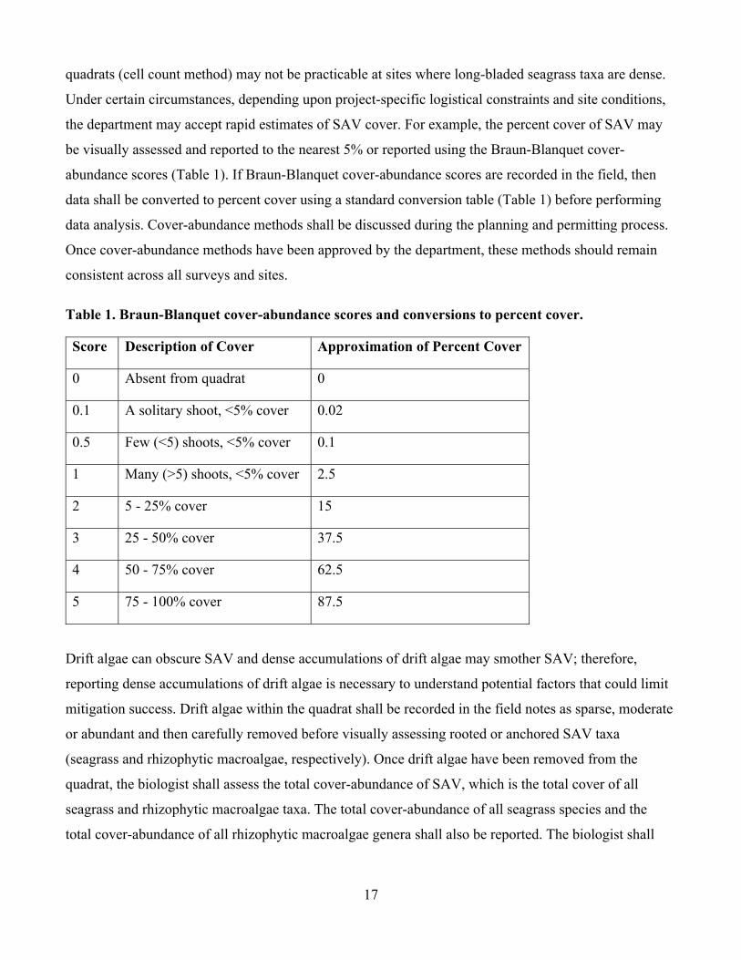
be visually assessed and reported to the nearest 5% or reported using the Braun-Blanquet cover-
abundance scores (Table 1). If Braun-Blanquet cover-abundance scores are recorded in the field, then
data shall be converted to percent cover using a standard conversion table (Table 1) before performing
data analysis. Cover-abundance methods shall be discussed during the planning and permitting process.
Once cover-abundance methods have been approved by the department, these methods should remain
consistent across all surveys and sites.
Table 1. Braun-Blanquet cover-abundance scores and conversions to percent cover.
Score Description of Cover Approximation of Percent Cover
0 Absent from quadrat 0
0.1 A solitary shoot, <5% cover 0.02
0.5 Few (<5) shoots, <5% cover 0.1
1 Many (>5) shoots, <5% cover 2.5
2 5 - 25% cover 15
3 25 - 50% cover 37.5
4 50 - 75% cover 62.5
5 75 - 100% cover 87.5
Drift algae can obscure SAV and dense accumulations of drift algae may smother SAV; therefore,
reporting dense accumulations of drift algae is necessary to understand potential factors that could limit
mitigation success. Drift algae within the quadrat shall be recorded in the field notes as sparse, moderate
or abundant and then carefully removed before visually assessing rooted or anchored SAV taxa
(seagrass and rhizophytic macroalgae, respectively). Once drift algae have been removed from the
quadrat, the biologist shall assess the total cover-abundance of SAV, which is the total cover of all
seagrass and rhizophytic macroalgae taxa. The total cover-abundance of all seagrass species and the
total cover-abundance of all rhizophytic macroalgae genera shall also be reported. The biologist shall
17
also report the cover-abundance of each seagrass species and each rhizophytic macroalgae genera
present within the quadrat.
The results of this assessment should be used to calculate the frequency of occurrence (percentage of all
quadrats that contained SAV), the density (average cover-abundance for all quadrats sampled) and the
abundance (average cover-abundance for only those quadrats containing SAV). These metrics shall be
calculated for 1) all SAV, 2) all seagrass, 3) all rhizophytic macroalgae, 4) each seagrass species and 5)
each rhizophytic macroalgae genera.
For some projects, the density of seagrass shoots shall also be recorded and reported as another metric of
abundance. Seagrass shoots shall be counted within multiple 0.01 m2 (10 cm x 10 cm) quadrats and the
density of seagrass shoots shall be reported separately for all species present within quadrats. The
collection of seagrass shoot density data is consistent with recommendations from the Deepwater
Horizon Natural Resource Damage Assessment Trustees (2016) and the Gulf of Mexico Habitat
Resources Team (Handley et al. 2018).
2.3.5 Other Survey Types
2.3.5.1 Assessment of Structures
Structures, such as signs, buoys and bird stakes, are sometimes emplaced at SAV mitigation sites. For
example, at mitigation sites where damage caused by vessels is restored by filling and/or planting, the
permittee may be required to install informational signage to notify vessel operators of the presence of
shallow SAV at the mitigation site. In some phosphorous-limited sites with H. wrightti, bird stakes may
be temporarily installed to facilitate the growth of SAV. If structures are not properly maintained, then
SAV resources may be adversely affected; derelict structures may smother SAV and will not serve their
intended purpose of protecting SAV from vessel damage. Therefore, Assessments of Structures (AS)
shall be completed to document the status (presence/absence) and structural integrity of any signage,
buoys, stakes and any other structures that are emplaced at the mitigation site. All structures emplaced at
mitigation sites shall be visually assessed during each Annual Survey; an additional assessment shall be
completed following any major storm event that may have damaged or dislodged structures.
Representative photographs should be taken to document the condition of structures and any visually
conspicuous signs of damage due to derelict or dislodged structures should be documented. Note:
permits will typically include specific conditions describing the installation, maintenance and removal of
18
such structures; these conditions should be coordinated with the department during the planning and
permitting process.
2.3.5.2 Vessel Damage Assessment
Some mitigation projects include the installation of informational signs at/around a mitigation site to
notify boaters of SAV resources to protect these resources from vessel damage. If such signage is
emplaced as part of a mitigation project, then vessel damage assessments (VDA) may also be completed
to document recovery of the area encompassed by the signage. During the growing season before the
installation of in-water signs, the number, area (acreage) and severity (depth: 0 – 10 cm, 11 – 20 cm, >
20 cm) of damaged areas (e.g., propeller scars or blowouts) shall be visually assessed and documented
to establish the pre-project baseline condition. The pre-project baseline condition will also be evaluated
by assessing available aerial imagery over a period of at least five years before the installation of the
signage. During the first five years after sign installation, the number, area and severity of damaged
areas shall also be visually assessed in the field annually and aerial images of the mitigation site shall be
analyzed on an annual basis to evaluate changes in the number and area of vessel-damaged areas at the
site over time. If the aerial images are available before the field effort, then these images shall be used to
guide the field survey; all vessel-damaged areas visible on the aerials shall be inspected in the field.
During each field survey, the boundaries of all vessel-damaged areas shall be delineated as accurately as
possible; these data will be used to calculate the acreage of damaged areas. The acreage of propeller
scars and other linear features will be measured by recording the width and end points; additional points
should also be recorded, if necessary, to accurately document dimensions. The results of these surveys
should be used to create a geo-referenced map that illustrates changes in vessel damage over time (e.g.,
features color-coded by year); mapping criteria described in (Section 2.2.2.1) should be used for this
purpose.
2.3.5.3 Surveys to document potential unauthorized impacts
Depending upon the nature of the project and site conditions, the department may require surveys to be
conducted before and after construction at the mitigation site(s) to document potential impacts to
adjacent SAV resources in order to ensure compliance with Section 373.414(1)(a)2, F.S. (DEP 2020).
For example, filling a relict dredged hole may temporarily elevate turbidity, which can cause
sedimentation on SAV beds around the perimeter of the hole. Impacts may also occur due to accidents
during construction of the mitigation project, e.g., spillage of materials or dragging of anchors. A
19
separate guidance document has been developed to assist applicants in developing monitoring protocols
to document potential unauthorized impacts to SAV resources (DEP 2020). The applicant should
coordinate with department staff during the planning/permitting process to determine which monitoring
methods are appropriate for their project.
2.4 Specifications for Mitigation Monitoring by Site
This section describes how the survey methods described above (Section 2.3) should be employed at the
mitigation (2.4.1), reference (2.4.2) and donor sites (2.4.3).
2.4.1 Mitigation Site Monitoring Methodology
If the mitigation site will be planted, then immediately following planting, the number and spacing of
PUs transplanted to the mitigation site shall be reported to document planting was completed in
compliance with the mitigation plan (as-built report). One month after each planting event (and again
during the year 1 annual survey if PUs have not yet coalesced), the survival and acreage of PUs shall be
documented (APU) and reported (Planting Report; Section 2.3.1). Annual Surveys shall be conducted
following the completion of construction and planting activities at the mitigation site; these surveys shall
include a visual assessment of site conditions (Section 2.3.2), line intercept surveys along transects
(Section 2.3.3) and the collection of quantitative data on the cover-abundance of SAV in quadrats
(Section 2.3.4). Annual surveys shall be conducted at the same time the reference and donor sites are
surveyed. The mitigation site will be surveyed annually for at least five years. If success has not been
achieved by year 5, but success appears imminent, then annual monitoring shall continue until the
mitigation site achieves success criteria (Section 4.0).
2.4.2 Reference Site Monitoring Methodology
A Baseline Survey shall be conducted and transects shall be established at the reference site during the
same growing season that construction and/or planting of the mitigation site is completed. All transects
shall be marked via the installation of PVC pipe, sub-surface buoy or other means and the starting and
ending positions of each transect shall be recorded as accurately as possible. The Baseline Survey and
subsequent Annual Surveys of the reference site shall consist of a visual assessment of site conditions
(Section 2.3.2), line intercept surveys along transects (Section 2.3.3) and the collection of quantitative
data on the cover-abundance of SAV in quadrats (Section 2.3.4). Annual monitoring shall be conducted
at the same time the mitigation site and donor sites are surveyed. Monitoring of the reference site will be
20
conducted annually for at least five years.
2.4.3 Donor Site Monitoring Methodology
A Baseline Survey shall be conducted and transects shall be established at the donor site during the same
growing season that planting of the mitigation site is completed, immediately before the harvesting of
seagrass. The coordinates for the starting and ending positions of each transect along which donor
materials are harvested shall be marked via the installation of PVC pipe, sub-surface buoy or other
means and the starting and ending positions of each transect shall be recorded as accurately as possible.
Following harvesting, Annual Surveys shall be conducted to document the recovery of seagrasses at the
donor site. The Baseline Survey and each subsequent Annual Survey of the donor site(s) shall consist of
a visual assessment of site conditions (Section 2.3.2), line intercept surveys along transects (Section
2.3.3). Quantitative data on the cover-abundance of SAV (Section 2.3.4) will only be collected if
following the year 3 survey line intercept results indicate bare areas are not recovering as expected (e.g.,
the average linear extent of seagrass declines over time relative to the Baseline Survey). Annual
monitoring shall be conducted at the same time the reference and mitigation sites are surveyed. Donor
sites shall be monitored annually for three years or until recovery of the sites is achieved.
3.0 Quality Control/Quality Assurance
Measures shall be taken to ensure the production of high-quality data, which are accurate, complete and
consistent. Data should only be collected by qualified biologists, who have cross-trained and completed
in-situ calibration exercises to reduce interobserver error. The data management process should be well
documented and transparent. Consistent methods should be used for all monitoring events to allow
temporal comparisons to be made between datasets.
3.1 Qualifications for Biologists
To provide reasonable assurance surveys will accurately document the condition of SAV resources, all
surveys should be conducted by qualified biologists with experience performing in-situ SAV surveys.
The department recommends biologists have at least a Bachelor of Science (a graduate degree is
preferable, but not required) from an accredited institution in either marine biology, biology with a
concentration in marine sciences, environmental science with a minor in biology or a similar degree.
Biologists should also have professional experience and expertise in surveying SAV (preferably for
similar construction projects) and a scientific knowledge of SAV. Biologists should have experience
21
collecting data while snorkeling and certification for self-contained underwater breathing apparatus
(SCUBA) may be required if site conditions necessitate such equipment. The resumes for all biologists
shall be submitted to the department at least 15 days before the initiation of surveys. The department
will review this information, verify whether biologists meet the minimum qualifications and will provide
written comments regarding any perceived deficits in qualifications or experience.
3.2 In-situ Calibration
If more than one biologist is responsible for in-situ data collection, then all biologists shall participate in
cross training and calibration activities to verify correct species identification and survey practices.
These Quality Assurance/Quality Control (QA/QC) activities should be completed at the beginning of
each monitoring event. The results of these QA/QC activities shall reflect consistency of at least 90% for
each SAV cover metric that will be used for the project (e.g., cell-counts, Braun-Blanquet scores and
shoot counts); biologists should be able to positively identify all SAV taxa (i.e., 100% agreement on
seagrass species and macroalgae genera). Copies of the field sheets used for these QA/QC activities
should be submitted with data deliverables (Section 5.2). If only one biologist will be collecting data for
a project, then regular cross-training and calibration with other biologists is recommended but is not
required.
3.3 Data Management
During data collection, biologists shall check their field datasheets to ensure completeness, legibility and
accuracy. Biologists should initial each sheet after it has been checked in this manner. Once field
datasheets are cleaned and dried at the office, data shall be entered into a project-specific Excel
spreadsheet. The spreadsheet data shall be checked against the original datasheet (or a photocopy) to
ensure data were transferred correctly. Any changes to datasheets shall be made in coordination with the
biologist who collected the data; any changes to field sheets shall be done using a colored marker.
Datasheets shall be electronically scanned, saved as pdf files and submitted to the department with data
deliverables (Section 5.2).
3.4 Amendment of Survey Protocols
Consistent data collection methods are necessary to evaluate changes in the condition of SAV resources
over time. If any amendments to the sampling design or methods are necessary due to field conditions or
any other reason, then the permittee and the monitoring firm shall contact resource staff in the
22
permitting office that issued their permit (BIPP, District Office or other delegated permitting authority).
Any changes to permitted monitoring protocols shall be coordinated with department staff and the
permittee or their monitoring firm must receive written approval from the department before the
implementation of revised protocols. Such coordination is necessary to ensure revised protocols fulfil
the monitoring objectives and provide reasonable assurance to the department. Note: a permit
modification may be required to authorize changes to survey protocols.
3.5 Addressing Potential Conflicts of Interest
Permittees who want to remain eligible for potential cost-sharing of monitoring costs for JCP projects
must demonstrate there are no potential conflicts of interest or perceptions of such conflicting interests.
Therefore, monitoring data and statistical analysis must be provided directly and concurrently from the
monitoring firm to the department, permittee, consultant(s) and local sponsor(s) in order to comply with
the Florida Auditor General report 2014-064 and to be consistent with Section 287.057(17)(a)(1), F.S.
4.0 Success Criteria
This section describes how success criteria will be developed for mitigation sites and donor sites and
how these criteria will be evaluated using the monitoring data.
4.1 Success Criteria for Mitigation Site
Mitigation success shall be measured in terms of whether the objectives of mitigation activities are
realized pursuant to Section 10.3.6 of the ERP Applicant’s Handbook Volume 1. An overarching
objective of mitigation is to achieve viable and sustainable ecological and hydrological functions like
those that were provided by the impacted SAV community, pursuant to Section 10.3 of the ERP
Applicant’s Handbook Volume 1. Success criteria generally reflect the site has achieved (or is trending
toward) the acreage and level of ecological function scored by the department using UMAM,
considering the monitoring duration and the time-lag applied to the project. The success criteria for the
mitigation site will typically be based on comparisons with the reference site(s), which the department
has determined 1) will provide functions similar to the impacted community and 2) the mitigation site is
likely to resemble over time.
Success criteria are typically based on the net-acreage and percent cover by all seagrass species, unless
otherwise specified in the Permit. Under some circumstances, the department may set success criteria for
23
a particular species of seagrass, may allow cover by rhizophytic macroalgae to be considered toward
success criteria, or may use shoot count data as another metric of success. The permit-required acreage
of SAV or seagrass (as determined by the department using UMAM) must be achieved at the mitigation
site. For this purpose, the net-acreage of SAV or seagrass should be calculated using the line intercept
results (Section 2.3.3). The cover-abundance data (Section 2.3.4) shall be used to evaluate whether the
average percent cover of SAV and/or seagrass at the mitigation site is similar to (e.g., within 20% of) the
average percent cover of SAV and/or seagrass at the reference site(s). Sustainable function must be
demonstrated; for example, success criteria should be maintained for two consecutive years or should be
achieved during at least three Annual Surveys. Additionally, in some cases, the Baseline Survey data for
the reference site(s) may be used as a backstop to evaluate success (e.g., if the reference site experiences
a catastrophic event during the monitoring period).
4.2 Success Criteria for Donor Site Recovery
An objective of the mitigation plan is to ensure the donor site recovers following the harvesting of
seagrass. The department will determine the donor site(s) to have successfully recovered when the bare
areas from which seagrass was harvested are no longer discernable. Specifically, the linear coverage (as
determined by line intercept surveys) of seagrass along transects at the donor site should be similar to
(e.g., within ~20% of) the values documented during the baseline survey. However, the department may
choose to consider natural variation in seagrass coverage at the reference site when assessing recovery
of the donor site(s). Additionally, the department acknowledges some seagrasses (S. filiforme) respond
to disturbance by overcompensating; therefore, an increase in shoot density at the donor site will not be
considered as compensatory mitigation for any impacts that may occur due to harvesting.
4.3 Success Criteria for Reducing Vessel Damage
If informational signs are emplaced in and/or around the mitigation site to notifying boaters of SAV
resources in order to protect these resources from vessel damage, then five years from the date signs
were installed at the mitigation site, the following criteria must be achieved for the site to be determined
successful: a) field survey results show a reduction in the number, area (acreage) and severity of scars
relative to the pre-project baseline survey and b) the analysis of aerial imagery demonstrates the number
and area of vessel damage features have been reduced relative to the pre-project baseline period.
24
5.0 Notification and Reporting
All correspondence related to the submittal of information, data deliverables or reports for the project
should be provided to the department’s point-of-contact (POC) specified by the permit. For projects
permitted by BIPP, the POC for such correspondence is the JCP Compliance Officer
([email protected]). All correspondence shall reference the permit number and project
name. Additionally, correspondence should reference the number of the specific condition(s) in the
permit and/or section(s) of the monitoring plan that requires the submittal of the information provided in
each deliverable. Email correspondence is preferable when possible, but some deliverables may need to
be submitted using other electronic delivery methods such as a file transfer protocol (FTP) website or
delivery of an external hard drive. Regardless of the delivery mechanism, the permittee is responsible
for ensuring the department receives all deliverables before permit-required deadlines.
5.1 Notification of Initiation/Completion of Work
The department’s POC shall be notified before the initiation of mitigation activities (e.g., filling,
harvesting and planting) with the approximate date that work will begin; the department’s POC shall
also be notified (via email within 48 hours) when work has been initiated and when it has been
completed. For some projects, the department may request weekly status updates while activities are on-
going. The department’s POC shall be notified before the initiation of each monitoring event and
provided with an approximate date that survey work will begin; the department’s POC shall also be
notified (via email within 48 hours) when survey work has been initiated and when each survey has been
completed.
5.2 Submittal of Data
Data (scanned field datasheets and Excel spreadsheets), ArcView GIS files (including SAV
delineations) and representative photographs shall be submitted no later than 45 days after the
completion of each monitoring event. All data shall be carefully checked (as described in Section 3.0)
before submittal (Table 2). Digital photographs submitted to the department shall be organized (sorted
within file folders) by location (e.g., mitigation, reference or donor site; transect and/or quadrat
position). Monitoring data and statistical analyses must be provided directly and concurrently from the
monitoring firm to the department, permittee, consultant(s) and local sponsor(s) (Section 3.4).
25
5.3 As-built Report
As soon as possible, but no later than 15 days following the completion of mitigation activities (e.g.,
filling, harvesting and planting), an as-built report (summary of executed work) shall be submitted to
demonstrate work was done in compliance with the mitigation plan (Table 2). If filling is required to
restore the mitigation site, then the volume of fill materials placed should be reported along with any
post-construction bathymetric surveys that were completed by the contractor to document work was
compliant with the permit and mitigation plan (e.g., target elevation/water depth was achieved). If
seagrass was transplanted to the mitigation site, then the number, spatial arrangement and size (average
number of shoots and approximate dimensions) of PUs by species should be provided with
representative photographs of the site.
5.4 Planting Unit Assessment Report
If an APU is conducted one month after planting (Section 2.3.1), then a report shall be submitted within
90 days of completing that APU survey (Table 2). This report shall include the percentage of PUs
surviving and the total area occupied by seagrass. Representative photographs of PUs shall be provided.
If another APUs is done during the 1 Year Annual Survey, then the results of this assessment should be
submitted with the Annual Report (Section 5.5).
5.5 Annual Reports
A single comprehensive report (annual report) summarizing the results of surveys at all sites shall be
submitted no later than 90 days after the completion of Annual Surveys each year (Table 2). Annual
Reports shall document the extent to which permit success criteria (Section 4) have been satisfied. A
trend analysis shall be conducted each year to document success and data from all years shall be
included in this trend analysis. Annual reports shall include the information outlined below in Sections
5.5.1, 5.5.2 and 5.5.3 and 5.5.4.
5.5.1 Results of the Visual Assessment of Site Conditions (Section 2.3.2)
a) Detailed description of site conditions, including any conspicuous changes.
b) Representative photographs.
26
5.5.2 Results for Line Intercept Survey (Section 2.3.3)
a) Total length of each transect shall be reported along with the percentage of that transect covered
by each of the following cover categories: species of seagrass planted, seagrass species that were
not planted, rhizophytic macroalgae and bare substrate. Summary statistics, including the
average and standard deviation, should be provided for the linear coverage of each category
along transects at each site.
b) Site-level calculations for: 1) net-acreage of the seagrass species planted at the mitigation site, 2)
net-acreage of any seagrass taxa, including but not limited to those that were planted at the
mitigation site and 3) net-acreage of any SAV shall also be provided.
5.5.3 Results for Cover-abundance Survey (Section 2.3.4)
a) Cover-abundance shall be reported for 1) all SAV, 2) all seagrass, 3) all rhizophytic macroalgae,
4) each seagrass species and 5) each rhizophytic macroalgae genera.
b) Summary statistics shall include but are not limited to the average and standard deviation for the
following metrics: frequency of occurrence (proportion of all quadrats that contained SAV),
density (average percent cover for all quadrats sampled) and abundance (average percent cover
for quadrats containing SAV) at each site.
c) If seagrass shoots are counted, then the average density of shoots (number per m2) shall be
reported separately for all species present within quadrats for each site.
5.5.4 Evaluation of Success Criteria (Section 4)
a) The results of linear regression analyses (figures and statistical results) for each measured metric
over time shall be reported for each site.
b) Reference site data shall be presented in a manner that facilitates comparisons to the mitigation
site; comparisons with the reference site shall also be made to the donor site, if one is used.
5.6 Other Survey Reports
5.6.1 Reporting for Assessments of Structures
If Assessments of Structures (AS) are required (Section 2.3.5.1), then the status (presence/ absence) and
structural integrity of structures shall be described in the Annual Report (Section 5.5; Table 2). If any
additional assessments are conducted (e.g., following a storm event), a Status of Structures Report shall
27
be submitted within 30 days of completing the assessment. Reports shall describe whether structures
required repair, reinstallation or relocation and when these activities were/will be completed. Any
impacts to SAV due to derelict or dislodged structures should also be reported.
5.6.2 Reporting for Vessel Damage Assessments
If Vessel Damage Assessments (VDA) are required (Section 2.3.5.2), then the permittee shall provide a
description of the pre-project conditions at the mitigation site in the first Annual Report. Subsequent
Annual Reports shall document the results of annual field-surveys and aerial imagery analyses. The
number, size and severity of damaged areas during each annual VDA shall be compared to the pre-
project baseline. Annual Reports shall also describe whether the mitigation site has achieved the success
criteria for the recovery of vessel damage (Section 4.3). A geo-referenced map should be provided that
illustrates changes in vessel damage over time (e.g., features color-coded by year); mapping criteria
described in (Section 2.2.2.1) should be used for this purpose.
5.6.3 Notification and Reporting for Potential Unauthorized Impacts
If any unpermitted impacts to SAV resources occur or are suspected to have occurred as a result of
construction activities associated with the mitigation project, the department’s POC shall be notified as
soon as practicable (but no later than 24 hours after the time of discovery) via email. This
correspondence should include all available information on impacts and/or incident(s) that (may) have
caused impacts, such as the accidental spillage of materials into surrounding SAV areas during filling of
a dredge hole or blowout.
Depending upon the nature of the project and site conditions, the department may require surveys to be
conducted before and after construction at the mitigation site(s) to document potential impacts to
adjacent SAV resources in order to ensure compliance with Section 373.414(1)(a)2, F.S. (DEP 2020). If
such surveys are required, then the results of these surveys shall be submitted with the As-built Report,
unless an extension is granted in writing by the department.
5.7 Contingency Mitigation Plan
A contingency mitigation plan (CMP) will be submitted if the mitigation site a) has less than 50%
survival of PUs during the year 1 annual survey or b) is not within 50% of reference site percent cover
or not within 50% of acreage requirement following the year 3 annual survey. The contingency
28
mitigation plan shall be submitted with the annual report (year 1 if triggered by condition “a” or year 3 if
triggered by condition “b,” above). Additionally, if the donor site has not recovered by year 3, then the
Permittees shall coordinate with the department to determine if remediation or other actions, including
additional monitoring are warranted.
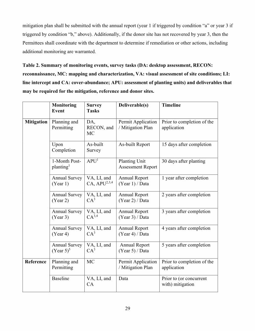
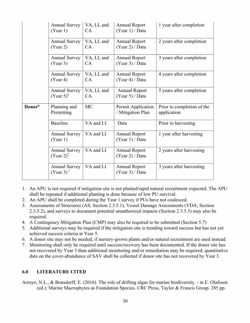
Table 2. Summary of monitoring events, survey tasks (DA: desktop assessment, RECON:
reconnaissance, MC: mapping and characterization, VA: visual assessment of site conditions; LI:
line intercept and CA: cover-abundance; APU: assessment of planting units) and deliverables that
may be required for the mitigation, reference and donor sites.
Monitoring Event
Survey Tasks
Deliverable(s) Timeline
Mitigation Planning and Permitting
DA, RECON, and MC
Permit Application / Mitigation Plan
Prior to completion of the application
Upon Completion
As-built Survey
As-built Report 15 days after completion
1-Month Post-planting1
APU1 Planting Unit Assessment Report
30 days after planting
Annual Survey (Year 1)
VA, LI, and CA, APU2,3,4
Annual Report (Year 1) / Data
1 year after completion
Annual Survey (Year 2)
VA, LI, and CA3
Annual Report (Year 2) / Data
2 years after completion
Annual Survey (Year 3)
VA, LI, and CA3,4
Annual Report (Year 3) / Data
3 years after completion
Annual Survey (Year 4)
VA, LI, and CA3
Annual Report (Year 4) / Data
4 years after completion
Annual Survey (Year 5)5
VA, LI, and CA3
Annual Report (Year 5) / Data
5 years after completion
Reference Planning and Permitting
MC Permit Application / Mitigation Plan
Prior to completion of the application
Baseline VA, LI, and CA
Data Prior to (or concurrent with) mitigation
29
Annual Survey (Year 1)
VA, LI, and CA
Annual Report (Year 1) / Data
1 year after completion
Annual Survey (Year 2)
VA, LI, and CA
Annual Report (Year 2) / Data
2 years after completion
Annual Survey (Year 3)
VA, LI, and CA
Annual Report (Year 3) / Data
3 years after completion
Annual Survey (Year 4)
VA, LI, and CA
Annual Report (Year 4) / Data
4 years after completion
Annual Survey (Year 5)5
VA, LI, and CA
Annual Report (Year 5) / Data
5 years after completion
Donor6 Planning and Permitting
MC Permit Application / Mitigation Plan
Prior to completion of the application
Baseline VA and LI Data Prior to harvesting
Annual Survey (Year 1)
VA and LI Annual Report (Year 1) / Data
1 year after harvesting
Annual Survey (Year 2)7
VA and LI Annual Report (Year 2) / Data
2 years after harvesting
Annual Survey (Year 3) 7
VA and LI Annual Report (Year 3) / Data
3 years after harvesting
1. An APU is not required if mitigation site is not planted/rapid natural recruitment expected. The APU shall be repeated if additional planting is done because of low PU survival.
2. An APU shall be completed during the Year 1 survey if PUs have not coalesced. 3. Assessments of Structures (AS; Section 2.3.5.1), Vessel Damage Assessments (VDA; Section
2.3.5.2), and surveys to document potential unauthorized impacts (Section 2.3.5.3) may also be required.
4. A Contingency Mitigation Plan (CMP) may also be required to be submitted (Section 5.7) 5. Additional surveys may be required if the mitigation site is trending toward success but has not yet
achieved success criteria at Year 5. 6. A donor site may not be needed, if nursery-grown plants and/or natural recruitment are used instead. 7. Monitoring shall only be required until success/recovery has been documented. If the donor site has
not recovered by Year 3 than additional monitoring and/or remediation may be required; quantitative data on the cover-abundance of SAV shall be collected if donor site has not recovered by Year 3.
6.0 LITERATURE CITED
Arroyo, N.L., & Bonsdorff, E. (2016). The role of drifting algae for marine biodiversity. - in E. Olafsson (ed.): Marine Macrophytes as Foundation Species. CRC Press, Taylor & Francis Group. 285 pp.
30
DEP. (2020) Guidance on Surveys for Potential Impacts to Submerged Aquatic Vegetation.
Deepwater Horizon Natural Resource Damage Assessment Trustees. (2016). Deepwater Horizon oil spill: Final Programmatic Damage Assessment and Restoration Plan and Final Programmatic Environmental Impact Statement. Retrieved from: http://www.gulfspillrestoration.noaa.gov/restoration-planning/gulf-plan. Accessed August 2020.
Fonseca, M.S., Kenworthy, J.W., & Thayer, G.W. (1998) Guidelines for the conservation and restoration of seagrasses in the United States and adjacent waters. US Department of Commerce, National Oceanic and Atmospheric Administration, Coastal Ocean Office
FWC. (2003) Florida Seagrass Manager’s Toolkit. Retrieved from: https://myfwc.com/research/habitat/seagrasses/publications/manager-toolkit-2003/. Accessed August 2020.
Handley, L., Lockwood, C., Spear, K., Finkbeiner, M., & Kenworthy, J.W. (2018) A Seagrass Monitoring Approach for the Gulf of Mexico for the Gulf of Mexico Alliance (GOMA) Gulf Star Award 2017 Habitat Resources Team. Retrieved from: https://gulfofmexicoalliance.org/wp-content/uploads/2020/06/A-Seagrass-Monitoring-Approach-for-the-Gulf-of-Mexico-2020_brochure.pdf. Accessed August 2020.
South Atlantic Fishery Management Council. 1998. Comprehensive Amendment addressing Essential Fish Habitat in Fishery Management Plans of the South Atlantic Region. Retrieved from: https://safmc.net/habitat-and-ecosystems/safmc-habitat-plan/. Accessed August 2020.
31