Embed Size (px)
Citation preview

Guidance on the Authorisation of Discharges to Groundwater
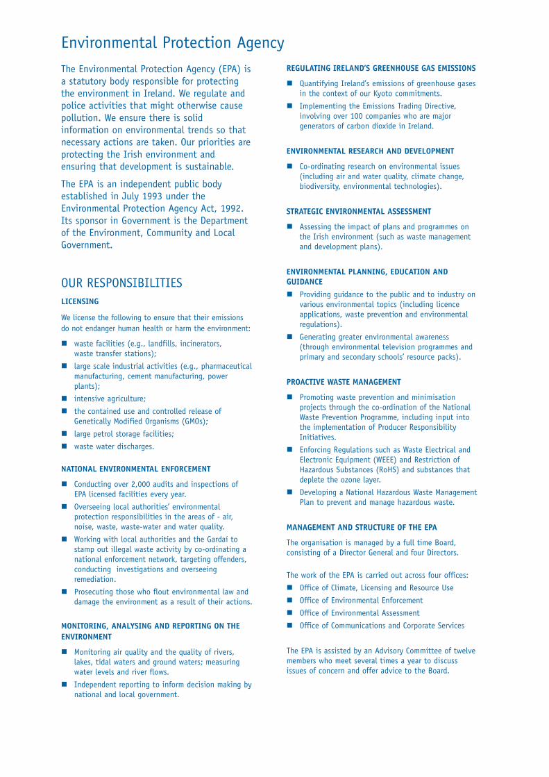
Environmental Protection Agency
The Environmental Protection Agency (EPA) isa statutory body responsible for protectingthe environment in Ireland. We regulate andpolice activities that might otherwise causepollution. We ensure there is solidinformation on environmental trends so thatnecessary actions are taken. Our priorities areprotecting the Irish environment andensuring that development is sustainable.
The EPA is an independent public bodyestablished in July 1993 under theEnvironmental Protection Agency Act, 1992.Its sponsor in Government is the Departmentof the Environment, Community and LocalGovernment.
OUR RESPONSIBILITIESLICENSING
We license the following to ensure that their emissionsdo not endanger human health or harm the environment:
� waste facilities (e.g., landfills, incinerators,waste transfer stations);
� large scale industrial activities (e.g., pharmaceuticalmanufacturing, cement manufacturing, powerplants);
� intensive agriculture;
� the contained use and controlled release ofGenetically Modified Organisms (GMOs);
� large petrol storage facilities;
� waste water discharges.
NATIONAL ENVIRONMENTAL ENFORCEMENT
� Conducting over 2,000 audits and inspections ofEPA licensed facilities every year.
� Overseeing local authorities’ environmentalprotection responsibilities in the areas of - air,noise, waste, waste-water and water quality.
� Working with local authorities and the Gardaí tostamp out illegal waste activity by co-ordinating anational enforcement network, targeting offenders,conducting investigations and overseeingremediation.
� Prosecuting those who flout environmental law anddamage the environment as a result of their actions.
MONITORING, ANALYSING AND REPORTING ON THEENVIRONMENT
� Monitoring air quality and the quality of rivers,lakes, tidal waters and ground waters; measuringwater levels and river flows.
� Independent reporting to inform decision making bynational and local government.
REGULATING IRELAND’S GREENHOUSE GAS EMISSIONS
� Quantifying Ireland’s emissions of greenhouse gasesin the context of our Kyoto commitments.
� Implementing the Emissions Trading Directive,involving over 100 companies who are majorgenerators of carbon dioxide in Ireland.
ENVIRONMENTAL RESEARCH AND DEVELOPMENT
� Co-ordinating research on environmental issues(including air and water quality, climate change,biodiversity, environmental technologies).
STRATEGIC ENVIRONMENTAL ASSESSMENT
� Assessing the impact of plans and programmes onthe Irish environment (such as waste managementand development plans).
ENVIRONMENTAL PLANNING, EDUCATION ANDGUIDANCE � Providing guidance to the public and to industry on
various environmental topics (including licenceapplications, waste prevention and environmentalregulations).
� Generating greater environmental awareness(through environmental television programmes andprimary and secondary schools’ resource packs).
PROACTIVE WASTE MANAGEMENT
� Promoting waste prevention and minimisationprojects through the co-ordination of the NationalWaste Prevention Programme, including input intothe implementation of Producer ResponsibilityInitiatives.
� Enforcing Regulations such as Waste Electrical andElectronic Equipment (WEEE) and Restriction ofHazardous Substances (RoHS) and substances thatdeplete the ozone layer.
� Developing a National Hazardous Waste ManagementPlan to prevent and manage hazardous waste.
MANAGEMENT AND STRUCTURE OF THE EPA
The organisation is managed by a full time Board,consisting of a Director General and four Directors.
The work of the EPA is carried out across four offices:
� Office of Climate, Licensing and Resource Use
� Office of Environmental Enforcement
� Office of Environmental Assessment
� Office of Communications and Corporate Services
The EPA is assisted by an Advisory Committee of twelvemembers who meet several times a year to discussissues of concern and offer advice to the Board.

VERSION 1 DECEMBER 2011
GUIDANCE ON THE AUTHORISATION OF
DISCHARGES TO GROUNDWATER

ii
Acknowledgements
This Guidance Manual was prepared on behalf of the EPA by Henning Moe and Lorraine Gaston, CDM Ireland Ltd. A steering committee was established to monitor progress and guide the different
phases of the study. The membership of the steering committee was as follows: Donal
Daly (EPA) (Chairperson), Colin Byrne (Department of Environment, Heritage and Local
Government), Brendan Cooney (Wexford County Council), David Flynn (EPA), Aoife
Loughnane (EPA) and Bruce Misstear (Trinity College Dublin)
The Guidance Manual was reviewed by the following peer review group prior to
finalisation: David Ball (Consultant), Jenny Deakin (Trinity College Dublin; formerly
Head, Groundwater Section, Department of Primary Industries and Water, Tasmania),
Laurence Gill (Trinity College Dublin), Anne Goggin (Limerick County Council), Taly
Hunter Williams (Geological Survey of Ireland) and Geoff Wright (formerly Geological
Survey of Ireland).
Preparation of this Guidance Manual benefited from the availability of a SEPA (2010) report entitled ‘Assigning Groundwater Assessment Criteria for Pollutant Inputs’. Many of the images were derived from SEPA (2010) and from the www.wfdvisual.com website hosted by SNIFFER.
Disclaimer
Although every effort has been made to ensure the accuracy of the material contained in this publication, complete accuracy cannot be guaranteed. Neither the Environmental Protection Agency nor the author(s) accept any responsibility whatsoever for loss or damage occasioned, or claimed to have been occasioned, in part or in full as a consequence of any person acting or refraining from acting, as a result of a matter contained in this publication. All or part of this publication may be reproduced without further permission, provided the source is acknowledged.
Published by the Environmental Protection Agency
An Ghníomhaireacht um Chaomhnú Comhshaoil Johnstown Castle
Wexford Ireland
Telephone: +353 53 916 0600 LoCall: 1890 33 55 99 Fax: +353 53 916 0699
Email: [email protected] Website: www.epa.ie
08/11/web only
ISBN 978-1-84095-413-5 Report available on EPA website www.epa.ie

i
Table of Contents
1.1 Purpose ................................................................................................................................... 1 1.2 Scope ...................................................................................................................................... 1 1.3 Legislative Background ........................................................................................................... 2 1.4 Reference Documents ............................................................................................................ 2
2.1 ‘Prevent or Limit’ Objective ..................................................................................................... 5 2.2 Chemical Status ...................................................................................................................... 6 2.3 Significant and Sustained Upward Trends.............................................................................. 7 2.4 Definition of Inputs .................................................................................................................. 8 2.5 Exemptions ............................................................................................................................. 9
3.1 Source-Pathway-Receptor Model ......................................................................................... 10 3.2 Receptor Types ..................................................................................................................... 11 3.3 Key Questions ....................................................................................................................... 15 3.4 Receptor-Based Water Quality Standards ............................................................................ 16 3.5 Capacity ................................................................................................................................ 17 3.6 Receptors, Compliance Points and Concentrations ............................................................. 18 3.7 Cumulative Impacts .............................................................................................................. 21
4.1 SPR Risk Factors .................................................................................................................. 23 4.2 Assessment Methodology ..................................................................................................... 25 4.3 Tiers of Assessment ............................................................................................................. 30 4.4 Site Investigation Best Practice ............................................................................................ 40
5.1 Introduction ........................................................................................................................... 41 5.2 Assessing the Need for Compliance Monitoring ................................................................... 42 5.3 Selection of Compliance Points ............................................................................................ 42 5.4 Representative Samples ....................................................................................................... 48 5.5 Substances to be Analysed .................................................................................................. 49 5.6 Frequency of Sampling ......................................................................................................... 50 5.7 Checking Compliance ........................................................................................................... 50

ii
List of Tables
Table 1: Roles of Subsurface Water in Environmental Management ................................................. 13 Table 2: Summary of Data and Information to be Considered During Risk Screening ....................... 28 Table 3: Recommended Tiers of Assessment .................................................................................... 31 Table 4: Examples of Potential Site Investigation Requirements for Different Tiers of Assessment .. 33 Table 5: Summary of Compliance Points ............................................................................................ 43 Table 6: Suggested List of Parameters for Groundwater Analysis ..................................................... 50
List of Figures
Figure 1: Direct Input Scenarios .............................................................................................................8 Figure 2: Indirect Input Scenarios ..........................................................................................................9 Figure 3: SPR Model (graphic sourced from the WFD Visual website, SNIFFER, 2007) ................... 10 Figure 4: Summary of Groundwater and Pore Water in Low Permeability Sediments ....................... 13 Figure 5: Receptors, Compliance Points and Concentrations ............................................................ 18 Figure 6: Compliance Monitoring for Multiple Receptors .................................................................... 20 Figure 7: Risk Screening of New Inputs .............................................................................................. 27 Figure 8: Proposed Review Process of Existing Inputs ...................................................................... 29 Figure 9: Steps in Estimating a Resulting Concentration in Groundwater .......................................... 38 Figure 10: Compliance Monitoring for Hazardous Substances ........................................................... 43 Figure 11: Compliance Monitoring where the Groundwater Resource is the Receptor ...................... 45 Figure 12: Compliance Monitoring where Surface Water is the Receptor .......................................... 47 Figure 13: Compliance Monitoring where a GWDTE is the Receptor ................................................. 48 Figure 14: Challenges of Monitoring Poorly Productive Aquifers ........................................................ 49 Figure 15: Checking Compliance ........................................................................................................ 51 Figure 16: Example of Sustained Upward Concentration Trend ......................................................... 52

iii
Extended Summary
Introduction
This document provides guidance on the technical assessments that are needed to authorise
discharges to groundwater, as a means of satisfying the requirements of the European Communities
Environmental Objectives (Groundwater) Regulations, 2010 (S.I. No. 9 of 2010) (Groundwater
Regulations). The authorisation of discharges to groundwater in Ireland is currently regulated and
authorised by local authorities and the EPA under legislation that predates the Groundwater
Regulations (for example, Section 4 licences are granted under the Local Government (Water
Pollution) Acts 1977 to 1990). However, despite the legislation, there is no consistent approach
towards assessing potential impacts on groundwater from new or existing discharge activities. Due to
the comprehensive nature of the Groundwater Regulations and their relation to the Water Framework
Directive (2000/60/EC) (WFD) and the Groundwater Directive (2006/118/EC) (GWD), a consistent
approach towards technical assessment is needed.
This guidance provides a practical framework for the processes, types of information, and criteria that
are considered important for granting or refusing an authorisation to discharge, or alternatively, to
point to what specific information might be needed to address technical areas of uncertainty.
Specifically, this document includes guidance on:
Risk screening for potential impact to groundwater based on considerations of pollutant
loading, toxicity, pathways and receptor types;
Appropriate levels of technical assessment for different types and scales of discharges;
Predicting impact on groundwater quality, and
Appropriate monitoring to check compliance with receptor-based water quality standards.
Due to the wide range of hydrogeological settings and levels of complexity in Irish aquifers, the
guidance cannot be prescriptive. Rather, the guidance aims to provide an overall indication of the
assessment process and the underlying principles that should be followed. As such, a specific goal of
the guidance is to achieve a future level of consistency in terms of how discharge to groundwater
applications are prepared and reviewed, and on what decisions should be based.
This guidance is primarily for Environmental Protection Agency (EPA) personnel, but is also intended
to assist local authorities, other public bodies and environmental professionals involved in the
preparation or review of discharge to groundwater applications.
Groundwater Quality Objectives
Regulation 4 of the Groundwater Regulations (S.I. No. 9 of 2010) places a duty on public authorities
to promote compliance with the requirements of the regulations and to take all reasonable steps
including, where necessary, the implementation of programmes of measures, to:
“(a) prevent or limit, as appropriate, the input of pollutants into groundwater and prevent the
deterioration of the status of all bodies of groundwater;
(b) protect, enhance and restore all bodies of groundwater and ensure a balance between
abstraction and recharge of groundwater with the aim of achieving good groundwater
quantitative status and good groundwater chemical status by not later than 22 December
2015;

iv
(c) reverse any significant and sustained upward trend in the concentration of any pollutant
resulting from the impact of human activity in order to progressively reduce pollution of
groundwater;
(d) achieve compliance with any standards and objectives established for a groundwater
dependent protected area included in the register of protected areas established under
Regulation 8 of the 2003 Regulations [S.I. No. 722 of 2003] by not later than 22 December
2015, unless otherwise specified in the Community legislation under which the individual
protected areas have been established.”
Regulation 7 of the Groundwater Regulations further states that “Point source discharges and diffuse
sources liable to cause groundwater pollution shall be controlled so as to prevent or limit the input of
pollutants into groundwater”.
This ‘prevent or limit’ objective is the core groundwater quality objective addressed by this guidance.
In principle, ‘prevent or limit’ measures are the first line of defense in restricting inputs of pollutants to
groundwater and thereby avoiding or reducing pollution. The ‘prevent’ objective relates to hazardous
substances, whereby all necessary and reasonable measures should be taken to avoid the entry of
such substances into groundwater and to avoid any significant increase in concentration in
groundwater, even at a local scale. The ‘limit’ objective relates to non-hazardous substances,
whereby all necessary measures should be taken to limit inputs into groundwater to ensure that such
inputs do not cause deterioration in status of groundwater bodies, nor significant and sustained
upward trends in groundwater concentrations.
Scope of Technical Guidance
This guidance addresses both direct and indirect discharges (inputs) to groundwater which can
originate from point sources of potential pollution. It does not cover diffuse inputs from agriculture,
such as landspreading, which are covered by other legislation, notably European Communities
(Good Agricultural Practice for Protection of Waters) Regulations 2010 (S.I. No. 610 of 2010). Point
sources that are highlighted in this guidance are:
Small scale discharges from on-site waste water treatment systems (OSWTSs) - septic tanks
and package treatment plants;
Discharges to ground from larger waste water works, including integrated constructed
wetland systems;
IPPC and other industrial/commercial releases;
Infiltration of urban stormwater through infiltration basins (Sustainable Urban Drainage
Systems); and
Escape of leachate from landfills (beyond engineered and/or geological barriers).
Historically contaminated land is referenced but is not the focus of this guidance, although it is
included in the Groundwater Regulations. The EPA is currently preparing a policy on the enforcement
of sites with contaminated land and groundwater. The EPA website – www.epa.ie/downloads – also
includes a number of papers and publications of general interest to those managing historically
contaminated land.
Under Regulation 14 of the Groundwater Regulations, the EPA (as the responsible agency) may
establish detailed technical rules under which new inputs may be exempted from the requirement
that all measures be carried out to meet the ‘prevent and limit’ objective. The EPA is currently
considering possible technical rules for exemptions. Categories of possible exempted inputs include
unforeseen accidental spills, return water from geothermal installations, and deliberate inputs for

v
scientific research purposes (such as groundwater tracers). Final decisions as to whether a given
planned discharge activity may be exempted will be made by the EPA on a case-by-case basis.
Context of Groundwater Chemical Status
The Groundwater Regulations require that ‘good’ status be achieved in all groundwater bodies and
associated ecosystems by 22 December 2015, subject to exemptions under certain conditions
(Regulations 16 through 19). The Groundwater Regulations also require that programmes of
measures be implemented to prevent the deterioration of status of groundwater bodies where status
is already deemed to be at least ‘good’. ‘Status’ applies to both water quantity (quantitative status)
and quality (chemical status). A classification of chemical status of Irish groundwater bodies was
completed by the EPA in 2011; the information can be accessed on the EPA website –
http://gis.epa.ie .
Generally, the chemical status classification reflects regional trends and patterns rather than local-
scale impacts. Inputs from point sources such as those described in this guidance tend to have
localised impacts. Localised pollution may exist within a larger groundwater body that is at good
chemical status. However, in circumstances where the groundwater body is classed as ‘poor’ or
where classed as ‘good’ but with limited capacity to accept more pollutants, the impact of further
pollutant input would need to be considered before authorisation is granted.
The EPA’s status classification will be reviewed every six years in line with WFD river basin
management plan cycles. As such, the EPA is monitoring trends of concentrations of substances in
groundwater via a national groundwater monitoring network. Trend assessment of monitoring data is
part of the classification process. Where upward trends are significant and sustained, they must be
reversed by introducing appropriate mitigation measures.
Public authorities therefore must review new discharge to groundwater applications in the context of
the existing status of the relevant groundwater body, within which the proposed discharge activity is
located.
Regulation 56 of the Groundwater Regulations requires that trend assessments be carried out on
individual plumes resulting from point sources and contaminated land where the achievement of the
objectives of Article 4 of the WFD are threatened. This implies that trend assessment must be carried
out for discharge to groundwater activities that require monitoring. This is to verify that new inputs do
not cause deterioration in the chemical status of the groundwater body and do not present a risk to
human health and the environment (receptors).
Approach
The technical assessment of a discharge to groundwater activity is risk-based and receptor-focussed,
and follows the source-pathway-receptor (SPR) model which underpins all groundwater protection
schemes in Ireland as well as the WFD on which the Groundwater Regulations are based. Every
discharge activity carries a degree of risk (of impact on groundwater quality and receptors). The
challenge lies in differentiating between degrees of risk and assigning appropriate effort and
resources where the risk is higher. When examining SPR relationships, the main questions to be
considered are:
Source characterisation – how significant is the potential discharge (input)?
Pathways analysis – how and where would a pollutant flow, and to what extent would the
pollutant be expected to attenuate? Is there a hydrological link that can deliver a pollutant to
a nearby receptor?
Receptor identification – who or what would potentially be affected?

vi
Methodology
The technical assessment methodology is aimed at examining SPR relationships, specifically:
Demonstrating that a site has sufficient infiltration capacity to physically “accept” the
effluent, thereby avoiding surface ponding and effluent runoff;
Demonstrating that a site has adequate attenuation potential to limit the loading of
substances to groundwater;
In certain cases, predicting an impact on groundwater quality;
Where necessary, verifying predicted impacts by checking compliance with relevant
groundwater quality objectives and standards.
The methodology involves an initial risk screening procedure summarised in Figure ES-1. The
outcome of the risk screening is a judgement of the degree of risk posed by the discharge activity to
groundwater quality and receptors, and then determining an appropriate level of technical site
assessment needed to demonstrate site suitability and, if relevant, to estimate chemical loading and
a predicted impact.
Crucially, the level of technical assessment should be proportionate to the risk posed by the
discharge activity. Three tiers of assessment are defined, which in theory involve increasing degrees
of complexity. Guidance is provided on the types of data and information that might be needed for
prior site investigation for each tier of assessment. However, as details of site-specific investigations
cannot be prescribed, professional judgement will be involved for the more complex cases, using a
“weight of evidence” approach.
Tier 1 Assessment
Tier 1 assessments cover low-risk activities. The most significant discharge activity in this category is
effluent from on-site waste water treatment systems (OSWTSs) of less than 5 m3/d. A typical Tier 1
assessment should, therefore, follow the characterisation procedures described in the EPA Code of
Practice (CoP) for OSWTSs for single houses. No other requirements are specified. The CoP is
designed to demonstrate site suitability. Provided the site characterisation form that accompanies the
CoP is completed, the subsoil permeability and thickness is suitable and the infiltration (percolation)
values are satisfactory, authorisation may be granted. Engineering measures to improve infiltration
capacity and attenuation potential can be considered. The authorisation would be subject to best
practice with regard to proper operation and maintenance of any OSWTS, as directed by the DEHLG
circular on performance of OSWTSs (dated 19 October 2010). If there is uncertainty about results,
further site investigation may be needed, akin to the Tier 2 assessment described below.
Tier 2 Assessment
Tier 2 assessments generally cover moderate risk activities, including:
Inputs greater than 5 m3/d and less than or equal to 20 m
3/d of domestic waste water
associated with OSWTS and integrated constructed wetlands (ICWs); and
Trade effluent where risk screening indicates a moderate risk of impact.
As with Tier 1, a Tier 2 site assessment must demonstrate sufficient infiltration capacity and
adequate attenuation potential. However, Tier 2 assessments also involve the prediction of an impact
on groundwater quality using basic calculation procedures.
A Tier 2 assessment requires subsoil characterisation, possibly from boreholes drilled if the depth to
bedrock is beyond the safe limit of trial holes. Trial holes are favoured where they can be excavated

vii
safely, as they expose a larger area of subsoil and provide a clearer image of subsoil characteristics.
Besides lithological information and establishing depths to bedrock, the subsoil characterisation
should provide estimates of subsoil permeability which can subsequently be used to estimate
(calculate) infiltration capacity.
A Tier 2 assessment also requires groundwater characterisation involving the drilling and testing of
boreholes and, possibly, the construction of monitoring wells for water level monitoring and sampling
purposes. The number of boreholes and/or monitoring wells that may be needed for site
characterisation and monitoring cannot be prescribed, but is a function of the size of the discharge
activity and the conceptual hydrogeological model of the site. The level of detail needed is case-
specific, but the objective is to provide representative hydrogeological data. A Tier 2 assessment
must, therefore, be carried out by a suitably qualified person.
Tier 3 Assessment
Tier 3 assessments generally cover these higher risk activities:
Inputs greater than 20 m3/d of domestic waste water;
Landfills;
Any other proposed activity that is screened as carrying a high risk of impact on a receptor;
and
Any discharge activities where the results of an initial Tier 1 or Tier 2 assessment indicate
significant scientific uncertainty.
The Tier 3 assessment has the same objectives and general content as in Tier 2, but the level of
technical detail is greater. Subsoil characterisation has these additional requirements:
Continuous subsoil sampling to bedrock (e.g., split-spoon samples or coring);
Grain size analyses, including the clay fraction; and
Estimation of subsoil permeability from field permeability tests or laboratory testing (e.g. for
vertical hydraulic conductivity), the latter being especially important when clays are present.
Groundwater characterisation has these additional requirements:
Pumping tests, rather than rising or falling head tests, are the preferred and accepted means
of estimating hydraulic properties of the aquifer underlying the site, provided meaningful tests
can be carried out (this may not always be the case in certain hydrogeological settings).
As with Tier 2, the number of boreholes and pumping and/or monitoring wells that may be needed for
site characterisation and monitoring cannot be prescribed, but is a function of the size of the
discharge activity and the conceptual hydrogeological model of the site. The objective is to produce
representative hydrogeological data of subsoil characteristics as well as groundwater flow gradients,
fluxes and quality. A Tier 3 assessment must be carried out by a suitably qualified person.
Cases involving waste disposal facilities should, by default, follow existing site investigation guidance
for landfills (EPA, 1995).
Predicting an Impact on Groundwater Quality
Predicting a potential impact on groundwater quality and associated receptors through Tier 2 and
Tier 3 assessments involves estimation and/or calculation of:
Hydraulic loading to groundwater;
viii
Chemical loading to groundwater; and
Resulting concentrations of substances of concern that can be expected in groundwater
following mixing between the effluent and groundwater.
The calculations (presented in Appendix E) make use of the site-specific data collected during the
prior site investigation(s). The prediction requires estimates of the natural groundwater flux in the
aquifer and the background concentration of the substance(s) of concern up-gradient of the planned
discharge activity (i.e. before the projected input).
Authorisation can be granted provided site suitability is demonstrated and the predicted groundwater
quality impact is deemed to be acceptable with respect to groundwater quality objectives and
relevant receptor-based water quality standards. If the input is predicted to result in an unacceptable
increase in concentrations and/or impact on receptors, authorisation may not be granted. In this
case, the applicant may propose engineering or source control measures (e.g. improved treatment)
in order to reduce the chemical loading to groundwater in a revised application.
Compliance Monitoring
Discharge activities that involve OSWTSs and discharge rates less than 5 m3/d are authorised
subject to best practice with regard to proper operation and maintenance, but the terms of
authorisation typically do not include any groundwater monitoring. In contrast, discharge activities
that are subject to Tier 2 and 3 assessments will typically have to undertake compliance monitoring
to: a) verify predicted impact and b) check compliance with the terms of the authorisation. These
dictate that receptor-based water quality standards (or threshold values) should not be exceeded at
receptor locations (e.g., drinking water standard at a public supply well). For this reason, sampling is
conducted to monitor water quality at receptors, as appropriate.
Sampling should also be carried out at one or more intermediate points between the discharge point
and the receptor. The purpose is to “protect” the receptor from being impacted. Thus, if the water
quality at the intermediate point is impacted above some assigned value (concentration), then the
receptor is also likely to be impacted (i.e. the water quality standard might be exceeded) at a future
date.
An intermediate sampling point is referred to as a compliance point. It must be representative of the
hydrogeological characteristics of the site in question. Groundwater samples must be collected from
the “correct” pathway – that is, the location and vertical depth interval or intervals that transmit the
highest groundwater flux and concentrations of pollutant substances from the pollution source. This
can only be achieved with the development of a sound conceptual hydrogeological model and a prior
site investigation that identifies and quantifies the major pathways. This is particularly important for
bedrock aquifers where multiple groundwater pathways may exist and clustered wells at different
depths may be needed.
Compliance monitoring should also take into consideration data or information on background and/or
up-gradient concentrations in groundwater in order to be able to draw appropriate conclusions about
impacts on groundwater quality.
Compliance Checking
The terms of an authorisation should specify requirements for compliance points, compliance
monitoring and compliance values. Compliance checking involves comparing groundwater quality
data from the compliance point(s) to a specified compliance value(s).
The compliance value is the concentration of a specific substance at a compliance point that will
ensure its relevant water quality standards at a receptor. If exceeded at the compliance point,

ix
compliance has not been achieved. In this case, source control measures may have to be initiated or
modified to reduce (further limit) loading to groundwater.
Compliance values and water quality standards are linked to specific receptors. There are four types
of groundwater-related receptors:
The groundwater resource itself (the aquifer);
Groundwater abstraction points (water supplies);
Surface waters (rivers, lakes, transitional and coastal waters); and
Groundwater dependent terrestrial ecosystems (GWDTEs, groundwater dependent
wetlands).
The term receptor is used in its widest context to include not only the existing uses of groundwater
but all plausible and legitimate future uses and functions of the groundwater.
Where the receptor is the groundwater resource (aquifer), and especially where the resource is used
for water supply, the compliance value would, in most Irish bedrock aquifers, be defined by relevant
groundwater quality standards. This is because attenuation processes in bedrock aquifers are mostly
limited to mixing and dilution in groundwater beneath the source, with limited further attenuation
expected in a down-gradient flow direction. In sand and gravel aquifers, however, attenuation
processes such as dispersion, sorption and biodegradation can be more significant. In such cases,
the compliance value could be set as a higher concentration than the groundwater quality standard
for the receptor.
Where the receptor is a surface water, environmental quality standards apply in accordance with the
European Communities Environmental Objectives (Surface Water) Regulations 2009 (S.I. No. 272 of
2009), and the compliance value is the concentration of a substance in groundwater that does not
result in the EQS being exceeded after mixing (dilution) between groundwater and the surface water.
Where the receptor is a GWDTE, no statutory standards exist because different types of GWDTEs
have different groundwater dependencies, and often, single ecosystems include species with
different needs and sensitivities. Cases involving GWDTEs will involve prior consultation with, and
participation of, the NPWS, and may involve detailed ecological characterisation. Where the GWDTE
is also a Natura 2000 site, an Appropriate Assessment must be prepared, as required by the EC
Habitats Directive.
Principles of Monitoring
Groundwater monitoring does not, of itself, protect the environment. In circumstances where a
development exists or is proceeding, emphasis should be given to groundwater pollution prevention
by means of best practice (careful location, adequate design, proper construction, and
implementation of O&M protocols, etc.).
Nonetheless, groundwater monitoring is an important component of compliance checking, where
needed. Effective monitoring of groundwater in the vicinity of potentially polluting developments is
challenging in Ireland due to the complex hydrogeological settings present in many areas.
A commonly-taken approach to monitoring in regulatory guidance in many countries is to require a
standard number of monitoring points in the vicinity of developments – usually one up-gradient and
two down-gradient (as a minimum). While there are circumstances where this approach is justifiable,
it is not recommended in this guidance document for all situations.
Monitoring in the vicinity of developments has some or all of the following objectives:

x
To determine baseline conditions.
To gain an improved understanding of the geological and hydrogeological conditions.
To obtain an early warning of an impact associated with the emissions from a development.
To assess environmental impact.
To provide reassurance to the regulators and local groundwater users.
To comply with an authorisation.
The recommended approach to designing compliance monitoring networks is as follows:
The network design should be based on a sound conceptual hydrogeological model for the
site.
The network must be representative of the main pathways that would enable pollutant
migration away from the site;
The number of boreholes, piezometers and monitoring wells needed for a given site should
be based on the physical size of the activity, an evaluation of the predicted risk, the pollutant
load, the likelihood of pollutant migration away from the site, and the receptor sensitivity.
Where other pollutants may be arising or are likely to arise up-gradient of the site (from other
activities), monitoring in that area may be advisable.
The substances to be monitored in groundwater should reflect the type of effluent and the
substances of concern in the effluent. The frequency of groundwater monitoring should reflect the
temporal nature of the discharge activity and the hydrogeological characteristics of the site and
associated receptors. A sampling regime in a sand and gravel aquifer would be very different from
one involving karstic limestones.
Where a discharge activity involves a risk of impact on groundwater abstraction points and surface
water receptors, sampling at the receptor locations will be needed to prove/disprove impact. Lastly,
sites involving karstic limestone and surface water receptors would also have to include
consideration of flow measurements of springs and rivers/streams, if such flow data do not already
exist.
Conclusion
The Groundwater Regulations (S.I. No. 9 of 2010) introduced groundwater quality objectives to which
public authorities have a duty to respond, both in terms of promoting compliance with the
requirements of the regulations and taking all reasonable steps to ‘prevent and limit’ the inputs of
pollutant substances to groundwater. This technical guidance has been prepared to assist public
authorities in this capacity, with the primary aim of introducing a consistent approach and
methodology as to how new discharge activities should be assessed, how to reach a defensible
decision as to whether the activity should be authorised or not, and what steps or mitigation actions
might be needed in order to grant authorisation.
The technical guidance, therefore, focuses on the technical assessment that should be considered
for a new discharge to groundwater activity, whereby the activities are first screened for risk of
potential impact, and a decision is taken with regard to the level of technical assessment that may be
required to demonstrate that a site:
Is hydraulically suitable and has sufficient infiltration capacity; and
Has sufficient attenuation capacity to ensure that the discharge will not result in an
unacceptable impact on receptors and non-compliance with groundwater quality standards
and objectives.

xi
The scope and degree of complexity of technical assessment should be proportional to the risk
posed and the hydrogeological setting of the site, whereby details of the technical assessment
should address questions surrounding source-pathway-receptor risk factors and relationships, as
governed by the conceptual model of the site.
Where risk of impact is identified, the impact should be quantified and verified through monitoring.
The nature and scope of the monitoring should be guided by the conceptual model of the site and a
site-specific understanding of potential pollutant pathways. The monitoring should be both
proportional and representative: proportional to the specific nature of the pollutant types and
magnitude of potential problem; representative in the sense that sampling points have to ‘intercept’
the pollution migration (pathways) away from the pollution source.
In summary, this Guidance provides the following:
A framework for considering discharges to groundwater;
Details on the information needed on which to base decisions;
An emphasis on conceptual understanding and particularly of considering the 3-dimensional
flow regimes beneath sites;
Background details on legislation, relevant water quality standards and relevant calculations.
This is the first version of the Guidance; it may be reviewed based on feedback from practitioners
using the Guidance.

xii
Figure ES1: Risk Screening of New Inputs

xiii
Acronyms
BAT Best Available Techniques CIS Common Implementation Strategy CoP Code of Practice DEHLG Department of Environment Heritage and Local Government DNAPL Dense Non-aqueous Phase Liquid EA Environment Agency (England & Wales) EC European Commission EPA Environmental Protection Agency EQS Environmental Quality Standard EU European Union GPZ Groundwater Protection Zone GSI Geological Survey of Ireland GWB Groundwater Body GWD Groundwater Directive (European Union) GWDTE Groundwater Dependent Terrestrial Ecosystem GWPR Groundwater Protection Responses ICWs Integrated Constructed Wetlands IPPC Integrated Pollution Prevent Control K Hydraulic Conductivity lcd Litres Per Capita Per Day LNAPL Light Non-aqueous Phase Liquid NPWS National Parks and Wildlife Agency OPW Office of Public Works OSWTSs Onsite Waste water Treatment Systems PAH Polycyclic Aromatic Hydrocarbons p.e. Population Equivalent PPAs Poorly Productive Aquifers RBD River Basin District RBMP River Basin Management Plan SAC Special Area of Conservation SEPA Scottish Environmental Protection Agency SI Inner Source Protection Area SO Outer Source Protection Area SPR Source-Pathway-Receptor SPZ Source Protection Zone UK TAG United Kingdom Technical Advisory Group TDS Total Dissolved Solids TVs Threshold Values TZ Transition Zone WCC Wexford County Council WFD Water Framework Directive (European Union) ZOC Zone of Contribution

xiv
Glossary of Terms
Agreed Limit of Detection
The lowest concentration or quantity of a substance that can be distinguished from the absence of
that substance. It should be agreed between the regulator and the applicant.
Appropriate Assessment
In accordance with Article 6(3) of the Habitats Directive (92/43/EEC), an Appropriate Assessment is
an evaluation of the potential impacts of a plan or project on the conservation objectives of a Natura
2000 site (European network of special areas of conservation and special protection areas), and the
development, where necessary, of mitigation or avoidance measures to mitigate negative effects.
Aquifer
A subsurface layer or layers of rock, or other geological strata, of sufficient porosity and permeability
to allow either a significant flow of groundwater or the abstraction of significant quantities of
groundwater (Groundwater Regulations, 2010).
Attenuation
A decrease in pollutant concentrations, flux, or toxicity as a function of physical, chemical and/or
biological processes, individually or in combination, in the subsurface environment. Attenuation
processes include dilution, dispersion, filtration, sorption, decay, and retardation.
Capacity
A measure of the ability of groundwater to assimilate or absorb pollutants whilst still maintaining
acceptable water quality in relation to applicable groundwater quality standards. The term relates
primarily to the chemical status of a groundwater body.
Coastal Water
The area of surface water on the landward side of a line, every point of which is at a distance of one
nautical mile on the seaward side from the nearest point of the baseline from which the breadth of
territorial waters is measured, extending where appropriate to the outer limit of transitional waters.
Compliance Point
The point (location, depth) at which a compliance value should be met. Generally it is represented by
a borehole or monitoring well from which representative groundwater samples can be obtained.
Compliance Value
The concentration of a substance and associated compliance regime that, when not exceeded at the
compliance point, will prevent pollution and/or achieve water quality objectives at the receptor.
Conceptual Hydrogeological Model
A simplified representation or working description of how a real hydrogeological system is believed to
behave on the basis of qualitative analysis of desk study information, field observations and field
data. A quantitative conceptual model includes preliminary calculations of water balances, including
groundwater flow.
Conservative Pollutants
Pollutants which do not readily or easily react or biodegrade in the subsurface environment.
Contaminant (Chemical) Load
The volume and concentrations of chemical substances (pollutants) discharged to soil or
groundwater.

xv
Diffuse Sources
Diffuse sources of pollution are spread over wider geographical areas rather than at individual point
locations. Diffuse sources include general land use activities and landspreading of industrial,
municipal wastes and agricultural organic and inorganic fertilisers.
Direct Input
An input to groundwater that bypasses the unsaturated zone (e.g. direct injection through a borehole)
or is directly in contact with the groundwater table in an aquifer either year round or seasonally.
Domestic Waste Water
Waste water of a composition and concentration (biological and chemical) normally discharged by a
household, and which originates predominantly from the human metabolism or from day to day
domestic type human activities, including washing and sanitation, but does not include fats, oils,
grease or food particles discharged from a premises in the course of, or in preparation for, providing
a related service or carrying on a related trade. (Water Services Act, 2007).
Down-gradient
The direction of decreasing groundwater levels, i.e. flow direction. Opposite of upgradient.
Dry Weather Flow (Effluent)
For a waste water treatment plant, the Dry Weather Flow is the average daily flow to the plant without
any contribution from stormwater inflow or infiltration of groundwater into the waste water collection
system.
Dry Weather Flow (Receiving Water)
The Dry Weather Flow of a stream or river is the annual minimum daily mean flow rate with a return
period of 50 years. The Dry Weather Flow is a statistical measure of low flow and usually requires
reliable long term low flow data or sufficient information that would allow the estimation of the Dry
Weather Flow.
Environmental Quality Standard (EQS)
The concentration of a particular pollutant or group of pollutants in a receiving water which should not
be exceeded in order to protect human health and the environment.
Good Groundwater Chemical Status
The chemical status of a body of groundwater which meets all the conditions for good chemical
status set out in Groundwater Regulations 2010, regulations 39 to 43.
Good Groundwater Status
Achieved when both the quantitative and chemical status of a groundwater body are good.
Groundwater
All water which is below the surface of the ground in the saturation zone and in direct contact with the
ground or subsoil (Groundwater Regulations, 2010). The EPA interpretation of the settings in which
groundwater can occur is presented in Section 3.2.1.
Groundwater Body (GWB)
A volume of groundwater defined as a groundwater management unit for the purposes of reporting to
the European Commission under the Water Framework Directive. Groundwater bodies are defined
by aquifers capable of providing more than 10 m3 per day, on average, or serving more than 50
persons.
Groundwater Dependent Terrestrial Ecosystems (GWDTEs)
These are groundwater dependent wetlands, whereby the dependency is either on groundwater flow,
level or chemistry as the controlling factors or qualifying interests of associated habitats. Examples
are raised bogs, alkaline fens and turloughs. Groundwater dependent terrestrial ecosystems are

xvi
listed on the EPA’s register of protected areas in accordance with Regulation 8 of the Water Policy
Regulations, 2003.
Groundwater Protection Scheme (GWPS)
A scheme comprising two principal components: a land surface zoning map which encompasses the
hydrogeological elements of risk (of pollution); and a groundwater protection response matrix for
different potentially polluting activities (DELG/EPA/GSI, 1999).
Groundwater Protection Responses (GWPR)
Control measures, conditions or precautions recommended as a response to the acceptability of an
activity within a groundwater protection zone.
Groundwater Protection Zone (GPZ)
A zone delineated by integrating aquifer categories or source protection areas and associated
vulnerability ratings. The zones are shown on a map, each zone being identified by a code, e.g.
SO/H (outer source area with a high vulnerability) or Rk/E (regionally important karstified aquifer with
an extreme vulnerability). Groundwater protection responses are assigned to these zones for
different potentially polluting activities.
Groundwater Recharge
Two definitions: a) the process of rainwater or surface water infiltrating to the groundwater table; b)
the volume (amount) of water added to a groundwater system.
Groundwater Resource
An aquifer capable of providing a groundwater supply of more than 10 m3 a day as an average or
serving more than 50 persons.
Hazardous Substances
Substances or groups of substances that are toxic, persistent and liable to bio-accumulate, and other
substances or groups of substances which give rise to an equivalent level of concern. A list of
hazardous substances has been published by the EPA (2010a).
Hydraulic Conductivity
The rate at which water can move through a unit volume of geological medium under a potential unit
hydraulic gradient. The hydraulic conductivity can be influenced by the properties of the fluid,
including its density, viscosity and temperature, as well as by the properties of the soil or rock.
Hydraulic Gradient
The change in total head of water with distance; the slope of the groundwater table or the piezometric
surface.
Indirect Input
An input to groundwater where the pollutants infiltrate through soil, subsoil and/or bedrock to the
groundwater table.
Input
The direct or indirect introduction of pollutants into groundwater as a result of human activity.
Integrated Constructed Wetlands (ICWs)
Constructed wetlands are artificially constructed or modified wetland systems supporting vegetation,
which provide secondary treatment, by physical and biological means, to effluent from a primary
treatment step. Constructed wetlands may also be used for tertiary treatment (EPA, 2009a).
“Integrated constructed wetlands” have been developed in Ireland to integrate water quality,
management of landscape-fit towards improving site aesthetics and enhancement of biodiversity.
ICWs can primarily treat domestic waste water and farmyard soiled water. Guidance (DEHLG, 2010)

xvii
is available that outlines the ICW concept, and provides information on site assessment, design,
construction, operation, maintenance and monitoring.
Integrated Pollution Prevention and Control (IPPC) Licence
A licence for industrial and other activities issued by the EPA under the Environmental Protection
Agency Acts, 1992 to 2011.
Karst
A distinctive landform characterised by features such as surface collapses, sinking streams, swallow
holes, caves, turloughs and dry valleys, and a distinctive groundwater flow regime where drainage is
largely underground in solutionally enlarged fissures and conduits.
Lake
A body of surface water, which may be artificial or natural.
Landfill
A waste disposal site or facility used for the deposit of waste onto or under land.
Limit Objective
This objective requires the implementation of all measures necessary to limit inputs of non-hazardous
substances, into groundwater to ensure that such inputs do not cause deterioration in status or
significant and sustained upward trends in their concentrations in groundwater.
Limit Value
The mass, expressed in terms of a specific parameter, concentration or level of an emission, or both
a specific concentration and level of an emission, that may not be exceeded during one or more
periods of time. In this guidance, when not exceeded at the source, the limit value will prevent an
unacceptable release to groundwater.
Minimum Reporting Value (MRV)
The lowest concentration of a substance that can be determined with a given degree of confidence
using commonly available analytical methods, primarily used in the context of hazardous substances.
MRVs are not necessarily equivalent to limits of detection. A list of substances and concentrations
considered as MRVs has been produced by the EPA and is contained in Appendix C.
Non-hazardous Substances
Pollutants listed in Schedule 2 of the Groundwater Regulations 2010 that are not considered
hazardous, as well as any other non-hazardous pollutants not listed in Schedule 2 but presenting an
existing or potential risk of pollution. Non-hazardous substances are listed in a document by the EPA
(2010a).
On-site Waste Water Treatment Systems (OSWTSs)
A generic term for small-scale waste water treatment systems associated with single houses and
small communities or facilities, and mostly associated with septic tanks and intermittent filter systems
offering secondary treatment of raw waste water effluent.
Pathway
The route which a particle of water and/or chemical or biological substance takes through the
environment from a source to a receptor location. Pathways are determined by natural
hydrogeological characteristics and the nature of the contaminant, but can also be influenced by the
presence of features resulting from human activities (e.g., abandoned ungrouted boreholes which
can direct surface water and associated pollutants preferentially to groundwater).
Permeability
A measure of a soil or rock’s ability or capacity to transmit water under a potential hydraulic gradient
(synonymous with hydraulic conductivity).

xviii
Point Source
Any discernible, confined or discrete conveyance from which pollutants are or may be discharged.
These may exist in the form of pipes, ditches, channels, tunnels, conduits, containers, and sheds, or
may exist as distinct percolation areas, integrated constructed wetlands, or other surface application
of pollutants at individual locations. Examples are discharges from waste water works and effluent
discharges from industry.
Pollution
The direct or indirect introduction, as a result of human activity, of substances or heat into the air,
water or land which may be harmful to human health or the quality of aquatic ecosystems or
terrestrial ecosystems directly depending on aquatic ecosystems which result in damage to material
property, or which impair or interfere with amenities and other legitimate uses of the environment
(Groundwater Regulations, 2010).
Poorly Productive Aquifers (PPAs)
Low-yielding bedrock aquifers that are generally not regarded as important sources of water for
public water supply but that nonetheless may be important in terms of providing domestic and small
community water supplies and of delivering water and associated pollutants to rivers and lakes via
shallow groundwater pathways.
Population Equivalent (p.e.)
A conversion value which aims at evaluating non-domestic pollution in reference to domestic
pollution fixed by EEC directive (Urban Waste Water Treatment Directive 91/271/EEC) at 60 g/day
BOD5.
Pore water
Water that occupies void spaces between mineral grains in unlithified (uncemented) sediments.
Preferential Flow
A generic term used to describe water movement along favoured pathways through a geological
medium, bypassing other parts of the medium. Examples include pores formed by soil fauna, plant
root channels, weathering cracks, fissures and/or fractures.
Prevent Objective
Taking all measures necessary and reasonable to avoid the entry of hazardous substances into
groundwater and to avoid any significant increase in their concentration in groundwater.
Receptor-based Water Quality Standards
Standards developed to protect receptors, which include drinking water standards, environmental
quality standards for surface waters and minimum reporting values. They are used to develop
compliance values for assessing inputs to groundwater.
Receptors
Receptors are existing and potential future groundwater resources, drinking water supplies (e.g.
springs and abstraction wells), surface water bodies into which groundwater discharges (e.g.
streams) and groundwater dependent terrestrial ecosystems (GWDTEs).
Regulator
In this document, the EPA or the relevant local authority depending on the type of discharge licence
and location.
River
A body of inland water flowing for the most part on the surface of the land but which may flow
underground for part of its course (Groundwater Regulations, 2010). Upland rivers are generally fast
flowing and lowland rivers are generally slow flowing and meandering.

xix
River Basin
The area of land from which all surface water run-off flows, through a sequence of streams, rivers
and lakes, into the sea at a single river mouth, estuary or delta.
River Basin District (RBD)
A group of river basins formally defined by Water Policy (2003) for the purposes of reporting Water
Framework Directive requirements to the European Commission.
River Basin Management Plan (RBMP)
A detailed document describing the characteristics of a river basin district, the environmental
objectives that need to be achieved, and the pollution control measures required to achieve these
objectives through a specified work programme.
Saturated Zone
The zone below the water table in an aquifer in which all pores and fissures and fractures are filled
with water at a pressure that is greater than atmospheric.
Section 4 Licence
A discharge licence given by local authorities under the Local Government (Water Pollution) Acts
1977 to 1990.
Significant and Sustained Upward Trend
Any statistically and environmentally significant increase in concentration of a pollutant, group of
pollutants, or indicator of pollution in groundwater (EPA, 2010b).
Soil (topsoil)
The uppermost layer of soil in which plants grow.
Source Pathway Receptor (SPR) Model
A SPR model involves identifying whether and how pollution sources are connected to a receptor via
a pathway. A conceptual model provides an understanding of all the relationships between SPR
factors in a particular hydrogeological setting.
Source Protection Area
The catchment area around a groundwater source which contributes water to that source (Zone of
Contribution), divided into two areas; the Inner Protection Area (SI) and the Outer Protection Area
(SO). The SI is designed to protect the source against the effects of human activities that may have
an immediate effect on the source, particularly in relation to microbiological pollution. It is defined by
a 100-day time of travel (TOT) from any point below the water table to the source. The SO covers the
remainder of the zone of contribution of the groundwater source.
Special Areas of Conservation (SACs)
Areas selected and designated under the Natural Habitats Regulations, 1997 (as amended in 1998
and 2005) for the protection of certain habitats and species.
Storm Water
Runoff of rainwater mainly in urban settings during high intensity rainfall events. Stormwater may
enter and discharge to groundwater or other receptors through storm drains.
Subsoil
Unlithified (uncemented) geological strata or materials beneath the topsoil and above bedrock.
Surface Water
An element of water on the land’s surface such as a lake, reservoir, stream, river or canal. Can also
be part of transitional or coastal waters. (Surface Waters Regulations, 2009.).

xx
Surface Water Bodies
Inland waters, except groundwater, which are on the land surface (such as reservoirs, lakes, rivers,
transitional waters, coastal waters and, under some circumstances, territorial waters) and which
occur within a WFD River Basin District.
Sustainable Urban Drainage Systems (SuDS)
Generic term used to describe conveyance systems and control structures designed to intercept,
manage, and dispose of surface drainage and stormwater in urban settings and the built
environment. Components of SuDS may include drains, ponds, soakaways, recharge basins, and
porous pavements.
Threshold Values (TVs)
Chemical concentration values for substances listed in Schedule 5 of the Groundwater Regulations
(2010), which are used for the purpose of chemical status classification of groundwater bodies.
Trade Effluent
Effluent from any works, apparatus, plant or drainage pipe used for the disposal to a waste water
works of any liquid (whether treated or untreated), either with or without particles of matter in
suspension therein, which is discharged from premises used for carrying on any trade or industry
(including mining), but does not include domestic waste water or storm water (Water Services Act,
2007).
Transitional Waters
Bodies of surface water in the vicinity of river mouths which are partly saline in character as a result
of their proximity to saline coastal waters, and which are substantially influenced by freshwater flows.
Trigger Level
A parameter value specified in a licence or authorisation, the achievement or exceedance of which
requires certain actions to be taken by the licensee.
UK TAG
The United Kingdom Technical Advisory Group, a partnership of UK environment and conservation
agencies set up to interpret and support the implementation of the Water Framework Directive. The
EPA is an invited member of the UK TAG.
Unacceptable Input to Groundwater
An input of hazardous substances to groundwater, or pollution resulting from an input of non-
hazardous substances to groundwater, where these inputs are not exempted by the provisions of
Regulation 14 of the Groundwater Regulations (2010).
Unsaturated Zone
The zone between the land surface and the water table, in which pores, fractures and fissures are
only partially filled with water. Also known as the vadose zone.
Vulnerability
The intrinsic geological and hydrogeological characteristics that determine the ease with which
groundwater may be contaminated by human activities (Fitzsimmons et al, 2003).
Waste Licence
A licence for activities in the waste sector given by the EPA under the Waste Management Acts,
1996 to 2010.
Waste Water Effluent
Any quantity or volume of waste water generated from a domestic, industrial, or commercial facility.
Typically disposed of via an onsite waste water treatment system or a specially designed treatment
facility such as a waste water treatment plant.

xxi
Waste Water Discharge Licence or Certificate of Authorisation
Issued by the EPA to sanitary authorities under the Waste water Discharge (Authorisation)
Regulations 2007 and 2011.
Water Body
A WFD management unit. It refers to all types of waters, including surface water bodies, transitional
and coastal water bodies, as well as groundwater bodies.
Water Table
The uppermost level of saturation in an aquifer at which the pressure is atmospheric.
Zone of Contribution (ZOC)
The area surrounding a pumped well or spring that encompasses all areas or features that supply
groundwater to the well or spring. It is defined as the area required to support an abstraction and/or
overflow (in the case of springs) from long-term groundwater recharge.

xxii

1
1 Introduction
1.1 Purpose
The purpose of this document is to provide guidance on the authorisation of discharges to
groundwater as a means of satisfying the requirements of the enacted European Communities
Environmental Objectives (Groundwater) Regulations, 2010 (S.I. No. 9 of 2010) (Groundwater
Regulations). As such, it provides a practical framework that can be used to guide the process of
preparing and reviewing applications for authorisation to discharge to groundwater. Specifically, this
document includes guidance on:
Risk posed by discharges to groundwater based on consideration of pollutant loading,
toxicity, pathways and receptor sensitivity;
Recommendations on the appropriate levels of assessment required for different types and
scales of discharges; and
Appropriate site investigation and monitoring requirements.
This guidance is for Environmental Protection Agency (EPA) personnel, but is also intended to be
helpful to other public bodies, local authorities and environmental professionals involved in the
preparation or review of applications for discharges to groundwater.
1.2 Scope
Groundwater is not only an important source of domestic and industrial water, but is also a potential
pathway for pollutants to other receptors such as streams, rivers and groundwater dependent
terrestrial ecosystems (GWDTEs). Prior authorisation of discharges to groundwater therefore must
consider the likely fate and transport of the contaminants in the subsurface environment.
This document provides guidance on both direct and indirect discharges (inputs) to groundwater
which can originate from point sources of potential pollution. It does not cover diffuse inputs from
agriculture, such as landspreading, which are covered by other legislation, notably European
Communities (Good Agricultural Practice for Protection of Waters) Regulations 2010 (S.I. No. 610 of
2010).
Point sources that are highlighted in this guidance are domestic waste water and trade effluents,
stormwater in urban areas and landfills. Examples of discharges that are covered are:
Discharges to ground from waste water works;
Small scale discharges from onsite waste water treatment systems (OSWTS) - septic tanks
and package treatment plants;
IPPC and other industrial/commercial releases;
Infiltration of urban stormwater through infiltration basins (Sustainable Urban Drainage
Systems); and
Escape of leachate from landfills (beyond engineered and/or geological barriers).

2
Historical contaminated land is referenced but is not the focus of this guidance. The EPA website –
www.epa.ie/downloads – also includes a number of papers and publications of general interest to
those managing historically contaminated land.
1.3 Legislative Background
The authorisation of discharges to groundwater is currently regulated and authorised by local
authorities and the EPA. The relevant local authority is responsible for authorising effluent and trade
discharges to waters, and the EPA is responsible for regulating activities that have significant
polluting potential, encompassing Integration Pollution Prevention and Control (IPPC) Licensing,
Waste Licensing and Waste Water Discharge Authorisation.
Discharge to groundwater licenses are granted under the following legislation:
Local Government (Water Pollution) Acts 1977 to 1990 – Section 4 Licence;
Environmental Protection Agency Acts, 1992 to 2011 – IPPC Licence;
Waste Management Acts, 1996 to 2011 – Waste Licence, Waste Facility Permit or
Certificate of Authorisation; and
Waste Water Discharge (Authorisation) Regulations 2007 and 2010 (S.I. No 684 of 2007 as
amended by S.I. No. 231 of 2010) – Waste Water Discharge Licence or Certificate of
Authorisation.
Despite the existing legislation, there is no consistent approach towards assessing or monitoring
potential pollution impacts from discharges to groundwater. With the enactment of the European
Communities Environmental Objectives (Groundwater) Regulations, 2010 (S.I. No. 9 of 2010)
(Groundwater Regulations), a more consistent approach is needed.
This guidance is therefore rooted in the Groundwater Regulations, which effectively transpose into
Irish law:
The groundwater quality objectives that must be achieved; and
The measures considered necessary to achieve the objectives, as defined by the Water
Framework Directive (2000/60/EC) (WFD) and the Groundwater Directive (2006/118/EC)
(GWD).
Groundwater quality objectives are described in Section 2.
1.4 Reference Documents
The preparation of this guidance was influenced by a range of relevant national and international
reports.
Key reference documents were:
Common Implementation Strategy for the Water Framework Directive (2000/60/EC)
Guidance on preventing or limiting direct and indirect inputs in the context of the
Groundwater Directive 2006/118/EC. Guidance Document No. 17.
UK TAG, 2008. Application of Groundwater Standards to Regulation. UK Technical Advisory
Group Paper 11b(iii).

3
The EPA has participated in the development of both documents, and their development reflects an
attempt to interpret and reconcile existing legislation with the technical and practical requirements of
the WFD and GWD.
In Ireland, important reference documents include:
EPA, 2009a. Code of Practice, Wastewater Treatment and Disposal Systems Serving Single
Houses (Population Equivalent ≤10).
EPA, 2009b. Waste Water Discharge Certificate of Authorisation: Application Guidance
Notes.
Department of the Environment, Heritage and Local Government (DEHLG), 2010. Integrated
Constructed Wetlands, Guidance Document for Farmyard Soiled Water and Domestic
Wastewater Applications.
In the context of groundwater quality protection, the EPA Code of Practice (CoP) for single houses
sets out the following:
Assessment methodology for the determination of site suitability for on-site wastewater
treatment systems (OSWTSs) and identification of the minimum environmental protection
requirements;
Methodology for the selection of suitable OSWTSs for sites in unsewered rural areas; and
Information on the design, installation and performance of conventional septic tank systems,
filter systems and mechanical aeration systems.
The EPA guidance note on waste water discharge certification follows the enactment of the Waste
Water Discharge (Authorisation) Regulations, 2007, and itemises hydrogeological and water quality
information that should be supplied with applications involving discharges from waste water treatment
plants of less than 500 population equivalent (p.e.). As highlighted in the introduction to Section F of
the guidance: “The extent of the information required is dependent on the nature and magnitude of
the discharge(s) and should be discussed in advance with the EPA”.
Similarly, the DEHLG guidance on Integrated Constructed Wetlands (ICWs) includes specifications
for site suitability assessment and groundwater protection requirements, which includes design
features to be incorporated in the construction of ICWs.
In addition to the EPA and the DEHLG, local authorities such as Wexford and Galway County
Councils have produced advice notes for discharge licensing associated with planning applications
that are generally associated with OSWTSs:
Wexford County Council, 2008. Guidelines for Water Pollution Licensing & Discharge of
Effluent to Water. Advice Note 3, Version 2.
Galway County Council, 2009. Guidelines for the Discharge of Effluent to Waters from
Industrial, Commercial Developments, and Communal Housing (> 2 House) Developments.
Advice Note 2.
These advice notes define criteria and thresholds when a discharge licence is required, identify steps
an applicant needs to take, effluent treatment standards to be achieved and general information on
the types of hydrogeological assessment that may be required. It is anticipated that this guidance
document will enable a consistent approach among all local authorities.
4
In the UK, the Environment Agency (EA) and the Scottish Environment Protection Agency (SEPA)
have published further, targeted guidance on the assessment of pollutant inputs to groundwater.
Relevant documents that have been consulted in preparing this guidance are listed below:
SEPA, 2008. The Water Environment (Controlled Activities) (Scotland) Regulations 2005. A
Practical Guide.
SEPA, 2009a. Regulatory Method (WAT-RM-04). Indirect Sewage Discharges to
Groundwater.
SEPA, 2009b. Regulatory Method (WAT-RM-06). Trade Effluent Discharges to Groundwater.
SEPA, 2010. Assigning Groundwater Assessment Criteria for Pollutant Inputs. WAT-PS-10-
01. March 2010.
Environment Agency, 2009. Hydrogeological Risk Assessment for Landfills and Derivation of
Groundwater Control and Trigger Levels.
Environment Agency, 2010a. Groundwater risk assessment of treated effluent discharges to
infiltration systems.
Environment Agency, 2010b. Assessing discharges of sewage and trade effluent to ground.
Operational Instruction 55 03. Draft.

5
2 Groundwater Quality Objectives
Regulation 4 of the Groundwater Regulations places a duty on public authorities to promote
compliance with the requirements of the regulations and take all reasonable steps including, where
necessary, the implementation of programmes of measures, to:
“(a) prevent or limit, as appropriate, the input of pollutants into groundwater and prevent the
deterioration of the status of all bodies of groundwater;
(b) protect, enhance and restore all bodies of groundwater and ensure a balance between
abstraction and recharge of groundwater with the aim of achieving good groundwater
quantitative status and good groundwater chemical status by not later than 22 December
2015;
(c) reverse any significant and sustained upward trend in the concentration of any pollutant
resulting from the impact of human activity in order to progressively reduce pollution of
groundwater;
(d) achieve compliance with any standards and objectives established for a groundwater
dependent protected area included in the register of protected areas established under
Regulation 8 of the 2003 Regulations [S.I. No. 722 of 2003] by not later than 22 December
2015, unless otherwise specified in the Community legislation under which the individual
protected areas have been established.”
Regulation 7 of the Groundwater Regulations further states that “Point source discharges and diffuse
sources liable to cause groundwater pollution shall be controlled so as to prevent or limit the input of
pollutants into groundwater”.
The ‘prevent or limit’ objective is the core groundwater quality objective addressed by this guidance.
In principle, prevent or limit measures are the first line of defense in restricting inputs of pollutants to
groundwater and thereby avoiding or reducing pollution.
The ‘prevent or limit’ objective is summarised in Section 2.1. It has a direct bearing on the other
objectives listed above, notably achieving good chemical status (Section 2.2) and reversing
significant and sustained upward pollution trends (Section 2.3).
2.1 ‘Prevent or Limit’ Objective
The ‘prevent’ objective relates to hazardous substances, whereby all necessary and reasonable
measures should be taken to avoid the entry of such substances into groundwater and to avoid any
significant increase in concentration in groundwater, even at a local scale. The term "reasonable"
means technically feasible without involving disproportionate costs.
The ‘limit’ objective relates to non-hazardous substances, whereby all necessary measures should
be taken to limit inputs into groundwater to ensure that such inputs do not cause deterioration in
status of groundwater bodies, or a significant and sustained upward trends in groundwater
concentrations.
2.1.1 Hazardous and Non-Hazardous Substances
Under Regulation 9 of the Groundwater Regulations, the EPA is required to determine which
pollutants from the indicative list of main pollutants listed in Schedule 2 are hazardous, and which are
non-hazardous.

6
Hazardous substances, in the WFD context, are substances or groups of substances that are toxic,
persistent and liable to bio-accumulate, as well as other substances or groups of substances which
give rise to an equivalent level of concern.
Non-hazardous substances are pollutants listed in Schedule 2 that are not considered hazardous, as
well as any other non-hazardous pollutants not listed in Schedule 2 but that present an existing or
potential risk of pollution. This brings substances that are unlisted and therefore excluded from
control under the previous Groundwater Directive (Directive 80/68/EEC) into the scope of the
WFD/GWD.
Substances which are considered non-hazardous have the capacity to cause pollution. However, the
mere entry into groundwater or slight deterioration in groundwater quality is not considered as
pollution. Pollution will only result where:
The substance enters groundwater in sufficient quantities to be harmful to human health or to
the quality of the aquatic ecosystems or terrestrial ecosystems directly depending on aquatic
ecosystems;
There may be damage to material property, or
There may be impairment or interference with amenities and other legitimate uses of the
environment.
A classification of hazardous and non-hazardous substances has been published by the EPA
(2010a). The report includes the methodology used to determine whether a substance is hazardous,
and provides a list of substances which are to be considered hazardous or non-hazardous. Future
substance assessments will be undertaken on an ongoing basis, with substances considered for
review and determination once they (and their respective persistence, toxicity and bioaccumulation
information) are brought to the attention of the EPA. Where a substance is determined to be
hazardous, its entry to groundwater should be prevented. Where a substance is determined to be
non-hazardous, its entry to groundwater should be limited so that it does not cause a groundwater
body to be at poor status, or result in a statistically and environmentally significant upward trend in
the concentration of the substance. The appropriate controls on hazardous and non-hazardous
substances should be reflected in the conditions that surround activities that discharge to
groundwater.
2.1.2 Microbial Pathogens
Although the Groundwater Regulations focus on chemical substances, and do not explicitly reference
microbial pathogens (e.g. coliform bacteria, E.Coli, enterococci, Cryptosproridium), these pollutants
are nonetheless covered by other statutory instruments such as the European Communities (Drinking
Water) Regulations, 2000 (S.I. 439 of 2000).
2.2 Chemical Status
The Groundwater Regulations require that ‘good’ status be achieved in all groundwater bodies and
associated ecosystems by the year 2015, subject to exemptions under certain conditions
(Regulations 16 through 19). The Groundwater Regulations also require that programmes of
measures be taken to prevent the deterioration of status of groundwater bodies where status is
already deemed to be ‘good’.
Status applies to both water quantity (quantitative status) and quality (qualitative status). An interim
classification of chemical status of Irish groundwater bodies was applied by the EPA in 2009 (EPA,
2009) and formally reported to the European Commission (EC) as required by the European
Communities (water policy) Regulation of 2003 (S.I. No. 722 of 2003) (Water Policy Regulations).

7
The assessment of chemical status will be repeated every six years, in line with river basin
management plan cycles. The 2009 interim status classification serves as the first “snapshot” in time
of the chemical status of groundwater resources at a national scale. This was up-dated in 2011 and
the results are available on the EPA website – http://gis.epa.ie .
The chemical status classification involves carrying out five basic “tests” on groundwater bodies
throughout Ireland, using an EPA-published methodology (EPA, 2010b) for assessing groundwater
quality (monitoring) data. The data are reviewed against certain thresholds and criteria (e.g.
environmental quality objectives, water quality standards) defined by the EPA method. The five tests,
which are summarised in Schedule 7 of the Groundwater Regulations, relate to:
Presence of saline or other intrusion;
Impact of groundwater on surface waters (chemical or ecological objectives);
Impact on groundwater dependent terrestrial ecosystems (GWDTEs);
Impact on drinking water protected areas; and
General chemical assessment of groundwater quality.
For the assignment of status, the EPA uses drinking water standards established for nitrate and
active substances in pesticides, and threshold values for pollutants or indicators of pollutants that are
defined by Schedules 4, 5 and 6 of the Groundwater Regulations. Groundwater quality data are
compared to these standards and threshold values. The data are sourced from a national
groundwater monitoring programme that was established by the EPA in 2006 for WFD reporting
purposes (EPA, 2006). The monitoring programme involves routine sampling from a network of
approximately 280 wells and springs, many of which serve as abstraction points for group water and
public water supply schemes.
Routine monitoring of these sites has been conducted since early 2007, and samples are analysed
for a wide range of hazardous and non-hazardous substances. By also supporting important
research programmes during the first WFD implementation cycle (2006–2015), the EPA has vastly
improved the knowledge of groundwater quality conditions and hydrogeological processes in Ireland.
The EPA’s status classification of groundwater bodies explores regional trends and patterns rather
than local-scale impacts. Inputs from point sources such as those described in this guidance tend to
have local-scale impacts. Under the WFD, it is quite possible to have localised pollution within a
larger groundwater body that is at good chemical status. However, the more widespread pollution
becomes, the more likely the groundwater body will eventually be at poor status.
It is also important to note that even if a groundwater body, or group of groundwater bodies, is
assigned ‘poor’ chemical status, this does not necessarily mean or imply that further inputs from new
discharge activities will be denied, especially where the predicted or actual impact is confined to a
small area or volume of groundwater. New discharge applications will be reviewed on a case-by-case
basis with regard to the overall risk of impact from the new proposed activity. This is described further
in Section 4 and an example of possible relevant calculations is given in Appendix E.
2.3 Significant and Sustained Upward Trends
A ‘significant and sustained upward trend’ means any statistically and environmentally significant
increase in concentration of a pollutant, group of pollutants, or indicator of pollution in groundwater.
Procedures for assessment of trends and trend reversal are outlined in Schedule 8 of the
Groundwater Regulations and are included in a methodology published by the EPA (2010b). Where

8
statistically and environmentally significant upward trends are identified, these must be reversed by
introducing appropriate control measures at the source. In addition to addressing ‘poor‘ status
groundwater bodies, the purpose of control measures is also to ensure that ‘good’ status of relatively
unpolluted groundwater bodies is maintained.
In addition to the trend assessment of groundwater bodies, Regulation 56 of the Groundwater
Regulations also requires that trends assessments be carried out on plumes resulting from known
point sources and contaminated land. This is to monitor and verify that plumes from known sources
do not expand, do not cause deterioration in the chemical status of the groundwater body, and do not
present a risk to human health and the environment.
2.4 Definition of Inputs
The Groundwater Regulations define an input of pollutants as the direct or indirect introduction of
pollutants into groundwater as a result of human activity. The term “input” is different from “discharge”
in that it covers all pollutants that enter groundwater, and is not restricted to deliberate disposals. The
term input therefore covers a broader range of scenarios/situations, including diffuse sources of
groundwater pollution. As stated in Section 1, diffuse sources of pollution are not included in this
guidance.
2.4.1 Direct Inputs
Figure 1, sourced from the Common Implementation Strategy Guidance No. 17 (CIS, 2007), shows
scenarios of direct input to groundwater, whereby the source of pollution:
Bypasses the unsaturated zone (e.g. direct injection through a borehole);
Is directly in contact with the groundwater table (saturated zone); and/or
Is periodically in contact with the groundwater table due to seasonal groundwater
fluctuations.
Regulation 8 of the Groundwater Regulations prohibits the direct input of all hazardous and non-
hazardous polluting substances into groundwater. However, there are cases where exemptions may
apply (see Section 2.5 and Appendix A). Direct discharge exemptions are subject to prior
authorisation irrespective of type.
Figure 1: Direct Input Scenarios

9
2.4.2 Indirect Inputs
Figure 2, also sourced from CIS (2007), shows scenarios of indirect inputs whereby:
Pollutants percolate/infiltrate to the groundwater table through an unsaturated zone; and
The source of pollution is located above the groundwater table all year around.
Figure 2: Indirect Input Scenarios
2.5 Exemptions
Under Regulation 14 of the Groundwater Regulations, the EPA (as the responsible Agency) may
establish detailed technical rules under which new inputs may be exempted from the requirement
that all measures be carried out to meet the ‘prevent and limit’ objective. Categories of possible
exempted inputs, based on SEPA and EA guidance, are reproduced in Appendix A and include
unforeseen accidental spills, return water for geothermal applications, and deliberate inputs for
scientific research purposes.
The EPA has not to-date produced detailed technical rules for exemptions in accordance with
Regulation 14. Final decisions as to whether a planned discharge activity may be exempted will be
made by the relevant regulatory authority (EPA or Local Authority) on a case-by-case basis.
Under Regulation 8, certain direct discharges to groundwater may be permitted subject to a
requirement for prior authorisation, provided that such discharges, and the conditions imposed, do
not compromise the achievement of the environmental objectives established for the body of
groundwater into which the discharge is made.
Under Regulation 14(b) a general “de minimis” exemption can be granted if the regulatory bodies are
satisfied that inputs of pollutants will not result in deterioration of groundwater quality, and/or are of a
magnitude and persistence that would not result in a sustained increase in groundwater
concentrations. This exemption, which is determined on a case review basis, addresses
circumstances where it may not be technically feasible to completely prevent an input of one or more
hazardous substances. Some smaller inputs, whether hazardous or non-hazardous, can be
environmentally insignificant and therefore would not present a significant risk of impact on receptors.
However, “a high rate of dilution in groundwater or difficulties in monitoring groundwater at the point
of input (for example, beneath landfills) should not be used to mask what would otherwise be
considered a significant loading and potentially an unacceptable input” (UKTAG, 2008).

10
3 General Principles
This section outlines the general principles of assessment which are rooted in the source-pathway-
receptor model of environmental risk assessment, and which result in a determination of risk and
compliance of a discharge activity against relevant water quality standards and objectives.
3.1 Source-Pathway-Receptor Model
The assessment of a discharge to groundwater activity is risk-based and receptor-focussed, as
pollution does not occur unless a pollutant causes harm to human health, or the quality of aquatic
ecosystems or terrestrial ecosystems directly depending on aquatic ecosystems. As such, the
assessment involves a determination of risk of impact to receptors.
The basis for risk assessment is the source-pathway-receptor (SPR) model which underpins all
groundwater protection schemes in Ireland, as well as the WFD on which both surface water and
groundwater regulations are based.
The SPR model is depicted schematically in Figure 3, whereby a source is linked to one or more
receptors via pathways. In the Figure 3 example, the source is represented by an OSWTS, which
disposes of effluent through a percolation area. The effluent infiltrates through subsoils into
groundwater in bedrock, from where it migrates through fractures and fissures to a downgradient
abstraction well and towards a river. There are in fact three potential receptors: the abstraction well,
the river, and the bedrock aquifer (the latter as a groundwater resource).
Figure 3: SPR Model (graphic sourced from the WFD Visual website, SNIFFER, 2007)
11
Every discharge activity carries a degree of risk of impacting on groundwater quality and receptors. In
many cases, the risk may be low or manageable through control measures and monitoring at the
source. In other cases, the discharge activity can pose an unacceptable threat to groundwater quality
and relevant receptors.
With respect to the assessment and authorisation of discharge to groundwater activities, the
challenge lies in differentiating between degrees of risk and of being able to assign appropriate effort
and resources where the risk is higher. The fate and transport of pollutants along a pathway(s)
determines the relative risks of impacts at the receptor. Some chemical substances are of greater
concern than others, depending on their toxicity and persistence in the subsurface environment.
Once in the subsurface environment, the migration of pollutant substances is affected by a range of
physical-chemical properties, including the properties of the underlying subsoil and aquifer. Some
degree of pollutant loading to groundwater may be acceptable, as they will mix and dilute upon
reaching the aquifer (groundwater resource).
The SPR model for environmental management is the basis for a conceptual model of the
groundwater flow system. It is relatively easy to develop a conceptual model of a surface water flow
system from a topographic map and a site walkover survey. It can be more difficult to obtain a similar,
site-specific image for groundwater flow because groundwater is hidden, with changes in the geology
in three dimensions impacting on groundwater flows (both volume and velocity), levels, directions
and chemistry. Nevertheless, it is necessary to have a credible conceptual model in order to
determine the potential pathways underground, and to assess the risk to down-gradient receptors. In
particular, it is important to realise that a two dimensional ‘plan view’ is inadequate as groundwater
flow systems consist of flows in three dimensions in space underground. Appendix G gives further
details on developing conceptual hydrogeological models.
When examining SPR relationships, the main questions to be considered are:
Source characterisation – how significant is the potential discharge (input)?
Pathways analysis – how and where would a pollutant flow, and to what extent would the
pollutant be expected to attenuate? Is there a hydrological link that can deliver a pollutant
source to a nearby receptor?
Receptor identification – who or what would potentially be affected?
The source is characterised by its location, size, quantity, and type. Key source descriptors are
composition, concentrations of individual substances in the effluent, discharge rate, resulting load to
groundwater, and the frequency/duration of discharges.
Vertical and horizontal pathways are characterised by the site hydrogeology, both with respect to
subsoils and underlying aquifers. Pathways are defined on the basis of hydrogeological information
accessed from various data sources, as well as walkover surveys and site investigations. Key
descriptors of pathways include subsoil type and permeability, depth to the groundwater, aquifer type
and hydraulic properties.
As presented in Section 3.2, receptors are of different types, and may be linked to a source via
different pathways. Some receptors are inherently more sensitive to environmental pressures than
others, and receptor sensitivity to pressures such as groundwater quality should be included in the
assessment of discharge to groundwater applications.
3.2 Receptor Types
All potential receptors associated with a discharge activity have to be considered. Receptors that
could be impacted by inputs to groundwater are:

12
The groundwater resource (existing or future);
Surface water bodies: rivers, lakes, transitional waters, and coastal waters; and
Groundwater dependent terrestrial ecosystems (GWDTEs).
The term receptor should be used in its widest context to include not only the existing uses of
groundwater but all plausible and legitimate future uses and functions to which the groundwater
might be put.
Furthermore, receptors have to be placed in an appropriate hydrogeological context. For example,
groundwater flow gradients and travel times of pollutants may be influenced by hydraulic features
such as karst conduits and larger-scale abstraction schemes. Notably in karst areas, potential
receptors should be investigated in all directions away from a pollution source because groundwater
pathways are unpredictable.
3.2.1 Existing or Future Groundwater Resource
Where groundwater represents a present or future resource that can be exploited for private and
public water supply, the resource itself (the aquifer) becomes an important receptor.
All aquifers across Ireland are therefore potential receptors, and all aquifers have been classified by
the Geological Survey of Ireland (GSI) into one of three aquifer categories: regionally important,
locally important or poor. Aquifers are differentiated on the basis of their physical nature and
hydrogeological characteristics (e.g., bedrock type, sand and gravel). Regionally important aquifers
have an inherently greater resource “value” than locally important aquifers, although both can be of
equal significance in the local context to private well users and aquatic or groundwater-dependent
terrestrial ecosystems. Even “poorly productive aquifers” (see Section 5) must be regarded as
groundwater resources as they are often the primary source of water for single houses in rural areas.
They also cover more than two-thirds of the land area of Ireland.
In the Groundwater Regulations, groundwater is defined as “all water which is below the surface of
the ground in the saturation zone and in direct contact with the ground or subsoil”. An interpretation
of the settings in which groundwater occurs is discussed below, while Table 1 outlines the
differences between various water types present in geological materials in the context of
environmental risk management.
Figure 4 summarises the relationships between groundwater and pore water outlined in Table 1.
Pore water in low permeability sediments (e.g. clays and clayey till) is excluded from the definition of
groundwater provided above, as such groundwater does not represent a usable groundwater
resource for water supply.
The concept that pore water in low permeability sediments does not represent groundwater is
recognised by the UK Technical Advisory Group (UKTAG) in two publications – “Application of
Groundwater Standards to Regulation” (UKTAG, 2008) and Paper 2a: “Defining & Reporting on
Groundwater Bodies” (2011).
Risks of impact to groundwater and other receptors can and should be distinguished on the basis of
the inherent hydrogeological characteristics and properties of a given site. This approach underpins
the SPR model of risk assessment and forms the basis for all groundwater protection work carried
out in Ireland, as defined and described in the publication “Groundwater Protection Schemes”
(DELG/EPA/GSI, 1999).

13
Table 1: Roles of Subsurface Water in Environmental Management
Zone Terminology Role
Water in
unsaturated zone
Pore water
Pore water above water table. Protect as a vertical
pathway to groundwater.
Pore water in low permeability deposits. The concept of
the zone of saturation is not relevant in these deposits as
it is usually not feasible to define a water table where
lateral percolation is impeded. The main role of these
strata is as a protecting layer for groundwater.
Water in saturated
zone
Groundwater in strata
overlying groundwater
bodies
Groundwater has a value as a lateral or vertical pathway
to other receptors. May be usable but only for local
supplies <10m3/day.
Groundwater in a
groundwater body
Groundwater in an aquifer is a receptor as a long term
resource that can be exploited for human activities,
and/or can support surface flows and ecosystems.
Groundwater that is
permanently unsuitable for
use
Groundwater which has neither pathway nor resource
value. For example, groundwater at great depths where
salinity may be very high.
Figure 4: Summary of Groundwater and Pore Water in Low Permeability Sediments

14
As pore water in low permeability sediments does not represent a groundwater resource, it would not
be subject to the same groundwater quality objectives as aquifers or groundwater bodies used for
public water supply. Pollutants in low permeability sediments travel at rates that are measured on a
mm-scale per year, allowing for opportunity to address and monitor related impacts and threats to
receptors. In contrast, pollutants that enter a high-permeability environment pose a much greater risk
of impact to receptors, including public water supplies. The extreme case is represented by karstified
limestone aquifers, where pollutants can travel several hundred metres in a single day resulting in,
for example, microbiological contamination of groundwater supplies sourced from springs.
Furthermore, low permeability materials represent natural physical barriers to pollution, a fact that is
recognised in existing European legislation, such as the Landfill Directive, where clays are regarded
as naturally protective materials which can be used to support or enhance engineering measures for
environmental protection purposes. In Ireland, areas that are covered by low permeability subsoils
and characterised by low groundwater vulnerability are regarded as more suitable for the siting of
solid waste disposal facilities than high to extreme vulnerability areas (DHLG/EPA/GSI, 1999).
The definition of “low permeability” has to be considered on a case-by-case basis. Recognising that
subsoils tend to be of a heterogeneous nature, it is the bulk properties of a site that define its’ risk of
impact to groundwater, recognizing that the presence of both relatively low and high permeability
layers and features can influence groundwater pathways. This must be considered when planning
and implementing new site investigations.
In Ireland, there are two principal types of aquifers:
Bedrock aquifers; and
Sand and gravel aquifers.
Bedrock aquifers are present throughout Ireland, whereas sand and gravel aquifers (which overlie
bedrock aquifers) tend, with few exceptions, to be more localised. Aquifers, and the groundwater
bodies of which they are a part, have been mapped throughout Ireland by the GSI for WFD reporting
purposes, and detailed information on different aquifer types and groundwater bodies are available
from the GSI website (see listing of principal data and information sources in Appendix B).
Although the present mapping is comprehensive and summarises regional hydrogeological
characteristics and patterns, it should be noted that any given site may display its own particular
characteristics which cannot be adequately captured by regional descriptions or mapping. For this
reason, each site needs to be viewed in its site-specific and local-scale context. A given site may, for
example, possess local-scale groundwater resources that have not yet been discovered or
delineated.
This is particularly important to bear in mind because groundwater quality objectives apply to all
resources that have present or future value for water supply, or that serve a specific hydrogeological
function (e.g. pathways, provision of baseflow to a stream or a wetland).
An example of a pathway function would be perched groundwater, which are small or discontinuous
volumes of saturated rock or sediment that are hydraulically separated from the regional water table
beneath (see Figure 4). The potential role of this groundwater in the migration of pollutants needs to
be understood (through site investigation). It also requires protection under the ‘prevent and limit’
objective as it may act as a pathway for transmitting pollutants to other receptors.
3.2.2 Surface Waters
Surface water bodies represent important potential receptors of groundwater pollution, because
groundwater naturally discharges into streams and rivers, reservoirs and lakes, transitional waters

15
and coastal waters. As they discharge, pollutants in groundwater become diluted through mixing with
the surface water.
Almost all surface water bodies interact with groundwater to some extent. Daly and Craig (2009)
suggest that, in most rivers in Ireland, more than 30% of the annual average stream flow is derived
from groundwater. In low flow periods, this figure can rise to more than 90%. As such, inputs of
pollutants to groundwater can potentially result in associated pollution of surface water receptors.
Thus, it is important to develop a clear conceptual model to understand the linkages between
groundwater and surface water in a given hydrogeological setting.
3.2.3 Groundwater Dependent Terrestrial Ecosystems
Groundwater dependent terrestrial ecosystems (GWDTEs) are wetlands where the ecology depends
on a certain level or range of groundwater flows, water levels, or chemical parameters being
maintained.
GWDTEs have been defined across the country by the NPWS on the basis of habitat characteristics,
and have been included in the national register of protected areas, which was established in
accordance with Regulation 8 of the Water Policy Regulations.
The register contains habitats that are listed under Annex I, and species listed under Annex II, of the
Council Directive 92/43/EEC on the Conservation of Natural Habitats and of Wild Fauna and Flora
(Habitats Directive) (and the European Communities (Natural Habitats) Regulations, 1997 (S.I. 94 of
1997)). Under the Habitats Directive, Annex I habitats and Annex II species require protection by
designating Special Areas of Conservation (SACs). The directive includes the qualifying interests for
a habitat to be considered as a SAC.
There are many types of GWDTEs on the register of protected areas. The most common in Ireland
are raised bogs (e.g. Clara Bog in County Offaly), alkaline fens (e.g. Pollardstown Fen in County
Kildare), and turloughs in the karst terrains of central and western Ireland.
Understanding the connection between hydrogeology and ecology is fundamental to the protection
and management of GWDTEs. Two identical receptors may be impacted differently by the same
environmental pressures (e.g. discharge to groundwater activity) due to site-specific risk factors
pertaining to the pathway. An example would be a Cladium fen, which is a nutrient poor GWDTE, and
is therefore sensitive to nutrient enrichment. Two separate Cladium fens could be impacted very
differently depending on differences in groundwater pathways and the associated attenuation of
nutrients along the pathway. For example, one case could involve groundwater discharging through
peat, which would allow for nitrate attenuation via denitrification by soil micro-organisms (Kilroy et al.,
2008).
3.3 Key Questions
A technical assessment of a proposed discharge to groundwater activity has to address these basic
questions:
1. What are the primary SPR risk factors associated with the site and discharge activity?
2. What is the probable risk and predicted impact to groundwater quality and associated
receptors?
3. What level of technical assessment is required to adequately define and verify risk factors?
4. Is the site hydraulically suitable for effluent disposal?

16
5. Does the site provide for adequate attenuation of pollutants?
6. What hydraulic and chemical loading may be acceptable such that groundwater quality
objectives are not contravened, and harmful effects to human health or the status of aquatic
or terrestrial ecosystems are avoided?
7. How should a source and groundwater monitoring system be designed and implemented to
verify that the impact to groundwater quality and receptors is either negligible or acceptable?
The recommended approach and methodology to answer these questions in detail are provided in
Sections 4 and 5, but the questions frame several important, additional concepts that are described
below, notably:
Deciding on which receptor-based water quality standards should apply;
Assessing the capacity of a groundwater resource to assimilate or “absorb” pollutants while
maintaining acceptable water quality in relation to applicable receptor-based standards;
Checking the compliance of a discharge activity in relation to defined water quality or other
receptor-based standards; and
Identifying and addressing potential cumulative impacts from other nearby discharge
activities.
3.4 Receptor-Based Water Quality Standards
To help determine whether an input to groundwater is acceptable, limits must be used for hazardous
and non-hazardous substances which will help prevent the relevant water quality standard being
exceeded at a receptor. It is important to note that receptor standards are applied based on the
circumstances of a given situation and setting.
Existing water quality standards are prescribed in various Regulations and Directives including:
European Communities Environmental Objectives (Groundwater) Regulations, 2010 (S.I. No.
9 of 2010) (Groundwater Regulations);
European Communities Environmental Objectives (Surface Water) Regulations, 2009 (S.I.
No. 272 of 2009);
European Communities (Drinking Water) (No. 2) Regulations 2007 (S.I. No. 278 of 2007);
European Communities (Quality of Salmonid Waters) Regulations, 1988 (S.I. No. 293 of
1988);
European Communities (Quality of Shellfish Waters) Regulations, 2006 (S.I. No. 268 of
2006); and
Bathing Water Quality Regulations, 2008 (S.I. No. 79 of 2008).
As described in Section 3.6, receptor based water quality standards are used to assess compliance,
i.e. determining whether an input is acceptable in relation to groundwater quality objectives. A
provisional set of standards used by the EPA is included in Appendix C.
For non-hazardous substances, the provisional standards are mostly based on EC drinking water
standards, but also include Environmental Quality Objectives (EQOs) for surface water receptors.
17
There may be other standards that are relevant depending on the receptor as listed in the above
legislation.
For hazardous substances, minimum reporting values (MRVs) are used where standards do not yet
exist. An MRV is the lowest concentration of a substance that can be determined with a known
degree of confidence using commonly available laboratory analytical methods, but is not necessarily
equivalent to a limit of detection. A list of substances and concentrations considered as appropriate
MRVs for hazardous substances has been produced by the EPA and is included in Appendix C.
For groundwater, standards exist only for nitrate and active substances of pesticides, as defined by
the Groundwater Regulations. Other parametric values listed in Schedule 5 of the Groundwater
Regulations are threshold values (annual arithmetic mean concentrations) which are used by the
EPA to determine the chemical status of groundwater bodies. When relevant threshold values are
exceeded at one or more of EPA’s designated monitoring points in a groundwater body (or group of
bodies), the EPA is then required to carry out an appropriate investigation to determine whether or
not the criteria for poor chemical status are met.
For GWDTEs, generic standards do not exist as different types of GWDTEs have different
groundwater dependencies, and often, single ecosystems include species with different needs and
sensitivities. For example, some wetland plants need water tables to be at certain levels at certain
times of the year. At the same time, other plants in the same wetland may depend on a groundwater
supply of a constant chemical composition which could be controlled by shallow groundwater seeps.
The health of the ecosystem as a whole may depend on the interaction and synergy of all of a
combination of hydrogeological factors. A useful reference document that highlights the complexities
and monitoring aspects of GWDTEs is provided by Kilroy et al. (2008).
Where a discharge may impact on a GWDTE that is also listed as a Natura 2000 site (European
network of special areas of conservation (SAC) and special protection areas (SPA)), an Appropriate
Assessment must be prepared, as required by the Habitats Directive. An Appropriate Assessment is
an evaluation of the potential impacts of a plan or project on the conservation objectives of a Natura
2000 site, and the development, where necessary, of mitigation or avoidance measures to preclude
negative effects. It may involve detailed ecological characterisation and consultation with the NPWS.
Special reference is made to the existing DEHLG guidance on “Appropriate Assessment of Plans and
Projects in Ireland” (2009) and the EPA guidance note on “Waste Water Discharge Licensing -
Appropriate Assessment” (2009c).
3.5 Capacity
To help determine whether an input to groundwater is acceptable, the “capacity” of the receiving
environment has to be considered. In essence, the capacity represents the difference between the
actual groundwater quality of the receiving water and the relevant water quality standard. It relates
primarily to the chemical status of a groundwater body. Where capacity is “available”, there should be
no significant risk of pollution, sustained upward trend in concentrations, or deterioration in chemical
status of the associated groundwater body.
Capacity is determined by the mixing that takes place in the aquifer underlying the site. When an
input reaches the aquifer, it mixes with groundwater and the resulting concentration of a substance in
groundwater is a function of:
The volumetric flow rate and concentration of the substance in the input; and
The volumetric flow rate and natural background concentration of the substance in the
underlying aquifer.
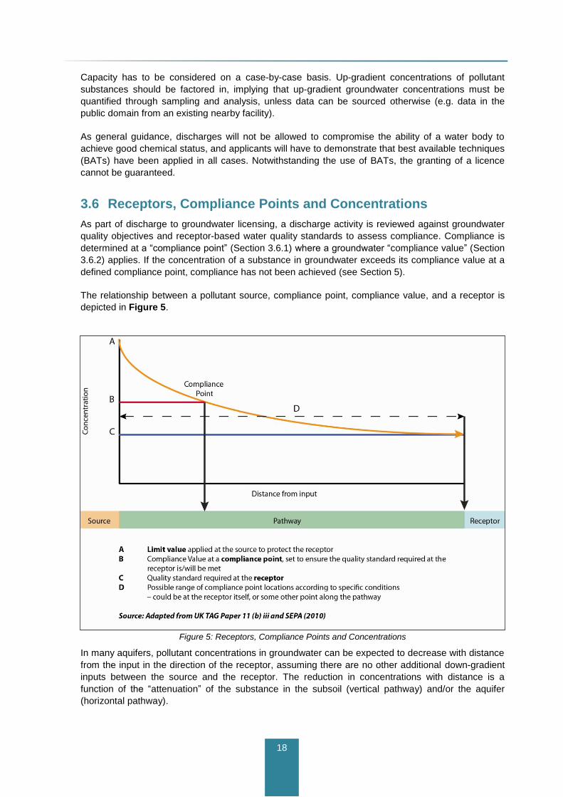
18
Capacity has to be considered on a case-by-case basis. Up-gradient concentrations of pollutant
substances should be factored in, implying that up-gradient groundwater concentrations must be
quantified through sampling and analysis, unless data can be sourced otherwise (e.g. data in the
public domain from an existing nearby facility).
As general guidance, discharges will not be allowed to compromise the ability of a water body to
achieve good chemical status, and applicants will have to demonstrate that best available techniques
(BATs) have been applied in all cases. Notwithstanding the use of BATs, the granting of a licence
cannot be guaranteed.
3.6 Receptors, Compliance Points and Concentrations
As part of discharge to groundwater licensing, a discharge activity is reviewed against groundwater
quality objectives and receptor-based water quality standards to assess compliance. Compliance is
determined at a “compliance point” (Section 3.6.1) where a groundwater “compliance value” (Section
3.6.2) applies. If the concentration of a substance in groundwater exceeds its compliance value at a
defined compliance point, compliance has not been achieved (see Section 5).
The relationship between a pollutant source, compliance point, compliance value, and a receptor is
depicted in Figure 5.
Figure 5: Receptors, Compliance Points and Concentrations
In many aquifers, pollutant concentrations in groundwater can be expected to decrease with distance
from the input in the direction of the receptor, assuming there are no other additional down-gradient
inputs between the source and the receptor. The reduction in concentrations with distance is a
function of the “attenuation” of the substance in the subsoil (vertical pathway) and/or the aquifer
(horizontal pathway).

19
Attenuation is the generic term used to describe the decrease in pollutant concentrations, flux, or
toxicity that may take place in the subsurface environment. It results from one or more of the
following physical, chemical and/or biological processes: dilution, dispersion, filtration, sorption,
decay, transformation, biodegradation, ion exchange, and retardation. The processes of decay and
transformation (especially) can also result in the reduction of concentrations with time.
Attenuation processes differ in nature and scale both as a function of site hydrogeology and the
chemical nature of the pollutants in question, and therefore influence what compliance values are set,
how compliance monitoring is carried out, and how results are interpreted (see Section 5).
Attenuation processes are further described in Appendix D.
3.6.1 Compliance Point
From Figure 5, the compliance point is most often located at an intermediate point between the
source and the receptor. If the compliance value is exceeded at the compliance point, the relevant
water quality standard at the receptor is also likely to be exceeded.
The compliance point represents a groundwater sampling location (e.g. a monitoring well) from which
representative groundwater samples can be obtained. Representative samples reflect the highest
groundwater flux and concentration of a given substance at a given location.
The selection of compliance points is influenced by the type of receptors and pollutants that are
involved (notably whether they are classified as hazardous or non-hazardous). Details on the
selection of compliance points are provided in Section 5.
3.6.2 Compliance Value
The compliance value is the concentration of a substance at a compliance point that will achieve
water quality standards at a receptor. A compliance value may be in the form of a concentration (limit
value) at the source or at the receptor itself.
The compliance value is most often defined by the type of receptor. For example, if the principal
receptor is a river, the EQSs for surface waters (see Appendix C) would apply. In this case, a
compliance value in groundwater (if applicable to a case-specific setting) would be the concentration
in groundwater that does not result in the EQS being exceeded, after mixing (dilution) between
groundwater and the river (see Appendix E).
As the compliance value is most often linked to the standard at a receptor, the compliance value
should be defined by the same statistical basis as the standard. For example, if the applicable
standard is a mean annual concentration, the compliance value would also represent a mean annual
concentration.
Where the receptor is the groundwater resource (aquifer), the compliance value would, in most Irish
bedrock aquifers, be defined by the appropriate groundwater quality standard as described in Section
3.4. This is because attenuation processes in bedrock aquifers are mostly limited to mixing and
dilution in groundwater beneath the source (see Appendix D), with limited further attenuation
expected in a down-gradient flow direction. In sand and gravel aquifers, however, attenuation
processes such as dispersion, sorption and biodegradation can be more significant. In such cases,
the compliance value could be set as a higher concentration than the quality standard for the
receptor, provided that the compliance point is located within the site/property boundary in question
(so as not to restrict potential offsite use by others), and other receptor-based standards are not
exceeded.
Furthermore, any review of a discharge to groundwater activity should take account of up-gradient
concentrations, as described in Section 3.6.4.

20
3.6.3 Compliance and Multiple Receptors
Where multiple receptors are present, the appropriate water quality standard should be chosen for
each potential receptor. Where possible, the compliance value should be derived at a common
compliance point as shown in Figure 6. The most stringent water quality standard would be selected
for each substance, although this should be judged on a case-by-case basis.
Figure 6: Compliance Monitoring for Multiple Receptors
3.6.4 Consideration of Background and Up-gradient Concentrations
Compliance monitoring should take into consideration data or information on background and/or up-
gradient concentrations in groundwater.
In certain aquifers, background concentrations of some substances might be naturally elevated, in
which case these can be used as compliance values for the substances in question. A useful
reference on natural background concentrations for different aquifer types in Ireland is “Establishing
Natural Background Levels for Groundwater in Ireland” (Baker et al., 2007).
In other cases, the possibility exists that groundwater flowing into a site is already impacted by an up-
gradient source of pollution. In this case, the “capacity” of the aquifer at the site will be reduced,
whereby the allowable load (input) to the aquifer from the planned or proposed discharge activity is
also reduced.
Information on background concentrations may be available and should be researched from entities
such as the EPA (e.g. IPPC licences), GSI (groundwater section), local authorities, or industry (e.g.
identified from walkover surveys).
Where up-gradient concentrations are elevated, the associated cause should be established, which
includes examining the potential role of diffuse pressures. Where up-gradient data are not available,
such data may have to be established from sampling as part of a site assessment (see Section 4).
21
As general guidance, new inputs will not be allowed to compromise the ability of a receiving water
body or ecosystem to achieve good status (as defined by the Groundwater Regulations), nor cause
any deterioration in existing status of the water body. For this reason, the likely impacts from new
inputs must be predicted and verified (see Sections 4 and 5).
3.7 Cumulative Impacts
Cumulative impacts result when the effects of one activity are added to or interact with the effects of
other activities within a geographical area and within a particular time. While a single discharge
activity may not be of particular concern, the cumulative impact of many discharge activities in a
small area may result in impact to groundwater quality and non-compliance with water quality
objectives and standards.
The obvious area of concern with regard to discharges to groundwater relates to potential impacts
from OSWTSs, especially those associated with new housing and leisure developments close to
nutrient-sensitive receptors such as streams and GWDTEs.
The main concern with the proliferation of OSWTSs is the inappropriate construction of such systems
in areas that are not suited for effluent disposal, such as:
Areas of low permeability subsoil where infiltration capacity is naturally limited;
Areas where underlying aquifers do not have sufficient ability to “accept” and move the
effluent away from the site; and
Areas of extreme groundwater vulnerability where subsoils are thin or absent and therefore
cannot provide adequate pollutant attenuation.
The first two cases may result in ponding of effluent and enhanced runoff to surface receptors without
adequate attenuation of pollutants. The third case may result in enhanced loading and/or direct
discharges to groundwater and therefore also result in inadequate attenuation.
Individually, OSWTSs are potential point sources of pollution. Collectively, clusters of OSWTSs can
impact wider areas. OSWTSs primarily contribute nitrogen to groundwater but in certain
hydrogeological settings (e.g. shallow, free draining sandy soils), they can also contribute
significantly to phosphorus loading, particularly in the longer term when the soils capacity to absorb
phosphorus has been exhausted. As such, inputs from clusters of OSWTSs can be of concern to
groundwater quality both locally and at the groundwater body scale.
Effluent from OSWTSs is also a potential source of pollution to wells, particularly domestic wells. As
reported by Spain and Glasgow (2009), there are over 400,000 systems in Ireland discharging
approximately more than 80 million cubic metres of effluent into the ground annually.
As described in the code of practice (CoP) for OSWTSs (EPA, 2009a), a potential limiting factor for
the siting of a treatment system is the existing concentrations of nitrates (and in some cases,
phosphates) in the groundwater. If the nitrate concentration in a particular area is elevated (e.g. due
to the spreading of fertilizers and/or a high density of existing OSWTSs in that area), then the local
authority may seek additional information (including dilution calculations) to assess any potential
impact on the groundwater quality from new, proposed developments. Annex D.2 of the referenced
CoP provides details on dilution calculations (see also worked examples in Appendix E in this
guidance document).
In theory, the assessment of cumulative impact is not substantially different from the assessment of
impact from a single activity, except the technical scope and geographic study area may be broader

22
and larger, and the cumulative impact assessment would entail a more extensive review of possible
effects.
There is no specific applicable threshold (e.g. density of OSWTSs) that triggers a cumulative impact
assessment. However, the Environmental Impact Assessment Directive (85/337/EEC, as amended
by Directive 97/11/EC) requires the “competent/consent authority” to decide whether or not a
cumulative impact assessment should be carried out, on a case-by-case basis.

23
4 Technical Assessment Approach and
Methodology
The recommended assessment approach and methodology is shaped by the key questions asked in
Section 3.3. This includes screening the risk to groundwater from a proposed discharge activity,
determining the level of technical assessment that may be required, predicting a likely impact on
groundwater quality and receptors, and if needed, subsequently verifying the predicted impact.
The methodology is based on the SPR model, whereby a source and a receptor are linked by one or
more pathways.
The methodology is primarily aimed at:
1. Demonstrating that a site has sufficient infiltration capacity to avoid problems with surface
ponding of effluent;
2. Estimating the chemical loading and attenuation that can be expected in the subsurface
environment; and
3. Where necessary, verifying predicted impacts on groundwater quality by checking
compliance with relevant groundwater quality objectives and standards.
To demonstrate hydraulic suitability and estimate loading and attenuation, a series of technical steps
are followed, described below, which result in a risk-based determination of whether or not a
discharge activity can be authorised, or if further assessment of the activity is needed, involving field
work and more detailed study.
Crucially, the level of assessment required should be proportionate to the risk posed. As the technical
assessment involves different degrees of complexity and potential uncertainty, decisions about
authorisation will likely involve professional judgement and therefore a “weight of evidence”
approach.
In general, it is not appropriate to discharge to groundwater in the following circumstances:
where the site is hydraulically unsuitable and has insufficient infiltration capacity (i.e. greater
likelihood of ponding and surface runoff); and
where analysis of a source indicates that chemical loading to groundwater and subsequent
mixing (dilution) in the underlying aquifer will result in a groundwater quality impact, both in
relation to compliance values and groundwater quality objectives.
Such cases may not allow for authorisation to be granted, or may place a case in a higher-risk
category, which requires more detailed technical assessment.
4.1 SPR Risk Factors
SPR risk factors must be researched, reviewed, and quantified through desk study and field work.
Primary SPR risk factors are:

24
Location, type and nature of the source (discharge effluent);
Vertical and horizontal pathways in the subsurface; and
Presence/absence of nearby sensitive receptors.
Risk is primarily defined in terms of:
Hydraulic capacity to percolate/infiltrate the proposed quantities of effluent;
Ability of the aquifer to transmit the percolated effluent away from the site; and
Potential impact on groundwater quality and nearby receptors.
Low risk scenarios are those where unacceptable impacts in relation to groundwater quality
objectives are not likely to occur. They tend to be identified where:
The effluent (e.g. tertiary treated waste water effluent) has concentrations of non-hazardous
pollutants within the relevant water quality standard(s) associated with the most sensitive
receptor;
Groundwater vulnerability is low to moderate (i.e. substantial vertical travel times to the
groundwater receptor);
The discharge is located far from receptors such as rivers, wetlands, and abstraction points
(and not within their estimated zones of contributions);
Sufficient dilution of the effluent would take place such that the loading and concentrations in
groundwater would not result in an upward concentration trend, deterioration of groundwater
chemical status, or breach of the prevent or limit objective; and
The site is hydraulically suitable for effluent percolation – a low vulnerability setting, which is
favourable with respect to low risk of impact, may not be hydraulically suited for infiltration.
Higher risk groundwater scenarios are those where an impact can be or is expected to occur. They
tend to be identified by cases where:
Hazardous substances are present in the source (e.g. landfills);
The site may not be suitable for effluent percolation;
The effluent has concentrations of non-hazardous pollutants higher than the relevant
receptor based water quality standard;
Groundwater vulnerability is high to extreme (i.e. short vertical travel times to the
groundwater receptor), especially where the underlying aquifer is a karstified limestone
aquifer (i.e. with rapid horizontal travel times). Where groundwater vulnerability mapping has
not yet been completed by the GSI, a higher risk has to be assumed by default, and site
investigation will be needed to establish site-specific vulnerability;
The discharge is located close to sensitive receptors such as streams with a low summer
flow, GWDTEs, and groundwater abstraction points (and within their estimated zones of
contribution or source protection zones); and

25
There is likely to be insufficient dilution of the effluent such that the loading and
concentrations in groundwater could result in an upward concentration trend, deterioration of
groundwater chemical status, or breach of the prevent or limit objective.
Moderate risk scenarios fall between the low and high risk categories defined above. Assignment of
risk is subject to some degree of professional judgement.
In many cases, risk may be reduced or managed through appropriate control measures at the source
(e.g. improved pre-treatment of the effluent).
4.2 Assessment Methodology
The technical assessment methodology includes three steps, as follows:
1. Determining the type and nature of the discharge activity;
2. Carrying out a risk screening to judge the degree of risk posed by the discharge activity on
groundwater quality and receptors; and then,
3. From the risk screening, determining an appropriate level of technical assessment that is
needed to address questions about site suitability and estimation of loading and attenuation.
4.2.1 Step 1 – Determining the Type and Nature of the Discharge Activity
The first step simply involves answering a few basic questions about the type and nature of the
discharge activity:
Location: the discharge activity should be located away from features defined by the
minimum separation distances recommended in earlier guidance documents and codes of
practice relating to OSWTS and ICWs, reproduced in Appendix F. If the proposed
discharge is located within these minimum separation distances, authorization would not be
granted.
Volume (quantities of effluent): this should be defined in terms of average and maximum
discharge rates (m3/d or other defined units), with a description of seasons, time periods
and/or durations when maximum discharge rates apply.
Method and means of the proposed effluent disposal (direct or indirect);
Layout and total area of the proposed effluent disposal/percolation.
Chemical composition and concentrations of individual substances in the effluent: this should be
specified in terms of minimum, average and maximum concentrations, and where possible, an
indication of time periods and/or durations when maximum concentrations are expected.
Determining whether the discharge effluent may contain hazardous substances; and
Determining whether the discharge activity can be exempted from technical assessment (see
Section 2.5).

26
4.2.2 Step 2 – Risk Screening of Potential Impact to Groundwater and
Receptors
The second step involves risk screening for potential impact from a review and interpretation of the
principal SPR risk factors. The outcome of the risk screening is therefore an initial determination of
risk (low, moderate, high).
Figure 7 illustrates the risk screening process for proposed or planned discharge activities. The
principal risk factors to be considered are:
Type and nature of the discharge activity (see Section 4.2.1);
Pathways – groundwater vulnerability and aquifer type;
Minimum separation distances from features of interest (see Appendix F);
Presence of, and proximity to, potential receptors; and
Presence of, and proximity to, other features of interest, such as special areas of
conservation and zones of contribution to existing abstraction points or schemes.
Table 2 summarises the specific information to be considered and reviewed during risk screening.
The applicant provides the basic data and information related to the principal SPR risk factors. The
data and information can be sourced, checked, and reviewed from the sources of information
outlined in Appendix B.
Information on receptors and special features of interest will involve review of maps, site walkover
surveys, and possibly consultations with the NPWS and other relevant public bodies (e.g. local
authorities). As the risk screening involves preliminary hydrogeological review and analysis, the
screening should be carried out by a suitably qualified person (see Section 4.4).
Importantly, the risk screening process involves placing SPR information into an appropriate and site-
specific hydrogeological context, as hydrogeological factors dictate the risk of impact. The initial risk
screening should therefore include the development of a conceptual hydrogeological model of the
site.
A conceptual hydrogeological model represents a simplified description of a real hydrogeological
system. A good conceptual model helps to develop an appropriate understanding of the
hydrogeology of a site and, therefore, how pollutants will migrate and attenuate. Moreover, it helps to
define an appropriate and representative monitoring network, where appropriate, so that impacts can
be adequately identified and quantified. Conceptual model development in the context of Irish
hydrogeology is included in Appendix G.
4.2.2.1 Existing Inputs
Whereas Figure 7 applies to new proposed or planned inputs to groundwater, Figure 8 shows a
proposed review process for existing inputs. Under Regulation 12 of the Groundwater Regulations,
existing inputs have to be retrospectively reviewed to determine if they have regard for the
requirements of the key objectives of the Groundwater Regulations. Existing authorisations are
required to be examined and reviewed, or if a review is not considered necessary, a written
declaration must be issued, by relevant public authorities, including the EPA, by 22nd
December
2012.
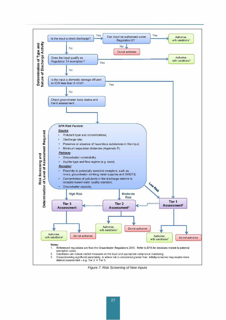
27
Figure 7: Risk Screening of New Inputs

28
Table 2: Summary of Data and Information to be Considered During Risk Screening
Key Component Main Consideration Requirement Primary Data Source
Source
Volume/rate Quantity of effluent Volume/rate of effluent Specified by applicant
Chemical and bacteriological composition
Chemical and
bacteriological
composition of the effluent
Chemical and bacteriological composition and
concentrations of individual substances Specified by applicant
Potential pollution sources in area Impact on groundwater
quality
Locations, types, licenses (includes waste water
treatment plants and other discharge to
groundwater locations for waste water effluent).
EPA, local authority, walkover survey
Pathway
Groundwater vulnerability Vertical pathway Groundwater vulnerability category;
Subsoil permeability GSI maps
Aquifer type and characteristics Horizontal pathway Aquifer type;
Flow regime (e.g. karst).
GSI maps;
GSI description of groundwater bodies
Receptor
Groundwater body chemical status and
trends Capacity
Groundwater quality data, surface water quality
and ecological data, ecological assessments
EPA – chemical status classification, groundwater
and surface water data;
Groundwater Resource/Aquifer Current and future value Type, extent, use, recharge, groundwater quality
beneath site
GSI maps;
GSI description of groundwater bodies;
EPA and GSI – groundwater protection schemes,
zones of contribution;
EPA and local authority groundwater quality data.
Groundwater abstraction and/or discharge
points (e.g. springs), and their related
source protection zones
Locations and boundaries Location, zones of contribution and SPZ reports
GSI, EPA, local authority maps and databases of
abstractions and groundwater protection
schemes, zones of contribution, walkover surveys.
Surface water body Protection Location, type, environmental sensitivity, status
classification
Walkover surveys, EPA maps, interim status
classification, and data;
Legislation: EQS, Bathing waters, Salmonid,
Shellfish Waters.
GWDTE Protection Types, boundaries, designations of qualifying
interests and environmental sensitivity
Walkover surveys, NPWS maps, reports and
consultation
Other protected areas
Special Areas of
Conservation; Natural
Heritage Areas;
Special Protection Areas
Boundaries, designations, conservation
significance, characterisation information NPWS maps and reports

29
Figure 8: Proposed Review Process of Existing Inputs

30
For historical inputs (e.g. contaminated land or accidents/spills/losses) where pollutants, including
hazardous substances, are known to have already entered groundwater and are causing pollution to
a receptor, the examination and review process will determine the need for, and scope of,
remediation that is appropriate for the situation, while considering technical feasibility and costs.
Where impacts are not known, site investigation and sampling work may be needed to verify whether
or not impact to groundwater has occurred. If impact has not occurred, and the risk of future impact is
deemed to be low, no further assessment may be required. If, however, impact is verified or is of a
high-risk nature, further assessment is likely to be needed.
4.2.3 Step 3 – Determining an Appropriate Level of Technical Assessment
From the risk screening, different levels of technical assessment may be required, as follows:
Where risk is deemed to be negligible or low, a Tier 1 assessment is required (see Section
4.3.1);
Where risk is deemed to be moderate, a Tier 2 assessment is required (see Section 4.3.2);
Where hazardous substances may be involved and/or risk is otherwise deemed to be high, a
Tier 3 assessment is required (see Section 4.3.3).
Table 3 summarises the recommended tiers of technical assessment for different examples of input
types and risk factors. A general discussion of input types and justification for considering different
thresholds of effluent quantities is included in Appendix D.
4.3 Tiers of Assessment
Technical assessment must demonstrate site suitability with regards to two key elements:
An ability to infiltrate (percolate) the planned or projected quantities of effluent without
causing surface ponding; and
Adequate attenuation potential so that groundwater quality objectives and standards are
likely to be met.
The ability to infiltrate (percolate) effluent is a function of both subsoil and aquifer characteristics. If
subsoil permeability is low (i.e. clay-rich) the site may not be suitable for long-term infiltration of
effluent, resulting in surface ponding. Similarly, if subsoil permeability is high but the underlying
aquifer permeability is low and the site is relatively flat, water may not readily flow away from the site,
resulting in potential ponding.
The attenuation potential of a site is determined by many factors, but subsoil thickness and the
relative permeabilities of both subsoils and aquifer materials are key factors. The attenuation
potential will be greater where subsoils are thick and relatively permeable. In contrast, a reduced
attenuation potential will exist where subsoils are thin.

31
Table 3: Recommended Tiers of Assessment
Examples of Input Types
[1]
Threshold Description Risk of Impact
[2]
Recommended Tier of Assessment
Examples of Risk Factors
Hazardous
All n/a All effluents involving a hazardous substance
High [3]
n/a Input to groundwater not permitted.
Non-Hazardous
Domestic waste water effluent
Less than or equal to 5 m
3/d
Septic tanks, infiltration areas Low Tier 1 [4]
Site not suitable for percolation[5]
– e.g. low-permeability subsoil, high groundwater table, underlying aquifer will not allow sufficient effluent migration away from site, resulting in ponding.
Inadequate attenuation potential[5]
– thin or absent subsoils, low degree of mixing/dilution in groundwater.
Minimum separation distances from features of interest– see Appendix F
[5].
Greater than 5 and less than 20 m
3/d
Small housing developments, hotels, leisure facilities
Moderate Tier 2
High chemical load (nutrients).
Areas of “High-to-Low” groundwater vulnerability (i.e. area not yet mapped in detail by the GSI).
SPZ, ZOC, or GWDTE located within 1 km of discharge.
High Tier 3
High or extreme groundwater vulnerability.
High volume and chemical load (nutrients).
Karst presence [5]
, especially where vulnerability is extreme.
Poor (chemical) status groundwater body.
Greater than 20 m
3/d
Large-scale developments and WWTPs.
High Tier 3
High or extreme groundwater vulnerability.
Areas of “High-to-Low” groundwater vulnerability (i.e. area not yet mapped in detail by the GSI).
High volume and chemical (nutrient) load.
Sensitive receptors and features such as SPZs, ZOCs, or SACs within potential groundwater flow path, irrespective of distance from discharge location.
Poor (chemical) status groundwater body.
Integrated
constructed
wetland (ICWs) [6]
Less than or equal to 5 m
3/d
Infiltration from ponds Low Tier 1 See domestic waste water effluent, less than or equal to
5 m3/d.
Greater than 20 m
3/d
Infiltration from ponds
Moderate Tier 2 See domestic waste water effluent, greater than 5 and
less than or equal to 20 m3/d.
High Tier 3 See domestic waste water effluent, greater than 20 m
3/d –
high risk.

32
Examples of Input Types
[1]
Threshold Description Risk of Impact
[2]
Recommended Tier of Assessment
Examples of Risk Factors
Non-Hazardous cont.
Trade effluent n/a
Discharges from premises used for any trade or industry, and not including domestic waste water or storm water.
Moderate Tier 2
High groundwater vulnerability.
Industrial-type pollutants.
High chemical load.
SPZ, ZOC, or GWDTE located within 1 km of discharge.
High Tier 3
High to extreme groundwater vulnerability.
High volume and chemical load.
Sensitive receptors and features such as SPZs, ZOCs, or SACs within potential groundwater flow path, irrespective of distance from discharge location.
Poor (chemical) status groundwater body.
Landfill n/a Leachates High[7]
Tier 3 Assessment subject to requirements of existing
regulations and EPA guidance.
Sustainable Urban Drainage Schemes (SuDS)
n/a Urban stormwater
Low Tier 1 [4]
Low chemical load.
High Tier 3
High to extreme groundwater vulnerability.
Discharge directly to bedrock aquifer.
High chemical load.
Inadequate attenuation potential.
Quarries n/a
Process water, including discharge from settlement ponds, and accidental (oil) spills
Low Tier 1 [4]
Considered low risk due to general absence of chemicals
from process water.
Note:
1 – see Appendix D for discussion on different input types.
2 – determined from risk screening of an individual input.
3 – inputs of hazardous substances to groundwater are not permitted under the prevent objective, hence cases involving hazardous substances are deemed high risk by default.
4 – Tier 2 assessment may be required if site is not hydraulically suitable or if attenuation potential of site is deemed to be potentially insufficient.
5 – applies to all input types. Engineering measures may be considered to improve attenuation potential (as long as it can be demonstrated that the site is otherwise hydraulically suitable).
6 – primarily applies to nutrient loading from domestic waste water and farmyard soiled water – for other applications, effluent must be characterised in terms of the potential presence of hazardous
substances. 7 – by default.
33
Table 4 summarises the main technical considerations and testing requirements that may be
required for the three different tiers of assessment. As a principle, the technical detail of assessment
is proportional to the type, size and complexity of the discharge activity and site hydrogeology, as
well as proximity to receptors and important hydrogeological features. The main differences between
the tiers of assessment relate to the scope of site investigation and extent of field testing that may be
required, as well as the degree of monitoring that may be required.
4.3.1 Tier 1 Assessment
Tier 1 assessments generally cover these low-risk activities:
Inputs less than 5 m3/d of domestic waste water (mainly associated with OSWTSs);
Small SuDS in low risk settings; and
Discharge of quarry process water (which is collected in engineered holding ponds).
A typical Tier 1 assessment should follow the site characterisation procedures described in the EPA
CoP for waste water treatment disposal systems for single houses (EPA, 2009a). The associated site
characterisation form in Appendix C of the CoP sets out the steps to be taken for site suitability
testing and other information that needs to be considered or defined as part of the site assessment.
Every trial hole and other subsoil exposure should be used to describe subsoil type and texture.
Applications for small SUDS developments should follow the same approach. Where the quarry
process water has a lower pollutant loading than an OSWTS, a simpler procedure may be adequate.
The EPA CoP is designed to demonstrate site suitability. If a Tier 1 assessment cannot demonstrate
site suitability, authorisation may not be granted. Conversely, provided the site characterisation form
that accompanies the EPA CoP is completed, and the infiltration (percolation) tests are passed,
authorisation may be granted. The authorisation would be subject to best practice with regard to
proper operation and maintenance of any OSWTS, as directed by the DEHLG circular on
performance of OSWTSs (dated 19 October 2010). If there is uncertainty about results, further site
investigation may be needed, akin to the Tier 2 assessment described in Section 4.3.2.
There are hydrogeological scenarios where site suitability is questionable from the outset, and where
special engineering measures may be needed, either to improve the infiltration capacity and/or
attenuation potential of the site.
For example, where the water table is high (within 1 m of ground surface), the ground may not accept
the new discharge, resulting in ponding and increased surface runoff with reduced attenuation
potential (Daly, 2006; EPA 2009a). In this case, engineering measures as outlined in the EPA CoP
may be required.
Disposal of effluent directly into a bedrock aquifer is not regarded as acceptable, as pollutants would
enter a bedrock aquifer with little or no attenuation potential in subsoils, thereby increasing the risk of
impact to groundwater quality. A direct effluent discharge to bedrock will occur where subsoils are
thin or absent. In such cases, special engineering considerations such as the construction of a
mound may be needed. Measures to improve treatment should also be considered.
For hydrogeological settings where the subsoil is thin and the planned discharges would take place
directly over poorly productive bedrock aquifers (see Appendix G), the permeability of the bedrock
and winter (wet season) groundwater tables may have to be considered to ensure that percolation of
the planned discharge is physically possible (Daly, 2006). Poorly productive bedrock aquifers may
have a limited ability to “accept” all of the effluent that is discharged, which could give rise to
mounding of water levels and ponding of effluent at the surface in the long-term.

34
Table 4: Examples of Potential Site Investigation Requirements for Different Tiers of Assessment
Level of Assessment
Main Considerations Examples of Site Investigation Requirements
Reference Documents
Tier 1
Infiltration capacity.
Chemical and bacteriological composition of input.
Minimum separation distances (Appendix F).
Simple conceptual model (graphic and/or description) by the assessor.
Infiltration (percolation) testing; Chemical and bacteriological composition of input;
Trial hole excavations.
EPA Code of Practice: Waste water Treatment and Disposal Systems serving Single Houses (p.e. <10) – notably Appendix C (2009).
ICW Guidance (DEHLG, 2010).
GSI and EPA maps
Tier 2
(Additional to Tier 1)
Groundwater flow direction (inferred from topography).
Subsoil type, texture, thickness and permeability.
Aquifer type and hydraulic properties.
Background groundwater quality.
Identification of relevant receptors and associated water quality standards.
ZOCs of downgradient abstraction points/schemes where these have not yet been delineated.
Conceptual model described in report and usually including cross-sections or block diagrams.
(Additional to Tier 1)
Subsoil and bedrock characterisation through drilling and sampling – e.g. type, variability, weathering, structure.
Grain size analysis for subsoil permeability.
Bedrock permeability testing (rising/falling head tests).
Piezometer and/or monitoring well construction.
Groundwater sampling and water level measurement.
EPA Waste water Treatment Manuals – Treatment Systems for Small Communities, Business, Leisure Centres and Hotels.
British Standards Code of Practice for Site Investigations BS5930.
IGI Guidelines on Water Well Construction.
ICW Guidance (DEHLG, 2010).
Tier 3
(Additional to Tier 1 and 2)
Groundwater flow direction and gradients (from site-specific measurement and monitoring).
Quantification of interaction between groundwater and surface water or GWDTE (where appropriate and relevant).
Detailed conceptual model, with cross-sections or block diagrams and, where appropriate, numerical modeling.
(Additional to Tier 2)
More detailed subsoil and bedrock characterisation (see Section 4.3.3).
Subsoil permeability from rising/falling head tests.
Where appropriate, permeability testing of clays using laboratory methods.
Surface geophysical surveys (e.g. depth to bedrock mapping).
Aquifer test pumping.
Where appropriate, detailed hydrological monitoring, including streamflow measurements.
(Additional to Tier 2)
Landfill Manual - Guidance Note on Investigations for Landfills (EPA, 1995).
Landfill Manual - Guidance note of Landfill Monitoring (EPA, 2003).
BAT Guidance Note - Waste Sector (Landfill) - April 2003.
35
Where groundwater abstraction points, notably public water supplies and group water schemes, are
located within 100 m of the planned discharge activity, it is advisable to take account of potential
impacts on the drinking water sources in the assessment.
4.3.2 Tier 2 Assessment
Tier 2 assessments generally cover the following moderate risk activities:
Inputs greater than 5 m3/d and less than or equal to 20 m
3/d of domestic waste water
associated with OSWTS and ICWs; and
Trade effluent where risk screening indicates a moderate risk of impact.
Tier 2 assessments also cover any discharge activities where an initial Tier 1 assessment indicates
significant uncertainty or demonstrates a higher risk of impact compared to the initial risk screening.
Decisions in such cases are made on a site-by-site basis.
4.3.2.1 Infiltration Capacity and Testing
For Tier 2 assessments, infiltration capacity is estimated from trial hole tests (as referenced in Section
4.3.1) and from calculations using subsoil permeability values derived from subsoil characterisation
(see Appendix E).
Subsoil permeability is a key parameter in estimating and demonstrating the infiltration (percolation)
capacity of a site, and takes on an increased importance as discharge volumes become larger. It can
be estimated in different ways. Estimates can be made in several ways: from subsoil texture
descriptions, grain size analyses, slug or pumping tests in boreholes, and from laboratory permeability
analysis of subsoil samples. For Tier 2 assessment, rough estimation will be adequate in most cases.
The subsoil characterisation should include a description of lateral and vertical heterogeneity,
including the presence of clay layers, even if these are thin. Thin clay layers can critically impede
vertical infiltration of water/effluent. If laterally continuous, even thin bands no more than 10–20 cm
thick can affect infiltration capacity.
Procedures for calculating infiltration capacity on the basis of subsoil permeability are provided in
Appendix E.
If the site is not deemed hydraulically suitable, authorisation should not be granted unless engineered
control measures such as those presented in the EPA CoP can be taken to facilitate infiltration, in
which case these have to be designed, constructed and further tested.
In many cases, engineering solutions may be found to enhance infiltration capacity through subsoil.
However, infiltration capacity is also a function of the ability of the underlying aquifer to transmit
percolated effluent away from the site. As such, the assessment of infiltration capacity also has to
take account of the type, nature and permeability of the underlying aquifer, which is the subject of the
groundwater characterisation of the site (see below).
4.3.2.2 Subsoil Characterisation
A Tier 2 assessment requires a more detailed characterisation of the subsoil, usually of the total depth
down to bedrock. To establish depth to bedrock (i.e. subsoil thickness), the drilling of boreholes may
be necessary, especially where the depth to bedrock is beyond the safe limit of trial holes or pits.
36
Trial holes are favoured where they can be excavated safely, as they expose a larger area of subsoil
and provide a clearer image of subsoil characteristics. However, they can rarely (safely) achieve more
than 3 m depth without special design and safety considerations.
Useful guides to subsoil permeability estimation from field tests can be found in Fitzsimons, et al.
(2003) and Swartz et al. (2003).
Where boreholes are drilled, subsoil samples should be collected every metre of depth and at each
change of subsoil type. A reasonable number of samples for particle size distribution should be
collected, from which subsoil permeability can be estimated.
The subsoil characterisation should also verify the depth of a groundwater table (including any
perched water tables above a bedrock aquifer). Groundwater levels in trial pits and boreholes should
be noted as a measurement from the ground surface or other common reference point.
4.3.2.3 Groundwater Characterisation
Groundwater characterisation is necessary to enable a prediction of impact to groundwater quality
beneath a site (see Section 5) and the subsequent migration and attenuation of pollutants in
groundwater away from the site.
The Tier 2 assessment involves:
Establishing a likely groundwater flow direction – this places the site in the context of potential
receptors that are situated hydraulically down-gradient of the site;
Verifying aquifer type;
Estimating the hydraulic properties (notably hydraulic conductivity, or permeability) of the
aquifer; and
Establishing the existing groundwater quality, both up-gradient from, and at the site of, the
planned discharge location.
The flow direction, aquifer type, and hydraulic conductivity are fundamental to: a) examining the
natural groundwater flux through the aquifer; and b) evaluating whether the aquifer has the hydraulic
ability to transmit the percolating effluent away from the site (without causing excessive mounding
and/or ponding of effluent at the surface).
In many, if not most circumstances, groundwater flow directions can be inferred from a reading of
topography under the assumptions that: a) the groundwater table is a subdued reflection of
topography; and b) groundwater flows from higher elevations to lower elevations, eventually
discharging into surface waters.
Although topography is a good first indicator of flow direction, there are exceptions where:
The bedrock aquifer is a karstified limestone;
The aquifer is highly permeable; and
Groundwater levels at a site are influenced by groundwater abstraction(s) at a nearby
location.
Karstified limestone aquifers require special consideration with regards to hydrogeological
characterisation as groundwater flow patterns can be unpredictable (see Appendix G).

37
With regard to the influence from pumping, the potential presence of existing groundwater abstraction
schemes in the vicinity of a site should be researched and identified during risk screening. Where
groundwater abstraction points, notably public water supplies and group schemes, are located within
1 km of the planned discharge activity, the ZOC of the abstraction point should be defined. The ZOC
may already be defined as part of a groundwater protection scheme or source protection zone report
(available through the local authority, the EPA, or the GSI). If not, the ZOC should be delineated using
a water balance approach using a similar methodology to that adopted for the EPA’s ZOC delineation
tool.
Describing and establishing the nature of the aquifer involves drilling and lithological description,
noting important features such as bedrock material, degree of weathering and fracturing, water
strikes, and rock structure.
Estimates of hydraulic properties, notably hydraulic conductivity (or permeability), would be derived
from hydraulic testing of boreholes and/or monitoring wells. Pumping tests are preferred over any
other method of hydraulic testing in bedrock, but for Tier 2 assessment, falling or rising head tests
(slug tests) are deemed sufficient, provided these are properly carried out and analysed (and their
limitations acknowledged).
Data and information on aquifer properties from other nearby studies can and should be used where
such information is available and can be obtained (e.g. from local authorities and the GSI).
In poorly productive aquifers (see Appendix G), pumping tests may or may not be feasible or
meaningful. Where pumping tests are not meaningful, rising or falling head tests should be carried out
in boreholes (e.g. during drilling) and/or in monitoring wells following well construction and
development.
The number of boreholes and wells that should be drilled and tested cannot be prescribed and is a
function of the size of the discharge activity and the conceptual hydrogeological model of the site.
This involves professional judgement, and Tier 2 investigations must therefore be carried out by a
suitably qualified person.
Establishing the existing groundwater quality requires the sampling of pumping or monitoring well(s)
that are open or screened in the aquifer that is at risk from being impacted. This will require the drilling
and construction of new wells (i.e. same wells used for hydraulic testing). The determination of well
depths and where wells should be open or screened is a function of site-specific hydrogeology and
the conceptual model of pathways and groundwater fluxes (see Appendix G).
The chemical analysis of water samples should be targeted at the key substances of concern (e.g.
nitrate), and depends on the discharge type and the chemical composition of the effluent (see
Appendix D).
If reliable and relevant groundwater quality data are available from existing wells at nearby sites or
locations (e.g. existing EPA monitoring network), such data may be used, provided: a) the data are
from the same aquifer that the discharge activity may impact; and b) the data have been obtained
from accredited analytical laboratories. Whether or not this is appropriate for a particular situation
involves professional judgement by a suitably qualified person.
4.3.2.4 Prediction of Impact to Groundwater Quality and Receptors
Following the prior site investigation, the potential impact to groundwater quality and receptors
involves a series of calculations which are summarised in Figure 9, and which are detailed with
examples in Appendix E.
Using data that are derived primarily from site investigations, the calculations involve:
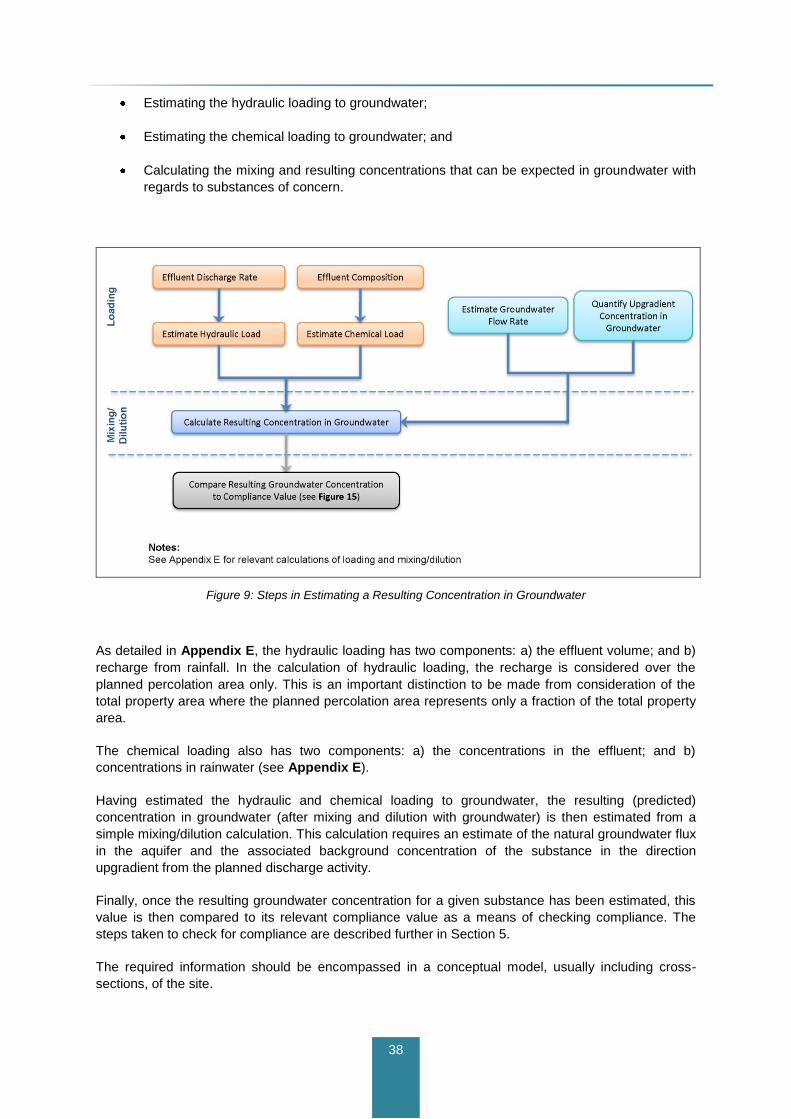
38
Estimating the hydraulic loading to groundwater;
Estimating the chemical loading to groundwater; and
Calculating the mixing and resulting concentrations that can be expected in groundwater with
regards to substances of concern.
Figure 9: Steps in Estimating a Resulting Concentration in Groundwater
As detailed in Appendix E, the hydraulic loading has two components: a) the effluent volume; and b)
recharge from rainfall. In the calculation of hydraulic loading, the recharge is considered over the
planned percolation area only. This is an important distinction to be made from consideration of the
total property area where the planned percolation area represents only a fraction of the total property
area.
The chemical loading also has two components: a) the concentrations in the effluent; and b)
concentrations in rainwater (see Appendix E).
Having estimated the hydraulic and chemical loading to groundwater, the resulting (predicted)
concentration in groundwater (after mixing and dilution with groundwater) is then estimated from a
simple mixing/dilution calculation. This calculation requires an estimate of the natural groundwater flux
in the aquifer and the associated background concentration of the substance in the direction
upgradient from the planned discharge activity.
Finally, once the resulting groundwater concentration for a given substance has been estimated, this
value is then compared to its relevant compliance value as a means of checking compliance. The
steps taken to check for compliance are described further in Section 5.
The required information should be encompassed in a conceptual model, usually including cross-
sections, of the site.

39
4.3.3 Tier 3 Assessment
Tier 3 assessments generally cover these higher risk activities:
Inputs greater than 20 m3/d of domestic waste water;
Landfills; and
Any other proposed activity that is screened as carrying a high risk of impact.
Tier 3 assessments also cover any discharge activities where an initial Tier 1 or Tier 2 assessment
indicates significant uncertainty or demonstrates a high risk of impact (compared to the initial risk
screening).
The Tier 3 assessment involves all the same site-specific data considerations and requirements as
the Tier 2 assessment, and only the additional requirements are described in the following sections.
4.3.3.1 Infiltration Capacity and Testing
At a minimum, the Tier 3 assessment should provide for the key elements described under Tier 2. In
addition, there may be cases where a proposed discharge activity would have to be piloted to verify
site suitability. Examples would be very large discharges (e.g. greater than 50 m3/d) and situations
where the input is within the catchment of a sensitive surface water receptor such as a drinking water
reservoir or a GWDTE.
4.3.3.2 Subsoil Characterisation
Subsoil characterisation should be carried out as in Tier 2, but with these additional requirements:
Continuous subsoil sampling to bedrock (e.g., split-spoon samples or coring);
Grain size analyses, including the clay fraction; and
Estimation of subsoil permeability from field permeability tests or laboratory testing (e.g. for
vertical hydraulic conductivity), the latter being especially important when clays are present.
Cases involving waste disposal facilities should follow existing EPA site investigation guidance for
landfills.
4.3.3.3 Groundwater Characterisation
Groundwater should be characterised as described in the Tier 2 assessment, with these additional
requirements:
Pumping tests as the preferred and accepted means of estimating hydraulic properties of the
aquifer underlying the site.
To establish the hydraulic properties of the aquifer, hydraulic testing of onsite wells will be necessary.
In poorly productive aquifers, if pumping tests may not be feasible or meaningful, rising or falling head
tests should be carried out in all available monitoring wells during drilling and/or following well
construction.
Where pumping tests can be carried out, these shall be carried out in specially designed and
constructed pumping wells. In this case, existing or new monitoring wells in the vicinity of the pumping
well(s) shall be used for water level measurements so that aquifer storage properties can be
estimated.

40
The number of pumping and/or monitoring wells cannot be prescribed and is a function of the size of
the discharge activity and the conceptual hydrogeological model of the site. Like Tier 2, Tier 3
assessments must be carried out by a suitably qualified person.
If relevant data from other wells exist at a nearby location, and provided these represent the same
aquifer that is at risk from impact, such data may and should be used in addition to site-specific data.
The potential presence of existing groundwater abstraction schemes in the vicinity of a site should be
researched and identified during risk screening. Where groundwater abstraction points (including
springs) are identified, especially public water supplies and group schemes, the ZOC of the
abstraction point should be defined. The ZOC may already be defined as part of a groundwater
protection scheme or source protection zone report. If not, the ZOC should be delineated following the
methodology adopted for EPA’s ZOC delineation tool.
It should be noted that for Tier 3 assessment, no distance limit applies for checking the presence of,
or delineating the potential ZOC associated with an abstraction point or scheme. On account of the
high risk associated with Tier 3 activities, the distance criterion is judged on a case-by-case basis
during the risk screening and subsequent assessment.
A detailed conceptual model of the site is required (see Appendix G). In some circumstances, this
may need to be based on the output of a numerical model.
4.3.3.4 Prediction of Impact to Groundwater Quality and Receptors
Like the Tier 2 assessment, the Tier 3 assessment is subject to quantification of hydraulic and
chemical loading to groundwater and estimates of the mixing (dilution) in the aquifer.
4.4 Site Investigation Best Practice
For drilling and well construction activities, an experienced hydrogeologist, geotechnical engineer or
geologist should supervise the works, log the boreholes, and make sure that proper well construction
practices are followed.
Particular attention should be paid to recording field observations regarding water strikes, water
entries into the boreholes, relative rates of inflow, and temporary standing water levels.
The IGI (2007) document on well construction standards should be consulted. Boreholes used for
groundwater monitoring must be designed to produce representative samples from the
hydrogeological system under study, without allowing hydraulic communication, cross-flow, or cross-
contamination between different flow systems or flow intervals. Careful design, execution by drillers,
and field supervision are therefore necessary.
Where monitoring of different water-bearing zones in an aquifer at the same location is needed (e.g.
in PPAs and karst), the construction of multiple piezometers in a single borehole is discouraged and
separate nested wells or piezometers are preferred.
If hazardous substances are involved, the detailed site investigations need to take account of the
properties of the chemicals involved, as different chemicals behave differently in the subsurface
environment and some could potentially be significantly attenuated in subsoils. The Tier 3
assessment would therefore involve a detailed study of the nature of the physical-chemical processes
in subsoils and aquifers.
The input of an experienced karst hydrogeologist is recommended for Tier 3 assessments involving
karstified limestone aquifers and, in certain circumstances, may be advisable for Tier 2 assessments.
41
5 Compliance and Monitoring
5.1 Introduction
While this Guidance is not intended to provide detailed information on monitoring, some general
advice is given below.
Effective monitoring of groundwater in the vicinity of potentially polluting developments is challenging
in Ireland due to the complex hydrogeological settings present in many areas. In addition, while
‘defensive’ monitoring may be required in the vicinity of some developments, such as landfills, if
significant pollution is detected, damage to the environment may not be preventable. Therefore,
groundwater monitoring does not, of itself, protect the environment. In circumstances where a
development exists or is proceeding, greater emphasis should be given to groundwater pollution
prevention (by means of careful location, design, construction, maintenance, etc.) than to
groundwater monitoring.
A commonly-taken approach to monitoring in regulatory guidance in many countries is to require a
standard number of monitoring points in the vicinity of developments – usually one up-gradient and
two down-gradient (as a minimum). While there are circumstances where this approach is justifiable, it
is not recommended in this guidance document for all situations.
Monitoring in the vicinity of developments has some or all of the following objectives:
To determine baseline conditions.
To gain an improved understanding of the geological and hydrogeological conditions.
To obtain an early warning of an impact associated with the emissions from a development.
To assess environmental impact.
To provide reassurance to the regulators and local groundwater users.
To comply with an authorisation.
The recommended approach to designing compliance monitoring networks is as follows:
The network design should be based on the conceptual model for the site.
The main likely pathway layers that would enable pollutants to migrate away from the site
should be identified, taking account of both the detailed hydrogeology and the pollutants that
are likely to be generated, e.g. pollutants will migrate from a site in the higher permeability
layers, such as sand lenses and the fractured upper bedrock layer. LNAPLs are likely to
remain close to the water table in contrast to DNAPLs, which will sink towards the base of the
aquifer. In most circumstances, the ‘open’ portion of the monitoring well should not
encompass the full depth of saturated aquifer being monitored; nested piezometers or
separate boreholes should be used to monitor variability in water quality with depth.
The number of boreholes/piezometers should be based, in general, on an evaluation of the
predicted risk, and specifically on the pollutant load, likelihood of pollutant migration away
42
from the site and the receptor sensitivity. Where pollutants may be arising or are likely to arise
up-gradient of the site (from other activities), monitoring in that area may be advisable.
The Tier 1 through 3 technical assessments determine the site suitability and predict the likelihood of
potential impacts to groundwater quality and receptors. The assessments form the basis on which
decisions to grant or deny authorisations are made. The predicted outcomes from authorised activities
may subsequently need to be verified by sampling and monitoring.
The process of checking compliance involves collecting representative groundwater samples from
compliance point(s). Analytical laboratory results are then compared to compliance values. Details on
compliance checking are provided in Section 5.7 and include data trend analysis.
The following sections provide details on compliance monitoring and address key practical questions
such as:
Is there a need for compliance monitoring?
How is a compliance point selected?
Where should a compliance point be located to obtain samples that are representative of the
hydrogeology of the site?
What substances should be included in the compliance monitoring programme? and
How frequently should samples be collected?
5.2 Assessing the Need for Compliance Monitoring
The requirement for specific groundwater monitoring will depend on the risk-based evaluation outlined
in Section 4. For developments requiring a Tier 1 assessment, monitoring of groundwater will seldom
be necessary. In contrast, developments requiring a Tier 3 assessment will usually require monitoring
and compliance checking. For developments requiring a Tier 2 assessment, the need for monitoring
will depend on a site-specific evaluation. For instance, an ICW located on thick low permeability
clayey subsoils will not require specific monitoring of groundwater in the underlying aquifer, although if
close to a river, monitoring of shallow groundwater in the upper layers of more permeable subsoil may
be advisable.
5.3 Selection of Compliance Points
The selection of compliance point locations is different for discharge activities involving hazardous
and non-hazardous substances, as well as the type of receptor involved. This is summarised in Table
5 and detailed in the following sections.

43
Table 5: Summary of Compliance Points
Receptor Receptor-Based
Standard Compliance Point Location
Hazardous substances
Groundwater Minimum reporting values (see Appendix C)
Groundwater at the down-gradient margin of the source
Non-hazardous substances
Surface water (after dilution)
Environmental quality standard (see Appendix C)
Groundwater in same aquifer discharging to surface water feature, between the source and the receptor
Groundwater resource
Groundwater quality standard [1]
(see Appendix C) or naturally
occurring background/up-gradient concentrations
Groundwater, with default location down-gradient of source, at or close to
site or property boundary
GWDTE Consultation with NPWS required
Note:
1 – mostly defined by EC drinking water standards.
5.3.1 Hazardous Substances
Under Regulation 9 of the Groundwater Regulations, inputs of hazardous substances must be
prevented from entering groundwater. In theory, the compliance point should be directly beneath the
source, at entry into the groundwater underlying the site, and before dilution/mixing with groundwater.
This is neither practical nor advisable, as drilling within a source location could result in the creation of
a direct pathway to groundwater, thereby increasing the pollution risk potential. For this reason, the
compliance point should be placed as close to the margin of the source as possible, in a hydraulically
down-gradient location (i.e. in the direction of groundwater movement), as indicated in Figure 10. In
the case of landfills, monitoring wells and compliance points should be established to be able to both
detect contaminant releases and monitor groundwater quality at multiple locations around the landfill.
Figure 10: Compliance Monitoring for Hazardous Substances
Vertically, the screened or open section of the monitoring well should straddle the groundwater table
or the top of the aquifer, depending on whether the aquifer is unconfined or confined. The actual
depth of the compliance point should be influenced by a site-specific understanding of vertical and
44
horizontal pathways, following site investigation and development of a conceptual model of site
hydrogeology and pollutant migration.
When considering the need for measures to prevent an indirect input of a hazardous substance into
groundwater, such as from a landfill, the infiltration potential and the attenuation of the substance in
low permeability subsoil above the groundwater table may be taken into account, as both low
permeability and subsurface attenuation could result in the prevention of the hazardous substance
entering groundwater. In this case, a conceptual model of the subsoil has to be developed to
understand the associated risk factors. This would involve understanding and taking account of all
relevant attenuation processes using site-specific information from detailed site investigation.
Where low-permeability sediments (e.g. clayey subsoil) are present and/or exposed near the ground
surface, releases of hazardous substances in this particular hydrogeological environment may not
result in failure of the groundwater quality objectives. However, a comprehensive site investigation
must be undertaken prior to deriving conclusions.
As hazardous substances must be prevented from entering groundwater1, attenuation processes
below the groundwater table in an aquifer are not relevant for assessing inputs of hazardous
substances. Since inputs of hazardous substances are to be prevented, the default receptor standard
would be an existing groundwater standard, or where these have not yet been defined, the Minimum
Reporting Value (MRV). Inputs of hazardous substances are therefore deemed unacceptable if the
concentration of the substance in groundwater exceeds the MRV at the compliance point, which is
located as close to the source as possible. In Figure 10, two compliance points are shown for two
different scenarios or sources. The compliance values associated with each may be different,
depending on the type of chemicals involved.
5.3.2 Non-Hazardous Substances
Under Regulation 9 of the Groundwater Regulations, inputs of non-hazardous substances must be
limited to meet the groundwater quality objectives. For a non-hazardous substance, the compliance
point can be located at any suitable location between the source and the receptor.
5.3.2.1 Groundwater Resource Receptor
Where a groundwater resource is the receptor, the compliance point can be set between the source
and the down-gradient boundary of the site or property on which the discharge activity is taking place,
as shown in Figure 11. The compliance point should be set reasonably close to the source as this
would limit the area and volume of aquifer that would be impacted above the receptor water quality
standard.
By default, it is recommended that the compliance point be set as close to the site or property
boundary as possible, down-gradient of the source, in the direction of groundwater flow. This is
particularly important when considering the potential future use of the resource as a source of water
supply.
1For certain non-hazardous substances, a check is required to ensure that none of the breakdown products are
hazardous. Where there are hazardous breakdown products, these must be prevented from entering
groundwater.

45
Figure 11: Compliance Monitoring where the Groundwater Resource is the Receptor
The selection of the compliance point in relation to the source and the down-gradient property
boundary may be influenced by practical matters such as:
Topography – steep or inaccessible land, or areas with unsuitable access, may reasonably
influence where groundwater might be developed or the feasibility of installing a monitoring
borehole;
Natural conditions – limitations of the groundwater resource (e.g. potential low yield) or
impaired natural groundwater quality (e.g. saline groundwater).
Existing and future land uses – for example, an area zoned or designated for housing with
mains supplies might reasonably be regarded as a constraint on development of a new or
future groundwater resource at a given location; and
Land ownership – there may be factors governing the long-term control of land or access to
adjacent land that constrain the potential for future water abstraction.

46
When a borehole is drilled and a well is constructed for compliance monitoring purposes, care should
be taken to avoid providing a direct (additional) pathway of contamination to groundwater. Wells must
be properly constructed and should be drilled outside the boundary of the potentially polluting activity.
5.3.2.2 Existing Abstraction Point or Scheme Receptor
If an existing groundwater abstraction point or scheme is located in the down-gradient groundwater
pathway from a source (see Figure 11), the abstraction point becomes a potential receptor, in addition
to the groundwater resource from which it is pumping.
The compliance point would be set between the source and the abstraction point, following the same
principles described above. Vertically, the compliance point should represent the same aquifer that is
pumped or otherwise discharged (e.g. a spring) from the abstraction point.
Depending on the appropriate tier of assessment carried out, where abstraction points or schemes
are located within the prescribed down-gradient distances from the source in Section 4, the likely
ZOCs of the abstraction points should be researched or determined.
It should be noted that risks to an existing abstraction point or scheme are directly related to the
rate(s) of abstraction and the distance from the pollutant source. If the source is close to the
abstraction point or if the ZOC of the abstraction extends to a location near the source, the
compliance point may have to be set at the margin of the source.
In sand and gravel aquifers, ZOCs can be predicted with reasonable (greater) confidence. In fissured
and fractured bedrock, the ZOC can also be reasonably inferred although permeability anisotropy due
to faulting and fracturing should be borne in mind. However, cases involving karstified limestone will
likely require a detailed field programme to be carried out to estimate the ZOC, since groundwater
flow systems in karst are difficult to predict. Such a study should be guided by suitable qualified and
experienced hydrogeologists and karst specialists.
For cases involving abstraction points, the main aim is to ensure that there is no upward trend in
pollutant concentrations at the compliance and/or abstraction point, and no need for an increase in the
level of water treatment currently applied at the abstraction point.
5.3.2.3 Surface Water Receptor
For surface waters, the receptor standard will be the relevant environmental quality standards (EQS)
that define high or good status from the “European Communities Environmental Objectives (Surface
Waters) Regulations 2009”. An interim status classification was published by the EPA in 2009 (EPA,
2009). There are also other quality standards that may need to be used depending on any other
designations of the water body, such as shellfish, salmonid and bathing water. These designations
should be checked as part of a discharge to groundwater application.
As suggested in Figure 12, the groundwater compliance point is set somewhere between the source
and the surface water body, and vertically at an appropriate depth in the same aquifer that discharges
to the surface water body. First, it is necessary to establish if and to what extent the groundwater and
surface water are hydraulically connected.
The degree to which an input will have to be controlled will depend on the capacity of the groundwater
and surface water to assimilate the loading from the source. To set an appropriate compliance value,
groundwater and surface water dilution calculations must be carried out, as outlined in Appendix E.

47
Figure 12: Compliance Monitoring where Surface Water is the Receptor
5.3.2.4 GWDTE Receptor
GWDTEs can be vulnerable to changes in hydrology and/or water quality. Water quality standards
have not yet been developed for the protection of GWDTEs. Nonetheless, research has produced
guidance on appropriate investigation, monitoring and management techniques for GWDTEs (Kilroy
et al. 2008).
Of particular concern are nutrient discharges and changes that may occur in electrical conductivity,
pH, salinity, and hardness. Individual sites can be expected to vary considerably in their buffering
capacity for chemical loading.
As suggested by Figure 13, compliance points for GWDTEs are set following the same logic as for
surface waters, although the degree and extent of monitoring could be significantly more
comprehensive. The definition of compliance points for cases involving GWDTEs will require
consultation with the NPWS.

48
Figure 13: Compliance Monitoring where a GWDTE is the Receptor
5.4 Representative Samples
To obtain a representative groundwater sample the sample must be collected from the “correct”
pathway – that is, the location and vertical depth interval or intervals that transmit the highest
groundwater flux and concentrations of chemical substances away from the source.
This can only be achieved with the development of a sound conceptual hydrogeological model (see
Appendix G) and a prior site investigation that identifies and quantifies the major pathways. This is
particularly important for bedrock aquifers where multiple groundwater pathways may exist and
clustered wells at different depths may be needed. Figure 14 illustrates two specific issues with
monitoring of poorly productive aquifers: a) identifying the appropriate depth of monitoring in relation
to pollutant migration; and b) placing the monitoring wells in the correct groundwater flow direction.

49
In Figure 14, the main flowpath is in the transition zone and shallow bedrock pathways (see
Appendix G). Deep boreholes might not be effective and some could miss the plume altogether, in
which case pollutants would be undetected.
Figure 14: Challenges of Monitoring Poorly Productive Aquifers
In some hydrogeological settings, it may be appropriate to consider surface water samples as being
representative of groundwater, especially where groundwater discharges make up the majority of
streamflow (e.g. during dry weather conditions). Similarly, natural springs may be appropriate
monitoring locations, for example in karstic limestone aquifers.
Appropriate sampling methods should be used to collect groundwater samples and preserve the
sample prior to shipment to the laboratory to ensure that the sample is representative. Standard
sampling procedures are described in the British Standards Institution publication BS5667 (2009).
5.5 Substances to be Analysed
Key substances of concern for different types of input are described in Appendix D with additional
detail in the existing guidance on discharges to surface waters (DEHLG, 2010a). In most licensing
cases, the key substances of concern are expected to be nutrients associated with OSWTS and
ICWs, notably nitrate, phosphorus as well as pathogenic microorganisms.
Sampling programmes should be tailored to the particular substances of concern for a given activity.
This requires knowledge of the chemical composition and individual constituents present in the
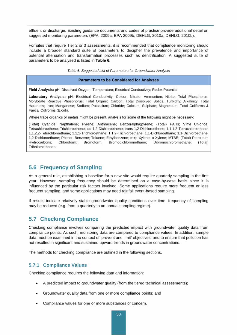
50
effluent or discharge. Existing guidance documents and codes of practice provide additional detail on
suggested monitoring parameters (EPA, 2009a; EPA 2009b; DEHLG, 2010a; DEHLG, 2010b).
For sites that require Tier 2 or 3 assessments, it is recommended that compliance monitoring should
include a broader standard suite of parameters to decipher the prevalence and importance of
potential attenuation and transformation processes such as denitrification. A suggested suite of
parameters to be analysed is listed in Table 6.
Table 6: Suggested List of Parameters for Groundwater Analysis
Parameters to be Considered for Analyses
Field Analysis: pH; Dissolved Oxygen; Temperature; Electrical Conductivity; Redox Potential
Laboratory Analysis: pH; Electrical Conductivity; Colour; Nitrate; Ammonium; Nitrite; Total Phosphorus;
Molybdate Reactive Phosphorus; Total Organic Carbon; Total Dissolved Solids, Turbidity; Alkalinity; Total
Hardness; Iron; Manganese; Sodium; Potassium; Chloride; Calcium; Sulphate; Magnesium; Total Coliforms &
Faecal Coliforms (E.coli).
Where trace organics or metals might be present, analysis for some of the following might be necessary:
(Total) Cyanide; Napthalene; Pyrene; Anthracene; Benzo(alpha)pyrene; (Total) PAHs; Vinyl Chloride;
Tetrachloroethene; Trichloroethene; cis-1,2-Dichloroethene; trans-1,2-Dichloroethene; 1,1,1,2-Tetrachloroethane;
1,1,2,2-Tetrachloroethane; 1,1,1-Trichloroethane; 1,1,2-Trichloroethane; 1,1-Dichloroethane; 1,1-Dichloroethene;
1,2-Dichloroethane; Phenol; Benzene; Toluene; Ethylbenzene; m+p Xylene; o Xylene; MTBE; (Total) Petroleum
Hydrocarbons; Chloroform; Bromoform; Bromodichloromethane; Dibromochloromethane; (Total)
Trihalomethanes.
5.6 Frequency of Sampling
As a general rule, establishing a baseline for a new site would require quarterly sampling in the first
year. However, sampling frequency should be determined on a case-by-case basis since it is
influenced by the particular risk factors involved. Some applications require more frequent or less
frequent sampling, and some applications may need rainfall event-based sampling.
If results indicate relatively stable groundwater quality conditions over time, frequency of sampling
may be reduced (e.g. from a quarterly to an annual sampling regime).
5.7 Checking Compliance
Checking compliance involves comparing the predicted impact with groundwater quality data from
compliance points. As such, monitoring data are compared to compliance values. In addition, sample
data must be examined in the context of ‘prevent and limit’ objectives, and to ensure that pollution has
not resulted in significant and sustained upward trends in groundwater concentrations.
The methods for checking compliance are outlined in the following sections.
5.7.1 Compliance Values
Checking compliance requires the following data and information:
A predicted impact to groundwater quality (from the tiered technical assessments);
Groundwater quality data from one or more compliance points; and
Compliance values for one or more substances of concern.

51
Checking compliance follows the steps outlined in Figure 15. The predicted impact is represented by
a calculation of the concentration of a substance in groundwater after mixing and dilution in
groundwater.
Figure 15: Checking Compliance
For non-hazardous substances, the annual or seasonal (arithmetic) mean concentrations (depending
on authorisation conditions) from sampling are compared against the predicted impact and the
compliance value that has been set for the relevant receptors in questions. The compliance value
should not be exceeded.
For hazardous substances, relevant MRVs must never be exceeded, and seasonal or annual
averages do not apply.
If a compliance value is exceeded, compliance has not been achieved, and the causes for the non-
compliance should be investigated.
If the actual sample results are very different from the predicted impact, the causes for this
discrepancy should be investigated so that actual impact can be ascertained with greater confidence.
Steps that might be taken are:

52
Checking that the values used and calculations of expected groundwater concentrations are
correct; and
Reviewing the conceptual model and possibly conducting additional site investigation to
address areas of uncertainty.
If compliance has not been achieved, further control measures at the source may be required (e.g.
improved pre-treatment of the effluent), or in a worst case even cessation of the discharge activity.
Where the effluent treatment has to be improved, the expected effluent concentrations should be
ascertained (e.g. from manufacturers of package plants) and new mixing calculations carried out until
the regulator is satisfied that the new effluent quality will achieve compliance, with subsequent
continued compliance monitoring.
5.7.2 Sustained Upward Concentration Trends
Long-term compliance monitoring data should be used to ascertain whether or not the authorised
discharge activity is resulting in a sustained upward concentration trend of any substances of
concern. An example of a sustained upward concentration trend is shown in Figure 16.
A statistically significant trend is one that is identified using a recognised statistical trend assessment
technique. An environmentally significant trend is one that is statistically significant, which if not
reversed would lead to the failure of one or more of the WFD’s environmental objectives. As
groundwater data have asymmetric or non-normal distributions, non-parametric statistical methods
are required for trend assessment. Many groundwater systems have considerable seasonal variability
in parameter concentrations, which can impact on trend assessments. The non-parametric Seasonal
Kendall test is a statistical method that reduces the impact of seasonality on trend assessments.
Where significant and sustained upward trends are identified, e.g. from a contaminant plume, the
upward trends need to be reversed to prevent failure of the relevant WFD objectives. The start date
for trend reversal is based on the significance of the trend and the risk associated with failing an
objective of the WFD. By default, Schedule 8 (Part B) of the Regulations indicates that the starting
point for trend reversal is the date when 75% of the Threshold value is likely to be exceeded. Further
details are given in Craig and Daly (2010).
Figure 16: Example of Sustained Upward Concentration Trend

53
6 References
Baker, G., Crean, D., and Moran, S. (2007). Establishing Natural Background Levels for Groundwater
in Ireland. The GSI Groundwater Newsletter No. 46. April 2007.
BGS (2007). Assessing the Impact of Sewage Effluent Disposal on Groundwater. Science Report
SC010070/SR. Prepared by BGS for Environment Agency.
British Standards (1999). Code of Practice for Site Investigations BS5930. As amended.
British Standards (2009). Water quality. Sampling. Guidance on sampling of groundwaters. BS ISO
5667-11:2009, BS 6068-6.11:2009. As amended.
Bruen, M., Johnston, P., Quinn, MK., Desta, M., Higgins, N., Bradley, C. and Burns, S. (2006). Impact
Assessment of Highway Drainage on Surface Water Quality (2000-MS-13-M2) Synthesis Report.
Prepared for the EPA by Centre for Water Resources Research, UCD.
CDM (2008). Risk to Groundwater from Diffuse Mobile Organics. Further Characterisation/
Programmes of Measures. Eastern River Basin District. April 2008.
CDM (2009). Urban Groundwater Pressures Assessment. Further Characterisation/ Programmes of
Measures. Eastern River Basin District. March 2009.
CDM (2010). Well Completion Report, Glencastle Catchment, County Mayo. Prepared for Carlow
County Council and the Environmental Protection Agency. July 2010.
CIRIA (2007). The SuDS Manual. (C697). CIRIA publication, February 2007.
CIS (2007). Common Implementation Strategy (CIS) for the Water Framework Directive (2000/60/EC)
Guidance on preventing or limiting direct and indirect inputs in the context of the Groundwater
Directive 2006/118/EC. Guidance Document No. 17.
CIS (2010). Common Implementation Strategy (CIS) for the Water Framework Directive
(2000/60/EC). Guidance on risk assessment and the use of conceptual models for groundwater.
Guidance document No. 26.
Conroy, P. (2010). Establishment of Groundwater Source Protection Zones: Drybridge Water Supply
Scheme: Drybridge Borehole. Prepared by Peter Conroy for GSI. Revision A, May 2010.
Craig, M. and Daly, D. (2010) Methodology for establishing groundwater threshold values and the
assessment of chemical and qualitative status of groundwater, including an assessment of pollution
trends and trend reversal. Environmental Protection Agency. Available on the www.epa.ie website.
Daly, D. and Craig, M. (2009). Chemical and Quantitative Status of Groundwater Bodies. A Measure
of the Present, A Signpost to the Future. IAH Irish Group. Proceedings 29th Annual Groundwater
Conference, International Association of Hydrogeologists, Irish Group, Tullamore, April 21-22, 2009.
Daly, D. (2006). Site suitability for on-site wastewater treatment systems – the role of the water table.
Groundwater Newsletter No. 45. Geological Survey of Ireland.
DEHLG (2004). National Urban Waste Water Study. National Report.
DEHLG (2009). Appropriate Assessment of Plans and Projects in Ireland. Guidance for Planning
Authorities.
54
DEHLG (2010). Integrated Constructed Wetlands — Guidance Document for Farmyard Soiled Water
and Domestic Waste water Applications. July 2010.
DELG/EPA/GSI (1999). Groundwater Protection Schemes. Document prepared jointly by the
Geological Survey of Ireland (GSI), the Environmental Protection Agency, and the Department of
Environment, Heritage and Local Government.
Environment Agency (2009). Hydrogeological Risk Assessment for Landfills and Derivation of
Groundwater Control and Trigger Levels.
Environment Agency (2010a). Groundwater risk assessment of treated effluent discharges to
infiltration systems.
Environment Agency (2010b). Assessing discharges of sewage and trade effluent to ground.
Operational Instruction 55 03. Draft.
EPA (1995). Landfill Manual – Guidance Note on Investigations for Landfills.
EPA (1997) Landfill Manual – Landfill Operational Practices.
EPA (1999). Waste water Treatment Manual - Treatment for Small Communities, Business, Leisure
Centres and Hotels.
EPA (2000). Landfill Manual – Landfill Site Design.
EPA (2003). Landfill Manual – Guidance Note of Landfill Monitoring.
EPA (2003). Towards Setting Guideline Values for the Protection of groundwater in Ireland. Interim
Report.
EPA (2006). Ireland Water Framework Directive Monitoring Programme.
EPA (2009a). Code of Practice: Waste Water Treatment and Disposal Systems serving Single
Houses (p.e. <10).
EPA (2009b). Waste Water Discharge Certificate of Authorisation: Application Guidance Notes.
EPA (2009c). Waste Water Discharge Licensing – Appropriate Assessment.
EPA (2010a). The Classification of Hazardous and Non-Hazardous Substances in Groundwater.
EPA (2010b). Methodology for Establishing Groundwater Threshold Values and the Assessment of
Chemical and Quantitative Status of Groundwater, Including and Assessment of Pollution Trends and
Trend Reversal.
Fitzsimons, V., Daly, D. and Deakin, J. (2003). Draft GSI guidelines for assessment and mapping of
groundwater vulnerability to contamination. Groundwater Section, Geological Survey of Ireland.
Galway County Council (2009). Guidelines for the Discharge of Effluent to Waters from Industrial,
Commercial Developments, and Communal Housing (> 2 House) Developments. Advice Note 2.
Gill, L.W., O’Luanaigh, N., Johnston, P.M., Misstear, B.D.R, O`Suilleabhain, C. (2009). Nutrient
loading on subsoils from on-site wastewater effluent, comparing septic tank and secondary treatment
systems. Water Research 43, 2739-2749.
55
Gill, L., Johnston, P., Misstear, B., O'Luanaigh, N. and Patel, T. (2008). On-site waste water
treatment: investigation of rapid percolating subsoils, reed beds and effluent distribution. Final Report
for project 2005-MS-15 ERTDI. Prepared for the Environment Protection Agency by The
Environmental Engineering Group, TCD.
Gill, L. (2006). Expert assistance for assessment of percolation test methods and wastewater
treatment effluent characteristics: Final Report. Prepared for the Environmental Protection Agency.
2006.
Gill, L., Ó Súilleabháin,, C., Johnston, P. and Misstear, B. (2005). An investigation into the
performance of subsoils and stratified sand filters for the treatment of waste water from on-site
systems. (2001-MS-15-M1) Synthesis Report. Prepared for EPA by The Environmental Engineering
Group, TCD.
GSI (2006). Criteria used in aquifer classification. Available from
http://www.gsi.ie/Programmes/Groundwater/Aquifer+Classification.htm.
IGI (2007). Guidelines on Water Well Construction. Available from
http://www.igi.ie/assets/files/Water%20Well%20Guidelines/Guidelines.pdf
Kilroy, G., Dunne, F., Ryan, J., O’Connor, A., Daly, D., Craig, M., Coxon, C., Johnston, P. and Moe,
H. (2008). A Framework for the Assessment of Groundwater – Dependent Terrestrial Ecosystems
under the Water Framework Directive.Environmental Research Centre Report Series No. 12.
Metcalf and Eddy Inc. (2004). Waste Water Engineering: Treatment and Reuse. 4th ed. revised by
George Tchobanoglous. McGraw-Hill, New York: 2003.
Moe, H., Craig M., and Daly, D. (2010). Poorly Productive Aquifers – Monitoring Installations and
Conceptual Understanding. Published by the Environmental Protection Agency.
Ó Súilleabhaín, C., 2004. The Attenuation Capacity of Subsoils Receiving Domestic Wastewater
Effluent. PhD Dissertation, Dept. Civil, Structural and Environmental Engineering, Trinity College
Dublin.
SEPA (2008). The Water Environment (Controlled Activities) (Scotland) Regulations 2005. A Practical
Guide.
SEPA (2009a). Regulatory Method (WAT-RM-04). Indirect Sewage Discharges to Groundwater.
SEPA (2009b). Regulatory Method (WAT-RM-06). Trade Effluent Discharges to Groundwater.
SEPA (2010). Assigning Groundwater Assessment Criteria for Pollutant Inputs. WAT-PS-10-01.
March 2010.
Smith, J.W.N. and Lerner, D.N. (2007). A framework for rapidly assessing the pollutant retardation
capacity of aquifers and sediments. Quarterly Journal of Engineering Geology and Hydrogeology, 40.
137-146.
SNIFFER (2007). WFD Visualisation Package. Published by the Scotland & Northern Ireland Forum
for Environmental Research. Available on the www.wfdvisual.com website.
Spain R., Glasgow, G., and Fay, K. (2009). Practical implementation of the Water Framework
Directive with respect to groundwater by Local Authorities. Proceedings 29th Annual Groundwater
Conference, International Association of Hydrogeologists, Irish Group. Tullamore, April 21-22, 2009.
Swartz M., Misstear B., Daly D., Farrell E. (2003). Assessing subsoil permeability for groundwater

56
vulnerability. Q J Eng Geol Hydrogeol 36:173–184
UK TAG (2007). Proposals for a groundwater classification system and its application in regulation.
UK Technical Advisory Group. Available on the www.wfduk.org website.
UK TAG (2008). Application of Groundwater Standards to Regulation. UK Technical Advisory Group
Paper 11b(iii). Available on the www.wfduk.org website.
UK TAG (2011). Defining & Reporting on Groundwater Bodies. UK Technical Advisory Group.
Working Draft Paper.
Water Services National Training Group (2010). Guidance Manual: Guidance, Procedures and
Training on the Licensing of Discharges to Surface Waters and to Sewer for Local Authorities.
DEHLG.
Wexford County Council (2008). Guidelines for Water Pollution Licensing & Discharge of Effluent to
Water. Advice Note 3, Version 2.
WGGW (2005a). Guidance on the Assessment of the Impact of Groundwater Abstractions. Guidance
Document No. GW5. Paper by the Working Group on Groundwater. March 2005.
WGGW (2005b). Methodology for Risk Characterisation of Ireland’s Groundwater. Guidance
Document No. GW8. Paper by the Working Group on Groundwater. March 2005.

57
References on Legislation
European Directives:
Water Framework Directive (2000/60/EC);
Groundwater Directive (2006/118/EC).
Irish Government Acts and Regulations:
Local Government (Water Pollution) Acts 1977 to 1990;
European Communities (Quality of Salmonid Waters) Regulations, 1988 (S.I. No. 293 of 1988);
European Communities (Natural Habitats) Regulations, 1997 (S.I. No. 94 of 1997 as amended by S.I.
No. 233 of 1998 and S.I. 378 of 2005);
Environmental Protection Agency Acts, 1992 to 2011;
Waste Management Acts, 1996 to 2011;
European Communities (Water Policy) Regulations, 2003 (S.I. No. 722 of 2003);
European Communities (Quality of Shellfish Waters) Regulations, 2006 (S.I. No. 268 of 2006);
Water Services Act, 2007;
European Communities (Drinking Water) (No. 2) Regulations, 2007 (S.I. No. 278 of 2007);
Waste Water Discharge (Authorisation) Regulations 2007 and 2010 (S.I. No 684 of 2007 as amended
by S.I. No. 231 of 2010);
Bathing Water Quality Regulations, 2008 (S.I. No. 79 of 2008);
European Communities Environmental Objectives (Surface Water) Regulations, 2009 (S.I. No. 272 of
2009);
European Communities Environmental Objectives (Groundwater) Regulations, 2010 (S.I. No. 9 of
2010);
European Communities (Good Agricultural Practice for Protection of Waters) Regulations, 2010 (S.I.
No. 610 of 2010).
The following is a list of useful websites from which to source environmental legislation.
www.irishstatutebook.ie The Irish Statute Book database comprises the legislation directories
for National Acts of the Oireachtas, and Statutory Instruments; and
http://eur-lex.europa.eu/ provides access to European Union Law.

58