Embed Size (px)
Citation preview
1 _______________________________________________________________________________________ OSPAR Commission OSPAR Agreement 2019-05
Guidance on the Development of Status Assessments for the OSPAR List of Threatened and/or Declining Species and Habitats
(OSPAR Agreement 2019-05)1
Contents 1. Purpose and scope of the Guidance .......................................................................................................... 3
2. Purpose of the status assessments ........................................................................................................... 3
3. Time period to be assessed and previous status assessments of OSPAR-listed species and habitats ...... 4
4. Frequency and timing of the status assessments ..................................................................................... 5
5. Preparing an assessment ........................................................................................................................... 9
5.1 Anticipated resource requirement .......................................................................................................... 9
5.2 Starting points ......................................................................................................................................... 9
5.3 Information sources .............................................................................................................................. 10
5.3.1 OSPAR common indicators ............................................................................................................. 10
5.3.2 Human activity trend and intensity information for the OSPAR maritime area ............................ 10
5.3.3 Third party information .................................................................................................................. 11
5.3.4 Proxy information ........................................................................................................................... 12
5.3.5 Expert judgement ........................................................................................................................... 12
5.4 Audit trail ............................................................................................................................................... 19
5.5 Status assessment criteria ..................................................................................................................... 19
5.5.1 Aggregation of information ............................................................................................................ 20
5.5.2 Integration of assessments ............................................................................................................. 20
5.5.3 Confidence ...................................................................................................................................... 21
5.6 Approach to be used to assess human activities and threats ............................................................... 21
5.7 Assessment of implementation of measures and their effectiveness .................................................. 22
6. Assessment contents and sign-off ........................................................................................................... 23
6.1 Contents ................................................................................................................................................ 23
1 English only. Update 2021

2 of 40
OSPAR Commission OSPAR Agreement 2019-05
6.2 Sign-off process ..................................................................................................................................... 23
7. Use and dissemination of outputs ........................................................................................................... 24
8. References ............................................................................................................................................... 25
ANNEX A: Detailed guidance on the contents of a species or habitat assessment sheet ............................ 26
Assessment sheet template ....................................................................................................................... 26

3 of 40
OSPAR Commission OSPAR Agreement 2019-05
1. Purpose and scope of the Guidance
The purpose of this technical Guidance is to provide OSPAR Contracting Party experts with practical advice on how to prepare status assessments of the threatened and/or declining species and habitats on the OSPAR list (Agreement 2014-02; https://www.ospar.org/work-areas/bdc/species-habitats/list-of-threatened-declining-species-habitats). Section 2 below describes the purpose of the status assessments and the relationship between a status assessment and an assessment against Texel-Faial criteria for listing/delisting.
This Guidance document is intended to be used by OSPAR expert groups, national experts and policy-makers who will be directly involved in OSPAR assessment work.
The Guidance describes the rationale for undertaking the assessments, the frequency and timing in the short term to deliver a number of assessments for the OSPAR Quality Status Report 2023 (QSR 2023), the assessment criteria, sources of information, optional data sources, the reporting format required by OSPAR, and describes the intended uses and dissemination of the assessment outputs.
The guidance provides a framework that describes the relationship of status assessments to OSPAR Recommendations, Agreements and other documents of relevance to work on the OSPAR list of Threatened and/or Declining Species and Habitats.
The results of each assessment will be recorded and presented as a 2-page assessment sheet. A template for the assessment sheet is provided in Annex B of this Guidance. Additional information can also be captured in the template and this will be used to provide an audit trail of the process undertaken to conduct the assessment.
BDC will regularly review this guidance document to ensure it remains appropriate to support the delivery of OSPAR’s regular assessment requirements.
2. Purpose of the status assessments
The assessment of the status of species or habitats is intended to inform OSPAR’s consideration of the effectiveness of the measures and actions that have been adopted and implemented by Contracting Parties. Thus, the focus of the assessment should be to explore if existing measures are effective and sufficient. This can be done by assessing the status of a feature, or through a proxy approach, by assessing changes in human activities and pressures that are threats to the feature.
The assessment process to be followed for the listing or delisting of any species and habitats from the OSPAR List has been set out in Agreement 2019-04 on Guidelines on the review of the OSPAR list of Threatened and/or Declining Species and Habitats. An assessment for listing or delisting is based on the Texel-Faial criteria.
The status assessments, on which this document provides guidance, of an OSPAR Threatened and/or Declining Species and Habitat can inform the case developed by a Contracting Party or observer organisation for delisting.
An example of the type of conclusion aspired to at the end of an assessment is:

4 of 40
OSPAR Commission OSPAR Agreement 2019-05
The status of Black-legged Kittiwake breeding populations is still declining in Arctic Waters and the Greater North Sea and is now also declining in the Celtic seas and the Bay of Biscay. Threats from climate change appear to be continuing in all regions, although causes of change in Bay of Biscay are unknown. Threats from sandeel fishing in the North Sea still exists in some areas.
The starting point for any status assessment is to consider information used to support the listing of a feature, i.e. the Case Report and the Background Document. The information generated through the status assessment process will inform OSPAR’s future decision-making on (among other things):
a. developing additional guidance to Contracting Parties on the implementation of OSPAR Recommendations for OSPAR listed Species and Habitats;
b. revising existing OSPAR Recommendations or developing additional Recommendations; c. communicating with other competent authorities on the need for action, for example, with
respect to questions relating to management of fisheries or maritime transportation; d. reviewing the continued inclusion of a species or habitat on the OSPAR List (a status assessment
could trigger a proposal for delisting following the process in Agreement 2016-02, see below); e. communication actions related to the OSPAR List of Threatened and/or Declining Species and
Habitats. An assessment(s) concluding that a species or habitat continues to be in poor status (in the sense of the Texel-Faial criteria) should initiate a review of whether there is a need for additional guidance to Contracting Parties on the implementation of OSPAR Recommendations for the OSPAR List of Threatened and/or Declining Species and Habitats. Where measures lie outside of OSPAR’s competence (for example, with respect to questions relating to management of fisheries or maritime transportation), communication may be needed with other competent authorities on the need for action. Where measures have been effectively implemented and have had sufficient time to come into effect, a poor status assessment may be used to trigger an update of the Background Document and the revision of the existing OSPAR Recommendations or the development of additional Recommendations.
An assessment(s) concluding that a species or habitat is in good status (if sustained over a sufficient period, which may need to be further specified) should raise questions on the continued inclusion of a species and habitat on the OSPAR List.
3. Time period to be assessed and previous status assessments of OSPAR-listed species and habitats
Each status assessment must clearly state the time period that has been assessed. There is no prescribed assessment period which needs to be considered in the status assessments. As the aim of the assessment is to conclude on whether the feature still warrants priority action by OSPAR, the relevant period to be assessed would be from when the latest status assessment was completed, and/or, the time when the feature was included on the OSPAR List.
In order to understand any changes observed, it may be relevant to consider trend information for as long a period as possible, up until the date of the assessment. If possible, the status of the population, the human activities and threats and implemented measures would be assessed over the same time period, however it must be recognised that data availability may limit the possibility for such an assessment.
OSPAR’s last assessments of the listed species and habitats (the so called JAMP BA-4 assessments) were prepared for the QSR2010 and are included in section 3 of the Background Documents, which describes the
5 of 40
OSPAR Commission OSPAR Agreement 2019-05
current status of each species and habitat. These assessments compiled updated information on distribution, population/abundance and condition of species; and on distribution, extent and condition of habitats. Information was drawn from a wide variety of available sources, including assessments and evaluations prepared by other organisations and through other processes. This information was selected and compiled by national lead authors with the content being subsequently approved for publication by BDC. National assessment data and information provided by Contracting Parties was summarised in an annex to the Background Document with a view to use for other reporting purposes, such as the 2012 MSFD Initial Assessment. The purpose of an OSPAR Background Document, in general, is to provide information to inform the drafting of OSPAR Recommendations on measures.
All Background Documents can be accessed in chapter 10 of the electronic-QSR2010. To access the Background Documents under the section “What has been done” open Table 10.2 for species or Table 10.3 for habitats and click on the species or habitat name.
4. Frequency and timing of the status assessments2
This guidance document instructs the second round of status assessments of the OSPAR Listed Threatened and/or declining species and habitats. The status assessments are to be conducted within a 6-year period, meaning the meeting cycles 2019/2020 – 2024/2025.
The publication of the QSR 2023 occurs in the middle of this period. Status assessments to be included in the QSR 2023 need to be completed and agreed by BDC 2022.
A lead country approach will be taken such that one Contracting Party will take responsibility for the status assessment of each feature (or group of features). The lead country needs to develop and finalise the assessments in cooperation with experts from all relevant OSPAR Contracting Parties. To be efficient with resources, assessments will be grouped thematically.
The tentative proposed timing for status assessments is included in Table 1. This timetable takes a pragmatic approach and aims to make best use of existing OSPAR subsidiary groups and of assessment work being undertaken by third party organisations.
For clarity, if an assessment is undertaken during the meeting cycle 2019/2020, the draft assessment would be presented to ICG-POSH 2019, and the final assessment would be agreed by BDC 2020.
The frequency and timing of future status assessment rounds will be finalised by the end of 2024 and will be based on experiences from this second round of assessments.
Table 1 (below).Timing of status assessments in the upcoming 6-year period. The table indicates suggested arrangements for completing the assessments, (Table updated in 2021. Please refer to JAMP product B3 for more recent updates)
2 The criteria guiding the choice of frequency and timing for the status assessments stem from discussions held at ICG-POSH (2) 2016, which were captured in the draft guidance outline presented to BDC 2017 (BDC 17/4/2-E).

6 of 40
OSPAR Commission OSPAR Agreement 2019-05
2018/2019 Test year
2019/2020
6 assessments
2020/2021
17assessments
2021/2022 Overflow year
18 assessments
2022/2023 Lessons learned year
2023/2024
19 assessments
Habi
tats
OBHEG
- Maerl beds (UK)
- Flat oyster (NL, DE)
- Ostrea edulis beds (NL, DE)
Intertidal WS (NL hosting WS)
- Intertidal Mytilus edulis beds on mixed and sandy sediments
- Intertidal mudflats
- zostera beds (SE tbc)
- Sea-pen and burrowing megafauna (UK)
Deep sea WS (IE hosting WS)
- Deep-sea sponge aggregation (SE+SponGES)
- Coral gardens
- Lophelia pertusa
- Oceanic ridges with hydrothermal vents/fields
- Seamounts
- Carbonate mounds
- modiolus modiolus beds
- Cymodocea meadows
- Littoral chalk communities
- Sabellaria spinulosa

7 of 40
OSPAR Commission OSPAR Agreement 2019-05
2018/2019 Test year
2019/2020
6 assessments
2020/2021
17assessments
2021/2022 Overflow year
18 assessments
2022/2023 Lessons learned year
2023/2024
19 assessments Fi
sh - Houting (DK)
- Sturgeon (DE)
ICES advice
- Gulper shark (IE)
- Leafscale gulper shark (IE)
- Portuguese dogfish (IE)
ICES advice part I
- Angel shark (IE)
- Common skate(IE)
- Spotted ray (IE)
- Thornback ray/skate (IE)
- White skate (IE)
ICES advice part II
- Basking shark (IE)
- Porbeagle shark (IE)
- spurdog (IE)
- Allis shad (FR)
- Sea lamprey (NO)
- eel (FR)
- salmon (FR)
- bluefin tuna
- cod
- orange roughy
- long-nosed seahorse
- short-snouted seahorse
Mam
mal
s - trial assessment of Harbour porpoise (NL)
- Blue whale (NL)
- Bowhead whale (BE, NL)
- Northern right whale (BE, NL)
- Harbour porpoise

8 of 40
OSPAR Commission OSPAR Agreement 2019-05
2018/2019 Test year
2019/2020
6 assessments
2020/2021
17assessments
2021/2022 Overflow year
18 assessments
2022/2023 Lessons learned year
2023/2024
19 assessments Bi
rds Trial assessment of
Black-legged kittiwake (UK, JWGBIRD)
- Thick-billed murre (NO)
- Lesser black-backed gull (NO)
- Roseate tern (PT)
- Balearic shearwater (ES)
- Black-legged kittiwake (UK)
- Iberian guillemot (ES/PT)
JWG BIRD
-Ivory gull
-Little shearwater
-Stellers eider
Rept
iles - Leatherback turtle (FR,
Turtle EG)
- Loggerhead turtle (FR, Turtle EG)
Inve
rteb
rate
s - Dog whelk - Azorean Barnacle
- Azorean limpet
- Ocean quahog
_______________________________________________________________________________ OSPAR Commission OSPAR Agreement 2019-05
9
5. Preparing an assessment
5.1 Anticipated resource requirement
Completing a status assessment for a feature can be anticipated to require approximately 2-3 working weeks. However, the resource requirement could differ substantially between assessments, depending on data availability/quality, data richness of the feature and the distribution of the feature across regions. Thus, some status assessments will be more time-consuming than indicated below.
Assessments for data-rich features included in OSPAR indicators should be derived from existing OSPAR indicator data sets and assessment results. Features that are not included in existing OSPAR indicators or datasets, are likely to be data-poor. Assessments of these features may require a call to Contracting Parties to provide any data or information. If data are forthcoming, a status assessment should typically not require compilation of new regional datasets. However if resource is available, then compiling regional datasets is welcomed.
Where data are lacking, the assessment may take the form of a literature-review and may require an expert judgement approach. Completing the audit trail (see section 5.3) in detail for data poor features is particularly important. Furthermore, some features may be data rich in some regions but data-poor in others. In such cases, a combination of the approaches described above will be required.
Once all the information has been collated, a first draft of the two-page assessment sheet can typically be developed within one week by the lead party. A review of the draft text by a co-lead party can typically be done within 0.5 to 1 day.
Substantiating the information, by ensuring all OSPAR Contracting Parties have considered and reviewed it, can be done through the relevant OSPAR Expert Group (EG), or through a dedicated workshop and then presented to appropriate OSPAR Intersessional Correspondence Group (ICG). This process could be achieved via scheduled meetings or intersessionally, with the agreement of relevant conveners.
5.2 Starting points
Before preparing an assessment, task leads should familiarise themselves with existing OSPAR sources of information about the listed habitat or species.
Key resources
• OSPAR List of Threatened and/or Declining species and Habitats (Agreement 2008-6) (presented on webpage https://www.ospar.org/work-areas/bdc/species-habitats/list-of-threatened-declining-species-habitats)
• Case Report for each listed feature (compiled in publication at: https://www.ospar.org/documents?v=7099)
• Background Document on species or habitat • OSPAR Recommendation on species or habitat and national implementation reports from
2013, 2016, 2019 (available through a bespoke database (currently under development), overviews of 2016 reporting available online in the webpage under first bullet point)
• Check which regions the species or habitat has been listed for. Check OSPAR List of Threatened and/or Declining Species and Habitats Agreement 2008-6 which sets out which regions the species or habitat has been listed for. Note that assessments should also be

_______________________________________________________________________________ OSPAR Commission OSPAR Agreement 2019-05
10
carried in regions where the habitat or species were not considered to be threatened or declining when the Background Documents were published; the status in these regions may have changed subsequently.
• Check the justification for including the species or habitat on the list. This is provided in the Case Report, available in the section of the Background Document titled “Original Evaluation against the Texel-Faial selection criteria” or in the compilation document (see above box). The assessment should refer back to this original assessment and be focused on the key criteria that were used to justify inclusion in the list.
• Check the date of inclusion in the list and the date of the last assessment. The date of inclusion in the OSPAR List represents a baseline for the consideration of the effect of OSPAR actions or measures. The date of the last assessment, which in most cases is 2009, helps to define the assessment period of most interest (i.e. from last assessment to current assessment). In most cases the Background Document provides the latest available compiled information on the status of the features and the human activities threatening the feature.
• Check the Recommendation for the measures and actions to be implemented for each feature and the latest implementation reports
• Check EIHA DOCUMENTS for recent assessments of the relevant human activities • Check if the feature has recently been assessed as part of an OSPAR common indicator • Check if the feature has recently been assessed by a third party (see guidance in separate
section). The use of 3rd party assessments is encouraged as a means of achieving a pragmatic approach which does not require a big resource investment.
5.3 Information sources
The anticipated resource requirement should be recalled when considering the relevant information source. When possible, the assessment of status should be based on quantitative analysis of regional scale monitoring data (Figure 1) and use Common Indicator assessments where relevant. In the absence of quantitative OSPAR assessment, –assessors are encouraged to make as much use as possible of assessments and evaluations from other international organisations working on the OSPAR species and habitats, referred to here as 3rd party assessments.
5.3.1 OSPAR common indicators The primary source of information should be from OSPAR common indicator assessments being developed for the QSR 2023. If one or more indicator assessments are integrated to assess species or habitat status, then the approach should follow methods for integration that have been agreed or are being developed within OSPAR3. If the species or habitat was not included in these assessments, attempts should be made to make best use of available monitoring data; existing catalogues can be consulted. If applicable, OSPAR indicator methods should be applied to interpret the monitoring data.
5.3.2 Human activity trend and intensity information for the OSPAR maritime area Feeder reports on selected human activities describing extent, distribution and intensity of the activity, socio-economic data, trend information and assessments of measures were produced for the purposes of the QSR 2023 by EIHA.
3 As part of the implementation of the 2017 EU Commission Decision on MSFD, OSPAR has been requested by the Commission to help to develop integration methods for all biodiversity elements.
_______________________________________________________________________________ OSPAR Commission OSPAR Agreement 2019-05
11
These reports are a valuable source of information on the selected human activities that has been compiled to be relevant for the regional perspective of OSPAR. The information has also been considered and agreed by EIHA. The feeder reports should be the first point of call for an assessment lead when completing the status assessment template.
Feeder reports are published https://oap.ospar.org/en/ospar-assessments/quality-status-reports/qsr2023/other-assessments/.
5.3.3 Third party information Making greatest possible use of assessments prepared by other organisations who consider the status of the species and habitats in their work (3rd party assessments) is an encouraged, pragmatic approach to JAMP B3 status assessments. These 3rd party assessments include work done by other international conventions, regional and international frameworks and EU legal assessment and reporting obligations, etc. A detailed decision tree that examines the questions that should be asked when determining if a 3rd party assessment can be used (Figure 2).
The international organisations and processes listed in Table 2 have been identified as addressing the conservation status of one or more species and/or habitats on the OSPAR List in all or part of the OSPAR maritime area. It should cover most of the relevant organisations, but may not be a totally exhaustive list.
Table 2. List of 3rd party status assessments to be considered likely to cover OSPAR T&D species or habitats in all or parts of the OSPAR maritime area.
Assessment name
EU Habitats Directive EU Birds Directive EU Water Framework Directive (WFD) International Union for Conservation of Nature (IUCN) Red List International Council for the Exploration of the Sea (ICES) fish stock assessment Agreement on the Conservation of African-Eurasian Migratory Waterbirds (AEWA) Convention on Migratory Species (CMS) North Atlantic Marine Mammal Commission (NAMMCO) Bern Convention International Whaling Commission (IWC) International Commission for the Conservation of Atlantic Tunas (ICCAT) The North Atlantic Salmon Conservation Organization (NASCO) HELCOM Conservation of Arctic Flora and Fauna (CAFF)
An excel spreadsheet has been compiled to identify which 3rd party organisations work on which specific species and habitats. Note that there are separate spreadsheets for species and habitats.
Many of the habitats assessed under the Habitats Directive are much broader than the definition under the OSPAR List. This makes it difficult to use the Habitats Directive assessments of these habitats, as the OSPAR habitat might account for a just a small part of the assessment, but it is not possible to separate this out. In these cases, the Habitat Directive assessment could still be used for context.
High-level (i.e. general) information on the assessment work carried out by each organisation (including OSPAR) has been compiled in two excel spreadsheets in the excel workbook at Addendum
_______________________________________________________________________________ OSPAR Commission OSPAR Agreement 2019-05
12
24. In this workbook, the first excel spreadsheet - Summary table tab - compiles general information on the assessment work carried out by each organisation or process across the following fields: Summary table tab:
• High level aspirations • Assessment requirement • Geographic scope • Reporting scale • Biological scope (species and habitats) • Reporting cycle frequency • Baselines used • Approach for preparing assessment • Relevant assessment output • Where published
The second excel spreadsheet tab – assessment considerations tab – compiles more detailed information on the issues addressed in each assessment, classification systems and where possible the detailed criteria used for status classification. The latter criteria are organised with respect to the (proposed) JAMP B3 assessment issues for species and habitats, suggested in Table 1. Assessment considerations tab
• High-level assessment criteria • Assessment status classes • Detailed assessment criteria (where available) organised according to OSPAR assessment
criteria. While the assessment work of some processes, such as IUCN or the OSPAR List, is focused on a risk of extinction, others, such as Habitats Directive or CMS, address conservation status. However, it is possible to see commonalities between the aspects assessed through different processes, with most assessment processes addressing in some way the same assessment criteria suggested for the OSPAR JAMP assessment. Table 3A and 3B compile the assessment criteria covered by the 3rd party assessment processes considered and compare these with the suggested JAMP B3 assessment criteria.
The excel spreadsheet at Addendum 3 – correlation table – applied the proposed decision process to considering the use of 3rd party assessments for the Roseate Tern, Intertidal mudflats and Leatherback turtle.
5.3.4 Proxy information If monitoring data and/or indicators are unavailable, a proxy assessment using information on human activities or pressures to which the species or habitat is sensitive can be conducted. For example, using spatial information on the distribution of the feature and the human activities or pressures that may affect the feature, along with information on the known sensitivity of the feature to those pressures.
5.3.5 Expert judgement If assessments cannot be made based on the types of evidence described above, it should be considered if information is available to support an expert judgement assessment. If expert judgement
4 This table is based on the High Level Summary Table presented in: Hinchen, H., (2014), Review of marine biodiversity assessment obligations in the UK., JNCC Report 497 Part I, ISSN 0963 8901. Information is as complete as can it be by submission date for ICG-POSH but it has not been possible to complete all fields for all organistions.

_______________________________________________________________________________ OSPAR Commission OSPAR Agreement 2019-05
13
is required, the following key points should be considered to ensure a robust assessment (Barnard and Boyes 2013):
• there should be a transparent and structured process to help plan and guide elicitation work, and to provide an audit trail of decision-making in the light of expert opinion;
• the selection of experts is important and should include an appropriately wide range of views and expertise including not only technical specialists, but also practitioners and stakeholders, that is, those with a broader perspective;
• opinions from different experts can be weighted; and • techniques other than simple requests for quantitative data can be used to help capture
information. The approach that the expert judgement process takes will depend partly upon the body of information that is available (i.e. scientific papers, grey literature, anecdotal evidence).
Where experts from other Contracting Parties are identified to contribute, such as through workshops, it is important that ICG-POSH delegates from the corresponding Contracting Parties are aware and informed for information purposes. It is therefore recommended, that when experts are approached to contribute to an assessment, the respective ICG-POSH delegate is included in that initial correspondence. This will ensure that Contracting Parties are aware of which national experts are contributing to these assessments, and where appropriate have the opportunity to suggest additional expertise.

______________________________________________________________________________________________________________________________ OSPAR Commission OSPAR Agreement 2019-05
14
Table 3A. Species: comparison of assessment criteria between OSPAR and 3rd parties.
JAMP B3 OSPAR List Texel Faial
Habitats Directive
Birds Directive CMS AEWA IUCN Red List ICES fish IWC MSFD
Distribution Decline in extent of
occurrence Range
Breeding distribution &
range size Breeding range
trend
Species range Population distribution
Breeding range
Wintering distribution
Range (Extent of
occupancy, Area of occupancy)
Distribution
Population Decline in numbers
Population Population size
Population trend
Population distribution
and abundance
Population size
Population size Small population
Spawning stock
biomass
Stock size (and
trends) Abundance
Condition Decline in
quality
Population Habitat for
species
Population dynamic and
viability
(Migration routes)
Mature individuals incl. above
Habitat quality included in Range
Carrying capacity
Productivity
Size, age and sex structure
Fecundity, survival and mortality
Behaviour (movement and migration)
Habitat for species

______________________________________________________________________________________________________________________________ OSPAR Commission OSPAR Agreement 2019-05
15
Threats/ pressures5
Links to human
activities
Future prospects Ranking of pressures
and threats
Main pressures and threats
Progress in implementation of
action/ management plans
SPA coverage and measures
Probability of
extinction Fishing
mortality
Table 3B. Habitats: comparison of high-level assessment issues between OSPAR and 3rd parties.
JAMP B3 OSPAR List (Texel Faial)
Habitats Directive IUCN Red List approach6 MSFD (Annex III) MSFD (proposed revised Annex III)
Distribution Decline in extent Range Existing and trends in quantity (extent of occurrence) Restricted distribution
Distribution Distribution
Extent Decline in extent Area covered Existing and trends in quantity (area of occurrence) Restricted distribution
Extent Extent (and volume if appropriate)
5 Threats are defined in different ways by different 3rd party assessments (e.g. a threat may be a event that may have an impact in the future or it may be a probability of extinction). It should be noted that threats and pressures have not been examined in detail for this piece of work. 6 Based on “A feasibility assessment for Red List Assessment for European Habitat types prepared by Rodwell, Janssen, Gubbay and Schaminée under commission from the European Commission (April 2013) including a review of typologies and thresholds for red list assessment”

______________________________________________________________________________________________________________________________ OSPAR Commission OSPAR Agreement 2019-05
16
Condition Decline in quality (typical or natural components)
Structures and functions Quality (abiotic, biotic) Condition Species composition Abundance biomass Size and age structure of species
Threats/ pressures
Links to human activities
Future prospects
Ranking of pressures and threats
Probability of collapse

17 of 40
OSPAR Commission BDC 19/4/13
Figure 1. Data and information source decision tree

18 of 40
OSPAR Commission OSPAR Agreement 2019-05
Figure 2. 3rd party assessment decision tree (extracted from paper ICG-POSH (2) 16/3/3)

19 of 40
OSPAR Commission OSPAR Agreement 2019-05
5.4 Audit trail
Each assessment will be completed using the assessment sheet template in Annex A of this Guidance.
At the end of the assessment sheet template, is a section for capturing additional evidence and information that will provide an audit trail which documents the assessment process, the sources of information and any decisions made to e.g. include or exclude data. This ‘Audit Trail’ section of the template is designed to hold additional supportive information and evidence on assessment methods; assessments of each criterion (see Section 5.5) and of threats and impacts; measures that address key pressures from human activities or conserve the species/habitat and knowledge gaps. Filling in each part of the Audit Trail section is optional and not subject to a word limit. It should also include citations of the sources of evidence and information and provide full references.
Capturing additional information can be useful for well-studies species and habitats where there is a large quantity of evidence that is difficult to compress into the 2-page assessment. It is also useful for assessments of data-poor species and habitats that are based largely on expert judgement. This audit trail section can be used to capture the rationale underlying the judgements made so that they can be reassessed and challenged at a later date.
The audit trail information may not necessarily be published, the resulting document could be archived by OSPAR. Alternatovely, it could either be presented online, alongside the 2-page assessments ( as per the IA2017 indicator assessments) or as a separate downloadable pdf report. Whatever option is used, it should ensure that any consecutive assessments can access more detailed information than simply the concise results and so that any questions on the steps taken in compiling the information can be clarified, or added to, if needed.
5.5 Status assessment criteria
The criteria7 that need to be assessed are summarised in the box below. The decision trees outlined in Figure 1 and Figure 2 should be considered for each criterion separately as there may be multiple sources of information available for each.
Assessment criteria (as used in the Background Documents)
For species:
- Distribution – current trends and future prospects - Population size/abundance – current trends and future prospects - Condition (e.g. age/size structure, productivity) – current trends and future prospects - Key pressures – current trends and future prospects - Effectiveness of management, in line with the Recommendation
For habitats:
- Distribution – current trends and future prospects - Extent – current trends and future prospects - Condition (e.g. presence or abundance of key species; quality of abiotic components such as
the substrate; information on processes supporting the feature (e.g. water quality,
7 For information, a comparison between the assessment criteria used in the Background Documents and Texel-Faial selection criteria is included in Table 3A (species) and 3B (habitats) of ICG-POSH (2) 16/3/3.

20 of 40
OSPAR Commission OSPAR Agreement 2019-05
hydrodynamics, sediment processes or other aspects important to the quality of the habitat)) – current trends and future prospects
- Key pressures - current trends and future prospects - Effectiveness of management, in line with the Recommendation
The assessment should also refer back to the earlier assessment against the Texel-Faial Criteria and accordingly can focus on the key criteria that were used to justify inclusion in the list.
Baseline
- Although no formal baseline has been identified it is suggested that the assessments should refer back to the status of threats or of declines in the species and habitats at the time of inclusion in the OSPAR List. If relevant, the baseline and threshold setting approaches of the OSPAR Common Indicators can be used to inform interpretations of the results.
Geographic coverage
- OSPAR Regions where the species or habitat has been identified as under threat or in decline - Relevant information from other Regions where the species or habitat occurs should be
included to check that it is not now also threatened and/or declining there.
For assessments of Threatened & Declining species with pronounced seasonal migration patterns and/or with distinct (sub-) populations occurring in a given OSPAR Region, the criteria may be assessed separately for different seasonal or geographical (sub-)populations, if biologically meaningful. For example, assessments of Threatened and Declining bird species, which are all migratory, the criteria should be assessed separately for breeding populations and non-breeding populations (i.e. present in an area during migration or over-winter). It makes no sense to combine trend data on non-breeding populations with those from breeding populations because they are probably made up of different individuals originating from different sub-populations. Furthermore, breeding and non-breeding populations may use different habitats at different times of year and therefore may be affected by different activities and pressures. It is therefore useful for the interpretation of assessment results and would help management advice, if a distinction is made between the two populations. This approach is consistent with how the status of bird species will be assessed in the common indicators in the QSR2023.
5.5.1 Aggregation of information In most instances, the assessment of each status criterion and of each threat to the OSPAR T&D Species and Habitats is likely to require the consideration and aggregation of multiple information sources. It might be that a group of experts are required to consider how the different information sources can be combined. Alternatively, it might be possible to use more specific rules, such as using the assessment outcome that has used the largest amount of information or combining the multiple sources of information in a set order. Details of any aggregation rules used in the assessments should be recorded in the audit trail information (see section 5.4 and template in Annex A).
5.5.2 Integration of assessments The assessment of each status criterion (e.g. species distribution, abundance and condition) will need to be integrated to determine the overall status of the species or habitat; i.e. is it still in decline? Likewise, the assessment of the threat from each activity/pressure will need to be integrated to determine if, overall, the species or habitat is threatened.

21 of 40
OSPAR Commission OSPAR Agreement 2019-05
There are several different integration methods that have been used within marine biodiversity assessments and the different rules for integration are discussed in detail in the literature (e.g. Barnard and Strong 2014; Borja et al. 2014; Probst and Lynam 2016). Integration rules are currently being developed to assess the status of species and habitats under the Marine Strategy Framework Directive (EC 2017; ICES 2018). These rules, may be applicable assessments of OSPAR Threatened and Declining Species and Habitats. Details of any integration rules used in the assessments should be recorded in the audit trail information (see section 5.4 and template in Annex A).
5.5.3 Confidence The confidence associated with each of the assessments needs to be considered and recorded. Things to take into account when assigning confidence include:
• confidence in evidence source(s) used • age of evidence source(s) used • degree of geographical match of evidence source(s) used • level of agreement between evidence source(s) or experts
5.6 Approach to be used to assess human activities and threats
For each species or habitat, the Background Document outlines the main threats and impacts, in terms of human activities and pressures, which have resulted in the threat to/or decline of the feature. Changes in threats (i.e. human activities and/or pressures) relevant to the species or habitats, both past and future trends, need to be assessed. The assessment should focus on the threats or impacts that are described as high in the Background Document. For each of these, the trend in the threat or impact should be assessed. Ideally this should be done quantitatively or semi- quantitatively based on the best available data. However, it is recognised that data may not be available for all activities and/or for all OSPAR Regions and therefore a qualitative assessment can also be made.
For some of the rare listed species and habitats there may be very little information available on observations of the feature as they are not regularly monitored. In such cases, a proxy assessment of changes in human activities may be providing the most reliable source of information on threats to the feature. In these cases, attention should be given to any known changes in the risk of a continued threat to the feature.
The data to be used for the human activities and threat assessment differs, for some human activities OSPAR data streams can provide information, for other activities the information is not a regularly collected. The expert compiling the human activity and threat assessment should not embark on a full regional assessment of a human activity and threat as this would go beyond the scope of the assessment in terms of the anticipated resources to be made available. Please refer to section ‘3.5.2 Human Activity trend and intensity information for the OSPAR maritime area’ for the source of information.
The assessor should take the following steps:
1. Check if relevant information is available through the ‘feeder reports’, see section 3.5.2
2. Check if ICG-ESA has collected socio-economic data, including trend information, on the human activity or threat for the OSPAR marine environment and use that information if available;
3. Check if EIHA has developed a common indicator for the human activity or threat, and use that information if available;
4. Check if EIHA has developed a regular data stream to collect information on a human activity or

22 of 40
OSPAR Commission OSPAR Agreement 2019-05
threat even if no indicator is in place, and use that information if available; 5. Check if any national assessments on the human activity or threat are available, and use that
information if available; 6. Request a general statement on recent development from the EIHA HOD with the aim describing
the human activity or threat for the relevant OSPAR Region in general terms in the assessment. This request can be facilitated by the Secretariat. The assessor should not request national datasets nor compile regional datasets and carry out a full quantitative human activity assessment as this would go beyond the scope of the assessment;
7. Explore if any relevant other information on the human activity and threat is available from outside OSPAR work areas and use the information if relevant and feasible, given resources available to complete the assessment.
The steps taken and method used to do the assessment of human activity or threats should be documented in the audit trail (see section 5.4).
The geographical range or extent of the species and habitat should match that being used to assess the trend in the threat as far as feasible. For example, in some cases this will be an entire OSPAR region but in others could be just coastal regions or a specific area. In terms of the assessment period, both past and future trends8 should match the frequency of assessment for the particular feature, e.g. 6 or 12 years. The assessment should result in four potential outcomes: increasing ↑, decreasing ↓, stable ↔ or unknown ?
5.7 Assessment of implementation of measures and their effectiveness
The OSPAR Recommendation for each listed feature outlines the agreed measures and actions to be taken by Contracting Parties to improve its status. Contracting Parties are obliged to report on implementation of the Recommendations at regular intervals.
The task for the assessor is to:
1. check the measures in the Recommendations for the feature and use information provided by Contracting Parties in their implementation reporting in 2013, 2016 and 2019;
2. check if other OSPAR Recommendations (e.g. on MPAs) are of relevance and bring in any relevant information from the implementation of these regional measures;
3. check if other Competent Authorities have implemented measures of relevance to the feature and bring this information into the assessment. It is not within the scope of the assessment and the anticipated resource requirement to list all measures of other actors.
The aim of the assessment is to compile information on the current management measures that are in place, in the sense of an implementation check. The assessor shall aim to determine if the currently agreed measures are sufficient in protecting the listed feature, or if further efforts are needed to implement the agreed measures more widely and/or more fully. If the status of the listed feature continues to be unsatisfactory, even when all agreed measures are fully implemented, this would indicate a need for new measures to be considered.
The assessment will draw on the reporting by Contracting Parties on the implementation of OSPAR Recommendations, in which they describe how well measures have been implemented either individually or collectively through OSPAR. The reporting results are available in the OSPAR Species and Habitats Database.
8 Past trends would be assessed for the 6 or 12 year period up to the assessment date, and future trends for the 6 or 12 years following the assessment date.

23 of 40
OSPAR Commission OSPAR Agreement 2019-05
The assessment should provide the following components, noting that a few iterations of reporting on measures may be needed before all components can be properly assessed:
i. A summary of the measures for the species or habitat concerned, taking into account whether the measures have been 'fully', 'partly' or 'not implemented' in the relevant region(s).
ii. The timing of the implementation of the measures, and whether they are expected to have had an effect (by the time of the assessment) on:
a. the status of the species/habitat b. threats (human activities and/or pressures).
iii. A summary of any other relevant policy initiatives in the region (e.g. EU Legislation). iv. As far as possible, a conclusion on whether the current implementation of measures appears to be
effective in improving the status of the listed species/habitat and/or reducing its threats.
6. Assessment contents and sign-off
6.1 Contents
This chapter provides detailed guidance on the contents of a species or habitat assessment. This guidance is provided in the form of a template for the contents of a species assessment sheet and the associated meta-information in the audit trail (ANNEX A)9.
The example species assessment sheet included the following key fields:
1. Key message and assessment summary 2. Background information 3. Geographical range and distribution (trends and future prospects) 4. Population size/abundance (trends and future prospects) 5. Condition (trends and future prospects) 6. Threats and impacts (trends and future prospects) 7. Measures (taken that address key pressures from human activities or conserve the species or
habitat) 8. Conclusions 9. Knowledge gaps 10. References
6.2 Sign-off process
Whilst preparing status assessments for OSPAR listed threatened and/or declining Species and Habitats it is important to ensure that the appropriate groups in OSPAR are involved and the assessments follow an appropriate sign-off process. As this may require signoff at specific expert group meetings and/or workshops, it is important that the assessor considers the steps needed when planning the work. This should ensure that the final product is complete and acceptable to Contracting Parties when presented for agreement at BDC.
As with other assessments within OSPAR, status assessments are to be undertaken in line with the Lead Country approach. The Lead Country should act as such across the various OSPAR groups e.g. EIHA, HASEC,
9 Developed based on the assessment sheet guidance used for the Intermediate Assessment 2017.

24 of 40
OSPAR Commission OSPAR Agreement 2019-05
OIC, RSC, etc. and coordinate activities within those groups (e.g. liaise with colleagues in EIHA on changes in pressures or human activities) to ensure the correct information is used.
A Contracting Party that wishes to undertake a status assessment, in line with the timing outlined in chapter 4, should notify at the next ICG-POSH meeting of their intention. This will also provide an opportunity for other Contracting Parties to volunteer to co-lead on the assessment, if they are interested and have available resources.
A draft status assessment should be based on this guidance and drafted in the template outlined in ANNEX A. It should ideally be undertaken in the following meeting cycle and presented to the next ICG-POSH meeting for technical scrutiny. During the development of the status assessment the Lead Country should ensure that they liaise with other groups within OSPAR (e.g. EIHA or its subsidiary bodies) that have information or data that could be used in the assessment, as outlined in chapter 5 of this guidance.
Draft Assessments should be submitted to ICG-POSH at least 5 weeks before the meeting to ensure there is sufficient time for Contracting Parties to review them and submit comments in writing, if necessary. ICG-POSH should review the technical and scientific aspects of the status assessments. Any agreed revisions should be completed before the draft status assessment is submitted for agreement at the BDC and EIHA committees.
The draft assessment must be submitted three weeks before the BDC for it to be considered by the Committee and agreed for publication. Given that status assessments are also undertaking assessment of changes in human activities and pressures the assessments will also need to be agreed by the EIHA Committee.
The suggested timing for assessments is included in section 4 and provides an indication of when expert workshops could be organised to complete assessments, and to which meeting of ICG-POSH and BDC it would be appropriate to bring the assessments for consideration.
Once the status assessment has been agreed by BDC, the Secretariat will start the process of transferring the text and figures from the template into the biodiversity section of the Assessment Portal. This will be completed before the OSPAR Commission meeting, which will take the final decision on the publication of the assessment on the OSPAR website.
7. Use and dissemination of outputs
The assessments are published in electronic form only through the OSPAR Assessment Portal, which is the on-line vehicle for all OSPAR assessments, including the Intermediate assessment 2017. Each individual species and habitat assessment would be a maximum of [1000 words + figures summary sheet (suitable for presentation on a two-page document)]. The status assessment published on OAP are also linked to the ospar.org website where all documentation for each listed feature is presented. The status assessments represent the latest knowledge of the feature and is used to inform OSPAR on implementation of actions, such as engaging with other competent authorities and general outreach to raise awareness of the feature.
Status assessments are published in OAP as assessments under the Biodiversity Committee; https://oap.ospar.org/en/ospar-assessments/committee-assessments/biodiversity-committee/status-assesments/

25 of 40
OSPAR Commission OSPAR Agreement 2019-05
The status assessment is to be accompanied by additional information on the evidence underpinning the assessment (see section 5.4 on the audit trail). The audit trail is stored for future reference in OAP.
8. References
Barnard, S. & Boyes, S.J. (2013) Review of Case Studies and Recommendations for the Inclusion of Expert Judgement in Marine Biodiversity Status Assessments - A report for the Joint Nature Conservation Committee, JNCC Report No.490 by the Institute of Estuarine and Coastal Studies, University of Hull
Barnard, S & Strong, J. (2014). Reviewing, refining and identifying optimum aggregation methods for undertaking marine biodiversity status assessments. JNCC Report No. 536. The Institute of Estuarine and Coastal Studies, University of Hull report for JNCC Peterborough.
Borja et al. (2014). Tales from a thousand and one ways to integrate marine ecosystem components when assessing the environmental status. Frontiers in Marine Science. 1:22. doi:10.3389/fmars.2014.00022
European Commission (2017) ‘Laying down criteria and methodological standards on good environmental status of marine waters and specifications and standardised methods for monitoring and assessment’ Commission Decision (EU) 2017/848 of 17 May 2017, repealing Decision 2010/477/EU. Official Journal of the European Union L 125, 18.5.2017, pages 43-74
ICES (2018). EU request for guidance on an appropriate method to integrate criteria, species, species group to higher groups of birds, mammals, reptiles, fish and cephalopods for a Good Environmental Status assessment. ICES Special Request Advice Azores, Baltic Sea, Bay of Biscay and Iberian Coast, Celtic Seas, Greater North Sea Ecoregions 2018. https://doi.org/10.17895/ices.pub.4494
Probst, N. & Lynam, C. P. (2016). Integrated assessment results depend on aggregation method and framework structure – A case study within the European Marine Strategy Framework Directive. Ecological Indicators 61:871-881

26 of 40
OSPAR Commission OSPAR Agreement 2019-05
ANNEX A: Detailed guidance on the contents of a species or habitat assessment sheet
Assessment sheet template
In order to assist the Secretariat in producing the online layout of the assessment sheet, information should be submitted in the following MS Word document template. Detailed guidance has been included against each field to be completed. Please note that the content will be displayed both on the downloadable pdf assessment sheet and the OSPAR Assessment Portal It is therefore very important that the “brief” section is self-sufficient.
At this point the guidance below is focussed on species only
Assessments of habitats often require more content to describe different pressures in different regions, this is recognised and the habitat assessments can have a somewhat higher word count.
Content Guidance
Sheet reference Unique ID in the format:
BDCXXXX/species_common_name
For example:
BDC2020/Greater_spotted_OSPAR
Area Assessed LIST OSPAR Regions where the species occurs
LIST OSPAR Regions where species is under threat and/or decline
Title Full title of the assessment, for example:
• Greater spotted OSPAR: 2017 status assessment Key message
– 50 words10 maximum
Describe what the status assessment shows (what is the headline trend?) – 50 words maximum. Provide a brief description of assessment outcome shows. This should be a non-technical, non-scientific description for a general or policy audience. Summarise results in a table as follows
Region
Assessment of status I II III IV V
Distribution ↓1 ↑2 ?
Population size (for species) or extent (for habitats)
↓1 ↑2 ←→3
Condition (for habitats) or Demographics (for species if applicable, e.g. productivity)
↓3 ↑3 ←→3
Previous OSPAR status assessment ● ● ○ ○ ○
Status [overall assessment] NA Poor Good Good
NA
10 Word limits are based on the final out being the equivalent of a two-page sheet as presented for IA2017. This should be reviewed.

27 of 40
OSPAR Commission OSPAR Agreement 2019-05
NOTES: 1. For species with pronounced seasonal migration pattern and/or different populations occurring
in one OSPAR Region, additional rows can be added to provide separate assessments for each (sub-)population. For example, for all bird species, please add extra rows to provide separate assessments of population size and distribution of breeding and non-breeding populations.
2. Evidence of decline this may require an in integration rule – please provide details of methods in the audit trail section at the end of the template and follow any relevant integration established within OSPAR.
Explanation to table: Distribution, Population size, Condition
Trends in status (since the assessment in the background document) ↓ decreasing trend or deterioration of the criterion assessed ↑ increasing trend or improvement in the criterion assessed ←→ no change observed in the criterion assessed ? trend unknown in the criterion assessed Previous status assessment: if QSR 2010 then entry Regions where species occurs ( ○) and has been recognised by OSPAR to be threatened and/or declining (● ) based on Chapter 10 Table 10.2 and Table 10.3. If a more recent status assessment is available, then enter ‘poor’/’good’ Status *(overall assessment) red – poor green – good blue cells –? status unknown, insufficient information available, NA - Not Applicable *applied to assessments of status of the feature or of a criterion, as defined by the assessment values used in the QSR 2023 or by expert judgement. Types of assessment: 1 – direct data driven, 2 – indirect data driven, 3 – third party assessment close-geographic match, 4 - third party assessment partial-geographic match 5 – expert judgement. (Use more than one number when mixed methods were used)
Region
Assessment of key pressures I II III IV V
[Key pressure 1 (e.g. Contamination by hazardous substances)]
↑ ←→3
[Key pressure 2 (e.g. Input of microbial pathogens)]
↓1 ↑ ↓1
[Key pressure 3 (e.g. loss of natural communities due to cultivation of animal or plant species)]
←→3 ↑4 ↑4
Threat or impact [overall assessment, conclusion based on the above rows]
NA ↑1 ↓4 ↑1 NA
Explanation to table: Key Pressure ↓ key pressures and human activities reducing ↑ key pressures and human activities increasing ←→ no change in key pressures and human activities ? Change in pressure and human activities uncertain Threat or impact [overall assessment]

28 of 40
OSPAR Commission OSPAR Agreement 2019-05
red – significant threat or impact; green –no evidence of a significant threat or impact blue cells – ? insufficient information available NA – not applicable Types of assessment: 1 – direct data driven, 2 – indirect data driven, 3 – third party assessment close-geographic match, 4 - third party assessment partial-geographic match 5 – expert judgement. (Use more than one number when mixed methods were used)
Confidence [high/medium/low]
Background Information
- 100 words maximum
This section should provide concise non-technical, non-scientific introductory information to the species being assessed, it’s reasons for being on the OSPAR T&D List to a general audience. Information should be presented under the following bullet points (retain the bullet points, replace the text):
• Year added to OSPAR List: [plus a link to case report (OSPAR, 2008) providing the justification for species inclusion in the list]
• An explanation of the key criteria that led to the listing referencing the OSPAR Regions and any particular areas within them where these criteria were met: [decline/threat in Region IV particularly on the coasts of Portugal]
• Those anthropogenic pressures [full list in JAMP/MSFD Annex III] and biological factors (e.g. predation) recognised as affecting the species. Table 10.2 in the QSR 2010 can be used as reference point. Check also the case report for any geographical precision [Comment: it may be necessary to convert case report pressure categories to JAMP/MSFD Annex III]
• Last status assessment and brief outcome: [2009 – link to 2009 Background Document]
Example11
- Year added to OSPAR List: 2008 (OSPAR 2009) - The original evaluation of Rissa tridactyla tridactyla against the Texel-
Faial criteria referred to global importance, decline and sensitivity criteria, with information also provided on threat
- Global/regional importance: 85% of the breeding population of the subspecies tridactyla occurred within the OSPAR area at the time of listing (2008).
- Decline: The species was evaluated as significantly declined at the time of listing, in particular, in Greenland, Norway and the UK.
- Sensitivity: The species was considered sensitive at the time of listing due to its low resilience to adverse effects from human activity, with
11 Example based on test assessment of black-legged kittiwake, provided as an addendum to this guidance document.

29 of 40
OSPAR Commission OSPAR Agreement 2019-05
recovery likely to be slow due to its life history characteristics (long-lived and relatively slow to reproduce).
- Anthropogenic pressures and biological factors: The species was considered threatened due to changes in the availability of key prey species, linked to possible climate change factors and over-fishing in parts of its range, e.g. sandeel fisheries in the UK. Predation in some areas, e.g. by Great Skuas Stercorarius skua in Shetland, and White-tailed Eagles Haliaeetus albicilla in Norway, were also cited as threats.
- Last status assessment: 2009. OSPAR (2009) concluded that the original evaluation was accurate. There was concern that large-scale future changes in population size may continue to occur, especially if the changes reported in 2009 were related to climate change through food availability and quality. This concern has been corroborated by this current assessment.
Geographical range and distribution
- 100 words + map/infographic)
This section should provide information on the range (i.e. ‘the outer limits of the overall area in which the species or habitat is found”) and distribution of the species or habitat and any changes that have occurred over the period since the last assessment (or inclusion in the list). This information should be largely map-based with concise text explaining any key points not included in the map.
Text: Explain any current changes in geographic range and distribution of the species/habitat.
Where available include information on future prospects.
Indicate the period for any reported changes. It is most relevant to explain trends over the period since the inclusion in the list or since the last assessment. It may also be necessary to set this in the context of what is known of longer-term trends.
Infographic: Include a summary map/infographic. Information that should be included:
- geographic range in the OSPAR Region and, where relevant, indication of whether the range extends beyond the OSPAR area
- regions or parts of OSPAR Regions identified by OSPAR where the species is (or has been) under decline and/or threat
Include, where relevant and clear, graphical summary information (e.g. arrows etc)
- on changes in density distribution within the overall range (over the assessment period/dates)
Include also in infographic form, where possible, information on the other criteria within the assessment e.g.
- direction of population abundance trends over the assessment period/period since inclusion in the list

30 of 40
OSPAR Commission OSPAR Agreement 2019-05
- condition indices Indicate method of assessment (see later guidance)
Example (Type of information to be covered – where possible by map)
The breeding distribution of kittiwakes is restricted by the availability of sea cliffs where they nest. This distribution in the core of its range in the Arctic, Greater North Sea and Celtic Seas is unlikely to change over the short and medium term. However, in the Bay of Biscay the kittiwake’s breeding range has constricted with colonies in Brittany, in the north of the region having gone extinct since 2010 (Simian et al. in press).
Changes in distribution of kittiwakes at sea outside the breeding season across their entire range in the North Atlantic are impossible to monitor fully and detect.
Method of assessment: 1a Bay of Biscay (Simian et al., in press), 5d other regions
Population/abundance (species)
Extent (habitats)
- 100 words + figure)
This section should provide information on trends in population abundance within the area where OSPAR has identified that the species is declining or under threat
Text: Summarise direction and, if possible, magnitude of population/abundance or extent trends drawing from national monitoring or third-party assessments. Descriptors for direction: stable / increasing / decreasing / uncertain / unknown. Where possible, quantify the percentage change over the period assessed.
Indicate the period for any reported trends. It is most relevant to explain trends over the period since the inclusion in the list or since the last assessment. It may also be necessary to set this in the context of what is known of longer-term trends.
Indicate the area for any observed trend. An explanation of any overall regional trends is preferable including highlighting any part of regions that contrast markedly with these overall trends. It may, however, be necessary to refer to trends at a finer spatial resolution, especially where this refers back to earlier assessments.
Consider, especially, where decreasing populations of species or extent of habitats are noted consider whether it is relevant to make reference to the Texel Faial criteria for decline
Include any available information on future prospects for population/abundance trends for species OR extent for habitats.
Where relevant include information on trends in neighbouring regions.
Graphs: Include regional level graphs, where available, or other graphs that support observed trends
Indicate method of assessment (see later guidance)

31 of 40
OSPAR Commission OSPAR Agreement 2019-05
Example
Trends in relative abundance (Figure 2) show that there have been substantial declines in breeding numbers of kittiwakes since the baseline in 1992 in Arctic waters, in the Greater North Sea and also in the Celtic seas, which was not identified when kittiwakes were added to the T&D list or in the background document (OSPAR, 2009).
Table 1: Predicted number of breeding pairs and relative breeding abundance (a proportion of the baseline in 1992, set at 1.0) of kittiwakes in each OSPAR Region compared (Source: OSPAR 2017a).
OSPAR Region
2008 2015
No. pairs Relative abundance
No. pairs Relative abundance
Arctic (Norway) 238,400 0.16 179,800 0.16
Greater North Sea 70,900 0.46 61,600 0.34
Celtic Seas 67,800 0.64 68,400 0.55
a) Arctic Waters (Norwegian part only)
b) Greater North Sea

32 of 40
OSPAR Commission OSPAR Agreement 2019-05
c) Celtic Seas

33 of 40
OSPAR Commission OSPAR Agreement 2019-05
Figure 2: trends in relative breeding abundance of black-legged kittiwake in each of OSPAR Regions I, II and III, during the period 1992–2015. The baseline is where relative abundance = 1.0. The black dotted line indicates the lower assessment value of 0.7; the black dashed line indicates the upper assessment value of 1.3. (Source: OSPAR 2017a).
Method of assessment: 1a – Source: IA2017, Simian et al. (in press)
Condition
- 100 words + figure
This section should provide information on condition or the health aspects of the species or habitat.
Species aspects
Include aspects such as age/size structure, productivity rate, status of habitat for the species of the species.
For age/size structure and productivity rate information presented should aim to cover to the extent possible:
- a description of recent trends in the condition aspects of the species/habitat (i.e. since the last assessment or addition to the list)
- a forecast of likely changes in condition over the next [10] years - As appropriate there may be a need to describe the condition of the
species/habitat in key areas (e.g. breeding sites) For habitat for species information presented should aim to cover to the extent possible:
- Is the area and quality of occupied habitat sufficient for long-term survival?
- Has this changed and, if so, how? - Include any information about future prospects?
Habitat condition
Include information on current trends and future prospects of aspects such as –
- presence or abundance of key species; - quality of abiotic components such as the substrate (e.g. area in
good/poor/not known condition); - processes supporting the feature (e.g. water quality, hydrodynamics,
sediment processes or other aspects important to the quality of the habitat))
Indicate method of assessment (see later guidance)
Example
The condition of breeding populations of kittiwakes has been assessed using the common indicator of marine bird breeding success/failure, which was included in the IA2017.

34 of 40
OSPAR Commission OSPAR Agreement 2019-05
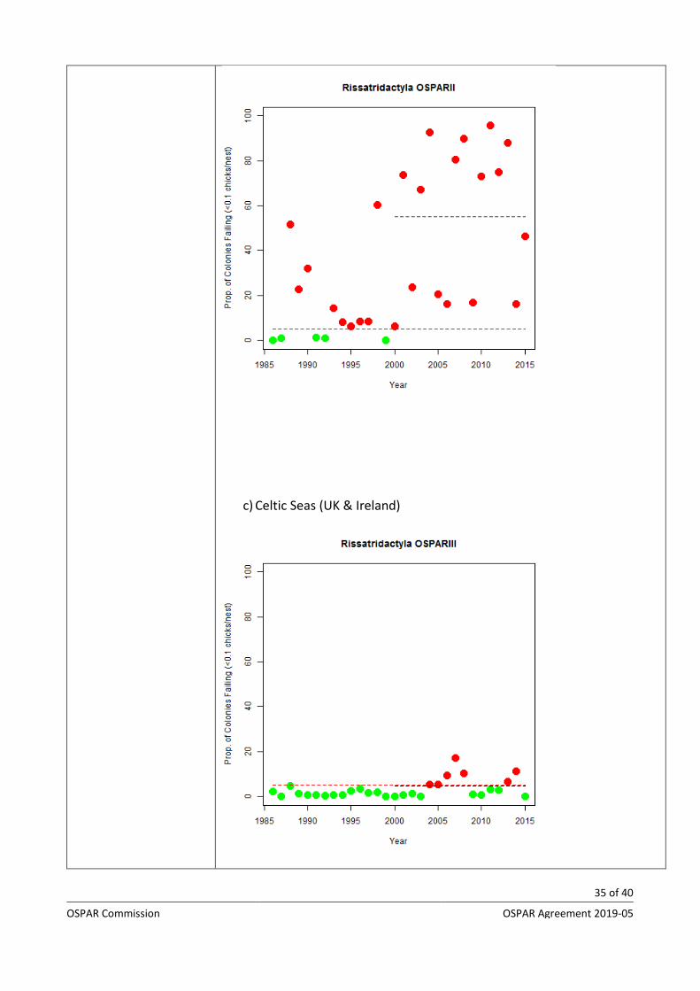
Breeding failure in kittiwake occurred in just over 5% of monitored colonies in the Norwegian part of Arctic waters region in consecutive years during 2007-2015 (figure 3a). Failure has been much more widespread along the UK coast of the Greater North Sea and has occurred in most years since 1986 (Figure 3b). In the Celtic Seas, more than 5% of monitored colonies failed during 2004-08, but only twice since 2009 (Figure 3c).
a) Arctic Waters (Norway)
b) Greater North Sea (UK only)
35 of 40
OSPAR Commission OSPAR Agreement 2019-05
c) Celtic Seas (UK & Ireland)

36 of 40
OSPAR Commission OSPAR Agreement 2019-05
Figure 3: Rates of annual failure of kittiwake colonies between 1986 and 2015. Assessment values are shown as red dotted lines. The assessment value for kittiwakes is 5% of colonies failing per year. The black dotted line denotes the mean percentage of colonies failing per year, over the preceding 15 years.. All values below the assessment value are coloured green and all those above are coloured red and indicate ‘widespread breeding failure’. (Source: OSPAR 2017b)
Method of assessment: 1a, – Source: IA2017,
Threats and impacts
- 100 words
This section should provide information on the key threats to the species/habitat and whether and how they are changing over time, especially any threat that provided the justification for including the species or habitat in the OSPAR list. Particular attention should be given to changes in pressures from human activities since the last assessment or inclusion on the list.
What is the outlook (prospects) for the relevant pressures and human activities over the next 6 years/next 12 years? Are changes to pressures/human activities likely to pose a risk to the long-term viability of the species?
Example:
Threats from climate change appear to be continuing in all regions, although causes of change in Bay of Biscay are unknown. Climate change effects appear to be impacting the food supply of kittiwakes. Kittiwakes and other surface-feeding species have shown greater declines in breeding numbers and more frequent widespread breeding failures in the Greater North Sea than pelagic-feeding species that also feed on fish, but can dive below the surface to catch prey at a variety of depths. This suggests that it is not sheer abundance of prey that is affecting the productivity and breeding numbers of kittiwakes, but the availability of the prey at the surface.
Threats from sandeel fishing in the North Sea still exists in some areas. But the pressure from sandeel fishing in the North Sea appear to be decreasing due to a combination local closures and to reduction in sandeel stocks and fishing effort.
Measures that address key pressures from human activities or conserve the species/habitat
- 100 words
Identify key conservation measures through OSPAR or other organisations, their purpose and whether these are known to be effective in improving the status of the species/habitat.
(i) Provide summarised information on implementation status of OSPAR measure.
Example Based on OSPAR implementation overview assessment reports:
France, Germany, Iceland, Norway, Spain, and the UK have introduced national legislation

37 of 40
OSPAR Commission OSPAR Agreement 2019-05
Germany, Iceland, Norway, and the UK have taken relevant conservation measures in key areas
France and Germany both have six MPAs for black-legged kittiwake
(ii) Highlight any actions that are taken beyond the scope of the OSPAR measure e.g. by other competent authorities OR to address threats to the species outside the OSPAR area
Conclusion (including management considerations)
- 250 words
This section should provide clear conclusions from the assessment. Issues of relevance:
- an overall summary of the status of the species whether this appears to be improving or deteriorating
- whether the assessment brings out implications in relation to the listed species or habitat meeting the Texel-Faial criteria that should receive further consideration
- confidence of the above statements - comments on management (taking note of Annex V Article 4) - indicate whether a re-assessment could be on a short-term/long-
term (e.g. 2/6/10 year) cycle based on the anticipated availability of evidence base
Knowledge gaps (brief)
- 100 words
Brief description of any gaps in knowledge e.g. science gaps.
- sufficiency of data - expert judgement - changes in relation to natural variability When describing knowledge and science gaps describe what work or studies would be needed to fill the gaps.
References

38 of 40
OSPAR Commission OSPAR Agreement 2019-05
(explanatory notes associated to rows above, if the category is indicated for : Method used)
Main source of information:
1. OSPAR data assessment only 2. Assessment derived from third party assessment 3. Assessment derived from a mix of OSPAR data assessment and
assessments from third parties Assessment is based upon:
a) complete survey or a statistically robust estimate (e.g. a dedicated mapping or survey or a robust predictive model with representative sample of occurrence data, calibration and satisfactory evaluation of its predictive performance using good data on environmental conditions across entire species range);
b) based mainly on extrapolation from a limited amount of data (e.g. other predictive models or extrapolation using less complete sample of occurrence and environmental data);
c) based mainly on expert opinion with very limited data; d) insufficient or no data available.
AUDIT TRAIL
(Optional. No word limit)
Additional Evidence and Information
Please insert below any relevant additional evidence and information that provides essential background and rationale to the assessments above.
Include citations of the sources of evidence and information and provide full references in the relevant section below
The audit trail is not published as part of the assessment. It is archived for future reference purposes. The assessment in the rows above needs to be written so that it can be read without accessing information in the audit
trail.
Assessment methods
(additional information, in particular how the overall assessment in the summary table was reached)
Geographical range and distribution (additional evidence & information)

39 of 40
OSPAR Commission OSPAR Agreement 2019-05
Population/abundance (species)
(additional evidence & information)
Condition
(additional evidence & information)
Threats and impacts
(additional evidence & information)
Measures that address key pressures from human activities or conserve the species/habitat
(additional information)
Knowledge gaps (additional information)
References
Additional Guidance for completion
Figure/Table naming
- The numbering of the figures/tables/formulae/charts etc. will follow a Figure 1, Figure 2, Figure 3, etc. structure.
Data snapshot
- All data and any associated coding or script that have been applied to the data in order to run the assessment must be supplied in the final assessment package. These can be supplied in the native format, e.g. spreadsheets, databases, R code, Visual Basic script, in a single zip file, following the prescribed naming convention. This is required for transparency and forms part of the audit trail.
Figures – as images
- All supplied figures and supporting files must follow the described naming convention. To be supplied to the Secretariat in a zip file.
Photos – as jpeg
- A minimum of 2 photographs should be supplied and all photos must be fully accredited with permission for publication and online use. If no accreditation is necessary, please make this clear. Images must be at a resolution of 300dpi and in jpeg format – screenshots are not suitable.

40 of 40
OSPAR Commission OSPAR Agreement 2019-05
Graphs – as jpeg
- All graphs need to have clear, brief titles and be provided as a high-resolution jpeg. All data used to make the graph must be supplied in Excel or readily accessible format.
Formulae – as jpeg
- For example
Tables – as Excel file
- All tables need to have a clear, brief title. All data used to make the table must be supplied in Excel or readily accessible format
Infographics - as jpeg
- All infographics need to have a clear, brief title and be provided as a high-resolution jpeg. All information used to make the infographic must be provided in a suitable and accessible format
Maps – as jpeg
- All maps need to have a clear, brief title. All background data used to make the maps, such as shapefiles, need to be supplied in the assessment snapshot data package
Use of language
- Scientific names – Scientific names can be used to describe the species or habitat, provided the common name is referenced in the first instance it is used. Otherwise try to avoid using scientific names but if this is not possible, be consistent e.g. do not use scientific names in tables and common names in text. In translating between scientific and common names use the World Register of Marine Species, available from http://www.marinespecies.org/.
- Avoid acronyms or explain them – avoid the use of acronyms in the summary text, in the extended text they can be used but written in full in their first instance.
Referencing
- No citations should be used in the 2-page assessment sheets; however, they can be used in the extended online version and in underlying assessments. In the extended online version references should be placed at the end of the appropriate section using the following layouts for peer reviewed and grey literature publications respectively:
o Author, X.Y., Date YYYY, Title. Organisation or Journal, Location, Number of pages (e.g. 123 pp) or pages (12-15)
o Title. Organisation, Location, date YYYY. Publication Ref. Number of Pages