Embed Size (px)
Citation preview

1
GUIDE FOR APPLICATION
OF THE NEWFOREST LAWTO RURALPROPERTIES
2nd Edition
REVISED AND
EXPANDED

2

3

4

5
Prepared by:Imaflora - Institute for Forest and Agricultural Management and CertificationIPEF - Institute for Research and Forestry Studies
Authors:Maria José Zakia (IPEF) and Luís Fernando Guedes Pinto (Imaflora)
Maps:Amanda Cotelesse Souto (Imaflora)Elisa Vieira Hardt (Imaflora)Maria Fernanda do Prado
Photos:Casa da Floresta and Imaflora collections
Revision:Raul Silva Telles do Vale (Instituto Socioambiental)Tasso Rezende de AzevedoMariana Aparecida Carvalhaes (Embrapa Center-North)
This material does not necessarily reflect the revisers’ opinion.
Acknowledgments:Ricardo Resende Barbosa (Torrão de Ouro Farm)Marcelo Resende Barbosa (Florestando)Fábio Fernandes Corrêa (Environmental District Attorney - Teixeira de Freitas/BA) and Roberta del Giudice (BV Rio)Victor Eduardo Lima Ranieri (EESC / USP)
Layout: 4 Talentos Advertising Agency
Translated by:
Cataloguing data:Guide for application of the new forest law to rural properties – 2nd edition, revised and enlarged/ Maria José Zakia, Luis Fernando Guedes Pinto. - Piracicaba, SP: Imaflora, 2014. 36p.
ISBN: 978-85-98081-63-2
1. Agriculture and related technologies. 2. Environmental Legislation
This license does not cover photos and illustrations, which remain in copyright.
You may:
• Copy, distribute, exhibit, and execute this work;
• Create derivative work.
Under the following conditions:
• Credits. Credit must be given to the original author, as specified by the author or licensor.
• Non Commercial Use. You may not use this work for commercial purposes.
• Sharing under the same License. Should you change or create another piece of work based on this one, you may only distribute the resulting work under an identical license.
To distribute the contents published by Imaflora in a more democratic manner, its publications are under license of Creative Commons (www.creativecommons.org.br), which treats intellectual property issues more flexibly. In practice, this license enables texts to be copied and this work to be used, provided a few requirements are met: no commercial purpose should be involved; original source must be mentioned (including the text’s author); and derivative works must be licensed with Creative Commons.
O Imaflora® (Institute for Forest and Farm Management and Certification) is a not-for-profit Brazilian organization, established in 1995 to promote conservation and a sustainable use of natural resources, and to generate social benefits in the forestry and farming industries.
Estrada Chico Mendes, 185 | Cep: 13426-420 | Piracicaba | SP | BrazilPhone/Fax no.: (19) 3429.0800 | [email protected] | www.imaflora.org.br
Advisory Board:Marcelo PaixãoMarilena LazzariniMário MantovaniFábio AlbuquerqueRubens Ramos Mendonça
Executive Secretariat:Maurício VoivodicEduardo Trevisan Gonçalves
Board of Directors:Adalberto VeríssimoAndré Villas-BôasCélia CruzMaria Zulmira de SouzaSérgio A. P. EstevesTasso Rezende de AzevedoRicardo Abramovay
Audit Committee:Adauto Tadeu BasílioErika BecharaRubens Mazon
Communications:Priscila MantelattoJaqueline LourençoBeatriz BorghesiFátima Nunes

6
TABLE OF CONTENTS
INTRODUCTION
INTRODUCTION TO THE SECOND EDITION
WHAT LAW IS THIS?
CLASSIFICATION OF RURAL PROPERTIES FOR LAW APPLICATION PURPOSES
A FEW DEFINITIONS FOR LAW APPLICATION PURPOSES
AREAS OF PERMANENT PRESERVATION (APPS)
LEGAL RESERVE (RL)
REGULARIZING RURAL PROPERTIES ACCORDING TO TRANSITIONAL RULES
APPS IN WATER RESERVOIRS
ABOUT CAR – ENVIRONMENTAL RURAL REGISTRY AND PRA – ENVIRONMENTAL REGULATION PLAN
A LAW INNOVATION – ECONOMIC INSTRUMENTS TO HELP CONSERVATION IN PRIVATE LAND
PRACTICAL CASES
ADDITIONAL MATERIALS
05
06
07
09
11
16
20
23
30
31
32
33
36
1
2
3
4
5
6
7
8
9
10
11

7
INTRODUCTION
The main object of this publication is to help implement the New Forest Law in our country. Brazil has laws to address protection, conservation, the possible removal, and use of forests in private areas at least since 1965. However, despite successive changes and attempts to adjust to the passing of time, the Forest Code has unfortunately been continually disrespected, poorly enforced by the Brazilian government, and even less complied with by the country’s farming and cattle ranching industry.
Brazil’s farming and cattle raising industry is one of the pillars of its economy, as the country is a major producer and exporter of foods, fibers, and biofuels. Brazil also has the world’s largest forest coverage, in addition to its enormous biodiversity which makes the country a provider of environmental services, and one of the biggest reserves of runoff and underground fresh water in the planet. Everyday we learn some more about the importance of forests and biodiversity, not just for the planet’s health, but also for the maintenance of humankind and growth of the world’s economies, as well as for our own farming and cattle raising production. The largest part of the Brazilian forests, which are present in the entire national territory and different biomes (the Amazon, Caatinga, Cerrado (Savana - tropical savannah zone), Mata Atlântica (Atlantic Rainforest), the Pampas, and Pantanal regions), is in private land. Of the 537 million hectares of Brazil’s forests, 365 million (68%) are outside areas of public protection.
After a long and disorderly revision process, a New Forest Law was passed in 2012. In general terms, it kept forest protection in rural properties. The fundamental concepts of Area of Permanent Preservation (APP) e Legal Reserve (RL), were maintained. With a few exceptions, APP and RL compliance requirements were also maintained. Therefore, the expansion of new production areas must contemplate forest protection. However, legal compliance has become lax with regard to new ways of accounting for RL and APP areas and compensating RLs, particularly as a result of property size. Finally, substantial changes occurred for the adequacy of non-complying areas – which should be adjusted by July 22, 2008.
IMAFLORA and IPEF got together to explain the New Forest Law to farmers and to other active Brazilian organizations in the rural area. This Guide introduces the main concepts, definitions, and requirements of the new Law. Our expectation is that the law is understood and implemented, to accomplish its aim of contributing to Sustainable Development.Piracicaba, November, 2013
Maria José Zakia (IPEF) and Luís Fernando Guedes Pinto (Imaflora)

8
INTRODUCTION TO THE SECOND EDITION
The second edition of this Guide is meant to improve its content as well as knowledge of the Forest Law by the public who must understand it, if it is to put it in practice in the country. In the first edition, demand exceeded our expectation, and showed the huge Brazilian interest in understanding the Forest Code and the requirements to comply with it. It also confirmed the shortage of simple materials and objectives, thus the translation of the Law for its target audience.
A few weeks after publication of its first edition, the Guide had more than 245,000 visits to Imaflora’s website, over 30,000 visits to IPEF’s website, and generated over 150 news stories on TV, radio, rural community specialized media, in addition to the general media. Little by little, we started hearing from users, partners, and colleagues about parts of the publication that did not seem entirely clear to them, or needed more clarification for a better understanding.
This new edition was revised with this purpose in mind, focusing on separating the rules under the new Forest Law, which are permanent, from those rules that apply to deforestation cases before July, 2008.
The second edition will be jointly released with an application for tablets and internet browsers. It will be a Forest Law simulator, where farmers can enter their property data and see the law applied to their own reality, with blank spaces and steps to comply with the law; a forest deficit of surplus, among other functions.
In short, this Guide was prepared to support implementation of the Forest Law in the country. It is not the intention of this Guide to analyze or discuss the Law in its legal aspects, or potential interpretations of its more complex Articles. This contribution deserves other materials, and we encourage their development as they may advance the Law. The materials do not go into much detail about state laws. The object is to show the main structure on which they should all be based.
Maria José Zakia (IPEF) and Luís Fernando Guedes Pinto (Imaflora)
April 28, 2014.
PLEASE NOTEThe second edition of this guide will be distributed in electronic
form and in hard copy. It therefore has several links, signaled
throughout the publication with a icon , which directs the
reader to additional information. The links are also indicated
on the hard copy, so that the reader knows there is additional
material available in the electronic version, which may be
accessed on the Imaflora and IPEF websites.

9
WHAT LAW IS THIS?Since May 28, 2012, a new forest law has been in force in Brazil: Law 12651.
It was changed in a few places, first by a Provisional Measure, and, in October, 2012, by Law 12727.
The new forest law provides for native vegetation protection; alters Laws nos. 6938/19811 - 9393/19962, and 11428/20063; and revokes Law no. 4.771/19654 and all its alterations.
In its Article 1 the law lays down its object – or “its mission” – which is, in this case:
To set up general rules to protect vegetation, areas of Permanent Preservation, and Legal Reserve areas; forest exploitation, raw material forest supply, the controlled origin of forest products, and the control and prevention of forest fires. It also includes economic and financial instruments to achieve its purposes. In the same article, the Sole Paragraph highlights one of the aims of the law: a Sustainable Development.
To implement the Forest Law, it is important to consider the existing environmental legal system which encompasses the new Forest Law. (Picture 1) This legal system is aimed at regulating the use of the land, and the conservation of forests and other natural resources of Brazil, complementing other laws and regulations. Its application should take these other instruments into account, as, for example, Lei da Mata Atlântica, or the Atlantic Rainforest Law.
1. National Environmental Policy2. About ITR3. Lei da Mata Atlântica
4. Forest Code5. About Public Records
1
GOOD TO KNOW!
Sustainable development is a kind of development capable of meeting the current generation’s needs, without compromising its ability to meet the needs of future generations. It’s a development that does not deplete resources for the future.
This definition came up at the World Commission on Environment and Development, created by the United Nations to discuss and propose ways of harmonizing two objectives: economic development and environmental conservation.
Source: www.wwf.org.br
GOOD TO KNOW!
General Rule - A rule that contains broader guidelines on a subject matter. Here, the law provides guidelines to be followed all over the country, aimed to protect forests. But this does not prevent states, municipalities, and the Federal District from having their own forest laws, which must be as strict as the general rule, if not stricter.

10
THE FEDERAL CONSTITUTION
PERMANENT RULES
TRANSITIONAL RULES
National Policy on Water Resources (1997)
Water Code (1934)
Fauna Code (1967)
Forest Law(2012)
SNUC – National System of Conservation Units (2000)
Lei da Mata Atlântica (2006)
Public Forest Management Law (2006)
Article 186Social Function of Rural Properties
1. Productive properties that complied with the old Forest Code rules;
2. Properties not yet
exploited; 3. Properties illegally
deforested after July 22, 2008.
Property which use APPs before July 22, 2008, with buildings, improvements or agricultural and forestry activities. In the latter case, the adoption – or not – of a fallow system has its RL percentage as laid down by law.
Article 225Chapter on the Environment
Rules of procedure
The APP cannot be used to calculate an RL (but generates surplus.) There is no consolidated use in any kind of APP
The APP can be included in the RL calculation.The duty to restore is different according to property size.
Material rules
Water Fauna Flora
Law 6938/81 Environmental Zoning and Licensing
Law 9605/98 Penalties for breaching material rules
Picture 1 – Environmental Legal System (partial) applied to rural land.Adapted from work created by Luís Carlos Silva de Moraes. Environmental Law Course.
The law also establishes different rules for consolidated use, APP and/or Legal Reserve, or restricted-use properties before July 22, 2008. At such properties, the duty to restore, as well as the ability to keep their consolida-ted use, is different from one rural property to another, due to their individual sizes.
To enable the reader to better understand how it all works, we show the rules as permanent and transitional, as below.
Additionally, and for better understanding, there’s a sign throughout the text to draw the reader’s attention to points that are relevant to those properties under consolidated use prior to July 22, 2008.
PLEASE NOTEData registration at CAR should not take longer than one year, counting from May 5, 2014.

11
As the reader will see throughout this publication, the law defines areas in rural properties that must be protected and kept with their native vegetation. These are: (I) Areas of Permanent Preservation (APPs), which must be protected due to their physical and/or ecological fragility, with their location set according to the rural properties’ physical and geographic features; (II) Legal reserves (RLs), which are a percentage of the property’s area which must preserve the native forest cover to support biodiversity conservation, along with the APPs. For this reason, their property allocation is more flexible, as they do not depend on purely geographic aspects; (III) Areas of restricted use and forest remnants.
The Law defines whether and how interventions may occur in the properties’ forest and native vegetation areas. These interventions may consist of management, exploitation, and removal. The law also defines ways to identify areas that do not comply with the rules, and the mechanisms and instruments to adapt properties through restoration, compensation, or other means the Law provides.
CLASSIFICATION OF RURAL PROPERTIES FOR LAW APPLICATION PURPOSES
2
This guide addresses the application of Forest Law to rural properties. Therefore, the first step is determining whether the property is rural or urban. If subject to ITR (Territorial Rural Tax), the property is rural, even if located within urban expansion limits.
And this law has different applications depending on rural property size. According to Brazilian rural legislation, rural property may be:• Mini-rural properties: any rural property whose area is smaller than
one (1) fiscal module;• Small rural properties: any rural property of between one (1) and four
(4) fiscal modules in area;• Mid-size properties: any rural property area of four (4) to 15 (fifteen)
fiscal modules;• Large properties: any rural property area of more than fifteen (15)
fiscal modules.
The fiscal module is established per individual municipality, and is aimed to reflect the mean area of Rural Modules of the municipality’s rural properties. For compliance with this law, property size will be considered its size on July 22, 2008.
Rural property is an area formed by one or more property registration numbers (matrículas) of continuous land in the name of a same holder (whether owner or legal holder). The property may be located in the municipality’s rural or urban area

12
A fiscal module is a land measuring unit in Brazil, established by Law no. 6746 of December 10, 1979. It is expressed in hectares, is variable, and set for each municipality according to:
• Kind of exploitation prevailing in the municipality;• The income brought in by the main exploitation business;• Other existing exploitation businesses in the municipality which,
even if not prevailing, are significant for the income they bring, or the area they use;
• Concept of family property.
A fiscal module should not be confused with a rural module.
A fiscal module equals the minimum area required for a rural property to run a viable exploitation business. Depending on the municipality, a fiscal module may vary from 5 to 110 hectares. In metropolitan regions, a rural module is usually quite smaller than in rural areas farther away from major urban centers.
A fiscal module also serves as a standard to define beneficiaries at PRONAF (small family farm producers, owners, sharecroppers, legal holders, partners, or tenants of up to four (4) fiscal modules.)
WHAT IS A FISCAL MODULE?
WHAT IS A RURAL MODULE?A rural module is calculated for each rural property, and its area reflects the kind of exploitation or utilization prevailing in the rural property.
WANT TO KNOW ABOUT FISCAL MODULES IN YOUR MUNICIPALITY?
What typifies a rural property in the eyes of rural legislation is its “farming, cattle breeding, and forestry, or agribusiness purposes.” Law no. 8629 of February 25, 1993, article 4, item I).
The phrase continuous areas means confronting areas in the same holder’s name. Such areas are considered a sole property, even if each area has its own property registration number, and even if there are physical disruptions such as roads, watercourses, etc, provided their utilization is the same.
Source: http://www.incra.gov.br/index.php/servicos/fale-conosco/perguntas-frequeentes
13
Both the new forest law and Decree no. 7830 have laid down essential definitions to understand and apply the law. In this guide, we will transcribe those we consider essential for APP and Legal Reserve delimitation and restoration.
The Legal Amazon area: the States of Acre, Pará, Amazonas, Roraima, Rondônia, Amapá, and Mato Grosso, plus the regions to the north of parallel 13 S of Tocantins and Goiás States, and to the west of meridian 44 W of Maranhão State. See the map
Area of Permanent Preservation, APP: a protected area, covered or not by native vegetation, with its environmental functions of preserving water resources and the landscape, geological stability and biodiversity, improving the fauna and flora gene flow, protecting the soil, and ensuring the well-being of human populations.
Legal Reserve: an area located within a property or a rural possession, under the terms of article no. 12, with the purpose of ensuring the economic and sustainable use of the rural property’s natural resources, keeping and restoring ecological processes, and promoting biodiversity conservation, which includes shelters, and protection of wild fauna and native flora.
Consolidated rural area: a rural property area occupied by human beings, existing prior to July 22, 2008, with its buildings, improvements, or agricultur-al and forestry activities, which may include a fallow system.
AREAS OF RESTRICTED USE
1. Pantanal areas and plains, and areas where ecologically sustainable exploitation is allowed, and where technical recommendations from official research authorities must be observed. New removals of native vegetation for alternative use of the soil will depend on approval of the state’s environmental authority.
2. Slope areas between 25 and 45 degrees where sustainable forest management and farming, cattle breeding and forestry activities are allowed, as well as the maintenance of the physical infrastructure connected to the development of these activities, provided good agricultural practices are observed. The conversion of new areas is forbidden, except when declared of public interest.
A FEW DEFINITIONS FOR LAW APPLICATION PURPOSES3
HOW DID IT WORK UNDER THE PREVIOUS LAW?
Legal Reserve: an area located inside a rural property or possession, except those of permanent preservation, required for the sustainable use of natural resources, conservation, and recovery of ecological processes, biodiversity and shelter conservation, and protection of native fauna and flora.
Area of Permanent Preservation: a protected area as per articles nos. 2 and 3 of this Law, whether or not covered by native vegetation, with the purpose of preserving water resources, the landscape, geological stability, biodiversity, the fauna and flora gene flow, protecting the soil, and ensuring the well-being of human populations.WHY IS JULY 22, 2008 THE CUTOFF DATE?
This is the date of approval of Decree no. 6514, which addresses environmental violations and administrative penalties, and regulates the Law of Environmental Crimes published in 1998.

14
Small rural family property or possession: a property exploited through personal efforts of family farmers and rural family entrepreneurs, including the settlements and land reform projects in compliance with article no. 3 of Law no. 11326 of July 24, 2006.
PLEASE NOTE
For law application purposes, the same treatment is given to:• Family farming;• Properties of up to 4 fiscal modules that develop agricultural
and forestry activities;• Demarcated indigenous lands;• Other areas to which traditional peoples and communities
are entitled.
COMPARING APP LIMITS COVERED BY THE NEW LAW AND THE OLD FOREST CODE
Regular river bed
ENVIRONMENTAL MANAGEMENT VS. LEGAL COMPLIANCE
Legal compliance should not be confused with environmental management. Compliance with legislation is a required action, but it is not sufficient to cover environmental management and the adoption of good rural practices.
Laws cannot be expected to contemplate every situation of environmental fragility which may occur in a rural property. Therefore, special attention should be given to conservation of the so-called wet areas, such as intermittent springs, for example.
Although the forest law does not provide for the mandatory protection of intermittent springs, it is recommended that rural property owners or holders do their best to protect such areas.
Spring: an outflow of natural and permanent groundwater forming a watercourse. See kinds of spring
Regular bed: a bed in which a watercourse regularly runs all year round.

15
Vereda: the phytophysiognomy of a savannah found in hydromorphic (frequently wet) soils, usually alongside narrow water courses and with typical buriti palms (Mauritia flexuosa) that do not form a canopy, and groups of shrubs and herbaceous vegetation;
Mangrove: a coastal eco-system occurring on lowlands, subject to tides, formed by recent sludge or sand, with predominant natural vegetation, influenced by freshwater and seawater, known as mangrove. It is typical of slimy soils found in estuary regions, with a discontinued distribution alongside the Brazilian coast, between Amapá and Santa Catarina States;
Restinga: a longish sandbank parallel to the coastline, produced by silt processes, where different sea-influenced communities covered by vegetation in mosaic form are found. These can be found on beaches, sandy bars, dunes, and depressions, with typical species according to their successional stage, which may be herbaceous, shrubs, and trees, the latter farther away from the coast;
Hills, mountains, and mountain ranges: elevations with a minimum height of one hundred (100) meters from foot to peak and an average or mean slope of more than 25 degrees. (This definition is not in article 3 of the Forest Law, but was taken from article 4. Item IX)
Foothills, foot of mountains, and mountain ranges: flat ground formed by a plain or an adjacent pond or, in the case of an undulating relief, by the saddle point quota closest to the foot; (this definition is not in article 3. of the Forest Law, but was taken from article 4. Item IX)
Wetlands: swampland and surfaces covered by water from time to time. Originally covered by forests or other kinds of flood-adapted vegetation;
The Environmental Rural Registry System – SICAR: a nationwide electronic system aimed at managing rural property environmental information.
The Environmental Rural Registry – CAR: a nationwide electronic registry kept by the proper environmental authority under the National Environmental Information System (SINIMA), which is mandatory for all rural properties, with the purpose of integrating environmental information on rural properties and possessions, creating a database for environmental and economic control, by monitoring, planning, and preventing deforestation.
Term of commitment: a formal document of adherence to the Environmental Regulation Program – PRA, containing at least the commitment to keep, recover and restore a rural property’s areas of permanent preservation, legal reserves and restricted use, or compensate legal reserve areas.
Area with native vegetation remnants: an area with native vegetation in its primary stage, or advanced secondary stage of regeneration.
Degraded area: an area that has been affected by human activities to an extent that prevents its natural regeneration.
Affected or impacted area: an affected area that is still capable of natural regeneration.
Abandoned area: a production space converted into soil for an alternative use, without any productive exploitation for at least thirty-six months and not officially in a fallow system.
Anthropic areas: areas which are degraded or affected by human activities.

16
Restoration: the recovery of an eco-system or native biological community from a degraded or impacted condition to a non-degraded condition, which may be different from its original condition.
THE MISSING DEFINITION!
Forest: A piece of land of at least 0.5-1.0 hectare with a tree crown coverage (or equivalent stock level) of 10 to 30%, or more, trees with the potential to reach a minimum height of 2 to 5 meters in their in situ maturity. A forest area may consist of dense forests or thickets, where several strata and understory trees cover a large part of the soil. Or it may be an open forest. Natural populations, young plants or planted trees that still have to reach a crown density of 10-30 percent or the height of a 2-5 meter tree are considered forests, as well as those areas that are temporarily stockless, as a result of human intervention, and which are normally part of the forest. Such intervention includes harvesting or natural causes, but hopefully the forest will be restored (definition established during the Marrakesh Meeting, to be employed for land use activities, changes in the use of the land, and forests, as per Article1.3, paragraphs 3 e 4, of the Kyoto Protocol).
Blueprint: a flat graphic representation in a minimal scale of 1:50.000, containing natural and artificial details of the rural property.
Sketch: a simple draft of the rural property’s geographic situation with its native vegetation remnants, easements, areas of permanent preservation, areas of restricted use, consolidated areas and location of the legal reserves, based on the geo-referenced satellite image, provided by SICAR.
Native vegetation remnants
Restoration

17
A FREQUENT QUESTION: WHAT IS THE CONNECTION BETWEEN A THALWEG AND A WATERCOURSE?
Thalweg defined – the line of lowest elevation in a watercourse or valley. It results from the intersection of slopes with two converging slope systems.
Source: Glossary of geological and environmental terms applied to geosciences / Jorge Gomes do Cravo Barros. - Brasília: ESMPU, 2006.138 p.
In other words, thalweg is not synonymous with perennial or intermittent watercourse. Watercourses should have APPs.
The beginning of a thalweg does not always coincide with a spring.
Fallow: a practice of temporary interruption in farming, cattle ranching or forestry activities for a maximum period of five years, to enable the soil to recover its capacity or its physical structure.
Perennial river: a moving body of water with a natural runoff flow all year long.
Intermittent river: a moving body of water which does not have a natural runoff flow during certain times of the year.
Ephemeral river: a moving body of water with a runoff flow only during, or immediately after, rainy periods.
Environmental regularization: activities that are developed and imple-mented in the rural property to comply with environmental legislation, mainly for the upkeep and recovery of areas of permanent preservation, legal re-serve, and restricted use, and also legal reserve compensation, when ap-plicable.
Farming and forestry system: a system of soil use and occupation where perennial woody plants are managed along with herbaceous species, shrubs, trees, farm crops, and forage, located in the same management unit, according to a spatial and time arrangement, having a high species diversity and interactions among the species.
Restoration project of a degraded and impacted area: a restoration planning instrument in accordance with methodologies, schedules, and inputs.
Environmental Reserve Quota: CRA – a nominal title representing an area with existing native vegetation or vegetation being restored;
Environmental information: information characterizing the perimeters and location of native vegetation remnants, of areas of public interest, APPs, areas of restricted use, consolidated areas, and Legal Reserves – RL, as well as areas being restored, recovered, or regenerated or under compensation;
Area being recovered: an impacted area for agricultural and forestry use whose native vegetation is being restored or recovered in Areas of Permanent Preservation, Restricted Use, and Legal Reserve;
Area of administrative easement: an area declared by the Public Authorities as of public interest, which affects rural properties.

18
AREAS OF PERMANENT PRESERVATION (APPS)
4
The boundaries of Areas of Permanent Preservation are provided in Article 4 of the new Forest Law.
It should be recalled that this Law provides for real estate properties to which transitional rules apply, the ability to maintain farming and cattle breeding activities in APPs, under a few special conditions, which will be further clarified.
For property to which permanent rules apply, all the APPs must be conserved or restored.
I - strips of land alongside any natural, perennial, and intermittent watercourse banks, except ephemeral ones, from the edge of the regular bed with a minimum width of:
a) Thirty (30) meters for watercourses less than ten (10) meters wide;
b) Fifty (50) meters, for watercourses with a width of ten (10) to fifty (50) meters;
c) One hundred (100) meters, for watercourses measuring fifty (50) to two hundred (200) meters in width;
d) Two hundred (200) meters for watercourses measuring two hun-dred (200) to six hundred (600) meters in width;
e) five hundred (500) meters for watercourses with a width of more than six hundred (600) meters.
WATERCOURSE
ART. 4. THE FOLLOWING ARE CONSIDERED AREAS OF PERMANENT PRESERVATION, BOTH IN RURAL AND URBAN ZONES:
ART. 4. THE FOLLOWING ARE CONSIDERED AREAS OF PERMANENT PRESERVATION, BOTH IN RURAL AND URBAN ZONES:
II - areas surrounding lakes and natural lagoons with a mini-mum strip of land of:
a) One hundred (100) meters, in rural zones, except for a body of water with a surface of up to twenty (20) hectares, whose strip of land alongside its banks will be of fifty (50) meters;
b) Thirty (30) meters, in urban zones.

19
RESERVOIR
III - the areas surrounding dams (artificial reservoirs from natural watercourses) within the strip of land defined in the enterprise’s environmental license.
Para. 4. In the natural or artificial water collection with a surface of less than one (1) hectare, there is no need to restore the APP, but removing new areas of native vegetation without authorization is prohibited.
IV - the areas surrounding perennial and intermittent springs, regardless of their topography, within a minimum radius of fifty (50) meters.
ART. 4. THE FOLLOWING ARE CONSIDERED AREAS OF PERMANENT PRESERVATION, BOTH IN RURAL AND URBAN ZONES:
ART. 4. THE FOLLOWING ARE CONSIDERED AREAS OF PERMANENT PRESERVATION, BOTH IN RURAL AND URBAN ZONES:
Natural Lakes and Lagoons
Dams created by damming
watercourses (and not for AP
or GEE)
Dams created by damming
watercourses for AP or GEE
Water areas APP width APP width APP width
Up to 1 ha 0 m 0 m
30 m minimum and 100 m
maximum, as per license
Over 1 ha and up to 20 ha 50 m
Defined by the license
Over 20 ha 100 m
AP = Public Water SupplyGEE = Electric Energy Generation

20
MESA
V - slopes or parts of them with an inclination of more than 45 degrees, equaling one hundred percent (100%) at its steepest point;
VIII - the edges of a mesa down to its foot, within a strip not narrower than one hundred (100) meters on horizontal projections;
IX - at hilltops, mountain tops and range tops, at least 100 meters tall, with a mean slope of over 25 degrees, delimited from the contour line equaling two-thirds (2/3) of the minimum elevation point vis-à-vis the foot, with the foot horizontally defined, and determined by an adjacent plain or pond, or, in the case of undulating reliefs, by the saddle point quota closest to the elevation;
X - areas higher than eighteen hundred (1,800) meters, regardless of their vegetation.
HILLS, MOUNTAINS, AND SLOPES
HOW TO DELIMIT HILLTOPS
ART. 4. THE FOLLOWING ARE CONSIDERED AREAS OF PERMANENT PRESERVATION, BOTH IN RURAL AND URBAN ZONES:

21
XI - in veredas, the strip of land alongside river banks, on a horizontal projection, with a minimum width of fifty (50) meters, measured from the permanently marshy and flooded area.
VEREDA
VI - restingas, as dune fixers or mangrove stabilizers;VII - mangroves, in their full extent.
MANGROVEART. 4. THE FOLLOWING ARE CONSIDERED AREAS OF PERMANENT PRESERVATION, BOTH IN RURAL AND URBAN ZONES:
ART. 4. THE FOLLOWING ARE CONSIDERED AREAS OF PERMANENT PRESERVATION, BOTH IN RURAL AND URBAN ZONES:

22
Every rural property with a Legal Reserve area that is smaller than established, may be regularized, regardless of its adherence to the Environmental Recovery Program – PRA (i.e., it can begin right away.) Compliance with Legal Reserve requirements may be effected in the following cases, which may also be combined:
1. Planting in the property itself;2. Enabling the natural regeneration of vegetation in the Legal Reserve
area of the property itself;3. Compensation of the Legal Reserve in another property or Conservation
Unit.
In restoration cases, phased planting of native species and exotic species or fruit trees may be carried out in a farming and forestry system, provided the following parameters are observed:
I. exotic species should be planted in combination with regional native species;
II. the area restored with exotic species may not exceed fifty percent (50%) of the total area to be recovered.
LEGAL RESERVE (RL)5 The Legal Reserve (RL) is meant to ensure the economic, sustainable use of a rural property’s natural resources, and support its biodiversity conservation. Delimitation of an RL is set forth in articles 12 and 13 of the new Forest Law. Every rural property must keep an area with a native vegetation cover as a Legal Reserve, regardless of the rules applied to Areas of Permanent Preservation (APPs). The following minimum percentages must be observed with regard to the property area:
• When located in the Legal Amazon Area:a) Eighty percent (80%) of a property located in a forest area (in this case, the APP can be included in this percentage);b) thirty-five percent (35%) of a property located in the Cerrado (Savana - tropical savannah) area;c) twenty percent (20%) of a property located in the so-called Campos Gerais area in Paraná State.
For properties in the Legal Amazon area having more than one phytophy-siognomy, the legal reserve delimitation must consider the proportions of each property’s phytophysiognomies, i.e., if a property has half its land in forest and the other half in the cerrado (savana), then the half under forest will have 80% of RL, while the cerrado (savana) half will have 35% of RL.
• Located elsewhere in Brazil:twenty percent (20%).
The above percentages are mandatory for all properties under the permanent rules. In this case, APPs are not included in the Legal Reserve calculation.
For properties where transitional rules apply, APPs may be included in the Legal Reserve calculation, provided that:
a) this does not imply the conversion of new areas for an alternative use of the soil;b) the APP to be included is conserved or undergoing a recovery process;c) the property is included in the Environmental Rural Registry - CAR.
EXAMPLE
A property under transitional rules which must restore 50 ha to meet the property’s Legal Reserve requirements, may do so by combining exotic species with native species. In this combination, the exotic species may not exceed 50% of the area, i.e., 25 ha.

23
PLEASE NOTE
1. The Legal Reserve area may be formed by a group of owners, or be collective among rural properties, with due observance of the percentages set for each property;
2. When dividing rural properties, the Legal Reserve area may be grouped by joint ownership;
3. The Legal Reserve area must be conserved with its native vegetation cover by the rural property’s owner, holder, or tenant, on behalf of an individual (physical person), or legal entity under public or private rights. Where transitional rules apply, native and exotic species may be combined;
4. The Legal Reserve are may be economically exploited, but always through sustainable management, previously approved by the environmental authority;
5. The Legal Reserve area must be registered with the proper environmental authority through its CAR registration number. Its purpose should not be changed in cases of ownership transmission for any reason, or ownership dismemberment;
6. The Legal Reserve’s CAR registration exempts it from being notarized by the Registry of Deeds’ Office. In the period between publication and enactment of this Law and the CAR registration, the rural property owner or holder who wants to proceed with notarization, will be entitled to do it free of charge;
Legal Reserve compensation can be done by:
1. Acquisition of an Environmental Reserve Quota - CRA; 2. Lease of an area under an environmental easement system or Legal
Reserve; 3. Donation to the government of an area located within the Conservation
Unit under public domain that is pending land regularization; 4. Registration of another equivalent area that exceeds the Legal Reserve,
in a property of same ownership or acquired from a third party, with existing native vegetation, or undergoing regeneration or restoration, provided it is located in the same biome.
CAR Registration of the Legal Reserve will be effected by submitting a blueprint and a descriptive memorandum, containing geographic coordinates with at least one lashing point.
In the case of a possession, the Legal Reserve area is ensured by a term of commitment signed by the holder with the proper authorities, containing at least the location of the Legal Reserve area and the obligations undertaken by the holder, under the New Forest Law.
Why 1996? Because November 15, 1996 is the date when the Legal Reserve area in the Legal Amazon was increased from 50% to 80%.
Visit this link to find out the different Legal Reserve percentages in Brazilian Legislation in several time periods (Article 68)

24
7. Exceptions to Legal Reserve percentages in the Amazon area:
a) Enterprises that engaged in deforestation in the Amazon area between 1989 and 1996, within a limit of 50%, are discharged from the obligation to restore up to 80%. If they exceed 50%, this amount can be used for compensation.
b) The percentage may be reduced to 50% if: I) the state has an economic-ecological zoning and over 65% of its
territory occupied by regularized conservation units, or authorized indigenous land, from the State Environmental Council’s standpoint.
II) the municipality has more than half its area occupied by conservation units or authorized indigenous land.
8. Restoration of the Legal Reserve area must take no longer than 20 years, as of the CAR signature, at a rate of 1/10 every other year. Exotic trees may be used to restore up to half the area to be recovered.

25
REGULARIZING RURAL PROPERTIES ACCORDING TO TRANSITIONAL RULES
6
Step 1 - Define whether property is rural or urban.
Step 2 - If rural, find out how many fiscal modules the property contains.
Step 3 - Check property’s category as regards the number ofits fiscal modules. Please note: The area to be considered will be the rural property’s area on July 22, 2008.
This identification is important when defining:
a) Duties regarding the property as regards its Legal Reserve area. In this respect, properties are classified as follows:
• Up to 4 fiscal modules; • More than 4 fiscal modules.
b) Minimum width under mandatory APP restoration. Regarding this item, properties are classified as follows:
• Up to 1 fiscal module; • Between 1 and 2 fiscal modules; • Between 2 and 4 fiscal modules; • Between 4 and 10 fiscal modules; • More than 10 fiscal modules.
FISCAL MODULES PER MUNICIPALITYAll APPs deforested after July 22, 2008, without due authorization, must be entirely restored with native vegetation.
Step 4 - Delimiting all the rural property’s Areas of Permanent Preservation.
Identifying all the rural property’s APPs (regardless of size) on a map, following the limits already set forth in chapter 4. All APPs must be delimited, regardless of their use or current situation. In the event that APPS are co-vered by native vegetation, this should be kept and protected, and may no longer be removed.

26
Step 5 - Delimiting the so-called areas of restricted use.
There are two kinds of so-called areas of restricted use, and their limitations are provided by articles 10 and 11 of the new Law.
Article 10. In swamp areas and plains, ecologically sustainable exploitation is allowed, and technical recommendations from official research agen-cies must be followed. New removals of native vegetation for alternative use of the soil will depend on approval granted by the state’s environmen-tal authority, based on the recommendations mentioned in this article;
Article 11. In slope areas of between 25 degrees and 45 degrees, sustai-nable forest management and farming and forestry activities will be permit-ted, as well as maintenance of the physical infrastructure for those activi-ties, provided good agricultural practices are observed. The conversion of new areas is prohibited, except when deemed to be in the public interest.
IMPORTANT NOTICE
Small rural properties or family possessions, as well as properties of up to 4 fiscal modules, are allowed to grow temporary, short-cycle crops on the strip of land that is exposed during the ebb period of rivers or lakes. But this is done only without cutting off new areas of native vegetation. Crops must also conserve water and soil quality and protect the wild fauna.
GOOD TO KNOW!A 25-degree inclination equals a 46% slope, and a 45-degree inclination equals a 100% slope.
Farming, cattle breeding, and forestry activities plus sustainable forestry management include, among other items, perennial crops such as coffee, cocoa, eucalyptus, slash pine, fruit trees, provided these are all grown with soil and water conservation techniques.
Step 6 - Map all the property’s fragments of native vegetation.
Step 7 - Check the APPs’ use of the soil.
If the APP has been converted without authorization or license prior to July 22, 2008, and its native vegetation cover is smaller than required, the owner or farmer has two options:
I) Restoring the APPs with native vegetation;II) Maintain the consolidated use in part of the APPs and restore only the
mandatory APP areas.III) Only small properties may use exotic species combined with native
species to recover APPs.
27
ABOUT THE CONSOLIDATED USE OF APPS
APPs linked to natural water resources (springs, watercourses, veredas, and natural lakes and lagoons) have a minimum mandatory restoration strip, which varies according to the rural property’s size. The other APPs (reservoirs, slopes, hilltops, mountain tops, mesas, mangroves, restingas, and altitudes above 1,800 meters) do not have a minimum strip of land as a recovery requirement.
The consolidated use of APPs may only continue to exist if practices are applied to ensure water and soil conservation. Such practices will likely be regulated in the future, but depend on the species to be used and general farming practices. The practices which pose the least risk are:
I. Perennial crops without using pesticides or soluble fertilizers in the entire area. The application of herbicides and local fertilizers must be extremely cautious;
II. Planting trees with a low impact harvest, or for non-wood products;
III. In all cases, action should be taken to prevent the consolidated area crop from invading the native area. Roads with poor maintenance and a maximum width of between 5 and 7 meters should have controlled water outlets, without spilling water directly in the watercourse.
High-risk practices that should be avoided in the consolidated APPs:
I. Annual or semi-perennial crops that require plowing or harrowing to prepare the soil;
II. The use of fungicides, insecticides, and soluble fertilizers in the entire area;
III. Heavy machinery traffic, which may bring the risk of soil compaction, restricting the necessary water seepage;
IV. Wide roads with a frequent maintenance and heavy traffic with an
uncontrolled water discharge directly into the watercourse.
The APP part with native vegetation, or being restored, may be considered as RL. However, the APP portion in consolidated use, and therefore unreco-vered, does not count for the Legal Reserve calculation.

28
The APP in the photo has not been managed with soil and water conservation practices, therefore
its consolidated use may be discontinued.
Irregular situation Regularized situation, so consolidated use may continue
PLEASE NOTE:
An APP in consolidated use is not an extension of farming, cattle breeding, or forestry activity areas. On the contrary, it is a production area within an APP, which is a fragile area facing environmental risk, with an ecological function. Therefore, it may require a different type of management from the rest of the productive area. One might say that production within an APP in consolidated use adds to the complexity of the property’s management.
The APP areas in consolidated use must be delimited on the property’s map and at CAR.
WATERCOURSE
APP WITH A CONTINUED CONSOLIDATED USE
APP WITH NATIVE COVER
APP WITH THE MINIMUM MANDATORY STRIP RESTORED
EUCALYPTUS EUCALYPTUS
EUCALYPTUSEUCALYPTUS
WATERCOURSE
APP DELIMITATION
APP WITH NATIVE COVER COFFEE COFFEE
CORN CORN
29
Property Size in Fiscal Modules (M.F)
Up to 1 MF Larger than 1 MF, up to 2 MF
Larger than 2 MF, up to 4 MF
Larger than 4 MF, up to 10 MF
Larger than 10 MF
Watercourse widths
Up to 10 m
5 m 8 m 15 m
20 m 30 m
10.1 m to 60 m 30 m 30 m
60.1 m to 200 m River width /2 River width /2
Over 200 m 100 m 100 m
Property Size in Fiscal Modules (M.F)
Up to 1 MF Larger than 1 MF, up to 2 MF
Larger than 2 MF, up to 4 MF
Larger than 4 MF, up to 10 MF
Larger than 10 MF
Around springs 15 m 15 m 15 m 15 m 15 m
Property Size in Fiscal Modules (M.F)
Up to 1 MF Larger than 1 MF, up to 2 MF
Larger than 2 MF, up to 4 MF
Larger than 4 MF, up to 10 MF
Larger than 10 MF
Around natural lakes and lagoons 5 m 8 m 15 m 30 m 30 m
Property Size in Fiscal Modules (M.F)
Up to 1 MF Larger than 1 MF, up to 2 MF
Larger than 2 MF, up to 4 MF
Larger than 4 MF, up to 10 MF
Larger than 10 MF
Alongside veredas, starting from the soaked area
5 m 8 m 15 m 30 m 30 m
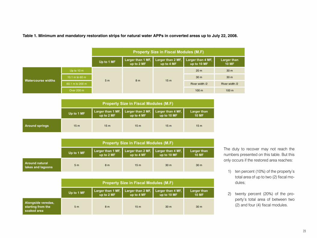
Table 1. Minimum and mandatory restoration strips for natural water APPs in converted areas up to July 22, 2008.
The duty to recover may not reach the numbers presented on this table. But this only occurs if the restored area reaches:
1) ten percent (10%) of the property’s total area of up to two (2) fiscal mo-dules;
2) twenty percent (20%) of the pro-perty’s total area of between two (2) and four (4) fiscal modules.

30
6 There is still an interpretation doubt about how to treat properties without any native fragments.
COMPLIANCE WITH THE LEGAL RESERVE
CAN BE
EXISTING LEGAL RESERVE
(PUBLICITY AND PERPETUITY)
In the property
If the Legal Reserve is in the same property
CAR registration
CRA (Environmental Reserve Quota)
Compensation
If the Legal Reserve is compensated outside the property
In a Conservation Unit
In another property
Lease
Acquisition ofEnvironmental Reserve
Quotas (CRA)
In another property of the same owner
Step 10 - Documenting the existing RL
Step 8 - Assess the need to restore the Legal Reserve.
For rural properties of up to 4 fiscal modules, the Legal Reserve will be repre-sented by the property’s existing fragments6.
Properties with more than 4 Fiscal Modules, whenever the forest cover is smaller than the percentage required for the region’s or the biome’s rural properties (20%, 35%, 50% or 80% - check pages 20 to 22), will be required to restore the Legal Reserve.
Step 9 - Defining ways to comply with Legal Reserve requirements
If it requires restoration, this can be done at the property itself, or made up for (compensated) in another property. Compensation must be mandatorily made in the same biome, in preferably the same State. In this case, it can be done as follows:
• In part of the property, or entirely outside of it – i. e., either the entire Legal Reserve can be compensated, or just the area required to make up the region’s percentage:
• In another property in the same State.
The compensation property needs to be registered with CAR, have a vege-tation cover, or have a CAR-approved PRA, and, if the surplus is registered as an environmental easement, and this easement is used for compensation of another property, then the easement must be notarized along with the property registration number (matrícula) of the properties involved in the tran-saction – i.e., both the property with a surplus and the other property where the decision was to restore the Legal Reserve through compensation.
• In the same State, in Conservation Units (UCs) pending regularization;• In another State, only in a priority area set for conservation.
orSurplus registered with CAR
of same owner’s property
orTerm of area
donation in UC
orLease
Contract

31
PLEASE NOTE:Even if an APP occupies over 20% of the property, it may not be counted as a surplus. See the examples below:
Step 11 - Documenting the existing surplus (applicable only to Native Vege-tation surpluses).
CALCULATING A SURPLUS:
1
2
3
Examples of regions with a 20% legal reserve requirement:
Total native forest (% of property)
APP_12 % RL__20%
APP_20 % RL__12 %
APP_25 % RL__12 %
Surplus
12%32%
32%
37% 12%
12%
DOCUMENTING EXISTING SURPLUS NATIVE
VEGETATION FOR LEGAL RESERVE
COMPENSATION IN ANOTHER PROPERTY
1ª) CAR registration 2ª) Delimitation
of property’s APP and RL
3ª) Delimitation
of surpluses
a Legal Reserve area
or
as an Environmental Easement
orAs RPPN
PLEASE NOTE:
AN ENVIRONMENTAL EASEMENT MAY NOT INCLUDE APPs, and must be notarized with the property’s registration number.

32
APPs IN WATER RESERVOIRS7 The creation of an artificial water reservoir, or a dam, to generate electric energy or public water supply, requires an acquisition, a forced sale, or an administrative easement from the entrepreneur of the Areas of Permanent Preservation created in the dam’s surrounding area. For new dams, APPs should be defined in their licenses and measure 30 meters at least and 100 meters at most when located in a rural zone. To create dams, the entrepreneur must provide an Environmental Conservation Plan and Use of Dam’s Surrounding Area, as provided in the term of reference issued by the proper authorities under the National Environment System – Sisnama. This use may not exceed ten percent (10%) of the total Area of Permanent Preservation.
For enterprises whose bidding processes began when the Law was enacted, an Environmental Conservation Plan and Use of the Dam’s Surrounding Area must be submitted to the environmental office, along with the Basic Environmental Plan, and approved before the enterprise operations start. Its absence does not prevent the enterprise from obtaining its installation license.
For dams aimed at energy generation or public water supply, which were registered or had their concession or authorization contracts signed prior to Provisional Measure no. 2166-67 of August 24, 2001, the extension of the Area of Permanent Preservation will be the distance between the maximum level of normal operation and the very maximum quota
In rural properties of up to fifteen (15) fiscal modules, aquaculture activities are permitted at the APPs, along with their related physical infrastructure, provided that:
I. sustainable practices of soil, water, and water resources manage-ment are adopted to ensure quality and quantity, in accordance with the Environmental State Board rules;
II. it complies with the respective basin plans, or water resources management plans;
III. its license is issued by the proper environmental authority:IV. the property is registered with the Environmental Rural Registry –
CAR;V. it does not imply new removal of native vegetation.
Possibilities of an APP in areas surrounding dams aimed for electric energy generation or
Public Water Supply
Situation 1Licensed before 8/24/2001
APP is mentioned in the license
Situation 3Licensed after
8/24/2001
APP defined in the license
(30 m minimum and 100 m maximum)
Situation 2Built without
a license
Mandatory APP recovery is the area measured from the maximum quota
level of operation to the level of the very maximum quota (Forced Sale Quota)
Dams(Aimed at Electric Energy Generation
or Public Water Supply)
Restoring and caring for the APPs are also part of the Dam Manager’s responsibilities.

33
ABOUT CAR – ENVIRONMENTAL RURAL REGISTRY AND PRA – ENVIRONMENTAL REGULARIZATION PROGRAM
8
VISITS TO WEBSITES1. The national CAR with a link to all the States’ systems
http://www.car.gov.br
2. The PRA decree.
3. The IN about CAR.
PLEASE NOTE:
After October, 2017, financial institutions will only grant agricultural credit to CAR-registered rural properties.
CAR registration is mandatory for all rural properties, and is the main instrument to implement the Forest Law and property regularization by adherence to the Environmental Regularization Program (PRA).
At CAR, all information must be registered on the situation of Areas of Permanent Preservation, Legal Reserve areas, forests, native vegetation remains in Areas
of Restricted Use and consolidated areas in rural properties and possessions in Brazil.
CAR is a tool that contributes toward land use planning and property mana-gement. Registration must be made with the state office, or, in its absence, at the federal system. Regularization must be effected in no more than one year, which can be extended for another year.
Environmental Regularization Programs - PRAs are aimed at regularizing Areas of Permanent Preservation, Legal Reserve, and of restricted use, whi-ch may be conducted through recovery, restoration, regeneration, or com-pensation.
Compensation applies only to Legal Reserve areas — i.e., there is no com-pensation for Areas of Permanent Preservation.
Environmental Regularization Programs - PRAs, include the set of actions or initiatives to be developed by rural owners and holders with the purpose of correcting and regularizing the property. The PRA instruments are:
• The Environmental Rural Registry - CAR;• The term of commitment;• The Project for Restoration of Degraded and Impacted Areas;• Legal Reserve compensation mechanisms, when applicable.
RURAL PROPERTY DATA
Rural Property Name:
Municipality: State:
Geographic coordinates from the center of the rural property
Latitude: Longitude:
Total Area (ha) of Rural Property: Fiscal Modules:
DECLARANT IDENTIFICATION
Name:
MAPS
DECLARED AREAS (in hectares)
Property Area (ha)
Total Property Area (ha)
Administrative easement area (ha)
Net Property Area (ha)
Area of Permanent Preservation (ha)
Area of Restricted Use (ha)
Area with a consolidated use (ha)
Area with Native Vegetation Remains (ha)
Legal Reserve Area (ha)

34
A LAW INNOVATION – ECONOMIC INSTRUMENTS TO HELP CONSERVATION IN PRIVATE LAND
9
To attain its mission of contributing toward a Sustainable Development, the new Forest Law has a principle of “creating and activating economic incenti-ves to promote preservation and recovery of native vegetation and the deve-lopment of sustainable, productive activities.”
Among these incentives, the law specifies payment or incentive to environ-mental services as a reward, whether monetary or otherwise, to conservation and improvement of eco-systems, generating environmental services such as:
a) carbon sequestration, conservation, maintenance and the increase in stock and reduction in flow;
b) conservation of the natural landscape beauty;
c) biodiversity conservation;
d) water and water services conservation;
e) climate regulation;
f) valuing culture and traditional eco-system knowledge;
g) soil conservation and improvement;
h) maintenance of Areas of Permanent Preservation, Legal Reserve and of restricted use.
Such incentives require regulation and actual mechanisms to become effective. However, there are already voluntary cases of payment for environmental services – mainly on the voluntary market of carbon and compensation of Legal Reserves. Voluntary protection is also significant to forest legislation in the form of RPPNs (Private Reserves of Natural Heritage.) According to ICMBIO, there are hundreds of them, totaling more than 480,000 hectares. This is a somewhat modest number, but it could rise significantly with a favorable regulation of the new Forest Law. The message here is that properties with forest surpluses should get financial reward, both through legal reserve compensation and for the environmental services provided by these forests. Additionally, such services may be very important to farm and cattle raising production, as they include pollination, watercourse discharge regulation, water available for irrigation, and a lower incidence of pests and crop diseases, among others. Besides possible bilateral agreements for Legal Reserve compensation with producers, there will be Environmental Reserve Quotas (CRA) and there are already market compensation mechanisms, such as the Rio de Janeiro Green Exchange.(BVRio - http://www.bvrio.org/site/)

35
PRACTICAL CASES101. TORRÃO DE OURO FARM – ATLANTIC RAINFOREST
The Torrão de Ouro farm is located in the Atlantic Rainforest in São Paulo State, and its area amounts to 1,723.44 ha (123.1 fiscal modules). This property’s APPs total 95.36 ha. This accounts for 5.6% of the farm’s total area, although not entirely covered by natural vegetation. Moreover, it has a natural vegetation cover of 695 ha, which accounts for 40.33% of its total area. The following are the steps for the property’s adjustment.
SEE THIS CASE IN GREATER DETAIL
Torrão de Ouro farmSprings, Watercourses, and Dams
Torrão de Ouro farmNatural Water APPs
Areas of Restricted Use
Status of Water APPs
Suggested Conservation Areas
Native Vegetation
Image
Limits established based on Law 4471Suggested location of the Legal Reserve (RL)
Torrão de Ouro farmTorrão de Ouro farmArtificial Water Dams Hilly Ground APPs
Torrão de Ouro farm Torrão de Ouro farm
Torrão de Ouro farm
Torrão de Ouro farm
Torrão de Ouro farm
Torrão de Ouro farm
Property Limits
Dam
Watercourses
Spring
Property Limits
Conserved area
Conserved Area
Property Limits
Spring
Watercourses
Dam
Conserved Area
Suggested protection for area not previously mapped (32.5 ha)
Forest surplus under recovery (33 ha)
Surplus previously unmapped (5 ha)
Forest surplus (194 ha)
Suggested RL location (415 ha)
Area in recovery
Area under recovery
Area under recovery
Suggested conservation area
Area in use
Area in use
Property Limits
Water APP
Water APP
Spring
Property Limits
Property Limits
Watercourses
Dam
Property Limits
Area of restricted use (> 25 degrees and < than 45 degrees) with no APP overlay
Area of restricted use (> 25 degrees and < than 45 degrees) with an APP overlay
Springs 50 m
Watercourses 30 mNatural water APP
93.83 ha of Natural APPs
5.44% of the property’s total area
20.47 ha of restricted use areas with no APP overlay
1.35% of the property’s total area
695 ha of conserved area
40.33% of property’s total area
83.5 ha conserved
4.8% of the property’s total area
12.5 ha under recovery
0.72% of the property’s total area
0.4 ha in use
0.02% of the property’s total area
45.82 ha of area under recovery
2.66% of property’s total area
32.75 ha as suggested areas to be recovered
1.9% of property’s total area
Caetetus Public School
2.72 ha of restricted use areas with an APP overlay
0.16% of the property’s total area
2.23 ha of Artificial APPs*not including neighboring property’s APP
0.13% of property’s total area
0.3 ha of hilly ground APPs*missing data from sites 2 and 3
0.02% of total property area
Site 3
Site 3
Site 3
Site 3 Site 3
Site 3 Site 3
Site 3 Site 3Site 3
Sites Area (hectares)Site 1 1,633.86Site 2 80.60Site 3 8.98
Total Area 1,723.44
Sites Area (hectares)Site 1 1,633.86Site 2 80.60Site 3 8.98
Total Area 1,723.44
Sites Area (hectares)Site 1 1,633.86Site 2 80.60Site 3 8.98
Total Area 1,723.44
Sites Area (hectares)Site 1 1,633.86Site 2 80.60Site 3 8.98
Total Area 1,723.44
Sites Area (hectares)Site 1 1,633.86Site 2 80.60Site 3 8.98
Total Area 1,723.44
Site 2
Site 2
Site 2
Site 2 Site 2
Site 2 Site 2
Site 2Site 2Site 2
Site 1
Site 1
Site 1
Site 1 Site 1
Site 1Site 1
Site 1 Site 1Site 1
November, 2012
November, 2012 November, 2012
November, 2012
Spring
Watercourses
Dam
Sites Area (hectares)Site 1 1,633.86Site 2 80.60Site 3 8.98
Total Area 1,723.44
Sites Area (hectares)Site 1 1,633.86Site 2 80.60Site 3 8.98
Total Area 1,723.44
Sites Area (hectares)Site 1 1,633.86Site 2 80.60Site 3 8.98
Total Area 1,723.44
Sites Area (hectares)Site 1 1,633.86Site 2 80.60Site 3 8.98
Total Area 1,723.44
Sites Area (hectares)Site 1 1,633.86Site 2 80.60Site 3 8.98
Total Area 1,723.44
Springs 50 m
Watercourses 30 mNatural water APP
Property Limits
Property Limits
Spring
Watercourses
Dam
Artificial water APP
Hilly ground APP (≥ 45 degrees)
November, 2012 November, 2012
November, 2012
November, 2012
November, 2012November, 2012
Spring
Spring
Watercourses
Watercourses
Dam
Dam
Caetetus Public School
415 ha as RL area
24% of the property’s total area
Property Limits
Water APP
Area in use
Area under recovery
Conserved area
Suggested RL location
Spring
Watercourses
Dam

36
2. CÓRREGO DA ONÇA FARM - CERRADO (SAVANA)
The Córrego da Onça farm is located in the Cerrado (Savana - tropical sa-vannah zone) of Minas Gerais State, in a municipality where a fiscal module equals 40 hectares. The farm is in the municipality’s rural zone, with a total area of 477.3 hectares, equivalent to 12 fiscal modules.
The farm was deforested in the 1990s, therefore prior to July 22, 2008, and transitional rules were applied.
1. Rural Property;2. Size: 12 fiscal modules;3. Category – larger than 10 MFs;4. Use of farmland:
Category Classification criteria Cover (ha)
Coffee crops Preparation for coffee crops 178.3 37.4%
Impacted field Grazing land / other crops 190.9 40.0%
Artificial lake Dam 3.7 0.8%
Reforestation Eucalyptus trees 0.0 0.0%
Infrastructure Houses, workshops, offices 3.4 0.7%
Native vegetation in APP Riparian forest and springs 28.0 5.8%
Native vegetation outside APP Cerrado (Savana) vegetation cover 68.6 14.4%
Access road Access roads ≥ 5 m 4.4 0.9%
Total farm area 477.3 100%
Total farm area with native vegetation 96.6 20.2% access path
vereda
native vegetation
urban area
urban area
lake
impacted (anthropic) field
coffee crops
coffee crops
APP
Juliana Farm
body of water
body of water
body of water
Meters
Legend
Legend
Meters
spring
road
lowland alongside watercourse
medium-advanced ES forest
initial ES forest
cerrado (savana)
rural area
Farm

37
Therefore, since the springs are already 100% protected, it will be necessary to recover 15.4 ha. In this way, once recovery is complete, the farm will have 112 ha of native vegetation, which will account for 23.4% of the total area. After registering the farm’s current situation and its recovery plan with CAR, the 3.4% surplus may be used to make up for other properties, which will generate a source of income for the farmer.
Type of APP Strip of minimum mandatory restoration area
Area of the minimum mandatory restoration strip
Area of the minimum mandatory restoration strip with native vegetation
Area to be compulsorily restored
m ha ha ha
Watercourse less than 10 meters wide
30 m 22.5 11 11.5
Dam with lessthan 1 ha
- 0 0 0
Spring 15 m 0.8 0.8 0
Vereda 50 m 4.7 0.8 3.9
Total 28 12.6 15.4
3. SÍTIO DAS GOIBEIRAS - AMAZON AREA
Sítio das Goiabeiras, a smaller type of farm in Pará State, i.e., in the Legal Amazon area, is located in a municipality where a fiscal module equals 75 hectares. The farm has a 34-hectare area, of which 2.5 ha in cocoa crop, partly in the shade, 31 ha of grazing land and 0.5 ha of forest remnants. The APPs next to river banks and the two springs are protected by the forest remnants and need not be recovered. As the farm has less than four (4) fiscal modules and forest remnants, it is not required to recover the Legal Reserve. The current cover, of 0.5 hectare of APP forests will be counted as a legal reserve.
The farm has a 96.6 ha area of native vegetation, or 20.2% of its total area. Therefore, it meets Legal Reserve requirements. Of this total, 28 ha are in APPs and 68.6 ha outside APPs. Although the rural property has more than 20% of native vegetation remnants, the APPs’ situation needs to be reviewed, as it may call for minimum strips of mandatory restoration.
The property has APPs with minimum mandatory restoration strips (water-courses, springs, and veredas), which add up to 28.0 hectares, or 5.8% of the farm’s total area. The APPs are partly covered by native vegetation and the rest by grazing fields and coffee crops.

38
Minas Gerais State New Forest Law Primer. Guidance to rural producers. Legislative Assembly of Minas Gerais State. December, 2013, 53 pages. Available at https://www.almg.gov.br/consulte/publicacoes_assembleia/cartilhas_manuais/arquivos/cartilha_codigo_florestal.html
New Forest Code at Fazenda Brasil. Embrapa-Map. In hard copy.
Planting, breeding, and conserving: uniting productivity and the environment. Social and Environmental Institute – Embrapa. 2013. 146 pages. Available at http://www.socioambiental.org/pt-br/o-isa/publicacoes/plantar-criar-e-conservar-unindo-produtividade-e-meio-ambiente
Sustainability: Adequacy and Environmental Legislation in the Rural Area. Green Initiative. 2014. 40 pages. Available at http://www.iniciativaverde.org.br/comunicacao-clipping-detalhes.php?cod=115
ADDITIONAL MATERIALS11

39

40
Prepared by Support
ABIOVE
Cultivating Solutions for people and the planet