Embed Size (px)
Citation preview

8/20/2019 Guide Marina and Mooring
http://slidepdf.com/reader/full/guide-marina-and-mooring 1/60
i
Marina and Mooring Structure
Development along the River Murray
in South Australia
June 2011
Department of Planning and Local Government
Guide

8/20/2019 Guide Marina and Mooring
http://slidepdf.com/reader/full/guide-marina-and-mooring 2/60
ii

8/20/2019 Guide Marina and Mooring
http://slidepdf.com/reader/full/guide-marina-and-mooring 3/60
iii
Marina and Mooring Structure
Development along the River Murray
in South Australia
June 2011
Department of Planning and Local Government (DPLG)
136 North Terrace, AdelaideGPO Box 1815South Australia 5001
www.dplg.sa.gov.au
www.sa.gov.au
ISBN 978 0 7590 0139 8
FIS 23268
© Government of South Australia. Published 2011. All rights reserved.

8/20/2019 Guide Marina and Mooring
http://slidepdf.com/reader/full/guide-marina-and-mooring 4/60
ivRiver Murray general reference map

8/20/2019 Guide Marina and Mooring
http://slidepdf.com/reader/full/guide-marina-and-mooring 5/60
1
Contents
1 Introduction and background 3
2 Summary of the development assessment process 5
3 Principles for leading practice marina and mooring structure development 7
4 Guidelines for preparation of a marina or mooring structure development proposal 11
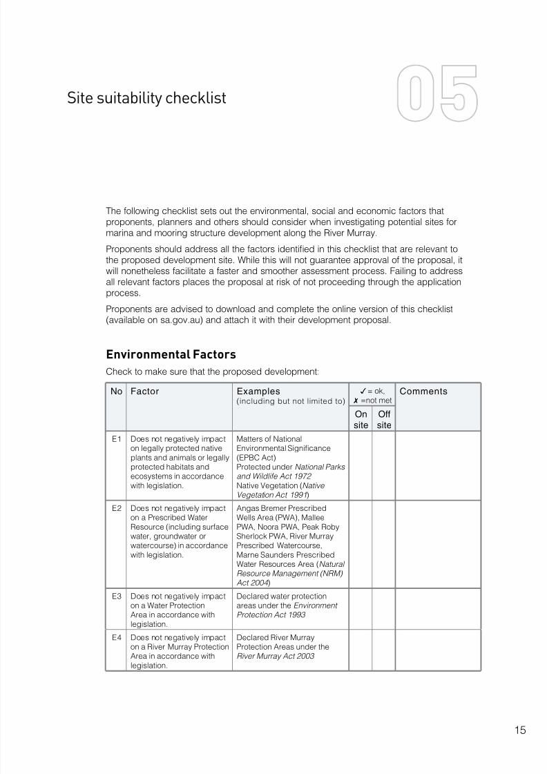
5 Site suitability checklist 15
6 Key issues to be addressed in a development proposal 21
Appendices
1 Definitions
2 The development assessment and decision-making processes in detail
3 Research and analysis
4 Reference maps

8/20/2019 Guide Marina and Mooring
http://slidepdf.com/reader/full/guide-marina-and-mooring 6/60
2

8/20/2019 Guide Marina and Mooring
http://slidepdf.com/reader/full/guide-marina-and-mooring 7/60
3
Introduction and background
About this guide
This guide is intended to assist developers and other proponents who are preparingdevelopment applications for marina and mooring structure development, as well ascouncils, communities and governments that are considering and assessing suchapplications.
The South Australian Department of Planning and Local Government (DPLG) is responsiblefor planning and development decisions along the River Murray and for overseeing theassessment and approval processes related to marina and mooring structure development.These processes have been established to ensure that marina and mooring structuredevelopment is suitably located and follows leading practice in design, construction,maintenance and operation.
Marinas are defined as facilities for the accommodation of large river craft, such ashouseboats. They may also include commercial facilities and residential activities.Mooring structures are defined as structures built to secure large river craft. They may besited in marinas, along riverbanks or on the riverbed. (See Appendix 1 for more detaileddefinitions.)
DPLG strongly recommends that proponents consult this guide, in conjunction with theEnvironment Protection Authority’s Code of Practice for Vessel and Facility Management:Marina and Inland Waters (2008) , before lodging a development application.
For further information, contact DPLG on 08 8303 0600.
General background
South Australia’s River Murray supports a diverse range of commercial, industrial andagricultural activities and is an iconic location for tourism, recreation and conservation.
During the past 10 to 15 years the water quality and environmental health of the River have
seriously declined. The main contributors to this decline are a lack of adequate water flows,increases in salinity and pollutant loads (especially nutrients), bank erosion and a loss ofnative vegetation and habitat.
The South Australian Government has embarked on a series of initiatives to improve thewater quality and ecological health of the River system. This guide is one such initiative. Itaims to encourage the optimal siting and sustainable development of marina and mooringstructures, reduce the potentially adverse effects associated with the accommodation ofhouseboats and other large craft on the river environment, and provide greater certaintyfor developers, councils and the community regarding where and how marina and mooringstructures should be built.

8/20/2019 Guide Marina and Mooring
http://slidepdf.com/reader/full/guide-marina-and-mooring 8/60
4
Policy background
In the late 1980s the South Australian Government undertook a review of the Murray Valleyand the adverse impacts on the health of the River in terms of:
• water quality and water allocation
• recreation and tourism
• boating activities, including houseboating
• agriculture and irrigation
• mining
• land and wetland management
• nature conservation and heritage.
The review found that, while a range of boating opportunities should be provided onthe River, the effects of such activities on water quality, the river environment and otherusers should be minimised. The review therefore made a number of recommendations
regarding the establishment and management of mooring structures and marinas. Therecommendations were to:
• define locational criteria for mooring structures and marinas with a view to allowingdevelopment of such facilities in specified locations
• define appropriate design standards for mooring structures and marinas
• require marinas to provide adequate effluent disposal facilities
• prohibit long-term occupation of houseboats in fixed locations outside marinas.
The use of houseboats and the demand for marina and residential developments on theRiver have steadily increased during the past two decades, giving rise to the preparationof a draft Houseboat, Mooring and Marina Strategy for the River Murray by the South
Australian Government Interagency River Murray Working Group in 2008.The draft strategy underwent widespread consultation among councils, state governmentagencies, industry and stakeholder groups, non-government organisations and members ofthe public during 2008–09.
The consultation process resulted in the preparation of this guide to marina and mooringstructure development.

8/20/2019 Guide Marina and Mooring
http://slidepdf.com/reader/full/guide-marina-and-mooring 9/60
5
Under South Australia’s Development Act 1993 (the Act), all activity defined as‘development’ must be approved by a ‘relevant authority’ before the activity can beundertaken. Heavy penalties may apply to anyone undertaking development withoutapproval.
The construction of marinas and mooring structures for river craft, including houseboats, is
considered development under the Act and therefore any proposals for such developmentmust undergo assessment and obtain development approval. While this processvaries according to the type of development proposed, in general the proponent of thedevelopment must:
• lodge a development application form and pay associated fees
• provide a detailed description of the proposed development
• provide technical plans and specifications of a suitable quality.
Proponents must lodge their applications with the council in whose area the proposeddevelopment is to be situated. The application is then is assessed by the relevant authority,as follows:
• for a single mooring structure or group of less than five mooring structures, the authorityis the local council, which delegates assessment to qualified staff or to its DevelopmentAssessment Panel
• for marina developments and groups of five or more mooring structures, the authority is theindependent state authority known as the Development Assessment Commission (DAC).
Development applications may require a number of ‘consents’, such as developmentplan consent, which involves assessment against the provisions of the local developmentplan, and building rules consent, which involves assessment against the Building Codeof Australia and other relevant Australian standards. If land is to be subdivided under theproposal, land division consent is also required.
Large marina development and development with residential and/or commercial
components may be declared ‘Major Development’ by the Minister responsible for the Act.
Summary of the development
assessment process
8/20/2019 Guide Marina and Mooring
http://slidepdf.com/reader/full/guide-marina-and-mooring 10/60
6
Major Development applications must be lodged with the DAC, pursuant to section 46 ofthe Act. The DAC thoroughly assesses the environmental, social and economic effects ofthe development and provides opportunities for public comment. It also determines thelevel of assessment required for Major Development proposals, as follows:
• an Environmental Impact Statement (EIS) may be required for complex proposals that are
likely to have effects beyond the boundaries of the site
• a Public Environmental Report (PER), also known as a Targeted EIS, may be required forless complex proposals involving a narrower range of issues
• a Development Report (DR) may be required for proposals that are not expected to raisecomplex issues.
(See Chapter 6 for detailed descriptions of assessment levels.)
Final decisions on Major Development proposals are made by the Governor of SouthAustralia on the advice of Cabinet.
Some applications for development plan consent may be referred to state governmentagencies and statutory authorities for advice or direction; for example:
• the Environment Protection Authority (EPA)
• the Minister for the River Murray (under the River Murray Act ) or the Department for Water(DFW) acting on behalf of the Minister
• the Department of Environment and Natural Resources (DENR)
• agencies responsible for Native Title, Aboriginal heritage and Non-Aboriginal heritage
• the Department for Transport, Energy and Infrastructure (DTEI).
In some situations—depending on the categorisation of the proposed development—thelocal community or adjoining landowners may be invited to comment on an application.
As a result of the assessment process, the relevant authority may:
• grant consent to an application without change, or
• grant consent to an application subject to conditions, or
• refuse the application.
(See Appendix 2 for further details about the development assessment and approval process.)

8/20/2019 Guide Marina and Mooring
http://slidepdf.com/reader/full/guide-marina-and-mooring 11/60
7
Principles for leading practice marina and
mooring structure development
This chapter outlines the leading practice principles that have been established to guidethe development of marinas and mooring structures in order to ensure the ongoing health ofthe River Murray and environs.
Development proponents should consider these principles in conjunction with the sitesuitability checklist in Chapter E in order to identify sites that are best suited to marina and
mooring structure development and that are unlikely to generate adverse environmental,economic and social effects.
Marina development
Leading practice marina development should be sited in locations:
• close to existing townships or settlements with adequate infrastructure connections
• away from sensitive floodplains or wetlands
• away from Aboriginal heritage sites and objects
• away from habitat that supports threatened native flora or fauna species
• away from high salinity impact/discharge zones
• at least 3 kilometres upstream and 0.5 kilometres downstream of a water supply intake
• where the effect of the marina on the ecological health of the river will be neutral orbeneficial
• where surrounding landscape scenic values are not adversely affected.
Leading practice marina development should be designed to:
• ensure that water quality along the River is maintained or improved
• ensure that the quality of discharges to the River is equal to or better than the quality ofRiver water that enters the marina
• minimise the evaporative loss of River water
• accommodate changes in weir pool levels of up to or minus 1 metre for environmentalflow manipulation purposes
• maintain or improve habitat for native fauna
• complement and enhance the amenity of the area.

8/20/2019 Guide Marina and Mooring
http://slidepdf.com/reader/full/guide-marina-and-mooring 12/60
8
Leading practice marina development should be constructed in a manner that:
• minimises turbidity
• does not use contaminated fill material
• does not spread pest plants and animals
• minimises environmental harm, following the duty of care and objectives set out in theRiver Murray Act 2003
• adheres to the requirements of the Environment Protection Act 1993
• provides adequate operational facilities, such as waste disposal, boat launch and washdown facilities, and public toilets.
Mooring structure development
Leading practice mooring structure development should be located:
• outside navigation channels so they do not pose a safety or navigation hazard
• so as to allow safe access from the navigable channel
• away from environmentally sensitive areas
• away from erosion prone areas
• more than 50 metres away from a wetland
• away from formally designated water recreation areas (for example, for swimming, skiing, etc)
• more than 100 metres away from either side of a ferry crossing
• more than 150 metres away from either side of a lock
• a safe distance from submerged pipes and powerlines
• more than 3 kilometres upstream and 0.5 kilometres downstream of town water supplyintakes
• away from areas in which damage, disturbance to, or interference with any heritage siteor object might be caused
• a minimum of 6 metres from other structures used for boat mooring
• a minimum of 3 metres from all adjacent property boundaries 1.
1 Property boundaries are not an extension of land boundaries, but extend perpendicular to the bank from where the land boundary meets the water.This is especially important for allotments with a narrow front at the water and a wide rear.

8/20/2019 Guide Marina and Mooring
http://slidepdf.com/reader/full/guide-marina-and-mooring 13/60
9
Leading practice mooring structure development should be designed to:
• stabilise the riverbank and minimise disturbance of the riverbank or riverbed
• ensure that appropriate erosion control devices are in place
• facilitate removal of pest plants (for example, willows)
• ensure revegetation with native species to compensate for any disturbance of theriverbank
• not be used for permanent occupation (on-board living), unless the structure is part of adedicated, approved marina facility that meets current government standards
• allow for the safe mooring of vessels under expected riverine conditions (includingincreased water flows and floods, as far as practicable)
• have the structure’s terminal end located in water that is deep enough to prevent the lowestpoint of the boat from touching the benthos and prevent damage from propeller wash
• not extend further than the line of existing structures
• not adversely affect scenic quality or amenity value, either through the structure itself orits use by a houseboat.
Leading practice mooring structure development should be constructed so that structures:
• do not exceed 10 per cent of the River width
• can be certified by an appropriately qualified professional to safely resist the combinedeffects of expected loads, including:
– the weight of the mooring structure itself
– operational loads, such as pedestrians on the decking, vessel collision and mooringloads
– environmental loads, such as currents, wind, wave actions and debris, up to the 1956
flood level – tidal loads, storm surges and sea-level rise from global warming in coastal areas
• allow for easy maintenance that will not cause harm to the River
• contribute positively to habitat provision
• have dimensions limited to those enabling the structure to perform its primary function

8/20/2019 Guide Marina and Mooring
http://slidepdf.com/reader/full/guide-marina-and-mooring 14/60
10
• are raised a sufficient distance to:
– obviate the need for steps and other alterations to the riverbank
– allow sunlight to reach the benthos (by using mesh over the first two metres)
– ensure that no part of the deck is less than 1 metre from the riverbed.

8/20/2019 Guide Marina and Mooring
http://slidepdf.com/reader/full/guide-marina-and-mooring 15/60
11
Guidelines for the preparation of a marina
or mooring structure development proposal
Proposal structure and contents
DPLG recommends that marina and mooring structure development proposals orapplications include the following sections:
1 Executive summaryThis should provide a concise overview of the proposal and the details covered underthe headings discussed below. While not required for smaller development proposals, anexecutive summary is highly recommended for those proposals requiring an EIS or PER aspart of the Major Development (section 46) assessment process.
2 Introduction
This should briefly cover:
• the background to, and objectives of, the proposed development
• details about the proponent
•
relevant legislative requirements and approval processes.
3 Need for the proposed development
This should describe the rationale for the proposed development, including:
• the specific objectives that the proposed development is intended to meet, includingmarket objectives
• the expected benefits and costs of the proposed development, including those thatcannot be adequately described in monetary or physical terms (for example, effects onscenic values)
• the environmental, economic and social arguments supporting the proposal.

8/20/2019 Guide Marina and Mooring
http://slidepdf.com/reader/full/guide-marina-and-mooring 16/60
12
4 Description of the proposed development
This should describe in detail:
• the proposed development
• the existing environment and the locality in which it is to be sited
• the location, layout, elevation and appearance of structures (and buildings, whererelevant), an indicative land division plan (if relevant), a description of easements andinfrastructure requirements and availability
• the staging (if relevant) and timing of the proposal, including expected dates forconstruction and operation
• the management arrangements for the construction and operational stages.
5 Assessment of expected environmental, social and economic impacts
For medium- to large-scale development proposals, proponents should identify anddescribe all likely environmental, social and economic effects of the proposed development.
(Refer to the comprehensive list of potential effects of marinas and mooring structures inChapter F.)
6 Consistency with development plan policy
This should include an assessment of the proposal against the relevant provisions (council-wide and zone provisions) of the local development plan.
Proposals assessed as part of the Major Development process may also require adiscussion of the proposal’s consistency with legislation beyond the Development Act 1993 .
7 Avoidance, mitigation, management and control of adverse effects
This should describe how the proponent will avoid, mitigate, satisfactorily manage and/or
control any potentially adverse effects of the proposed development on the physical, socialand economic environment.
8 Appendices
Any technical and additional information relevant to the proposal (for example, maps,plans, elevations, graphs, tables, photographs, reports, and certificates of title) should beincluded as appendices, as well as a glossary (if appropriate).
8/20/2019 Guide Marina and Mooring
http://slidepdf.com/reader/full/guide-marina-and-mooring 17/60
13
Site plans
Site plans in development proposals should illustrate the following:
• all features to scale, including a bar-scale and a North Arrow
• an elevation view and a section view
• the location of existing and proposed features, including:
– any dwellings and outbuildings on the property
– the proposed structure(s), including dimensions and materials to be used
– the depth of water at the point where any part of the structure(s) will touch the riverbed
– the depth to which piles will be driven into the riverbed
– any navigable sections of the river
– existing vegetation (including trees, shrubs, groundcovers and reeds)
– any submerged or partially submerged wood
– the property boundaries of the allotment and adjoining allotments
– any registered or recorded Aboriginal site, object or remains (as advised byrepresentatives of local Aboriginal people and/or the Minister for Aboriginal Affairs andReconciliation)
– any Heritage Places, Historic Shipwrecks or other culturally significant features on theland or in the water in proximity to the site.

8/20/2019 Guide Marina and Mooring
http://slidepdf.com/reader/full/guide-marina-and-mooring 18/60
14
8/20/2019 Guide Marina and Mooring
http://slidepdf.com/reader/full/guide-marina-and-mooring 19/60

8/20/2019 Guide Marina and Mooring
http://slidepdf.com/reader/full/guide-marina-and-mooring 20/60
16
No Factor Examples(including but not limited to)
3= ok,7=not met
Comments
Onsite
Offsite
E5 Does not negatively
impact on water quality inaccordance with legislation.
Compliance with the
Environment Protection (WaterQuality) Policy 2003 underEnvironment Protection Act
1993
E6 Does not pollute theenvironment in accordance
with legislation.
Compliance with EnvironmentProtection Act 1993
E7 Does not introduce, orfacilitate an increase in,
listed pest plants andanimals or noxious speciesand exotic organisms inaccordance with legislation.
Natural Resource Management(NRM) Act 2004
Fisheries Management Act2007
E8 Does not negatively impacton salinity levels within theRiver Murray catchment in
accordance with legislationand Murray-Darling BasinGovernmental Agreements.
Basin Salinity ManagementStrategy 2001-2015
River Murray Act 2003
E9 Is located in an area of
suitable geology, soilsand topography, avoidingunstable areas, acid
sulfate soils and locationsvulnerable to rapid changeor erosion.
E10 Will be able to deal
adequately with any wastemanagement requirementsin accordance with
legislation.
Compliance with Environment
Protection Act 1993 and/ or Public and EnvironmentalHealth Act 1987
E11 Will meet site contaminationrequirements in accordance
with legislation.
Compliance with EnvironmentProtection Act 1993

8/20/2019 Guide Marina and Mooring
http://slidepdf.com/reader/full/guide-marina-and-mooring 21/60
17
No Factor Examples(including but not limited to)
3= ok,7=not met
Comments
Onsite
Offsite
E12 Will not alter water flows
or sediment movementsresulting in environmentalharm or the creation of
hazards to other river users.
Sediment accumulation and
movement, water flow patterns
E13 Does not negatively impacton significant wetlands.
Significant wetlands alongthe river that are not legally
protected through listing
E14 Site has capacity for aconstructed wetland.
E15 Is located on anappropriately sized area offloodplain to provide for off-floodplain housing.

8/20/2019 Guide Marina and Mooring
http://slidepdf.com/reader/full/guide-marina-and-mooring 22/60
18
Social Factors
Check to make sure that the proposed development:
No Factor Examples(including but not limited to)
3= ok,7=not met
Comments
Onsite
Offsite
S1 Does not negatively impacton landscape amenity inaccordance with planning
policy.
State government planningpolicy, local councildevelopment plans and River
Murray Act 2003
S2 Does not negatively impacton cultural heritage in
accordance with legislation.
State Heritage register underthe Heritage Places Act 1993
Shipwrecks under the HistoricShipwrecks Act 1981
S3 Does not negatively impacton Aboriginal heritage inaccordance with legislation.
Claims, titles, rights and sitesunder the Native Title Act1993 (Commonwealth) andAboriginal Heritage Act 1988
(SA)
S4 Does not negatively impacton sites of geological
significance in accordancewith legislation.
Sites of geological significanceon the State Heritage register
(Heritage Places Act 1993 )
S5 Does not have an overall
negative impact on riveraccess and access rights.
Local council development
plans
Licences and approvals under
the Crown Lands Act 1929
S6 Does not negatively impacton river safety.
Licences and approvals underthe Harbours and NavigationAct
Ferry crossings, locks and riverbends
S7 Is not located within 3km upstream and 500 mdownstream of a SA Water
off-take point.
SA Water off-take points forpotable water supply

8/20/2019 Guide Marina and Mooring
http://slidepdf.com/reader/full/guide-marina-and-mooring 23/60
19
No Factor Examples(including but not limited to)
3= ok,7=not met
Comments
Onsite
Offsite
S8 Does not negatively impact
on local cultural heritage notprotected by law.
Sites of local cultural
significance
S9 Will have appropriate socialservices for increasedpopulation.
Hospital, suitable township, etc

8/20/2019 Guide Marina and Mooring
http://slidepdf.com/reader/full/guide-marina-and-mooring 24/60
20
Economic Factors
Check to make sure that the proposed development:
No Factor Examples(including but not limited to)
3= ok,7=not met
Comments
Onsite
Offsite
1 Does not negatively impacton primary productionactivities.
Risk of damage to irrigationinfrastructure including in-takepoints, pumps, channels,
pipes, etc
Water quality reduction around
water in-take points
2 Does not negativelyimpact on commercial or
recreational fishing activity.
Recreational fishing spots thatalso generate local tourism and
other commercial activity
Commercial fisheries or other
aquaculture industries
Fisheries habitat that
contributes to natural fishproduction
3 Has access to requiredinfrastructure.
Power, sewerage, transport,roads, etc
4 Complies with land tenurerequirements.
Crown lands, councildevelopment plans
5 Is located a suitable
distance from an existingoff-river marina.
Close proximity of off-river
marinas increases the risk offinancial failure as a result ofover supply and low demand.

8/20/2019 Guide Marina and Mooring
http://slidepdf.com/reader/full/guide-marina-and-mooring 25/60
21
Key issues to be addressed in a
development proposal
This chapter identifies in detail the various issues that may affect marina and mooringstructure development proposals. Proponents should consider all these issues and addressthose that are relevant, depending on the type and scale of the proposed development.
Proposals requiring an EIS, PER or DR as part of the Major Development assessmentprocess should address all the issues identified by the DAC when completing their
application.
1 Environmental issues
Climate change and sustainability
• Potential effects of climate change: the likely implications, including implications of sealevel rise, and the need to adopt adaptive management strategies.
• Resource use: minimise or reduce the use of resources during construction andoperational phases.
• Greenhouse gas emissions: minimise, reduce and ameliorate emissions through the useof alternative or renewable energy sources and off-sets.
• Reduced water availability: reduce reliance on the River through greater use of recycledwater (particularly stormwater and waste water) and reuse of grey water.
• Waste management: incorporate recycling and resource recovery strategies for anyresidential uses or tourist facilities.

8/20/2019 Guide Marina and Mooring
http://slidepdf.com/reader/full/guide-marina-and-mooring 26/60
22
River Murray
• Upstream and downstream users of the River: minimise the effects of proposeddevelopment on potable water supplies and downstream water supply intakes.
• Visual amenity: minimise the visual effects of the proposed development, especially theappearance and built form of buildings and structures (including earthworks, roads andinfrastructure) from the River and environs.
• Native flora and fauna: minimise the effect of proposed development on riverine nativeflora and fauna, especially as a result of discharges from the marina waterways and byincreased human activity.
• Biodiversity: minimise the effect of proposed development on the biological diversityand conservation significance of any wetland or riverine system, including design andmanagement measures to mitigate habitat fragmentation, loss of connectivity, pestspecies and potential changes to hydrology and water quality.
• Recreational and commercial boating: minimise and mitigate the effects of boatmovements and activities, including pollutant loads, the risk of spills and noise.
• Environmental flows: proposed development should not adversely impact on the River’senvironmental flows.
• Riverbank protection: measures to protect the riverbank, existing wetlands andwaterways from erosion, litter and pest plants during and after construction (includingbuffers) should be incorporated into proposed development.
• Public access – management of public access to the riverfront, including any mooring ofhouseboats during both construction and operational phases, is required.
• Historic shipwrecks: measures to protect any historic shipwrecks within the area, inaccordance with the Historic Shipwrecks Act 1981, are required.

8/20/2019 Guide Marina and Mooring
http://slidepdf.com/reader/full/guide-marina-and-mooring 27/60
23
Water quality
• Water discharge: the proposed development should not have any adverse impact onwater quality and the health of the River.
• Water quality: measures to protect and maintain suitable water quality in waterways andexisting and constructed wetlands should be incorporated into proposed development,particularly the management of run-off and the control of pollutant and micro-organismsources.
• Water allocation: arrangements for securing a water allocation for the filling andmaintenance of water levels in the proposed marina basin, waterways and constructedwetland, should be included.
• Pollution: measures to prevent pollutants, fertilisers, herbicides and pesticides fromentering the marina and waterways should be incorporated.
Native vegetation (terrestrial and aquatic)
• Native vegetation clearance: the extent and significance of native vegetation (individual
species and communities) that may need to be cleared or disturbed during constructionshould be minimised, with remnant stands incorporated into the design to compensatefor the loss of native vegetation and habitat and to deliver significant environmentalbenefit. Any communities or individual species listed under the CommonwealthEnvironment Protection and Biodiversity Conservation Act 1999 should be protected.
• Biodiversity: changes in biological diversity at the interface between the proposeddevelopment and existing vegetation (the ‘edge effect’) should be appropriatelymanaged.

8/20/2019 Guide Marina and Mooring
http://slidepdf.com/reader/full/guide-marina-and-mooring 28/60
24
Native fauna (terrestrial and aquatic)
• Fauna and/or habitat loss or disturbance: the extent and significance of fauna and habitatloss and disturbance should be minimised and the ability of communities or individualspecies to recover (especially the occurrence of threatened or significant species)should be described.
• Conservation status: the status of faunal communities or individual species, including anylisted under the Commonwealth Environment Protection and Biodiversity ConservationAct 1999 , should be described.
Groundwater and land contamination
• Existing groundwater and land related environmental conditions: these conditionsshould be described (and supported by site specific investigations), including possiblecontamination sources.
• Acid sulfate soils: management measures to address acid sulfate soils should bedescribed during construction and operation.
•Land contamination measures: procedures to identify whether the land is contaminatedand management measures that would be required during construction and operationshould be incorporated.
• Fill: short- and long-term effects of fill placement and the construction of channels andbasins on land and/or groundwater quality and movement should be described.
Management
• Environmental risk: any risk of causing or exacerbating environmental problems inthe locality should be described, along with mitigation measures and their expectedeffectiveness.
• Water quality and ecosystems: design and management requirements to maintain
suitable water quality and healthy ecosystems, particularly the establishment of a suitablehydrological regime that takes into consideration the implications of environmental flowregimes.
• Waste management: arrangements for managing solid waste, black water and grey waterand strategies for households and tourist facilities to incorporate recycling and resourcerecovery should be described.
• Pests: management of pest plants and animals within and around the proposeddevelopment should be described.
• Maintenance dredging or removal of aquatic plant growth: including disposal options andeffects on the environment and community.

8/20/2019 Guide Marina and Mooring
http://slidepdf.com/reader/full/guide-marina-and-mooring 29/60
25
Monitoring
• Measures: steps to monitor, manage and rehabilitate effects on the River andgroundwater supplies should be described.
• Dust: the control and monitoring of all potential sources of air pollution (especially dust),including measures for the reduction or elimination of dust, should be described.
General
• Noise: identify all potential noise sources associated with the operation of the proposeddevelopment, and describe the extent to which these noise emissions could be reducedand contained to minimise the associated effects upon the environment, the marinacommunity and the wider locality.
• Nuisance insects: measures to control nuisance insects, particularly mosquitopopulations and other potential disease vectors that could pose a risk to human healthshould be discussed.
8/20/2019 Guide Marina and Mooring
http://slidepdf.com/reader/full/guide-marina-and-mooring 30/60
26
2 Risk/hazard management
• Public safety: measures to ensure public safety during construction and operation,including permitted recreational use of water bodies, should be incorporated.
• Pollution: procedures and strategies to prevent, manage and mitigate pollution spills,
sewage leaks, discharges from houseboats and algal blooms should be described.• Hazardous materials: measures to manage and contain hazardous, flammable or
explosive materials in the commercial areas or on boats should be outlined.
• Flood protection: flood mitigation strategies and compliance with relevant flood protectionpolicies in the development plan should be described.
• Riverbank protection: design measures to protect the bank from wave action should beincorporated.
3. Effects on communities
• Township character: the effects of the proposal on the existing character of a townshipand surrounds should be described.
• Township integration: how the proposal would be integrated with the existing township(including linking proposed and existing walking and cycling trails) should be described.
• Traffic: measures to manage and mitigate traffic generation and truck movements to andfrom the site during construction and the impact on local roads should be described.
• Tourism and recreation: effects on existing tourism and recreation activities (includinginfrastructure) should be described.
• Adjoining land uses: the potential impact from adjoining land uses on the proposeddevelopment should be described.
• Land tenure: land tenure arrangements (both during and after construction) for theproposed development and the opportunities for commercial, private recreational orpublic access to berths, launching facilities or other associated facilities should bedescribed.
• Public facilities: the location and availability of public facilities including telephones,toilets, open space, recreation areas and the lighting of public areas should be outlined.
8/20/2019 Guide Marina and Mooring
http://slidepdf.com/reader/full/guide-marina-and-mooring 31/60
27
4. Economic issues
• Employment and investment: the effects of the proposed development on localemployment and investment, including the ‘multiplier effect’, should be described.
• Business: the potential for the proposal to attract and enhance the business operations of
other allied industries, tourism and commercial ventures should be outlined.• Infrastructure: potential costs or savings to the government of infrastructure expansion
and maintenance with regard to transport networks, electricity supply, water supply,sewerage or management of the River should be identified and described.
5. Native Title and Aboriginal heritage
• Cultural significance: the significance of the proposed location to Aboriginal people,including anthropological, archaeological, historical or traditional significance, should bedescribed.
• Sites or objects: the potential impact that the proposal may have on any Aboriginal
sites or objects listed in the SA Register of Aboriginal Sites and Objects or that maybe determined by the Minister pursuant to the Aboriginal Heritage Act 1988 afterconsultation with Aboriginal councils or groups should be described.
• Aboriginal Heritage Act 1988 : measures to ensure compliance with the Act should bedetailed.
• Native Title: any native title issues in respect of the requirements of the Native Title Act1993 (Commonwealth) and the Native Title Act 1994 (South Australia) should be detailed.
6. Non-Aboriginal heritage
• Sites: the potential impact that the proposal may have on any sites listed on the National
Heritage List (under the Environment Protection and Biodiversity Conservation Act 1999 )or on the South Australian Heritage Register should be described.
• Heritage places and historic shipwrecks: measures to ensure compliance with theHeritage Places Act 1993 and the Historic Shipwrecks Act 1981 should be outlined.

8/20/2019 Guide Marina and Mooring
http://slidepdf.com/reader/full/guide-marina-and-mooring 32/60
28
7. Construction and operational effects
• Site construction plan: a site construction plan and strategies to minimise effects on thelocal environment should be provided.
• Earthworks: the proposed approach for dredging/floodplain excavation and earthworks
drainage, frequency, disposal of excavated material, maintenance activities and effectson water quality and the environment, particularly turbidity, should be detailed.
• Construction materials: the source and origin of any construction materials, includingrevetments and fill for land forming, and the effects of the storage of constructionmaterials on local amenity should be described.
• Fill: the implications of placing any large amount of fill on the floodplain, particularlycontamination and implications for natural drainage, water circulation and floodmanagement should be detailed.
• Turbidity: measures to minimise turbidity, particularly from boating movements and waveaction, should be described.
• Management agreements: management agreements for the construction and operation
of the proposed development should be described.
• By-laws and encumbrances: any proposed by-laws and encumbrances to controland manage activities, particularly to ensure that the development is environmentallysustainable in the long-term, should be described.
8. Effects on infrastructure requirements
• Impacts: the impact of the proposed development on gas, electricity, water, sewerage,stormwater management, communication systems and local roads should be described.
• Water sensitive urban design (WSUD): WSUD measures and the implications of adoptingthem for minimising water use and managing stormwater and wastewater should bediscussed.
• Waste disposal: facilities to be provided for waste disposal from recreational, commercialand permanently occupied vessels, including black water, grey water and solid wasteshould be described.
• Emergency services: emergency services arrangements should be detailed.
8/20/2019 Guide Marina and Mooring
http://slidepdf.com/reader/full/guide-marina-and-mooring 33/60
29
9. Planning and environmental legislation and policies
• Development plan: the proposal’s variance from and consistency with the relevantprovisions of the development plan should be described.
• Environment Protection Act 1993 : the proposal’s variance from and compliance with the
provisions of the Act, including strategies regarding any non-compliance issues that mayarise (for example, separation distances) should be described.
• River Murray Act 2003 : the proposal’s variance from and consistency with therequirements of the Act and the Murray-Darling Basin Agreement should be described.
• Legislative requirements: the requirements and the range of approvals needed tocomplete the proposed development should be detailed.

8/20/2019 Guide Marina and Mooring
http://slidepdf.com/reader/full/guide-marina-and-mooring 34/60
30

8/20/2019 Guide Marina and Mooring
http://slidepdf.com/reader/full/guide-marina-and-mooring 35/60
31
Definitions
Marina
A marina is a facility used primarily for the sheltered and secure accommodation of rivercraft, particularly houseboats and larger vessels2, and may comprise a range of facilities,such as:
• mooring structures, berths, pontoons, piers or other securing facilities
• boat launching ramp
• dry dock or slipping areas
• slipways or hoists
• wharves or jetties
• chandlery
• boat construction, maintenance, repair or sale facilities
• kiosk, fuel supplies, power, water, effluent pump, toilets, showers
• land based areas for hardstand boat storage and car parking
• tourist or recreation areas
• commercial facilities (for example, tavern or store)
• tourist accommodation
• residential allotments, especially waterfront and /or dry land allotments
• waterfront housing estates with provision for private mooring structures.
Off-river marinas
Marinas developed in a wetland on a backwater/anabranch or in a basin excavated on thefloodplain. Formal off-river marinas are usually fully constructed developments with abuttingboardwalks, jetties, bank treatments, mooring structures and associated boating and visitor
facilities (for example, River Glen Marina near Murray Bridge, Kia Marina near Mannum andthe Hindmarsh Island Marina).
On-river marinas
Rows of houseboats moored to the riverbank. These can range from large-scale (forexample, at Morgan, Berri and Waikerie) to small-scale, informal marinas (for example, atKingston-on-Murray and Paringa).
2 Marinas on the River Murray are intended mainly for houseboats, but may also be used by other large vessels that have similar impacts (ie, provide forovernight stays and have the same potential pollutant sources).
Appendix

8/20/2019 Guide Marina and Mooring
http://slidepdf.com/reader/full/guide-marina-and-mooring 36/60
32
Canal estate development
Development that:
• incorporates wholly or in part a constructed canal, or other waterway or water body, thatis inundated by or drains to a natural waterway or natural water body by surface water orgroundwater, and
• where the titles to the subdivided lots extend into, abut or are proximate to theconstructed waterway, and
• includes the construction of dwellings (which may include tourist accommodation) whichmay or may not require the use of a sufficient depth of fill material to raise the level ofall or part of that land on which the dwellings are to be located in order to comply withrequirements relating to residential development on flood prone land, and
• may include provision for individual private mooring structures associated with waterfrontallotments.
Waterfront canal estates increasingly provide private mooring structures; these can beconsidered ‘de facto’ marinas as they usually provide moorings and potentially have the
same impact on the river as a traditional marina.
Mooring structure
A built structure used for securing a vessel; may be located in a marina development, alongthe riverbank or in the riverbed. They are preferable to trees and infrastructure for drinkingwater, piping, etc, which are not appropriate for mooring.
Mooring site
A formally recognised and approved location where the activity of mooring can occur usingan approved mooring structure.
Swing mooring
A permanent mooring structure that sits on the riverbed with a floating buoy attached.These types of moorings are prevalent in the Lower Lakes (Albert and Alexandrina) but arenot common on the main river channel.
River craft
Any vessel with overnight accommodation.

8/20/2019 Guide Marina and Mooring
http://slidepdf.com/reader/full/guide-marina-and-mooring 37/60
33
River Murray
As declared under the River Murray Act 2003 , the River Murray includes the main stem andfloodplain, and all anabranches, backwaters, wetlands, estuaries, coastal areas (includingthe Coorong and Lower Lakes) and tributaries (including the tributaries of the EasternMount Lofty Ranges). The River also includes the natural resources associated with the
River (and floodplain etc), including not only water, soil, minerals, vegetation, air, animalsand ecosystems, but also cultural heritage, natural heritage, amenity and geological values.
River Murray Valley
Includes all land adjacent the River Murray, comprising four main physical features: thewaterfront, floodplain, valley face and fringe zone.
Waterfront
Land immediately adjoining the mainstream or backwaters, and within 100 metres of normalpool level.
Floodplain
Land in the Murray Valley subject to flooding, however rarely flooding occurs.
Flood zone (as defined by the development plan under the Development Act)
Land which was inundated by flood waters during the 1956 flood.
Valley face
The slopes and cliffs visible from the River Valley.
Fringe zone (as defined by the Development Act)
An area immediately adjacent to the Flood Zone and Valley face.
Large vessel
A vessel that is generally in excess of 7.5 metres in length with facilities for overnight
accommodation.Water off-take
Infrastructure (for example, channel, pipework) required for drawing water for the purposesof filtered and unfiltered water supply.

8/20/2019 Guide Marina and Mooring
http://slidepdf.com/reader/full/guide-marina-and-mooring 38/60
34
Black Water
Wastewater from toilets or urinals, defined as either treated or raw (untreated). It containsdiseases causing bacteria and viruses that can result in human illness from direct contact,or by consumption of affected fish and shellfish. It also contributes to nutrient build-up inecosystems that result in changes to habitat and the proliferation of nuisance pest species.
Grey Water
Water that has been used for washing, laundering, bathing or showering. It may containdissolved or undissolved by-products such as fat and oil, food scraps that containnutrients, household chemicals, soap and detergent rich in phosphate and nitrate, andmicrobiological pathogens. If discharged into aquatic environments it can damageecosystems, lead to nutrient enrichment (algal blooms) and pose significant human healthrisks.

8/20/2019 Guide Marina and Mooring
http://slidepdf.com/reader/full/guide-marina-and-mooring 39/60
35
The development assessment and
decision-making processes in detail
Overview
In South Australia, specific types of activity are defined as ‘development’ and needapproval before they can be undertaken.
The Development Act 1993 (the Act) defines ‘development’ to include:
• a change in the use of land or buildings
• the creation of new allotments through land division (including Strata and Community Titledivision)
• building work (including construction, demolition, alteration and associated excavation/fill)
• cutting, damaging or felling of significant trees (in designated locations)
• specific work in relation to State and Local Heritage Places
• prescribed mining operations
• other acts or activities in relation to land as declared by the Development Regulations.
No development should be undertaken in South Australia without an appropriate
development approval being obtained from a ‘relevant authority’ after an application andassessment process. Heavy penalties may apply to persons undertaking developmentwithout approval.
This section outlines the general development application and assessment system, aswell the system as it relates to marina and mooring structure development along the RiverMurray. Possible assessment paths are shown in Figure 1.
Appendix

8/20/2019 Guide Marina and Mooring
http://slidepdf.com/reader/full/guide-marina-and-mooring 40/60
36
Figure 1 Major Developments or Projects – assessment processes and decision-making
Minister makes declaration thedevelopment/project is of major environmental,
social or economic importance.
Proponent lodges development application orproject proposal, (with relevant fees) to give
enough information for DevelopmentAssessment Commission to identify issues.
Department of Planning and Local Governmentprepares a preliminary description ofsignificant issues; and may invite written
submissions from agencies.
Commission consults criteria in Regulations,
relevant authorities; reports to Minister ondecisions regarding level of assessment and
content of Guidelines.
Proponent prepares EIS, PER or DR.
EIS, PER or DR released for comment andpublic meeting held.
Proponent responds (where required) tosubmissions and matters raised by public andrelevant bodies.
Minister prepares Assessment Report; copies
of all reports available to council/s and public.
Application (usually revised) forwarded fordecision-making by Governor, or material
forwarded to relevant Minister if a project.
Department of Planning and Local Government
SA invites written submissions from agencies onGuidelines
Minister’s declaration in South AustralianGovernment Gazette
Proponent’s application/proposal
EIS, PER or DR exhibited and public meetingheld if required
Commission decides level of assessment, mainissues to be addressed in Guidelines and
reports to Minister
EIS, PER or DR prepared using Guidelines
Decision making
Written response from proponent
Assessment Report prepared by the Ministerand made publicly available

8/20/2019 Guide Marina and Mooring
http://slidepdf.com/reader/full/guide-marina-and-mooring 41/60
37
General
Lodging a development application
The process for obtaining development approval varies according to the type ofdevelopment proposed. The process generally involves the lodgement of:
• an application form and fees, which vary according to the type of development andconsent being sought
• plans and details describing the proposed development
• technical plans of footings and structures and technical specifications (for example, inthe case of building work).
Development applications—with the exception of declared Major Developments and landdivisions—are lodged with the council in whose area the land relevant to the application issituated. Major Developments and land divisions are assessed by the independent stateauthority called the Development Assessment Commission (DAC).
Assessment process (consents and approvals)A development application may require a number of ‘consents’ before it receives finaldevelopment approval. These consents can be granted on the basis of a single applicationin most cases. The consents that make up a final approval are commonly ‘building rulesconsent’ (which involves assessment against the building rules) and ‘development planconsent’ (which involves assessment against the provisions of the local area developmentplan; a development plan contains the objectives, policies, zoning, maps and standards fordevelopment in the area.) If land is being subdivided, a separate ‘land division consent’ isalso required.
Some applications for development plan consent are referred to state agencies andstatutory authorities for advice or direction. Those bodies may include, for example, the
Environment Protection Authority or the Minister for the River Murray. In some situations, thelocal community or adjoining landowners may be invited to comment on an application.
Building rules consent is granted by the council or a private certifier of building work. Thelocal council is responsible for issuing the final development approval after checking that allconsents are consistent. No work can commence until the development approval is issued.

8/20/2019 Guide Marina and Mooring
http://slidepdf.com/reader/full/guide-marina-and-mooring 42/60
38
Relevant authority (development plan consent)
The application is then assessed and decided by the ‘relevant authority’. The local councilis most often the relevant authority; it must delegate assessment to qualified staff or acouncil Development Assessment Panel (DAP) made up of a majority of independentmembers. The assessment process may be undertaken by a group of adjoining councils
known as a Regional Development Assessment Panel (regional panel), if one exists. Insome instances the DAC is the assessment and decision making body.
The DAC is the decision-making authority for about half of all development applicationsin the River Murray, River Murray Flood or Flood zones, including marina and mooringstructure development for five or more boats, nearly all land divisions, and some dwellings.
Complying, non-complying and merit development
Land uses and activities that are listed as ‘complying’ and ‘non-complying’ in thedevelopment plan are subject to specific development assessment rules. If a developmentapplication is listed as complying by either the development plan or Schedule 4 of theDevelopment Regulations, development plan consent must be granted, provided the
application meets all the standards for complying development. If a complying standard isnot met, the application defaults to a ‘merit’ assessment.
Where a land use or activity is defined as ‘non-complying’, it is considered to be incompatiblewith the objectives for that zone and therefore inappropriate, and will generally not be grantedconsent. However, non-complying land uses may be approved if they meet the policies in thedevelopment plan read ‘as a whole’. This can occur only where both the DAC and the DAP (orregional panel) agree, and the application has undergone a rigorous assessment process.
Development that is not listed as either complying or non-complying in the developmentplan and Development Regulations is subject to a merit assessment. Such applications areassessed against all the relevant policies in the development plan.
Decision (development plan consent)After the assessment process, the relevant authority can decide to:
• grant consent to an application without change;
• grant consent to an application subject to conditions; or
• refuse the application.
A development application must be refused if it is ‘seriously at variance’ with the policies inthe relevant development plan.
The council, regional panel or the DAC must advise the applicant and any member of thecommunity who was eligible to comment on the proposal of its decision and of their appealrights (if any) in relation to the decision.

8/20/2019 Guide Marina and Mooring
http://slidepdf.com/reader/full/guide-marina-and-mooring 43/60
39
Major Development assessment
Under section 46 of the Development Act 1993 , the Minister responsible for the Actcan declare a proposed development a ‘Major Development’ if he or she believessuch a declaration is appropriate or necessary for proper assessment of the proposeddevelopment, and where the proposal is considered to be of major economic, social or
environmental importance.
This triggers a thorough state government assessment process with opportunity for publiccomment before any decision is made on whether the proposal warrants an approval (thefinal decision is made by the Governor, on the advice of Cabinet).
The decision on whether a development will be declared Major is based on a number offactors, including the degree to which the development or project has a significant effect on:
• adjacent land uses and activities
• natural resources
• services and infrastructure
• air and water
• ecology
• heritage
• the community
• the economy.
The degree to which the effects are predictable and the extent to which prior planning hasoccurred are also relevant. The process of assessment will vary according to the likelyimpact of the activity.
Three levels of assessment may be required in the Major Development process:
• Environmental Impact Statement (EIS), for complex issues
• Public Environmental Report (PER) or ‘targeted EIS’ for a narrow range of complex issues
• Development Report (DR) for general planning-related issues.
The key steps in the Major Development process are shown in Figure 1. Further informationis available from <sa.gov.au/planning/majordevelopments>.
8/20/2019 Guide Marina and Mooring
http://slidepdf.com/reader/full/guide-marina-and-mooring 44/60
40
River Murray marinas and mooring structures
Development approval
The construction of a marina or mooring structure requires development approval underthe Act.
For a single mooring structure or a group of less than five mooring structures, a councilDAP may grant development plan consent. For five or more mooring structures, the DACis the decision-making authority for development plan consent. Large, multi-componentmarina proposals (especially those with an associated residential land division) are usuallydeclared as Major Developments and decisions are made by the Governor (based onadvice from Cabinet) after state government assessment.
When considering a development proposal, the DAP or the DAC must assess theapplication against the zone policies in the relevant development plan before making adecision. An application can be either refused or granted consent (with conditions applied)if it is not seriously at variance with the development plan provisions.
Comment must be sought on a marina or mooring structure development application fromthe Minister for the River Murray in certain situations (River Murray Act). The Department forWater, Land and Biodiversity Conservation (DWLBC), acting on behalf of the Minister, eitherprovides advice or direction (on whether the application should be refused or approvedsubject to certain conditions) under prescribed circumstances. DWLBC can providecomment on a range of matters that affect the health of the river, including the generalimpact on the environment, land degradation, amenity, water quality implications, water flowand flooding, and vegetation (exotic and native).
Comment is also often sought from other agencies that are responsible for Native Title,Aboriginal heritage and Non-Aboriginal heritage.
The referral of a development application from a relevant authority (for example, froma council to the Minister for the River Murray) occurs automatically and may incur an
additional fee.
Crown lands
Proposals and applications for mooring structure and marina development usually alsoinvolve Crown land. (In many instances, the riverbank comprises a strip of Crown land,to which private, or freehold, land adjoins.) Permission is required from the Departmentfor Environment and Heritage (Crown Lands) to allow a private landowner to gain accessover Crown land to the river; a lease or licence is usually required to allow structures tobe placed on Crown land and for access rights. This can happen only after developmentapproval is gained. Generally, only one mooring structure per landowner (or land parcel) isallowed. The granting of a lease on Crown land usually requires a Native Title notificationprocess to be undertaken first.

8/20/2019 Guide Marina and Mooring
http://slidepdf.com/reader/full/guide-marina-and-mooring 45/60
41
Additional Approvals
River Murray Act (State)
The River Murray Act 2003 was established by the South Australian Government to protect thehealth of the River Murray, while recognising the social and economic significance of the river
to the State. It aims to coordinate activities that may affect the health of the river by integratingprotection into other acts that affect the River, including the Development Act 1993.
The ‘River Murray’ is defined to include:
• the River Murray system, including the main stem and all anabranches, tributarieswetlands and flood plains
• the natural resources of the River Murray, being: soil, water, air, vegetation, animals andecosystems connected or associated with the River Murray system
• cultural heritage and natural heritage, and amenity and geological values associatedor connected with the River Murray system, and minerals and other substancesand facilities administered under any of the Mining Acts, to the extent that activities
undertaken in relation to them may have an impact on the River.The Act contains a wide range of powers for promoting protection of the River Murray.These include a ‘duty of care’, whereby all people undertaking activities that couldimpact on the river have a duty not to harm the river through their actions and the abilityto establish management agreements between the Minister and landowners to assistconservation efforts. In addition, there is a capacity to regulate or prohibit activities deemedto be harming the river through regulations, and a referral mechanism that requires (a)referral of certain applications for statutory authorisations (eg. licenses, permits) madeunder other Acts to the Minister for the River Murray, and (b) the referral of certain statutoryplanning instruments (eg. council development plans) to the Minister for the River Murray.The Minister also has the power under the Act to undertake various works and measures topromote the health of the River.
Duty of care
The River Murray Act 2003 established a ‘duty of care’, which is a duty to take reasonableprecautions to ensure that the actions undertaken by a person/organisation do not causeharm to the health of the River.
The duty of care applies to everyone. It is not an offence to breach the duty but an ordercan be made that directs a person/organisation to alter the manner in which they undertakean activity so that it does not cause harm to the River, or directs the cessation of the activityaltogether. It is an offence not to comply with such an order.

8/20/2019 Guide Marina and Mooring
http://slidepdf.com/reader/full/guide-marina-and-mooring 46/60
42
Environment Protection Act (State)
If a proposal or development application involves dredging or earthworks drainageactivities, a licence under the Environment Protection Act 1993 must be sought from theEnvironment Protection Authority (EPA). In addition, an EPA licence is required for theconduct of:
• a marina with 50 or more berths (or dry storage) or
• works for the repair or maintenance of five or more vessels (or vessels greater than12 metres in length).
Aboriginal Heritage Act (State)
Under the Aboriginal Heritage Act 1988 approval from the Minister for Aboriginal Affairs andReconciliation is required to damage, disturb or interfere with an Aboriginal heritage site.The River Murray and its tributaries contain numerous sites of significance, so it is likelythat any application for development along the river would have implications for Aboriginalheritage.
Proposals for any marina in those lands and waters or adjacent land must incorporateinvestigation into any activity having the potential to affect native title rights and resolution ofany effect by notice or agreement recognised by the Native Title Act 1993 (Commonwealth).
Currently there are two registered claims to land and waters along the River Murray bythe Ngarrindjeri and First Peoples of the River Murray and Mallee Region. The State mustbe involved in any negotiations about native title, particularly if it is proposed to fetter orextinguish those rights. Advice should be sought from the Native Title Section of the CrownSolicitor’s Office where any proposal may appear to affect native title rights.
All proponents need to consider this issue in the initial stages of preparing an application(scoping phase). Early consultation should be undertaken with the Department of Premierand Cabinet (Aboriginal Affairs and Reconciliation Division) and local Aboriginal groups. Anarchaeological survey usually needs to be undertaken to identify significant sites.
The absence of any recorded sites in the vicinity of a proposed development does notnecessarily mean that such sites do not exist and further investigation may be required.

8/20/2019 Guide Marina and Mooring
http://slidepdf.com/reader/full/guide-marina-and-mooring 47/60
43
Native Vegetation Act (State)
Under the Native Vegetation Act 1991 an applicant who proposes to remove, damageor disturb any terrestrial or aquatic native vegetation is required to obtain approval forthe vegetation clearance from the Native Vegetation Council (NVC). Whilst broad scaleclearance of native vegetation (or large scattered trees) is generally prohibited, small-scale
clearance of vegetation may be allowed but needs to be fully justified and compensated for(such as through protecting existing vegetation or revegetation) before the NVC will grantapproval.
Under the Regulations of the Native Vegetation Act 1991 a proponent of a medium- to large-scale marina is exempt from the requirement to obtain approval for vegetation clearance ifthe proposal has been the subject of an EIS under the Major Developments provisions ofthe Development Act. Comments by the NVC on the EIS must be sought and included in theGovernment’s Assessment Report. Whilst statutory approval for vegetation clearance is notrequired from the NVC for Major Developments, suitable compensation for clearance needsto be achieved to the satisfaction of the NVC. This is achieved through the negotiation of aSignificant Environmental Benefit (SEB).
Where the proposed native vegetation clearance is associated with a developmentapplication (excluding Major Development), the referral of the application from a relevantauthority to the Minister for the River Murray (DWLBC) occurs automatically and a nativevegetation clearance assessment also occurs under delegation from the NVC. Thisremoves the need for a separate native vegetation clearance application and may incur anadditional fee.
All proposals that involve vegetation clearance need to consider this issue in the initialstages of preparing an application (scoping phase). Early consultation should beundertaken with the Department for Land, Water and Biodiversity Conservation (NativeVegetation Section).

8/20/2019 Guide Marina and Mooring
http://slidepdf.com/reader/full/guide-marina-and-mooring 48/60
44
Environment Protection and Biodiversity Conservation Act (Commonwealth)
The Commonwealth Environment Protection and Biodiversity Conservation Act 1999 (the EPBC Act) establishes an environmental assessment and approval system that isseparate and distinct from state systems, and based on matters of ‘national environmentalsignificance’ (NES).
Under the EPBC Act, proponents are legally obligated to refer any development likely tohave a significant impact on a NES matter3 or on the environment of Commonwealth land(even if the action is taken outside Commonwealth land) to the Commonwealth Minister forthe Environment and Heritage.
It should be noted that a proposal for a marina or mooring structure development along theRiver Murray may need to address the obligations under EPBC Act, even if it complies withlocal and state government requirements.
More detailed information on the obligations under the EPBC Act, including what constitutesa significant impact of matter of NES, can be found at the Australian GovernmentDepartment of the Environment, Water, Heritage and the Arts website at <www.deh.gov.au/ erin/ert/epbc/imap/map.html>, or by contacting the Department’s Community Information
Unit on 1800 803 722.
The website provides access to a map that can be used to assess whether anymatters of NES are present at a proposed development locality. If any matters arefound, expert opinion should be sought as to whether the proposed marina or mooringstructure development is likely to have a significant impact. If a significant impact islikely, the action should be referred to the Commonwealth Minister for the Environmentand Heritage. Guidance on making a referral is available at <www.deh.gov.au/epbc/ assessmentsapprovals/index.html>.
3 The seven matters of National Environmental Significance are:
• World Heritage properties
• National heritage places• Ramsar wetlands of international signicance
• threatened species and ecological communities• migratory species
• Commonwealth marine area• nuclear actions (including uranium mining)
For further information, visit the EPBC Act website at <www.deh.gov.au/epbc/matters/index.html>

8/20/2019 Guide Marina and Mooring
http://slidepdf.com/reader/full/guide-marina-and-mooring 49/60
45
Research and analysis
The following research and analysis was undertaken by the South Australian GovernmentInteragency River Murray Working Group during 2004–09.
Types of marinas and mooring structures
The facilities for the mooring of houseboats and larger vessels along the River Murrayrange from large-scale, formal, off-river marinas (for example, River Glen Marina nearMurray Bridge, Kia Marina near Mannum and the Hindmarsh Island Marina), to medium- tolarge-scale, on-river marinas (for example, at Morgan, Berri and Waikerie), to small-scale,informal, on-river marinas (for example, at Kingston-on-Murray and Paringa).
Off-river marinas include those developed in a wetland on a backwater/anabranch or in abasin excavated on the floodplain. On-river marinas are comprised of rows of houseboatsmoored to the riverbank.
Formal off-river marinas are usually fully constructed developments with abuttingboardwalks, jetties, bank treatments, moorings and associated boating and visitor facilities.
There is a growing trend for the development of waterfront residential canal estates that
provide private mooring structures. These are ‘de facto’ marinas as they potentially have thesame impact on the river as a traditional marina.
In addition, there are numerous locations where houseboats are moored either temporarilyor permanently in small groupings or individually. These riverbank mooring sites usuallyinvolve securing boats to a post or pile on the bank, usually without protection of the bank,or with some ad hoc form of buffering, such as a timber rail to prevent erosion. In someinstances trees are used as mooring structures.
Existing marinas and mooring sites
While the majority of marina developments in South Australia have been constructed or
proposed for coastal locations, several marinas have previously been constructed alongthe River Murray. These include large residential marinas near Murray Bridge (for example,River Glen and Long Island) and on the Lower Lakes (for example, the Marina HindmarshIsland and the Marina Wellington). A residential canal estate, with mooring structures forprivate boats and a small marina basin, has also been developed at Renmark (the JaneEliza Estate development). More recently, a large residential marina has been proposed forMannum and has been designed as a major facility for the mooring of houseboats and thecontrol of associated pollution sources. Mannum currently has several small- to medium-scale, on-river marinas located near the township and a large-scale, formal, off-river marinalocated upstream (the Kia Marina).
Appendix

8/20/2019 Guide Marina and Mooring
http://slidepdf.com/reader/full/guide-marina-and-mooring 50/60
46
A Supply and Demand Study4 conducted in 2005 identified 37 marinas along the RiverMurray from the South Australian border to the sea, including the Lower Lakes. The totalnumber of mooring sites in these marinas was 1,473; of these, 803 were in marinas situatedalong the main channel of the River. Most of the moorings in marinas along the mainchannel were located in on-river marinas, while only 314 were located in off-river marinas.The remaining 670 moorings were located in marinas around Lakes Alexandrina and Albert(including Goolwa and Hindmarsh Island).
With the exception of the Marina Wellington and the Marina Hindmarsh Island, the majorityof marinas and mooring sites appear to be primarily spread between Murray Bridge andthe South Australian-Victorian border, with a high concentration in the upper reaches. Thegreatest concentration of mooring sites in marinas is within relatively close proximity to thetowns that are relatively evenly disbursed along the middle reaches of the River from MurrayBridge.
The marinas in the Lower Lakes area are predominantly for the yacht cruising circuit and notfor houseboats, whereas the ones on the main river channel are primarily for houseboats,with a few mooring sites used by smaller craft. It is worth noting that an increasing numberof houseboats and large vessels are being moored on a permanent or semi-permanent
basis at the Marina Hindmarsh Island (including the co-locating of the industries involved inthe construction and maintenance of such vessels).
It is estimated that there are hundreds of unregistered or unlicensed ad hoc houseboatmooring sites along the length of the riverbank. In addition, approximately 3,000 jetties usedprimarily for small boats (for example, for waterskiing) and general recreation are locatedalong the main channel of the River; a considerable portion of these jetties are unlicensed.These figures, while general in nature, appear evident from a recent Department ofEnvironment and Heritage study of river structures along the River Murray.
Drivers for marina development
The development of river marinas and adjacent land has increased markedly over the past
15 years.
Traditionally, marinas along the River Murray have been established for the mooring ofhouseboats, with some also providing adjoining residential development or services forliving on board houseboats. Many houseboats used for permanent living do not technicallyrequire development approval for a dwelling or residential use of the land, although thereare good reasons why they should (such as for structural soundness and fire safety).
While there is still demand for mooring sites in marinas, recent trends indicate the RiverMurray is being viewed as an opportunity to satisfy the demand for residential developmentwith water frontage or river views. It now appears that with the high cost and limitedavailability of coastal land, where marinas have traditionally been concentrated, the focusmay have changed to the River Murray.
4 The study was prepared by Collier International Consulting Services (SA) and provided as a supporting document to the draft Houseboat, Mooring andMarina Strategy for the River Murray (2008).

8/20/2019 Guide Marina and Mooring
http://slidepdf.com/reader/full/guide-marina-and-mooring 51/60
47
River marinas have the potential to provide a number of outcomes, including:
• better management and control of houseboats
• reducing the impact of houseboats and ad hoc mooring activity on the health of the river
• increased supply of land adjacent to the river
• the provision of recreational and commercial facilities
• a lifestyle destination in their own right.
Marinas can also potentially put a place on the map and contribute to the economicand social development of the surrounding community. However, the development ofmarinas can also pose serious and real risks, particularly to the environment. Therefore,it is necessary to ensure that they only occur at locations that will ensure their long-termenvironmental sustainability and economic viability.
Demand for residential waterfront land
The increase in demand for waterfront property has been fuelled by people seeking a
permanent change in lifestyle (the ‘sea-change’ phenomenon) and also by ‘mum and dadinvestors’ buying a holiday house to meet several needs, such as a weekend escape,a retirement proposition, a long-term investment and, in some cases, a healthy yield.Waterfront property is an attractive proposition for ‘baby boomers’ as they approach or reachretirement (and, increasingly, begin to inherit their parents’ estates) and it is assumed thatthis demographic will continue to be a major contributor to this trend. There is also demandfor holiday homes by people wishing to pursue recreational activities on the river, particularlywaterskiing. The limited availability and increasing costs of holiday homes (shacks) is likelyto encourage demand for residential opportunities associated with marinas.
The availability of land fronting the River Murray and suitable for residential subdivisionhas been relatively limited in recent years. However, there have been a few smallerdevelopments and a couple of large projects. In particular, the Marina Hindmarsh Island
development and the former Wellington Waters development (associated with the existingthe Marina Wellington) have provided large numbers of waterfront allotments. Developerssee these residential marinas (canal estates) as the best economic option due to theattraction of waterfront living and premium land sale prices.
Given that there is a restricted supply of river frontage, residential allotments (mainly providedthrough the shack free-holding process), it is expected that freshwater marinas would satisfya growing demand for waterfront housing. This situation is likely to result in an increasingnumber of proposals for this type of development. This is demonstrated by the renewedinterest in completing the residential component of the Jane Eliza Estate development atRenmark, which was only partly constructed (due to the depressed economic climate inthe early 1990s). A large residential marina development proposed at Mannum has beendeclared a Major Development and its potential effects are currently being investigated.

8/20/2019 Guide Marina and Mooring
http://slidepdf.com/reader/full/guide-marina-and-mooring 52/60
48
Demand for houseboat mooring sites
The Supply and Demand Study (2005) found that the occupancy of the majority of themarinas was in excess of 80 per cent, with the exception of the marinas at Wellington andHindmarsh Island, both of which were operating at around 65 per cent occupancy.
The study divided the primary user and demand groups for mooring sites into fourcategories:
Owner occupiers
Those who own their mooring facility (or the right to use it) and moor their own vessel, whetherpermanently or on a periodic basis. The most common form of owner occupier, when referringto a river marina, is the owner of the whole marina, who operates a commercial boat hirebusiness from it, with the business vessels occupying the mooring sites.
Investors
Those who purchase a mooring facility principally for the potential income stream and/orcapital gain that it provides. Mooring facilities owned by investors are generally offered forlease, on either a periodic or casual basis. There are only a small number of investors thathave purchased individual mooring facilities. Further, given potential returns (excludingcapital growth), it would take approximately 15 to 20 years to recover costs, which on theface of it, is not an attractive investment.
Lessees
Those who lease a mooring facility from a marina owner for the mooring of their vessel.Leases are usually for terms of 3, 6, 9 or 12 months. Terms are wide and varied due to theitinerant nature of many vessel owners and the simplicity of arranging to move to a newlocation.
Casual usersThose who moor their vessel at a location on a short-term basis, which may be a few days orweeks. Casual users are more likely to use ad hoc mooring structures (such as trees) insteadof using dedicated mooring structures located along the river channel which are likely to beoccupied on a more permanent basis and therefore unavailable to the casual user.
The study concluded that the proliferation of overnight stays dotted along the river,particularly between marinas, means that most casual users whether staying overnight orfor a couple of days, would rather use these free resources.

8/20/2019 Guide Marina and Mooring
http://slidepdf.com/reader/full/guide-marina-and-mooring 53/60
49
Reference maps
MAP 1 Significant environmental features, the main raw water extraction points andprotection areas along the River Murray from the border to Walkers Flat
MAP 2 Significant environmental features, the main raw water extraction points andprotection areas along the River Murray from Walkers Flat to the sea
MAP 3 Location of all wetlands and key biodiversity areas along the Upper RiverMurray
MAP 4 Location of all wetlands and key biodiversity areas along the Lower RiverMurray and Lower Lakes
MAP 5 Locations of marinas along the Upper River Murray
MAP 6 Locations of marinas along the Lower River Murray and Lower Lakes
These maps have been produced by Department of Planning and Local Government (DPLG).
Data Source: Draft wetlands at January 2007, roads, shipwrecks, watercourse, local government boundary,protected areas, 1956 flood, vegetation heritage agreements and water protection area supplied
by DEH. Protection areas supplied by DWLBC. Raw water zones supplied by EPA.
Projection: Lambert Conformal Conic
Compiled: January 2007
All works and information displayed are subject to copyright. For any reproduction or publication beyond that
permitted by the Copyright Act 1968 (Cwlth) , written permission must be sought from DPLG.
Appendix

8/20/2019 Guide Marina and Mooring
http://slidepdf.com/reader/full/guide-marina-and-mooring 54/60
50
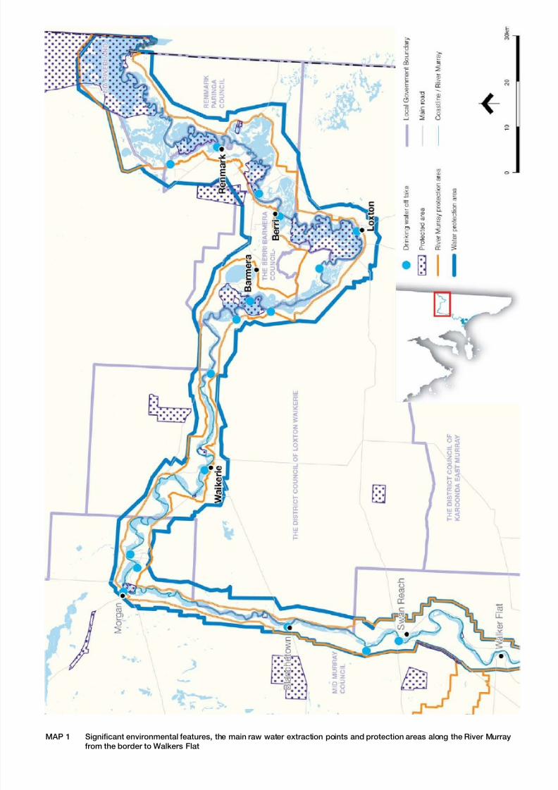
8/20/2019 Guide Marina and Mooring
http://slidepdf.com/reader/full/guide-marina-and-mooring 55/60
MAP 1 Significant environmental features, the main raw water extraction points and protection areas along the River Murray
from the border to Walkers Flat
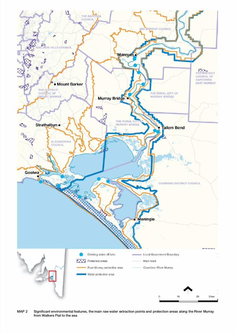
8/20/2019 Guide Marina and Mooring
http://slidepdf.com/reader/full/guide-marina-and-mooring 56/60
MAP 2 Significant environmental features, the main raw water extraction points and protection areas along the River Murray
from Walkers Flat to the sea

8/20/2019 Guide Marina and Mooring
http://slidepdf.com/reader/full/guide-marina-and-mooring 57/60
MAP 3 Location of all wetlands and key biodiversity areas along the Upper River Murray

8/20/2019 Guide Marina and Mooring
http://slidepdf.com/reader/full/guide-marina-and-mooring 58/60
MAP 4 Location of all wetlands and key biodiversity areas along the Lower River Murray and Lower Lakes

8/20/2019 Guide Marina and Mooring
http://slidepdf.com/reader/full/guide-marina-and-mooring 59/60
MAP 5 Locations of marinas along the Upper River Murray
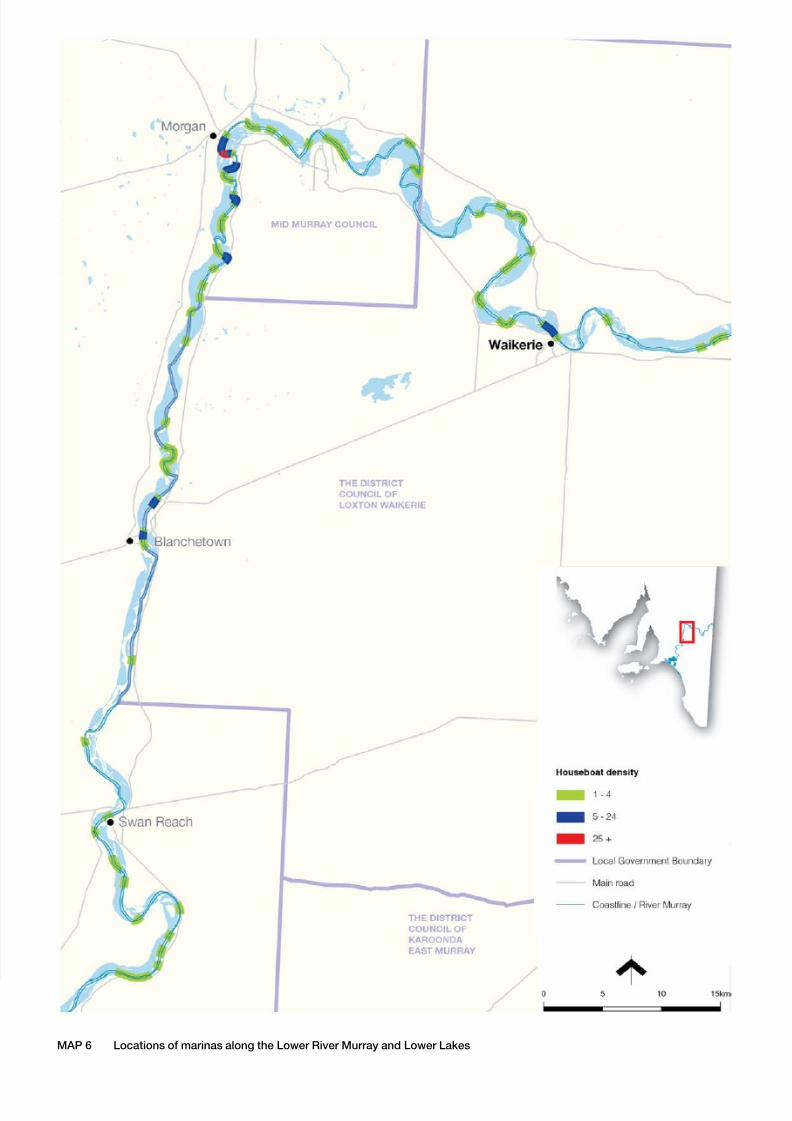
8/20/2019 Guide Marina and Mooring
http://slidepdf.com/reader/full/guide-marina-and-mooring 60/60